Note: Descriptions are shown in the official language in which they were submitted.
CA 02730114 2011-01-06
WO 2010/004081 PCT/F12009/050486
1
METHOD PROVIDING POSITIONING AND NAVIGATION INSIDE
LARGE BUILDINGS
FIELD OF THE INVENTION
The present invention relates generally to positioning and navigation systems.
More
particularly, the present invention relates to the use of Wireless Local Area
Network Access
Point (WLAN AP) locations in conjunction with maps, building floor plans, and
specification
standards for positioning and navigation purposes inside structures such as
large buildings
where Global Positioning System (GPS) signals are generally unavailable.
BACKGROUND OF THE INVENTION
This section is intended to provide a background or context to the invention
that is recited in
the claims. The description herein may include concepts that could be pursued,
but are not
necessarily ones that have been previously conceived or pursued. Therefore,
unless
otherwise indicated herein, what is described in this section is not prior art
to the description
and claims in this application and is not admitted to be prior art by
inclusion in this section.
Various methods have been developed for determining the location of the mobile
terminal.
For example, some mobile terminals may include GPS as part of the device. GPS
systems/services utilize satellites to triangulate to the location of a GPS-
enabled device.
Alternatively, other methods utilize a ground based network of antennas or
base stations to
determine the mobile terminal location. For example, an application program
might make a
request to a wireless carrier network. The wireless carrier would then use one
of several
methods to determine a user's location on the wireless network and return the
latitude and
longitude coordinates to the application program. One method involves
identifying the cell
or base station closest to the mobile terminal. The antenna in communications
with the
mobile terminal may then be used to determine the relative direction of the
mobile terminal.
Using the round trip time, the distance from the base station can be
determined providing an
location with an accuracy approaching 100 meters. Another method using
multiple base
stations may be used in some circumstances. The location of the mobile
terminal can be
determined using typically three base stations capable of communicating with
the mobile
terminal and triangulating the estimated location of the mobile terminal from
each individual
base station. More precise location estimates approaching 30 meters can be
achieved using
this method.
It is currently not possible for an electronic device, such as a mobile
device, to position itself
and to navigate within large buildings, e.g., malls, large office buildings,
public buildings
CA 02730114 2013-08-22
2
(museums, city halls, conference centers, etc.), covered parking lots, etc.
Structures and buildings
such as these can be up to 1 mile long, for example, with multiple entrances,
multiple floors, multiple
sections, wings, and in the case of malls, an abundance of shops.
Certain location and navigation systems utilize signals from at least one WLAN
AP when such signals
are available. For example, Skyhook (skyhookwireless.com) uses a technology
for outdoor
positioning and navigation (based on WLAN AP locations). However, such
technology operates by
mapping a WLAN AP beacon (that is found by driving around and scanning) to
geolocation
coordinates, where the signal was detected, thus still necessitating GPS
signal availability. U.S.
Patent No. 7,228,136 and U.S. Patent Publication No. 2007/0149215 describe
using WLAN for
location using triangulation of signals on multi channel mobile devices, while
U.S. Patent No.
6,807,478 described in-building navigation using light sources. Additionally,
a report entitled "The
Integration of Positioning Technologies for Precise Location Identification"
by T.Y. Chew, available
at http://ro.uow.edu.au/thesesinfo/5/, describes the integration of multiple
positioning technologies,
e.g., combining GPS and Third Generation (3G) networks.
SUMMARY OF THE INVENTION
Various embodiments allow for positioning and/or navigation of an electronic
device within a
building when, e.g., GPS signals, are unavailable. The electronic device scans
for available WLAN
APs upon entering or coming within close proximity to a building or structure.
If at least one
available WLAN AP exists, the electronic device detects a signal from the at
least one available
WLAN AP. The detected signal can be a beacon signal, for example, whereupon
the electronic
device retrieves the location of the at least one available WLAN AP.
Retrieving the location of the
WLAN AP can include directly downloading the location information from the
WLAN AP via a
Native Query Protocol which in accordance with various embodiments, includes
an extension to
currently defined Native Query info elements that returns location
information. Alternatively, the
electronic device may read the at least one available WLAN AP's Media Access
Control (MAC)
address from, e.g., the beacon signal, and use that to retrieve the location
of the WLAN AP from an
associated database, where the location of the WLAN AP is associated
with/derived from, e.g.,
extension elements describing indoor location. Additionally, various
embodiments may be
implemented with or via a mapping application or service.
CA 02730114 2014-09-08
2a
Accordingly, in one aspect there is provided a method comprising: scanning for
available wireless
local area network access points within a structure; detecting a signal from
at least one available
wireless local area network access point among the available wireless local
area network access
points; and retrieving location information of the at least one available
wireless local area network
access point, by querying the at least one available wireless local area
network access point for locally
configured data while in an unauthenticated state, via a query protocol,
wherein the locally configured
data comprises an 802.11u native query protocol AP location information
definition extension
indicative of the location information, wherein the scanning, the detecting,
and the retrieving are
performed by a mobile user device without associating with the at least one
available wireless local
area network access point.
According to another aspect there is provided an apparatus comprising: at
least one processor; and at
least one memory including computer program code for one or more programs, the
at least one
memory and the computer program code configured to, with the at least one
processor, cause the
apparatus to perform at least the following; scan for available wireless local
area network access
points within a structure; detect a signal from at least one available
wireless local area network access
point among the available wireless local area network access points; and
retrieve location information
of the at least one available wireless local area network access point, by
querying the at least one
available wireless local area network access point for locally configured data
while in an
unauthenticated state, via a query protocol, wherein the locally configured
data comprises an 802.11u
native query protocol AP location information definition extension indicative
of the location
information, wherein the apparatus is included in a mobile user device that
does not associate with the
at least one available wireless local area network access point during the
scanning, the detecting, and
the retrieving.
CA 02730114 2014-09-08
2b
According to yet another aspect there is provided a non-transitory computer-
readable storage medium
carrying one or more sequences of one or more instructions which, when
executed by one or more
processors, cause an apparatus to at least perform the following steps:
scanning for available wireless
local area network access points within a structure; detecting a signal from
at least one available
wireless local area network access point among the available wireless local
area network access
points; and retrieving location information of the at least one available
wireless local area network
access point, by querying the at least one available wireless local area
network access point for locally
configured data while in an unauthenticated state, via a query protocol,
wherein the locally configured
data comprises an 802.11u native query protocol AP location information
definition extension
indicative of the location information, wherein the scanning, the detecting,
and the retrieving are
performed by a mobile user device without associating with the at least one
available wireless local
area network access point.
These and other advantages and features of various embodiments of the present
invention, together
with the organization and manner of operation thereof, will become apparent
from the following
detailed description when taken in conjunction with the accompanying drawings,
wherein like
elements have like numerals throughout the several drawings described below.
CA 02730114 2011-01-06
WO 2010/004081 PCT/F12009/050486
3
drawings, wherein like elements have like numerals throughout the several
drawings
described below.
BRIEF DESCRIPTION OF THE DRAWINGS
Embodiments of the invention are described by referring to the attached
drawings, in which:
Figure 1 is an overview diagram of a system within which various embodiments
of the
present invention may be implemented;
Figure 2 is a perspective view of an electronic device that can be used in
conjunction with the
implementation of various embodiments of the present invention; and
Figure 3 is a schematic representation of the circuitry which may be included
in the electronic
device of Figure 2.
Figure 4 is a graphical representation of a shopping mall floor plan for which
positioning and
navigation in accordance with various embodiments can be utilized.
Figure 5 is graphical representation of a shopping mall street plan for which
positioning and
navigation in accordance with various embodiments can be utilized.
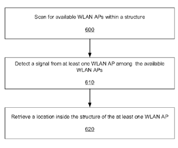
Figure 6 is a flow chart illustrating processes performed to achieve
positioning and/or
navigation in accordance with various embodiments.
DETAILED DESCRIPTION OF THE PREFERRED EMBODIMENTS
Figure 1 shows a system 10 in which various embodiments of the present
invention can be
utilized, comprising multiple communication devices that can communicate
through one or
more networks. The system 10 may comprise any combination of wired or wireless
networks
including, but not limited to, a mobile telephone network, a wireless Local
Area Network
(LAN), a Bluetooth personal area network, an Ethernet LAN, a token ring LAN, a
wide area
network, the Internet, etc. The system 10 may include both wired and wireless
communication devices.
For exemplification, the system 10 shown in Figure 1 includes a mobile
telephone network
11 and the Internet 28. Connectivity to the Internet 28 may include, but is
not limited to,
long range wireless connections, short range wireless connections, and various
wired
connections including, but not limited to, telephone lines, cable lines, power
lines, and the
like.
The exemplary communication devices of the system 10 may include, but are not
limited to,
an electronic device 12 in the form of a mobile telephone, a combination
personal digital
assistant (PDA) and mobile telephone 14, a PDA 16, an integrated messaging
device (IMD)
18, a desktop computer 20, a notebook computer 22, etc. The communication
devices may
CA 02730114 2011-01-06
WO 2010/004081 PCT/F12009/050486
4
be stationary or mobile as when carried by an individual who is moving. The
communication
devices may also be located in a mode of transportation including, but not
limited to, an
automobile, a truck, a taxi, a bus, a train, a boat, an airplane, a bicycle, a
motorcycle, indoor
electric transport devices, etc. Some or all of the communication devices may
send and
receive calls and messages and communicate with service providers through a
wireless
connection 25 to a base station 24. The base station 24 may be connected to a
network server
26 that allows communication between the mobile telephone network 11 and the
Internet 28,
where the network server 26 may be located in a building or structure (not
shown). It should
be noted that the network server 26 may not be needed to allow communication
between the
Internet and an electronic device, and the network server 26 may act as a
database for storing
WLAN AP location information. The system 10 may include additional
communication
devices and communication devices of different types.
Communication devices may communicate using various transmission technologies
including, but not limited to, Code Division Multiple Access (CDMA), Global
System for
Mobile Communications (GSM), Universal Mobile Telecommunications System
(UMTS),
Time Division Multiple Access (TDMA), Frequency Division Multiple Access
(FDMA),
Transmission Control Protocol/Internet Protocol (TCP/IP), Short Messaging
Service (SMS),
Multimedia Messaging Service (MMS), e-mail, Instant Messaging Service (IMS),
Bluetooth,
IEEE 802.11, Worldwide Interoperability for Microwave Access (WiMax), LTE,
etc. A
communication device involved in implementing various embodiments of the
present
invention may communicate using various media including, but not limited to,
radio,
infrared, laser, cable connection, and the like.
Figures 2 and 3 show one representative electronic device 12 within which the
present
invention may be implemented. It should be understood, however, that the
present invention
is not intended to be limited to one particular type of device. The electronic
device 12 of
Figures 2 and 3 includes a housing 30, a display 32 in the form of a liquid
crystal display, a
keypad 34, a microphone 36, an ear-piece 38, a battery 40, an infrared port
42, an antenna 44,
a smart card 46 in the form of a UICC according to one embodiment, a card
reader 48, radio
interface circuitry 52, codec circuitry 54, a controller 56 and a memory 58.
Individual
circuits and elements are all of a type well known in the art.
In accordance with various embodiments, an application/system is provided that
allows for
the positioning a device inside, e.g., a building, whenever a signal from at
least one WLAN
AP is available. Additionally, various embodiments offer the ability to
provide navigation to
one or more desired destinations inside the building (e.g., a specific shop in
case of malls or a
CA 02730114 2011-01-06
WO 2010/004081 PCT/F12009/050486
cubicle number in the case of office buildings). In contrast to conventional
systems, WLAN
location can be utilized in accordance with various embodiments for
positioning and/or
navigation even when GPS signals are not available by acquiring WLAN location
information from APs themselves. Moreover, various embodiments enable
positioning
5 relative to/against a building's floor plan, which enables navigation
capabilities and provide
directory information (e.g., in the case of malls) which enables locating a
specific store by its
name.
The need/desire to provide wireless Internet connection in, e.g., offices and
public buildings
is apparent, while nowadays more and more shops have wireless Internet
connection inside
the store either for conducting more efficient business or for the benefit of
employees, for
resale of Internet access on the go, etc. Conventionally, access to such
wireless Internet
connections are often restricted to authorized users only. However, the nature
of WLAN
technology (where the MAC address of an AP is broadcasted and can be read by
any WLAN
station scanning for the beacon) enables exploitation of the presence of WLAN
signals for
use with indoor positioning and navigation systems in accordance with various
embodiments.
The Institute of Electrical and Electronic Engineers (IEEE) 802.11v standard
Working Group
(WG) has defined a method which allows WLAN stations associated with a WLAN AP
to
download the location of the AP. However, certain issue exist with using this
feature in a
public building as currently proposed. For example, retrieving the location of
the WLAN AP
involves an association with the WLAN AP which can be time consuming. Also, as
described above, association to WLAN APs may be restricted to authorized
users, and thus
the location of a WLAN AP is also only available for those authorized users.
If the WLAN
AP provides free access (e.g., wireless "hotspots" such as Starbucks,
airports, etc.), then
location can be retrieved for free as well. However and again, free access is
not always the
case. Furthermore, issues arise with regards to the type of location that can
be configured for
a WLAN AP inside, e.g., a building.
There are currently two location formats which are widely supported: civic
location (e.g.,
postal address) and geolocation (e.g., location coordinates, WGS 84). In the
case of a
building, the civic location usually points to/is representative of the main
entrance of the
building, although in certain cases, secondary entrances may also have a
separate civic
address. Current standards for civic address format as presented in RFC3825,
RFC4119 and
extended by RFC4776 and RFC5139, do not allow for a hierarchical or detailed
indoor
addressing that would allow for further address-specific locations inside a
building. For
example, conference centers may have wings or sections as well as multiple
floors etc. Large
CA 02730114 2011-01-06
WO 2010/004081 PCT/F12009/050486
6
malls may have store numbers or even their own streets and street numbers
(which only have
local significance within the mall), etc.
Figure 4 is one example of a larger shopping mall 400, where positioning
inside the building
and navigation would be useful. The floor plan of the mall above shows the
name of certain
of the shops, e.g., 410a, 410b, 410c, etc., while for smaller shops a number
is displayed, e.g.,
415a, 415b, 415c, etc. However, this is only for display convenience as all
store numbers
need to be linked to the actual store name in the directory of the mall in
order to enable
locating a store by its name and making it possible to provide directions to
the store. Figure
5 is another example of a shopping mall 500 with its own streets, e.g., 510a,
510b, etc.
Again, it should be noted that these "mall streets" only have local
significance to the mall. In
the particular case illustrated in Figure 5, one of the street names 515c
found inside the mall
is also the name of the street associated with the main entrance to the mall
is (which is the
civic address of the mall).
Current civic address formats do include, e.g., street address, number, floor
number, room
number, seat number, etc., but this information cannot always be "reused" for
positioning
and/or navigation purposes inside structures as the internal structure and
addressing of a
building may conflict with the external one. Moreover, in most cases it is not
accurate
enough. Hence, a hierarchical description or indoor addressing is needed or,
at least, current
civic address types should be extended with locally significant fields
relative to the civic
address of the building.
Geolocation on the other hand is often times not available inside a building
because GPS
signals from satellites generally cannot be received within structures such as
buildings, and
thus do not provide assistance in determining a WLAN AP location. Even if an
operator of a
WLAN AP is willing to manually configure the geo-coordinates of a WLAN AP
located
inside a building, there are no automatic mechanisms for determining what
those geo-
coordinates would be.
Even considering that by using, e.g., an advanced GPS device, altitude
information associated
with a WLAN AP location can be determined, due to the nature of GPS signals,
altitude
accuracy is likely at only half of the accuracy which can be achieved for
longitude and
latitude coordinates. That is, the best accuracy that can be achieved for
altitude utilizing
geolocation is on the order of ¨10m, which in certain instances would cover 3
floors in some
buildings. T geolocation format is not suitable for positioning and navigation
inside large
CA 02730114 2011-01-06
WO 2010/004081 PCT/F12009/050486
7
buildings, except for some cases where a building's structure may, for
example, be only one
floor. In this case, manual configuration would be required.
Given the aforementioned issues, extensions to existing positioning and/or
navigation
standards are provided in accordance with various embodiments so as to allow
for the use of
WLAN location in an automatic way for positioning and/or navigation inside
buildings.
In accordance with various embodiments, extensions are provided for use with
regard to
certain standards. For example, the IEEE 802.11u standard WG defines a
mechanism which
allows WLAN devices to retrieve some data from a WLAN AP before association.
In
accordance with various embodiments, it is specified in the IEEE 802.11u
standard that one
type/piece of information to be retrieved without association, is the location
of the WLAN
AP. Therefore, such information is freely available for all WLAN devices (not
only to
authorized users), without requiring them to associate with the WLAN AP. It
should be
noted that bypassing the need for association can provide time savings as
conventional
association with a WLAN AP by itself can be time consuming, even if the WLAN
AP
provides free access. Moreover, freely providing the location of aWLAN AP is
not harmful
as anyone can with a WLAN device may freely perform scanning to determine
available
access points, read an associated MAC address, and save the location where the
signal was
seen/scanned.
Furthermore, the Internet Engineering Task Force (IETF) GEOPRIV civic location
data
format can also be extended to include civic address types which have local
significance
(e.g., wing, sector, tower, exhibition hall number, store name, store number,
street name,
street address, building facilities, internal floor number, airport name,
terminal number, gate
number, etc.) The location of a WLAN AP can either be natively configured into
the
management information base (MIB) of the WLAN AP, or a separate database can
be
configured to list the MAC address of the WLAN AP and its location inside the
building.
In accordance with various embodiments, a mapping application (or other
application/service
with mapping/positioning functionality) may also be extended by creating and
loading the
floor plan of various buildings of interest (e.g., airports, public buildings,
offices) into the
mapping application. This can be accomplished using scalable vector graphics
(SVG) for
example. Thus, when a user places a cursor/pointer over a representation of a
building on a
display of the mapping application, the building representation being
displayed switches to an
"indoor view" to display the floor plan of that building to the user. If
multiple floors exists in
the building's floor plan, one floor plan representative of, e.g., the ground
floor, may be
CA 02730114 2011-01-06
WO 2010/004081 PCT/F12009/050486
8
displayed by default. Moreover, floor plans of additional floors of the
building may be
displayed upon the user choosing an option to display the floor plan of an
additional floor.
It should be noted that extending the mapping application to include such
floor plans for
public buildings can be accomplished with relative ease because public
building floor plans
are generally available online and may be linked to a database utilized by the
mapping
application. Thus, a user, for example, may download a picture of a desired
public building
floor plan (e.g., a jpg file of the floor plan) to the mapping application.
Alternatively, the
floor plan may already be linked to a digital map, and thus a user may
navigate and the
mapping application displays the floor plan when the user/cursor is near or in
the building).
The mapping application may then display that floor plan picture to the user
when the user
places a cursor/pointer on the building, without positioning and navigation
capabilities. A
floor plan which enables positioning and navigation would utilize a floor plan
in a map
format using, e.g., an Extensible Markup Language (XML)-based map such as one
utilizing
SVG), although other formats are contemplated herein. Additionally, locations
inside of a
building are tagged and associated with either indoor civic locations or
calculated coordinates
(either relative to the building or WGS).
It should further be noted that various embodiments may be utilized with GPS-
capable
devices. That is, when a user with a GPS capable device comes within close
proximity of a
building, the mapping application described above (operating on the user's
electronic/mobile
device), automatically displays an "indoor view" option for that building to
the user. The
user may then switch to the indoor view and view the floor plan of the
building, if the user
chooses to, by selecting the indoor view option. How close a user is to a
building or structure
before the indoor view option is presented to the user may be configured
within the electronic
device at some prior time or may be configured by the user.
Once a user enters a building or structure, various processes are performed to
effectuate
positioning and navigation. Figure 6 is a flow chart illustrating various
processes in
accordance with various embodiments. An electronic/mobile device of the user
scans for
available WLAN APs within a structure at 600 upon entering or coming within
close
proximity to a building or the structure. At 610, if available WLAN APs exist,
the
electronic/mobile device detects a signal from the at least one of the
available WLAN APs.
At 620, the electronic/mobile device retrieves the location inside the
building or structure of
the at least one of the available WLAN APs.
CA 02730114 2011-01-06
WO 2010/004081 PCT/F12009/050486
9
In accordance with one embodiment, once the electronic/mobile device detects a
signal from
the at least one WLAN AP, the electronic/mobile device downloads the location
of the
WLAN AP. Downloading of the WLAN AP location is made possible by the
extensions
described above to the IEEE 802.11u standard and/or the WLAN AP is "open
access." In
this embodiment, a new info ID definition is added to the existing Native
Query protocol info
ID definitions table, which would permit downloading the APs location even
while in state-1.
Info Name Info ID Native Info Element (clause)
Capability List Information 1 7.3.3.1
Venue Name Information 3 7.3.3.2
Emergency Call Number 4 7.3.3.3
Information
Emergency Public Network 5 7.3.3.4
Access Information
Network Authentication Type 6 7.3.3.5
Information
Roaming Consortium List 7 7.3.3.6
Reserved 8-220 n/a
Vendor Specific Information 221 n/a
Reserved 222-255 n/a
AP Location Information 8 7.3.3.7
Table 1. Native Query protocol info ID definitions
The Native Query Protocol is a mechanism specified in the IEEE 802.11u
standard that
allows a non-AP STA (electronic/mobile device) to query an AP for locally
configured data.
Hence the AP can directly respond to queries without proxying the query to a
server or
external network, and the querying device need not associate with the WLAN AP.
It should
be noted that that other query protocols may be utilized to achieve various
embodiments. In
accordance with one embodiment and as described above, WLAN AP location
information
may be queried and downloaded. Using the WLAN AP location information
downloaded
from the WLAN AP, a position of the electronic/mobile device can be determined
inside the
building. Moreover, the mapping application described above may also be
configured to
display the name of the building the user is in.
If the extension to the IEEE 802.11u standard described above is not
supported, (e.g., the user
is denied access to the WLAN AP while in state-1 or the WLAN AP does not have
its
location configured), positioning and navigation inside the building is still
possible via
CA 02730114 2011-01-06
WO 2010/004081 PCT/F12009/050486
indirect methods such as using an external database. It should be noted that
state-1 refers to
an unauthenticated state.
Extensions to the IETF GEOPRIV civic location data format may be implemented.
That is,
5 additional civic address (CA) type (CAtype) elements are added to the
Presence Information
Data Format Location Object (PIDF-LO) format and/or Location Configuration
Information
(LCI) (RFC3825&RFC4776) that can more precisely refer to/label position
reference points.
Thus, when determining positioning through use of the IEFT GEOPRIV civic
location data,
more precise positioning can be accomplished. The PIDF-LO and LCI formats
10 conventionally support CAtype elements such as CAtype 28 indicative of
room, CAtype 33
indicate of seat, etc. Table 2 below lists additional CAtype elements in
accordance with one
embodiment. It should be noted that more (e.g., reference points such as
waterfalls, statues,
etc. located within a building) or fewer CAtype elements may be added to the
PIDF-LO
and/or LCI formats in accordance with various embodiments.
New Civic Field CAtype Description Example
Building section 401 Section of a building Sector-4
Building wing 402 Wing of a building Conf. wing
Building tower 403 Tower of a building Tapa tower
(e.g., in resort)
Internal street 404 Internal street name 19th Ave.
Internal street number 405 Internal street number 255
Store name 410 Name of store Gucci
Store number 411 Store number 463
Exhibition hall 406 Exhibition hall 22-4
name/number
Building facilities 408 Building facility Cafeteria
Internal floor number 407 Internal floor number 2
Airport name 420 Name of airport O'Hare
Terminal number 421 Terminal number 5
Gate number 422 Terminal gate number 8
Table 2. Exemplary list of additional/extension CAtype elements to PIDF-LO
and/or LCI
formats
It should be noted that the extensions to the IETF GEOPRIV civic address
format do not
necessarily need to be standardized for positioning inside the building to
work. That is, if all
of the requisite location data is always stored in a database associated with
the mapping
CA 02730114 2011-01-06
WO 2010/004081 PCT/F12009/050486
11
application or within the mapping application described above (as opposed to
in the actual
WLAN APs), positioning would still be possible through the use of the mapping
application.
In this case, the CAtype elements would then be specific to a particular
service or application,
e.g., the mapping application.
In accordance with another embodiment, upon scanning for available APs and
detecting a
WLAN AP signal (e.g., a beacon of a WLAN AP), the electronic/mobile device
reads the
MAC address of the WLAN AP from the beacon. Subsequently, the location of the
WLAN
AP is retrieved from a database, using the MAC address to identify the correct
location
information associated beforehand with the particular WLAN AP in the database.
That is,
the MAC address is utilized as, e.g., a pointer, to the location information
associated with the
WLAN AP that is stored in the database, where the location comprises the IETF
GEOPRIV
CAtype extension elements described above. The building's management may
provide a
database of the installed WLAN APs in that building along with their location
relative to the
floor plan. This data can be uploaded into a mapping application as described
above. If such
a database is not available, a database can be constructed by simply walking
through the
building with a WLAN device and recording the MAC addresses in the beacons
found while
scanning, together with the civic location fields/CAtype extension elements
described above
relative to the floor plan. Again, this data can then be uploaded to a
database accessible to
the mapping application.
Additionally, the mapping application can provide an Application Programming
Interface
(API) for users to populate such a database by specifying the location of the
WLAN AP
inside the building using CAtype extension elements described above. For
example, when a
user finds a WLAN AP with a MAC address not yet in the database, the user
could request
that the WLAN AP be added to the database. After the request is verified and
found
legitimate, the user may get an incentive for his/her contribution.
Alternatively still, different
locations within a building may be identified by geocoordinates instead of
civic addresses.
For example, a building corner may have coordinates (a,b), where the position
of reference
points/places inside the building can be calculated relative to that corner.
The coordinates of
the corner can be "true" geolocation (latitude, altitude) coordinates, but it
could well be (0,0)
and the position of the rest of the places could be calculated, e.g., in a
cartesian coordinate
system. However, labels/names for the reference points/places inside the
building need to be
identified (e.g., store 123 has coordinates (c,d), or gate 86 in terminal 3
has coordinates (e,f))
which can be assigned coordinates.
CA 02730114 2011-01-06
WO 2010/004081 PCT/F12009/050486
12
Various embodiments described above can determine the location of an
electronic/mobile
device by determining a location of a WLAN AP. That is, for positioning and/or
navigation
purposes, the location of the electronic/mobile device can be assumed to be
that of the
WLAN AP when it is in sufficient proximity to the WLAN AP to, e.g., detect a
signal from
the WLAN AP. However, if more than one WLAN AP signal is detected,
triangulation or
simple geometric "shaping" can be used by the device to calculate a more
precise
position/location. The accuracy of a determined position/location can also be
calculated and
displayed on a display of the floor plan with the mapping application, e.g. in
the form of
shadow around the calculated position.
Navigation can be provided by connecting or relating a determined or
calculated
position/location of an electronic/mobile device with a desired destination.
The desired
destination may be specified by a user of the electronic/mobile device by,
e.g., scrolling
through a display of a particular floor plan, and pointing a cursor
at/indicating a location
inside the building. Alternatively, the user may specify a civic address with
local
significance (e.g., building wing, tower, store number, store name, hall,
building facility,
airport name, terminal or gate number, internal street name and number, etc.)
Furthermore,
the reference point/location may be labled, tagged and/or linked to a building
directory to
provide navigation capability.
Various embodiments described herein are described in the general context of
method steps
or processes, which may be implemented in one embodiment by a computer program
product, embodied in a computer-readable medium, including computer-executable
instructions, such as program code, executed by computers in networked
environments. A
computer-readable medium may include removable and non-removable storage
devices
including, but not limited to, Read Only Memory (ROM), Random Access Memory
(RAM),
compact discs (CDs), digital versatile discs (DVD), etc. Generally, program
modules may
include routines, programs, objects, components, data structures , etc. that
perform particular
tasks or implement particular abstract data types. Computer-executable
instructions,
associated data structures, and program modules represent examples of program
code for
executing steps of the methods disclosed herein. The particular sequence of
such executable
instructions or associated data structures represents examples of
corresponding acts for
implementing the functions described in such steps or processes.
Embodiments of the present invention may be implemented in software, hardware,
application logic or a combination of software, hardware and application
logic. The
software, application logic and/or hardware may reside, for example, on a
chipset, a mobile
CA 02730114 2013-08-22
13
device, a desktop, a laptop or a server. Software implementations of various
embodiments can be
accomplished with standard programming techniques with rule-based logic and
other logic to
accomplish various database searching steps or processes, correlation steps or
processes, comparison
steps or processes and decision steps or processes. Various embodiments may
also be fully or
partially implemented within network elements or modules. It should be noted
that the words
"component" and "module," as used herein and in the following claims, is
intended to encompass
implementations using one or more lines of software code, and/or hardware
implementations, and/or
equipment for receiving manual inputs.
Individual and specific structures described in the foregoing examples should
be understood as
constituting representative structure of means for performing specific
functions described in the
following the claims, although limitations in the claims should not be
interpreted as constituting
"means plus function" limitations in the event that the term "means" is not
used therein. Additionally,
the use of the term "step" in the foregoing description should not be used to
construe any specific
limitation in the claims as constituting a "step plus function" limitation. To
the extent that individual
references, including issued patents, patent applications, and non-patent
publications, are described or
otherwise mentioned herein, such references are not intended and should not be
interpreted as limiting
the scope of the following claims.
The foregoing description of embodiments has been presented for purposes of
illustration and
description. The foregoing description is not intended to be exhaustive or to
limit embodiments of
the present invention to the precise form disclosed, and modifications and
variations are possible
within the scope of the claims, in light of the above teachings or may be
acquired from practice of
various embodiments. The embodiments discussed herein were chosen and
described in order to
explain the principles and the nature of various embodiments and its practical
application to enable
one skilled in the art to utilize the present invention in various embodiments
and with various
modifications within the scope of the claims as are suited to the particular
use contemplated. The
features of the embodiments described herein may be combined in all possible
combinations of
methods, apparatus, modules, systems, and computer program products within the
scope of the
claims.