Note: Descriptions are shown in the official language in which they were submitted.
CA 02731561 2011-01-20
WO 2009/064997 PCT/US2008/083573
TAGGING A FORMATION FOR USE IN WELLBORE RELATED
OPERATIONS
INVENTORS: KIRKWOOD, Andrew D. and
MONROE, Stephen P.
BACKGROUND OF THE DISCLOSURE
Field of the Disclosure
[0001] This disclosure relates generally to devices, systems and
methods for positioning and using equipment used in connection with
the drilling, completion and /or workover of oilfield wells.
Description of the Related Art
[0002] Valuable hydrocarbon deposits, such as those containing oil
and gas, are often found in subterranean formations located thousands
of feet below the surface of the Earth. To recover these hydrocarbon
deposits, boreholes or wellbores are drilled by rotating a drill bit
attached to a drilling assembly, also referred to herein as a "bottom hole
assembly" or "BHA." Such a drilling assembly is attached to the
downhole end of a tubing or drill string made up of jointed rigid pipe or a
flexible tubing coiled on a reel ("coiled tubing"). For directional drilling,
the drilling assembly can use a steering unit to direct the drill bit along a
desired wellbore trajectory.
[0003] These drilled wellbores, which can include complex three-
dimensional trajectories, intersect various formations of interest. During
drilling and in later completion activities, success or failure of effectively
producing hydrocarbons from a given formation can hinge on precisely
measuring the depth of a given formation and precisely positioning a
wellbore tool at a depth corresponding to a given formation. In some
instances, a hydrocarbon bearing zone can be only a meter or so in
depth. Thus, the positioning of wellbore tools such as a perforating gun
-1-
Printed: 29/09/2009 DESCPAMD IJS2008083573
Sep-14-2009 03:49pm From-BAKER HUGHES LEGAL 713-625-5857 T-147 P.016/017 F-931
564-45327-WO
SUBSTITUTE SHEET
or a kickoff for a lateral bore must be positioned well within that one
meter range.
[0004] Conventional depth measurement systems utilize surface-
based equipment and techniques for determining a measured depth of a
downhole tool, such as a bottomhole assembly. Conveyance devices,
such as drill pipe or wirelines, that used to convey downhole tooling are
susceptible to stretching during deployment. Because these
conveyance devices can span hundreds of meters or more, the
elongation of the conveyance device may significantly impact surface
depth measurements. That is, for instance, a surface measurement
may indicate that a downhole tool is at 800 meters, whereas, due to
factors such as tensile loading, the tool is actually at 840 meters. Thus,
surface measurements may not provide the accuracy needed to position
wellbore equipment within a narrow zone of interest, e.g., within a
tolerance of a half-meter. The present disclosure is directed to methods
and devices for accurately positioning wellbore tooling as well as
methods and devices for enhancing wellbore operations.
[00051 UK Patent Application GB 2,360,553 by Homan et al.
discloses a downhole tool that locates a remote sensing unit deployed
in a formation, powers the remote sensing unit, and retrieves formation
data collected by the remote sensing unit. European Patent Application
EP 1,662,673 by Chouzenoux et al. discloses a system for passing an
electromagnetic signal through a casing between a tool body positioned
inside the casing and one or more sensors located outside the casing.
U.S. Patent Application Pub. No. 200610005965 by Chouzenoux at al.
discloses a sensor for installation in an underground well having a
casing or tubing installed therein. A sensor body is installed in a hole
formed in the casing so as to extend between the inside and outside of
the casing. Sensor elements located within the sensor body are
capable of sensing properties of the formation. Communication
elements within the sensor body are capable of communicating
AMENDED SHEET
leceived at the EPO on Sep 14, 2009 23:28:43. Page 16 of 17
14/09/2009'
CA 02731561 2011-01-20
'Printed 29/09/2009; DESCPAMD US2008083573;
Sep-14-2009 03:49pm From-BAKER HUGHES LEGAL 713-625-5857 T-147 P.017/017 F-931
564-45327-WO3
SUBSTITUTE SHEET
information between the sensor elements and a communication device
in the well. European Patent Application EP 1,048,113 by Ciglenec et
al. discloses an apparatus and method for gather data from a
subsurface formation and includes a shell that is adapted for sustaining
forcible propulsion into the subsurface formation. A data sensor is
disposed within the chamber of the shell. European Patent Application
EP 984,135 by Ciglenec et al. discloses a method and apparatus for
establishing communication in a cased wellbore with a data sensor that
has been remotely deployed into a subsurface formation penetrated by
io the wellbore prior to the installation of the casing. UK Patent Application
GB 2,404,208 by Fields discloses a downhole tool for reducing debris in
a wellbore perforation. The tool comprises a housing that can be
positioned in the wellbore, an arm and a debris blocker mounted in the
housing. The arm extends into the perforation and positions the debris
blocker to block debris from formation fluid flowing from the perforation
into the housing.
SUMMARY OF THE DISCLOSURE
[0006] In aspects, the present disclosure provides a method for
positioning a wellbore tool in a wellbore intersecting a subterranean
formation. In one embodiment, the method may include positioning a
tag at a selected location in the formation, and positioning the wellbore
tool in the welibore with reference to the tag. In aspects, another
method for positioning a wellbore tool in a wellbore intersecting a
subterranean formation include determining a parameter of interest
relating to the formation; determining a selected location along the
wellbore using the determined parameter of interest; positioning a tag at
the selected location in the formation; detecting the tag; and positioning
the wellbore tool in the wellbore with reference to the tag. The method
may further include logging a section of the formation to measure the
-2A-
AMENDED SHEET
received at the EPO on Sep 14, 2009 23:28:43. Page 17 of 17
2
CA 02731561 2011-01-20 14/09/2009;
CA 02731561 2011-01-20
WO 2009/064997 PCT/US2008/083573
parameter of interest relating to the formation, and re-logging the
section of the wellbore to locate the selected location. In aspects, still
another method for positioning one or more devices in a wellbore
intersecting a subterranean formation may include logging a section of
the formation while traversing the wellbore in a first direction to obtain a
first set of data relating to the formation; determining a selected location
along the wellbore by processing the first set of data; logging the section
of the formation while traversing the wellbore in a second direction
opposite to the first direction to obtain a second set of data relating to
the formation; processing the second set of data to find the selected
location; and positioning a tag at the selected location in the formation.
[0006] In aspects, the present disclosure provides a system for
positioning a wellbore tool in a wellbore intersecting a subterranean
formation. The system may include a tag positioned in the formation; a
is tag detection device operatively linking to the tag; and a conveyance
device conveying the tag detection device into the wellbore. An
illustrative system may include a logging tool configured to determine at
least one parameter of interest relating to the formation; a tag
configured to be positioned in the formation; a tag insertion tool
configured to insert the tag into the formation; and a conveyance device
conveying the tag insertion tool and the logging tool into the wellbore. In
aspects, another illustrative system may include a tag configured to be
embedded in the subterranean formation to operate as the reference
object; and an injector configured to embed the tag into the
subterranean formation.
[0007] It should be understood that examples of the more important
features of the disclosure have been summarized rather broadly in order
that the detailed description thereof that follows may be better
understood, and in order that the contributions to the art may be
appreciated. There are, of course, additional features of the disclosure
that will be described hereinafter and which will form the subject of the
claims appended hereto.
-3-
CA 02731561 2011-01-20
WO 2009/064997 PCT/US2008/083573
BRIEF DESCRIPTION OF THE DRAWINGS
[0008] For detailed understanding of the present disclosure,
references should be made to the following detailed description of the
preferred embodiment, taken in conjunction with the accompanying
drawings, in which like elements have been given like numerals and
wherein:
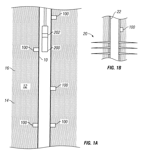
Figure 1 A schematically illustrates a reference tag according to one
embodiment of the present disclosure that is embedded in a subterranean
formation; and
Figure 1 B schematically illustrates a reference tag according to one
embodiment of the present disclosure that is embedded in a subterranean
formation and positioned radially external of a wellbore tubular;
Figure 2 functionally illustrates a tag according to one embodiment
of the present disclosure;
Figures 3A and 3B schematically illustrate tag insertion tools made
according to one embodiment of the present disclosure;
Figure 4 shows a schematic view of a drilling system according to
one embodiment of the present disclosure; and
Figure 5 shows a schematic view of wireline system according to
one embodiment of the present disclosure.
DETAILED DESCRIPTION OF THE DISCLOSURE
[0009] The present disclosure, in one aspect relates to devices and
methods for positioning wellbore tools and / or obtaining subsurface
measured data. The present disclosure is susceptible to embodiments
of different forms. There are shown in the drawings, and herein will be
described in detail, specific embodiments of the present disclosure with
the understanding that the present disclosure is to be considered an
exemplification of the principles of the disclosure, and is not intended to
limit the disclosure to that illustrated and described herein. Further,
while embodiments may be described has having one or more features
or a combination of two or more features, such a feature or a
-4-
CA 02731561 2011-01-20
WO 2009/064997 PCT/US2008/083573
combination of features should not be construed as essential unless
expressly stated as essential.
[0010] Referring initially to Fig. 1 A, there is shown a wellbore 10
intersecting a formation 12. In embodiments, one or more tags 100 are
positioned along the wellbore 10 at selected locations in the rock and
earth of the formation 12. The tags 100 operate as a reference object
or device that may assist in determining the orientation and / or position
of one or more tools subsequently deployed in the wellbore 10. An
illustrative tool, which has been labeled with numeral 200, may be any
tool used during any stage of the life of a well, including drilling,
completion, work-over and production. In embodiments, the tool 200
may include a tag detection device 202 that operatively links to the tags
100. This operative link may be as simple as a detection of the tag 100
or as complex as a bi-direction data communication with and power
is transfer to the tag 100. Establishing this operative link provides an
indication that the tool 200 has reached a previously identified location
in the wellbore, provides information that may be useful in operating the
tool 200, and / or facilitates a desired wellbore operation. The data and
information may be transmitted to the surface and / or used downhole.
[0011] The tag 100 may be used to orient and /or position the wellbore
tool 200 with reference to a location parameter such as measured
depth, true vertical depth, borehole highside, azimuth, etc. The
orientation and /or position may also be with reference to a subsurface
feature such as a production zone 14, a water zone 16, a particular
point or region of interest in the formation 12, as well as features such a
bed boundaries, fluid contacts between fluids such as water and oil,
unstable zones, etc. Referring now to Fig. 1 B, the tag 100 may also be
used in connection with constructed features such as a perforated zone
20 or other features as kick-off points (not shown) for branch wells,
locations of liner hangers (not shown), packers (not shown) etc. The
tag 100 may be used in an open hole as shown in Fig. 1 A or radially
-5-
CA 02731561 2011-01-20
WO 2009/064997 PCT/US2008/083573
external to wellbore equipment such as tubular 22, which may be a liner
or casing.
[0012] In one mode of operation, the tool 200 uses the tag detection
device 202 to detect, communicate, or in some manner operatively link
with the tag 100. Upon establishing this operative link with the tag 100,
surface personnel can then determine the position of the tool 200
relative to the feature of interest. The tool 200 may be operated to
locate the tag 100, which then enables positioning of the tool 200
relative to the tag 100.
[0013] While the tag 100 may operate in some embodiments as a
substantially stationary reference object that may be used to position
wellbore tools, the tag 100 may also be configured to receive, collect,
store and transmit information. The configuration of the tag 100,
therefore, may be adjusted as needed to meet a particular function.
Referring now to Fig. 2, there is shown in functional format one
embodiment of a tag 100. It is emphasized that the features shown in
Fig. 2 may be optional and as such are not essential.
[0014] In one arrangement, the tag 100 emits an identifiable signal
102. The characteristics of the signal 102, such as amplitude or
frequency, may be sufficient for the tool 200 to identify or locate the tag
100. The signal 102, in certain embodiments, may also contain
information that includes, but is not limited to, a unique identification
value for that tag 100. In certain embodiments, the signal 102 may
include data such as reservoir data such as pressure, temperature, flow
rates; formation data such as resistivity, density, porosity; fluid data
such as fluid composition, borehole data such as highside, borehole
diameter; directional data such as inclination, azimuth, etc. The data
may be measurements made by in situ sensors or by tools that have
previously run in the wellbore 10. In certain embodiments, the signal
102 may include position data such as a distance to one or more
features of interest described previously. The signals may be digital,
analog, encoded pulses or any other information-bearing transmission.
-6-
CA 02731561 2011-01-20
WO 2009/064997 PCT/US2008/083573
[0015] The constituent components of the tag 100 may depend on the
particular application involved, the nature the signal 102 and / or the
degree of information that is to be conveyed by the signal 102. For
instance, the tag 100 may utilize a transmitter 110 that transmits a
signal having a predetermined characteristic such as amplitude or
frequency that enables identification of the tag 100. To add information
to the signal 102, a memory 112 may be utilized to store data. The data
may be written to the memory 112 by an external device (not shown) or
by a resident data writer 114. In some embodiments, the tag 100 may
operate continuously or periodically. In some embodiments, a receiver
116 may be used to receive command signals or data signals
transmitted to the tag 100. For instance, the tag 100 may assume a
"sleep" or "dormant" mode until a command signal is received by the
receiver 116. Upon receiving the command signal, the transmitter 110
may transmit the signal 102. The receiver 116 may also be used to
receive data that is thereafter written to the memory 112 by the writer
114. In embodiments, a sensor 118 may be used to measure one or
more desired parameters of interest and a processor 120 may be used
to process the measured data or any other received data. The
processing may include, but is not limited to, digitizing, decimating,
filtering, etc. The transmitter 100 may include an onboard power supply
122, which may be rechargeable. The transmitter 100 may also be
energized by using as an induction device on a tool or by a suitable
power conductor to a remote power supply in the wellbore or at the
surface.
[0016] In one arrangement, the tag 100 may use radio frequency
identification (RFID) principles to establish an operative link with the tool
200. In such an arrangement, the tag 100 may include a transponder
124 and the tag detection device 202 of the tool 200 may include an
interrogator or transceiver 204. The transponder 124 transmits the
signal 102 in response to an interrogating signal 126 transmitted by the
transceiver 204. The transponder 124 can be passive or active. In one
variant of the passive transponder 124, an incoming radio frequency
-7-
CA 02731561 2011-01-20
WO 2009/064997 PCT/US2008/083573
signal or interrogating signal 126 generates sufficient electrical current
induced in an antenna (not shown) provided in the transponder 124 for
circuitry such as a CMOS integrated circuit in the transponder 124 to
power up and transmit the responsive signal 102. As noted previously,
the responsive signal 102 can include a preprogrammed value such as
an ID number as well as collected data. In one variant of the active
transponder 124, the internal power source 122 supplies power for the
onboard circuitry. The active transponder 124 can transmit such signals
in response to a signal or transmit the signals without a prompt at a
io specified time, event or interval.
[0017] It is emphasized that RFID devices are merely illustrative of
devices that be used to establish communication between the tag 100
and the tag detection device 202. In other embodiments, operative links
between the tag 100 and the tag detection device 202 may be based on
acoustic signals, magnetic signals, optical signals, pressure pulses or
other energy waves that may be emitted or modulated in a controlled
manner. For example, the tag 100 may be partially or completed
formed of an energy emitting material such as a radioactive material or
a magnetic material. The energy emitting materials may be
encapsulated in a shell or sheathing that is substantially transparent to
the emitted energy. The encapsulation may be useful to protect the
energy emitting material for the corrosive wellbore environment and
help prevent the energy emitting material from migrating or dispersing.
The tag detection device 202 may be equipped with a device to detect
the energy emitted by the tag 100, such as a radiation detector or
magnetometer.
[0018] The tag 100 may be embedded into the formation using any
number of devices, two of which are shown in Figs. 3A and 3B. Fig. 3A
illustrates an insertion tool 300 that plants the tag 100 in a controlled
manner into the formation. The insertion tool 300 includes an injection
module 302 and one or more decentralizing arms 304. The injection
module 302 may include an injector 306, a control unit or controller 308
-8-
CA 02731561 2011-01-20
WO 2009/064997 PCT/US2008/083573
and a power supply 310. The injection module 302 may be configured
to use electrical power, hydraulic power and / or pneumatic power. In
one arrangement, the injector 306 may be a piston or ram device that is
actuated by pressurized fluid, such as oil or gas. For example, the tag
100 may be fixed to a member such as a pad or a rod (not shown) that
is driven against or into the formation. In other embodiments, the tag
100 may be inserted into the formation by being loaded into a member
such as a tube that is operatively coupled to a charge device that
provides a propelling force using hydraulics, pneumatics or
pyrotechnics. In other embodiments, the injection module 302 may
utilize an expandable bladder that is expanded into engagement with a
wellbore wall. In still other arrangements, an electric motor can rotate
an appropriately threaded shaft to drive a tag 100 into the formation. In
still other embodiments, the injector 306 may use a coring bit
is arrangement to form a cavity in the formation. The tag 100 may then be
deposited into that cavity. To radially displace the injection module 302,
the injection module 302 includes the upper and lower decentralizing
arms 304. Each arm 304 may be operated by an associated hydraulic
system (not shown). Further details regarding coring devices and
decentralizing arms are disclosed in U.S. Pat. Nos. 5,411,106 and
6,157,893, which are hereby incorporated by reference for all purposes.
The injection module 302 may be mounted on a non-rotating sleeve that
remains substantially stationary relative to the wellbore wall while a drill
string to which the non-rotating sleeve is coupled rotates. Thus, the
injection module 302 physically engages or contacts a wall of the
wellbore and forcibly embeds one or more tags 100 into the formation.
[0019] In the Fig. 3B embodiment, an injection module 330 propels a
tag 100 into the formation. The tag 100 may be propelled or ejected out
of the injection module 330 using a propelling force such as pressurized
gas or fluid. A pyrotechnic charge in a gun-type arrangement may also
be used to "shoot" the tag 100 into the formation. Such an arrangement
may be useful for tags that use energy emitting materials such as
radioactive materials or magnetic materials. Such an arrangement may
-9-
CA 02731561 2011-01-20
WO 2009/064997 PCT/US2008/083573
also be useful in applications where the injection module 330 is
traversing the wellbore. Because the injection module 330 does not
physically contact the wall of the wellbore, the tag 100 may be ejected
into the formation while the injection module 330 is moving.
[0020] The tag or tags 100 may be embedded into the formation at
any time during the well construction or during the production life of a
well. Illustrative methods for deploying the tags are discussed below.
[0021] Referring to Fig. 4, there is shown a drill rig 30 positioned over
a formation of interest 12. As shown, a wellbore 10 is being drilled into
io the earth under control of known surface equipment using a drill string
32. The drill string 32 is formed of jointed tubulars and can include a
bottomhole assembly (BHA) 40 having a drill bit 42 at a distal end. A
tag insertion tool, such as that shown in Figs. 3A or 3B, may be
positioned along the BHA 40. Merely for ease of explanation, the tag
insertion tool 300 is shown. Also shown is the tag detection device 202.
While a drill string of jointed tubulars is shown, the string can also
include coiled tubing, casing joints, liner joints or other equipment used
in well completion activities. Additionally, while a land rig is shown, it
should be understood that the teachings of the present disclosure can
be readily applied to offshore drilling such as that performed on facilities
such as drill ships or offshore platforms. A depth measurement system
44 may be provided to generally determine the "measured" or "absolute"
depth of the BHA 40.
[0022] In one embodiment, the BHA 40 includes logging-while-drilling
tools or formation evaluation tools 50 adapted to measure one or more
parameters of interest relating to the formation or wellbore. The
formation evaluation tools 50 may be positioned downhole of the
insertion tool 300 as shown or positioned uphole of the insertion tool
300. It should be understood that the term formation evaluation tool
encompasses measurement devices, sensors, and other like devices
that, actively or passively, collect data about the various characteristics
of the formation, directional sensors for providing information about the
-10-
CA 02731561 2011-01-20
WO 2009/064997 PCT/US2008/083573
tool orientation and direction of movement, formation testing sensors for
providing information about the characteristics of the reservoir fluid and
for evaluating the reservoir conditions. The formation evaluation
sensors may include resistivity sensors for determining the formation
resistivity, dielectric constant and the presence or absence of
hydrocarbons, acoustic sensors for determining the acoustic porosity of
the formation and the bed boundary in formation, nuclear sensors for
determining the formation density, nuclear porosity and certain rock
characteristics, nuclear magnetic resonance sensors for determining the
porosity and other petrophysical characteristics of the formation. The
direction and position sensors preferably include a combination of one
or more accelerometers and one or more gyroscopes or
magnetometers. The accelerometers preferably provide measurements
along three axes. The formation testing sensors collect formation fluid
samples and determine the properties of the formation fluid, which
include physical properties and chemical properties. Sampling tools for
collecting samples can include device utilizing probes and / or coring
devices. Pressure measurements of the formation provide information
about the reservoir characteristics.
(0023] In one mode of operation, the BHA 40 drills the wellbore while
the trailing formation evaluation tools 50 "log" the well by measuring
various parameters of interest that have been previously described.
Analysis of the logged measurements, which may be performed
downhole and /or at the surface, may reveal a feature of interest to be
tagged for future reference. The insertion tool 300 may then be
operated to insert a tag 100 into the formation. The tag 100 does not
necessarily have to be positioned at the feature of interest because the
insertion tool 300 has a known fix axial distance from the formation
evaluation tools 50. Prior to insertion, the tag 100 may be encoded with
data such as the distance to the feature of interest and other data
previously described with reference to the signal 102 shown in Fig. 1.
-11-
CA 02731561 2011-01-20
WO 2009/064997 PCT/US2008/083573
[0024] A variety of techniques may be employed for inserting the tag
100. One method includes injecting the tag 100 "on the fly" as the drill
string 32 is moving. Another method includes stopping drilling to embed
the tag 100. Still another method includes relogging the well as the drill
string 32 is being tripped out of the wellbore 10 to locate the previously
identified feature(s) of interest and then inserting the tag 100. In a
similar manner, the identification of feature(s) of interest may also be
performed as the drill string 32 is being tripped back into the wellbore
10. It should be appreciated that each of these methods provides
io different time intervals between the initial logging of the well and the
subsequent insertion of the tag 100. For example, inserting the tag 100
during a tripping out of the well or subsequent tripping into the wellbore
allows surface personnel more time to analyze the logging data to
identify feature(s) of interest suitable for tagging.
is [0025] The tags 100 may also be deployed outside of the drilling
context using tools conveyed into the wellbore 10 by a non-rigid
conveyance devices such as a wireline or slick line. Referring now to
FIG. 5, there is schematically represented a cross-section of the
formation 12 in which is drilled the wellbore 10. Suspended within the
20 wellbore 10 at the bottom end of a non-rigid conveyance member such
as a slick line or a wireline 52 are formation evaluation tools 50.
Positioned adjacent to the formation evaluation tools 50 is the insertion
tool 300. Also shown is the tag detection device 202. The wireline 52 is
often carried over a pulley 54 supported by a derrick 56. Wireline
25 deployment and retrieval is performed by a powered winch carried by a
service truck 58, for example. A control panel 60 interconnected to the
tool 100 through the wireline 52 by conventional means controls
transmission of electrical power, data / command signals, and also
provides control over operation of the components in the formation
30 sampling tool 100.
[0026] In one mode of operation, the formation evaluation tools 50
"log" the while being tripped into or out of the wellbore 10. Analysis of
-12-
CA 02731561 2011-01-20
WO 2009/064997 PCT/US2008/083573
the logged measurements, which may be performed downhole and /or
at the surface, may reveal a feature of interest to be tagged for future
reference. Using methods previously discussed, the insertion tool 300
may be operated to insert a tag 100 into the formation. Prior to
insertion, the tag 100 may be encoded with data such as the distance to
the feature of interest and other data previously described with
reference to the signal 102 shown in Fig. 2.
[0027] With respect to Figs. 1A, 1 B, 4 and 5, it should be appreciated
that the tagging of features of interest in the wellbore can enhance the
effectiveness of subsequent wellbore operations. For instance, the
depth, orientation and position of the BHA 40 may be more precisely
determined by reference to the tags 100 previously positioned in the
wellbore. That is, as the drill string 3 is being tripped into the wellbore
10, the tag detection device 202 may be operated to locate the tag 100
that has been positioned at the desired location. Such a tag 100 may
emit a signal 102 (Fig. 2) having a unique identification value. Thus, for
example, rather than relying on measured depth at the surface to
identify a kick-off point for a branch wellbore, the tags 100 may be
utilized to position a whipstock (not shown) or other diverting device at
the appropriate location in the wellbore.
[0028] In the completions and production context, the tags 100 may
be used to identify the location of features of interest to well owners and
operator such as potential pay zones, depleted zones, unstable zones,
"thief" zones (e.g., zones having relatively low pore pressures), etc.
Each of these features may be tagged with a tag 100 transmitting a
unique identification signal. Thus, the tags 100 may function as in situ
references for such features during the life of the well. Because
subsequent operations in the wellbore 10 may utilize these tags 100,
surface personnel may more precise position perforating tools, screens,
gravel packs, zone isolation equipment such as packers, production
tubing, artificial lift pumps, etc.
-13-
CA 02731561 2011-01-20
WO 2009/064997 PCT/US2008/083573
[0029] With conventional systems, surface measured depth for
positioning such devices in relatively deep wells, say five thousand
meters, may have an error of seventy to one hundred meters. Such an
error can lead to less than optimal positioning of completion tools.
However, use of the tags 100 may substantially reduce the error
substantially because the distances involved with positioning tooling
with respect to the tags 100 may be in the order of, say, twenty to forty
meters, which, of course, would involve a correspondingly smaller error
in measured distance. It should be appreciated that the tags 100 may
io be used solely or in conjunction with surface depth measurement
systems for accurate placement wellbore tools.
[0030] During the life of a well, in addition to providing a useful
reference point for positioning tools in the well, the tags 100 may be
used to characterize the changes in a formation or reservoir over time.
For instance, downhole measurements, such as nuclear measurements,
resistivity, or acoustics, may be used to locate and gas-oil and or oil-
water contacts. The formation tags 100 may then be used to identify
such contacts and may be used to monitor shifts or movement of such
contacts over time.
[0031] In some variants, the information that may be contained in the
signal 102 (Fig. 2) is embedded directly onto a wellbore by a method
such as etching or scoring. In such variants, the injection module is
configured to cut or engrave information bearing markings onto the wall
of a wellbore. These markings may then be detected by a reader that
contacts the wall of the wellbore.
[0032] From the above, it should be appreciated that what has been
described includes, in part, a method for positioning a wellbore tool in a
wellbore intersecting a subterranean formation. In one embodiment, the
method may include positioning a tag at a selected location in the
formation, and positioning the wellbore tool in the wellbore with
reference to the tag. The selected location may at an open hole section
of the wellbore, a position radially exterior of a wellbore tubular, or in a
-14-
CA 02731561 2011-01-20
WO 2009/064997 PCT/US2008/083573
material forming the formation. In variants, the method may also
include determining a parameter of interest relating to the formation,
and determining the selected location using the determined parameter
of interest. The parameter of interest may be measured using a logging
tool positioned on a drill string and the method may include forming the
wellbore using the drill string. The tag may be positioned at the
selected location while the drill string is drilling the wellbore, while the
drill string is being tripped into the wellbore, or while the drill string is
being tripped out of the wellbore. In other variants, the parameter of
io interest may be measured using a logging tool conveyed by a non-rigid
conveyance member; and the method may include logging the wellbore
using the logging tool. The method may include logging a section of the
wellbore to measure a parameter of interest relating to the formation,
analyzing the measurements to determine the selected location, and
relogging the section of the wellbore to locate the selected location.
[0033] Illustrative variants of the method may include embedding the
tag in the formation and detecting the tag with a tag detection device
associated with the wellbore tool. Still another method may include
detecting a tag embedded in the formation; and positioning the wellbore
tool in the wellbore with reference to the tag. Other variants of methods
may include positioning a wellbore tool in a wellbore intersecting a
subterranean formation that includes determining a parameter of
interest relating to the formation; determining a selected location along
the wellbore using the determined parameter of interest; positioning a
tag at the selected location in the formation; detecting the tag; and
positioning the wellbore tool in the wellbore with reference to
the tag. The method may further include logging a section of the
formation to measure the parameter of interest relating to the formation,
and relogging the section of the wellbore to locate the selected location.
[0034] Illustrative methods may also include logging a section of the
formation while traversing the wellbore in a first direction to obtain a first
set of data relating to the formation; determining a selected location
-15-
CA 02731561 2011-01-20
WO 2009/064997 PCT/US2008/083573
along the wellbore by processing the first set of data; logging the section
of the formation while traversing the welibore in a second direction
opposite to the first direction to obtain a second set of data relating to
the formation; processing the second set of data to find the selected
location; and positioning a tag at the selected location in the formation.
[0035] From the above, it should be appreciated that what has been
described includes, in part, a system for positioning a wellbore tool in a
wellbore intersecting a subterranean formation. The system may
include a tag positioned in the formation; a tag detection device
operatively linking to the tag; and a conveyance device conveying the
tag detection device into the wellbore. The tag detection device may
use radio waves, acoustic waves, magnetic waves, and /or
electromagnetic waves to operatively link with the tag. The tag may
include an RFID transponder, a radioactive material, and / or a
transmitter. The conveyance device include jointed tubulars, coiled
tubing, a slickline, and / or a wireline.
[0036] An illustrative system may include a logging tool configured to
determine at least one parameter of interest relating to the formation; a
tag configured to be positioned in the formation; a tag insertion tool
configured to insert the tag into the formation; and a conveyance device
conveying the tag insertion tool and the logging tool into the wellbore.
[0037] In variants, the system may include a tag configured to be
embedded in the subterranean formation to operate as the reference
object; and an injector configured to embed the tag into the
subterranean formation. The system may further include a sensor
positioned adjacent the injector and configured to measure a selected
parameter of interest relative to the subterranean formation. In one
arrangement, the system may use a drill string to convey the injector
into the wellbore. In arrangements, the system may include a non-rigid
conveyance member conveying the injector into the wellbore.
-16-
CA 02731561 2011-01-20
WO 2009/064997 PCT/US2008/083573
[0038] The foregoing description is directed to particular embodiments
of the present disclosure for the purpose of illustration and explanation.
It will be apparent, however, to one skilled in the art that many
modifications and changes to the embodiment set forth above are
possible without departing from the scope of the disclosure. It is
intended that the following claims be interpreted to embrace all such
modifications and changes.
-17-