Note: Descriptions are shown in the official language in which they were submitted.
CA 02733220 2011-02-04
WO 2010/018189 PCT/EP2009/060424
ATTENUATING SEISMIC INTERFERENCE NOISE USING A DUAL
SENSOR RECORDING SYSTEM
Field of the Invention
[0001] The invention relates generally to the field of marine seismic data
acquisition
and processing. More particularly, the invention relates to methods for
processing
marine seismic signals to attenuate the effects of certain types of noise.
Background Art
[0002] Seismic surveying is known in the art for determining structures of
rock
formations below the earth's surface. Seismic surveying generally includes
deploying
an array of seismic sensors at the surface of the earth in a selected pattern,
and
selectively actuating a seismic energy source positioned near the seismic
sensors. The
energy source may be an explosive, a vibrator, or in the case of seismic
surveying
performed in a body of water such as the ocean, one or more air guns or water
guns.
[0003] Seismic energy which emanates from the source travels through the
earth
formations until it reaches an acoustic impedance boundary in the formations
acoustic
impedance boundaries typically occur where the composition and/or mechanical
properties of the earth formation change. Such boundaries are typically
referred to as
"bed boundaries." At a bed boundary, some of the seismic energy is reflected
back
toward the earth's surface. The reflected energy may be detected by one or
more of the
seismic sensors deployed on the surface. Seismic signal processing known in
the art
has as one of a number of objectives the determination of the depths and
geographic
locations of bed boundaries below the earth's surface. The depth and location
of the
bed boundaries is inferred from the travel time of the seismic energy to the
bed
boundaries and back to the sensors at the surface.
[0004] Seismic surveying is performed in the ocean and other bodies of
water
("marine seismic surveying") to determine the structure and composition of
rock
formations below the sea bed. Marine seismic surveying systems known in the
art
include a vessel which tows one or more seismic energy sources, and the same
or a
1
CA 02733220 2011-02-04
WO 2010/018189 PCT/EP2009/060424
different vessel which tows one or more "streamers." Streamers are arrays of
seismic
sensors in a cable that is towed by the vessel. Typically, a seismic vessel
will tow a
plurality of such streamers arranged to be separated by a selected lateral
distance from
each other, in a pattern selected to enable relatively complete determination
of
geologic structures in three dimensions. It is also known in the art to place
cables
having seismic sensors ("ocean bottom cables") along the sea bed, and actuate
a
seismic energy source in the water. Typically, the seismic energy source will
be
towed by a vessel just as in streamer-type surveying.
[0005] In addition to reflected seismic energy both coherent noise and
incoherent
noise may be present in the detected seismic energy. The presence of noise in
the
energy detected by the seismic sensors reduces the signal to noise ratio
("SNR") of
the seismic signals of interest. One objective of seismic data processing is,
therefore,
reduce the effects of noise on the signals detected by the seismic sensors
without
appreciably reducing the true seismic signal component of the detected
signals.
[0006] Prior art methods which have been used to reduce the effects of
noise and
acquire a higher quality representation of a particular subsurface structure
include
using multiple actuations of the seismic source (multiple "firings" or
"shots") to
record a plurality of sensor measurements from substantially the same
subsurface
structure, and then summing or "stacking" such measurements to enhance signal
strength while substantially reducing the effects of random or incoherent
noise.
[0007] U.S. Pat. No. 5,818,795 which is assigned to an affiliate of the
assignee of the
present invention, and which provides a detailed summary of prior art methods
and
systems addressing the problem of noise suppression in seismic signals,
discloses a
method of reducing the effect of "burst" noise in seismic signal recordings
without
eliminating seismic signals of interest.
[0008] U.S. Pat. No. 5,761,152, which is assigned to an affiliate of the
assignee of the
present invention, describes a method and system for marine seismic surveying.
The
method disclosed in the '152 patent includes increasing the fold (number of
recorded
reflections from a same reflector), and as a result the signal-to-noise ratio
of coherent
seismic signals, without incurring the problems of drag, entanglement,
complicated
deck handling associated with increased streamer length, increased number of
streamers, and increased distance between streamers. Source and streamer
"offsets",
2
CA 02733220 2011-02-04
WO 2010/018189 PCT/EP2009/060424
and time of firing of lead and trailing vessel sources in a time delay
sequence are
optimized to increase the fold while avoiding substantial influence by the
seismic
signals resulting from the source of one vessel on the seismic signals
resulting from
the source of the other vessel.
[0009] The foregoing description is not meant to be an exhaustive
explanation of the
types of noise and the methods for reducing the effects thereof in seismic
signals.
There are two types of noise, however, for which prior art methods have not
reduced
the effects to an acceptable degree. One of these types of noise is generated
by vessels
or rigs in the vicinity of the seismic vessel (here termed "continuous ship
noise"). The
other type of noise is impulsive noise which originates as a result of
actuation of the
seismic energy source, wherein the seismic energy travels laterally through
the water
both directly to the sensors, and to reflectors in the water and then back to
the sensors
on the array (the latter being termed "back scattered noise"). Such impulsive
noise
may also originate from the seismic energy sources used by a different seismic
acquisition system located and operated some distance from the acquisition
system in
question. It is desirable to have a method for attenuating impulsive noise and
continuous ship noise in marine seismic data. In the case of noise generated
by
another seismic system, one technique known in the art is "time sharing"
wherein data
acquisition by one system is delayed during data acquisition by the other
system.
Such time sharing reduces operating efficiency of on both systems.
[0010] U.S. Patent No. 6,751,5559 issued to Fookes et al. and assigned to
an affiliate
of the present invention describes a method for attenuating noise from marine
seismic
signals caused by a noise in the water. The disclosed method includes
determining an
arrival time of a noise event at each of a plurality of seismic sensors,
estimating a
position of the noise source from the arrival times, and attenuating the noise
event
from the signals detected by the seismic sensors.
[0011] There continues to be a need for improved techniques for
attenuation of noise
in seismic data.
3
CA 02733220 2015-11-26
Summary of the Invention
[0012] A method for attenuating noise in marine seismic signals according
to one aspect
of the invention includes cross ghosting pressure responsive marine seismic
signals and
contemporaneously acquired motion responsive marine seismic signals. A
difference is
determined between the cross ghosted signals. The difference is used to
attenuate noise in
at least one of the pressure responsive signals and the motion responsive
signals.
[0013] A method for seismic surveying according to another aspect of the
invention
includes towing a seismic energy source and a plurality of pressure responsive
seismic
sensors and motion responsive seismic sensors in a body of water and actuating
the
seismic energy source at selected times. Signals detected by the pressure
responsive
sensors and the motion responsive sensors are recorded. The pressure
responsive signals
and the motion responsive signals are cross ghosted. A difference between the
cross
ghosted signals is determined. The difference is used to attenuate noise in a
least one of
the pressure responsive signals and the motion responsive signals.
According to one aspect of the present invention, there is provided a method
for
attenuating noise in marine seismic signals, comprising:
cross ghosting pressure responsive marine seismic signals acquired by
deploying pressure responsive sensors in a body of water, and
contemporaneously
acquired motion responsive marine seismic signals acquired by deploying
particle
motion responsive sensors in the body of water, the signals acquired in
response
to actuation of a seismic energy source in the body of water;
determining a difference between the cross ghosted signals; and
using the difference to attenuate substantially horizontally propagating
noise in at least one of the pressure responsive signals and the motion
responsive
signals.
According to another aspect of the present invention, there is provided a
method
for seismic surveying, comprising:
towing a seismic energy source and a plurality of pressure responsive seismic
sensors and motion responsive seismic sensors in a body of water;
actuating the seismic energy source at selected times;
recording signals detected contemporaneously by the pressure responsive
sensors
and the motion responsive sensors;
4
CA 02733220 2015-11-26
cross ghosting the pressure responsive signals and the motion responsive
signals;
determining a difference between the cross ghosted signals; and
using the difference to attenuate noise propagating substantially horizontally
in
the body of water in at least one of the pressure responsive signals and the
motion
responsive signals.
[0014] Other aspects and advantages of the invention will be apparent from
the following
description and the appended claims.
Brief Description of the Drawings
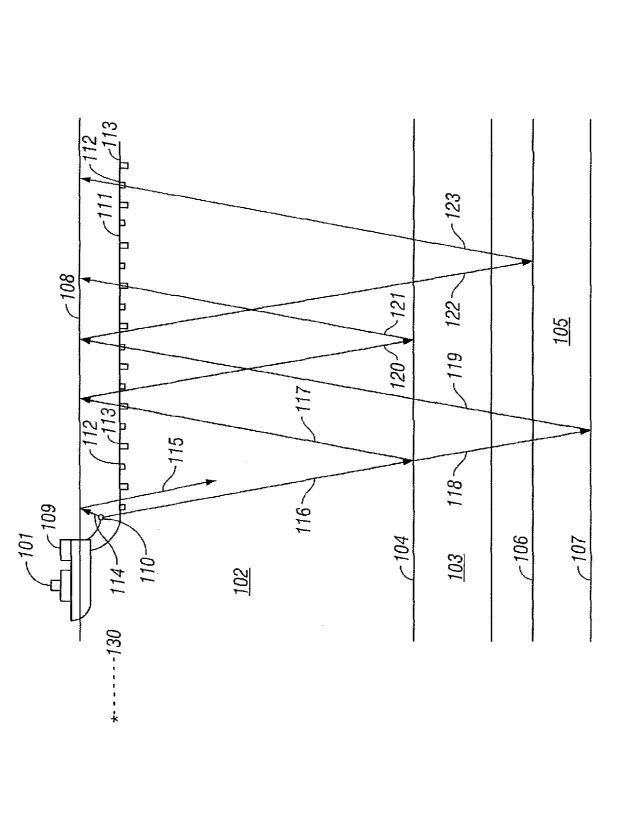
[0015] FIG. 1 shows an example of acquiring seismic data for use with a
method
according to the invention.
[0016] FIG. 2 shows a flow chart of an example method according to the
invention.
[0017] FIG. 3 shows a flow chart of an example method for using a
difference signal to
remove noise from a hydrophone signal.
Detailed Description
[0018] FIG. I shows an example of acquiring marine seismic data that can be
used
with the method of the invention. A seismic vessel 101 moves along the surface
108 of
a body of water 102 above a portion 103 of the subsurface that is to be
surveyed.
Beneath the water bottom 104, the portion 103 of the subsurface contains rock
4a
CA 02733220 2011-02-04
WO 2010/018189 PCT/EP2009/060424
formations of interest such as a layer 105 positioned between an upper
boundary 106
and lower boundary 107 thereof The seismic vessel 101 contains seismic
acquisition
control equipment, designated generally at 109. The seismic acquisition
control
equipment 109 includes navigation control, seismic energy source control,
seismic
sensor control, and signal recording equipment, all of which can be of types
well
known in the art.
[0019] The seismic acquisition control equipment 109 causes a seismic
source 110
towed in the body of water 102 by the seismic vessel 101 (or by a different
vessel) to
actuate at selected times. The seismic source 110 may be of any type well
known in
the art of seismic acquisition, including air guns or water guns, or
particularly, arrays
of air guns. Seismic streamers 111 are also towed in the body of water 102 by
the
seismic vessel 101 (or by a different vessel) to detect the acoustic
wavefields initiated
by the seismic source 110 and reflected from interfaces in the environment.
Although
only one seismic streamer 111 is shown in FIG. 1 for illustrative purposes,
typically a
plurality of laterally spaced apart seismic streamers 111 are towed behind the
seismic
vessel 101. The seismic streamers 111 contain sensors to detect the reflected
waveflelds initiated by the seismic source 110. In the present example the
seismic
streamers 111 contain pressure responsive sensors such as hydrophones 112, and
water particle motion responsive sensors such as geophones 113. The
hydrophones
112 and geophones 113 are typically co-located in pairs or pairs of sensor
arrays at
regular intervals along the seismic streamers 111. However, the type of
sensors 112,
113 and their particular locations along the seismic streamers 111 are not
intended to
be limitations on the present invention.
[0020] Each time the seismic source 110 is actuated, an acoustic wavefield
travels in
spherically expanding wave fronts. The propagation of the wave fronts will be
illustrated herein by ray paths which are perpendicular to the wave fronts. An
upwardly traveling wavefield, designated by ray path 114, will reflect off the
water-
air interface at the water surface 108 and then travel downwardly, as in ray
path 115,
where the wavefield may be detected by the hydrophones 112 and geophones 113
in
the seismic streamers 111. Such a reflection from the water surface 108, as in
ray
path 115 contains no useful information about the subsurface formations of
interest.
CA 02733220 2011-02-04
WO 2010/018189 PCT/EP2009/060424
However, such surface reflections, also known as ghosts, act as secondary
seismic
sources with a time delay from initiation of the seismic source 110.
[0021] The downwardly traveling wavefield, in ray path 116, will reflect
off the
earth-water interface at the water bottom 104 and then travel upwardly, as in
ray path
117, where the wavefield may be detected by the hydrophones 112 and geophones
113. Such a reflection at the water bottom 104, as in ray path 117, contains
information about the water bottom 104. Ray path 117 is an example of a
"primary"
reflection, that is, a reflection originating from a boundary in the
subsurface. The
downwardly traveling wavefield, as in ray path 116, may transmit through the
water
bottom 104 as in ray path 118, reflect off a layer boundary, such as 107, of a
layer,
such as 105, and then travel upwardly, as in ray path 119. The upwardly
traveling
wavefield, ray path 119, may then be detected by the hydrophones 112 and
geophones
113. Such a reflection off a layer boundary 107 contains useful information
about a
formation of interest 105 and is also an example of a primary reflection.
[0022] The acoustic wavefields will continue to reflect off interfaces
such as the
water bottom 104, water surface 108, and layer boundaries 106, 107 in
combinations.
For example, the upwardly traveling wavefield in ray path 117 will reflect off
the
water surface 108, continue traveling downwardly in ray path 120, may reflect
off the
water bottom 104, and continue traveling upwardly again in ray path 121, where
the
wavefield may be detected by the hydrophones 112 and geophones 113. Ray path
121 is an example of a multiple reflection, also called simply a "multiple",
having
multiple reflections from interfaces. Similarly, the upwardly traveling
wavefield in
ray path 119 will reflect off the water surface 108, continue traveling
downwardly in
ray path 122, may reflect off a layer boundary 106 and continue traveling
upwardly
again in ray path 123, where the wavefield may be detected by the hydrophones
112
and geophones 113. Ray path 123 is another example of a multiple reflection,
also
having multiple reflections in the subterranean earth.
[0023] Some of the seismic energy will travel essentially parallel to the
water surface
from the source 110 to the hydrophones 112 and geophones 113. In addition to
the
foregoing seismic energy, the hydrophones and geophones may detect noise
originating from places remote from the acquisition system, such as, for
example,
other seismic acquisition systems and drilling platforms in the water. Methods
6
CA 02733220 2011-02-04
WO 2010/018189 PCT/EP2009/060424
according to the invention are intended to attenuate such noise and the
foregoing
"direct" seismic energy. In FIG. 1, a noise source is shown generally at 130
and is
intended to represent any type of noise source that causes acoustic energy to
move
horizontally through the water.
[0024] For purposes of the following explanation, the terms "hydrophone"
and
"geophone" will be used as shorthand descriptions for the types of signals
being
processed. It is to be clearly understood that the term "hydrophone" in the
following
description is intended to mean a signal detected by any form of pressure
responsive
or pressure time gradient responsive sensor. Correspondingly, "geophone"
signals are
interned to mean a signal detected by any form of particle motion responsive
sensor,
including accelerometers, velocity meters and the like.
[0025] A method according to the invention begins using the recorded
hydrophone
and geophone signals corresponding to each actuation of the source. The
recordings
should be compensated for their respective sensor and recording channels'
impulse
responses and the transduction constant of each type of sensor used. Each such
record
of hydrophone and geophone recordings corresponding to a particular actuation
of the
source may be referred to as a "common shot" record or common shot "gather."
The
signal recordings may be indexed with respect to time of actuation of the
seismic
source, and may be identified by the geodetic position of each seismic sensor
at the
time of recording. The geophone signals may be normalized with respect to the
angle
of incidence of the seismic wavefront detected by each geophone. See, for
example,
U.S. Patent No. 7,359,283 issued to Vaage et al. and assigned to an affiliate
of the
assignee of the present invention for a description of such normalization. The
hydrophone response is substantially omni-directional and does not require
correction
or normalization for angle of incidence.
[0026] In a practical implementation of a method, the normalized common-
shot
records may then be transformed from the time-position domain into the
frequency-
wavenumber (f - k) domain. The resulting domain-transformed signals can be
expressed as:
H = P (1¨ Z)+ N si + PDA
Up
G = P (1+ Z)
Up
7
CA 02733220 2011-02-04
WO 2010/018189 PCT/EP2009/060424
(1)
where H represents the f - k transform of the hydrophone signals and G
represents the
f - k transform of the normalized geophone signals. Pup represents the upward
ly
propagating pressure wave field, Z represents the frequen cy-domain time delay
operator or exp(-icoT) in which i is the imaginary number Ai-1, co represents
the
angular frequency, and T represents the "ghost" reflection travel time from
the seismic
sensors to the water surface and back. Ns1 represents noise arriving
horizontally at the
seismic sensors. Such noise may be generated, for example by other seismic
vessels
operating in the area a relatively large distance from the acquisition system.
P DA
represents that portion of the seismic pressure wavefield traveling
horizontally from
the seismic source to the seismic sensors. The quantities (1 + Z) and (1 - Z)
represent
the geophone and hydrophone "ghosting" functions, respectively. The time delay
and
the respective ghosting functions can be determined if the depth of each
seismic
sensor in the water is known or determinable, as the velocity of seismic
energy in the
water is known or determinable. The present example includes transformation of
the
hydrophone and geophone signals into the frequency-wavenumber domain in
particular to facilitate calculating the geophone and hydrophone ghosting
functions. It
is to be understood that other implementations may process the signals other
than in
the frequency-wavenumber domain.
[0027] In a method according to the invention, the foregoing horizontally
traveling
noise and horizontally traveling seismic energy are to be attenuated from the
hydrophone signals. It may be assumed that Ns1 and P DA arrive essentially
horizontally at the hydrophones and geophones. If vertically oriented
geophones are
used in the streamers, such horizontally traveling signal components may be
assumed
to be substantially ab sent from the geophone signals. An example of a
streamer
including hydrophones and vertically oriented geophones is described in U.S.
Patent
No. 7,239,577 issued to Tenghamn et al. and assigned to an affiliate of the
assignee of
the present invention.
[0028] Applying the geophone ghosting function (1 + Z) to the hydrophone
signals
and applying the hydrophone ghosting function (1 ¨ Z) to the geophone signals
results
in the following expressions:
8
CA 02733220 2011-02-04
WO 2010/018189 PCT/EP2009/060424
(1 + Z)H = Pup(1¨ Z)(1+ Z)+ (1+ Z)[N sl + FDA]
(2)
(1¨ Z)G = P (1+ Z)(1¨ Z)
up
The signals resulting from application of the foregoing ghosting functions as
above
may be referred to as "cross ghosted" signals. The difference between the
foregoing
cross-ghosted signals may be represented by the expression:
(1+ Z)H ¨ (1¨ Z)G = (1+ Z)[N siDA (3)
P]
[0029] The foregoing difference ("difference signal") is equal to the
seismic
interference noise Ns1 and direct arrival signals P DA convolved with the
geophone
ghosting function (1 + Z). The foregoing contains essentially no seismic
signal
information, but contains the two foregoing types of noise. The foregoing
difference
function may be used to attenuate noise in the hydrophone signal or the
geophone
signal.
[0030] One example of such attenuation with respect to the hydrophone
signal is to
simply zero the hydrophone signal (replace the recorded amplitude value with
zero) at
every time sample where the amplitude of the corresponding time sample of the
difference signal is greater than that of the difference signal background
noise level.
The samples representing either of these two forms of noise typically
constitute only a
small number of the total samples on any recorded data trace, and therefore on
a trace
of the difference signal. In one example it is possible to compute the average
absolute
value of the samples in the difference-signal trace, represented by A, then
zero any
corresponding time samples in the hydrophone signal for difference signal
samples
whose absolute value is greater than a selected multiple of A, for example,
1.2 A (20%
greater than A). The foregoing operation would cause variable length "windows"
of
zero-value samples on the processed hydrophone signals. To smooth the
hydrophone
signals in such cases it is desirable to apply linear ramp functions to the
signal
samples before and after each such window. The length of such linear ramps
might
be on the order of 100 milliseconds.
[0031] As will be appreciated by those skilled in the art, the geophone
signals include
substantial noise resulting from towing the streamers in the water. In a
practical
implementation of a method according to the invention, tow noise may be
attenuated
by synthesizing the low-frequency part of the geophones' signal spectra, for
example,
9
CA 02733220 2011-02-04
WO 2010/018189 PCT/EP2009/060424
as described in U.S. Patent No. 7,359,283 issued to Vaage et al. and assigned
to an
affiliate of the assignee of the present invention.
[0032] To use such a technique to attenuate the effects of towing noise in
the
geophone signals, begin with the recorded common-shot domain hydrophone and
geophone signals, properly compensated for their respective sensor and
recording
channels' impulse responses and their transduction constants as explained
above. The
geophone signals should be corrected for their directional sensitivity as
explained
above. The common-shot records may then be transformed into the frequency-
wavenumber (f- k) domain. The resulting (f- k) domain transformed signals can
be
expressed as:
H = P (1¨ Z)+ N s, + Pa4
up
flow (4)
G = 1Pup (1+ Z)+ N
TOW
f ,0
[0033] in which corresponding variables represent the same parameters as
described
above in equations (1) through (3), and NTOW represents the towing induced
noise in
the geophone signals, essentially confined to frequencies between 0 and flow,
where
flow is typically about 20 Hz.
[0034] As described in the Vaage et al. patent referred to above, the tow
noise in the
geophone signals may be removed from the geophone signals G by estimating G's
spectrum for frequencies between 0 and flow. Such estimation may be performed
using the spectrum of the hydrophone signals H. The resulting f - k transform
of the
geophone signals having synthesized low frequency components, GIFC, may be
represented by the expression:
flow (1+ Z) f" pup (1+ Z)
G LFC = 1 H (1¨ Z) 1
f =0 f =flow
(5)
flow fnyq
Z)
G LFC = 1 [Pup (1¨ Z)+ N s, + Pal] (1+ Pup (1+ Z)
(1 ¨ Z) 1
f =0 f =flow
[0035] where fnyq represents the Nyquist frequency, that is, the highest
frequency
contained in the geophone and hydrophone signals. In the second expression
above
for GLFc, the expression for H has been substituted from the above expression
CA 02733220 2011-02-04
WO 2010/018189 PCT/EP2009/060424
[0036] Applying the geophone ghosting operator to H and the hydrophone
ghosting
operator to GLFC (cross ghosting) results in the expressions:
(1+ Z)H = P(1¨ Z)(1+ Z)+ (1+ Z)[N sl + PDA]
flow fnyq
(1 ¨ Z)G IT c =
1 []up (1 ¨ Z) N si
Pal](1 Z)
1 Pup
(1+ Z)(1¨ Z) (6)
f =0 f =flow
flow
(1¨ Z)G IT c = Pup (1 Z)(1 ¨ Z)
1 [N SI DA ](1 Z)
f ,0
[0037] Subtracting the cross-ghosted signals from each other provides the
expressions:
flow
(1 Z)H ¨ (1¨ Z)G LGC = (1+ Z)[N si Pal] ¨ 1 (1+ Z)[N si 'DA]
f ,0
fnyq (7)
(1 Z)H ¨ (1¨ Z)G LGc =
1 (1+ Z)[N si 'DA]
f =flow
[0038] Because the low-frequency portion of the geophone spectrum was
computed
from the hydrophone spectrum to eliminate the tow noise, the low-frequency
portion
of the geophone-ghosted seismic interference noise and direct arrivals are
essentially
absent from the above determined difference signal. However, the foregoing
difference signal can still be used to filter noise from the hydrophone and/or
geophone
signals, for example by zeroing the hydrophone traces at every time sample
therein
corresponding to a time sample in the difference signal having a magnitude
greater
than its background noise level. The background noise level may be calculated
as
explained above.
[0039] Although the foregoing example includes transformation of the
signals into the
frequency - wavenumber domain, such transformation is only for convenience. It
will
be appreciated by those skilled in the art that the foregoing process can be
performed
without the need to transform the signals into the frequency - wavenumber
domain.
[0040] An example of a method according to the invention is shown in a
flow chart in
FIG. 2. The hydrophone and geophone signals are shown as being acquired at
200.
The geophone signals may be normalized for angle of incidence at 202. At 204,
the
hydrophone signals may be used to synthesize the low frequency component of
the
geophone signals. The hydrophone and geophone signals may be transformed into
11
CA 02733220 2011-02-04
WO 2010/018189 PCT/EP2009/060424
the frequency-wavenumber domain. At 206, the transformed signals are cross-
ghosted. At 208, a difference between the cross ghosted signals is determined.
At
210, the difference signal is used to attenuate noise in the hydrophone
signal. In some
examples, to be used to attenuate noise in the hydrophone signal, the
difference signal
may be inverse transformed to the time position domain.
[0041] FIG. 3 shows a flow chart of an example of using the difference
signal to
attenuate noise in the hydrophone signal. At 300, an average A of the absolute
value
of the difference signal is determined. At 302, each sample A of the
difference signal
is compared to a selected multiple X of the average A. If the sample value
exceeds
the selected multiple of A, then the time corresponding sample in the
hydrophone
signal may be set to zero ("zeroed"). The foregoing may be repeated for each
hydrophone signal.
[0042] Methods according to the invention may provide improved attenuation
of
water borne noise in seismic signals. Methods according to the invention may
enable
seismic survey operations using multiple acquisition systems without the need
to
"time share" operation of seismic sources in such multiple systems, saving
time and
cost.
[0043] While the invention has been described with respect to a limited
number of
embodiments, those skilled in the art, having benefit of this disclosure, will
appreciate
that other embodiments can be devised which do not depart from the scope of
the
invention as disclosed herein. Accordingly, the scope of the invention should
be
limited only by the attached claims.
12