Note: Descriptions are shown in the official language in which they were submitted.
CA 02737205 2011-03-11
WO 2010/033716 PCT/US2009/057337
METHOD FOR OPTIMIZING WELL PRODUCTION IN
RESERVOIRS HAVING FLOW BARRIERS
1. CROSS-REFERENCE TO RELATED APPLICATIONS
This application claims priority to U.S. Provisional Application No.
61/098,609, filed
September 19, 2008, which is incorporated herein by reference in its entirety.
2. TECHNICAL FIELD
This document relates to systems and methods for optimizing hydrocarbon
recovery
from subsurface formations, including subsurface formations having bottom
water or
edgewater. This document also relates to systems and methods for optimizing
hydrocarbon
recovery in subsurface formations having flow barriers.
3. BACKGROUND
Conventional vertical wells can create severe coning problems in water drive
reservoirs, such as in thin bottom water reservoirs or edgewater reservoirs.
Bottom water
reservoirs are situated above an aquifer, and there can be a continuous
substantially
horizontal interface between the reservoir fluid and the aquifer water
(water/oil contact). In
an edgewater reservoir, only a portion of the reservoir fluid can be
substantially in contact
with the aquifer water (water/oil contact). Reservoir fluid, comprising
hydrocarbons such as
but not limited to oil, can be produced from these water drive reservoirs by
an expansion of
the underlying water and rock, which can force the reservoir fluid into a
wellbore. Coning
problems can arise because the actual rate of production can exceed the
critical rate where the
flat surface of water/oil contact begins to deform. Historically, wells
producing at critical
water-free rates can be less profitable. Horizontal wells have been used to
enhance oil
production from water drive reservoirs and are typically considered a better
alternative than
conventional vertical wells as they provide for better economics, improved oil
recovery and
higher development efficiency. Long horizontal wellbores are able to contact a
large
reservoir area such that for a given rate, horizontal wells require a lower
drawdown, resulting
in a less degree of coning/cresting.
-1-
CA 02737205 2011-03-11
WO 2010/033716 PCT/US2009/057337
Horizontal wells have been employed for enhancing oil recovery from reservoirs
having thin oil zones, generally ranging between five and twenty meters, with
strong bottom
water, such as those found in Bohai Bay of eastern China. To maximize oil
production and
avoid early water coning or cresting, horizontal wells can be placed near the
top of oil sand
bodies and wells can be produced with small pressure drawdown before water
breakthrough.
Nevertheless, the production responses from different horizontal wells can be
significantly
different from each other even though they are operated under similar
conditions. For
example, some wells can show premature water coning within a very short time
and rapid
water cut rising, while others can show later water breakthrough and steady
increase of water
cut for a longer time.
The existence of thin discontinuous low permeable or impermeable flow barriers
with
limited horizontal extension or continuity between the wellbore and water/oil
contact can
impact water coning characteristics. For example, the presence of a flow
barrier can be
beneficial, as the cumulative water production to produce the same amount of
oil can be less
and the time required to produce the same amount of oil can be shorter than
without the
barriers. Additionally, once water reaches the barrier, coning can be limited
because the
pressure drawdown caused by production can be less at the edge of the barriers
than at the
well in the absence of the barriers. In some instances, the effects of a
completely
impermeable barrier on the cone shape can be equivalent to extending the
wellbore out to the
radius of the barrier.
The productivity of vertical and horizontal wells in formations containing
discontinuous shales has been investigated using numerical simulation. For
single phase oil
flow, the discontinuous shale shows a decrease in the productivity index (or
PI) ratio between
horizontal and vertical wells. For two-phase oil/water flow in a bottom water
reservoir, the
randomly distributed discontinuous shales show an increased oil recovery by
decreasing
water cut in both horizontal and vertical wells (compared with wells without
shales). In other
words, shales typically shield the horizontal wells from the rising water
cone, resulting in
lower water cut values. In general, although the total well productivity
typically decreases
when shales are present, the productivity of oil increases due to the
sheltering effect of the
shale on water advancement. Accordingly, the long-term effects of
discontinuous shales
appear to be beneficial with respect to oil production.
The water/oil contact movement in a reservoir containing impermeable layers,
where
oil can be produced through a horizontal well, has also been investigated
using transparent
physical 2-D models. Results have shown that increased oil recovery can be
obtained when
-2-
CA 02737205 2011-03-11
WO 2010/033716 PCT/US2009/057337
the heel end of a long horizontal well is located above the upper layer of the
impermeable
streaks. Discontinuous impermeable layers or streaks in a bottom water
reservoir act as
obstacles to vertical reservoir flow or reduced vertical equivalent
permeability. This
condition can lead to delayed water breakthrough and significantly improved
oil production.
Oil production in heterogeneous cases has also shown to be better than in the
homogeneous
cases, such that they have delayed water breakthrough and slower water cut
increases.
Field data has shown that flow barriers benefit horizontal well performance.
For
example, horizontal wells have been known to produce oil almost one year
before the water
breakthrough. In light of this, others have suggested to place man-made
impermeable barriers
around the wellbore to stop the water cone/crest from forming. Others have
also suggested
using chemicals, such as a polymer, to partially plug bottom water zones in
order to improve
well production performance in bottom water reservoirs. Others have also
recommended
drilling long horizontal wells as far from the water/oil contact as possible
to improve well
performance. However, without the knowledge of physical locations and size of
flow
barriers, long-term production testing may be needed to obtain reliable pre-
development data
on the influence of these flow barriers.
4. SUMMARY
As disclosed herein, systems and methods are provided for optimizing
hydrocarbon
recovery from subsurface formations, including subsurface formations having
bottom water
or edgewater. Systems and methods also are provided for optimizing hydrocarbon
recovery
in subsurface formations having flow barriers.
For example, a system and method for identifying potential infill areas and
optimizing
well locations are provided, the method comprising: identifying by-pass oil
areas of the
subsurface formation using one or more reservoir simulations; identifying one
or more flow
barriers in the subsurface formation from well logs based on the by-pass oil
areas identified
by the one or more reservoir simulations; predicting the lateral extension of
the identified
flow barriers in the subsurface formation; placing one or more horizontal
infill wells at areas
of the subsurface formation that have high remaining oil saturation and such
that the one or
more flow barriers are positioned between the paths of the one or more
horizontal infill wells
and an area of contact between water and oil in the subsurface formation; and
placing at least
one horizontal well near the top of an oil column of the subsurface formation.
The horizontal
section can be drilled for as long as permitted by the well spacing. Producing
the horizontal
-3-
CA 02737205 2011-03-11
WO 2010/033716 PCT/US2009/057337
well with small drawdown can control the water coning. The liquid production
rate can be
increased when the water cut is high (e.g., 80-90%).
A system and method can be configured to: receive data indicative of physical
properties associated with materials in the subsurface formation and perform
one or more
computations and/or reservoir simulations for identifying "by-pass" oil areas.
A system and method can be used to identify and demonstrate the impact of flow
barriers on horizontal well performance. The sensitivity of different
parameters of flow
barriers on horizontal well performance can be identified.
A system and method provide for utilization of the sensitivity of different
parameters
of flow barriers on horizontal well performance in infill drilling
optimization to improve oil
production of infill wells. A workflow can be provided for infill drilling
that utilizes the
sensitivity of different parameters of flow barriers on horizontal well
performance in infill
drilling optimization to improve oil production of infill wells.
5. BRIEF DESCRIPTION OF THE DRAWINGS
Figures IA-C are schematic views of one realization of a reservoir model with
different proportion of flow barriers;
Figures 1D-F are schematic views of the cumulative oil production for the
realizations
in Figures IA-C;
Figures 2A-D are schematic views of one realization of a reservoir model with
different proportion of flow barriers;
Figures 2E-H are schematic views of the cumulative oil production for the
realizations
in Figures 2A-D;
Figure 3 is a schematic view of water cut curves;
Figure 4 is a schematic view of water cut curves and cumulative oil
production;
Figure 5 is a schematic view illustrating cross sections of permeability
models;
Figure 6 is a schematic view of cumulative oil production;
Figure 7A is a schematic view of flow barrier proportions;
Figure 7B is a schematic view of cumulative oil production;
Figure 7C is a schematic view of water cut;
Figures 8A-B are schematic views illustrating cross sections of permeability
models;
Figure 9 is a schematic view of flow barrier proportions;
Figure l0A is a schematic view of well locations;
-4-
CA 02737205 2011-03-11
WO 2010/033716 PCT/US2009/057337
Figure I OB is a schematic view illustrating cross sections of wells;
Figures 1 IA-B are schematic views of well production curves;
Figure 12 is a schematic view of well logs;
Figure 13A and 13B are schematic views of geological well models and water/oil
contacts;
Figure 13C and 13D are schematic views of history matching for the wells shown
in
Figures 13A and 13B;
Figures 14A and 14B are schematic views illustrating cross sections of wells;
Figures 14C and 14D are schematic views illustrating layers of permeability;
Figure 14E is a schematic view of low permeability layers;
Figures 15A and 15B are schematic views illustrating cross sections of well
water
saturation;
Figure 16 is a schematic view of production curves;
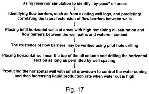
Figure 17 shows steps of a method for optimizing well production in reservoirs
having flow barriers;
Figure 18 is a block diagram of an example computer structure for use in
optimizing
the location of wells in a subsurface formation having flow barriers;
Figure 19 is a schematic view illustrating cross sections of wells having flow
barriers;
Figure 20 is a schematic view of well locations and a contour map of flow
barriers;
Figures 21A and 21B are schematic views of production curves;
Figures 22A and 22B are schematic views of production curves;
Figures 23 is a schematic view of a proposed pilot hole drilling, in
accordance with
the present invention;
Figures 24A - 24F are schematic views of production curves;
Figure 25 is a schematic view of production curves.
Figure 26 illustrates an example of a computer system for implementing one or
more
steps of the methods disclosed herein.
6. DETAILED DESCRIPTION
Systems and methods are provided for use in optimizing the location of
horizontal
wells in a subsurface formation having flow barriers for use in optimizing
hydrocarbon
recovery from the subsurface formation, including subsurface formations having
bottom
water or edgewater. It will be readily apparent to those skilled in the art
that description
-5-
CA 02737205 2011-03-11
WO 2010/033716 PCT/US2009/057337
herein in connection with bottom water reservoirs can also be applicable to
edgewater
reservoirs. A system and method can be configured to use data indicative of by-
pass oil areas
in the subsurface formation to optimize the location of horizontal wells. The
data can be
obtained from one or more reservoir simulations of the subsurface formation.
Flow barriers
in the subsurface formation can be identified from, e.g., well logs of the
subsurface formation
based on the by-pass oil areas identified by the reservoir simulations. The
well logs comprise
measurements (versus depth or time, or both) of one or more physical
quantities of materials
in or around a well. The systems and methods can be used to optimize
hydrocarbon recovery
from the subsurface formation when fluids comprising hydrocarbons are produced
from at
least one of the horizontal wells.
Given that water coning characteristics and thus the performance of horizontal
wells
in bottom water reservoirs or egdewater reservoirs can be difficult to
predict, high resolution
reservoir models explicitly representing flow barrier distributions can be
used. If they are not
employed, the impact on the flowing well behavior can vary significantly for
different
realizations of the simulated model. Higher resolution reservoir models can be
used to
define parameters that are used to represent the flow barriers accurately.
Some of these
parameters include, but are not limited to gravity contrast, mobility ratio,
vertical
permeability, permeability contrast of flow barrier to surrounding reservoir,
distance to
water/oil contact, length of horizontal well, dimensions and distribution of
flow barriers. The
computations or simulations disclosed herein can be performed by a reservoir
simulator or
other computation methods known in the art. The reservoir simulations
disclosed herein can
be performed on, e.g., a computer that can receive data indicative of physical
properties
associated with materials in the subsurface formation and perform one or more
reservoir
simulations for identifying "by-pass" oil areas. The "by-pass" oil areas may
arise, e.g., where
injected water or gas creates preferential flow-paths that by-pass oil in less
permeable
portions of the earth formation. For example, gas may by-pass into areas of
lower pressure.
Earth formation properties or parameters, such as the porosity and
permeability, may affect
the water flow-path, and result in "by-pass" oil areas. Also, the "by-pass"
oil area may arise
due to lack of existing producing wells exacting oil from this area, or lack
of injecting wells
pushing oil out of this area.
A synthetic single-well numerical model can be used to indicate the impacts of
reservoir geology on horizontal well performance, and more specifically on the
impacts of
flow barriers on horizontal well performance in thin strong bottom water drive
reservoirs.
The synthetic model has a grid of 60x60x32 with cell size of dx=dy=20m,
dz=0.5m for layer
-6-
CA 02737205 2011-03-11
WO 2010/033716 PCT/US2009/057337
1-31, and dz=10m for aquifer layer 32. The distribution of flow barriers can
be generated by
indicator simulation with the following control parameters: proportion of flow
barriers ranges
from 5-20%, lateral correlation length (X = ky) of flow barrier from 100-400m.
An
assumption of no vertical correlation can be made. A total of seven cases are
studied with
different flow barrier proportions, sizes and permeability contrast with the
background sands
(see Table 1).
Table 1
Proportion of Correlation length Permeability of
flow barriers of flow barriers flow barriers
Case 1 20% 200 m 10 and
Case 2 10% 200 m 10 and
Case 3 5% 200 m 10 and
Case 4 10% 400 m 10 and
Case 5 10% 100 m 10 and
Case 6 10% 200 m 1 and
Case 7 10% 200 m 20 and
Figures IA-C show one realization of the reservoir model generated with
different
proportions of flow barriers and the corresponding cumulative oil production
of 25 years
from 10 realizations of each case compared to the result from a model without
flow barriers.
Figure IA shows Case 1 having a 20% proportion of flow barriers, Figure lB
shows Case 2
having a 10% proportion of flow barriers, and Figure 1C shows Case 3 having a
5%
proportion of flow barriers. Figures 1D-F show the corresponding cumulative
oil production
respectively for each case. The permeabilities (k) of background sand are
assumed constant
with values of 2,000mD for all cases. Porosity and k lkh can be assumed to be
0.2 and 32%
for all cells. A horizontal well can be placed in the middle of the model at
layer 5 from the
top, which is about 12.5m above water/oil contact, and along the x-direction
with horizontal
section length of 680m. The bottom layer is an aquifer layer with strong
aquifer strength by
using a large porosity multiplier. Oil properties similar to that found in
reservoirs in eastern
China can be used: viscosity=22cp, API gravity = 25 degree.
The horizontal well is producing with a fixed liquid rate and the well
performance is
simulated for 10 realizations for each case using a commercial flow simulator.
Wellbore
-7-
CA 02737205 2011-03-11
WO 2010/033716 PCT/US2009/057337
friction can be accounted for during the simulation. Multiple realizations can
be used in
order to obtain more meaningful conclusions by accounting for the possible
spatial flow
barrier distributions. One skilled in the art will recognize that a large
number of realizations
may be required for an accurate invariant set of statistical data. Figures 1D-
F compare the 25
year cumulative oil production from the well to the case without flow
barriers.
Figures 2A-C show one realization of the reservoir model with different
correlation
length of flow barriers (400m and 100m), the predicted cumulative oil
production of 10
realizations, as well as the predictions with different permeability values of
flow barrier (lmd
and 20md). In particular, Figure 2A shows Case 4, Figure 2B shows Case 5,
Figure 2C
shows Case 6, and Figure 2D shows Case 7. Figures 2E-H show the corresponding
cumulative oil production respectively for each case. For all cases, the
existence of flow
barriers can significantly improve oil production of horizontal wells. More
specifically, as
seen in Figures IA-F, higher proportion of flow barriers yield higher
cumulative oil
production. Additionally as seen in Figures 2A-H, larger lateral extension of
flow barriers (in
terms of larger correlation length) yield better production performance, but
also with larger
variations in performance for different realizations. Furthermore, smaller
shale permeability
results in better production performance, but also with larger variation in
performance for
different realizations.
The existence of flow barriers increases water travel paths from aquifer to
horizontal
well, resulting in the slow down of water coning and increase of swept areas.
Variations of
performance from realization to realization can be relatively large when the
correlation length
of flow barriers or permeability contrast between flow barriers and background
sand is large.
This indicates high sensitivity of well performance on the spatial
distribution of some "key"
flow barriers relative to the well location. One skilled in the art will
recognize that the well
performance can change to worse if correlation length or proportion of flow
barriers becomes
too large (e.g., to a degree that might cause pressure communication problem).
Figure 3 shows the first year water cut curves of 10 realizations from Case 2,
which
will be used as the base case. The existence of flow barriers can either speed
up or slow down
the water breakthrough time depending on the realizations (i.e., spatial
distributions of flow
barriers with respect to the well paths). However, the subsequent rise in
water cut after water
breakthrough can be typically slower when there are flow barriers in the
model. The water cut
and cumulative oil production for the first year from a "good" and a "bad"
realization are
shown in Figure 4. A "good" realization can be defined as the one with longest
water
breakthrough time or in this case realization 4 of Figure 3. A "bad"
realization can be
-8-
CA 02737205 2011-03-11
WO 2010/033716 PCT/US2009/057337
defined as the one with shortest water breakthrough time or in this case
realization 6 of
Figure 3. The results in Figure 4 demonstrate that better oil production is
attainable for the
model with flow barriers even though water breakthrough could be significantly
faster,
mainly because of the slower rising of water cut from the models with flow
barriers than that
without flow barriers.
In order to further investigate the water cresting characteristics in the
models with and
without flow barriers, the variation of water saturation with time at the
areas underneath the
well path can be considered. Figure 5 shows cross sections of permeability
models, as well
as, distributions of water saturation at different times from realizations 4
and 6, which are
compared to those from the model without flow barriers. The different features
of water
cresting are apparent. For the model without flow barriers, early water coning
occurs for the
entire horizontal section, while for the models with flow barriers, water
breakthrough could
occur either much later in realization 6 or much earlier in realization 4. But
in both
circumstances, water coning occurs only at a small portion of the horizontal
section. Most
parts of horizontal well section do not experience water coning after a
considerably long
period of time. One skilled in the art will recognize that flow barriers can
practically shelter
some parts of the horizontal section from water advancement. This can explain
why the water
cut increase in the models with flow barriers can be slower than in the model
without flow
barriers even though water breakthrough may be quicker in the models with flow
barriers
than in the model without flow barriers. Thus, for bottom water reservoirs,
the water coning
characteristics of a horizontal well can be more likely similar to edge water
reservoirs when
there exist flow barriers. In addition, Figure 5 shows that the swept areas
between horizontal
section and water/oil contact are apparently bigger for models with flow
barriers than without
flow barriers. This might be due to the flow barriers acting as obstacles for
vertical flow
towards the wellbore, thus the streamlines of vertical flow can be detoured
around the flow
barriers resulting in sweeping a wider area. Figure 6 shows that the recovery
factor (or
cumulative oil production) can be higher for models with flow barriers than
without barriers.
The cumulative oil production after 25 years from a "bad" realization
(realization 4) is still
32% higher than the model without flow barriers, while a "good" realization
(realization 6) is
87% higher for cumulative oil production after 25 years.
For a given realization or model, the spatial distribution of flow barriers is
known and
the vertical proportion/fraction map of flow barriers can be computed. The
vertical
proportion/fraction map of flow barriers can be spatially varying. Examining
the correlation
between the production performance and proportion of flow barriers at well
locations, it can
-9-
CA 02737205 2011-03-11
WO 2010/033716 PCT/US2009/057337
be shown that a well would perform well if its horizontal section is placed in
the area where
flow barriers proportion between well path and water/oil contact is high. In
order to illustrate
this, the vertical proportion of flow barriers from layer 6 (horizontal well
is placed at layer 5
in our model) to layer 31 (below which water/oil contact is located) for
realization 3 of Case
2 is computed. The result is shown in Figure 7A. The grey scale in a given (i,
j) cell of this
figure indicates the value of vertical proportion of flow barrier computed
from the 26 layers
(from layer 6 to 31) of the same (i, j) cell. For example, at the upper left
corner cell (1, 1),
flow barriers are found in only 1 layer from the 26 layers (from layer 6 to
31), thus the
vertical proportion of flow barrier in cell (1, 1) is 1/26=0.04. The original
horizontal well is
placed in the middle of this model (the solid line) where the proportion of
flow barriers is
relatively small, particularly in the heel (left) side. This can lead to
relatively poor production
performance with only 54% increase for cumulative oil production compared to
the model
without flow barriers. The horizontal well upper left is moved to the location
indicated by the
dash line and the well performance is recomputed. The results are shown in
Figures 7B and
7C, where it can be seen that the production performance of newly located well
can be
significantly better than the original well location with 140% increase of oil
production over
25 years compared to the model without flow barriers.
Figures 8A-B show the cross sections of permeability and water saturation at
different
time which reveals the beneficial impact by moving the well location from the
original place
(Figure 8A) to a new location (Figure 8B). More flow barriers can be seen in
the cross section
of new well location than in that of original well location, which can result
in much later
water breakthrough, slower water cut increase, and higher oil production from
the new well.
Similar effects are obtained for realizations 6 and 7 by moving the well
location to new
places as indicated in Figure 9. For the both models, the cumulative oil
productions over 25
years from the original wells are about 40% more than that from the model
without flow
barriers, while the wells at new locations produce 90% more oil compared to
the model
without flow barriers.
In view of the foregoing, well locations can be optimized using the vertical
proportion
map of flow barrier or, in other words, to place the well at the area with a
higher proportion
of flow barriers. As for the vertical direction, the horizontal section can be
placed as far from
the water/oil contact as possible so that there are more chances of
encountering flow barriers
and higher stand-off distance from the water/oil contact. The optimal
normalized stand-off,
z/h, where z is the stand-off distance and h is the total oil column height
from reservoir top to
water/oil contact, can be in the range of 0.7-0.9. Furthermore, it may be
advantageous to drill
-10-
CA 02737205 2011-03-11
WO 2010/033716 PCT/US2009/057337
long horizontal wells to gain more contact areas as the pressure drop along
the wellbore can
be small for the given wellhole size and production rate used in the
simulations.
Regarding field verification of the effect of flow barriers effect on well
production,
the following are discussed. The reservoir geology and the flow barriers can
impact the
production performance and water cresting characteristics of horizontal wells
in bottom water
reservoirs. The existence of discontinuous flow barriers improves the
production performance
of horizontal wells by delaying the water breakthrough and slowing down the
water cut
rising. Part of the horizontal section can be shielded from rising water crest
by flow barriers,
while water cresting can occur to the entire horizontal well when there is no
flow barrier.
As an example, the geological characteristics and production performance of
two
horizontal wells from an oil field in Bohai Bay, China are investigated. The
reservoir depth
for a first producing formation, Field 1, ranges from 1000m to 1400m. A second
producing
formation, Field 2, is at the depth of 1450-1900m. Field 1 formation is
comprised of fluvial
depositional reservoirs with meandering channels, multiple sand systems and
complex
oil/water systems, while Field 2 is a fluvial sand deposition with braided
channels and strong
bottom water, the oil column height ranges from 10-30m. Two horizontal wells,
Well A and
Well B, are drilled in Field 2 formation to test the development efficiency of
such reservoir
using horizontal wells. Both wells are drilled at structure top locations with
very similar
geological conditions, as shown in Figures l0A-B. The horizontal lengths for
the two wells
are 713m for Well A and 999m for Well B, respectively. The oil column heights
(from
horizontal section to water/oil contact) are 1 lm for Well A and 16m for Well
B. After
completion, both wells are operated with similar conditions, that is, similar
initial production
rate and similar small pressure drawdown. It is thus expected that both wells
would have
similar production performance. However, the two wells displayed quite
different production
performance. Well A displayed unstable production at early stage with quick
water
breakthrough in less than 3 months. In addition, the water cut increased
rapidly after water
breakthrough reaching 90% in less than one year. Oil production declined from
about
200m3/day to around 30m3/day within one year, as shown in Figure 1 IA. These
are the
typical production characteristics of a horizontal well in thin bottom water
reservoirs.
Production from Well B is stable and free of water for more than 8 months. The
water cut
increased gradually after water breakthrough staying less than 50% for 3
years, as shown in
Figure 11 B. The production performance of Well B does not display the
characteristics of a
typical bottom water reservoir, rather than a typical edge water reservoir.
-11-
CA 02737205 2011-03-11
WO 2010/033716 PCT/US2009/057337
A study of reservoir characteristics in areas around the two wells, to
understand the
drastic production performance difference of the two wells, revealed the
existence of thin low
permeable flow barriers. As described previously herein, thin low permeable
flow barriers
with limited horizontal extension/continuity between the wellbore and
water/oil contact can
impact the water coning characteristics. Accordingly, wells with such flow
barriers can
display later water breakthrough with steady increase of water cut after
breakthrough, such as
Well B, while wells without such barriers can display quick water coning with
water cut
reaching more than 90% rapidly, such as Well A.
To further understand the different production performance in Well A and Well
B,
two nearby appraisal wells, Well C and Well D, are considered. The locations
of Well C and
Well D are shown in Figure I OB, such that Well D is close to Well A, while
Well C is close
to Well B. Figure 12 shows the logs of these two wells, the gamma ray and
permeabilities in
Well D are more or less uniform indicating clean sand with high permeability,
while in Well
C, two low permeability zones can be identified indicating the possible
existence of low
permeability flow barriers. The reservoir model of Field 2 formation is then
constructed and
history matched by methods commonly known in the art. Figures 13A-D show the
reservoir
model, water/oil contact and matched well performance for Well A and Well B.
The
matching of production history in both wells is excellent without significant
changes to the
original geological model. The permeability distributions of cross sections at
Well A and
Well B areas from the history matched model are shown in Figures 14A and 14B.
In Figures
14C and 14D the layers with permeability smaller than a threshold value of
29.5mD (which is
about I% of the average permeability in Field 2 formation) in the two areas
can be seen.
There exist some low permeable flow barriers between Well B and water/oil
contact, while
no flow barrier displays in the area between Well A and water/oil contact. In
Figure 14E, the
spatial (lateral) extension of some major low permeable layers in Well B area
is shown such
that the majority of the horizontal section of Well B is well-shielded by
several layers of flow
barriers and water breakthrough is likely occurring mainly at the section near
the heel where
only one layer of flow barrier with limited lateral extension is found.
Figures 15A and 15B
shows the cross sections of water saturation calculated in the areas of the
two wells. For Well
A, water cresting did occur for the entire horizontal section, while in Well
B, water coning
occurred only at a small portion of the horizontal well section near the heel
part. The
existence of a significant number of low permeability flow barriers in Well B
area ensures the
good production performance in Well B with late water breakthrough and slow
increase of
water cut after breakthrough (water coning occurs only at small portion of
horizontal section).
-12-
CA 02737205 2011-03-11
WO 2010/033716 PCT/US2009/057337
While the poor production performance in Well A is mainly due to the clean
sand distribution
in Well A area resulting in early water breakthrough and fast increase of
water cut (water
cresting occurs at the entire horizontal section). Therefore, the field data
and simulation
results in Field 2 formation further verify the difference in production
performance between
Well A and Well B. One skilled in the art will recognize that some other
factors may also
contribute to the performance differences of the two wells, such as distance
from the
water/oil contact, horizontal well length and producing pressure drawdown.
An optimization method is discussed for optimizing horizontal well locations.
To
fully utilize flow barriers, the spatial distribution of such thin and
spatially discontinuous
flow barriers can be identified. This can be challenging since thin flow
barriers usually can
be at sub-seismic scale and thus difficult to characterize before many wells
have been drilled.
Therefore, long term production tests are helpful to obtain reliable pre-
development data on
the influence of discontinuous flow barriers for the development of a new or
green field. For
infill drilling of a mature field where many wells (such as vertical wells)
are drilled, it is
possible to predict/correlate/characterize the spatial distribution of thin
flow barriers from the
logs of existing wells. Optimization of horizontal well locations can be
performed to make
full use of the flow barriers and thus improve production of fluids.
Infill drilling optimization is utilized at Field 1 and Field 2 formations in
the west area
of the oil field in Bohai Bay, China. The Field 1 formation in the west area
is shallower than
the Field 2 formation. The main pay sand layer is a bottom/edge water
reservoir with oil
column of 10-20m. Oil in Field 1 formation is heavier than in Field 2
formation with
viscosity of 260cp and API gravity of 15-17 degree. Originally, 21 vertical
wells were drilled
to develop this area and the resulting production performance was poor because
of severe
water coning problems. Water cut reached 50% in less than one month and
current water cut
is about 90%, as shown in Figure 16. Horizontal infill wells can be drilled in
this area to
improve the production.
The following method, also shown in Figure 17, can be used to identify
potential infill
areas and optimize well locations:
(a) using reservoir simulation to identify "by-pass" oil areas;
(b) identifying thin flow barriers (such as, but not limited to, from existing
well logs)
and predicting/correlating the lateral extension of flow barriers between
wells;
(c) placing infill horizontal wells at areas with high remaining oil
saturation and flow
barriers between the well paths and water/oil contact;
(d) using pilot hole drilling to verify the existence of flow barriers if
necessary;
-13-
CA 02737205 2011-03-11
WO 2010/033716 PCT/US2009/057337
(e) placing horizontal well near the top of the oil column and drilling the
horizontal
section as long as permitted by the well spacing; and
(f) producing the horizontal well with small drawdown to control the water
coning
and then increase liquid production rate when water cut is high (e.g., 80-
90%).
Figure 18 depicts a block diagram of an example system for use in optimizing
the
location of wells in a subsurface formation having flow barriers and bottom
water (which can
also be applicable to an edgewater reservoir). The system can comprise a well
location
optimization module 2 for performing the processes discussed herein. In the
practice of the
system and method, data indicative of by-pass oil areas in the subsurface
formation is
received at process 4 (such as from a reservoir simulation 8), one or more
flow barriers in the
subsurface formation are identified based on the by-pass oil areas identified
by the reservoir
simulation at process 6, and the lateral extension of the identified flow
barriers in the
subsurface formation are predicted at process 10. The reservoir simulation can
receive data
indicative of physical properties of materials in the subsurface formation 12
to compute the
data indicative of by-pass oil. As shown at process 11 the practice of the
system and method
can also comprise determining the placement of one or more horizontal infill
wells at areas of
the subsurface formation based on the predicted lateral extension, and
determining placement
of at least one horizontal well relative to an oil column of the subsurface
formation based on
placement of the one or more horizontal infill wells.
The result of the well location optimization can be, but is not limited to,
one or more
parameters that indicate the location of the one or more horizontal infill
wells and/or at least
one horizontal well that can provide optimized hydrocarbon recovery from the
subsurface
formation when fluids, comprising the hydrocarbons, are produced from the at
least one
horizontal well in the subsurface formation.
The solution or result 14 of the well location optimization can be displayed
or output
to various components, including but not limited to, a user interface device,
a computer
readable storage medium, a monitor, a local computer, or a computer that is
part of a
network.
Figure 19 shows two cross sections in the west area and the correlation
analysis of
different pay sand layers, as well as the flow barriers. Three main flow
barriers are identified
and the lateral extension of these flow barriers is predicted. Two horizontal
wells (Well E
and Well F) are drilled as a pilot test of infill drilling as shown in Figure
20. Well E is drilled
at 21.5m from the water/oil contact (the total oil column height is 27m) with
horizontal
section length of 312m. Well F is drilled at 21.7m from the water/oil contact
(the total oil
-14-
CA 02737205 2011-03-11
WO 2010/033716 PCT/US2009/057337
column height is 25m) with horizontal section length of 313m. The production
performance
of these two wells is very positive, as shown in Figures 21A-B. Well E
produces almost free
of water for about one year, and then water cut increases gradually. Current
cumulative oil
production reaches 27,000m3. Well F produces pure oil for more than two years,
and then
with gradual increase of water cut. The current cumulative oil production from
Well F
reaches 28,500 m3. Both wells display the desired production behaviors similar
to Well B,
that is, late water breakthrough and particularly slow increase of water cut
after breakthrough.
After the successful production in the two pilot horizontal infill wells, two
more
horizontal wells, Well G and Well H, are drilled in Field 2 formation near
Well B area, as
shown in Figure 10A. Additionally, another six wells, Wells I - N, are drilled
in Field 1
formation as shown in Figure 20. The wells are placed above interpreted
potential flow
barriers with distance of horizontal section to water/oil contact ranging from
11-22m and
length of horizontal section of 170-650m. The production curves of Well G and
Well H are
shown in Figures 22A-B, which again illustrate good performance behaviors with
late water
breakthrough and slow increase of water cut. Well H has produced free of water
since the
beginning.
The flow barrier distribution in the proposed Well J area can be uncertain. To
reduce
the uncertainty on the existence of flow barriers, a pilot hole can drilled
before the horizontal
section to check if the predicted flow barrier exists. Figure 23 shows the
interpretation results
from the well log of the pilot hole which verifies the existence of flow
barrier. Then Well J is
drilled as originally designed. Figures 24A-F show the production performances
of all six
newly drilled infill wells. Initial production from these wells shows good
performance,
except for Well N where water production can be unexpectedly large right after
the
production started. Such behavior could have been caused by reasons other than
reservoirs.
The infill drilling program in the west area of the oil field in Bohai Bay,
China is shown to be
very successful. This demonstrates that the methods of the present invention
focusing on the
distribution of flow barrier can be appropriate for strong bottom water drive
reservoirs.
Current production from the 8 infill horizontal wells accounts for almost 50%
of total current
oil production in Field 1 formation in the west area of the oil field, as
shown in Figure 25.
Following are examples of results of use of the optimization method. The
production
responses from different wells can display significant variations even though
they are
operated under similar conditions. Some wells show premature water coning and
rapid water
cut rising although high quality sands are targeted, while others show much
delayed water
breakthrough and slower water cut increases. A series of reservoir simulations
can be
-15-
CA 02737205 2011-03-11
WO 2010/033716 PCT/US2009/057337
conducted to investigate the observed differences. The simulation results show
that the
existence of thin low permeable flow barriers with limited lateral
extension/continuity
between the wellbore and water/oil contact plays a role that impacts the water
coning
characteristics. Wells with such flow barriers display later water
breakthrough with steady
increase of water cut after breakthrough, while wells without such barriers
show quick water
coning with water cut reaching more than 90% rapidly. The existence of low
permeability
barriers between the water/oil contact and horizontal wells may slow down
water coning and
result in favorable production performance. This phenomenon is verified by
simulations and
actual field data from an oil field in Bohai Bay, China. The accurate
predictions of
production performance use knowledge of physical distribution of flow barriers
relative to the
wellbore location. In practice, lateral thin flow barriers are usually at sub-
seismic scales, and
thus hard to identify for a green field. However, for infill drilling in
mature fields with many
vertical wells drilled, it is possible to predict/correlate the spatial
distribution of such flow
barriers from the logs of existing wells. Based on such analysis, the
locations of horizontal
infill wells can be optimized to make full use of the flow barriers for
improving production.
Long horizontal wells can be drilled as close to the top of the oil zone as
possible for
developing thin bottom water reservoirs. The existence of low permeability
flow barriers can
improve the production performance of horizontal well in bottom water drive
reservoir. The
advantages of flow barriers include delaying water breakthrough, slowing water
cut rising,
and increasing swept area. Optimization of horizontal well placement with
respect to the
distribution of flow barriers could add value for reservoir systems with flow
barriers. High
resolution reservoir models can be used to simulate the impact of thin flow
barriers in the
system.
6.1 Apparatus and Computer-Program Implementations
One or more steps of the methods disclosed herein can be implemented using an
apparatus, e.g., a computer system, such as the computer system described in
this section,
according to the following programs and methods. Such a computer system can
also store
and manipulate, e.g., data indicative of physical properties associated with
materials in the
subsurface formation, reservoir simulations for identifying "by-pass" oil
areas, or
measurements that can be used by a computer system implemented with steps of
the methods
described herein. The systems and methods may be implemented on various types
of
computer architectures, such as for example on a single general purpose
computer, or a
-16-
CA 02737205 2011-03-11
WO 2010/033716 PCT/US2009/057337
parallel processing computer system, or a workstation, or on a networked
system (e.g., a
client-server configuration such as shown in Figure 26).
As shown in Figure 26, the modeling computer system to implement one or more
methods and systems disclosed herein can be linked to a network link which can
be, e.g., part
of a local area network ("LAN") to other, local computer systems and/or part
of a wide area
network ("WAN"), such as the Internet, that is connected to other, remote
computer systems.
The system comprises any simulation or computer-implemented step of the
methods
described herein. For example, a software component can include programs that
cause one or
more processors to implement steps of accepting a plurality of parameters
indicative of
physical properties associated with materials in the subsurface formation,
and/or parameters
of reservoir simulations for identifying "by-pass" oil areas, and storing the
parameters
indicative of physical properties associated with materials in the subsurface
formation, and/or
parameters of reservoir simulations for identifying "by-pass" oil areas in the
memory. For
example, the system can accept commands for receiving parameters indicative of
physical
properties associated with materials in the subsurface formation, and/or
parameters of
reservoir simulations for identifying "by-pass" oil areas, that are manually
entered by a user
(e.g., by means of the user interface). The programs can cause the system to
retrieve
parameters indicative of physical properties associated with materials in the
subsurface
formation, and/or parameters of reservoir simulations for identifying "by-
pass" oil areas,
from a data store (e.g., a database). Such a data store can be stored on a
mass storage (e.g., a
hard drive) or other computer readable medium and loaded into the memory of
the computer,
or the data store can be accessed by the computer system by means of the
network.
7. REFERENCES CITED
All references cited herein are incorporated herein by reference in their
entirety and
for all purposes to the same extent as if each individual publication or
patent or patent
application was specifically and individually indicated to be incorporated by
reference in its
entirety herein for all purposes. Discussion or citation of a reference herein
will not be
construed as an admission that such reference is prior art to the present
invention.
8. MODIFICATIONS
Many modifications and variations of this invention can be made without
departing
from its spirit and scope, as will be apparent to those skilled in the art.
The specific
-17-
CA 02737205 2011-03-11
WO 2010/033716 PCT/US2009/057337
embodiments described herein are offered by way of example only, and the
invention is to be
limited only by the terms of the claims, along with the full scope of
equivalents to which such
claims are entitled.
As an illustration of the wide scope of the systems and methods described
herein, the
systems and methods described herein may be implemented on many different
types of
processing devices by program code comprising program instructions that are
executable by
the device processing subsystem. The software program instructions may include
source
code, object code, machine code, or any other stored data that is operable to
cause a
processing system to perform the methods and operations described herein.
Other
implementations may also be used, however, such as firmware or even
appropriately
designed hardware configured to carry out the methods and systems described
herein.
The systems' and methods' data (e.g., associations, mappings, data input, data
output,
intermediate data results, final data results, etc.) may be stored and
implemented in one or
more different types of computer-implemented data stores, such as different
types of storage
devices and programming constructs (e.g., RAM, ROM, Flash memory, flat files,
databases,
programming data structures, programming variables, IF-THEN (or similar type)
statement
constructs, etc.). It is noted that data structures describe formats for use
in organizing and
storing data in databases, programs, memory, or other computer-readable media
for use by a
computer program.
The systems and methods may be provided on many different types of computer-
readable media including computer storage mechanisms (e.g., CD-ROM, diskette,
RAM,
flash memory, computer's hard drive, etc.) that contain instructions (e.g.,
software) for use in
execution by a processor to perform the methods' operations and implement the
systems
described herein.
The computer components, software modules, functions, data stores and data
structures described herein may be connected directly or indirectly to each
other in order to
allow the flow of data needed for their operations. It is also noted that a
module or processor
includes but is not limited to a unit of code that performs a software
operation, and can be
implemented for example as a subroutine unit of code, or as a software
function unit of code,
or as an object (as in an object-oriented paradigm), or as an applet, or in a
computer script
language, or as another type of computer code. The software components and/or
functionality may be located on a single computer or distributed across
multiple computers
depending upon the situation at hand.
-18-