Note: Descriptions are shown in the official language in which they were submitted.
CA 02741011 2011-04-18
WO 2010/047885 PCT/US2009/055793
METHOD FOR DETERMINING ELECTROMAGNETIC
SURVEY SENSOR ORIENTATION
TECHNICAL FIELD
[00011 The invention relates generally to the field of electromagnetic
geophysical
surveying. More specifically, the invention relates to methods for accurately
determining
the orientation of electromagnetic sensors deployed to perform such surveying.
BACKGROUND
[00021 Electromagnetic survey systems and methods provide a variety of data
about subsurface formations; including, for example, the spatial distribution
of resistivity
in the Earth's subsurface. Such data are interpreted and evaluated, among
other purposes,
to improve prediction of oil and gas production from a given reservoir or
field, to detect
new oil and gas reservoirs, to provide a picture or model of subsurface
formations and of
reservoirs in order to facilitate the removal of hydrocarbons, and/or to
reduce the risk or
otherwise enhance the process of well location.
[00031 Controlled source electromagnetic ("CSEM") surveying includes imparting
an electric current or a magnetic field into subsurface Earth formations
(through the sea
floor in marine surveying or through the borehole fluid in borehole
surveying), and
measuring voltages and/or magnetic fields induced in electrodes, antennas
and/or
magnetometers disposed near the Earth's surface, on the sea floor, or in a
borehole. The
voltages and/or magnetic fields are induced in response to the electric
current and/or
magnetic field imparted into the Earth's subsurface, and the recorded signal
is interpreted
in terms of distributions of resistivity, induced polarization, etc, within
the earth.
[00041 Controlled source surveying, as known in the art, typically includes
imparting continuous, alternating electric current into the subsurface. The
alternating
current may have one or more selected frequencies. Such surveying is known as
frequency domain controlled source electromagnetic (f-CSEM) surveying. f-CSEM
surveying techniques are described, for example, in Sinha, M.C. Patel, P.D.,
Unsworth,
M.J., Owen, T.R.E., and MacCormack, M.G.R., 1990, An active source
electromagnetic
sounding system for marine use, Marine Geophysical Research, 12, 29-68. Other
publications which describe the physics of and the interpretation of
electromagnetic
1
CA 02741011 2011-04-18
WO 2010/047885 PCT/US2009/055793
subsurface surveying include: Edwards, R.N., Law, L.K., Wolfgram, P.A., Nobes,
D.C.,
Bone, M.N., Trigg, D.F., and DeLaurier, J.M., 1985, First results of the MOSES
experiment: Sea sediment conductivity and thickness determination, Bute Inlet,
British
Columbia, by magnetometric offshore electrical sounding: Geophysics 50, No. 1,
153-
160; Edwards, R.N., 1997, On the resource evaluation of marine gas hydrate
deposits
using the sea floor transient electric dipole-dipole method: Geophysics, 62,
No. 1, 63-74;
Chave, A.D., Constable, S.C. and Edwards, R.N., 1991, Electrical exploration
methods for
the seafloor: Investigation in geophysics No 3, Electromagnetic methods in
applied
geophysics, vol. 2, application, part B, 931-966; and Cheesman, S.J., Edwards,
R.N., and
Chave, A.D., 1987, On the theory of sea floor conductivity mapping using
transient
electromagnetic systems: Geophysics, 52, No. 2, 204-217. Typical borehole-
related
applications are described in Strack (US Patents No. 6,541,975 B2, 6,670,813,
and
6,739,165) and Hanstein et al., (U.S. Patent No. 6,891,376). The proposed
methodology is
not limited to such applications , as it is more general than these specific
contexts .
[0005] Another technique for electromagnetic surveying of subsurface Earth
formations known in the art is transient controlled source electromagnetic
surveying (t-
CSEMTM). In t-CSEM, electric current is imparted into the Earth at the Earth's
surface, in
a manner similar to f-CSEM, but in transient fashion. The initial electric
current may be
direct current (DC). At a selected time, the electric current is switched off,
and induced
voltages and/or magnetic fields are measured, typically with respect to time
over a
selected time interval, at the Earth's surface. The switching constitutes the
transient event
that gives the technique its name; in contrast with certain realizations of f-
CSEM (which
also involve switching), in t-CSEM a long time interval elapses before the
next transient is
initiated, long enough for the induced fields to decay away, so that the
detection occurs
while the source is inactive. The electrical structure of the subsurface is
inferred by the
time distribution of the induced voltages and/or magnetic fields. t-CSEM
techniques are
described, for example, in Strack, K.-M., 1992, Exploration with deep
transient
electromagnetics, Elsevier, 373 pp. (reprinted 1999).
[0006] Following are described several patent publications which describe
various
aspects of electromagnetic subsurface Earth surveying. U.S. Patent No.
6,603,313 B1
issued to Srnka discloses a method for surface estimation of reservoir
properties, in which
location of and average earth resistivities above, below, and horizontally
adjacent to
2
CA 02741011 2011-04-18
WO 2010/047885 PCT/US2009/055793
subsurface geologic formations are first determined using geological and
geophysical data
in the vicinity of the subsurface geologic formation. Then dimensions and
probing
frequency for an electromagnetic source are determined to substantially
maximize
transmitted vertical and horizontal electric currents at the subsurface
geologic formation,
using the location and the average earth resistivities. Next, an
electromagnetic source is
activated at or near surface, approximately centered above the subsurface
geologic
formation and a plurality of components of electromagnetic response is
measured with a
receiver array. Geometrical and electrical parameter constraints are
determined, using the
geological and geophysical data. Finally, the electromagnetic response is
processed using
the geometrical and electrical parameter constraints to produce inverted
vertical and
horizontal resistivity depth images. Optionally, the inverted resistivity
depth images may
be combined with the geological and geophysical data to estimate the reservoir
fluid and
shaliness properties. This method employs a simple technique for determining
the
orientations of the receivers, which is improved upon with the present
invention.
[00071 U.S. Patent No. 6,628,110 BI issued to Eidesmo et al. discloses a
method
for determining the nature of a subterranean reservoir whose approximate
geometry and
location are known. The disclosed method includes: applying a time varying
electromagnetic field to the strata containing the reservoir; detecting the
electromagnetic
wave field response; and analyzing the effects on the characteristics of the
detected field
that have been caused by the reservoir, thereby determining the content of the
reservoir,
based on the analysis. This method employs a simple technique for determining
the
orientations of the receivers, which is improved upon with the present
invention.
[00081 U.S. Patent No. 6,541,975 B2 and U.S. Patent No. 6,670,813 issued to
Strack disclose a system for generating an image of an Earth formation
surrounding a
borehole penetrating the formation. Resistivity of the formation is measured
using a DC
measurement, and conductivity and resistivity of the formations is measured
with a time
domain signal or AC measurement. The acoustic velocity of the formation is
also
measured. The DC resistivity measurement, the conductivity measurement made
with a
time domain electromagnetic signal, the resistivity measurement made with a
time domain
electromagnetic signal and the acoustic velocity measurements are combined to
generate
the image of the Earth formation. In this method, the orientation of the
receivers is
3
CA 02741011 2011-04-18
WO 2010/047885 PCT/US2009/055793
determined using conventional borehole methods, and the present invention is
not
applicable to this context.
[00091 U.S. Patent No. 6,739,165 issued to Strack discloses a method where
transient electromagnetic measurements are performed with a receiver or
transmitter being
placed in a borehole and the other being placed on the surface. Either is
moved between
initiations of the transient source (and the consequent transmission of EM
energy with the
earth) to new locations where the experiment is repeated. After data
processing, images of
fluid content changes of the reservoir are obtained. This method employs a
simple
technique for determining the orientations of the surface receivers, which is
improved
upon with the present invention.
[00101 International Patent Application Publication No. WO 0157555 Al
discloses
a system for detecting a subterranean reservoir or determining the nature of a
subterranean
reservoir whose position and geometry is known from previous seismic surveys.
An
electromagnetic field is applied by a transmitter on the seabed and is
detected by antennae
also on the seabed. A refracted wave component is sought in the wave field
response, to
determine the nature of any reservoir present. This method employs a simple
technique for
determining the orientations of the receivers, which is improved upon with the
present
invention.
[00111 International Patent Application Publication No. WO 03048812 Al
discloses an electromagnetic survey method for surveying an area previously
identified as
potentially containing a subsea hydrocarbon reservoir. The method includes
obtaining
first and second survey data sets with an electromagnetic source aligned end-
on and
broadside relative to the positions of the same or different receivers. The
invention also
relates to planning a survey using this method, and to analysis of survey data
taken in
combination, which allows the galvanic contribution to the signals collected
at the receiver
to be contrasted with the inductive effects, and the analysis of the effects
of signal
attenuation, which are highly dependent on local properties of the rock
formation,
overlying water, and air at the survey area. This is very important to the
success of using
electromagnetic surveying for identifying hydrocarbon reserves and
distinguishing them
from other classes of subsurface structure. This method employs a simple
technique for
determining the orientations of the receivers, which is improved upon with the
present
invention.
4
CA 02741011 2011-04-18
WO 2010/047885 PCT/US2009/055793
[00121 U.S. Patent Application Publication No. 2004/232917 filed by Wright et
al.
relates to a method of mapping subsurface resistivity contrasts by making
multichannel
transient electromagnetic (MTEM) measurements on or near the Earth's surface
using at
least one source, means for measuring the system response, and at least one
receiver for
measuring the resultant earth response. All signals from the or each source-
receiver pair
are processed to recover the corresponding electromagnetic impulse response of
the earth
and such impulse responses, or any transformation of such impulse responses,
are
displayed to create a subsurface representation of resistivity contrasts. The
system and
method enable subsurface fluid deposits to be located and identified and the
movement of
such fluids to be monitored. This method employs a simple technique for
determining the
orientations of the receivers, which is improved upon with the present
invention.
[00131 U.S. Patent No. 5,467,018 issued to Rueter et al. discloses a bedrock
exploration system. The system includes transients generated as sudden changes
in a
transmission stream, which are transmitted into the Earth's subsurface by a
transmitter.
The induced electric currents thus produced are measured by several receiver
units. The
measured values from the receiver units are passed to a central unit. The
measured values
obtained from the receiver units are digitized and stored at the measurement
points, and
the central unit is linked with the measurement points by a telemetry link. By
means of
the telemetry link, data from the data stores in the receiver units can be
successively
passed on to the central unit. This method employs a simple technique for
determining the
orientations of the receivers, which is improved upon, in the marine context,
with the
present invention.
[00141 U.S. Patent No. 5,563,913 issued to Tasci et al. discloses a method and
apparatus used in providing resistivity measurement data of a sedimentary
subsurface.
The data are used for detecting and mapping an anomalous resistivity pattern.
The
anomalous subsurface resistivity pattern is associated with and an aid for
finding oil and/or
gas traps at various depths down to a basement of the sedimentary subsurface.
The
apparatus is disposed on a ground surface and includes an electric generator
connected to a
transmitter with a length of wire with grounded electrodes. When large
amplitude, long
period, square waves of current are sent from a transmission site through the
transmitter
and wire, secondary eddy currents are induced in the subsurface. The eddy
currents
induce magnetic field changes in the subsurface which can be measured at the
surface of
5
CA 02741011 2011-04-18
WO 2010/047885 PCT/US2009/055793
the earth with a magnetometer or induction coil. The magnetic field changes
are received
and recorded as time varying voltages at each sounding site. Information
receiver, and
resistivity variations of the subsurface formations are deduced from the
amplitude and
shape of the measured magnetic field signals plotted as a function of time
after applying
appropriate mathematical equations. The sounding sites are arranged in a plot-
like manner
to ensure that areal contour maps and cross sections of the resistivity
variations of the
subsurface formations can be prepared. In this method, the orientation of the
receivers is
determined using conventional land-survey methods, and the present invention
is not
applicable to this context.
[0015] Other patents related to t-CSEM surveying include U.S. Patent No.
7,388,382 issued to Strack et al., U.S. Patent No. 7,356,411 issued to Stoyer
et al., U.S.
Patent No. 7,328,107 issued to Strack et al. and U.S. Patent No. 7,340,348
issued to Strack
et al. all of which are assigned to the assignee of the present invention.
[0016] Many of the foregoing electromagnetic survey techniques are performed
by
deploying an array of electric and/or magnetic field sensors on the bottom of
a body of
water. For purposes of accurately mapping geologic structures using such
electromagnetic
survey techniques, it is normally important to be able to determine the
geodetic orientation
of the individual sensors as well as their geodetic positions. Techniques for
determining
geodetic orientation may include providing directional sensing devices for
each sensor.
Other techniques include measuring relative amplitudes of electromagnetic
signals in each
of two or three mutually orthogonal directions and using the geodetic
positions of the
electromagnetic signal source and receiver as a reference for geodetic
orientation of the
signals. The latter techniques have the advantage of eliminating the need to
provide
directional sensing devices for each electromagnetic sensor, which in large
sensor arrays
can be cost prohibitive and unreliable because of the number of sensors.
However, the
latter techniques can be inaccurate because a simplifying assumption made in
determining
signal direction is that the electromagnetic energy propagates in the vertical
plane which
includes both source and receiver, and that the polarization direction is
orthogonal to the
propagation direction. Because electrical conductivity in the subsurface is
not uniform,
such assumption is not precise; instead the energy propagation may depart from
this
vertical plane. What is needed is a method for determining electromagnetic
sensor
orientation that uses electromagnetic signal propagation direction yet avoids
the
6
CA 02741011 2011-04-18
WO 2010/047885 PCT/US2009/055793
inaccuracy associated with electromagnetic wave propagation through the
subsurface,
which may lie outside of this vertical plane.
SUMMARY OF THE INVENTION
[00171 A method for determining orientation of an electromagnetic survey
sensor
according to one aspect of the invention includes deploying the sensor at a
selected
position on the bottom of a body of water. An electromagnetic field is
generated at a
selected position in the body of water. A portion of the electromagnetic field
is detected
along at least two orthogonal directions at the sensor. The portion detected
is identified as
having traveled only within a vertical plane which includes both the position
of a source of
the electromagnetic field and the sensor position. The polarization direction
of the portion
of the electromagnetic field is determined from the detected portion, and the
known
positions of source and receiver. The determined polarization direction is
used to
determine the sensor orientation.
[00181 Other aspects and advantages of the invention will be apparent from the
following description and the appended claims.
BRIEF DESCRIPTION OF THE DRAWINGS
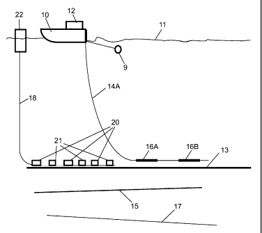
[00191 FIG. 1A shows a marine electromagnetic survey system using a horizontal
electric dipole current source.
[00201 FIG. lB shows a marine electromagnetic survey system using a vertical
electric dipole current source.
[00211 FIG. 1C shows an alternative way to energize the Earth's subsurface
using
magnetic fields.
[00221 FIG. 2 shows one example of an ocean bottom electromagnetic system
sensor.
[00231 FIG. 3A shows data as recorded on the two components of an un-oriented
receiver.
[00241 FIG. 3B shows data as rotated to the two components of the survey
coordinate system.
7
CA 02741011 2011-04-18
WO 2010/047885 PCT/US2009/055793
[00251 FIGS. 4A through 4D show typical f-CSEM data and processing thereof.
DETAILED DESCRIPTION
[00261 FIG. 1A shows one example of a marine controlled source electromagnetic
survey system for use with methods according to various aspects of the
invention. The
system includes a survey vessel 10 that moves in a predetermined pattern along
the surface
of a body of water 11 such as a lake or the ocean. The vessel 10 includes
thereon source
actuation, signal recording and navigation equipment, shown generally at 12
and referred
to herein as the "control/recording system." The control/recording system 12
includes a
controllable source of electric current (not shown separately) used to
energize electrodes
16A 16B towed in the water 11 near the bottom 13 thereof to impart an electric
field in
subsurface formations 15, 17 below the bottom 13 of the water 11. The
control/recording
system 12 typically includes instrumentation (not shown separately) to
determine the
geodetic position of the vessel 10 at any time, such as can be performed using
global
positioning system (GPS) receivers or the like. The control/recording system
12 in the
present example can include equipment to transfer signals from one or more
recording
buoys 22. The recording buoys 22 may receive and store signals from each of a
plurality
of electromagnetic (EM) sensors 20 positioned at selected positions on the
water bottom
13. Alternatively, the sensors' signals may be locally and autonomously
recorded, and
such recordings may be retrieved at the end of the survey. The sensors 20 are
commonly
deployed from the surface of the water, as autonomous nodes, without control
of the final
orientation, which must be deduced separately, as is the purpose of the
present invention.
The positions of the sensors 20 may be determined at the time of deployment
by, for
example, acoustic location techniques known in the art. The positions of the
sensors will
be used in a manner explained in more detail below.
[00271 The sensors 20 may be also disposed along a cable 18. In this case,
their
orientations are constrained by the position of the cable, which is separately
determined.
However, even in this case, the inference of the orientation of the receivers
may be
imperfect, especially in rough sea-floor conditions, and so the present
invention may also
be useful in this case. The cable 18 may be of a type ordinarily used in
connection with
seismic sensors deployed on the water bottom known in the art as "ocean bottom
cables."
The sensors 20 detect electric and/or magnetic fields that result from
electric fields
8
CA 02741011 2011-04-18
WO 2010/047885 PCT/US2009/055793
induced in the Earth's subsurface by current passing through the electrodes
16A, 16B.
The sensors 20 will be explained in more detail below with reference to FIG.
2. The
recording buoys 22 may include telemetry devices (not shown separately) to
transmit data
from the received signals to the vessel 10, and/or may store the signals
locally for later
interrogation by the control/recording system 12 or by another interrogation
device.
Alternatively, the sensors' signals may be locally and autonomously recorded,
and such
recordings may be retrieved at the end of the survey. The positions of the
sensors 20 may
be determined at the time of deployment by, for example, acoustic location
techniques
known in the art. The positions of the sensors will be used in a manner
explained in more
detail below.
[00281 The current source (not shown separately) on the vessel 10 is coupled
to the
electrodes 16A, 16B by a cable 14A. The cable 14A is configured such that the
electrodes
16A, 16B can be towed essentially horizontally near the water bottom 13 as
shown in FIG.
IA. In the present example, the electrodes can be spaced apart about 50
meters, and can
be energized such that about 1000 Amperes of current flows through the
electrodes 16A,
16B. This is an equivalent source moment to that generated in typical
electromagnetic
survey practice known in the art using a 100 meter long transmitter dipole,
and using 500
Amperes current. In either case the source moment can be about 5X10⁴ Ampere-
meters.
The electric current used to energize the transmitter electrodes 16A, 16B can
be direct
current (DC) switched off at a signal recording time-index equal to zero. It
should be
understood, however, that switching DC off is only one implementation of
electric current
change that is operable to induce transient electromagnetic effects. In other
examples, the
electric current may be switched on, may be switched from one polarity to the
other
(bipolar switching), or may be switched in a pseudo-random binary sequence
(PRBS) or
any hybrid derivative of such switching sequences. See, for example, Duncan,
P.M.,
Hwang, A., Edwards, R.N., Bailey, R.C., and Garland, G.D., 1980, The
development and
applications of a wide band electromagnetic sounding system using pseudo-noise
source.
Geophysics, 45, 1276-1296 for a description of PRBS switching. In the present
example,
as the current through the transmitter electrodes 16A, 16B is switched, a time-
indexed
recording of electric and/or magnetic fields detected by the various sensors
20 is recorded,
either in the sensor, in the recording buoys 22 and/or in the
control/recording system 12,
depending on the particular configuration of recording and/or telemetry
equipment in the
sensors 20, the recording buoys 22 and in the control/recording system 12.
9
CA 02741011 2011-04-18
WO 2010/047885 PCT/US2009/055793
[00291 The system shown in FIG. IA (as well as systems shown in and explained
with reference to FIGS. lB and 1C) is described above as using switched DC to
generate
electromagnetic fields in the subsurface. For purposes of the invention, it is
only
necessary to switch the transmitter current to generate at least one transient
electromagnetic field. The purpose of such transient electromagnetic field, as
it relates to
the present invention, will be further explained below. It is also possible to
use simple
alternating current of the type ordinarily used to conduct frequency domain
electromagnetic surveying, or any of a number of more complicated continuous
emissions
of electromagnetic energy. The purpose of such continuously emitted
electromagnetic
field, as it relates to the present invention, will be further explained
below.
[00301 FIG. lB shows an alternative implementation of signal generation and
recording, in which the transmitter electrodes 16A, 16B are arranged such that
they are
oriented substantially vertically along a cable 14B configured to cause the
electrodes 16A,
16B to be oriented substantially vertically as shown in FIG. 1B. Energizing
the electrodes
16A, 16B, detecting and recording signals is performed substantially as
explained above
with reference to FIG. IA.
[00311 Referring once again to FIG. IA, in some examples, the vessel 10 (or a
second vessel, not shown) may also be used to tow a seismic energy source,
shown
generally at 9. The seismic energy source is typically an array of air guns,
but can be any
other type of seismic energy source known in the art. The control/recording
system 12 in
such examples includes control circuits (not shown separately) for actuating
the seismic
source 9 at selected times, and recording circuits (not shown separately) for
recording
signals produced by seismic sensors. In such examples, the ocean bottom cables
18 may
also include seismic sensors 21. The seismic sensors 21 are preferably "four
component"
sensors, which as known in the art include three orthogonal geophones or
similar motion
or acceleration sensors collocated with a hydrophone or similar sensor
responsive to
pressure. Four component ocean bottom cable seismic sensors are well known in
the art.
See, for example, U. S. Patent No. 6,021,090 issued to Gaiser et al.
[00321 In some examples, a substantially contemporaneous seismic survey may be
conducted by periodically actuating the seismic energy source 9, and recording
the signals
detected by the seismic sensors 21. Interpretation of the seismic signals may
be performed
using techniques known in the art.
CA 02741011 2011-04-18
WO 2010/047885 PCT/US2009/055793
[00331 FIG. 2 shows one example of an EM sensor 20 in more detail. The EM
sensor 20 may be enclosed in a housing 23 made from a dense, electrically non-
conductive, non-magnetic material, such as high-density plastic, such that the
EM sensor
20 will sink in the water and rest on the water bottom (13 in FIG. IA).
Electrodes 26A,
26B, 28A, 28B are positioned on the bottom of the housing 23 such that they
contact the
water bottom (13 in FIG. IA). The electrodes are arranged in dipole pairs. If
the sensor is
disposed along a cable, one pair 26A, 26B can be oriented along the length of
cable (18 in
FIG. 2), and measures voltages in one direction. The other electrode pair 28A,
28B
measures voltages induced transversely to the first pair. If the sensors are
not disposed
along a cable, they still can contain two dipole pairs, substantially
orthogonal to one
another. The electrode pairs may span a distance of about 0.1 to 10 meters.
The figure is
not drawn to scale. The electrode pairs 26A, 26B and 28A, 28B may be coupled
to a
combined amplifier/digital signal processor 24 for converting the detected
voltages into
digital words corresponding to the voltage amplitude at selected moments in
time. The
present example of the sensor 20 may include one or more magnetometers 30, 32,
34
oriented along mutually orthogonal directions. In the present example, two of
the
magnetometers 30, 32 may be oriented such that their sensitive axes are
oriented along the
same direction as the dipole moment of a corresponding electrode pair 26A, 26B
and 28A,
28B. The signal output of each magnetometer 30, 32 34 may be coupled to the
digital
signal processor 24. The digitized signal output of the signal processor 24
can be coupled
to the recording buoy (22 in FIG. IA) for transmission to the
control/recording system (12
in FIG. IA) or later interrogation by the control/recording system (12 in FIG.
IA), or
stored locally for later recovery.
[00341 The example of a system shown in FIG. 1A and FIG. lB uses electric
current applied to electrodes to impart an electric field into the Earth's
subsurface. An
alternative to imparting electric fields is to impart magnetic fields, and
such will be
explained with reference to FIG. 1C. In FIG. 1C, the vessel 10 tows a cable
14C which is
connected to two loop transmitters 17A and 17B. The first loop transmitter 17A
encloses
an area perpendicular to the water bottom 13. Periodically, the
control/recording system
12 causes electric current to flow through the first loop transmitter 17A. The
current can
be in any of the same forms as described with reference to FIG. IA, including
switched
DC, PBRS, alternating polarity DC and switched AC. When the current is
switched, a
11
CA 02741011 2011-04-18
WO 2010/047885 PCT/US2009/055793
transient magnetic field having dipole moment along direction MA is imparted
into the
Earth. At the same or at different times, current is applied to the second
loop transmitter
17B. The second loop transmitter may be in the form of a solenoid or coil,
having a
magnetic moment along direction MB. Surveying using the magnetic field loop
transmitters 17A, 17B may be performed substantially according to the survey
pattern
explained above with reference to FIG. IA.
[00351 Whether sources such as shown in FIGS. 1A or lB are used, or any other
sources, electromagnetic energy is imparted into the subsurface, and may be
detected
using sensors such as shown in FIG. 2, with component amplitudes of electric
and/or
magnetic fields measured along two substantially orthogonal directions. The
measured
component amplitudes may be used, according to techniques known in the art, to
determine the direction of polarization of the electromagnetic field as it
arrives at each
individual sensor (e.g., 20 in FIG. IA). It will be appreciated by those
skilled in the art
that the receivers record a measure of the incident electromagnetic field
which is distorted
by the "system response" of the recording system; this distortion does not
affect the
determination of the orientation of the receivers as long as it is the same
for both of the
two substantially orthogonal sensing directions.
[00361 It is known from Maxwell's equations that if the medium at the location
of
the receiver is electrically isotropic, and if the electromagnetic energy
arrives at the
receiver from a single direction, then the polarization of the electromagnetic
energy is
orthogonal to that direction. Further, if the resistivity distribution in the
Earth's subsurface
is laterally invariant, the EM propagation will lie in the vertical plane
which includes both
source and receiver positions. The positions of the transmitter and the
receiver are known
or are determinable from auxiliary information. Using the foregoing
assumptions, the
known or determined positions, and the measured polarization direction may be
used to
determine the sensor orientation. The method of the present invention
recognizes that the
above assumptions are not always valid, and defines an improved method which
avoids
such assumptions.
[00371 In the following, the invention is described in an example
implementation
with electric dipole sources and electric dipole receivers; those skilled in
the art will
appreciate that the same basic principle, with ordinary modifications, can be
extended to
other types of sources and receivers, and all of these variants are included
within the scope
12
CA 02741011 2011-04-18
WO 2010/047885 PCT/US2009/055793
of this invention. It is assumed that the sensors measure orthogonal
horizontal
components of the fields, although the present invention can be extended by
those skilled
in the art in a straightforward way to cases where the receiver sensors are
non-orthogonal
and/or tilted. Following are descriptions of a t-CSEM method, then an f-CSEM
method.
[00381 In a t-CSEM method according to the present invention, when the current
is
switched to produce a transient electromagnetic field, a portion of such
electromagnetic
field will travel directly through the water, whereupon it is detected by the
sensors. Other
portions of the electromagnetic field may also travel through the air above
the air-water
interface, before being detected by the sensors. Other portions of the
electromagnetic field
may also travel through the formations below the water bottom, before being
detected by
the sensors. Such subsurface travel may deviate from that vertical plane which
includes
both source and receiver, because of a complicated distribution of electrical
resistivity in
the subsurface. As a result, such energy may arrive at the receiver from a
direction that is
not known. In such a case, the arrival polarization measured at the sensor,
although it is in
fact orthogonal to the arrival direction, cannot be used to determine the
orientation of the
sensor because the arrival direction is itself unknown. Further, the
electromagnetic energy
arriving through the subsurface may arrive from multiple directions
simultaneously
("multi-pathing"), in which case no unique arrival direction exists. Again in
such cases the
measured arrival polarization cannot be used to determine the orientation of
the receiver.
Further, the subsurface may be electrically anisotropic, so that the arrival
polarization is
not orthogonal to the arrival direction, even if the arrival direction is
known. In such a
case, again the measured arrival polarization cannot be used to determine the
orientation
of the receiver.
[00391 By selecting that portion of the measured electromagnetic field that
has
traveled only in the vertical plane which includes both source and receiver,
it is possible to
determine the orientation of the sensors without error caused by propagation
of the
electromagnetic field outside of this plane, through electrically complicated
subsurface
formations. For example, if the source-receiver offset is sufficiently small,
then the early-
time arrivals (i.e., those arriving shortly after the initiation of the t-CSEM
transient) will
arrive at the sensor directly through the water, or perhaps also through the
air, or perhaps
also refracted along the sea floor. In these cases, the above assumptions are
more
accurate, such that the energy propagation occurs substantially in the
vertical plane
13
CA 02741011 2011-04-18
WO 2010/047885 PCT/US2009/055793
including both source and sensor, since in each of these bodies (water, air,
and mud,
respectively), the spatial distribution of electrical resistivity is simple.
In this case, the
said "selected portion" of the measured electromagnetic field is the early-
time portion.
[00401 To illustrate the foregoing example, consider the data presented in
hodograms in FIGS. 3A, 3B. A hodogram is a plot of a two-component time-
series,
displayed as a curve on two component-axes. Both E-field and H-field are
displayed, both
before (FIG. 3A) and after (FIG. 3B) determination of the orientation of the
receiver. In
FIG. 3A, the axes of the plot are the axes of the receiver, as deployed, with
unknown
orientation; in FIG, 3B, the axes of the plot are inferred to be those of the
survey, ie the
ordinate (the "y-axis") is in the vertical plane which includes both source
and receiver, and
the abscissa (the "x-axis") is orthogonal to that. Note that several cycles of
t-CSEM data
are displayed (several loops of each field, with different amplitudes, each
loop
corresponding to a different source-receiver separation). The electric (E)
field loops, for
example, are asymmetrical. Each loop is a time-series, so the asymmetry means
that later-
arriving energy comes from different directions than the earlier-arriving
energy. Any
algorithm which selects a best-fit orientation will average these various
orientations (as in
the rotated FIG. 3B). This variety of directions is a consequence of the
subsurface
resistivity distribution, and has nothing to do with the true receiver
orientation. In FIG.
3B, the rotation to the inferred survey axis has used such a best-fit
orientation, this is
typical of the "simple" orientation algorithms that constitute the state-of-
the-art referred to
above.
[00411 The correct rotation angle instead should be taken from the early,
strictly
rectilinear portion of the hodogram, as indicated in FIG. 3B. This early-
arriving energy
has traveled through the water (and perhaps air and perhaps near-bottom mud)
only, thus
reasonably accurately fulfilling the assumptions of the theory. The later-
arriving energy,
arriving through the deeper subsurface, has deviated from the inline azimuth,
because of
the distribution of resistivity in the deeper subsurface. This shows in the
departure of the
hodogram from strictly rectilinear form, which is required by the theory for
simple
formations. The deviation between the correct angle, and the average angle, is
evidently
site-dependent, but even small deviations can be important, because of the
strong azimuth-
dependence of the dipole radiation pattern.
14
CA 02741011 2011-04-18
WO 2010/047885 PCT/US2009/055793
[00421 The duration of the rectilinear motion in marine surveying is a
function
mainly of the water-depth, and the source-receiver offset, and must be
determined from
the data. The EM energy normally travels faster in the deep subsurface than in
the water or
the shallow subsurface, since the electrical resistivity is normally greater
at depth. Hence,
at far source-receiver offsets, the first-arriving energy may travel by
indirect, deeper paths
than the direct arrival through the water. In such a case, this first-arriving
energy may be
arriving from unknown directions, because of complicated distributions of the
deep
subsurface resistivity, as discussed above. Thus, there may be no strictly
rectilinear
pattern displayed on the hodogram for such source-receiver offsets.
[00431 The solution to this problem is to select, from the survey dataset,
those
source-receiver offsets which in fact do display an initial rectilinear
portion of the
hodogram. (Normally, this subset will occur with the shortest source-receiver
offsets in
which the recorded signal is not so strong as to drive the recording equipment
non-
linearly.) The receiver orientation is then determined from this subset of the
data, as
above, and it is normally valid to assume that this receiver orientation
remains unchanged
for the duration of the survey, as long as that receiver is not disturbed by
the crew. Hence
this same orientation may be assumed, even for those source-receiver offsets
which did
not contribute to its determination.
[00441 For the short offsets in particular, the source-receiver azimuth may
differ
from the pre-plotted value, or from the average value. This is because the
receiver may be
positioned off the pre-plotted line (because of inaccuracies in deployment),
and because
the source vessel may drift off the pre-plotted line because of wind or
currents. (In fact,
FIG 3B shows these effects in the slightly variable azimuths of the
rectilinear portions of
the E-loops.) These effects will cause no difficulty in the orientation of the
receivers, so
long as the actual source-receiver azimuth is used in the computation, rather
than the pre-
plotted azimuth.
[00451 For added accuracy, the orientation of each receiver may be determined
separately for a number of source-receiver offsets, and the results may be
averaged,
assuming that the actual receiver orientation does not change.
[00461 It will be clear to those skilled in the art that the present invention
may be
applied separately, at each receiver, to the electric field, and, with
suitable modification
CA 02741011 2011-04-18
WO 2010/047885 PCT/US2009/055793
due to its orthogonality with respect to the electric field, to the magnetic
field. These
separate determinations of orientations may be used together (e.g. by
averaging) or
separately (e.g. through an analysis of data quality) to refine the
determination of the
receiver.
[00471 In an f-CSEM method according to the present invention, there is no
"early
time", since the source is continuously active. At all times, EM energy is
arriving at the
receivers from a series of source positions and a variety of transmission
pathways. Hence,
the t-CSEM method described above cannot be applied. One way to overcome this
is to
interrupt the f-CSEM source sequence at selected source-receiver offsets,
converting to a
t-CSEM mode of sourcing to determine each receiver orientation, and then
resuming
normal f-CSEM operations at other source-receiver offsets. This constitutes a
variant of
the t-CSEM procedure described above, but may not be operationally convenient.
[00481 Another f-CSEM method may be described using FIGS. 4A through 4D,
which are taken from the website of the Scripps Institution of
Oceanography. The two-component "Time Series" in FIG. 4A show five seconds of
recorded signals, recorded as the source vessel steams along the survey line.
Such
recorded signals are processed into the form shown in FIG. 4B as "Amplitude"
and in FIG.
4C as "Phase" at a given sensor, as a function of source-receiver offset. Also
in FIG. 4D,
the recorded signals are rotated into the survey coordinate system using the
simple
algorithm described above, although also as explained above, the hodograms do
not form
ellipses, but rather form more complicated patterns.
[00491 The shortest offsets are shown at the centers of FIGS. 4B, 4C and 4D,
with
the Amplitude graph (FIG. 4B) showing a flat region which has been clipped
because of
the non-linear effects described above occurring at the shortest offsets. This
phenomenon
also occurs in t-CSEM data, as mentioned earlier herein. For properly recorded
offsets,
just longer than the ones shown above in which clipping occurs, the EM energy
arrives
with greater amplitude than for longer offsets, according to FIGS 4B through
4D. The
strongest energy, from these selected source-receiver offsets, has arrived via
the direct
paths described above, lying in the vertical plane as described above, and the
energy
arriving by other paths, from unknown directions (caused by the unknown
subsurface
distribution of resistivity) has lower amplitude. A hodogram constructed using
just these
most energetic arrivals, with the low-amplitude arrivals of each cycle
omitted, will be
16
CA 02741011 2011-04-18
WO 2010/047885 PCT/US2009/055793
substantially rectilinear, because this selected portion of the signals will
conform most
closely to the assumptions that the energy has propagated in the vertical
plane containing
both source and receiver. As with the t-CSEM method, the details of the
process of
selecting an appropriate subset of data is to be determined by the data
themselves, guided
by the arguments above, but ultimately based upon those portions of the
hodograms which
are accurately rectilinear.
[0050] Methods according to the invention may provide more accurate
determination of electromagnetic sensor orientation than is possible using
methods known
in the art.
[0051] While the invention has been described with respect to a limited number
of
examples, those skilled in the art, having benefit of this disclosure, will
appreciate that
other examples can be devised which do not depart from the scope of the
invention as
disclosed herein. Accordingly, the scope of the invention should be limited
only by the
attached claims.
17