Note: Descriptions are shown in the official language in which they were submitted.
CA 02741844 2011-05-31
SYSTEM FOR POSITIONING A GEOSTATIONARY SATELLITE
The field of the invention is that of determining the position of a
geostationary satellite.
It is known practice to determine the position of a geostationary
satellite by using a system comprising a dedicated station for measuring
distance between this station and the satellite, such as a large transmitter
and receiver TCR (the acronym for Telemetry Command and Ranging)
station in a known position and a specific transponder on board the satellite,
included in the TCR subsystem. The orbit of the satellite is determined on the
basis of several timings of the return journey between the station and the
satellite. These measurements of the propagation time are sometimes
verified or supplemented by measurements of the azimuth and elevation of
the signal received by the station.
One of the drawbacks of this system is that the transmitter and
receiver station requires large mobile antennas which are expensive to
acquire and maintain, difficult to make robust because of the use of mobile
and motorized parts. The unfortunate consequence of this is that the orbit
control chain may become unavailable and hence the functions normally
performed such as the measurement of distance, the calculation of
manoeuvres and other operations.
Another satellite positioning system described in patent
US 6 229 477 uses a transmitter and receiver station called a primary station
and at least one other receiver and transmitter station called a secondary
station. The primary station sends a measurement signal to the satellite
which returns it to the primary station and to the secondary stations. The
secondary stations then return response-code signals to the primary station
via the satellite. The primary station determines the position of the
satellite as
a function of
- on the one hand the primary station-satellite propagation time
based on the arrival time of the measurement signal and
CA 02741844 2011-05-31
2
- on the other hand the Doppler frequency shift established on
the basis of the carrier frequency difference between the
measurement code sent and the response code received from
the secondary stations.
This system based notably on measurements of journeys, requires
the primary station to be fitted with a local clock and the departure time of
the
measurement signal to be recorded. The position obtained is then riddled
with errors due to the transmission delays of the satellite and the repeating
delays of the secondary stations.
Another satellite positioning system described in patent
US 7 512 505 uses :
- a station that is the transmitter of a signal to the satellite and the
receiver of the corresponding signal returned by the satellite, and
- several other stations for receiving the downlink signal returned by the
satellite.
This system based on measurements of arrival time requires on
the one hand that each receiver station is fitted with a local clock and that
these stations be synchronized with one another and on the other hand
requires a network for collecting the measurements taken by the receiver
stations and sent to a computer centre.
It is also possible to cite patent EP 2 148 214 which proposes a
system comprising several receiver stations for receiving a signal sent by the
satellite and a station for collecting and processing the data sent by the
receiver stations.. Each receiver station records during a determined time
window the signals transmitted by the satellite and sends to the processing
station the data representing the signals received during the said time
window. The time window associated with each station is shifted and/or of a
different size from one station to another.
As in the above case, this system based on measurements of
arrival time requires on the one hand that the receiver stations be
synchronized with one another in order to determine the time windows and
on the other hand requires a network for collecting the measurements taken
by the receiver stations and to be sent to the processing station.
3
An object of the invention is to provide a reliable system that is as
powerful and less costly than the current solutions for determining the
position
of the satellites.
The present invention uses the well known technique of TDOA "Time
Differences of Arrival", in association with a system such that all the
measurements are taken in one and the same location, either on board the
satellite or at any point in its coverage area, thus dispensing with any
system
for collecting the data in one and the same location.
It is therefore compatible with low-cost earth stations, and even with the
reuse of earth resources dedicated to each satellite, such as the existing
antennas for transmission from the earth, and "uplink" to the satellite, of
the
content to be broadcast by it.
More precisely, according to an aspect of the present invention, there is
provided a system for positioning a geostationary satellite mainly
characterized
in that it comprises:
- at least four earth stations each being in a known position and
capable
of sending to the satellite a signal called an uplink signal,
- and means for measuring the differences in the arrival times of
the uplink
signals at the satellite.
According to another aspect of the present invention, there is provided
a system for positioning a geostationary satellite, characterized in that it
comprises:
- at least four earth stations, each being in a known position
and capable
of sending to the satellite a signal called an uplink signal,
- said geostationary satellite,
- and wherein the satellite comprises means for measuring the
differences in arrival times of the uplink signals at the satellite.
CA 2741844 2018-06-28
3a
According to a first embodiment of the system according to the
invention, the earth stations are transmitter stations for transmitting the
uplink
signals generated by themselves and they comprise means for synchronizing
between them the transmission of the uplink signals.
These synchronization means of each earth station comprise for
example means for receiving a GNSS-type satellite positioning signal.
Specifically this type of signal includes a reference clock signal.
According to a second embodiment of the system according to the
invention, the earth stations are repeater stations, each uplink signal being
the repeat of a downlink signal sent by the satellite.
In this case, no synchronization of the uplink signals is necessary.
It is therefore not necessary in this embodiment for the earth stations to be
fitted with means for synchronizing with one another.
CA 2741844 2018-06-28
CA 02741844 2011-05-31
= 4
The satellite comprises for example means for generating the
downlink signal.
According to one variant, the downlink signal sent by the satellite
is transmitted by a transmitter earth station and repeated by the satellite,
the
satellite comprising means for repeating the signal received from the
transmitter earth station. This transmitter earth station may be one of the
repeater stations.
According to one feature of the invention, the means for
measuring the time differences of arrival at the satellite of the uplink
signals
are installed in a measuring earth station and the satellite comprises means
for returning the uplink signals to the measuring earth station.
According to one feature of the invention, the uplink signals are of
the same frequency and shifted in time by a known delay, the shift being
made either by the transmitter earth stations or by the repeater earth
stations.
. Other features and advantages of the invention will become
evident on reading the following detailed description made as a non-limiting
example and with reference to the appended drawings in which:
Figure a nepvesents schematically an example cf a satellite
location system according to the invention, with earth stations for
transmitting
an uplink signal,
Figure lb represents schematically the example of a satellite
location system of Figure la with the satellite synchronization means,
Figure 2a represents schematically an example of a satellite
location system accerciing to the invention with earth stations that are
repeater stations for peating a Omonlink signal generated by the satellite to
be located,
Figure 26 repnnents schetically an example of a satellite
location system according to the invention, with earth stations that are
repeater stations for repeating a downlink signal repeated by the satellite to
be located, and originating from a transmitter earth station,
Figure 3 represents schematically the example of a satellite
location system according to the invention of Figure la, the uplink signals
received by the satellite being repeatad to a processing earl" station.
CA 02741844 2011-05-31
From one figure to another, the same elements are identified by
the same reference numbers.
The invention consists in determining the position of a
5 geostationary satellite:
- by exploiting the principle of TDOA, "Time Differences Of Arrival"
,
- by using the signal-transmitting or -repeating capabilities specific to this
category of satellites, that is to say a receive antenna, a repeater (an
electronic member delivering the information of the received signal to another
to carrier signal capable of being forwarded), and a forwarding antenna
which
physically can be the receive antenna,
- and by measuring the time differences of arrival of the signals due to the
journey differences of the signals:
earth station to satellite, or
, 15 - satellite 9
earth station 9 satellite, in which case the time
differences of arrival are doubled,
the measurement being made:
- either an board the satellite,
or on the earth, after the signals have been returned by the
20 satellite to the earth.
The upiink signals involved in these measurements contain no
= information other than their own existence, or if they contain
information
because they are based on existing signals, this information is neither of any
25 use nor exploited te deteiminis the position of the satellite.
The various embodiments will now be explained in detail.
The bass.: system comprises:
- at least
four earth stations each being in a known position and
30 cata.'ib:a of
sending to the satellite a signal called an uplink
slgnai,
arid means for measuring the differences in the arrival times of
the uplink signals al the
CA 02741844 2011-05-31
6
The solution satisfies the requirement by providing a solution that
is economical and easy to make reliable:
- the low-cost earth stations may be disposed in sufficient number (at least
four, which is the mathematical minimum for the use of TDOA) so that the
system remains in operation including when one station is unavailable for a
minor or also a major unforeseen event (a seismic or climatic event for
example),
- the transmitter and receiver stations may reuse various existing structures,
typically for the vuplinking" of the telecommunications signals to be
broadcast, which structures usually already exist in several locations of the
coverage area.
According to a first embodiment described with reference to
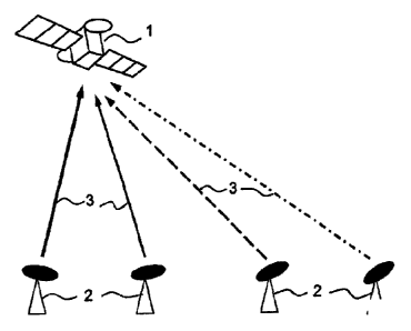
Figure I a, the earth stations are transmitter stations 2 for transmitting an
uplink signal 3 each station itself generating the signal. This signal 3 is
for
example in "burst" form, a "burst' signal being a sine wave signal with a
duration limited to a time window.
The same frequency may be used by each station since the times
of arrival are different. These earth stations are synchronized with one
another for a synchronized transmission of the uplink signals. From one
station to the other, a known delay may also be applied to the transmission of
these uplink signals.
The time difference of arrival is measured on board by means of a
specific item of hardware installed on board the satellite.
This may Le for example by using logarithmic amplifiers that are
well known in this appiicafion and described for example in the publication
"Detecting Fast RF Bursts using Log Amps" by Yuping Toh (Analog Dialogue
36-05 (2002)), followed by a comparator of electric voltages the state
transition of which triggers the startinG oi the stol.:rg of the progression
of an
oscillator, capable of providing the elapsed time between two successive
"bursts" through the knowledge of the oscillator period.
Another solution, more elegant, more preclse, more complex, but
very well known to those skilled in the art, is to use the advantages of the
spread spectrum, such as COMA, the acronym for Code Division Multiple
Access, for generating the signal, with for example the "early-late" technique
CA 02741844 2011-05-31
7
for determining its moment of arrival This TOA difference is in the form of a
number of known duration periods, available in a memory register.
This solution provides the possibility of determining orbit on board,
and of programming and executing station-holding manoeuvres
autonomously. Moreover, no data collection system is necessary: the time
differences of arrival are measured at one and the same point.
The means for synchronizing each earth station may take different
= configurations. These synchronization means are for example based on a
Global Navigation Satellite System (GNSS) such as the GPS or Galileo
system. The synchronization means then comprise a receiving device of
such a GNSS system which receives a reference clock signal. As shown in
Figure lb, it may also be a satellite synchronization system 4, as based on
the transmission of bidirectional 'signals between the stations, the departure
of which is timed by the transmitter station and the arrival is timed by the
receiver station. More precisely, each transmitter station 2 may be
synchronized by a reference clock signal in the following manner:
- A) transmitter sts.ation #1 sends via the satete 4 a signal e1 to
another
station #i (in the figure and hereinafter the example of 1=2 will be
taken) with a time of departure (or "TOD"),
B) transmitter station #2 sends a eignal 92 to station #1 with a time of
departure ("TOD"), and the Tol, of the signal sl sent in step A).
This finally gives the time shift of station #2 versus station #1:
(TOAs1--TODs1)-JOAs2-TODs2)),2
In this situation, because of the signals interchanged in the
previous protocol, oniy tation VI has all the data necessary for the
calculation.
Station i may aiso have the data, for example by regularly
repeating these interchanges and by adding to step A, by transmitting with sl
of the TOA the last signal e2 received by the station: all the stations then
operate in exacty the ailtfiG manner.
According to a second embodiment, the examples of which are
shown in Figures 2a and 2b, the earth stations are repeats:. stations 5, each
uplink signal 7 being the repeat by this station of the downlink signal 6 sent
by the satellite. This downlink signal 6 is for example in the "burst" form
CA 02741844 2011-05-31
8
already cited, and at different or identical frequencies. It may also be, for
example, a telemetry signal of the state variables of the satellite
(temperatures, electric voltages, altitude measurements, etc.) or a payload
signal (data, and/or audio, and/or video).
These earth stations may sfso transmit an uplink signal that may
differ from the downlink signal but is synchronized on receipt of this
downlink
signal (beginning, end, detection of a keyword, etc.). "Synchronized" in this
instance means that the delay between the receipt of the signal 6 and the
transmission of the signal 7 is constant as the successive transmissions
progress and has an identical duration between the stations, or known
durations for each station (if only by measurement) for taking account of the
time differences of arrival in the calculation.
No synchronization between the uplink signals 7 is necessary; it is
therefore not necessary ter the earth stations 5 to be fitted with means of
synchronization between them. The same frequency may be used by each
station since the times of arrival are different. It will be possible however,
if
necessary for the eieetronic appiication, to increase the differences of
reception of the venue; signals 7 by the satellite by applying .3 known delay
(predetermined andio:- measured more precisely as usage progresses) and
= 20 different from one station to another at the time of repetition by the
stations of
the same name. As br the previa:3 embodiment, the time difference of
arrival is measured en board by means of an item of specific hardware
installed on board the satellite. Because of the return journey, these
differences are dcubie those ef the first embodiment. This difference in TOA
is in digital form, ideielical to that teeecribed in Me first embcdirnent, or
different, analogue 'ice exartipie.
This sokrai Dikes the same advantages :
- the possibility of eetermining the orbit on board, and the programming
and execetien of the staticreitcleing reanoeuvree in an autonomous
marina%
- no data ce[iectiuil syetern is nacessary since the time differences of
anivai ere t,:i(isLireci at one dee die same pent.
loreever, d iu eolutioe lee an additional advantage: the earth
station 5 la lese easeiy end more reliable, an item of repeater equipment
being less costly than Lt.-in AaTi 'a:narrater
equipment furnished with
CA 02741844 2011-05-31
9
synchronization means, and is not subject to a possible failure of the
synchronization system.
The downlink signal sent by the satellite can be generated on
board the satellite as in the example illustrated in Figure 2a. The satellite
is
then fitted with means for transmitting a signal, for example similar to that
which exists for the sending to earth of telemetry of the states of the
satellite.
According to a variant illustrated in Figure 2b, the downlink signal
9 itself originates from a signal 8 transmitted by a transmitter earth station
10,
which signal is repeated by the satellite 1. The satellite is then fitted with
a
repeater compatible µMth the frequency or frequency band and with the level
of the signal to be repeated. The signals 8 and 9 are for example in 'burs[
form also.
According t a particular ecibodiment, one of the repeater earth
stations 6 is supplernented SC at to perform this function of a transmitter
station.
In the etarnples presented hitherto, the time difference of arrival is
measured by means of a specific item of hardware installed on board the
= satellite 1.
According to an alternative, the uplink signals are repeated by the
satellite 1 tc .21 procossing earth station 11, shown in Figure 3, which
measures the tio:.e ,:..ifference.s f arri\fal arid deduces the position of
the
satellite 1 therefrom, This repeating to a processing station 11 can be
carried
out in the situation explained with reference to Figures 1., but also for the
situations expiainc6 v4ith referer.co L iguree 2. Here again, the time
differences of an-val are ateasured at one and he same point, in this
instance the processing earth station 11. It will be noted that the time
differences of a:nvai Ln fact correspond to the time of arrival at the
satellite
TOAsat because: TOAst TOA.eai 4- ,.'.enstant,
TOAst being the !.:ina cf arrival dL: ti',e processing station 11. The
constant
disappears whe-,n the time diVerences of anival are measured.
Tiia soiution requires no specific hardware on board the satellite 1
to determine tire Oind dirierai:ceec anival. On the ether hand, the
information calcuieted on the earti can be sent b'y uplink to the satellite 1
for
example by remote dontro means that exist and are widely used for
CA 02741844 2011-05-31
controlling the satellite and keeping it operational, so that the
determination
of orbit and the programming and execution of the manoeuvres for holding
station can be carried out autonomously.
One of the repeater stations or a transmitter station may be
5 supplemented in order to perform this ; rocessing station function.
The geostationary satellite 1 to be located is for example a
telecommunications satellite or an observation or weather satellite.