Note: Descriptions are shown in the official language in which they were submitted.
CA 02742335 2011-06-06
1
METHOD AND APPARATUS FOR DETERMINING A SPATIAL POSITIONING
OF LOADING EQUIPMENT
BACKGROUND OF THE INVENTION
1. Field of Invention
This invention relates generally to equipment for loading of a payload and
more
particularly to an apparatus for determining a spatial positioning of the
loading
equipment.
2. Description of Related Art
Operation of heavy loading equipment such as electric mining shovels and
cranes
generally involves an operator controlling the equipment based on visual
feedback
of the position of an operating implement of the equipment. However, the
operator's view of the operating implement and surrounding environment may be
constrained by a limited field of view or perspective due to the operator's
location
in a cab of the loading equipment. For example, in electric mining shovels
(also
called cable shovels or rope shovels) used for excavating and loading ore
using a
dipper, the placement of the operator in the cabin is quite removed from the
actual
operation of the dipper.
Collision between loading equipment and objects or obstacles in the
surrounding
environment is a serious safety concern, and may also result in damage to the
loading equipment. It is also possible that an operator may overload and
overstress the operating components of loading equipment by subjecting the
equipment to excessive forces, due to a lack of feedback from the controls.
Monitoring systems that sense the spatial positioning of components of the
loading
equipment on the basis of relative displacement between components have two
drawbacks:
CA 02742335 2015-06-17
2
(1) They usually require re-initiation from time to time to calibrate the
system as they
may rely on signals generated by sensors such as potentiometers or resolvers,
for
example. When the loading equipment is powered down, the calibration
information
may be lost and the system will require recalibration.
(2) Mining shovels also typically operate in a harsh environment in which
there is high
likelihood of sensors on the operating components being damaged due to impact
or due
to ingress of dirt and debris. Systems that rely on signals produced from a
plurality of
sensors disposed at different locations on key components of the equipment are
particularly prone to failure.
There remains a need for improved methods and apparatus of monitoring the
spatial
positioning of operating implements of loading equipment.
SUMMARY
In accordance with one disclosed aspect, there is provided an apparatus for
determining
a spatial positioning of loading equipment, the loading equipment having an
operating
implement for loading a payload, the operating implement being coupled to a
support for
movement relative to the support. The apparatus includes an orientation sensor
disposed on the support and being operable to produce an orientation signal
representing an orientation of the support. The apparatus also includes a
displacement
sensor operable to produce a displacement signal representing a displacement
of the
operating implement relative to the support. The apparatus further includes a
processor
circuit operably configured to receive the orientation signal and the
displacement signal,
use a kinematic model of the loading equipment to compute a spatial
positioning of the
loading equipment, and produce an output signal representing the spatial
positioning.
The orientation sensor and the displacement sensor may be operable to produce
updated orientation and displacement signals during movement of the operating
CA 02742335 2011-06-06
3
implement and the processor circuit may be operably configured to receive the
updated signals and produce an output signal representing a dynamically
updated
spatial positioning of the loading equipment.
The displacement sensor may be disposed on the support.
The orientation and the displacement sensors may be each disposed within a
sensor housing mounted on the support.
The displacement sensor may be disposed on the operating implement.
The orientation signal may include information indicating at least a cardinal
heading of the support, and a pitch angle of the support.
The orientation signal may further include a roll angle of the support.
The apparatus may include an interface in communication with the processor
circuit and being operably configured to receive coordinates defining a
location of
the loading equipment with respect to an earth coordinate system, and the
processor circuit may be operably configured to use the coordinates and the
computed spatial positioning to compute a location of the operating implement
with
respect to the earth coordinate system.
The loading equipment may include a mining shovel and the processor circuit
may
be operably configured to correlate the computed location of the operating
implement with map data representing a yield expected from ore at the location
of
the operating implement to provide a yield estimate for the ore loaded in the
operating implement.
CA 02742335 2011-06-06
4
The interface may be operably configured to receive GPS coordinates defining
the
location of the loading equipment.
The orientation sensor may include a plurality of sensor elements coupled to a
microprocessor circuit, the microprocessor circuit being operably configured
to
produce the orientation signal in response to receiving signals from the
plurality of
sensor elements.
The displacement sensor may include a laser rangefinder sensor, the laser
rangefinder sensor being operable to direct a laser beam at a target located
proximate the operating implement to determine the displacement of the
operating
implement relative to the support.
The processor circuit may be operably configured to produce the output signal
by
producing a display signal operable to cause a representation of the loading
equipment to be displayed on a display for communicating the spatial
positioning
to an operator of the loading equipment.
The processor circuit may be operably configured to produce the display signal
by
producing a display signal operable to cause display of at least one of an
elevational representation of the loading equipment indicating the spatial
positioning of the loading implement with respect to the loading equipment,
and a
plan representation of the loading equipment indicating a heading of the
operating
implement.
The apparatus may include a transmitter operably configured to transmit the
output signal to a remote location to facilitate remote monitoring of loading
equipment operations.
The transmitter may include a wireless transmitter.
CA 02742335 2011-06-06
The loading equipment may include a mining shovel having a boom extending
outwardly from a frame, the support being pivotably coupled to the boom, the
operating implement including a dipper handle having first and second ends,
the
5 first end being coupled to a dipper for loading ore from a mine face, the
second
end being received in the support and being coupled to a drive operable to
cause
linear reciprocating motion of the dipper handle and dipper with respect to
the
support, and the displacement sensor is may be operably configured to receive
a
displacement signal representing a generally linear displacement between the
support and the dipper.
The apparatus may include a sensor, disposed on the frame and the processor
circuit may be operably configured to receive a signal representing a pitch
angle of
the frame and a roll angle of the frame, and use the pitch and roll angles of
the
frame to compute an orientation of the frame prior to computing the spatial
positioning of the loading equipment.
The processor circuit may be operably configured to generate a kinematic model
of the mining shovel a coupling between a crawler platform where the frame is
modeled as a first revolute joint, a coupling between the frame and the boom
is
modeled as a second revolute joint, a coupling between the boom and the
support
is modeled as a third revolute joint, and a coupling between the dipper handle
and
the support is modeled as a prismatic joint.
The dipper may be pivotably coupled to the first end of the dipper handle and
may
include an adaptor for coupling to a hoist cable, the hoist cable extending
over a
point sheave disposed at a distal end of the boom, the hoist cable being
operable
to move the dipper about the first end of the dipper handle and to move the
dipper
and dipper handle about the support during loading operations, and the
processor
circuit may be operably configured to compute an orientation and position of
the
CA 02742335 2015-06-17
6
adaptor based on a dipper tip and point sheave locations, compute a length of
the hoist
cable between the adaptor and the point sheave, compute a rotation of a sheave
wheel
based on the hoist cable displacement, and produce the output signal by
producing an
output signal representing an orientation and position of the hoist cable and
adaptor.
The spatial positioning signal may be encoded with values representing the
orientation
and displacement, and the processor circuit may be operably configured to
extract the
values, and determine compliance of the values with a set of validity criteria
prior to
using the kinematic model of the loading equipment to compute the spatial
positioning
of the operating implement.
The processor circuit may be operably configured to compute at least one of a
cyclic
activity parameter associated with operation of the loading equipment, and a
maximum
swing angle and frequency associated with a side to side swing of a rotating
platform of
the loading equipment.
The output signal representing the spatial positioning may be further provided
to an
image processing system, the image processing system being operably configured
to
capture and process images of the operating implement to determine at least
one of a
condition of the operating implement, and a condition of a payload loaded by
the
operating implement.
In accordance with another disclosed aspect, there is provided a method for
determining a spatial positioning of loading equipment, the loading equipment
having an
operating implement for loading a payload, the operating implement being
coupled to a
support for movement relative to the support. The method involves receiving
spatial
positioning signals including an orientation signal from an orientation sensor
disposed
on the, support, the orientation signal representing an orientation of the
support. The
method also involves receiving a displacement
CA 02742335 2011-06-06
7
signal from a displacement sensor, the displacement signal representing a
displacement of the operating implement relative to the support. The method
further involves, in response to receiving the spatial positioning signals,
using a
kinematic model of the loading equipment to compute a spatial positioning of
the
loading equipment, and producing an output signal representing the spatial
positioning.
The orientation sensor and the displacement sensor may be operable to produce
updated orientation and displacement signals during movement of the operating
implement and receiving the spatial positioning signals may involve receiving
the
updated signals and producing the output signal may involve producing an
output
signal representing a dynamically updated spatial positioning of the loading
equipment.
Receiving the spatial positioning signals may involve receiving a displacement
signal from a displacement sensor disposed on the support.
Receiving the orientation signal and receiving the displacement signal may
involve
receiving orientation and displacement signals from respective orientation and
displacement sensors each disposed in a sensor housing mounted on the support.
Receiving the spatial positioning signals may involve receiving a displacement
signal from a displacement sensor disposed on the operating implement.
Receiving the orientation signal may involve receiving a signal including
information indicating at least a cardinal heading of the support, and a pitch
angle
of the support.
Receiving the orientation signal may involve receiving a signal including
information indicating a roll angle of the support.
CA 02742335 2011-06-06
8
The method may involve receiving coordinates defining a location of the
loading
equipment with respect to an earth coordinate system, and using the
coordinates
and the computed spatial positioning to compute a location of the operating
implement with respect to the earth coordinate system.
The loading equipment may include a mining shovel and the method may further
involve correlating the computed location of the operating implement with map
data representing a yield expected from ore at the location of the operating
implement to provide a yield estimate for the ore loaded in the operating
implement.
Receiving the coordinates may involve receiving GPS coordinates defining the
location of the loading equipment.
Receiving the orientation signal from the orientation sensor may involve
receiving
a signal from a sensor may involve a plurality of sensor elements coupled to a
microprocessor, the microprocessor being operably configured to produce the
orientation signal in response to receiving signals from the plurality of
sensor
elements.
Receiving the displacement signal from the displacement sensor may involve
receiving a signal from a laser rangefinder sensor, the laser rangefinder
sensor
being operable to direct a laser beam at a target located proximate the
operating
implement to determine the displacement of the operating implement relative to
the support.
Producing the output signal may involve producing a display signal operable to
cause a representation of the loading equipment to be displayed on a display,
the
CA 02742335 2011-06-06
9
representation being operable to communicate the spatial positioning to an
operator of the loading equipment.
Producing the display signal may involve producing a display signal operable
to
cause display of at least one of an elevational representation of the loading
equipment indicating the spatial positioning of the loading implement with
respect
to the loading equipment, and a plan representation of the loading equipment
indicating a heading of the operating implement.
The method may involve transmitting the output signal to a remote location to
facilitate remote monitoring of loading equipment operations.
Transmitting the output signal may involve wirelessly transmitting the output
signal
to the remote location.
The loading equipment may include a mining shovel having a boom extending
outwardly from a frame, and the support may be pivotably coupled to the boom,
the operating implement including a dipper handle having first and second
ends,
the first end being coupled to a dipper for loading ore from a mine face, the
second
end being received in the support and being coupled to a drive operable to
cause
linear reciprocating motion of the dipper handle and dipper with respect to
the
support, and receiving the displacement signal may involve receiving a signal
representing a generally linear displacement between the support and the
dipper.
The method may involve receiving a signal representing a pitch angle of the
frame
and a roll angle of the frame, and using the pitch and roll angles of the
frame to
compute an orientation of the frame prior to computing the spatial positioning
of
the loading equipment.
CA 02742335 2011-06-06
Using the kinematic model of the loading equipment to compute the spatial
positioning of the operating implement may involve generating a kinematic
model
of the mining shovel where a coupling between a crawler platform and the frame
may be modeled as a first revolute joint, a coupling between the frame and the
5 boom is modeled as a second revolute joint, a coupling between the boom
and the
support is modeled as a third revolute joint, and a coupling between the
dipper
handle and the support is modeled as a prismatic joint.
The dipper may be pivotably coupled to the first end of the dipper handle and
may
10 include an adaptor for coupling to a hoist cable, the hoist cable
extending over a
point sheave disposed at a distal end of the boom, the hoist cable being
operable
to move the dipper about the first end of the dipper handle and to move the
dipper
and dipper handle about the support during loading operations, and the method
may further involve computing an orientation and position of the adaptor based
on
a dipper tip and point sheave locations, computing a length of the hoist cable
between the adaptor and the point sheave, computing a rotation of a sheave
wheel based on the hoist cable displacement, and producing the output signal
may
involve producing an output signal representing an orientation and position of
the
hoist cable and adaptor.
Receiving the spatial positioning signals may further involve receiving a
spatial
positioning signal encoded with values representing the orientation and
displacement, extracting the values, and determining compliance of the values
with a set of validity criteria prior to using the kinematic model of the
loading
equipment to compute the spatial positioning of the operating implement.
The method may involve computing at least one of a cyclic activity parameter
associated with operation of the loading equipment, and a maximum swing angle
and frequency associated with a side to side swing of a rotating platform of
the
loading equipment.
CA 02742335 2015-06-17
11
The method may involve providing the output signal representing the spatial
positioning
to an image processing system, the image processing system being operably
configured to capture and process images of the operating implement to
determine at
least one of a condition of the operating implement, and a condition of a
payload loaded
by the operating implement.
In accordance with another disclosed aspect, there is provided a sensor
apparatus for
producing spatial positioning signals for determining a spatial positioning of
loading
equipment, the loading equipment having an operating implement for loading a
payload,
the operating implement being coupled to a support for movement relative to
the
support. The sensor apparatus includes a housing operably configured to be
mounted
on the support, an orientation sensor and a displacement sensor disposed
within the
housing and being operably configured to produce spatial positioning signals
including
an orientation signal representing an orientation of the support, and a
displacement
signal representing a displacement of the operating implement relative to the
support.
The apparatus may include a processor circuit operably configured to receive
the spatial
positioning signals, to use a kinematic model of the loading equipment to
compute a
spatial positioning of the operating implement with respect to the loading
equipment,
and to produce an output signal representing the spatial positioning of the
operating
implement.
The processor circuit may be located in an enclosed location on the loading
equipment
and the support may be disposed in a location that is exposed to an
environment
surrounding the loading equipment and the housing may further include a
connector
port operably configured to receive a cable for conveying the spatial
positioning signals
between the housing and the processor circuit.
CA 02742335 2011-06-06
12
Other aspects and features of the present invention will become apparent to
those
ordinarily skilled in the art upon review of the following description of
specific
embodiments of the invention in conjunction with the accompanying figures.
BRIEF DESCRIPTION OF THE DRAWINGS
In drawings which illustrate embodiments of the invention,
Figure 1 is an elevational view of an electric mining shovel;
Figure 2 is a partially cut away perspective view of a sensor apparatus
used in
the mining shovel shown in Figure 1;
Figure 3 is a perspective view of an orientation sensor used in the
sensor
apparatus shown in Figure 2;
Figure 4 is a perspective view of a displacement sensor used in the
sensor
apparatus shown in Figure 2;
Figure 5 is a block diagram of an apparatus for determining a spatial
positioning
of the electric mining shovel shown in Figure 1;
Figure 6 is a schematic diagram a processor circuit shown in Figure 5;
Figure 7 is a flowchart depicting blocks of code for directing the
processor circuit
of Figure 6 to carry out a process for determining the spatial positioning
of the electric mining shovel shown in Figure 1;
Figure 8 is a flowchart depicting blocks of code for directing the
processor circuit
of Figure 6 to carry out a portion of the process shown in Figure 7;
CA 02742335 2011-06-06
13
Figure 9 is a simplified model of the mining shovel shown in Figure
1;
Figure 10 is a table of kinematic parameters of the mining shovel;
Figure 11 is a flowchart depicting blocks of code for directing the
processor circuit
of Figure 6 to carry out a further portion of the process shown in Figure
7;
Figure 12 is a screenshot of an exemplary mining shovel representation
produced by the processor circuit of Figure 7;
Figure 13 is an elevational view of a telescopic crane embodiment of
the
invention; and
Figure 14 is an elevational view of a tower crane embodiment of the
invention.
DETAILED DESCRIPTION
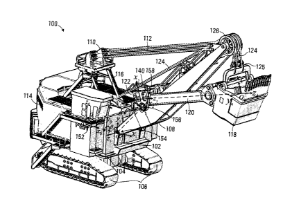
Referring to Figure 1, an electric mining shovel is shown generally at 100.
The
mining shovel 100 includes a frame 102 pivotably mounted on a crawler platform
104. The crawler platform 104 includes crawler tracks 106 for moving the
mining
shovel 100 to a loading location. The mining shovel 100 also includes a boom
108, pivotably supported on frame 102, and an A-frame structure 110 attached
to
the frame 102. The boom 108 is supported by a boom suspension cable 112.
During operation, the boom 108 is generally maintained at a fixed angle with
respect to the frame 102. The crawler platform 104 is configured to permit the
frame 102 and boom 108 to swing through an arc. Various motors and other
equipment (not shown) for operating the mining shovel 100 are supported by the
frame 102 within an equipment housing 114. The frame 102 further supports a
cabin structure 116, which houses an operator of the mining shovel and various
CA 02742335 2011-06-06
14
operating controls for use by the operator.
In this embodiment a dipper 118 is supported on a dipper handle 120. The
dipper
118 acts as an operating implement for the mining shovel. The dipper 118 and
dipper handle 120 are received in a support 122 commonly known as a saddle.
The support 122 is pivotably coupled to the boom 108 and permits the dipper
handle 120 to pivot within a vertical plane about the support. The mining
shovel
100 also includes a crowd mechanism (not shown), which is coupled to the
dipper
handle 120 for linearly extending and retracting the dipper 118 with respect
to the
support 122. The crowd mechanism may be implemented using actuators such as
hydraulic cylinders, cables, a rack and pinion drive, or other drive
mechanism.
The dipper 118 is suspended by a hoist cable 124 running over a sheave 126
disposed at the end of the boom 108. The hoist cable 124 attaches to a dipper
adaptor 125 on the dipper 118 and is actuated by a winch drive motor (not
shown)
within the equipment housing 114. The hoist cable 124 and associated drive
provides for vertical raising and lowering movement of the dipper 118 during
loading operations.
The mining shovel 100 includes a sensor apparatus 140 mounted on the support
122. The sensor apparatus 140 is operable to produce spatial positioning
signals
for determining a spatial positioning of the mining shovel 100. The sensor
apparatus 140 is shown in greater detail in Figure 2. Referring to Figure 2,
the
sensor apparatus 140 includes a housing 142 and a mount 144 for mounting the
housing on the support 122. The sensor apparatus 140 also includes an
orientation sensor 160 and a displacement sensor 162 disposed within the
housing 142. The sensors 160 and 162 are operably configured to produce
spatial
positioning signals including an orientation signal representing an
orientation of the
support 122, and a displacement signal representing a displacement of the
dipper
118 relative to the support. The sensor apparatus 140 also includes a
connector
port 146 on the rear of the housing 142 for connecting signal lines for
receiving the
CA 02742335 2011-06-06
spatial positioning signals from the sensors 160 and 162 and for connecting
operating power to the sensors. In other embodiments, the sensor apparatus 140
may include a wireless interface for transmitting the spatial positioning
signals.
5 In the embodiment shown in Figure 2, the orientation sensor 160 is a MEMS
(microprocessor-electro-mechanical systems) orientation sensor such as the
Xsens MTi manufactured by Xsens, An Enschede, The Netherlands. Other
examples of suitable orientation sensors (also called 3DOT sensors) that may
be
used in this application are the 3DM-GX2 from MicroStrain Inc of Williston,
VT,
10 USA, the InertiaCube 2+ from InterSense Incorporated of Billerica MA,
USA, and
the Liberty electromagnetic tracker from Polhemous of Colchester, VT, USA.
Referring to Figure 3, the Xsens MTi sensor 160 includes a housing 202 and a
mounting base 204 that defines a right handed Cartesian co-ordinate system 206
15 for the sensor. The housing 202 of the sensor 160 encloses a temperature
sensor, three accelerometers respectively aligned to the X, Y, and Z axes 206
for
measuring linear accelerations (sensitive to the earth's gravitational field),
three
magnetometers for measuring the earth's magnetic fields to determine a
cardinal
direction with respect to the earth's magnetic field, and three rate
gyroscopes for
measuring a rate of rotation about the X, Y, and Z axes.
The sensor 160 further includes signal conditioning amplifiers to condition
signals
produced by the various included sensors, analog to digital converters, and a
dedicated digital signal processor (DSP), disposed within the housing 202. The
DSP receives the various signals generated by the gyroscopes, magnetometers
and accelerometers and uses a proprietary algorithm to process the signals,
apply
various corrections and calibration factors, and generate a 3D heading and
attitude of the sensor 160. The static accuracy of the generated heading is
considered to be less than 10 and the static accuracy of the attitude less
than 0.5 .
The DSP encodes the generated 3D attitude and heading into a data stream and
CA 02742335 2011-06-06
16
produces a data signal output at a port 208. The produced data signal may be
compliant with a data signalling protocol such as RS-323, RS-485, RS-422, or
USB. Configuration commands may also be transmitted to the DSP via the port
208, using the data signalling protocol. Power for operating the DSP and the
various sensor elements is also connected to the sensor 160 though the port
208.
In the sensor apparatus 140 shown in Figure 2, power and signal lines of the
port
208 of the orientation sensor 160 are connected to the connector port 146 of
the
sensor apparatus 140.Advantageously, the orientation sensor 160 provides an
accurate 3D heading and attitude of the housing 142 of the sensor apparatus
140
in any of a variety of signal formats. The orientation sensor 160 is also
fully
enclosed within the housing 202, which provides protection for sensor elements
when operating in a harsh environment such as a mine. In other embodiments,
the MEMS based orientation sensor may be substituted by other sensors that
provide heading and attitude. For example, a biaxial accelerometer may be used
to produce orientation signals representing the attitude of the support 122,
and the
signals may be filtered using a low pass filter to remove high frequency
variations
in the signal. A compass type sensor may be used to provide a heading signal.
In the embodiment shown in Figure 2, the displacement sensor 162 comprises a
laser rangefinder such as the Acuity AR4000 system manufactured by Schmitt
Industries of Portland, Oregon, USA. Other examples of suitable rangefinder
sensors that may be used in this application are the DT500 from Sick AG,
Waldkirch, Germany, the LDM 42 from Jenoptik AG of Jena, Germany, the LLD
sensor from Waycon Positionsmesstechnik, Taufkirchen, Germany, and the DLS-
BH from Dimetix, of Herisau, Switzerland. The aforementioned rangefinder
sensors are examples of non-contact laser rangefinders. It is however also
possible to use other absolute linear displacement sensors such as a
magnetostriction linear-position sensor for example.
An example of a
magnetostriction sensor is the Temposonic linear position sensor, produced by
CA 02742335 2011-06-06
17
MIS Systems Corporation of Cary, NC, USA, which provides a dynamic reading of
absolute displacement at an accuracy of 0.01".
Referring to Figure 4, the laser rangefinder displacement sensor 162 includes
a
sensor housing 232 having a data port 236 and data cable 238 for carrying data
signals to and from the displacement sensor 162. The displacement sensor 162
receives electrical operating power via a power cable 234. The housing 232
also
includes a window 240. A laser diode (not shown) is disposed to direct a
collimated beam of light through the window 240 toward a target. In this
embodiment the target is located on the dipper 118 and a surface finish of the
dipper may provide for sufficient reflection to act as the target.
In other
embodiments a reflective element may be disposed on the dipper to provide an
enhanced reflection, or alternatively the displacement sensor 162 may be
disposed on the dipper handle 120 and configured to measure a distance between
the sensor and the support 122. The laser diode may have a visible or infrared
wavelength. Light reflected back from the target is collected by a Fresnel
collection lens and directed to an avalanche detector located within the
housing
232.
The displacement sensor 162 also includes a processor circuit (not shown) that
implements a modified time-of-flight measurement principle for processing the
return signal from the avalanche detector to generate a displacement signal.
The
displacement signal provides an absolute measurement of the displacement
between the housing 232 and the target. The processor circuit encodes the
displacement into a data stream and produces a data signal output at the data
port
236, which may be compliant with a data signalling protocol such as RS-323, RS-
485, or RS-422.
Referring back to Figure 2, the housing 142 also includes a turret 148. The
housing 142 further includes a window 150 that allows the light beam to be
CA 02742335 2011-06-06
18
transmitted, while protecting the sensors 160 and 162 and interior of the
housing
from egress of water and contaminants. In one embodiment the window 150
comprises a lexan-sapphire window material. The turret 148 extends outwardly
to
protect the window from falling debris or dirt.
Advantageously, the orientation signal and displacement signal provide
continuous
real-time information during normal operation of the mining shovel 100, and it
is
not necessary to stop operating the dipper 118 to sense the disposition of the
dipper or other operating implement. Furthermore there is no need to move the
dipper 118 or dipper handle 120 to a reference spatial position to calibrate
the
sensors, since the orientation signal is referenced to the earth's magnetic
and
gravitational field.
Referring to Figure 5, a block diagram of an apparatus for determining a
spatial
positioning of loading equipment, such as the electric mining shovel, is shown
generally at 250. The apparatus 250 includes the sensor apparatus 140 shown in
Figure 2, and further includes a processor circuit 300. The processor circuit
300 is
coupled by a cable 166 to the connector port 146 of the sensor apparatus 140
for
receiving the orientation signal and the displacement signal. The processor
circuit
300 is further configured to use a kinematic model of the loading equipment to
compute an orientation and a position of the dipper 118 and dipper handle 120
of
the electric mining shovel. The apparatus 250 further includes a display 252
in
communication with the processor circuit 300, which is operably configured to
produce an output signal representing the orientation and the position of the
dipper
118 and dipper handle 120.
In a mining shovel embodiment, the processor circuit 300 would most likely be
located in the cabin 116, and the cable 166 would be routed along the boom 108
to between the sensor apparatus 140 and the cabin. Advantageously, in the
embodiment shown in Figure 1, while the sensor apparatus 140 would necessarily
CA 02742335 2011-06-06
19
be exposed to an environment surrounding the mining shovel 100, the processor
circuit 300 is located within the cabin 116 (or in the equipment housing 114)
thereby reducing the likelihood of damage.
The sensor apparatus 140 is mounted on the saddle block or support 122 with
the
X-axis 206 of the orientation sensor 160 aligned along the boom 108, such that
the
orientation signal received from the sensor apparatus 140 provides a heading
of
the boom with respect to the ground. The orientation signal received from the
sensor apparatus 140 also provides the attitude (i.e. the pitch, roll, and yaw
angles
of the support 122 thereby providing the attitude of the dipper handle 120,
which is
coupled to the support.
The light beam produced by the displacement sensor 162 is reflected back to
the
sensor apparatus 140 from the dipper 118, and the displacement signal produced
by the sensor apparatus thus provides the location of the dipper with respect
to the
sensor apparatus 140. In the electric shovel embodiment shown in Figure 1, the
boom 108 is generally maintained at a substantially fixed angle and the
attitude
and heading of the saddle support 122 and the extension of the dipper 118,
along
with geometric configuration details of the mining shovel components, provides
sufficient information to facilitate computation of the spatial positioning of
the
dipper handle 120, boom 108, cabin 116, and frame 102, as detailed later
herein.
Alternatively, in other embodiments where the support is mounted on a boom
that
is not disposed at a fixed angle, or where it is desired to account for small
angular
movements due to compliance of the boom suspension cable 112, an additional
orientation sensor may be disposed on the boom to determine the actual boom
angle with respect to the cabin. The additional orientation sensor may be a
single
axis orientation sensor or a 3D orientation sensor such as the sensor 160.
The processor circuit 300 is shown in greater detail in Figure 6. Referring to
Figure 6, the processor circuit 300 includes a microprocessor 302, a program
CA 02742335 2011-06-06
memory 304, a variable memory 306, a media reader 308, and an input output
port (I/O) 310, all of which are in communication with the microprocessor 302.
Program codes for directing the microprocessor 302 to carry out various
functions
5 are stored in the program memory 304, which may be implemented as a
compact
flash memory or other memory such as a random access memory, hard disk drive,
or a combination thereof. The program memory 304 includes a first block of
program codes 320 for directing the microprocessor 302 to perform operating
system functions. In one embodiment the program codes 320 may implement the
10 Windows Embedded operating system, produced by Microsoft Corporation of
Redmond, Washington, USA. The program memory 304 also includes a second
block of program codes 322 for directing the microprocessor 302 to perform
functions associated with determining the spatial positioning of the mining
shovel
100.
The media reader 308 facilitates loading program codes into the program memory
304 from a computer readable medium 312, such as a CD ROM disk 314, or a
computer readable signal 316, such as may be received over a network, for
example.
The I/O 310 includes a first input 330 for receiving an orientation signal
from the
orientation sensor 160 and a second input 332 for receiving the displacement
signal from the displacement sensor 162. The I/O 310 also includes a third
input
334 for receiving a cab orientation signal and a fourth input 336 for
receiving a
GPS location signal. The cab orientation signal and GPS location signals are
described later herein. The I/O 310 further includes a first output 340 for
producing a display signal for controlling the display 252 and a second output
342
for producing a signal for controlling a wireless transmitter 350.
CA 02742335 2011-06-06
21
The variable memory 306 includes a plurality of storage locations including a
memory store 360 for storing an attitude value, a memory store 362 for storing
a
heading value, a memory store 364 for storing a displacement value, a memory
store 366 for storing current data set values, a memory store 368 for storing
kinematic model parameter values, a memory store 370 for storing computed
spatial positioning data values, a memory store 372 for storing graphic images
of
shovel components, and a memory store 374 for storing a historic data log. The
variable memory 306 may be implemented in random access memory, for
example.
Referring to Figure 7, a flowchart depicting blocks of code for directing the
processor circuit 300 to determine the spatial positioning of the mining
shovel 100
is shown generally at 400. The blocks generally represent codes that may be
read
from the computer readable medium 312, and stored as program codes 322 in the
program memory 304, for directing the microprocessor 302 to perform various
functions related to determining spatial positioning. The actual code to
implement
each block may be written in any suitable program language, such as C, C++
and/or assembly code, for example.
The process begins at block 402, which directs the microprocessor 302 to
receive
the spatial positioning signals from the sensor, including the orientation
signal and
the displacement signal. In one embodiment the spatial positioning signals are
received from the orientation sensor 160 and displacement sensor 162 at a
regular
update interval and, block 402 directs the microprocessor 302 to decode the
orientation signal to generate attitude and heading values and to store the
values
in the respective memory stores 360 and 362 of the variable memory 306 (shown
in Figure 6). In this embodiment, the orientation sensor 160 uses the
magnetometers to determine a magnetic north direction with respect to the
earth's
magnetic field. The internal DSP in the orientation sensor 160 also determines
the
pitch, roll, and yaw of the mounting base 204 of the sensor 160. The Yaw
angle,
CA 02742335 2011-06-06
22
expressed relative to magnetic north, provides a compass heading of the sensor
and thus the saddle support 122 and dipper handle 120. This yaw angle is saved
as the heading (i.e. at) in the heading memory store 362. The pitch angle
generated by orientation sensor 160 provides the attitude of the mounting base
204 of the sensor 160, and thus the attitude of the support 122 and dipper arm
120. The pitch angle is saved in the attitude memory store 360.
Block 402 also directs the microprocessor 302 to decode the displacement
signal
to generate a displacement value d and to store the displacement value in the
memory store 364 of the variable memory 306.
Block 404 then directs the microprocessor 302 to process and validate the
values
stored in the memory stores 360 ¨ 364. For example, the values may be
compared to criteria such as maximum and minimum values expected based on
the geometry of the mining shovel 100 and values that do not meet the
criteria, or
values that result from a false sensor reading, for example, will be
discarded.
The process 400 then continues at block 406, which directs the microprocessor
302 to retrieve current values of attitude, heading, and displacement from the
memory stores 360 ¨ 364 and to store the values as a data set in the memory
store 366 of the variable memory 306. The memory stores 360 ¨ 364 thus act as
containers for receiving values streamed from the sensors 160 and 162, while
the
memory store 366 is used to store a validated set of values representing the
orientation of the support 122 and the displacement of the dipper 118 at a
particular time.
Block 408 then directs the microprocessor 302 to read parameters associated
with
a kinematic model of the mining shovel 100 from the memory store 368 of the
variable memory 306 and to compute the spatial positioning of the loading
equipment using the kinematic model. The process 400 then continues at block
CA 02742335 2011-06-06
23
410, which directs the microprocessor 302 to produce an output signal
representing the computed spatial positioning.
The process of block 408 shown in Figure 7 for computing the spatial
positioning
of the electric mining shovel 100 is shown in greater detail at 408 in Figure
8.
Referring to Figure 8, the process 408 begins at block 440, which directs the
microprocessor 302 to read the kinematic model parameters from the memory
store 368 of the variable memory 306 (shown in Figure 6).
In one embodiment, the mining shovel 100 may be modeled using the Denavit-
Hartenberg method, which provides a convention for selecting frames of
reference
in robotics applications. Referring back to Figure 1, the mining shovel 100
may be
treated as a 4 degree of freedom (DOF) manipulator having three revolute
joints
and one prismatic joint. The three revolute joints include a joint 152 between
the
crawler platform 104 and the cabin that permits the cabin to swing about the
crawler platform (angle 0/), a joint 154 between the frame 102 and the boom
108
(i.e. angle (92), and a joint 156 between the saddle support 122 and the boom
(i.e.
angle 6)3) that allows the saddle to pivot to accommodate raising or lowering
of the
dipper 118. In this embodiment the boom joint angle e2 is taken into account
as a
fixed angle. In other embodiments, the boom joint angle may be taken into
consideration as a variable angle, since in operation the boom 108 may undergo
small angular displacement about the boom joint 154 due to the compliance of
the
suspension cable, particularly when the dipper 118 is fully loaded.
Furthermore, in
some circumstances the boom 108 may pivot upwardly when the dipper 118
engages the mine face and the dipper and dipper handle 120 continue to move
away from the boom. When the dipper 118 is subsequently retracted by the
operator, the boom may come down with an impact against the boom suspension
cable 112. This condition is referred to as boom jacking, and may be accounted
for by inclusion of a further boom angle sensor as described earlier herein.
CA 02742335 2011-06-06
24
The prismatic joint comprises a joint 158 between the dipper handle 120 and
the
saddle support 122 and takes into account an extension d of the dipper handle
with respect to the support 122 due to operation of the crowd mechanism.
The mining shovel 100 shown in Figure 1 may be represented by a simplified
model shown in Figure 9 at 500 where the ground is represented by a plane 502
and where the joints 152 ¨ 158 are respectively defined by respective xyz
Cartesian coordinate frames 00, oi, 02 and 03. The operating implement (in
this
case the dipper 118) is represented by a frameo4 in Figure 9. The Denavit-
Hartenberg parameters of the mining shovel 100 are shown in tabular form in
Figure 10 at 520, where el - e3 and d4 are the joint angular and linear
displacements as discussed above, al is the link length between oo and 01, a2
is
the link length between 01 and 02, and a3 is the link length between 02 and
03. The
angles al - a4 are angular offsets of the respective z-axes (zo ¨ z4) in
moving
between the respective coordinate frames at the joints oo¨ 03 and frame 04.
The boom 108 is included as a link in the simplified model 500, and its
connection
to the frame 102 is defined as a passive joint o1, since in this embodiment
the
boom joint is considered fixed.
The parameters in the table of Figure 10 are stored in the memory store 368 of
the
variable memory 306. As noted above, block 440 directs the microprocessor 302
to read the parameters from the memory store 368.
The process then continues at block 442, which directs the microprocessor 302
to
compute the orientation of the cabin 116 (i.e. al) and the resulting position
of the
boom joint 154. Since the boom 108 is aligned with the cabin 116, block 442
directs the microprocessor 302 to read the yaw angle value stored in the
memory
store 366 of the variable memory 306, which is used as the angle el. The boom
joint (of) position with respect to the joint 152 (oo) is then determined from
the
CA 02742335 2011-06-06
angle e, and the link length a2. In this embodiment it is assumed that the
cabin
116 and frame 102 are horizontally oriented with respect to the ground, but in
other embodiments the cabin pitch and roll orientations may be provided by a 3-
axis accelerometer, such as the CXL-GP accelerometer produced by Crossbow
5 Technology, Inc. of San Jose, California, USA, or by a roll/pitch sensor
provided
by the same company, or an Xsens MTi sensor, as described above. When
provided, such a sensor provides an orientation of the frame 102, which, since
the
boom 118 is attached to the frame, will have some influence on the spatial
positioning of the shovel when the cabin is not horizontally oriented.
Block 444 then directs the microprocessor 302 to read the boom joint angle 02,
which in the embodiments above is considered to be fixed, but may be sensed by
a high resolution joint angle sensor, as described above. Block 444 further
directs
the microprocessor 302 to compute the position of the joint 156 (02) using the
angle 02 and the link length a2.
Block 446 then directs the microprocessor to compute the position and
orientation
of the joint 158 (03) of the saddle support 122.
Block 446 directs the
microprocessor 302 to read the pitch angle of the saddle support 122 from the
memory store 366 of the variable memory 306, which provides the angle e3.
Block
446 further directs the microprocessor 302 to compute the position of the
joint 03
from the angle 03 and the link length a3. The orientation of the prismatic
joint 03
provides the orientation of the dipper handle 120, which in this embodiment is
assumed to be rigidly coupled for substantially linear extension and
retraction with
respect to the support.
The process then continues at block 448, which directs the microprocessor 302
to
read the measured displacement d4 from the memory store 366 of the variable
memory 306 and to compute the resulting position of the dipper 118 (i.e. the
frame
as) using the angle 03 and the displacement da.
CA 02742335 2011-06-06
26
In another embodiment, the Denavit-Hartenberg model parameters may be used
to generate a transform matrix, which may be used to simultaneously execute
the
blocks 442 ¨ 448 shown in Figure 8.
Considering the mining shovel 100 represented in Figure 1 as a series of
links,
with a frame rigidly attached to each link, the location and orientation of
the bucket
or the end-effecter (frame 04) may be expressed with respect to the base frame
oo
as:
To4 = Aoi (692412 (92 )1423 (03 )A34 (d4 ) Eqn 1
The transformation matrix T04 is a transformation matrix from the dipper 118
to the
crawler platform 104, where:
c, 0 s, a,c, c2 ¨S2 0 a2 C2
S1 0 ¨ c, ais, s2 C2 0 a2 S2
4, = Al2 =
0 1 0 0 0 0 1 0
0 0 0 1_ 0 0 0 1
_
_
1 0 0 0
0 1 0 0
A34 =
- -
C3 0 S3 a 3 C3 0 0 1 d,
A = s, 0 -c3 a3S3 0 0 0 1 - -
23 0 1 0 0
0 0 0 1 _
and where:
o0,x0,Y0,z0 coordinate frame of the swing revolute joint
oi,xi,Yi,z/ coordinate frame of the boom revolute joint
o2,x2,Y2,z2 coordinate frame of the saddle block revolute joint
o3,x31y3,z3 coordinate frame of the crowd prismatic joint
CA 02742335 2011-06-06
27
a4,x41y414 coordinate frame of the operating implement
perpendicular distance from zo to z1 (the length of link 1)
a2 perpendicular distance from z1 to z2 (the length of
link 2)
a3 perpendicular distance from z2 to z3 (the length of
link 3)
s1 sin 9(i=1, 2, 3)
cos ei (1=1, 2, 3)
S23 sin (92+93)
C23 cos (e2+193)
el angular displacement of the swing joint
e2 angular displacement of the boom joint
e3 angular displacement of the saddle block joint
cla linear displacement of the crowd joint which
corresponds to
the linear movement of the dipper handle relative to the
saddle block or the distance from the saddle block to the
center of the dipper
A1-1,1 coordinate transformation matrix from frame oi to
frame oi.4
coordinate transformation from the operating implement (i.e.
dipper 118) frame to the base frame.
cc s c s cs d +cc a +cca +c
1 23 1 I 23 1 23 4 1 23 3 I 2 2 1a
1
SC -C SS ss d +sc a +sca +s
1 23 1 1 23 1 23 4 I 23 3 1 2 2 1a1
To4 = Eqn 2
s23 0 -C23 -C23d4 + S23a3 + a252
0 0 0 1
In other embodiments the process 440 shown in Figure 8 may include further
steps for computing the orientation and position of the hoist cable 124. Block
450
directs the microprocessor 302 to compute the position of the sheave 126,
which
is provided by the boom angle 82 and a known spacing between the joint oi and
the sheave. The computed position of the dipper 118 also facilitates
determination
CA 02742335 2011-06-06
28
of the dipper adaptor 125, thus allowing computation of the orientation of the
hoist
cable 124.
The process 440 then continues at block 450, which directs the microprocessor
301 to store the computed data defining the spatial positioning of the
components
of the mining shovel 100 in the memory store 370 of the variable memory 306.
The process of block 410 shown in Figure 7 for producing display signals for
displaying a representation of the electric mining shovel 100 is shown in
greater
detail in Figure 11. An exemplary representation of the mining shovel 100
produced by the processor circuit 300 on the display 252 is shown at 550 in
Figure
12. Referring to Figure 11, the process 410 begins at block 480, which directs
the
microprocessor 302 to read the computed data defining the spatial positioning
of
the components of the mining shovel 100 from the memory store 370. Block 482
then directs the microprocessor 302 to read graphic images of a first shovel
component from the variable memory 306. Each major component of the mining
shovel such as crawler platform 104, frame 102 and cabin 116, boom 108, saddle
support 122, dipper handle 120 and dipper 118 may have an associated graphic
image that may be used to generate a representation of the mining shovel 100
in
the correct spatial positioning.
Block 484 then directs the microprocessor 302 to position the first graphic
image in
space. In this embodiment the crawler platform 104 is used as a reference and
thus does not require any change of spatial positioning and is displayed as
shown
in Figure 12. Referring to Figure 12, the representation 550 includes an
elevational view 552 of the mining shovel 100 and a plan view 554 of the
shovel.
In the embodiment shown, the orientation of the crawler tracks is not computed
and a crawler platform representation 556 is shown in a default horizontal
orientation.
CA 02742335 2011-06-06
29
Referring back to Figure 11, the process then continues at block 486, which
directs the microprocessor 302 to determine whether further graphic images
remain to be displayed, in which case the process continues at block 488.
Block
488 directs the microprocessor 302 to read the next graphic image from the
memory 372. Block 488 then directs the microprocessor 302 to repeat blocks 484
and 486 for the next graphic image, which in this embodiment would be the
frame
and the cabin of the mining shovel 100. Referring to Figure 12, the cabin and
frame are shown at 558, and the image representation is rotated in the plan
view
554 to show the heading of the cabin relative to the crawler platform, which
is not
clearly visible in the plan view representation 554.
Blocks 484 and 486 are then repeated for the remaining graphic images of the
boom 560, saddle support 562, dipper handle 564, dipper 566, and hoist cable
568, as shown in Figure 12. If at block 486, it is determined that the last
graphic
images has been processed, block 486 directs the microprocessor 302 to block
490. Block 490 directs the microprocessor 302 to cause the I/O 310 (shown in
Figure 6) to output a display signal at the first output 340 for displaying
the
resultant mining shovel representation image 550 on the display 252.
Advantageously, the representation in Figure 12 provides an operator of the
mining shovel 100 with a real time display of the spatial positioning of the
various
components of the shovel that forms useful feedback for operations.
The representation 550 also provides a data logging control panel 570 that
facilitates input by the operator to start logging shovel data. When a start
button
572 is activated by the operator (for example by touching a touch sensitive
area of
the display 252), the spatial positioning data in the memory store 370 is
copied to
the data log memory store 374 in the variable memory 306. The memory store
370 thus accumulates subsequent updated spatial positioning data associated
with operation of the mining shovel 100, thus providing a historic record of
shovel
operations over time. The historic record may be used to analyze performance
of
CA 02742335 2011-06-06
the mining shovel and/or operator. For example, loading operations that result
in
excessive cabin swing about the crawler platform to a particular side may
result in
preferential wear to components and may be discerned by examining swing angle
data in the historic record. Analysis may also be performed to determine other
5 performance indicators such as non-digging time, or a cyclic activity
parameter
associated with operation of the loading equipment, for example.
Advantageously,
the historic record may provide a useful indication of mining shovel
performance
and performance of specific operators assigned to operate the shovel.
10 In a further embodiment, the microprocessor 302 may be further
configured to
cause the I/O 310 to output a data signal encoding the data set values stored
in
the memory store 366 or the historic data 374 at the second output 342 for
transmission to a remote location by the wireless transmitter 350. In one
embodiment, the remote location may be a dispatch center associated with mine
15 operations, and the transmission may be used to provide data for
monitoring
operations of the mining shovel 100.
In the embodiments described above, while spatial positioning is determined
with
respect to magnetic north, the exact location of the mining shovel 100 is not
20 available. Referring back to Figure 6, in an alternative embodiment, the
mining
shovel 100 may be equipped with GPS receiver, and a GPS location signal may
be received at the fourth input 336 of the I/O 310. The GPS location signal
provides a real time absolute location of the mining shovel frame oo (shown in
Figure 9), and may be used by the microprocessor 302 to compute respective
25 absolute locations of the shovel components, such as the dipper 118. For
loading
equipment that does not have a GPS receiver, the orientation sensor 160 may be
replaced by a sensor that has an integrated GPS receiver and provides GPS
location in addition to the attitude and heading. Advantageously, accurately
sensing an absolute location of an operating implement (such as the dipper
118)
30 by combining GPS sensor signals and spatial positioning information
provided by
CA 02742335 2011-06-06
31
the apparatus 250 is particularly useful in mining of minerals such as
precious
metals (for example gold and platinum). Knowledge of a precise digging
location
may be correlated with the geological map of the mine to determine a
percentage
yield of ore being loaded by the dipper 118, thus facilitating efficient
mining of ore
from the mine.
Advantageously, the apparatus 250 disclosed above determines a real-time
spatial
positioning of the dipper 118 with respect to the crawler platform 104 of the
mining
shovel 100. The determined spatial position of the dipper 118 may be used by
other systems for monitoring operations of the mining shovel 100. For example,
Motion Metrics International Corp of Vancouver, BC, Canada provides the
ToothMetricsTm and WearMetricsTm systems for monitoring a condition of the
dipper teeth that engage the mine face during digging operations and are prone
to
wear and damage, as well as the FragMetricsTm system that provides information
of the condition of the payload. These systems operate on the basis of views
of
the dipper captured by camera. Accordingly, prior knowledge of the spatial
positioning or posture of the dipper handle 120 and dipper 118 reduces image
processing required to locate the dipper and determine the spatial positioning
of
the dipper in the image. The spatial positioning information provided by the
apparatus 250 may be used to confirm the orientation of the dipper handle 120
and dipper 118 and/or to reduce the processing necessary to locate these
components in the captured images.
While the embodiments have been described in connection with the mining shovel
100 shown in Figure 1, the sensor apparatus 140 and processor circuit 300 may
be implemented on other loading equipment such as various types of cranes,
mining shovels, and other heavy machinery where collective movement of
specific
components is necessary for the safe and efficient operation of the machinery.
Accordingly, various aspects of the invention may be implemented in equipment
used in quarries, construction, and oil industries, for example.
CA 02742335 2011-06-06
32
An example of a telescopic crane is shown in Figure 13 at 580. The crane 580
includes a telescopic boom 582 that is configured to pivot about a support
584. A
sensor apparatus, such as the sensor apparatus 140 shown in Figure 2 may be
mounted on the boom 582 of the crane 580 to provide both an orientation of the
boom and a distance d to the end of the boom, which corresponds to the
extended
length of the boom. A display in an operating cabin of the crane 580 may be
configured to display a representation of the crane in a similar manner to
that
described above in connection with the representation shown in Figure 12 at
550.
An example of a tower crane is shown in Figure 14 at 590. The crane 590
includes a boom or horizontal jib 592 and a trolley 594 configured to travel
along
the jib. The trolley includes a sheave for guiding a lifting cable 596 that
supports a
hook block 598. A sensor apparatus may be mounted on the jib 592 to provide
both an orientation of the jib and a distance d to the trolley 594. As in the
telescopic crane example above, a display in an operating cabin of the crane
590
may be configured to display a representation of the crane 590.
Advantageously, the above embodiments provide absolute orientation information
associated with working components of the loading apparatus on which the
sensor
apparatus is installed. Furthermore, orientation information is provided by
sensors
housed in a common housing, such as the housing 142 shown in Figure 2, thus
simplifying mounting and installation of the sensor apparatus.
While specific embodiments of the invention have been described and
illustrated,
such embodiments should be considered illustrative of the invention only and
not
as limiting the invention as construed in accordance with the accompanying
claims.