Note: Descriptions are shown in the official language in which they were submitted.
CA 02743240 2011-05-10
WO 2010/053840 PCT/US2009/062794
- 1 -
AZIMUTHALLY SENSITIVE RESISTIVITY LOGGING TOOL
Paul L. Sinclair
Joseph K. Clontz
TECHNICAL FIELD
This invention relates to the field of logging while drilling, particularly as
used in oil and gas
development and exploration.
BACKGROUND ART
Logging is a technique that is used to measure one or more characteristics,
such as resistivity, of
subsurface geologic formations. Such a measurement can be used, for example,
to determine the type of
subsurface formation surrounding a drill bit. Accordingly, logging provides
useful information to
engineers and geologists engaged in hydrocarbon exploration and production as
well as similar fields,
such as mining.
Logging can be performed by inducing a current to flow in a formation and then
selectively
measuring the current distribution. Several different techniques for
performing logging have been
developed. For example, open-hole logging involves in removing the drill pipe
and bit from a wellbore
and then lowering an open-hole logging tool into the wellbore to obtain the
desired measurements.
Logging-while-drilling (LWD, also known as measurement-while-drilling (MWD))
systems have
also been developed. These systems differ from open-hole logging in that
measurements can be obtained
while the drill pipe is in the wellbore. LWD systems permit log information,
such as resistivity, to be
measured in a formation very soon after the formation is penetrated by the
drill bit. This provides
substantially "real-time" information that (a) is obtained before the
formation is substantially altered by
inflow of drilling fluids or other factors and (b) may be used by the driller
to control the drilling
operation, for example by steering the bit so as to penetrate (or so as not to
penetrate) a selected
formation detected by the LWD system. LWD systems typically include
transmitters and sensors
disposed in or on sections of drill pipe that are located near the drill bit.
Some existing LWD systems have developed techniques to determine whether the
drill bit is
approaching an anomaly within a formation. However, these techniques generally
lack the ability to
pinpoint the location of the anomaly relative to the drill bit. Such
techniques also lack the ability to
distinguish between a more conductive anomaly on one side of the drill bit and
a less conductive anomaly
on the other side of the drill bit. In addition, existing techniques typically
employ sensors that are
responsive in only one rotational direction, requiring rotation of the entire
drillstring to detect an
anomaly, which may be inconvenient and time-consuming. Accordingly, improved
techniques for use in
LWD systems are desirable.
CA 02743240 2011-05-10
WO 2010/053840 PCT/US2009/062794
- 2 -
DISCLOSURE OF INVENTION
Various systems and methods for implementing an azimuthally sensitive
resistivity logging tool
are disclosed. For example, one such method involves transmitting a primary
magnetic field from one or
more coils placed on a drill collar and receiving several electrical signals,
where each of the electrical
signals is received from a respective one of several sensors. The sensors are
distributed around a
circumference of a drill collar, and an axis of at least one of the sensors is
perpendicular to an axis of the
drill collar. Each of the electrical signals indicates a respective magnitude
of a measurement of a reflected
magnetic field, where the reflected magnetic field is reflected from an
anomalous geological formation.
The method calculates a vector measurement of the reflected magnetic field,
based upon the electrical
signals.
The foregoing is a summary and thus contains, by necessity, simplifications,
generalizations and
omissions of detail; consequently those skilled in the art will appreciate
that the summary is illustrative
only and is not intended to be in any way limiting. Other aspects, inventive
features, and advantages of
the present invention, as defined solely by the claims, will become apparent
in the non-limiting detailed
description set forth below.
BRIEF DESCRIPTION OF DRAWINGS
A more complete understanding of the present invention may be acquired by
referring to the
following description and the accompanying drawings, in which like reference
numbers indicate like
features.
FIG. 1 illustrates a drilling system in which embodiments of the present
invention can be
employed.
FIGs. 2A-2C illustrate example sensor arrangements on a logging-while-drilling
(LWD) tool,
according to various embodiments of the present invention.
FIG. 3 is a cross-sectional view of the LWD tool, illustrating an example
sensor arrangement,
according to one embodiment of the present invention.
FIG. 4 is a flowchart of a method of operating the LWD tool, according to one
embodiment of
the present invention.
FIG. 5 is a block diagram of components that can be included within and/or
coupled to the LWD
tool, according to one embodiment of the present invention.
FIG. 6 illustrates the magnetic fields that can be induced and measured by one
embodiment of a
LWD tool.
CA 02743240 2015-08-24
- 3 -
FIG. 7 illustrates how a vector representation of a reflected magnetic field
can be calculated,
according to one embodiment of the present invention.
FIG. 8A illustrates a view of a LWD tool showing how the receiver sensor can
be placed in the
wall of the drill collar, according to one embodiment of the present
invention.
FIG. 8B illustrates another view of the LWD tool of FIG. 8A.
While the invention is susceptible to various modifications and alternative
forms, specific
embodiments of the invention are provided as examples in the drawings and
detailed description. It
should be understood that the drawings and detailed description are not
intended to limit the invention to
the particular form disclosed.
MODE(S) FOR CARRYING OUT THE INVENTION
FIG. 1 illustrates how a drilling operation employs drilling rig 10 to cut a
borehole 12 into the
earth, penetrating the subsurface geological formation. Drillstring 16 passes
through borehole 12 and is
coupled between drilling rig 10 and a drill bit 14. Drillstring 16 includes
drill bit 14, drill collars 28, and
drill pipe.
The lowest part of drillstring 16 is made up of drill collars 28. Drill
collars 28 are heavy walled
pipe that provide weight on drill bit 14 and strength to resist buckling under
their own weight. The drill
pipe is thinner walled. The drill pipe is kept in tension (which may be
effected by collars 28 placing
weight on drill bit 14) to prevent buckling. Drill collars 28 may have radial
projections (not shown) called
stabilizers. Short drill collars, which may be adapted for specialized
functions, are called "subs," and
references herein to drill collars are intended to include subs.
Drilling rig 10 turns drill bit 14, which cuts through the rock at the bottom
of borehole 12. In
some situations, drilling rig 10 turns drill bit 14 by attaching drill bit 14
to the lower end of drillstring 16
and turning drillstring 16 with powered equipment at the surface.
Alternatively, as shown in FIG. 1, drill
bit 14 may be driven by a motor 18, which is adjacent to drill bit 14 in
borehole 12, through bent sub 20.
The illustrated arrangement is known as a "steering tool" system, in which
drillstring 16 does not need to
rotate to turn the drill bit. However, drillstring 16 can be turned to steer
drill bit 14, so as to control the
direction of advance of borehole 12, thus permitting the route of borehole 12
to be precisely steered as
desired through the subsurface geologic formation.
A logging-while-drilling (LWD) tool 22 is placed in drillstring 16, near drill
bit 14 (if LWD tool
22 is used for geosteering, it may be desirable to locate LWD tool 22 as close
as possible to drill bit 14).
In a steered system, the LWD tool may be placed above mud motor 18, such that
LWD tool 22 receives
power and returns data to the surface through a wire line cable 24 that is
passed down the center of a non-
rotating (or slowly rotating) drillstring 16. In a system that uses a rotating
drillstring 16 to turn drill bit
CA 02743240 2011-05-10
WO 2010/053840 PCT/US2009/062794
-4-
14, LWD tool 22 may be placed just above drill bit 14, and a mud pulse data
telemetry system (or any
other appropriate telemetry method) can be used to return information to the
surface. Thus, LWD tool 22
is operatively positioned in borehole 12, typically with an annular space
(e.g., filled with drilling mud)
between tool 22 and the borehole wall.
LWD tool 22 can incorporate or be associated with directional sensors 26 that
provide directional
information to the driller to assist in controlling the steering of the drill
bit. For example, such directional
sensors can be calibrated to indicate the position of the LWD tool 22 relative
to an absolute direction,
such as the gravity vector or magnetic north.
LWD tool 22 also includes several receiving sensors, such as coils, that are
each configured to
measure a reflected magnetic field, as well as one or more transmitter coils
that are configured to
generate a magnetic field. In operation, LWD tool 22 generates a magnetic
field, which is output by one
or more transmitter coils. This magnetic field passes through the surrounding
subsurface geologic
formation and, if an anomalous formation is present, is reflected by that
anomalous formation. The
reflected magnetic field, if any, is detected by each of the receiving sensors
included within LWD tool 22
(these sensors can, in at least some configurations, also detect the primary
magnetic field induced by the
transmitter coils). Since each sensor is located at a slightly different
location, each sensor may detect a
different magnitude of the magnetic field.
The portion of the magnetic field that is received by each sensor is sensed
and quantified by
electronics within LWD tool 22. The magnitude of the detected magnetic field
has an inverse relationship
to the formation's resistivity in proximity to the receiving sensor. Thus, the
quantified detected magnetic
field can be converted to information that identifies the resistivity (or
conductivity, which is simply the
inverse of resistivity) of the proximate portion of the formation.
Additionally, differences between the
quantified reflected magnetic field, as seen at each of the different sensors,
can be used to determine the
azimuthal direction, relative to the position of the drill collar, to an
anomalous formation. LWD tool 22
can also include or be coupled to telemetry or other communication equipment
to transmit this
information to the earth's surface.
Above the earth's surface 30, telemetry receivers and/or other appropriate
communication
equipment can be located in a logging truck 32 located near drilling rig 10.
Thus, communication
equipment is positioned to receive and interpret the information generated by
LWD tool 22 and
directional sensors 26, so that the information can be collected for later
analysis and/or used to steer
wellbore 12 into the desired position (e.g., to maximize recovery of
hydrocarbons from a selected
reservoir).
A data display panel 34 can be provided on or near drilling rig 10 and/or
logging truck to give an
operator (e.g., a driller, engineer, geologist, or the like) real-time
information about the directional
progress of wellbore 12 as well as the formation properties of the geologic
formation currently near LWD
tool 22. In one embodiment, data display panel 34 can be part of a computing
device (e.g., data display
CA 02743240 2011-05-10
WO 2010/053840 PCT/US2009/062794
- 5 -
panel 34 can be rendered on the screen of a laptop computer used by an
operator of drilling rig 10). Data
display panel 34 can provide a polar display indicating formation properties
of an anomaly within the
geologic formation. For example, information identifying (or usable to
identify) the resistivity (or another
electrical characteristic) of such an anomaly can be provided by LWD tool 22.
This information can be
processed in order to render a polar display (or other graphical user
interface) showing the orientation of
and/or distance to the anomalous formation from the borehole (e.g., by showing
the borehole in the center
of a polar display and rendering a visual representation of the location of
the anomalous formation
relative to the borehole).
FIGs. 2A-2C illustrate example sensor arrangements for LWD tool 22. In each
example, there are
several transmitting coils, which can be used to induce a magnetic field in
the surrounding formation, and
several receiving sensors, which can each detect the induced magnetic field
and/or a reflected magnetic
field. Many other sensor configurations are possible in addition to those
shown herein.
LWD tool 22 can be implemented as a sub (e.g., a drill collar) for use as part
of a drillstring, as
described above. In one embodiment, the structural features and physical
components of LWD tool 22 are
similar to those described in U.S. Patent No. 6,064,210, which issued on May
16, 2000 and names Paul
L. Sinclair as inventor.
The transmitter coils described herein are induction tools (e.g., inductors)
that create an
alternating magnetic field that propagates around and/or away from LWD tool
22. In some embodiment,
such transmitter coils operate at a frequency in the range of 200 Kilohertz
(KHz) to 2 Megahertz (MHz).
A given embodiment may employ one or more transmitter coils configured to
operate at a single
frequency or multiple frequencies within this range.
In some embodiments, LWD tool 22 enables the transmitter coil by providing a
sinusoidal
current at a chosen frequency (e.g., within the range mentioned above) to the
transmitter coil, which in
turn causes the transmitter coil to generate the magnetic field. In many
embodiments that employ
multiple transmitter coils, the transmitter coils are operated in an
interdependent manner (as opposed to
being operated independently, where each transmitter coil receives an
independently generated sinusoidal
current, which may be done in alternative embodiments). Thus, the same
sinusoidal current can be
provided to more than one transmitter coil in at least some such embodiments.
The receiving sensors described herein can be implemented using any sensor
that is capable of
detecting the magnitude and/or phase of a magnetic field. In one embodiment,
the receiving sensors are
coils (e.g., inductors) made of insulated copper wire. Ferromagnetic material
can be placed inside each
coil (e.g., to provide enhanced effective cross-section area). In alternative
embodiments, the receiving
sensors are Hall-effect sensors. Other types of appropriate sensors may also
be used.
FIG. 2A illustrates an axial view of a LWD tool having a sensor arrangement
that includes four
transmitter coils and two sets of receiving sensors, each containing four
sensors. As shown, LWD tool 22
is implemented as a drill collar that includes a drilling mad channel 102
along the long axis of LWD tool
CA 02743240 2011-05-10
WO 2010/053840 PCT/US2009/062794
-6-
22 to allow drilling mud (a drilling fluid) to flow to the drill bit.
Four transmitter coils 104 are distributed around the circumference of the LWD
tool, at a position
that is closer to one end (shown towards the left hand side of FIG. 2C) of LWD
tool 22. Due to the
orientation of LWD tool 22 in this example, only three of the transmitter
coils are visible. These
transmitter coils 104 are located within the same plane, which forms a
transverse (perpendicular to the
long axis of LWD tool 22) cross section of LWD tool 22. Transmitter coils 104
are positioned such that
the long axis of each transmitter coil is parallel to the long axis of LWD
tool 22.
In this example, these transmitter coils are located within recesses 106 in
the body of LWD tool
22. These recesses can be machined into the body of LWD tool 22. The recesses
can be filled with non-
conductive material. The transmitter coils can be insulated from each other,
as well as from the receiver
sensors.
Two sets of receiver sensors are distributed around the circumference of the
other end (away
from the transmitter coils) of LWD tool 22. The receiver sensors are
configured to detect the magnetic
field induced by the transmitter coils. Since the receiver sensors are
detecting a magnetic field, there is no
need for a physical electrical connection to couple the transmitter coils and
receiver sensors.
In one embodiment, the receiver sensors are located approximately 2 meters
from the transmitter
coils. Each set of receiver sensors is located in a respective plane, each of
which forms a transverse cross
section of LWD tool 22. Receiver sensors 108 include four sensors (only three
of which can be seen in
the view of FIG. 2A) that are oriented such that their axis is parallel to the
long axis of LWD tool 22 and
the long axis of each of the transmitter coils. Receiver sensors 108 are
located within recesses 110 in the
body of LWD tool 22. Like the recesses that house the transmitter coils,
recesses 110 can be filled with
non-conductive material.
The second set of receiver sensors, receiver sensors 112, is also distributed
around the
circumference of LWD tool 22. Receiver sensors 112 are placed in a different
transverse cross sectional
plane of LWD tool 22 than receiver sensors 108. Receiver sensors 112 are
oriented such that a long axis
of each of receiver sensors 112 is perpendicular to the long axis of LWD tool
22, as well as to the long
axis of each of receiver sensors 108 and the long axis of each of the
transmitter coils 104. Receiver
sensors 112 are located within recesses 114 in the body of LWD tool 22. Like
the recesses that house the
transmitter coils and receiver sensors 108, recesses 114 can be filled with
non-conductive material.
Each of receiver sensors 108 and 112 is configured to operate independently.
Accordingly, each
receiver sensor can independently measure a magnetic field, such that each
receiver sensor obtains a
different measurement of the same magnetic field. Thus, the receiver sensors
108 and 112 can each be
insulated from each other, as well as from transmitter coils 104.
Receiver sensors 108 and 112 are each configured to output an electrical
signal indicative of the
magnitude and/or phase of a detected magnetic field. In one embodiment, each
of receiver sensors 108
CA 02743240 2011-05-10
WO 2010/053840 PCT/US2009/062794
- 7 -
and 112 is a receiver coil. The magnetic field induces a voltage in these
coils. The magnitude and phase
of this induced voltage in the receiver coils, relative to the current (which
is used to enable the transmitter
coils to generate the magnetic field) in transmitter coils 104, provides a
measure of the electrical
resistivity of the surrounding formation. The phase difference and/or
amplitude ratio of the induced
voltages in (or resistivity measured at) a pair of the receiver sensors can be
used to determine the
resistivity of the portion of the formation that lies between the two receiver
sensors in the pair.
The orientation of each receiver sensor's long axis, relative to the
orientation of the transmitter
coil(s), determines the portion of the magnetic field that the receiver sensor
will be sensitive to, as will be
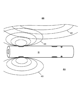
explained in the context of FIG. 6. FIG. 6 illustrates an LWD tool 22 that is
moving through a formation
404. An anomalous formation 406 is located at a distance from the LWD tool 22.
LWD tool 22 induces a
primary magnetic field 400 (for simplicity, only a representation of the
magnetic component of this field
is included) in the surrounding formation. Primary magnetic field 400
propagates in all directions with
axial symmetry. The primary magnetic field is affected by surrounding
formation 404, and thus the
measurement of the primary magnetic field detected by the receiving sensors
indicates the resistivity of
the surrounding formation 404.
Since primary magnetic field 400 is an alternating field which propagates
through the rock
media, it is partially reflected by the boundary between media of differing
resistivities. Accordingly, the
primary magnetic field is reflected by the anomalous formation 406. The
resulting reflected field 402
alters primary magnetic field 400, tilting the angle of the primary magnetic
field' s vector by an amount
that is related to the relative strength of the reflection and the distance to
the boundary between
surrounding formation 404 and anomalous formation 406. The effect of the
reflected magnetic field on
the primary magnetic field is more pronounced closer to the boundary between
the two formations, such
that a receiver sensor closer to the boundary will respond to a stronger
component of the reflected
magnetic field than a receiver sensor further from the boundary.
The receiver sensors that are oriented in the same manner as the transmitter
coils will be
primarily sensitive to the primary magnetic field. These receiver sensors will
also be sensitive to the
reflected magnetic field. In particular, these receiver sensors (e.g.,
receiver sensors 108 of FIG. 2A) will
detect the reflected magnetic field via its effect on the primary magnetic
field.
The receiver sensors (e.g., receiver sensors 112 of FIG. 2A) that are oriented
with their long axes
perpendicular to the orientation of the transmitter coils are orthogonal to
the primary magnetic field.
Accordingly, these sensors will not respond to the primary magnetic field.
However, these sensors will be
sensitive to the reflected magnetic field. Accordingly, embodiments that
include these sensors can
provide an increased sensitivity to the reflected magnetic field, relative to
the sensors that are configured
to respond primarily to the primary magnetic field.
As LWD tool 22 moves through the borehole, LWD tool 22 can detect changes in
the resistivity
of the surrounding formation. Such changes in resistivity indicate that the
surrounding formation is
CA 02743240 2011-05-10
WO 2010/053840 PCT/US2009/062794
- 8 -
changing, since different types of geological formations have different
resistivities. Thus, the presence of
an anomalous formation within the surrounding formation will cause the
detected resistivity to change as
the drill bit nears the anomalous formation. The measured resistivity can be
used to determine the type of
geological formation surrounding the drill bit, as well as the type and/or
location of anomalies within the
surrounding geological formation, as will be discussed in more detail below.
FIG. 2B shows an alternative sensor arrangement. In this example, LWD tool 22
includes four
sensors 108 that are oriented such that the long axis of each sensor 108 is
parallel to the long axis of
LWD tool 22 and each of the transmitter coils 106. Receiver sensors 108 are
sensitive to both the primary
and reflected (if any) magnetic fields.
FIG. 2C shows yet another alternative sensor arrangement. In this example, LWD
tool 22
includes four sensors 108 that are oriented such that the long axis of each
sensor 108 is perpendicular to
the long axis of LWD tool 22 and each of the transmitter coils 106. In this
example, the receiver sensors
108 are sensitive to the reflected magnetic field (if any) but not to the
primary magnetic field.
The sensor arrangements of FIGs. 2A-2C allow each set of sensors 108 and/or
112 on LWD tool
22 to simultaneously obtain measurements of the relative magnitude and/or
phase of a magnetic field at
four distinct points that are evenly distributed around the circumference of
the drill collar. Accordingly,
the magnitude and/or phase of the magnetic field surrounding LWD tool 22 can
be sensed in each of four
directions simultaneously. This allows an operator (i.e., a person controlling
the steering of a drill bit to
which LWD tool 22 is coupled) to use LWD tool 22 to determine the location of
anomalous formations,
if any, that the drill bit may be approaching in any of those four directions,
without rotating LWD tool 22.
Reducing the need to rotate the LWD tool 22 can simplify and/or speed up the
operation of LWD tool 22.
As noted above, many other sensor configurations are possible, in addition to
those shown in
FIGs. 2A-2C. For example, one alternative embodiment may employ only two
receiver sensors (or two
sets, each having two receiver sensors, where the axis of the sensors in one
set is perpendicular to the axis
of the sensors in the other set). When in use, an operator may rotate the LWD
tool 180 degrees in
between two sets of measurements at a given location, in order to obtain the
same measurements that
could be obtained simultaneously if four receiving sensors were used.
Other numbers of receiver sensors can also be included within each set, so
long as each set
includes at least two sensors. For example, some embodiments may include three
sensors, while other
embodiments include eight sensors.
As another example, instead of having each sensor within a given set of
sensors (where each set
contains sensors having substantially the same axis orientation, relative to
the axis of the drill collar) in
substantially the same cross-sectional plane of the drill collar, some sensors
in a given set are located in a
different cross-sectional plane than other sensors in the same set. Similarly,
in some alternative
embodiments, sensors from different sets may be arranged in substantially the
same cross-sectional plane
of the drill collar.
CA 02743240 2011-05-10
WO 2010/053840 PCT/US2009/062794
- 9 -
Another variation in sensor configuration can switch the location of the
transmitter coils and one
or both sets of receiver coils. Thus, some embodiments may place transmitter
coils closer to the drill bit
and receiver sensors towards the other end (furthest from the drill bit),
while other embodiments place
one or both sets of receiver sensors closer to the drill bit while placing the
transmitter coils further from
the drill bit. Similarly, in one embodiment, the transmitter coils may be
located towards the middle of the
drill collar, and one or more sets of receiver sensors may be located towards
each end of the drill collar,
such that the transmitter coils are between two sets of receiver sensors.
Still another variation in sensor
arrangement can orient the transmitter coils such that the long axis of the
transmitter coils is
perpendicular to the long axis of the LWD tool.
FIG. 3 illustrates a cross-sectional view of LWD tool 22. This view shows the
drilling mud
channel 102 passing through the middle of LWD tool 22. Four recesses, 110(a),
110(b), 110(c), and
110(d), extend into the body of LWD tool 22. These recesses are all located in
the same cross-sectional
plane. These recesses are spaced 90 degrees apart from each other around the
circumference of LWD tool
22.
A receiver sensor (e.g., one of receiver sensors 108 of FIGs. 2A and 2C) has
been inserted into
each recess. In particular, receiver sensor 108(a) is located within recess
110(a), receiver sensor 108(b) is
located within recess 110(b), receiver sensor 108(c) is located within recess
110(c), and receiver sensor
108(d) is located within recess 110(d). The receiver sensors are oriented such
that the axis of each sensor
is parallel to the axis of LWD tool 22.
A similar spacing and arrangement (now shown in FIG. 3) of sensors can be used
to hold sensors
(e.g., such as sensors 112 of FIGs. 2A and 2C) that are oriented such that the
axis of each sensor is
perpendicular to the axis of LWD tool 22. Thus, appropriate recesses to hold
sensors oriented in that
manner can be located in the same cross-sectional plane, spaced 90 degrees
apart from each other.
Different embodiments can vary from the spacing described herein. For example,
due to
imprecision in measurement and/or machining tools, it is often impractical to
attempt to obtain perfectly
even spacing. Accordingly, most embodiments allow for some margin of error
(e.g., 0.5%, 1%, or 5%,
depending on the measurement and/or machining tools available and/or the
desired accuracy of the
resulting LWD tool) in the spacing and/or orientation of the transmitting
coils and/or receiver sensors.
In some embodiments, even greater variations in spacing are used. Instead of
having each sensor
be arranged at a position that is spaced approximately 90 degrees from two
other sensors, alternative
embodiments may locate sensors around the circumference of the drill collar
using a more varied spacing.
For example, in one alternative embodiment, each sensor may be located closer
than 90 degrees (e.g., 80
degrees) to one neighboring sensor and more than 90 degrees (e.g., 100
degrees) from the other
neighboring sensor.
The position of each sensor can be mechanically keyed to a separate
directional sensor or
orientation sensor (e.g., a gyroscope). This allows the signal detected by
each sensor to be analyzed as a
CA 02743240 2011-05-10
WO 2010/053840 PCT/US2009/062794
- 10 -
component of a vector electromagnetic field, which has a direction referenced
to the gravity vector and/or
the direction of the magnetic north pole, or to an inertial reference vector.
FIG. 4 is a flowchart of a method of using a LWD tool that has a sensor
arrangement like one of
those described above, in which more than one receiver sensor independently
obtains a measurement of a
magnetic field. This method can be performed by a LWD tool 22 as described in
the figures above, in
combination with components such as those shown in FIG. 5 (if such components
are not integrated into
LWD tool 22).
The method begins at 200, when a magnetic field is induced in a formation. As
noted above,
inducing a magnetic field can involve applying a sinusoidal current to one or
more transmitter coils at a
prespecified frequency. This operation can be performed by a current generator
(e.g., an oscillator
operating under the control of a control module, which can in turn be
responsive to an operator' s
commands to take a measurement), operating in conjunction with one or more
transmitter coils that are
coupled to receive the sinusoidal current produced by the current generator.
At 205, electrical signals (e.g., a voltage induced in two or more receiver
sensors) are received.
The electrical signals indicate the magnitude and/or phase of a reflected
magnetic field at multiple
locations around the drill collar. In particular, each electrical signal
indicates the magnitude and/or phase
of a reflected magnetic field, as measured at a respective one of several
locations along the circumference
of the drill collar. These electrical signals are generated by two or more
receiver sensors and received by
components such as those shown in FIG. 5. As noted above, the magnitude and/or
phase of the reflected
magnetic field can be detected by measuring the reflected magnetic field
directly (e.g., through the use of
sensors that are oriented with their axes perpendicular to the orientation of
the transmitter coil(s)' axes) or
indirectly (e.g., through the use of sensors that are oriented with their axes
parallel to the orientation of
the transmitter coil(s)' axes, where such sensors measure the reflected
magnetic field based upon its
effect on the primary magnetic field).
At 210, a vector representation of the reflected magnetic field is calculated,
based upon the
electrical signals received at 205. This vector representation can be
calculated by a control module (e.g.,
control module 302 of FIG. 5 below), which can be included within and/or
coupled to the LWD tool. This
vector representation can then be displayed to an operator, logged, and/or
used to generate a more
sophisticated display (e.g., such as a polar display for geosteering
applications). More details regarding
the calculation of this vector representation are provided below. The vector
representation indicates the
location of (e.g., in terms of an azimuthal angle), distance to, and
resistivity of the anomaly. The latter
two components of the vector representative can be relative, such that the
vector can represent multiple
possibilities, including a less resistive anomaly closer to the LWD tool and a
more resistive anomaly
further from the LWD tool. Historical data about a formation can be used to
select a more specific
interpretation of the vector.
FIG. 5 is a block diagram of circuitry 300 that can be included within and/or
coupled to LWD
CA 02743240 2011-05-10
WO 2010/053840 PCT/US2009/062794
- 11 -
tool 22. Circuitry 300 includes a control module 302, a power amplifier 304,
one or more low-noise
amplifiers 306 (only one such low-noise amplifier is illustrated in FIG. 5;
however, one such amplifier
can be included for each receiver sensor), a switching module 308, a switching
module 312, an oscillator
310, signal mixer, detector, and filter 314, analog-to-digital converter 316,
and transmission module 318.
Circuitry 300 can also include one or more memory devices such as memory 320.
Oscillator 310, switching module 310, and power amplifier 304 operate to
enable one or more
transmitter coils in order to induce a magnetic field in a formation
surrounding the LWD tool. In
particular, oscillator 310 (or any other appropriate current generator)
generates a sinusoidal current (e.g.,
in the range of 100 ¨ 400 KHz), which is then provided to power amplifier 304
via switching module
312. In this embodiment, control module 302 controls switching module 312 in
order to select when the
sinusoidal current is provided to power amplifier 304 (e.g., the current can
only be provided when an
operator is requesting that the magnetic field be induced in the surrounding
formation for testing
purposes). Power amplifier 304 amplifies the sinusoidal current, which is then
provided to one or more
transmitter coils (not shown) in the LWD tool.
The frequency of oscillator 310 can be selected based upon the desired
responsiveness of the
LWD tool. For example, in many situations, it is desirable to maximize the
distance from the borehole at
which the LWD tool is able to sense an anomalous formation, since this will
give a driller early warning
that he may soon encounter changed formation conditions. The radial depth of
investigation is strongly
influenced by the phenomenon of "skin depth," which is a characteristic
distance that an alternating
magnetic field can penetrate into a conductive medium. The skin depth is
defined as the distance at which
an electromagnetic field has experienced a phase-shift of 45 degrees and an
attenuation of 1/e (-8.68 dB).
Skin depth may be calculated as follows:
Skin Depth, 8 (meters) = (2/co.i.t.a)1/2 (Eq. 1)
where (0 is the angular frequency (radians/second), 1.t is the magnetic
permeability of the medium
(Henries/meter), and 6 is the conductivity of the medium (Siemens/meter).
Since the field must penetrate into the formation and be reflected back to be
detected by the
receiving sensors, the field effectively makes two trips, so the attenuation
and phase-shift of the received
signal will be doubled when the investigation distance equals the skin-depth.
A practical limit for
detection distance is when the attenuation reduces signal levels below the
noise or accuracy limit of the
measurement circuits attached to the receiving coils. To maximize the skin-
depth in a given medium, one
can choose to minimize the frequency since this is the only independent
parameter. However, the
magnitude of the signal induced in a receiving sensor is proportional to
frequency, so a best compromise
must be found in the tool design. Such a compromise can be found by using a
frequency in the range of
100 ¨ 400 KHz for embodiments in which the transmitter coils are spaced a few
meters or so from the
receiver sensors. At a frequency of 200 KHz, the skin depth ranges from 0.4 to
40 meters for a typical
rock resistivity range of 0.1 to 1000 ohm-meters. Thus, the potential depth of
investigation could be at
CA 02743240 2011-05-10
WO 2010/053840 PCT/US2009/062794
- 12 -
least several meters in the higher resistivity range typical of most
hydrocarbon-bearing reservoir rocks.
A voltage, which is dependent upon the magnetic field in the surrounding
formation, can be
induced in each receiver sensor. Each of the receiver sensors (not shown) is
coupled to a respective low
noise amplifier 306, which amplifies the signal induced in the respective
receiver sensor and provides
that amplified signal to switching module 308. Control module 302 controls
switching module 308 (e.g.,
in order to select which receiver sensor' s output is input to signal mixer,
detector, and filter 314 at any
given time).
The output of switching module 308 is provided to signal mixer, detector, and
filter 314. Signal
mixer, detector, and filter 314 also receive a reference signal (fref) (e.g.,
indicating the signal provided to
the transmitter coils) from oscillator 310. Signal mixer, detector, and filter
314 can, among other things,
remove unwanted noise from the amplified signal. For example, signal mixer,
detector, and filter 314 can
remove unwanted noise from image frequencies.
Signal mixer, detector, and filter 314 provides its output to analog-to-
digital converter 316, which
in turn outputs a digital representation of the signal received from signal
mixer, detector, and filter 314 to
control module 302. Control module 302 then processes this digital signal (in
conjunction with other
digital signals representing the signals detected at the other sensors
included in the LWD tool) in order to
produce a vector representation of the reflected magnetic field. In
particular, control module 302 can
obtain the magnitude and/or phase of the signal detected at each sensor, as
well as positional information
identifying the location of each sensor (e.g., relative to the gravity vector,
magnetic North, or the axis of
the LWD tool), in order to obtain a vector representation of the magnetic
field. This vector representation
can then be used to determine the resistivity and location (e.g., in terms of
direction and distance) of an
anomalous formation. Control module 302 can also process the received digital
signals in order to
identify the resistivity of the surrounding formation in the absence of any
anomaly.
In one embodiment, the magnitude and phase of the induced voltage in a pair of
receiver sensors
(a pair includes two sensors in the same set, which includes sensors having
the same orientation, that are
spaced approximately 180 degrees apart from each other on the circumference of
the LWD tool), relative
to the current in the transmitter coil, is an accurate measure of the
electrical resistivity of the rock in a
selected location. Accordingly, the phase difference or the amplitude ratio
between signals from a pair of
closely-spaced receiver sensors (e.g., any two of the receiver sensors in a
given set of similarly oriented
receiver sensors) provides an accurate indication of rock resistivity in a
narrow slice of rock between the
sensors. Thus, control module 302 can calculate a value that is representative
of the formation resistivity,
based upon the signals received from the receiver sensors.
In particular, for a pair of sensors having axes parallel to the axis of the
transmitter coil(s), the
vector representation of the magnetic field can be calculated by calculating
the ratio of the signals
obtained by that pair of sensors. This representation also indicates the
resistivity of the formation
generally located in the axial region between the sensors. The signals
received by these sensors, which
CA 02743240 2011-05-10
WO 2010/053840 PCT/US2009/062794
- 13 -
are responsive to both the primary and reflected (if any) magnetic fields, can
be used to calculate the
resistivity of both a homogeneous geological formation and an anomalous
geological formation (if any).
If instead the pair of sensors have axes that are perpendicular to the axis of
the transmitter coil(s),
so that the sensors are only sensitive to a reflected magnetic field, if any,
the signals from these sensors
can be used to determine the resistivity of an anomalous formation (e.g., by
calculating the ratios of
signals received by pairs of sensors).
If two sets of sensors, which are oriented perpendicular to each other, are
included, the signals
received from one set of sensors (e.g., those sensors sensitive to the primary
field) can be used to
calculate the resistivity of a homogeneous surrounding geological, while the
signals received from the
other set of sensors can be used to calculate the resistivity of the anomalous
geological formation.
In general, when a receiver sensor is spaced apart from a transmitter coil,
the voltage V induced
in a receiving sensor due to a sinusoidal current I flowing in the transmitter
coil is:
V (volts) = -j coM.(1 - jkL).e .I (amperes) (Eq. 2)
where j is the imaginary operator (-1) 1/2, M is the mutual inductance between
the transmitter and receiver
(Henries), L is the spacing between the transmitter and receiver (meters), k
is the complex propagation
coefficient of the medium, k = [jcom. (a + jmE)]1/2, and E is the dielectric
permittivity of the medium
(Farads/meter).
Assuming that the dielectric permittivity of the medium has negligible effect
on propagation,
then the propagation coefficient reduces to the form:
k = (jcom.a)1/2 (Eq. 3)
k = (14/8 (Eq. 4)
Substituting this into Eq. 2 and re-arranging terms results in the simplified
form:
V/I = -j (01\4.[1 ¨ (j-1)L/81.e (1-1)L/8 (Eq. 5)
In Eq. 5, V/I represents a transfer-function between coils, jcoM represents
the low-frequency
mutual coupling, 111 ¨ (j-1 )L/81 represents the spreading effect (since this
example is focused on
operating in the near-field region of the transmitter and receivers), and e1
representsthe plane-wave
propagation in the medium.
L/8 is a dimensionless term, since it is a ratio between two physical
distances.
Control module 302 can be configured to use Eq. 5 to predict the phase-shift
and attenuation of
the transfer-function in a medium of varying conductivity. Circuitry 300 can
be configured to also use
Eq. 5 to predict the reflected field from a rock-bed boundary (e.g., the
boundary between a surrounding
formation and an anomalous formation) in proximity to the LWD tool. If the
boundary is parallel to the
CA 02743240 2011-05-10
WO 2010/053840 PCT/US2009/062794
- 14 -
tool axis and at a distance of D meters, then the total distance from
transmitter coil to the boundary and
back to the receiver sensor is a matter of geometry:
Total Distance D' = 21D2 + (L/2)211/2 (Eq. 6)
Substituting D' for L in Eq. 5 allows calculation of the reflected component
of the signal,
assuming that the reflection coefficient of the boundary is nearly -1, which
is true if there is a large ratio
(>10) between the conductivities of the two media on either side of the
boundary. If we are only
concerned with the phase of a received signal relative to the phase of the
induced primary magnetic field,
then the phase velocity of the field is constant in the medium regardless of
distance, so the phase-shift
may be simply represented as:
Phase-shift 0 = nEY/48 (Eq. 7)
If the receiver sensor is oriented in a manner (e.g., such as shown in FIG.
2C) that is only
responsive to a reflected signal from a boundary (i.e., and not to a signal in
which the reflected signal is
added to a direct signal, as shown in FIG. 2B) then it is easy to invert this
equation to determine distance
from the phase measured by that receiver sensor:
Distance to Boundary D = 1(208/702¨ (L/2)211/2 (Eq. 8)
The resistivity of the rock surrounding the tool can be determined from the
simultaneous
measurement with receiver sensors that are oriented in the same manner as the
transmitter coils (e.g., as
shown in FIG. 2B). For example, if all of those receiver sensors detect
approximately the same resistivity
value, then that value indicates the resistivity of the surrounding formation.
If the sensors begin to detect
different values, the most recent consistent (among those sensors) value can
be used as the resistivity of
the surrounding formation, and the difference among sensor outputs can be
attributed to an anomalous
formation that the LWD tool is approaching. A value indicating the resistivity
of the surrounding
formation (or a log of such values, and the time (and/or location) at which
each value was obtained) can
be stored in memory 320.
Control module 302 can use that resistivity of the surrounding formation to
compute the skin-
depth to be used in Eq. 8, and hence find the value of D. In some embodiments,
an advanced 3-
dimensional Finite-Element computer-modeling program such as FEMLABTM,
available from Comsol,
Inc. of Burlington, MA, may be employed to simulate a wide range of formation
conditions and to create
a database, allowing control module 302 to perform inversion of measured phase-
shift to actual boundary
distance using the measured phase-shift and the database of simulated
formation conditions. Such
simulated results can be stored in memory 320 (e.g., in the form of a lookup
table), allowing control
module 302 to lookup a measured phase shift and obtain an appropriate distance
to a boundary.
Thus, control module 302 can detect whether the LWD tool (and thus the drill
bit to which the
CA 02743240 2011-05-10
WO 2010/053840 PCT/US2009/062794
- 15 -
LWD tool is attached) is approaching or moving away from an anomaly. For
example, as described
above, control module 302 can compare the most recently calculated set of
apparent resistivities detected
by each sensor to historical resistivity values (e.g., generated by a computer-
modeling program) stored in
memory 320. If any of the resistivities have increased relative to the
historical resistivities, control
module 302 can determine that the LWD tool is approaching a more resistive
anomaly. Similarly, if any
of the detected resistivities have decreased relative to the historical
resistivities, control module 302 can
determine that the LWD tool is approaching a less resistive anomaly.
The output from a directional sensor included in and/or coupled to the LWD
tool can then be
used to determine the relationship between that known point and a standard
directional vector, such as
magnetic north or the gravity vector. The output from the directional sensor
can thus be provided to
control module 302, which can use this information to calculate a relative
azimuthal angle describing the
location of the anomaly relative to the standard directional vector.
More exact techniques can be used to calculate the azimuthal angle and
distance to a resistivity
anomaly using the configuration of the sensors. An example is described below
with respect to Fig. 7.
FIG. 7 illustrates a vector representation of a reflected magnetic field
(produced by, for example,
a resistivity anomaly such as a rock-bed boundary between two rocks of
contrasting resistivity) relative to
a LWD tool 22. As shown, the LWD tool 22 includes a pair of sensors, labeled X
and Z. Sensor X has a
long axis that is perpendicular to the axis 700 of LWD tool 22 and a
transmitter coil. Sensor Z has a long
axis that is parallel to axis 700 of LWD tool 22 and the transmitter coil.
The magnetic field vector (shown as a bold arrow pointing towards LWD tool 22)
approaches
LWD tool at a relative angle 0 that is defined with respect to axis 700 of LWD
tool 22. The magnetic
field vector is normal to the surfaces of constant magnetic field strength,
and indicates the general
direction of a resistivity anomaly such as a bed-boundary that attenuates and
reflects a magnetic field
generated by a transmitter within LWD tool 22.
A voltage is induced in each of sensors X and Z by the magnetic field. The
voltage induced in
sensor X is Vx and the voltage induced in sensor Z is Vz. These voltages can
be used to calculate the
relative angle 0 as the arctangent of the ratio of Vx to Vz, such that 0 =
arctangent (vx / Vz). This angle
represents the relative angle in the plane defined by the X and Z axis. This
technique allows the relative
angle to be detected, while also providing a robust LWD tool assembly since
very little metal needs to be
removed from the circumference of the collar to allow for insertion of the
sensors.
If there is a similarly oriented sensor Y (not shown in FIG. 7), located 90
away from sensor X
along the circumference of LWD tool 22 and having its long axis perpendicular
to the Z sensor axis (and
thus being oriented similar to sensor X), a second angle 0 can be calculated
as the arctangent of the ratio
of the voltage Vy induced in sensor Y to Vz, such that 0 = arctangent (Vy VA
This angle represents the
relative angle of the vector in a plane defined by the Y and Z axis.
CA 02743240 2011-05-10
WO 2010/053840 PCT/US2009/062794
- 16 -
The two angles together specify the direction of the magnetic field vector
relative to axis 700 of
LWD tool 22. In some embodiments, additional calculations can be applied to
the calculated angles
and/or during the calculation of these angles. For example, the voltages
induced in the sensors can be
scaled to account for differences in the gain of each of the sensors, and also
to correct for the influence of
the conductive drill collar of LWD tool 22, which can perturb the magnetic
field detected by all or some
of the sensors. The corrections can be derived from computer modeling of the
performance of LWD tool
22 in various situations.
The two angles can be combined with the distance estimate described above to
provide a
complete vector representation, in terms of distance, magnitude, and angle, of
the magnetic field. The
magnitude Vm of the magnetic field is equal to the square root of the sum of
Vx squared, Vy squared, and
Vz squared. Again, certain scaling factors can be applied to the component
voltages prior to calculating
Vm, depending upon the particular configuration of the sensor coils being
used.
Another more general solution of the measured voltages Vx, Vy, and Vz in a
polar coordinate
system is more useful in some situations. We define an azimuthal angle (here,
an angle of rotation around
the Z axis relative to a fixed reference-point) as AZI, and an angle relative
to the Z axis in any azimuthal
direction (i.e., a relative bearing) as RB. Then AZI = arctangent (Vy V) and
RB = arccosine (Vz / V11).
With this solution, it is not necessary to rotate the drill-collar to obtain a
complete solution of the
direction of the magnetic vector.
Using the AZI angle and the Distance D as described previously, the data
presentation method
described in copending U.S. Patent Application Serial No. 11/756,504, titled
"Azimuthal Measurement
While Drilling (MWD) Tool," filed May 31, 2007, and naming Paul L. Sinclair
and Thomas A. Springer
as inventors, can be used to generate a polar display.
Returning to FIG. 5, transmission module 318 is configured to communicate
information
received and/or calculated by control module 302 to another sub or to a
surface system. For example,
transmission module 318 can receive information generated by control module
302 (e.g., by receiving the
information directly from control module 302 or by retrieving such information
from a storage device
such as memory 320) that indicates the resistivity of the surrounding
formation and transmit this
information to a surface system. Alternatively, transmission module 318 can
transmit information
indicative of the magnitude and/or phase of the reflected electromagnetic
field detected at each sensor to
a surface system, allowing the surface system to calculate the resistivity of
the surrounding formation
from the data collected by LWD tool 22.
Transmission module 318 can also receive information sent to control module
302 by a surface
system and/or another sub. For example, transmission module 318 can receive
information indicating that
a surface user would like LWD tool 22 to begin measuring the resistivity of
the surrounding formation.
Transmission module 318 can provide this information to control module 302
and/or store this
information for subsequent access by control module 302. Transmission module
318 can be configured to
CA 02743240 2011-05-10
WO 2010/053840 PCT/US2009/062794
- 17 -
interface to and/or communicate via a wire line cable (e.g., wire line cable
24 of FIG. 1), a telemetry
system, or any other desired communication system and/or communication media.
In some embodiments, at least some of the components shown in FIG. 5 are
included within the
drill collar implementing LWD 22. For example, at least some of these
components can be placed within
one or more cavities within the drill collar. Alternatively, all or some of
these components can be located
within a cartridge that is configured to be coupled to or located within the
drill collar (e.g., such a
cartridge can be suspended within the drilling mud channel). In one
embodiment, such a cartridge
includes components such as electronic circuits, communication circuits,
directional sensors (e.g.,
configured to detect a standard directional vector, such as the gravity vector
or magnetic North), and the
like. In some embodiments, this inner cartridge is retrievable, such that the
inner cartridge can be
installed and/or withdrawn from LWD tool 22 while LWD tool 22 is below the
surface. For example, the
inner cartridge can be installed or withdrawn through the drillstring using a
slick line cable or wireline
attached to the upper end of the LWD tool. The drillstring can include a
muleshoe (not shown) to accept
and orient the inner cartridge in such an embodiment.
While certain components are shown as part of the LWD tool in FIG. 5, it is
noted that in
alternative embodiments, such components can be implemented within other subs
within the drillstring
and/or other components within the drilling system. For example, the
transmission module 318 and/or
directional sensors (not shown) can each be implemented within another sub.
Similarly, all or part of the
functionality of control module 302 can be implemented within another sub or
within a surface
computing device (e.g., a laptop computer). For example, in one embodiment, a
portion of control
module 302 (e.g., the portion that calculates the vector representation of the
electromagnetic field
detected at each sensor) is implemented in software executing on a computer
system located at the
surface. Another portion of the control module 302 (e.g., the portion that
controls the operation of
oscillator 310, switching module 312, analog-to-digital converter 316, and
transmission module 318) can
be implemented in hardware, firmware, and/or software residing in LWD 22.
Alternatively, in some embodiments, an LWD tool may store and transmit only
the digitized raw
measurements from the sensors, for more detailed computations using a computer
at a surface location,
and thus the majority, or even all, of control module 302 may be implemented
at such a surface computer.
In still other embodiments, the LWD tool will be designed to process and
transmit some of the data as
described, but due to the limited data-rate of transmission available, the
complete set of measured data
will be stored (e.g., in Flash Memory) within the tool for later download to a
surface computer when the
borehole assembly is returned to the surface (e.g., during a bit run).
While specific equations have been described in the above description of FIG.
5, it is noted that
other embodiments can implement different equations. For example, a LWD tool
having six sensors will
use different equations than those presented above, which are designed for use
with a LWD tool having
four sensors.
CA 02743240 2011-05-10
WO 2010/053840 PCT/US2009/062794
- 18 -
It is noted that all or some of the control module 302 shown in FIG. 5 can be
implemented in
software executing on a computing device (e.g., a personal computer, server,
personal digital assistant,
cell phone, laptop, workstation, or the like). In particular, such a computing
device includes one or more
processors (e.g., microprocessors, PLDs (Programmable Logic Devices), or ASICs
(Application Specific
-- Integrated Circuits)) configured to execute program instructions stored in
a memory. Such a memory can
include various types of RAM (Random Access Memory), ROM (Read Only Memory),
Flash memory,
and the like. The computing device can also include one or more interfaces
(e.g., such as network
interfaces, one or more interfaces to storage devices, and/or one or more
interfaces to an input / output
(I/0) device such as a keyboard, digital tablet, mouse, monitor, or the like),
which can each be coupled
-- (e.g., by a bus or other interconnect) to the processor(s) and memory.
It is noted that the program instructions and data (e.g., such as a history
log and/or lookup table)
consumed by and/or implementing all or part of control module 302 can be
stored on various computer
readable media such as memory 320. In some embodiments, such program
instructions can be stored on
a computer readable storage medium such as a CD (Compact Disc), DVD (Digital
Versatile Disc), hard
-- disk, optical disk, tape device, floppy disk, and the like. In order to be
executed by a processor, the
instructions and data are loaded into memory from the other computer readable
storage medium. The
instructions and/or data can also be transferred to a computing device for
storage in memory via a
network such as the Internet or upon a carrier medium.
FIG. 8A illustrates how a sensor can be placed in the wall of a LWD tool 22.
The view in FIG.
-- 8A looks at the surface of the drill collar, and the long axis of the
sensor is represented by the dashed
arrow. FIG. 8B shows a cross-sectional view of the drill collar, when viewed
in direction A-A marked on
FIG. 8A. As shown in these figures, a meandering channel 820 has been formed
in the drill collar. In
addition, a cross-drilled hole 840 provides a location for a receiver sensor,
as shown in cross-section in
FIG. 8B, and the combination of the meandering channel 820 and the hole 840
operatively breaks the
-- path of continuous metal around sensor 830. A wiring channel 810 connects
this channel to an electrical
connector 800, which can provide a voltage induced in a receiver sensor 830
disposed in a transverse hole
840 in the drill collar to other circuitry (e.g., circuitry 300 of FIG. 5) for
further processing.
Meandering channel 820 and wiring channel 810 can be filled with non-
conducting material,
such as a composite epoxy/ceramic material or an elastomer which surrounds and
protects a receiver
-- sensor 830 in hole 840, and wires (in wiring channel 810) coupling the
receiver sensor to electrical
connector 800.
Using a meandering channel (as opposed to a non-meandering channel having the
maximum
width and length of the meandering channel) retains more of the metal of the
drill collar. By retaining
more of the metal in the drill collar, the drill collar's strength can be
relatively less affected by the
-- inclusion of the receiver sensor. Additional, the retained metal can
provide increased protection to
receiver sensor 830 from abrasions and impacts that occur during drilling. At
the same time, the
CA 02743240 2011-05-10
WO 2010/053840 PCT/US2009/062794
- 19 -
meandering channel ensures that there is no electrically conductive path
around receiver sensor 830. If
present, such an electrically conductive path could short-circuit receiver
sensor 830.
FIGs. 8A and 8B show how a sensor having its long axis perpendicular to the
axis of the drill
collar can be protected by a meandering channel machined into the surface of
the drill collar. A similar
configuration, rotated 90 with respect to the orientation of the sensor axis
shown in FIG. 8A, can be
used to protect a sensor having its long axis parallel to the axis of the
drill collar.
Although the present invention has been described in connection with several
embodiments, the
invention is not intended to be limited to the specific forms set forth
herein. On the contrary, the present
invention is intended to cover such alternatives, modifications, and
equivalents as can be reasonably
included within the scope of the invention as defined by the appended claims.
INDUSTRIAL APPLICABILITY
Embodiments of the present invention can be used in the field of natural
resource exploration,
discovery, and/or extraction.