Note: Descriptions are shown in the official language in which they were submitted.
CA 02744050 2015-10-13
79700-68
CONTINUOUS ADAPTIVE SURFACE WAVE ANALYSIS FOR
THREE-DIMENSIONAL SEISMIC DATA
[001]
BACKGROUND
[002] The invention generally relates to continuous surface wave analysis for
three-
dimensional seismic data.
[003] Seismic exploration involves surveying subterranean geological
formations for
hydrocarbon deposits. A survey typically involves deploying seismic source(s)
and seismic
sensors at predetermined locations. The sources generate seismic waves, which
propagate
into the geological formations creating pressure changes and vibrations along
their way.
Changes in elastic properties of the geological formation reflect, refract or
scatter the seismic
waves, changing their direction of propagation and other properties. Part of
the energy
emitted by the sources reaches the seismic sensors. Some seismic sensors are
sensitive to
pressure changes (hydrophones), others to particle motion (e.g., geophones),
and industrial
surveys may deploy only one type of sensors or both. In response to the
detected seismic
events, the sensors generate electrical signals to produce seismic data.
Analysis of the
seismic data can then indicate the presence or absence of probable locations
of hydrocarbon
deposits.
[004] For a land-based seismic survey, the seismic waves include surface waves
and
body waves. The surface waves propagate without radiation into the Earth's
interior, are
parallel to the Earth's surface and have a reduced geometric spreading as
compared to the
body waves. The surface waves carry a significant part of the energy that is
radiated by a
seismic source at the Earth's surface.
[005] Surface waves constitute most of the coherent noise in seismic data. In
this
manner, the surface waves are source-generated events that are characterized
by relatively
low velocity and relatively high amplitudes, and the surface waves superimpose
onto the
useful signal. This coherent noise (often called ground roll in land seismic
applications) may
1
CA 02744050 2015-10-13
79700-68
be in the form of many different wave types, such as Rayleigh waves with
multiple modes of
propagation, Lamb waves, P-guided waves, Love waves and Scholte waves.
[006] The propagation properties of surface waves depend on the elastic
properties of
the "near- surface," the shallow portion of the Earth, which is responsible
for most of the
perturbation and degradation of the acquired seismic data. For purposes of
designing filters to
attenuate surface wave noise, it is generally important to accurately identity
the properties of
the surface waves. Additionally, knowledge of the surface wave properties may
be beneficial
for other purposes, such as determining the local elastic properties of the
near surface and
estimating static corrections.
SUMMARY
[007] In an embodiment of the invention, a technique includes receiving
seismic data
acquired in a survey of a region, the region being associated with locations;
processing the
seismic data to estimate at least one frequency dependent surface wave
property over the
region; based at least in part on the estimated frequency dependent surface
wave property(ies),
determining a frequency dependent data processing geometry for each location;
and
processing the seismic data based at least in part on the determined data
processing
geometries to derive a spatially continuous representation of a surface wave
property across
the region.
[007a] According to one aspect of the present invention, there is provided a
method
comprising: receiving seismic data acquired by receivers in a survey of a
region, the region
having a plurality of locations; processing the seismic data to estimate a
frequency dependent
surface wave property over the region; locally determining frequency dependent
data
processing geometries across the region, comprising determining a frequency
dependent data
processing geometry for each location based at least in part on said estimated
frequency
dependent surface wave property evaluated at said each location, the frequency
dependent
data processing geometry identifying a geometry-based selection of the
receivers; and
processing the seismic data in a processor-based machine based at least in
part on the
2
CA 02744050 2015-10-13
79700-68
determined data processing geometries to derive a spatially continuous
representation of the
surface wave property across the region.
[007b] According to another aspect of the present invention, there is provided
a
system comprising: an interface to receive seismic data acquired by receivers
in a survey of a
region, the region having locations; and a processor to: process the seismic
data to estimate a
frequency-dependent surface wave property over the region; locally determine
frequency
dependent data processing geometries across the region by determining a
frequency-
dependent data processing geometry for each location based at least in part on
said estimated
frequency dependent surface wave property evaluated at said each location, the
frequency
dependent data processing geometry identifying a geometry-based selection of
the receivers;
and process the seismic data based at least in part on the determined data
processing
geometries to derive a spatially continuous representation of the surface wave
property across
the region.
[007c] According to still another aspect of the present invention, there is
provided an
article comprising a computer readable storage medium storing instructions
that when
executed by a computer cause the computer to: receive seismic data acquired by
receivers in a
survey of a region, the region having locations; process the seismic data to
estimate a
frequency-dependent surface wave property over the region; locally determine
frequency
dependent data processing geometries across the region by determining a
frequency-
dependent data processing geometry for each location based at least in part on
said estimated
frequency dependent surface wave property evaluated at said each location, the
frequency
dependent data processing geometry identifying a geometry-based selection of
the receivers;
and process the seismic data based at least in part on the determined data
processing
geometries to derive the spatially continuous representation of the surface
wave property
across the region.
[008] Advantages and other features of the invention will become apparent from
the
following drawing, description and claims.
2a
CA 02744050 2011-05-17
WO 2010/062836 PCT/US2009/065347
BRIEF DESCRIPTION OF THE DRAWING
[009] Figs. 1 and 3 are flow diagrams depicting techniques to determine a
spatially
continuous three-dimensional representation of a surface wave property over a
survey region
according to embodiments of the invention.
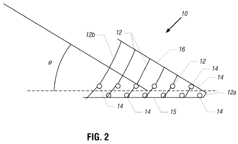
[0010] Fig. 2 is a schematic diagram illustrating an exemplary local data
processing
geometry for a given frequency according to an embodiment of the invention.
[0011] Fig. 4 is a schematic diagram of a seismic survey array illustrating
offset and
azimuth constraints for an exemplary local data processing geometry according
to an
embodiment of the invention.
[0012] Figs. 5A and 5B are schematic diagrams depicting exemplary adaptive
offset
selection and transforms according based on frequency-dependent wave
propagation
properties according to an embodiment of the invention.
[0013] Fig. 6 is a schematic diagram of a three-dimensional swath seismic
acquisition
geometry according to an embodiment of the invention.
[0014] Fig. 7 is a schematic diagram of a data processing system according to
an
embodiment of the invention.
3
CA 02744050 2011-05-17
WO 2010/062836 PCT/US2009/065347
DETAILED DESCRIPTION
[0015] Techniques are described herein to construct a spatially continuous
three-
dimensional (3-D) representation of surface wave properties (such as velocity
or attenuation,
as examples) using seismic data acquired from an arbitrary seismic acquisition
geometry.
Surface wave properties that are determined using the techniques that are
disclosed herein
may be used in a number of different applications, such as near surface
modeling, static
correction estimation, perturbation correction, noise filter design, shallow
drilling hazard
mapping, etc.
[0016] As described below, the surface wave properties are first independently
determined at given locations of the surveyed region (at the receiver
locations, for example)
to produce corresponding spatially continuous pseudo sections of the surface
wave property.
The pseudo sections are then merged to produce the 3-D representation of the
surface wave
property across the surveyed region. As described herein, for purposes of
determining the
surface wave properties at each location, a frequency-dependent data
processing geometry is
first determined for the location based on an adaptive process that considers
frequency-
dependent surface wave property estimates. The data processing geometries
govern the
selection of traces that are processed to determine the surface wave
properties.
[0017] Referring to Fig. 1, in accordance with a more specific example, a
technique
100 may be used to process seismic data acquired by a seismic acquisition
array that has an
arbitrary geometry to generate a spatially continuous 3-D representation of a
given surface
wave property. The technique 100 includes first processing the seismic data to
estimate
surface wave properties over the surveyed region, as set forth in block 104.
This step may
includes identifying average surface wave properties, including identifying
the wave type
(i.e., Rayleigh waves, Love waves, Scholte waves, P-guided waves, etc.),
identifying the
wave modes and identifying the frequency and velocity ranges of the surface
wave. It is
noted that the surface wave may be a composite wave that is formed from more
than one type
of fundamental surface wave.
[0018] Next, the technique 100 includes determining (block 108) a frequency-
dependent data processing geometry for each location (each receiver location,
for example)
of the surveyed region. The data processing geometry defines a sub-array of
the overall
survey acquisition array. The traces from the sub-array are processed to
determine the
surface wave property for the associated location. The data processing
geometry may be
4
CA 02744050 2011-05-17
WO 2010/062836 PCT/US2009/065347
defined by, for example, an azimuthal range and an offset range; as further
described below,
these ranges vary with frequency. As also described further below, for each
location, the
offset range, azimuthal range, the maximum wavenumber and the frequencies are
selected,
based on such factors as the spatial sampling of the source-receiver offset,
the amplitude
spectrum of the seismic data, lateral variations in the surface wave property
near the location,
the desired spatial resolution, the desired signal-to-noise ratio (SNR), the
size of the geometry
and the degree of overlap between adjacent geometries.
[0019] If the surface wave property is locally homogenous in an area that
contains a
given sub-array, then the local surface wave properties may be expressed as a
function of the
source to detector offset. The area influencing the wave propagation is
limited to a small
neighborhood of the location. As further described below, the data selection
is adaptive such
that for each location, different traces are selected for each frequency or
frequency band to
minimize near field effects and exclude far offsets.
[0020] As a more specific example, Fig. 2 depicts an exemplary data processing
geometry 10 for a given location for a given frequency. Boundaries of the data
processing
geometry 10 are defined by an azimuth 0, which delineates the wavefronts that
are analyzed
for the location. An offset range is also selected as a parameter of the data
processing
geometry 10. The offset selection includes a frequency dependant minimum and
maximum
offset, to take into account the near field and the attenuation. In this
regard, exemplary
offsets 12 and are depicted in Fig. 2. For example, the data processing
geometry 10 for the
location may be constrained between offsets 12a to 12b and between azimuthal
lines 15 and
16. Other azimuths 0 and offsets 12 may be used for other data processing
geometries, as the
data processing geometry is designed for each specific receiver/source
location, in
accordance with some embodiments of the invention.
[0021] Still referring to the technique 100 in Fig. 1, the technique 100
further includes
determining (block 112) a local estimate of the propagation parameters at each
location given
the associated data processing geometry. More specifically, for each group of
receivers/sources associated with the data processing geometry, the shot
gathers that conform
to the associated data processing geometry are selected. For each shot or
receiver gather, a
wavefield transform is applied to map data from the time-source offset (t-x)
domain into the
frequency-wavenumber (f-k) domain. A high resolution transform may then be
applied
without the need of a regular spacing in the original domain. The properties
of the estimated
spectra can vary with the frequency, including the maximum wavenumber and the
spectral
CA 02744050 2011-05-17
WO 2010/062836 PCT/US2009/065347
resolution. The spectra are stacked, and the propagation parameters are then
extracted. The
same approach may be applied to common receiver gathers. For attenuation
properties, a
local regression of the spectral amplitude may then be performed. The adaptive
nature of the
workflow allows the optimal selection of data also for the estimation of the
attenuation.
[0022] The technique 100 further includes, pursuant to block 116, performing
joint
interpolation and spatially smoothing the determined local properties for
purposes of deriving
the continuous 3-D spatial representation of the surface wave properties. This
operation
considers the mutual correlation of the local properties and their spatial
correlation due to the
scale of the site lateral variations and also considers the overlap between
adjacent data
processing geometries 10.
[0023] It is noted that blocks 108, 112 and 116 may be repeated for each wave
mode
and wave type.
[0024] Depending on the particular embodiment of the invention, several
different
types of propagation parameters may be extracted from the surface wave data.
For the
examples described herein, dispersion curves (called "V(0") and attenuation
curves (called
are the propagation parameters that are considered.
[0025] Because the surface wave is dispersive, a single propagation velocity
cannot
be used to describe the wave speed. For each individual mode, a phase velocity
and group
velocity therefore exists; and the complete description of the wave speed
requires specifying
the dispersion curve (phase or group) in the entire frequency band. The phase
and group
velocities are related, and as such, one may be determined from the other.
[0026] The dispersion curves V(f) may be used to filter data with different
approaches, such as frequency-wavenumber (f-k) filtering, phase matching,
etc., and may
also be used to estimate the near-surface velocity profile at the considered
location.
[0027] In accordance with some embodiments of the invention, the velocity
(called
"V") may be expressed as follows:
V = v
ph(f) 5 Eq. 1
where "vph (f)" represents the phase velocity.
[0028] Similarly, the intrinsic attenuation D(f) depends on the wavenumber,
and the
attenuation coefficient is frequency dependent. The intrinsic attenuation
term, for every
single mode, may be written as follows:
6
CA 02744050 2011-05-17
WO 2010/062836 PCT/US2009/065347
Eq. 2
,
where " e-a(f )x " represents the attenuation coefficient.
[0029] A damping ratio curve (called "D(f)") may be regarded as a local
propagation
parameter. The D(f) damping ratio (and the quality factor Q = 0.5 D-1) is
frequency
dependent because of the different penetration of the different frequencies.
[0030] Regarding the design of the data processing geometries, the size of
each
individual group of receivers used for a particular data processing geometry
is designed to
extract the propagation parameters for the determined lateral variations and
the desired lateral
resolutions. A minimum size and number of receivers may be designed and used
as a
selection criterion, in accordance with some embodiments of the invention. For
example, in a
3-D geometry, for a receiver line, exact groups of receivers may be extracted
with a
maximum size in the in-line and cross-line directions.
[0031] As a more specific example, Fig. 3 depicts a flow diagram 120
illustrating a
technique to derive the spatially continuous 3-D representation of a surface
wave property,
according to an embodiment of the invention. Pursuant to the technique 120,
mode
identification is performed (block 124) in a few selected shot gathers. In
this regard, selected
shot gathers that span a relatively large offset range may be selected in
order to analyze and
classify the near surface modes. More specifically, the selected shot gathers
are analyzed to
detect the presence of multiple modes, their phase velocity and attenuation.
Shot gathers may
be analyzed using wavefield transforms such as the frequency-wavenumber (f-k)
transform,
followed by the tracking of energy maxima. As a non-limiting example, the
Rayleigh wave
dispersion curve may be inverted to obtain a preliminary near surface model as
an input for
the simulation of the complete near surface wavefield. Modeled modes may be
compared
with the measured modes to identify events.
[0032] After the mode identification, the technique 120 includes performing
(block
128) a preliminary assessment of the propagation properties and identifying
the lateral
variation in the few selected shot gathers In this regard, for each the
different modes and/or
wave types, frequency and velocity ranges are identified. The phase and group
velocities are
determined, and the attenuation is estimated. The offset range within which
the event to be
analyzed is present at a sufficiently large SNR is then estimated. Lateral
variations within the
selected gathers may be analyzed using, as non-limiting examples, phase
analysis or short-
space f-k transforms. The preliminary assessment of the scale of lateral
variations is carried
7
CA 02744050 2011-05-17
WO 2010/062836 PCT/US2009/065347
out, and the result is compared to other information, such as non-seismic
methods and remote
sensing data.
[0033] The technique 120 includes selecting (block 132) the modes and/or wave
types
to be analyzed and for each mode/wave type to be analyzed, determining the
data processing
geometry for each location, pursuant to block 132. The geometry is a
compromise between
obtaining increased spectral resolution and the spatial resolution that is
required by lateral
variations.
[0034] As an example, referring to Fig. 5A in conjunction with Fig. 3, the
selected
offsets at a particular location vary spatially and with frequency, as
depicted in an exemplary
data processing geometry 180. Fig. 5B depicts the corresponding data
processing geometry
180 in frequency-wavenumber (f-k) space. As can be seen in Figs. 5A and 5B,
the adaptive
selection and computation allows a higher lateral resolution in the high
frequency range
where shorter wavelengths (larger wavenumbers) are recorded and a higher
accuracy at lower
frequencies where longer wavelengths (smaller wavenumbers) are recorded. More
specifically the near field effects decrease with frequency, thereby leading
to the exclusion of
the smaller offsets at lower frequencies, as depicted in Fig. 5A. Due to
greater signal
degradation at larger frequencies, far offsets are excluded more at the higher
frequencies, as
also depicted in Fig. 5A. The size of the array of the geometry, the overlap
between adjacent
acquisition geometries and the minimum and maximum source offset may be
specifically
considered in designing the data processing geometry, in accordance with some
embodiments
of the invention. Furthermore, considering the geometry of data to be
processed, the
minimum and maximum azimuths are also determined. Widening the azimuth range
increases the number of shots or receivers that are considered for each
location, thereby
increasing the robustness of the estimate. The presence of azimuthal
anisotropy can be
assessed considering the full azimuth range and comparing results for
different azimuths bins.
However, at the same time, the computation time and the impact of anomalies,
which are not
located exactly below the receivers of the data processing geometry increase.
[0035] Thus, for each location, a set of shot gathers or receiver gathers are
selected,
pursuant to block 136; and for a given location, the data fulfilling the
different criteria
according to the data processing geometry are selected. For example, in a
cross-spread 3-D
geometry, for each location along a receiver line or along a macro-line made
of multiple sub-
lines, the traces that are considered are all shot points within the designed
offset and azimuth
ranges. Similarly, for selection of common receiver gathers with a source
array along a
8
CA 02744050 2011-05-17
WO 2010/062836 PCT/US2009/065347
source line, the offset and azimuth ranges are used. For a macro-line made of
several sub-
lines, a group of detectors is extracted around a given location, and a set of
sources from a
range of offsets and azimuths are selected, as depicted in Fig. 4.
[0036] In this regard, also referring to Fig. 4, the seismic survey array 150
includes
receiver sub-lines 160 and source lines 154. The source and receiver locations
for a given
location 171 are constrained by requiring the offsets to be constrained
between a radius 172
and a radius 176, and the locations are also constrained by an azimuthal
range, defined
between lines 164 and 168. The azimuthal anisotropy can be assessed evaluating
the
properties across different azimuth bins.
[0037] Therefore, the net result of block 136 is the derivation of a frequency
dependent data processing geometry for each location.
[0038] Still referring to Fig. 3, next, for each location, each shot/receiver
gather is
transformed in the time-source offset domain to produce a high resolution
wavefield
transform, pursuant to block 140. The transform data are stacked, and maximum
tracking is
used to derive the dispersion curves.
[0039] As a more specific example, in accordance with some embodiments of the
invention, for each location, an unevenly spaced high-resolution wavefield
transform is
determined, such as the Multiple Signal Classification (MUSIC) algorithm that
is set forth in
Schmidt, R.O., Multiple Emitter Location and Signal Parameter Estimation, IEEE
TRANSACTIONS ON ANTENNAS PROPAGATION, Vol. AP-34, 276-280 (1986). The
transform is
applied to different datasets, consisting of traces fulfilling different
criteria of minimum and
maximum offset, for each frequency or frequency band. The output parameters
are designed
according to the expected maximum wavenumber and required spectral resolution
(wavenumber discretization) and are frequency dependent.
[0040] The wavefield transform transforms the acquired data from the space to
the
wavenumber domain, and a standard Fast Fourier Transform (FFT) may be used to
transform
the data from the time domain into the frequency domain, as depicted in block
142. Muting
may be applied on gathers before the transformation to remove energy from
outside the
surface wave signal cone. A stacked spectrum may then be computed by averaging
all
individual contributions, and a weighted summation may then be performed,
considering the
quality of the data. The maxima are tracked in the stacked spectrum, such as
by using the
9
CA 02744050 2011-05-17
WO 2010/062836
PCT/US2009/065347
same picking algorithm in the individual spectra to estimate uncertainties via
statistical
analysis of the picks distribution.
[0041] Next, pursuant to the technique 120, for each location, the dispersion
and
attenuation curves are determined, pursuant to block 144. In this manner, for
each location
and for each gather, the spectral amplitudes are determined. At each
frequency, a regression
may be performed to compute the attenuation coefficient. The attenuation for
an individual
mode, may be expressed as follows:
1
21(x, f)= A0 (f) = ( ) )
e-D f =X=K f 5 Eq. 3
where " A(x, f)" represents the attenuation, "A, (f)" represents the
attenuation for zero
offset. Equation 3 may be rewritten as follows:
log(VT- f))= log(A0(if))¨ D(if). K(if). X
Eq. 4
The logarithm of the amplitude, corrected with the square root of the offset,
is a linear
function of the offset. The slope a(if) may be determined as follows:
a(if)= D(if). K(if). Eq. 5
[0042] The attenuation curve A(if) is determined and then merged with the
dispersion curve to determine the damping ratio D(f). The attenuation
coefficients and
residuals of the amplitude are stored to determine the average attenuation
curve, and the
statistics of the residuals indicate the perturbations.
[0043] Finally, pursuant to the technique 120, the dispersion curves and
attenuation
curves are interpolated to build the pseudo sections, and the pseudo sections
are integrated to
form the spatially continuous 3-D representation of the surface wave
properties, pursuant to
block 148. In this regard, at each considered location, a set of dispersion
and attenuation
curves are determined, and the determined curves are associated to the center
of the data
processing geometry. The results obtained for the different locations are then
merged to
obtain a continuous smooth spatial representation of the surface wave
properties. Due to the
spatial structure and correlation and due to the overlap between adjacent
geometries used in
the computation, the obtained image has a lateral smoothness, function of the
frequency, and
this property is used to eliminate outliers and noisy portions. The overlap is
frequency
dependent, as a result of the adaptive workflow, and mirrors the physical
lateral resolution of
CA 02744050 2015-10-13
79700-68
the different wavelengths. The mutual correlation between velocity and
attenuation may be
used to improve the regularity. The lateral smoothness constraints are relaxed
at locations
where sharp lateral variations are expected to appear.
[0044] Referring to Fig. 6, as an example, in a swath acquisition array 200, a
set of
perpendicular source 220 and receiver 230 lines are used to form corresponding
sets of
pseudo-sections. As depicted in Fig. 6, the source 220 and receiver 230 lines
may be
arranged in a grid 210 as shown in Fig. 6.
[0045] Among the advantages that may be achieved using the system and
techniques
that are described herein, a spatial distribution of the surface wave
properties may be
obtained using any geometry. The techniques and systems permit the processing
of pseudo
sections of the surface wave properties below each receiver line and each
source line with
normal 3-D geometries. The obtained properties may be used for such purposes
as near
surface modeling, static corrections, the calibration of local filters for
filtering out coherent
noise and for purposes of producing synthetic noise for filtering procedures.
[0046] Referring to Fig. 7, in accordance with some embodiments of the
invention, a
data processing system 520 may include a processor 550 that is constructed to
execute at least
one program 544 (stored in a memory 540) for purposes of processing seismic
data to
perform one or more of the techniques that are disclosed herein. The processor
550 may be
coupled to a communication interface 560 for purposes of receiving seismic
data acquired in
a seismic survey. In addition to storing instructions for the program 554, the
memory 540
may store preliminary, intermediate and final datasets involved in the
techniques that are
disclosed herein. Among its other features, the data processing system 520 may
include a
display interface 570 and display 574 for purposes of displaying the various
curves and
models that are generated as described herein.
[0047] While the present invention has been described with respect to a
limited
number of embodiments, those skilled in the art, having the benefit of this
disclosure, will
appreciate numerous modifications and variations therefrom. It is intended
that the appended
claims cover all such modifications and variations as fall within the scope of
this present invention.
11