Note: Descriptions are shown in the official language in which they were submitted.
CA 02746839 2011-07-19
SATELLITE-BASED AUTOMATIC STEERING SYSTEM
Technical Field
[0001] The present disclosure relates to automatic steering and navigation
systems, and
particularly to improvements in systems of such types which use satellite-
based position
data.
Background
[0002] Satellite based navigation systems such as the Global Positioning
System (GPS)
and other global navigation satellite systems (GNSSs), and other navigation
systems
implemented using remote sensors, are useful for the control, including
particularly the
automated navigation, of vehicles. Such navigation systems have been used, for
example,
for the automatic steering of vehicles, including rubber-tied gantry (RTG)
cranes, lawn
mowers, and tractors, and other automated ground vehicles over redundant,
replicable or
otherwise pre-defined paths. Navigation of such vehicles may include
automatically
matching a trajectory of a vehicle to a pre-mapped path or otherwise desired
pre-
determined path. Navigation systems suitable for use in implementing such
systems may
include, for example, GNSSs and/or other satellite-based systems, and local
systems
using for example transmitters emitting positioning signals from known
positions inside
buildings, etc. Examples of GNSSs may include, for example, the Galileo
positioning
system, the GLONASS navigation system, and the Compass navigation system,
among
others.
[0003] In a variety of ways, improvements in satellite- and other remote-
sensor based
automatic navigation are desirable, both with respect to the quality of the
navigation
processes (e.g., with respect to the accuracy and/or reliability of
navigation, and the
stability of navigated vehicles) and in the application of such processes to
broader ranges
of vehicle types - including, for example, transit buses, passenger aircraft,
and other
vehicles which it may be desirable to guide over predefined paths reliably,
with high
accuracy.
CA 02746839 2011-07-19
-2-
Summary
[0004] In various aspects, the invention provides systems, methods, and
machine-
interpretable coding and/or other instruction products, such as stored
software or other
computer programming, useful for the generation of signals representing
automatic
steering, or other navigation control, commands, using satellite and/or other
sensor data.
Such systems, methods and/or instruction products may, for example, be
suitable for use
in the automatic steering of vehicles in known proximity to stationary (or
substantially or
relatively stationary) base station(s). Such vehicles may, for example, be
equipped with
single or multiple satellite sensors (e.g., GPS or other GNSS sensors) and
transceivers
adapted for receipt and processing of signals from GNSS satellites.
[0005] In various embodiments, the invention provides methods, machine-
interpretable
coding for causing a processor of a vehicle controller to generate, using
known position
associated with a base station and signals received from a GNSS receiver
located at the
base station, a satellite observation error estimate; generate, using the
satellite
observation error estimate and a position of vehicle determined using signals
received
from a GNSS receiver mounted on the vehicle, at least one control signal
representing a
navigation command executable by at least one control device of the vehicle;
and to
output the control signal for execution by the control device; and
corresponding
automatic control systems.
[0006] In various embodiments, the invention provides very high precision and
accuracy
- for example, better than 2 cm positioning error in horizontal components,
with 99.9%
confidence level - in the automatic control of vehicles.
[0007] Various embodiments of systems, methods, and/or machine-interpretable
instruction products according to the invention implement and/or employ
various
combinations of synchronous and/or single- or multi-mode asynchronous data
processing
techniques. The use of such various combinations can, for example, as
described herein,
provide highly precise and highly stable control of a wide variety of types of
vehicles.
CA 02746839 2011-07-19
-3-
[0008] Various embodiments of systems, methods, and/or machine-interpretable
instruction products according to the invention implement and/or employ
various
processes for removing or reducing errors in signals received from remote
position data
sources, including for example carrier phase information received from GNSS
satellites.
[0009] Various embodiments of systems, methods, and/or machine-interpretable
instruction products according to the invention implement and/or employ
various
combinations of fuzzy logic and various forms of control feedback loops,
including for
example proportional-integral-derivative (PID) control algorithms, in
maintaining the
reliability, accuracy, and stability of vehicle navigation processes, while
improving the
efficiency of navigation processes. The use of such various combinations can,
for
example, as described herein, provide highly precise and highly stable control
of a wide
variety of types of vehicles.
[0010] In various embodiments the invention makes use of one or more base
station
system working in cooperation with various forms of systems mounted on or
otherwise
associated with controlled vehicles. Both base station and vehicle-mounted
systems may
advantageously make use of single and/or multiple satellite receivers and/or
sensors.
[0011] Among other advantages offered by various aspects of the invention, in
many
applications the use of single- and/or multi-mode asynchronous processing
techniques
has been determined to allow stable, reliable, and efficient control of
vehicles using
reduced numbers of vehicle-mounted position (e.g., GNSS) sensors. In
particular, it has
been found to be possible to use a single vehicle-mounted GNSS sensor to
control an
automatically navigated vehicle with significantly improved reliability,
stability, and
efficiency in navigation.
[0012] As will be understood by those skilled in the relevant arts, the
automatic control
of vehicles is a complex task involving a wide number of parameters, in which
varying
degrees of precision, accuracy, reliability, efficiency, and safety may prove
critical.
Among the benefits of various aspects of the improvements disclosed herein is
the ability
to control vehicles reliably, safely, and efficiently using a reduced number
of
components, in comparison to other known automatically-controlled vehicles.
CA 02746839 2011-07-19
-4-
[00 13] For example, the inventors have found that a particular application
well served by
improvements described herein is the control of rubber-tired gantry (RTG)
cranes used,
for example in offloading ships, trains, and other vehicles in container
terminals. In such
applications the inventors have found that a control system comprising a GNSS
receiver
mounted on the RTG vehicle; at least one transceiver for processing signals
received
from at least one GNSS receiver located at a base station located nearby, and
particularly
within the area of the container terminal, and associated with a known
location; and a
controller comprising at least one data processor configured to: generate,
using the
known position associated with the base station and signals received from the
GNSS
receiver located at the base station, a satellite observation error estimate;
generate, using
the satellite observation error estimate and a position of the vehicle
determined using
signals received from the GNSS receiver mounted on the vehicle, at least one
control
signal representing a navigation command executable by at least one control
device of the
vehicle; and to output the control signal for execution by the control device;
serves
particularly well. In such systems, the use of ambiguity resolution
algorithms, and
particularly those used in employing double-differenced GNSS carrier phase
data, can be
highly useful, particularly when used in conjunction with various combinations
of
synchronous and single- or multi-mode asynchronous signal processing, fuzzy
logic, and
control feedback algorithms such as proportional-integral-derivative (PID)
feedback
techniques.
[0014] In other embodiments, the invention provides methods and further
components,
including software, for implementing the various functions and processes
described
herein.
Brief Description of the Drawings
[0015] Reference will now be made to the drawings, which show by way of
example
embodiments of various aspects of the invention, and in which:
[0016] FIG. IA and FIG. I B are schematic diagrams showing embodiments of base-
station and vehicle-mounted (sub)systems suitable for use in implementing the
invention;
CA 02746839 2011-07-19
-5-
[0017] FIG. 2 is a schematic diagram illustrating example signal processing
operations
performed by a base station (sub)system in accordance with the invention;
[0018] FIG. 3 is a schematic diagram illustrating example signal processing
operations
performed by a vehicle-mounted (sub)system in accordance with the invention;
[0019] FIG. 4 is a schematic diagram illustrating aspects of an example
process for
generating navigation control command signals in accordance with the
invention;
[0020] FIG. 5 is a schematic diagram illustrating aspects of an example of
synchronous
data processing operations in accordance with embodiments the invention; and
[0021] FIGS. 6 and 7 are schematic diagrams illustrating aspects of examples
of
asynchronous data processing operations in accordance with embodiments of the
invention.
Detailed Description
[0022] In various aspects, the invention provides systems, methods, and
machine-
interpretable instruction products such as machine-readable media storing
computer
programming products for use in the automatic navigation of vehicles.
Navigational
functions provided by the invention may include orientation (also referred to
as attitude)
control, as well as position and velocity control.
[0023] Among other advantages, systems, methods, and instruction sets
according to the
invention provide high precision (e.g., better than 2 centimetres
horizontally, with
99.9% or greater confidence) in the guidance and positioning of such vehicles.
In various
embodiments such precision is provided by some or all of differential
correction or
relative positioning, based, at least in part, on signals provided by base
stations which are
stationary or otherwise occupy locations known with a high degree of accuracy
(e.g.,
moving along a well defined or calculated path); on the use of synchronous and
asynchronous signal processing modes; and the use of fuzzy logic and/or
control
feedback loops.
CA 02746839 2011-07-19
-6-
[0024] Differential correction or relative positioning based on signals
provided by base
stations which occupy locations known with a high degree of accuracy can be
used, for
example, in correcting or improving position estimates based, at least in
part, on signals
provided or determined by satellite-based systems (e.g., GPS or other GNSS
sensors
and/or receivers) mounted or otherwise provided on moving vehicles. Such
differential
correction or relative positioning processes may be referred to, or can
include satellite
observation error estimates.
[0025] In various aspects and embodiments the invention is suitable for use in
guiding a
very wide variety of vehicles, including land vehicles (e.g., gantry cranes,
lawn mowers,
tractors, and/or automobiles); water vehicles; and/or air vehicles such as
crop dusters,
passenger or cargo transports, or other aircraft. Automatic navigation of such
vehicles
may be based on matching a desired trajectory of the vehicle to a pre-defined
or
otherwise calculated path, which process may be referred to as a "map and
match" mode
of operation, and/or on direct or otherwise optimized or otherwise desired
point-to-point
navigation techniques. The invention is, for example, useful for repetitive
navigation
applications (e.g., gantry crane auto-steering, lawn mowing, and planting and
harvesting)
as well as non-repetitive navigation applications (e.g., an intelligent
vehicle guidance for
collision avoidance in automobiles, aircraft, etc.).
[0026] As described herein, in various embodiments the invention provides for
and
operates according to either or both of synchronous and asynchronous modes of
operation, depending for example upon the frequency with which data is
available from,
and/or may be processed by, either or both of base- and vehicle-mounted
receiver
stations, and/or by other associated navigation controllers; and/or the
velocity and/or
stability of the navigated vehicle(s).
[0027] Synchronous modes can, for example, include calculations made using GPS
and/or other GNSS-generated measurements received on board a navigated vehicle
and at
a base station at the same time, or at times which may be correlated to each
other and
provide a synchronous or near-synchronous position, attitude, and/or velocity
solution.
For example, GNSS measurements received from both a base station and a vehicle-
CA 02746839 2011-07-19
-7-
mounted receiver can be compared, using time stamp data associated with the
signals, to
very accurately fix the position of a vehicle at a given point in time, based
on known
satellite positions at that given point. Such synchronous modes can be
particularly useful
in fixing vehicle positions and/or attitudes with a very high degree of
accuracy.
Synchronous modes may further be useful in, for example, resolving ambiguities
in
GNSS measurements (e.g., resolving carrier-phase integer ambiguities, which
are in some
circumstances inherent to satellite-based navigation), which may further
contribute to the
high degree of accuracy possible.
[0028] The use of asynchronous modes can enable calculations to be made at
rates faster
than those at which synchronous data is available by, for example,
extrapolating from
last-known or most-recently-available synchronous data. One or more
asynchronous
modes may be used, for example, to monitor and/or control attitude, position,
and/or
other control parameters, and may be used with particular advantage in
monitoring and/or
controlling navigational parameters which are especially critical or unstable,
such as
some attitude parameters. Asynchronous modes can advantageously involve the
use of
data derived from synchronous observations from which ambiguities have been
resolved
through the use of, for example, known ambiguity resolution processes.
[0029] Employment of one or more asynchronous modes in combination with
synchronous modes, which is sometimes referred to as mixed-mode processing,
may be
useful, for example, where GNSS measurements are available from (relatively-)
fixed
base stations, and/or may otherwise be processed at relatively slower rates
than it may be
possible to process data using resources provided on board a navigated
vehicle. For
example, synchronous GNSS measurements may be available, or otherwise
processable,
at rates of approximately 1 hertz (Hz), while it may be possible to process
control
algorithms, using data and computational resources available on board a
vehicle, at rates
one or more orders of magnitude or so faster - at, for example, 10-20 Hz.
[0030] As will be understood by those skilled in the relevant arts,
asynchronous solutions
may periodically, occasionally, or continually be corrected using data
generated using
synchronous modes.
CA 02746839 2011-07-19
-8-
[0031] It may in some circumstances be desirable to process data
asynchronously at
multiple rates, including one or more relatively higher rates, in order, for
example, to
monitor and/or control especially sensitive or unstable parameters such as
vehicle
attitude. For example, in a system in which synchronous, base station-derived
and/or
base station-synchronized position data is available at 1 Hz, positional data
(e.g., position
control signals) may be calculated (or generated) asynchronously on board a
navigated
vehicle at a rate of approximately 10 Hz, while vehicle attitude control
signals may be
generated asynchronously at rates on the order of 100 Hz.
[0032] As noted, the employment of one or more asynchronous modes or processes
may
be useful where, for example, base station data may be broadcast, or otherwise
made
available, at a slower rate than is needed for on-board signal generation, due
to bandwidth
or other limitations. Between receipt of fresh data sets from the base
station(s), aged base
data (i.e., the most recent data received from the base station(s)) may be
processed on
board for interim navigational purposes. Such on-board processing may be based
on
algorithms which appropriately assume or otherwise account for anticipated
errors or
error trends in base station data, and which would generally not introduce
errors in on-
board generated control data larger than a desired/acceptable error threshold
in the time
between receipt and/or processing of fresh base data sets. Errors between
synchronous
and asynchronous data may arise, for example, relative to satellite orbit
position(s),
satellite clock(s) and/or atmospheric effects (e.g., ionosphere and
troposphere) on the
transmission of signals.
[0033] Thus, in various embodiments the invention provides for the use of
synchronous
and single- or multi-asynchronous modes in generating position, velocity, and
attitude
data, and/or control signals.
[0034] As will be understood by those skilled in the relevant arts, the
desirability of using
synchronous and/or asynchronous processing, and the rates at which such data
is
processed, may depend upon a wide number of factors, including for example
vehicle
speed, dynamic stability of relevant control parameter(s), payload, mission
and/or
application sensitivity, etc.
CA 02746839 2011-07-19
-9-
[0035] In some embodiments, vehicles to be navigated in accordance with the
invention
may advantageously be provided with single navigation antenna/receiver systems
(e.g.,
single GPS or other GNSS receivers). In such configurations, heading solutions
may be
derived using on-board velocity estimates, which may be processed
substantially
instantaneously (i.e., in "real time") using, for example, one or more
asynchronous
processing modes. Redundant and/or alternative heading solutions may be
derived
through the use of satellite-based rotation sensors and/or satellite-based
heading filters,
and/or the use of various forms of inertial devices.
[0036] Redundant and/or alternative navigation solutions (especially, for
example,
related to vertical, or altitude, components) may be derived through the use
of, or with the
assistance of, pre-defined paths (e.g., a digital map) and/or satellite-based
altitude filters.
Such satellite-based filters can include sensors and receivers that receive
and process data
from, for example, a satellite navigation system (e.g., GPS or other GNSS
system) in
order to determine an orientation or altitude, or confirm such parameters
determined
through other means. In other examples, vehicles guided in accordance with the
invention
may be provided with two or more antenna/receiver systems for use in, for
example,
making redundancy checks. The use of such redundancy checks can, as will be
understood by those skilled in the relevant arts, contribute to improved
accuracy,
reliability, and safety in navigation.
[0037] In various embodiments, systems according to the invention comprise
base station
server(s) and vehicle (or rover) client system(s), either or both of which can
include
navigation controllers comprising one or more processors configured for
generating
control signals and outputting them to control devices useful for navigating
one or more
vehicles. Base station servers in such embodiments may be communicatively
linked to
one or more base receivers and, working in cooperation with such receivers,
may monitor
the status of the base station(s), generate a satellite observation error
estimate and provide
data useful for carrying out comparisons and/or corrections on position data
determined
at the vehicle client system(s). Such base station server(s) may receive and
process raw
satellite-based observations from the base station(s) in substantially real
time.
CA 02746839 2011-07-19
-10-
[0038] Vehicle client systems may be mounted on or otherwise provided on, or
in
otherwise known relation to, vehicles; and may communicate with such base
station
servers through the use of, for example, wireless communications technologies
to push
and/or pull base station data (e.g., base station position, base station
receiver or antenna
type, a satellite observation error estimate, and raw base station
observations) for use in
controlling corresponding vehicles.
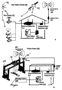
[0039] Reference is now made to FIGS. IA and 1B. FIGS. IA and lB are schematic
diagrams showing example base-station systems 100 and vehicle-mounted systems
200
suitable for use in implementing aspects of the invention.
[0040] In the embodiment shown in FIG 1A, a base station system 100 includes
one or
more receiver base stations 105, each comprising one or more satellite-based
position
signal receivers (e.g., GPS or other GNSS receivers) adapted to receive from
one or more
transmitters 99 (e.g., satellites or other signal sources) signals useful in
determining the
geographic or other position(s) of the base station receiver station(s) 105.
Each base
station 105 is stationary, or relatively stationary, or otherwise located in a
relatively
accurately-knowable position, and may be placed so as to serve as a reference
point in
providing correctional or confirmational data for vehicle or rover systems
operating
nearby. Any known location of any type compatible with the purposes described
herein,
including for example specially-placed or -constructed structures, or any
known
geographic location with a suitably-accurately placed mobile receiver, will
serve.
[0041] Satellite-based or other sensor signals received by base station(s) 105
may be
provided (e.g., via wired or wireless communications means) by a respective
sensor to
one or more signal receiver(s)/transmitter(s) 115 (e.g., one or more internet
routers)
associated with a base station server 110. Base station server(s) 110 (and
receiver(s) 115)
may be powered by one or more power supplies 125, which in various
applications are
preferably uninterruptible. Base station system(s) 100 may transmit/receive
data via
communication subsystem(s) 120 (e.g., an Internet access point). For example,
a base
station system 100 can receive satellite-based data signals from one or more
signal
sources 99 such as satellites.
CA 02746839 2011-07-19
-11-
[0042] The received signals can be processed by the base station server 110 to
interpret
them as providing information on a nominal, or signaled, position of the base
station.
Such nominal or signaled position may be compared, e.g., by the base station
server 110,
to a determined actual or defined position of the base station 105 (for
example, its
otherwise known actual geographic position, as opposed to a more- or less-
erroneously
determined position based on received raw signals); and any corresponding
positional
errors may be determined based on a detection of anomalous range measurements
from
the satellites. The determined error(s) may be used to generate corrected or
corrective
signals, and used in generation of control signals to be transmitted to
vehicle(s) 200.
[0043] Satellite-based data and/or other base station information may be
transmitted by
the base station system 100 to one or more vehicle-mounted or rover systems
200 via
communications subsystem 120 and may, for that purpose, include or employ one
or
more antennas 130 (e.g., omni-directional antenna(s)) and auxiliary components
such as
optional lightning arrestor(s) 135, and/or other desired or required
components for
suitably secure transmission/reception of data signals.
[0044] In the embodiment shown in FIG I B, a vehicle or "rover" system 200
comprises
one or more position data receivers 205 (e.g., GPS or other GNSS receivers)
mounted on
or otherwise associated with a vehicle 250 to be wholly or partially
automatically
navigated. Preferably, receivers 205 are provided in fixed or otherwise-
defined
relationship(s) to vehicle(s) 250. In some embodiments it can be advantageous
to provide
a vehicle system 200 with two or more sensors 205, for example to help improve
system
reliability, although in various embodiments this is not necessary.
[0045] Data representing, or otherwise useful in determining, the position of
vehicle
sensor(s) 205, and therefore corresponding to or otherwise useful in
determining the
position of vehicle 250, may be received by sensor(s) 205 from one or more
satellites or
other signal sources 99, and provided by the sensor(s) 205 to one or more
receiver(s)/transmitter(s) 215 of vehicle client system(s) 210 for processing
as disclosed
herein.
CA 02746839 2011-07-19
-12-
[0046] Vehicle system(s) 200 may comprise or communicate with one or more
navigation controllers, or control devices, 240 such as, for example, one or
more steering
controllers or steering systems, to facilitate generation and/or other
processing of signals
representing steering and/or other navigation control commands.
[0047] Vehicle system(s) 200 may transmit/receive data signals via one or more
communication subsystem(s) 220 (e.g., one or more Internet access point(s)),
which may
for example include one or more antennas 230 (e.g., one or more omni-
directional
antenna(s)) and/or auxiliary components, such as lightning arrestor 235, to
facilitate
transmission/reception of data.
[0048] Although a single vehicle 250 and rover system 200 are shown, systems
in
accordance with the invention may include multiple vehicles 250 and/or vehicle
systems
200, for use in navigating multiple vehicles. Embodiments of the invention
comprising
pluralities of vehicles 250 may provide one or more vehicle systems 200 for
each
controlled vehicle 250. For example, a single vehicle 250 may comprise
multiple
redundant systems 200, in order to ensure reliability and/or accuracy of
navigation. In
other examples, where there is a plurality of vehicles, a single vehicle
client may process
information from and provide steering or other navigation control for a
plurality of
vehicles.
[0049] FIG. 2 is a schematic diagram illustrating example signal processing
operations
executed by, for example, a base station system 100 in implementing aspects of
the
invention. Each of one or more base station(s) 105 communicates, wirelessly or
otherwise, position signals received from one or more signal sources 99 (FIGS.
1A and
IB) to base station server(s) 110, for example through a wired or wireless
local area
network (LAN or WLAN) 310. Such position signals may include, for example,
satellite
code and carrier phase data and satellite orbital (or "ephemeris")
information. The base
station(s) 105 may also receive signals (e.g., from the base station server
110) which
may for example provide information such as pre-determined base station
position data,
receiver/antenna types, satellite observation types, data update rates, and
data
communications information.
CA 02746839 2011-07-19
-13-
[0050] Base station server(s) 110 may include processor(s) (not shown) for
carrying out,
recording, and/or otherwise implementing positioning and/or other navigational
processes
as described herein. Base station server(s) 110 may further include
memory(ies) (not
shown) for storing data such as pre-defined navigation paths, known or
estimated base
station locations, and/or other position / navigational data. Base station
server(s) 110 may
exchange signals with other components of system(s) 100, 200 through any one
or more
communication subsystems 115, 120 that may receive signals from and transmit
signals
to the base station(s) 105 and/or vehicle system(s) 200 (e.g., through a LAN
or WLAN
310). Base station server(s) 110 may receive through communications
subsystem(s) 115,
120 signals representing, for example, raw satellite-based range (or
positioning) and
ephemeris data from the base station(s) 105, and dynamic navigation solutions,
and/or
other data relating to the vehicle system(s) 200, such as the operational
status of the
vehicle system(s) 200, from vehicle system(s) 200. Base station server(s) 110
may
transmit signals representing pre-determined coordinate locations of the base
station(s)
105; satellite receiver and antenna information; navigational information such
as data
related to pre-defined paths for the vehicle(s) 250 to travel; and any other
desired or
required information.
[0051] Base station system(s) 100 may transmit to controlled or otherwise
associated
vehicle system(s) 200 signals representing, for example, satellite-based raw
measurements from the base station(s) 105, satellite ephemeris information
from the base
station(s) 105, pre-determined coordinates of the base station(s) 105, data
information
about the receiver(s) and antenna(es); and/or information relating to pre-
defined paths
and/or other navigational data useful in steering or otherwise directing the
corresponding
vehicle(s) 250. Base station system(s) 100 may also receive signals from the
vehicle
system(s) 200 representing, for example, data or solutions useful in
navigating or
monitoring the corresponding vehicle(s) 250, including for example data or
solutions
relating to current or desired linear or rotational position(s), velocity(ies)
and/or
acceleration(s).
[0052] FIG. 3 is a schematic diagram illustrating example signal processing
operations of
a vehicle-mounted system 200 for a vehicle 250 in accordance with the
invention. In the
CA 02746839 2011-07-19
-14-
example shown, a vehicle 250 is provided with one or more GNSS or other
position
sensors 205. Vehicle system 200 will be described mainly with reference to
only one
sensor 205 provided for the vehicle. In some examples, where multiple sensors
205 are
used, the use of multiple sensors 205 may allow for cross-checking of
solutions and/or
data among sensors 205. For example, the data and/or solutions derived from
the sensors
205 may be verified to agree with each other within one or more pre-determined
thresholds.
[0053] Vehicle (or "rover") sensor(s) 205 may communicate with vehicle client
systems
210, 240, etc., using WLANs and/or LANs as previously discussed. Vehicle
sensor(s)
205 may transmit/receive signals representing, for example, raw satellite-
based data (e.g.,
code and carrier phase information) and/or other satellite-related signals, as
desired.
Sensor(s) 205 may receive control and other signals from the vehicle client
210 and/or,
for example, via WLAN or LAN 310, base station server(s) 110, etc.
[0054] A vehicle client system 210 may include processor(s), memory(ies), and
other
components useful in generating, executing or acting upon, and otherwise
processing
automatic steering and other navigational control commands for use by vehicle
navigation system(s) or control device(s) 240 and/or for processing by base
station
server(s) 110, as described herein. Vehicle client memory(ies) may be used to
store,
among other records, calculated position data and/or pre-defined paths for the
vehicle.
Control signals generated or otherwise processed by vehicle client 210 and/or
other
components of systems 100, 200, etc., may be communicated to navigation
system(s) or
control device(s) 240 via, for example, a controller area network (CAN) 320.
[0055] A vehicle client 210 (and/or any one or more base station server(s) 110
or other
data processors) may carry out either or both of synchronous and asynchronous
processing of satellite-based data in order to optimize and/or otherwise
implement
navigation processes for vehicle(s) 250. For example, a vehicle client 210 may
process
such data as a part of calculating dynamic solutions (e.g., position, velocity
and
acceleration) for the vehicle.
CA 02746839 2011-07-19
-15-
[0056] The vehicle client 210 may also calculate or otherwise process fuzzy
logic or
control feedback input values, for example heading error, track offset and
curvature
values, which may be used in one or more fuzzy logic or control feedback
algorithms for
generating steering commands. For example, using fuzzy control parameters
(e.g.,
input/output functions) determined in an optimization process, fuzzy output
values (e.g.,
steering angle and speed) may be estimated. Vehicle client(s) 210 may also
provide
control commands to the sensor 205 on the vehicle.
[0057] Automatic steering and/or other navigation commands, which may include,
for
example, steering angle and speed commands (e.g., as determined by the vehicle
client
210) may be transmitted to the navigational system(s) 240. Navigational
system(s) 240
may transmit status and/or other feedback data (for example, wheel angles,
pedal actions
and joystick actions) to be processed by the vehicle client 210 and/or other
components
of system(s) 100, 200, etc.
[0058] FIG. 4 is a schematic diagram illustrating aspects of an example
process for
generating automatic steering and/or other navigational control command
signals in
accordance with the invention. Such processes may be carried out by vehicle
client
system(s) 210 and/or other processors, in stand-alone or distributed data
processing
schemes. As will be understood by those skilled in the relevant arts, in many
circumstances it can be advantageous to have all or various portions of such
processes
performed on board a vehicle 250, or otherwise in close proximity to rover
station(s) 205
and/or navigational system(s) 240, in order to minimize data processing and
navigation-
system response times, and/or otherwise optimize control of the vehicle(s)
250.
[0059] In various embodiments the blocks shown in FIG. 4 and the other figures
described herein can be interpreted as any of a wide variety of programming
blocks or
modules, engines, routines, applications, or software layers or other
programming
structures, and/or combinations thereof, adapted to interact with and support
each other in
implementing various processing tasks related to fully- or partially automatic
navigation
of vehicle(s) 250. As will be understood by those skilled in the relevant
arts, a wide
CA 02746839 2011-07-19
-16-
variety of such structures, now known and doubtless hereafter to be developed,
are and
will be suitable for use in implementing the invention.
[0060] Data interface surface(s) or layer(s) 410 may be used for interfacing
or otherwise
facilitating data communications between any one or more of base station
server(s) 110,
vehicle sensor(s) 205, and database(s) 330 storing pre-defined paths and/or
other data
useful in navigating the vehicle(s) 250. A data interface surface 410 can, for
example, be
implemented as a part of, or otherwise in association with, vehicle client(s)
210. For
example, data interface surface(s) 410 can advantageously be implemented as
component(s) of communication subsystem(s) 220.
[0061] Data used by system(s) 210, 110, etc. in generating and/or otherwise
implementing navigational control signals may be processed synchronously
(i.e., where
up-to-date base station satellite-based information is available but is
processed separately
from vehicle satellite-based information, such as when base station
information is
temporally delayed or otherwise cannot be processed efficiently in real time)
or
asynchronously (i.e., where up-to-date vehicle satellite-based information is
available and
is processed in real time, and older base station satellite-based information
is used).
[0062] Using synchronous data processing processes starting for example at
420, raw
satellite data or satellite-based data provided by base station(s) 105 and/or
one or more
vehicle sensor(s) 205 may be used to resolve ambiguities in satellite carrier-
phase data.
Satellite carrier-phase ambiguity represents an arbitrary counter setting
(typically an
integer value) of the carrier-phase tracking register at the start of data
from a satellite
(i.e., phase lock), which biases all measurements in an unbroken sequence of
that
satellite's carrier-phase data. Once such ambiguities are determined and
accounted for,
the carrier-phase data may be used to determine high-precision (e.g., on the
order of
millimeters) range or position measurements, thus allowing for sub-centimeter
determination of position.
[0063] Ambiguity resolution processes, many of which are now known, may be
susceptible to biases and errors, for example ionospheric and tropospheric
delay, satellite
orbit error, satellite and/or receiver clock error, antenna phase centre
offset and/or
CA 02746839 2011-07-19
-17-
variation, instrumental group delay, phase wind-up, and multipath. Some or all
of such
error sources may be substantially removed or reduced using relative
positioning. For
example, by differencing satellite-based observations between the base station
system
100 and the vehicle system 200 and/or between satellites 99 (e.g., using a
double-
differencing method), common error sources may be substantially removed or
reduced. In
general, ambiguities in satellite-based data may be relatively constant or
stable over time
unless cycle-slip occurs, and thus may be relatively unaffected by time
latency.
Correction factors for such errors may be determined, if necessary, by the
vehicle or
rover system(s) 200 and applied, directly or indirectly, by vehicle client(s)
210 to vehicle
positions calculated by the client(s) 210 using data provided by vehicle
sensor(s) 205.
[0064] The use of such ambiguity resolution processes has been found to
substantially
improve the accuracy, precision, reliability and safety of applications such
as the
automatic control (of which autosteering is one type) of RTG cranes in, for
example
container loading and unloading. Details of methodologies suitable for use in
resolving
carrier phase ambiguities in implementing processes according to this aspect
of the
disclosure are provided, for example, in Teunissen and Kleusberg (eds.), GPS
for
Geodesy, published by Springer-Verlag, Berlin, 1996 and 1998 (particularly pp.
321 -
336); and in H. Abidin, On-the-Fly Ambiguity Resolution, GPS World, April
1994, pp.
40 - 49.
[0065] Parameters used in, generated as a part of, or otherwise related to
ambiguity
resolution processes at 420 etc., can be stored, for example in memory
accessible by
vehicle client(s) 210, for use in asynchronous data processing. Asynchronous
processing,
in this context, includes processing performed by client system(s) 210 using
position data
generated and/or received directly onboard vehicle 250 through, for example
receivers/sensors 205.
[0066] The use of one or more asynchronous processes performed by client
system(s)
210 may be particularly advantageous where, for example, latencies in
communications
and/or other issues cause satellite-based data or position data received from
base
station(s) 100 to be processable at a relatively slower rate compared to data
generated or
CA 02746839 2011-07-19
-18-
otherwise available on board vehicle system(s) 210. For example, where a
vehicle 250 is
moving or otherwise changing its navigational status - e.g., position,
velocity,
acceleration, attitude, or orientation - at a rate that makes it unwise or
otherwise
undesirable to make each control signal output of either or both of
controller(s) 210, 240
dependent upon a confirmed or corrected positional fix using data received
from base
station(s) 100, one or more asynchronous processes can be performed on board
the
vehicle(s) 250 to improve stability and control of the vehicles.
[0067] In the example provided in Figure 4, two asynchronous processing modes
may be
employed: asynchronous data processing 430 at moderate, or relatively slower,
data rates
(e.g., 10-20 Hz) and relatively fast asynchronous data processing 440 at
relatively fast
data rates (e.g., greater than 20 Hz, such as 100 Hz). Fast asynchronous data
processing
440 may include simplified calculations or may omit certain calculations,
which may be
useful to lessen the computing load or to accommodate limited computing
resources in
while providing critical control for unstable or otherwise highly sensitive
control
parameters. For example, while asynchronous data processing 430 at moderate
rates may
determine translational navigation solution(s) (e.g., to determine and control
position,
linear velocity and acceleration of the vehicle) as well as orientation, the
fast
asynchronous data processing 440 may be used to generate signals for control
of
relatively critical and/or unstable parameters such as vehicle rotational or
attitude
orientation.
[0068] Data generated using synchronous and/or asynchronous processes 420,
430, 440
may be used directly in generating translational and orientation commands, or
may be
subjected to further processes first. For example, in order to improve the
accuracy,
reliability, efficiency, etc., of such commands, further control logic, such
as for example
fuzzy logic controller process 450 and/or various forms of control feedback
loops may be
employed.
[0069] In various embodiments, a particularly suitable form of control
feedback
processing has been found to be PID processing. A PID controller typically
calculates an
"error" value as the difference between a measured process variable and a
desired
CA 02746839 2011-07-19
-19-
setpoint, and attempts to minimize the error by adjusting control inputs. A
PID controller
algorithm involves three separate constant parameters: proportional, integral,
and
derivative values, which can be interpreted in terms of time: P depends on the
present
error, Ion the accumulation of past errors, and D is a prediction of future
errors, based on
current rate of change. A weighted sum of these three values may be used to
adjust the
controlled process via a control element such as the output of an autosteering
or other
automatic navigation control device.
[0070] A description of methodologies suitable for use in applying fuzzy logic
and
control feedback processes, including PID feedback processing, to control
processes in
accordance with the disclosure provided in J. Jantzen, Design of Fuzzy
Controllers,
Technical University of Denmark (1998).
[0071] Generated translational and/or orientation commands may be transmitted
to the
vehicle's steering or other navigation system 240, for example via a CAN
interface, for
implementation using suitably-configured control interfaces.
[0072] Automatic steering or other navigational control apparatus may be used
to steer,
spatially orient, or otherwise cause the vehicle to follow a pre-determined or
other desired
path, or assume a desired orientation with respect to a desired reference.
[0073] The use of stored pre-determined paths may allow vehicle(s) 250 to
automatically
steer desired courses or otherwise travel to desired locations, optionally at
desired speeds
and in accordance with desired vehicle orientations. Pre-defined paths may be
provided
in a navigational database 330 (see, e.g., FIG. 5), for example by driving the
vehicle (e.g.,
by a human operator) over the path and recording the path by periodically
storing
observed position and/or attitude data (derived, for example, using signals
from either or
both of base station and vehicle systems 100, 200, and/or other position /
attitude sensors)
in a suitably-configured navigational database 330 (see, e.g., FIG. 5). The
pre-defined
path may be recorded and stored with satellite-based positioning data for
later access by,
for example, a vehicle controller 210, so that the vehicle controller 210 can
autonomously
reproduce the mapped path by comparing observed current position(s) and/or
attitude(s)
to recorded, desired (or otherwise commanded) position(s) and/or attitude(s)
and
CA 02746839 2011-07-19
-20-
generating suitable command signals for steering, throttle, and/or other
navigation
system(s) 240. Multiple paths can be mapped and each path may be associated
with a
particular site or location, for example using the satellite-based coordinates
within the
path. Pre-defined navigation paths may be stored, for example, locally in
memory(ies)
accessible by or otherwise associated with vehicle client(s) 210, downloaded
to separate
storage (e.g., removable USB flash memory drives) and/or uploaded from
memory(ies) of
base station server(s) 110.
[0074] For example, where the vehicle 250 is an RTG crane, the RTG crane may
be
moved to an operations site (e.g., a plot of a container yard). The operations
site may be
selected (e.g., by a human operator) from a corresponding, pre-stored list,
and a desired
navigation path may be matched or selected from a list of paths saved for the
site. Such a
path can be selected from a path database 330 stored in the vehicle client 210
memory
and/or downloaded from the base station server 110. The vehicle client 210 may
also
(e.g., at substantially the same time) send its position to the base station
server 110. Upon
receiving the RTG crane's position, the base station server 110 may establish
a
communication connection between the vehicle client 210 and one or more base
stations
105 (e.g., the nearest base station) for reception of real-time satellite-
based data stream
from the base station(s) 105.
[0075] Once a pre-defined path has been selected or downloaded, the RTG crane
can be
positioned at or near the start of the pre-defined navigation path and
automatic steering
can be activated. A delay may be provided before automatic navigation
commences (e.g.,
sufficient to allow the operator to clear the RTG crane). The RTG crane may
begin
automatic steering along the pre-defined navigation path (e.g., to move to the
selected
container or location).
[0076] Among the many advantages offered by the invention, in its various
aspects, are
improved control and/or verification of vehicle position. Processes according
to the
invention may, for example, be useful for determining, or confirming, the
position of a
vehicle 250 on the surface of the earth within the order of a few centimetres,
even while
the vehicle is in motion. Under purely non-referenced, robotic control (i.e.,
without
CA 02746839 2011-07-19
-21-
satellite-based or other location sensor guidance in accordance with the
invention), a
vehicle may wander off course, for example due to errors caused by wheel
slippage,
uneven terrain, and other mechanically-induced errors, and/or navigation or
data
processing errors; and such errors may grow as a non-linear product of time.
Systems and
methods in accordance with the invention may use satellite-based RTK
navigation
solutions and attitude information to correct the errors in the steering
system 240 so that
the vehicle tracks the pre-defined navigation path to within acceptable
accuracy of the
satellite-based RTK solutions (e.g., to within a few centimetres).
[0077] FIG. 5 is a schematic diagram illustrating aspects of synchronous data
processing
operations 420 in accordance with various embodiments of the invention. A
process 420
may be carried out by, for example, vehicle client system(s) 210, and may be
implemented using single or multiple vehicle sensors 205. A primary use of a
synchronous process 420 may be in resolving carrier-phase ambiguities in the
satellite-
based data. The result(s) of such process 420 may further be used in other
processes to
estimate or confirm current vehicle position, either directly using satellite-
based data or
using dead reckoning or other processes to extrapolate from a last known fixed
position.
[0078] A process 420 may synchronize raw data from known position information,
base
station sensor(s) 105 and/or vehicle sensor(s) 205 to resolve any ambiguities
(e.g., integer
ambiguities) in satellite-based carrier-phase observations, using base
station(s) 100 and/or
base station sensor(s) 105 to define relatively stationary or otherwise well-
known
reference point(s) for a vehicle 250 in relative proximity to the base
station(s), which may
be provided to vehicle client system(s) 210 for use in estimating vehicle
positions by the
client system(s) 210 in order to increase confidence in the actual location(s)
of the
corresponding vehicle(s). In general, in the process 420, satellite-based data
(e.g.,
obtained by the base station's sensor(s) 105) may be sent from the base
station system
100 to the vehicle system 200 to be synchronized with the vehicle's satellite-
based data
(e.g., obtained by the vehicle's sensor(s) 205). The known position of the
base station 100
may be used to process data from both the base station sensor(s) 105 and the
vehicle
sensor(s) 205 to estimate the position of the vehicle. Such processing may
include
CA 02746839 2011-07-19
-22-
ambiguity resolution. Such processing may also include differential processing
(e.g.,
subtracting vehicle data from base station data) to remove or reduce common
errors.
[0079] As will be understood by those skilled in the relevant arts, once they
have been
made familiar with this disclosure, the use of reference points in relatively
close
proximity to vehicles 250 can help to minimize error in, i.e., increase the
accuracy of,
vehicle position and orientation determinations in accordance with the
disclosure.
[0080] A vehicle client 210 may receive position information from a base
server 110,
including, for example, raw satellite-based measurements (e.g., code and
carrier phase
information), satellite ephemeris information, and base coordinates and
receiver/antenna
information from each base station 105. The vehicle client 210 may also
receive
information from a path database 330, for example a three-dimensional (3D)
digital map
of the pre-defined path. The vehicle client 210 may also receive information
from the
vehicle sensor(s) 205 (e.g., code and carrier phase information).
[0081] Vehicle satellite-based raw measurements, base station satellite
ephemeris
information and base coordinates may be used in a point positioning (PP)
filter 460 in
order to determine the orbit position, velocity and acceleration of the
satellites from
which the raw measurements were obtained, and/or the approximate position,
velocity
and acceleration of the vehicle 250. In the matching portion of a map and
match
programming processes, such navigation information may be used to initialize
and may
help to expedite the search process (i.e., map matching) in the path database
330.
[0082] Vehicle raw measurements may also be used in a digital differentiator
470, to
determine Doppler shift and change of Doppler shift. The Doppler shift value
and
change of Doppler shift value may be used, in addition to the velocity and
acceleration
values derived from the satellite-based data, for estimating the vehicle
velocities and
accelerations.
[0083] Data representing vehicle satellite-based raw measurements, the digital
differentiator 470 and the base station satellite-based raw measurements may
be used in a
single differencing (SD) filter 480. The SD filter 480 may be useful for
filtering out
CA 02746839 2011-07-19
-23-
common errors between a pair of satellites 99 (e.g., satellite clock errors,
satellite orbit
errors, satellite antenna phase centre offset, satellite instrumental group
delay, satellite
phase wind-up, and errors due to ionospheric and/or tropospheric delay) or
between a pair
of satellite receivers or sensors 105, 205 (e.g., satellite receiver clock
error, receiver
antenna phase centre offset, receiver instrumental group delay, and receiver
phase wind-
up).
[0084] Results from the SD filter 480 may be further processed using a double
differencing (DD) filter 490. The DD filter 490 may be useful for filtering
out common
errors (e.g., similar to those described with respect to the SD filter 480)
between a pair of
satellite receivers and a pair of satellites.
[0085] Although not shown, in further embodiments triple differencing (TD)
filters may
be used. Results from the DD filter 490 may be further processed using the TD
filter,
which may be useful for filtering out sudden large errors, such as sudden
jumps in the
carrier-phase observations (e.g., cycle slips due to a loss of signal phase
lock in the base
station sensor(s) 105 and/or the vehicle sensor(s) 205).
[0086] Filtered sensor data from an SD filter 480 may also be used to
calculate the
rotation or orientation of the vehicle sensor 205. The rotation or orientation
of the vehicle
sensor 205 may be used to determine the heading (i.e., predicted direction or
other
angular attitude) of the vehicle 250, e.g., as a redundancy check. Such
determinations
may be based on detection of orientation by the sensor 205 using, for example,
polarization detectors. In some examples, rotation may be sensed by a single
sensor 205
on the vehicle, however in other examples, two or more sensors 205 on the
vehicle may
be used for determining orientation of the vehicle.
[0087] Results from the DD filter 490 may be used to calculate velocity and
acceleration
of the vehicle sensor 205. The velocity and acceleration of the vehicle sensor
205 may be
used to determine the heading (i.e., predicted direction) of the vehicle.
CA 02746839 2011-07-19
-24-
[0088] Data from the DD filter 490, PP filter 460, sensor rotation and the pre-
defined
path may be used in an ambiguity search engine 800, in order to determine the
vehicle
position and/or ambiguity parameters.
[0089] Vehicle heading (e.g., including redundant solutions), vehicle position
and
ambiguity parameters may be used as input to a synchronous navigation solution
filter
482 to generate position data for use in generating control commands and as
input to
asynchronous processes as described herein. The results of the process 420 may
be used
as a navigation solution filter, to help improve reliability of further
asynchronous
processes, for example as described below.
[0090] FIG. 6 schematically illustrates an example process 430 for
asynchronous data
processing in accordance with aspects of the invention. In the embodiment
shown,
process 430 is generally similar to process 420 of FIG. 5, except that it
includes use of
ambiguity parameters determined using data provided by base station system(s)
100 in
accordance with, for example, synchronous processing techniques such as
process 420.
[0091] A process 430 such as that shown in FIG. 6 may be implemented at
relatively
moderate rates (e.g., approximately 10 Hz in some embodiments) suitable for
use in
guiding a vehicle 250, but faster than the synchronous processing rate (e.g.,
approximately 1 Hz, in some embodiments) used for data received from base
station
server(s) 110 for, e.g., determining position fixes for the location of a
vehicle 250).
[0092] A process 430 such as that shown in FIG. 6 may be useful for, for
example,
determining estimated vehicle positions, velocities, accelerations, and
attitudes (e.g.,
headings) in a substantially real-time manner, using old or previously
determined
information from synchronous processes such as process 420 of FIG. 5. The
example
process 430 may process satellite-based raw measurements from the base
station(s) 105
and the vehicle in an asynchronous manner, at the vehicle's data rate (e.g.,
10-20 Hz), for
example calculated ambiguity parameters previously processed according to the
synchronous data processing described above.
CA 02746839 2011-07-19
-25-
[0093] Vehicle client system(s) 210 may receive information from corresponding
base
station server(s) 110, including, for example, raw satellite-based
measurements (e.g.,
code and carrier phase information), satellite ephemeris information, and base
coordinates and receiver/antenna information from each base station(s) 105.
Information
from the base station server(s) 110 may include asynchronously-determined
information
(i.e., information extrapolated from old information, as opposed to real-time
or current
information) to accommodate a base station server 110's slower data processing
rate, for
example. A vehicle client system 210 may also access or otherwise receive
information
from a path database 330, for example a two- or three-dimensional (2D or 3D)
digital
map of the pre-defined path. The vehicle client 210 may also receive
information from
vehicle sensor(s) 205 (e.g., code and carrier phase information). The vehicle
client 210
may also access or otherwise receive or have stored (e.g., in the vehicle
client's memory)
ambiguity parameters that have been resolved and any additional correction
factors
calculated according to the synchronous data processing described above.
[0094] The vehicle satellite-based raw measurements, base station satellite
ephemeris
information and base coordinates may be used in a point positioning (PP)
filter 460. This
may use the orbit position, velocity and acceleration of satellites from which
position data
has been received in order to determine the approximate position, velocity and
acceleration of the vehicle. In the matching portion of map and match
programming, this
navigation information may be used to initialized and may help to expedite the
search
process (i.e., map matching) in the path database 330.
[0095] The vehicle raw measurements may also be used in a digital
differentiator 470, to
determine Doppler shift and change of Doppler shift. The Doppler shift value
and change
of Doppler shift value may be used, in addition to the velocity and
acceleration values
derived from the satellite-based data, for estimating the vehicle velocities
and
accelerations.
[0096] Data from the vehicle raw measurements, the digital differentiator 470
and the
base station raw measurements may be used, as in process 420, in conjunction
with single
differencing (SD), double differencing (DD), and/or triple differencing (TD)
filters filter
CA 02746839 2011-07-19
-26-
to eliminate common errors or sudden jumps in data from a pair of sensors 105,
205
and/or a pair of satellites 99.
[0097] Results from SD filter(s) 480 may be used to calculate the rotation or
orientation
of the vehicle sensor 205. The rotation or orientation of a vehicle sensor 205
may be used
to determine the heading (i.e., predicted direction) of the vehicle, e.g., as
a redundancy
check.
[0098] Results from DD filter(s) 490 may be used to calculate velocity,
acceleration
and/or rotation or orientation of vehicle sensor(s) 205. The velocity and
acceleration of
vehicle sensor(s) 205 may be used to determine the heading (i.e., predicted
direction) of
the vehicle(s). The relative rotation or orientation of vehicle sensor(s) 205
may be used
to determine the heading (i.e., predicted direction) of the vehicle(s), e.g.,
as a redundancy
check.
[0099] Data from DD filter(s) 490 and from PP filter(s) 460; vehicle rotation
data; pre-
defined path data; and/or previously-calculated ambiguity parameters (e.g.,
from
synchronous data processing 420) may be used as input to ambiguity-free
position
estimator 500 to determine vehicle position. An ambiguity-free position
estimator 500
may implement any position estimator processes suitable for the purposes
disclosed
herein.
[00100] Vehicle heading (e.g., including redundant solutions) and vehicle
position
information may be used as input to an asynchronous navigation solution filter
486.
[00101] Output from asynchronous navigation solution filter 486 may be further
used (e.g., in a fuzzy logic controller 450) to generate control commands for
automatic
control of the vehicle's steering, and such control commands may be
transmitted to the
steering system 240 for the vehicle.
[00102] FIG. 7 schematically illustrates an example process 440 for fast (or
relatively faster) asynchronous data processing in accordance with aspects of
the
invention. In the example shown, fast asynchronous data process 440 may be
implemented at a relatively fast rate suitable for the vehicle client 210 but
faster than the
CA 02746839 2011-07-19
-27-
data processing rate for the base station server 110 (e.g., substantially
faster than 1 Hz).
Calculations in this example process may be simplified compared to the example
asynchronous data processing 430 described above, for example in order to
lessen
computing power and accommodate the faster rate.
[00103] Relatively faster asynchronous processes such as that shown in FIG. 7
may, for example, be used advantageously to monitor and/or control navigation
processes
that are particularly sensitive to stability or other control issues, such
that any problematic
instabilities may be prevented before they exceed a predefined tolerance
threshold.
[00104] In the example shown, process 440 may process satellite-based raw
measurements from the base station(s) 105 and the vehicle sensor(s) 205 at a
rate (e.g.,
above 20 Hz) higher than that implemented by either synchronous process 420 or
relatively slow asynchronous process 430. Calculation of dynamic information
about the
satellite and the vehicle, and calculation of ambiguity-free vehicle position
may be
omitted to simplify data processing, in order to accommodate a required or
desired higher
control sampling and command generation rate.
[00105] A vehicle client 210 may receive information from base station
server(s)
110, including, for example, satellite-based raw measurements (e.g., code and
carrier
phase information). Information provided by base station server(s) 110 may
include out-
of-date or latent information (i.e., old information as opposed to real-time,
current
information) to accommodate continuous control input, in spite of relatively
slow base
station server processing rates by, for example, extrapolating from last-known
synchronously-derived data. The vehicle client 210 may also receive
information from a
path database 330, for example a three-dimensional (3D) digital map of the pre-
defined
path and previously-calculated ambiguity parameters (e.g., from synchronous
data
processing 420). The vehicle client 210 may also receive information from the
vehicle
sensor(s) 205 (e.g., code and carrier phase information), and from relatively
slower
asynchronous processes 420.
[00106] As in the case of previously-described synchronous and asynchronous
processes 420, 430, SD, DD, and TD filters may be applied.
CA 02746839 2011-07-19
-28-
[00107] Results from SD filter(s) 480 may be used to calculate particularly
sensitive or critical rotational or orientation information for vehicle
sensor(s) 205. Results
from SD filter(s) 480 may also be used as input by DD filter(s) 490. Results
generated by
DD filter(s) 490 may also be used to calculate rotational or orientation
information for the
vehicle sensor 205. The rotation or orientation of vehicle sensor(s) 205 may
be used to
determine the heading (i.e., predicted current direction of travel) of a
vehicle.
[00108] Satellite-based sensor rotation and pre-defined path data may be used
in
generating control command signals using a fast asynchronous navigation
solution filter
488. Such commands can be used, for example, to control rotational or
particularly
unstable navigational parameters. Results of processes may be further used
(e.g., in a
fuzzy logic controller 450) to determine control commands for automatic
control of the
vehicle's steering, and such control commands may be transmitted to the
steering system
240 for the vehicle.
[00109] Any suitable ambiguity resolution process may be implemented by, for
example, an ambiguity search engine or application 800, and executed in
conjunction
with, or as a part of, a synchronous data process 420 of FIG. 5. A suitable
ambiguity
resolution process may for example be implemented as a module or application
executed
by a base station server system 110 and/or a vehicle client system 210. For
example, an
ambiguity resolution process may resolve integer ambiguities using
calculations based on
satellite carrier phase information. The calculated ambiguity resolution may
be used as
input to a synchronous navigation solution filter 482 and the results used in
further
processing, for example by the fuzzy logic controller 450, to determine and
generate
steering and/or other navigational control commands.
[00110] Any suitable satellite-based rotation determination process may be
used in
combination with, for example, the example data processes of FIGS. 5, 6 and 7.
Such
rotation determination processes may, for example, be useful for determining
the
orientation of a vehicle 250 having only a single sensor 205. Such processes
may further,
for example, be implemented as a module or application to be executed, for
example by
vehicle client system(s) 210. The results of the rotation determination
process may be
CA 02746839 2011-07-19
-29-
used as input to a synchronous navigation solution filter 482 and/or an
asynchronous
navigation solution filter 486 and the results used in further processing, for
example by
the fuzzy logic controller 450, to determine and generate steering and/or
other
navigational control commands.
[00111] Any suitable fuzzy logic signal processing operation 450 may be used
in
implementing aspects of the invention. The process may be suitable for
execution by, for
example, vehicle client system(s) 210 as a part of, or in conjunction with,
process(es)
such as that shown in FIG. 4.
[00112] The fuzzy logic controller 450 may receive or otherwise access data
defining or otherwise related to a pre-defined or otherwise-desired path
(e.g., in the form
of a 3D digital map) from the path database 330, which may be stored at the
base station
system 100, stored at the vehicle system 200 or otherwise accessible by the
vehicle client
210. Such example process may also receive fuzzy logic controller (FLC)
input/output
optimization parameters, for example from a FLC optimization component, which
may
reside in the base station system 100, the vehicle system 200 or otherwise
accessible by
the vehicle client 210. In some examples, the process may be carried out off-
line or may
be carried out on-line, for example where computer resources are sufficient.
[00113] The FLC process may receive as input determined navigation solutions
(e.g., from process 430 or process 440) and may generate as output calculated
steering
and/or other navigational control commands (e.g., steering angle and speed
commands).
[00114] While the present disclosure refers to use of synchronous,
asynchronous
and fast asynchronous data processing, at various data processing rates, it
should be
understood that one or some of such processes may be omitted, and that
processing rates
may vary over a very wide range of cycle speeds. For example, asynchronous
data
processing may not be necessary where the base station server data processing
rate is as
fast as or faster than the vehicle client data processing rate. In another
example, fast
asynchronous data processing may not be necessary where the vehicle client has
sufficient computing power to carry out asynchronous data processing at
relatively fast
CA 02746839 2011-07-19
-30-
rates even without simplifying calculations, for example, to control a high-
speed or
potentially unstable vehicle 250.
[00115] Although certain calculations and algorithms have been described, it
should be understood that the present disclosure is not in all cases limited
to such
calculations or algorithms, and variations may be possible.
[00116] The embodiments of the present disclosure described above are intended
to be examples only. Alterations, modifications and variations to the
disclosure may be
made without departing from the intended scope of the present disclosure. In
particular,
selected features from one or more of the above-described embodiments may be
combined to create alternative embodiments not explicitly described. All
values and sub-
ranges within disclosed ranges are also disclosed. The subject matter
described herein
intends to cover and embrace all suitable changes in technology. All
references
mentioned are hereby incorporated by reference in their entirety.
[00117] Many variations and modifications of the systems, methods, and
programming products described herein may be made without departing from the
spirit
and scope of the invention(s) disclosed herein. The disclosure and
invention(s) are
therefore not to be limited to the exact components or details of methodology
or
construction set forth above. Except to the extent necessary or inherent in
the processes
themselves, no particular order to steps or stages of methods or processes
described in
this disclosure, including the Figures, is intended or implied. In many cases
the order of
process steps may be varied without changing the purpose, effect, or import of
the
methods described. The scope of the invention is to be defined solely by the
appended
claims, giving due consideration to the doctrine of equivalents and related
doctrines.
Examples of processing rates described are only for the purpose of
illustration and are not
intended to be limiting.