Note: Descriptions are shown in the official language in which they were submitted.
CA 02750908 2011-07-21
METHODS AND APPARATUS FOR DISPLAYING AND PROCESSING
FACILITIES MAP INFORMATION AND/OR OTHER IMAGE INFORMATION
ON A MARKING DEVICE
BACKGROUND
[0001] Field service operations may be any operation in which companies
dispatch
technicians and/or other staff to perform certain activities, for example,
installations,
services and/or repairs. Field service operations may exist in various
industries, examples
of which include, but are not limited to, network installations, utility
installations, security
systems, construction, medical equipment, heating, ventilating and air
conditioning
(HVAC) and the like.
[0002] An example of a field service operation in the construction
industry is a so-
called "locate and marking operation," also commonly referred to more simply
as a
"locate operation" (or sometimes merely as "a locate"). In a typical locate
operation, a
locate technician visits a work site in which there is a plan to disturb the
ground (e.g.,
excavate, dig one or more holes and/or trenches, bore, etc.) so as to
determine a presence
or an absence of one or more underground facilities (such as various types of
utility cables
and pipes) in a dig area to be excavated or disturbed at the work site. In
some instances, a
locate operation may be requested for a "design" project, in which there may
be no
immediate plan to excavate or otherwise disturb the ground, but nonetheless
information
about a presence or absence of one or more underground facilities at a work
site may be
valuable to inform a planning, permitting and/or engineering design phase of a
future
construction project.
[0003] In many states, an excavator who plans to disturb ground at a
work site is
required by law to notify any potentially affected underground facility owners
prior to
undertaking an excavation activity. Advanced notice of excavation activities
may be
provided by an excavator (or another party) by contacting a "one-call center."
One-call
centers typically are operated by a consortium of underground facility owners
for the
purposes of receiving excavation notices and in turn notifying facility owners
and/or their
agents of a plan to excavate. As part of an advanced notification, excavators
typically
provide to the one-call center various information relating to the planned
activity,
-1-
CA 02750908 2011-07-21
including a location (e.g., address) of the work site and a description of the
dig area to be
excavated or otherwise disturbed at the work site.
[0004] Figure 1 illustrates an example in which a locate operation is
initiated as a
result of an excavator 1 providing an excavation notice to a one-call center
2. An
excavation notice also is commonly referred to as a "locate request," and may
be provided
by the excavator to the one-call center via an electronic mail message,
information entry
via a website maintained by the one-call center, or a telephone conversation
between the
excavator and a technician at the one-call center. The locate request may
include an
address or some other location-related information describing the geographic
location of a
work site at which the excavation is to be performed, as well as a description
of the dig
area (e.g., a text description), such as its location relative to certain
landmarks and/or its
approximate dimensions, within which there is a plan to disturb the ground at
the work
site. One-call centers similarly may receive locate requests for design
projects (for which,
as discussed above, there may be no immediate plan to excavate or otherwise
disturb the
ground).
100051 Using the information provided in a locate request for planned
excavation or
design projects, the one-call center identifies certain underground facilities
that may be
present at the indicated work site. For this purpose, many one-call centers
typically
maintain a collection "polygon maps" which indicate, within a given geographic
area over
which the one-call center has jurisdiction, generally where underground
facilities may be
found relative to some geographic reference frame or coordinate system.
[0006] Polygon maps typically are provided to the one-call centers by
underground
facilities owners within the jurisdiction of the one call center ("members" of
the one-call
center). A one-call center first provides the facility owner/member with one
or more maps
(e.g., street or property maps) within the jurisdiction, on which are
superimposed some
type of grid or coordinate system employed by the one-call center as a
geographic frame
of reference. Using the maps provided by the one-call center, the respective
facilities
owners/members draw one or more polygons on each map to indicate an area
within
which their facilities generally are disposed underground (without indicating
the facilities
themselves). These polygons themselves do not precisely indicate geographic
locations of
respective underground facilities; rather, the area enclosed by a given
polygon generally
provides an over-inclusive indication of where a given facilities owner's
underground
-2-
CA 02750908 2011-07-21
facilities are disposed. Different facilities owners/members may draw polygons
of
different sizes around areas including their underground facilities, and in
some instances
such polygons can cover appreciably large geographic regions (e.g., an entire
subdivision
of a residential area), which may further obfuscate the actual/precise
location of respective
underground facilities.
[0007] Based on the polygon maps collected from the facilities
owners/members, the
one-call center may in some instances create composite polygon maps to show
polygons
of multiple different members on a single map. Whether using single member or
composite polygon maps, the one-call center examines the address or location
information
provided in the locate request and identifies a significant buffer zone around
an identified
work site so as to make an over-inclusive identification of facilities
owners/members that
may have underground facilities present (e.g., to err on the side of caution).
In particular,
based on this generally over-inclusive buffer zone around the identified work
site (and in
some instances significantly over-inclusive buffer zone), the one-call center
consults the
polygon maps to identify which member polygons intersect with all or a portion
of the
buffer zone so as to notify these underground facility owners/members and/or
their agents
of the proposed excavation or design project. Again, it should be appreciated
that the
buffer zones around an indicated work site utilized by one-call centers for
this purpose
typically embrace a geographic area that includes but goes well beyond the
actual work
site, and in many cases the geographic area enclosed by a buffer zone is
significantly
larger than the actual dig area in which excavation or other similar
activities are planned.
Similarly, as noted above, the area enclosed by a given member polygon
generally does
not provide a precise indication of where one or more underground facilities
may in fact
be found.
[0008] In some instances, one-call centers may also or alternatively have
access to
various existing maps of underground facilities in their jurisdiction,
referred to as
"facilities maps." Facilities maps typically are maintained by facilities
owners/members
within the jurisdiction and show, for respective different utility types,
where underground
facilities purportedly may be found relative to some geographic reference
frame or
coordinate system (e.g., a grid, a street or property map, GPS latitude and
longitude
coordinates, etc.). Facilities maps generally provide somewhat more detail
than polygon
maps provided by facilities owners/members; however, in some instances the
information
-3-
CA 02750908 2011-07-21
contained in facilities maps may not be accurate and/or complete. For at least
this reason,
whether using polygon maps or facilities maps, as noted above the one-call
center utilizes
a significant buffer zone around an identified work site so as to make an over-
inclusive
identification of facilities owners/members that may have underground
facilities present.
[00091 Once facilities implicated by the locate request are identified by a
one-call
center (e.g., via the polygon map/buffer zone process), the one-call center
generates a
"locate request ticket" (also known as a "locate ticket," or simply a
"ticket"). The locate
request ticket essentially constitutes an instruction to inspect a work site
and typically
identifies the work site of the proposed excavation or design and a
description of the dig
area, typically lists on the ticket all of the underground facilities that may
be present at the
work site (e.g., by providing a member code for the facility owner whose
polygon falls
within a given buffer zone), and may also include various other information
relevant to the
proposed excavation or design (e.g., the name of the excavation company, a
name of a
property owner or party contracting the excavation company to perform the
excavation,
etc.). The one-call center sends the ticket to one or more underground
facility owners 4
and/or one or more locate service providers 3 (who may be acting as contracted
agents of
the facility owners) so that they can conduct a locate and marking operation
to verify a
presence or absence of the underground facilities in the dig area. For
example, in some
instances, a given underground facility owner 4 may operate its own fleet of
locate
technicians (e.g., locate technician 6), in which case the one-call center 2
may send the
ticket to the underground facility owner 4. In other instances, a given
facility owner may
contract with a locate service provider to receive locate request tickets and
perform a
locate and marking operation in response to received tickets on their behalf.
[0010] Upon receiving the locate request, a locate service provider or
a facility owner
(hereafter referred to as a "ticket recipient") may dispatch a locate
technician 5 to the work
site of planned excavation to determine a presence or absence of one or more
underground
facilities in the dig area to be excavated or otherwise disturbed. A typical
first step for the
locate technician 5 includes utilizing an underground facility "locate
device," which is an
instrument or set of instruments (also referred to commonly as a "locate set")
for detecting
facilities that are concealed in some manner, such as cables and pipes that
are located
underground. The locate device is employed by the technician to verify the
presence or
absence of underground facilities indicated in the locate request ticket as
potentially
-4-
CA 02750908 2011-07-21
present in the dig area (e.g., via the facility owner member codes listed in
the ticket). This
process is often referred to as a "locate operation."
100111 In one example of a locate operation, an underground facility
locate device is
used to detect electromagnetic fields that are generated by an applied signal
provided
along a length of a target facility to be identified. In this example, a
locate device may
include both a signal transmitter to provide the applied signal (e.g., which
is coupled by
the locate technician to a tracer wire disposed along a length of a facility),
and a signal
receiver which is generally a hand-held apparatus carried by the locate
technician as the
technician walks around the dig area to search for underground facilities.
Figure 2
illustrates a conventional locate device 20 (indicated by the dashed box) that
includes a
transmitter 22 and a locate receiver 24. The transmitter 22 is connected, via
a connection
point 26, to a target object (in this example, underground facility 28)
located in the ground
21. The transmitter generates the applied signal 23, which is coupled to the
underground
facility via the connection point (e.g., to a tracer wire along the facility),
resulting in the
generation of a magnetic field 25. The magnetic field in turn is detected by
the locate
receiver 24, which itself may include one or more detection antenna (not
shown). The
locate receiver 24 indicates a presence of a facility when it detects
electromagnetic fields
arising from the applied signal 23. Conversely, the absence of a signal
detected by the
locate receiver generally indicates the absence of the target facility.
10012] In yet another example, a locate device employed for a locate
operation may
include a single instrument, similar in some respects to a conventional metal
detector. In
particular, such an instrument may include an oscillator to generate an
alternating current
that passes through a coil, which in turn produces a first magnetic field. If
a piece of
electrically conductive metal is in close proximity to the coil (e.g., if an
underground
facility having a metal component is below/near the coil of the instrument),
eddy currents
are induced in the metal and the metal produces its own magnetic field, which
in turn
affects the first magnetic field. The instrument may include a second coil to
measure
changes to the first magnetic field, thereby facilitating detection of
metallic objects.
100131 In addition to the locate operation, the locate technician also
generally
performs a "marking operation," in which the technician marks the presence
(and in some
cases the absence) of a given underground facility in the dig area based on
the various
signals detected (or not detected) during the locate operation. For this
purpose, the locate
-5-
CA 02750908 2011-07-21
technician conventionally utilizes a "marking device" to dispense a marking
material on,
for example, the ground, pavement, or other surface along a detected
underground facility.
Marking material may be any material, substance, compound, and/or element,
used or
which may be used separately or in combination to mark, signify, and/or
indicate.
Examples of marking materials may include, but are not limited to, paint,
chalk, dye,
and/or iron. Marking devices, such as paint marking wands and/or paint marking
wheels,
provide a convenient method of dispensing marking materials onto surfaces,
such as onto
the surface of the ground or pavement.
[0014] Figures 3A and 3B illustrate a conventional marking device 50
with a
mechanical actuation system to dispense paint as a marker. Generally speaking,
the
marking device 50 includes a handle 38 at a proximal end of an elongated shaft
36 and
resembles a sort of "walking stick," such that a technician may operate the
marking device
while standing/walking in an upright or substantially upright position. A
marking
dispenser holder 40 is coupled to a distal end of the shaft 36 so as to
contain and support a
marking dispenser 56, e.g., an aerosol paint can having a spray nozzle 54.
Typically, a
marking dispenser in the form of an aerosol paint can is placed into the
holder 40 upside
down, such that the spray nozzle 54 is proximate to the distal end of the
shaft (close to the
ground, pavement or other surface on which markers are to be dispensed).
[0015] In Figures 3A and 3B, the mechanical actuation system of the
marking device
50 includes an actuator or mechanical trigger 42 proximate to the handle 38
that is
actuated/triggered by the technician (e.g., via pulling, depressing or
squeezing with
fingers/hand). The actuator 42 is connected to a mechanical coupler 52 (e.g.,
a rod)
disposed inside and along a length of the elongated shaft 36. The coupler 52
is in turn
connected to an actuation mechanism 58, at the distal end of the shaft 36,
which
mechanism extends outward from the shaft in the direction of the spray nozzle
54. Thus,
the actuator 42, the mechanical coupler 52, and the actuation mechanism 58
constitute the
mechanical actuation system of the marking device 50.
[0016] Figure 3A shows the mechanical actuation system of the
conventional marking
device 50 in the non-actuated state, wherein the actuator 42 is "at rest" (not
being pulled)
and, as a result, the actuation mechanism 58 is not in contact with the spray
nozzle 54.
Figure 3B shows the marking device 50 in the actuated state, wherein the
actuator 42 is
being actuated (pulled, depressed, squeezed) by the technician. When actuated,
the
-6-
CA 02750908 2011-07-21
actuator 42 displaces the mechanical coupler 52 and the actuation mechanism 58
such that
the actuation mechanism contacts and applies pressure to the spray nozzle 54,
thus causing
the spray nozzle to deflect slightly and dispense paint. The mechanical
actuation system is
spring-loaded so that it automatically returns to the non-actuated state
(Figure 3A) when
the actuator 42 is released.
[0017] In some environments, arrows, flags, darts, or other types of
physical marks
may be used to mark the presence or absence of an underground facility in a
dig area, in
addition to or as an alternative to a material applied to the ground (such as
paint, chalk,
dye, tape) along the path of a detected utility. The marks resulting from any
of a wide
variety of materials and/or objects used to indicate a presence or absence of
underground
facilities generally are referred to as "locate marks." Often, different color
materials
and/or physical objects may be used for locate marks, wherein different colors
correspond
to different utility types. For example, the American Public Works Association
(APWA)
has established a standardized color-coding system for utility identification
for use by
public agencies, utilities, contractors and various groups involved in ground
excavation
(e.g., red = electric power lines and cables; blue = potable water; orange =
telecommunication lines; yellow = gas, oil, steam). In some cases, the
technician also may
provide one or more marks to indicate that no facility was found in the dig
area
(sometimes referred to as a "clear").
[0018] As mentioned above, the foregoing activity of identifying and
marking a
presence or absence of one or more underground facilities generally is
referred to for
completeness as a "locate and marking operation." However, in light of common
parlance
adopted in the construction industry, and/or for the sake of brevity, one or
both of the
respective locate and marking functions may be referred to in some instances
simply as a
"locate operation" or a "locate" (i.e., without making any specific reference
to the marking
function). Accordingly, it should be appreciated that any reference in the
relevant arts to
the task of a locate technician simply as a "locate operation" or a "locate"
does not
necessarily exclude the marking portion of the overall process. At the same
time, in some
contexts a locate operation is identified separately from a marking operation,
wherein the
former relates more specifically to detection-related activities and the
latter relates more
specifically to marking-related activities.
-7-
CA 02750908 2011-07-21
[0019] Inaccurate locating and/or marking of underground facilities
can result in
physical damage to the facilities, property damage, and/or personal injury
during the
excavation process that, in turn, can expose a facility owner or contractor to
significant
legal liability. When underground facilities are damaged and/or when property
damage or
personal injury results from damaging an underground facility during an
excavation, the
excavator may assert that the facility was not accurately located and/or
marked by a locate
technician, while the locate contractor who dispatched the technician may in
turn assert
that the facility was indeed properly located and marked. Proving whether the
underground facility was properly located and marked can be difficult after
the excavation
(or after some damage, e.g., a gas explosion), because in many cases the
physical locate
marks (e.g., the marking material or other physical marks used to mark the
facility on the
surface of the dig area) will have been disturbed or destroyed during the
excavation
process (and/or damage resulting from excavation).
SUMMARY
[0020] The
inventors have appreciated that, at least in some circumstances, advance
knowledge of existing facilities that may be present at a work site/dig area
for a proposed
excavation may be useful to a technician dispatched to perform a locate and/or
marking
operation. In this respect, facilities maps may be a valuable resource to the
technician; as
noted above, facilities maps generally are maintained by various facilities
owners and
these maps typically indicate the type and geographic location of one or more
facility lines
(e.g., pipes, cables, and the like) owned and/or operated by the facility
owner(s).
Although the accuracy of facilities maps may in some cases be suspect (e.g.,
due to
incorrect information in the maps, age of the maps, lack of timely revisions
that reflect the
current status of deployed facilities, etc.), the various information present
in many types of
facilities maps generally provides at least some meaningful orientation to the
deployment
of underground facilities in a given area.
[0021]
Accordingly, the inventors have recognized and appreciated that ready access
to available facilities maps pertaining to a given work site/dig area may
provide the
technician with helpful information toward effectively and efficiently
conducting a locate
and/or marking operation. To this end, a library of facilities maps pertaining
to various
types of facilities in a given geographic area may be provided to a locate
technician
dispatched to the field to perform a locate and/or marking operation. For
example, a
-8-
CA 02750908 2011-07-21
library of appropriate facilities maps may be available for viewing
electronically via a
computer available at a particular work site (e.g., a laptop computer or other
mobile
computer disposed in the technician's vehicle). Alternatively, the locate
technician may
carry with them a set of paper facilities maps in his/her vehicle. The locate
technician may
review the facilities maps in their vehicle, for example, then proceed to the
actual dig area
to perform the locate and/or marking operation while attempting to remember
relevant
information in the facilities maps. However, especially for complex facilities
maps, it may
be difficult for the technician to commit to memory relevant information in
the facilities
maps, and it may be inconvenient for the technician to return to the vehicle
to consult
facilities maps once a locate and/or marking operation has begun.
[0022] In view of the foregoing, various embodiments of the present
invention are
directed to methods and apparatus for viewing facilities maps information on a
marking
device used to conduct a marking operation. In this manner, a technician may
have access
to, and may view locally (e.g., immediately before, during and/or after
conducting a locate
and/or marking operation in a given work site/dig area), various information
derived from
facilities maps. For purposes of the present disclosure, and as discussed in
greater detail
herein, "facilities maps information" refers to any information that may be
derived from a
facilities map, examples of which information include, but are not limited to,
all or a
portion of the imagery associated with a facilities map, any underlying
metadata (e.g., GIS
metadata, facility type information, line or symbol codes, etc.) that may
accompany a
facilities map or set of facilities maps, and any legend information that may
be included in
a facilities map.
[0023] In various aspects, the inventive concepts discussed herein
generally relate to
one of more of the following: 1) selection, from a local or remote
library/archive, of one or
more appropriate "base" facilities maps or database(s) of facility map data
relating to a
given work site/dig area; 2) manual or automated selection of an appropriate
pan and/or
zoom (resolution) for displaying, on a user interface/display of a marking
device, facilities
map information derived from the base facilities map(s); 3) appropriately
updating (e.g.,
changing pan, zoom, orientation, etc.), if/as necessary, displayed facilities
map
information while a marking device is used during a marking operation; 4)
overlaying, on
the displayed facilities map information, marking information relating to the
marking
operation; and 5) storing locally on the marking device, and/or transmitting
from the
-9-
CA 02750908 2011-07-21
marking device, facilities map information and/or overlaid marking information
(e.g., for
further processing, analysis and/or subsequent display).
100241 Some examples of marking devices configured to collect various
information
relating specifically to marking operations, which marking devices may be
modified
according to the inventive concepts described herein to facilitate display of
facilities map
information, are provided in U.S. publication no. 2008-0228294-Al, published
September
18, 2008, filed March 13, 2007, and entitled "Marking System and Method With
Location
and/or Time Tracking," U.S. publication no. 2008-0245299-Al, published October
9,
2008, filed April 4, 2007, and entitled "Marking System and Method," and U.S.
publication no. 2009-0204238-Al, published August 13, 2009, filed February 2,
2009, and
entitled "Electronically Controlled Marking Apparatus and Methods". These
publications
describe, amongst other things, collecting information relating to the
geographic location,
time, and/or characteristics (e.g., color/type) of dispensed marking material
from a
marking device and generating an electronic record based on this collected
information. It
should be appreciated, however, that the inventive concepts discussed herein
in connection
with display of facilities map information may be applied generally to various
instrumentation/equipment used for one or both of a locate operation and a
marking
operation (e.g., a marking device, a locate device such as a locate
transmitter and/or locate
receiver, a combined locate and marking device, etc.), as discussed in further
detail below.
An example of combined locate and marking device in which the inventive
concepts
discussed below may be implemented is described in U.S. Publication No. 2010-
0088032,
entitled "Methods, Apparatus, and Systems for Generating Electronic Records of
Locate
and Marking Operations, and Combined Locate and Marking Apparatus for Same,"
published on April 8, 2010.
100251 Similarly, it should be appreciated that pursuant to the inventive
concepts
described herein, facilities map information displayed on a marking device may
facilitate
execution of either or both of a locate operation and a marking operation, as
at least in
some instances a technician would have at their disposal, and use together,
both a locate
device and a marking device to detect and mark a presence or absence of one or
more
underground facilities at a work site/dig area.
[0026] Furthermore, in addition to facilities map information, it should
be appreciated
that the present disclosure contemplates other types of image information
being accessed
-10-
CA 02750908 2011-07-21
and displayed on a user interface/display of a marking device to facilitate
various aspects
of a locate and/or marking operation. For example, other types of maps (e.g.,
street/road
maps, polygon maps, tax maps, etc.), architectural, construction and/or
engineering
drawings, land surveys, and photographic renderings/images, and various
information
derived therefrom, may be displayed on the marking device and may also be used
as the
basis for overlaying marking information relating to a marking operation. As
with
facilities map information, such image information and/or overlaid marking
information
may be stored locally on the marking device, and/or transmitted from the
marking device
(e.g., for further processing, analysis and/or subsequent display).
[0027] In sum, one embodiment of the present invention is directed to a
marking
apparatus to mark a presence or an absence of an underground facility. The
marking
apparatus comprises: a housing; a marking dispenser holder coupled to the
housing to hold
a replaceable marking material; an actuator that, when actuated, causes
dispensing of the
marking material; a display device coupled to the housing; at least one
memory; and at
least one processor, communicatively coupled to the display device and the at
least one
memory, and configured to display on the display device a map image that is
generated
based on first map data selected by the at least one processor.
[0028] Another embodiment is directed to a method for displaying
information on a
marking apparatus having a housing, a marking dispenser holder coupled to the
housing to
hold a replaceable marking material, an actuator that, when actuated, causes
dispensing of
the marking material, a display device coupled to the housing, at least one
memory, and at
least one processor, coupled to the display device and the at least one
memory. The
method comprises displaying on the display device a map image that is
generated based on
first map data selected by the at least one processor.
[0029] Another embodiment is directed to at least one computer-readable
storage
medium encoded with instructions that, when executed on at least one processor
in
marking apparatus having a housing, a marking dispenser holder coupled to the
housing to
hold a replaceable marking material, an actuator that, when actuated, causes
dispensing of
the marking material, a display device coupled to the processor and the
housing, and at
least one memory coupled to the at least one processor, causes the at least
one processor to
perform a method comprising displaying on the display device a map image that
is
generated based on first map data selected by the at least one processor.
-11-
CA 02750908 2011-07-21
[0030] Another embodiment is directed to a marking apparatus to mark a
presence or
an absence of an underground facility. The marking apparatus comprises: a
housing; a
marking dispenser holder coupled to the housing to hold a replaceable marking
material;
an actuator that, when actuated, causes dispensing of the marking material; a
display
device coupled to the housing; at least one memory; and at least one
processor,
communicatively coupled to the display device and the at least one memory, and
configured to: display on the display device a map image that is generated
based on first
map data selected by the at least one processor and that includes a geographic
location at
which the marking apparatus has dispensed the marking material; and overlay an
electronic representation of the marking material on the first map image at a
position on
the first map image corresponding to a location at which the marking material
was
dispensed.
[0031] Another embodiment is directed to a method for displaying
information on a
marking apparatus having a housing, a marking dispenser holder coupled to the
housing to
hold a replaceable marking material, an actuator that, when actuated, causes
dispensing of
the marking material, a display device coupled to the housing, at least one
memory, and at
least one processor, coupled to the display device and the at least one
memory. The
method comprises: displaying on the display device a map image that is
generated based
on first map data selected by the at least one processor and that includes a
geographic
location at which the marking apparatus has dispensed the marking material;
and
overlaying an electronic representation of the marking material on the first
map image at a
position on the first map image corresponding to a location at which the
marking material
was dispensed.
[0032] Another embodiment is directed to at least one computer-readable
storage
medium encoded with instructions that, when executed on at least one processor
in
marking apparatus having a housing, a marking dispenser holder coupled to the
housing to
hold a replaceable marking material, an actuator that, when actuated, causes
dispensing of
the marking material, a display device coupled to the processor and the
housing, and at
least one memory coupled to the at least one processor, causes the at least
one processor to
perform a method comprising: displaying on the display device a map image that
is
generated based on first map data selected by the at least one processor and
that includes a
geographic location at which the marking apparatus has dispensed the marking
material;
-12-
CA 02750908 2011-07-21
and overlaying an electronic representation of the marking material on the
first map image
at a position on the first map image corresponding to a location at which the
marking
material was dispensed.
[0033] Another embodiment is directed to a marking apparatus to mark a
presence or
an absence of an underground facility. The marking apparatus comprises: a
housing; a
marking dispenser holder coupled to the housing to hold a replaceable marking
material;
an actuator that, when actuated, causes dispensing of the marking material; a
display
device coupled to the housing; at least one memory; and at least one
processor,
communicatively coupled to the display device and the at least one memory, and
configured to: display on the display device a map image that is generated
based on first
map data that comprises facilities map data and is selected by the at least
one processor;
and compare a location at which marking material was dispensed to a location
of a facility
line as indicated by the first map data and generate an alert based on the
comparison.
[0034] Another embodiment is directed to a method for displaying
information on a
marking apparatus having a housing, a marking dispenser holder coupled to the
housing to
hold a replaceable marking material, an actuator that, when actuated, causes
dispensing of
the marking material, a display device coupled to the housing, at least one
memory, and at
least one processor, coupled to the display device and the at least one
memory. The
method comprises displaying on the display device a map image that is
generated based on
first map data that comprises facilities map data and is selected by the at
least one
processor; and comparing a location at which marking material was dispensed to
a
location of a facility line as indicated by the first map data and generating
an alert based
on the comparison.
[0035] Another embodiment is directed to at least one computer-readable
storage
medium encoded with instructions that, when executed on at least one processor
in
marking apparatus having a housing, a marking dispenser holder coupled to the
housing to
hold a replaceable marking material, an actuator that, when actuated, causes
dispensing of
the marking material, a display device coupled to the processor and the
housing, and at
least one memory coupled to the at least one processor, causes the at least
one processor to
perform a method comprising: displaying on the display device a map image that
is
generated based on first map data that comprises facilities map data and is
selected by the
at least one processor; and comparing a location at which marking material was
dispensed
-13-
CA 02750908 2011-07-21
to a location of a facility line as indicated by the first map data and
generating an alert
based on the comparison.
[0036] For purposes of the present disclosure, the term "dig area"
refers to a specified
area of a work site within which there is a plan to disturb the ground (e.g.,
excavate, dig
holes and/or trenches, bore, etc.), and beyond which there is no plan to
excavate in the
immediate surroundings. Thus, the metes and bounds of a dig area are intended
to provide
specificity as to where some disturbance to the ground is planned at a given
work site. It
should be appreciated that a given work site may include multiple dig areas.
[0037] The term "facility" refers to one or more lines, cables, fibers,
conduits,
transmitters, receivers, or other physical objects or structures capable of or
used for
carrying, transmitting, receiving, storing, and providing utilities, energy,
data, substances,
and/or services, and/or any combination thereof. The term "underground
facility" means
any facility beneath the surface of the ground. Examples of facilities
include, but are not
limited to, oil, gas, water, sewer, power, telephone, data transmission, cable
television
(TV), and/or internet services.
[0038] The term "locate device" refers to any apparatus and/or device
for detecting
and/or inferring the presence or absence of any facility, including without
limitation, any
underground facility. In various examples, a locate device may include both a
locate
transmitter and a locate receiver (which in some instances may also be
referred to
collectively as a "locate instrument set," or simply "locate set").
[0039] The term "marking device" refers to any apparatus, mechanism, or
other device
that employs a marking dispenser for causing a marking material and/or marking
object to
be dispensed, or any apparatus, mechanism, or other device for electronically
indicating
(e.g., logging in memory) a location, such as a location of an underground
facility.
Additionally, the term "marking dispenser" refers to any apparatus, mechanism,
or other
device for dispensing and/or otherwise using, separately or in combination, a
marking
material and/or a marking object. An example of a marking dispenser may
include, but is
not limited to, a pressurized can of marking paint. The term "marking
material" means
any material, substance, compound, and/or element, used or which may be used
separately
or in combination to mark, signify, and/or indicate. Examples of marking
materials may
include, but are not limited to, paint, chalk, dye, and/or iron. The term
"marking object"
-14-
CA 02750908 2011-07-21
means any object and/or objects used or which may be used separately or in
combination
to mark, signify, and/or indicate. Examples of marking objects may include,
but are not
limited to, a flag, a dart, and arrow, and/or an RFID marking ball. It is
contemplated that
marking material may include marking objects. It is further contemplated that
the terms
"marking materials" or "marking objects" may be used interchangeably in
accordance
with the present disclosure.
100401 The term "locate mark" means any mark, sign, and/or object
employed to
indicate the presence or absence of any underground facility. Examples of
locate marks
may include, but are not limited to, marks made with marking materials,
marking objects,
global positioning or other information, and/or any other means. Locate marks
may be
represented in any form including, without limitation, physical, visible,
electronic, and/or
any combination thereof.
100411 The terms "actuate" or "trigger" (verb form) are used
interchangeably to refer
to starting or causing any device, program, system, and/or any combination
thereof to
work, operate, and/or function in response to some type of signal or stimulus.
Examples
of actuation signals or stimuli may include, but are not limited to, any local
or remote,
physical, audible, inaudible, visual, non-visual, electronic, mechanical,
electromechanical,
biomechanical, biosensing or other signal, instruction, or event. The terms
"actuator" or
"trigger" (noun form) are used interchangeably to refer to any method or
device used to
generate one or more signals or stimuli to cause or causing actuation.
Examples of an
actuator/trigger may include, but are not limited to, any form or combination
of a lever,
switch, program, processor, screen, microphone for capturing audible commands,
and/or
other device or method. An actuator/trigger may also include, but is not
limited to, a
device, software, or program that responds to any movement and/or condition of
a user,
such as, but not limited to, eye movement, brain activity, heart rate, other
data, and/or the
like, and generates one or more signals or stimuli in response thereto. In the
case of a
marking device or other marking mechanism (e.g., to physically or
electronically mark a
facility or other feature), actuation may cause marking material to be
dispensed, as well as
various data relating to the marking operation (e.g., geographic location,
time stamps,
characteristics of material dispensed, etc.) to be logged in an electronic
file stored in
memory. In the case of a locate device or other locate mechanism (e.g., to
physically
locate a facility or other feature), actuation may cause a detected signal
strength, signal
-15-
CA 02750908 2011-07-21
frequency, depth, or other information relating to the locate operation to be
logged in an
electronic file stored in memory.
[0042] The terms "locate and marking operation," "locate operation,"
and "locate"
generally are used interchangeably and refer to any activity to detect, infer,
and/or mark
the presence or absence of an underground facility. In some contexts, the term
"locate
operation" is used to more specifically refer to detection of one or more
underground
facilities, and the term "marking operation" is used to more specifically
refer to using a
marking material and/or one or more marking objects to mark a presence or an
absence of
one or more underground facilities. The term "locate technician" refers to an
individual
performing a locate operation. A locate and marking operation often is
specified in
connection with a dig area, at least a portion of which may be excavated or
otherwise
disturbed during excavation activities.
[0043] The term "user" refers to an individual utilizing a locate
device and/or a
marking device and may include, but is not limited to, land surveyors, locate
technicians,
and support personnel.
[0044] The terms "locate request" and "excavation notice" are used
interchangeably to
refer to any communication to request a locate and marking operation. The term
"locate
request ticket" (or simply "ticket") refers to any communication or
instruction to perform a
locate operation. A ticket might specify, for example, the address or
description of a dig
area to be marked, the day and/or time that the dig area is to be marked,
and/or whether
the user is to mark the excavation area for certain gas, water, sewer, power,
telephone,
cable television, and/or some other underground facility. The term "historical
ticket"
refers to past tickets that have been completed.
[0045] The following U.S. published applications and patents are
referenced herein:
[0046] U.S. patent no. 7,640,105, issued December 29, 2009, filed March 13,
2007,
and entitled "Marking System and Method With Location and/or Time Tracking;"
[0047] U.S. publication no. 2008-0245299-Al, published October 9, 2008,
filed April
4, 2007, and entitled "Marking System and Method;"
[0048] U.S. publication no. 2009-0013928-Al, published January 15,
2009, filed
September 24, 2008, and entitled "Marking System and Method;"
-16-
CA 02750908 2011-07-21
[0049] U.S. publication no. 2009-0238414-Al, published September 24,
2009, filed
March 18, 2008, and entitled "Virtual White Lines for Delimiting Planned
Excavation
Sites;"
[0050] U.S. publication no. 2009-0241045-Al, published September 24,
2009, filed
September 26, 2008, and entitled "Virtual White Lines for Delimiting Planned
Excavation
Sites;"
[0051] U.S. publication no. 2009-0238415-Al, published September 24,
2009, filed
September 26, 2008, and entitled "Virtual White Lines for Delimiting Planned
Excavation
Sites;"
[0052] U.S. publication no. 2009-0241046-Al, published September 24, 2009,
filed
January 16, 2009, and entitled "Virtual White Lines for Delimiting Planned
Excavation
Sites;"
[0053] U.S. publication no. 2009-0238416-Al, published September 24,
2009, filed
January 16, 2009, and entitled "Virtual White Lines for Delimiting Planned
Excavation
Sites;"
[0054] U.S. publication no. 2009-0237408-Al, published September 24,
2009, filed
January 16, 2009, and entitled "Virtual White Lines for Delimiting Planned
Excavation
Sites;"
[0055] U.S. publication no. 2009-0202101-A1, published August 13, 2009,
filed
February 12, 2008, and entitled "Electronic Manifest of Underground Facility
Locate
Marks;"
[0056] U.S. publication no. 2009-0202110-Al, published August 13, 2009,
filed
September 11, 2008, and entitled "Electronic Manifest of Underground Facility
Locate
Marks;"
[0057] U.S. publication no. 2009-0201311-Al, published August 13, 2009,
filed
January 30, 2009, and entitled "Electronic Manifest of Underground Facility
Locate
Marks;"
[0058] U.S. publication no. 2009-0202111-Al, published August 13, 2009,
filed
January 30, 2009, and entitled "Electronic Manifest of Underground Facility
Locate
Marks;"
-17-
CA 02750908 2011-07-21
[0059] U.S. publication no. 2009-0204625-Al, published August 13, 2009,
filed
February 5, 2009, and entitled "Electronic Manifest of Underground Facility
Locate
Operation;"
[0060] U.S. publication no. 2009-0204466-A1, published August 13, 2009,
filed
September 4, 2008, and entitled "Ticket Approval System For and Method of
Performing
Quality Control In Field Service Applications;"
[0061] U.S. publication no. 2009-0207019-A1, published August 20, 2009,
filed
April 30, 2009, and entitled "Ticket Approval System For and Method of
Performing
Quality Control In Field Service Applications;"
[0062] U.S. publication no. 2009-0210284-Al, published August 20, 2009,
filed
April 30, 2009, and entitled "Ticket Approval System For and Method of
Performing
Quality Control In Field Service Applications;"
[0063] U.S. publication no. 2009-0210297-Al, published August 20, 2009,
filed
April 30, 2009, and entitled "Ticket Approval System For and Method of
Performing
Quality Control In Field Service Applications;"
[0064] U.S. publication no. 2009-0210298-Al, published August 20, 2009,
filed =
April 30, 2009, and entitled "Ticket Approval System For and Method of
Performing
Quality Control In Field Service Applications;"
[0065] U.S. publication no. 2009-0210285-Al, published August 20, 2009,
filed
April 30, 2009, and entitled "Ticket Approval System For and Method of
Performing
Quality Control In Field Service Applications;"
[0066] U.S. publication no. 2009-0324815-Al, published December 31,
2009, filed
April 24, 2009, and entitled "Marking Apparatus and Marking Methods Using
Marking
Dispenser with Machine-Readable ID Mechanism;"
[0067] U.S. publication no. 2010-0006667-Al, published January 14, 2010,
filed
April 24, 2009, and entitled, "Marker Detection Mechanisms for use in Marking
Devices
And Methods of Using Same;"
[0068] U.S. publication no. 2009-0204238-Al, published August 13, 2009,
filed
February 2, 2009, and entitled "Electronically Controlled Marking Apparatus
and
Methods;"
-18-
CA 02750908 2011-07-21
[0069] U.S. publication no. 2009-0208642-Al, published August 20, 2009,
filed
February 2, 2009, and entitled "Marking Apparatus and Methods For Creating an
Electronic Record of Marking Operations;"
[0070] U.S. publication no. 2009-0210098-Al, published August 20, 2009,
filed
February 2, 2009, and entitled "Marking Apparatus and Methods For Creating an
Electronic Record of Marking Apparatus Operations;"
[0071] U.S. publication no. 2009-0201178-A1, published August 13, 2009,
filed
February 2, 2009, and entitled "Methods For Evaluating Operation of Marking
Apparatus;"
[0072] U.S. publication no. 2009-0238417-Al, published September 24, 2009,
filed
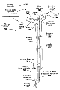
February 6, 2009, and entitled "Virtual White Lines for Indicating Planned
Excavation
Sites on Electronic Images;"
[0073] U.S. publication no. 2009-0202112-Al, published August 13, 2009,
filed
February 11, 2009, and entitled "Searchable Electronic Records of Underground
Facility
Locate Marking Operations;"
[0074] U.S. publication no. 2009-0204614-Al, published August 13, 2009,
filed
February 11, 2009, and entitled "Searchable Electronic Records of Underground
Facility
Locate Marking Operations;"
[0075] U.S. publication no. 2009-0327024-Al, published December 31,
2009, filed
June 26, 2009, and entitled "Methods and Apparatus for Quality Assessment of a
Field
Service Operation;"
[0076] U.S. publication no. 2010-0010862-Al, published January 14,
2010, filed
August 7, 2009, and entitled, "Methods and Apparatus for Quality Assessment of
a Field
Service Operation Based on Geographic Information;"
[0077] U.S. publication No. 2010-0010863-Al, published January 14, 2010,
filed
August 7, 2009, and entitled, "Methods and Apparatus for Quality Assessment of
a Field
Service Operation Based on Multiple Scoring Categories;"
[0078] U.S. publication no. 2010-0010882-Al, published January 14, 2010,
filed
August 7, 2009, and entitled, "Methods and Apparatus for Quality Assessment of
a Field
Service Operation Based on Dynamic Assessment Parameters;" and
-19-
CA 02750908 2011-07-21
[0079] U.S. publication no. 2010-0010883-Al, published January 14,
2010, filed
August 7, 2009, and entitled, "Methods and Apparatus for Quality Assessment of
a Field
Service Operation Based on Multiple Quality Assessment Criteria."
[0080] It should be appreciated that all combinations of the foregoing
concepts and
additional concepts discussed in greater detail below (provided such concepts
are not
mutually inconsistent) are contemplated as being part of the inventive subject
matter
disclosed herein. In particular, all combinations of claimed subject matter
appearing at the
end of this disclosure are contemplated as being part of the inventive subject
matter
disclosed herein. It should also be appreciated that terminology explicitly
employed
herein, should be accorded a meaning most consistent with the particular
concepts
disclosed herein.
BRIEF DESCRIPTION OF THE DRAWINGS
[0081] The drawings are not necessarily to scale, emphasis instead
generally being
placed upon illustrating the principles of the invention.
[0082] Figure 1 shows an example in which a locate and marking operation is
initiated
as a result of an excavator providing an excavation notice to a one-call
center.
[0083] Figure 2 illustrates one example of a conventional locate
instrument set
including a locate transmitter and a locate receiver.
[0084] Figures 3A and 3B illustrate a conventional marking device in
an actuated and
non-actuated state, respectively.
[0085] Figure 4 is a functional block diagram of a data acquisition
system including a
marking device for creating electronic records of marking operations and
displaying
facilities map information, according to some embodiments of the present
invention.
[0086] Figure 5 is a perspective view of the data acquisition system of
Figure 4,
illustrating an exemplary marking device upon which some embodiments of the
invention
may be implemented.
[0087] Figures 6A and 6B illustrate a portion of an actuation system of
the marking
device of Figure 5.
[0088] Figure 7 illustrates various components of the actuation system
of Figures 6A
and 6B.
-20-
CA 02750908 2011-07-21
[0089] Figure 8 illustrates an example of facilities map information
that may be
viewed on the display of the marking device.
[0090] Figure 9 illustrates a sketch representing an exemplary input
image that may be
viewed on the display of the marking device.
[0091] Figure 10 illustrates a map, representing an exemplary input image
that may be
viewed on the display of the marking device.
[0092] Figure 11 illustrates a construction/engineering drawing,
representing an
exemplary input image that may be viewed on the display of the marking device.
[0093] Figure 12 illustrates a land survey map, representing an
exemplary input image
that may be viewed on the display of the marking device.
[0094] Figure 13 illustrates a grid, overlaid on the
construction/engineering drawing of
Fig. 11, representing an exemplary input image that may be viewed on the
display of the
marking device.
[0095] Figure 14 illustrates a street level image, representing an
exemplary input
image that may be viewed on the display of the marking device.
[0096] Figure 15 illustrates an example of a video frame sequence of a
facilities map
that may be displayed on the display of a marking device, in accordance with
some
embodiments.
[0097] Figure 16 illustrates a flow diagram of a process for displaying
a facilities map
on the display of a marking device, in accordance with some embodiments.
[0098] Figure 17 illustrates a flow diagram of a process for overlaying
data on a
facilities map displayed on the display of a marking device.
[0099] Figure 18 shows a display device having a display field in which
one or more
display layers and/or sub-layers of marking information, landmark information
and/or
image/reference information may be selectively enabled or disabled for
display, according
to one embodiment of the present invention.
DETAILED DESCRIPTION
[00100] Following below are more detailed descriptions of various concepts
related to,
and embodiments of, inventive systems, methods and apparatus for viewing
facilities maps
-21-
CA 02750908 2011-07-21
information and/or other image information on a marking device. It should be
appreciated
that various concepts introduced above and discussed in greater detail below
may be
implemented in any of numerous ways, as the disclosed concepts are not limited
to any
particular manner of implementation. Examples of specific implementations and
applications are provided primarily for illustrative purposes.
[00101] Various embodiments of the present invention relate to a marking
device
capable of accessing and displaying various types of information derived from
one or
more facilities maps. In some embodiments, the marking device may have the
capability
to access one or more locally and/or remotely stored electronic facilities
maps or a
database of facilities map information, and select and display all or a
portion of a facilities
map that is of interest to a technician or other technician of the marking
device. As
explained in detail below, in some embodiments, the marking device may update
the
display of the facilities map information in essentially real-time (e.g.,
change one or more
of pan, zoom, orientation, etc.), as the marking device is in use, when
changes in the geo-
location and/or heading of the marking device are detected. In this manner,
the marking
device provides a convenient way for the locate technician to view and
interact with
facilities map information in real-time while conducting a locate and/or
marking operation
(and/or immediately before or after the marking operation).
[00102] In various aspects, the inventive concepts discussed herein generally
relate to
one of more of the following: 1) selection, from a local or remote
library/archive, of one or
more appropriate "base" facilities maps or facilities map data sets relating
to a given work
site/dig area; 2) manual or automated selection of an appropriate pan and/or
zoom
(resolution) for displaying, on a user interface/display of a marking device,
facilities map
information derived from the base facilities map(s); 3) appropriately
updating, if/as
necessary, displayed facilities map information while a marking device is used
during a
marking operation; 4) overlaying, on the displayed facilities map information,
marking
information relating to the marking operation; and 5) storing locally on the
marking
device, and/or transmitting from the marking device, facilities map
information and/or
overlaid marking information (e.g., for further processing, analysis and/or
subsequent
display).
[00103] Furthermore, in addition to facilities map information, it should be
appreciated
that the present disclosure contemplates other types of image information
being accessed
-22-
CA 02750908 2011-07-21
and displayed on a user interface/display of a marking device to facilitate
various aspects
of a locate and/or marking operation. For example, other types of maps (e.g.,
street/road
maps, polygon maps, tax maps, etc.), architectural, construction and/or
engineering
drawings, land surveys, and photographic renderings/images, and various
information
derived therefrom, including virtual white line (VWL) designations that
delimit, on a map
or other image, a planned excavation area, may be displayed on the marking
device and
may also be used as the basis for overlaying marking information relating to a
marking
operation.
[00104] I. Marking Device
[00105] One example of a marking device which may be configured to access,
view,
update, store, analyze and process facilities map information is described
below. It should
be appreciated that the marking device described below is merely one example
of a
marking device that may be configured for applications involving facilities
map
information and/or other image information, and that the invention is not
limited to
implementation on this marking device. In particular, other types of marking
devices may
be similarly configured as discussed herein, as well as various types of
locate devices and
combined marking and locate devices.
[00106] Figures 4 and 5 illustrate a functional block diagram and perspective
view,
respectively, of one example of a data acquisition system 100, including a
marking device
110 and optionally a remote computer 150, according to one embodiment of the
present
invention. One or both of the marking device 110 and the remote computer 150
of the
data acquisition system 100 may be configured to sense one or more actuations
of the
marking device 110 (e.g., to dispense marking material during a marking
operation), and
collect information based on one or more actuations of the marking device so
as to
generate an electronic record.
[00107] As shown in Figure 4, in one embodiment marking device 110 includes
control
electronics 112, the components of which are powered by a power source 114.
Power
source 114 may be any power source that is suitable for use in a portable
device, such as,
but not limited to, one or more rechargeable batteries, one or more non-
rechargeable
batteries, a solar photovoltaic panel, a standard AC power plug feeding an AC-
to-DC
converter, and the like.
-23-
CA 02750908 2011-07-21
[00108] The marking device 110 is configured to hold a marking dispenser 116,
which
as shown in Figure 5 is loaded into a marking material holder 140 of the
marking device
110. In one exemplary implementation, the marking dispenser 116 is an aerosol
paint
canister that contains paint; however, it should be appreciated that the
present invention is
not limited in this respect, as a marking material dispensed by the marking
device 110 may
be any material, substance, compound, and/or element, used to mark, signify,
and/or
indicate. Examples of marking materials may include, but are not limited to,
paint, chalk,
dye, and/or marking powder.
[00109] As also shown in Figure 4, in one embodiment control electronics 112
of
marking device 110 may include, but are not limited to, a processor 118, at
least a portion
of an actuation system 120 (another portion of which may include one or more
mechanical
elements), a local memory 122, a communication interface 124, a user interface
126, a
timing system 128, and a location tracking system 130.
[001101 The processor 118 may be any general-purpose processor, controller, or
microcontroller device. Local memory 122 may be any volatile or non-volatile
data
storage device, such as, but not limited to, a random access memory (RAM)
device and a
removable memory device (e.g., a universal serial bus (USB) flash drive, a
multimedia
card (MMC), a secure digital card (SD), a compact flash card (CF), etc.). As
discussed
further below, the local memory may store a marking data algorithm 134, which
may be a
set of processor-executable instructions that when executed by the processor
118 causes
the processor to control various other components of the marking device 110 so
as to
generate an electronic record 135 of a marking operation, which record also
may be stored
in the local memory 122 and/or transmitted in essentially real-time (as it is
being
generated) or after completion of a marking operation to a remote device
(e.g., remote
computer 150). In other aspects, the local memory 122 also may store a map or
image
viewer application 113 (hereafter simply "map viewer application"), and one or
more
facilities maps or facilities map data sets 166 and/or other images 168. As
discussed
further below, the one or more facilities maps/data sets 166 may in some
implementations
include a library of facilities maps, or a database of facilities map data,
for one or more
different types of facilities deployed in a geographical region.
1001111 In one exemplary implementation, a Linux-based processing system for
embedded handheld and/or wireless devices may be employed in the marking
device 110
-24-
CA 02750908 2011-07-21
to implement various components of the control electronics 112. For example,
the
Fingertip4TM processing system, including a Marvell PXA270 processor and
available
from InHand Electronics, Inc. (www.inhandelectronics.com/products/fingertip4),
may be
used. In addition to the PXA270 processor (e.g., serving as the processor
118), the
Fingertip4TM includes flash memory and SDRAM (e.g., serving as local memory
122),
multiple serial ports, a USB port, and other I/0 interfaces (e.g., to
facilitate interfacing
with one or more input devices and other components of the marking device),
supports a
variety of wired and wireless interfaces (WiFi, Bluetooth, GPS, Ethernet, any
IEEE 802.11
interface, or any other suitable wireless interface) to facilitate
implementation of the
communication interface 124, and connects to a wide variety of LCD displays
(to facilitate
implementation of a user interface/display). In yet other exemplary
implementations, the
processor 118 may be realized by multiple processors that divide/share some or
all of the
functionality discussed herein in connection with the processor 118. For
example, in one
implementation, an AtomTM processor available from Intel Corporation of Santa
Clara,
California, may be used alone or in connection with one or more PIC processors
to
accomplish various functionality described herein.
[00112] Communication interface 124 of marking device 110 may be any wired
and/or
wireless communication interface by which information may be exchanged between
marking device 110 and an external or remote device, such as a remote
computing device
that is elsewhere in the dig area (i.e., not a part of the marking device 110)
or outside the
dig area. For example, data that is provided by components of data acquisition
system 100
and/or stored in local memory 122 (e.g., one or more electronic records 135,
one or more
facilities maps 166) may be transmitted via communication interface 124 to a
remote
computer, such as remote computer 150, for processing. Similarly, one or more
facilities
maps 166 may be received from the remote computer 150 or one or more other
external
sources via the communication interface 124. Examples of wired communication
interfaces may include, but are not limited to, USB ports, RS232 connectors,
RJ45
connectors, Ethernet, and any combination thereof. Examples of wireless
communication
interfaces may include, but are not limited to, an Intranet connection,
Internet, Bluetooth
technology, Wi-Fi, Wi-Max, IEEE 802.11 technology (e.g., operating at a
minimum
bandwidth of 54 Mbps, or any other suitable bandwidth), radio frequency (RF),
Infrared
Data Association (IrDA) compatible protocols, Local Area Networks (LAN), Wide
Area
-25-
CA 02750908 2011-07-21
Networks (WAN), Shared Wireless Access Protocol (SWAP), any combination
thereof,
and other types of wireless networking protocols. The wireless interface may
be capable
of capturing signals that reflect a user's intent. For example, the wireless
interface may
include a microphone that can capture a user's intent by capturing the user's
audible
commands. Alternatively, the wireless interface may interact with a device
that monitors a
condition of the user, such as eye movement, brain activity, and/or heart
rate.
[00113] User interface 126 of marking device 110 may be any mechanism or
combination of mechanisms by which a user may operate data acquisition system
100 and
by which information that is generated by data acquisition system 100 may be
presented to
the user. For example, user interface 126 may include, but is not limited to,
a display
device (including integrated displays and external displays, such as Heads-Up
Displays
(HUDs)), a touch screen, one or more manual pushbuttons, a microphone to
provide for
audible commands, one or more light-emitting diode (LED) indicators, one or
more toggle
switches, a keypad, an audio output (e.g., speaker, buzzer, and alarm), and
any
combination thereof. In one implementation, the user interface 126 includes a
"menu/on"
button to power up the marking device and provide a menu-driven graphical user
interface
(GUI) displayed by the display device (e.g., menu items and/or icons displayed
on the
display device) and navigated by the technician via a joystick or a set of
four
"up/down/left/right" buttons, as well as a "select/ok" button to take some
action pursuant
to the selection of a menu item/icon. As described below, the display may also
be used in
some embodiments of the invention to display information relating to one or
more
facilities maps and/or one or more other images germane to a locate and/or
marking
information, as well as information relating to a placement of marking
material in a dig
area, a location of an underground facility in a dig area, or any other
suitable information
that may be displayed based on information acquired to create an electronic
record 135.
[00114] In various embodiments, the one or more interfaces of the marking
device
110¨including the communication interface 124 and user interface 126¨may be
used as
input devices to receive information to be stored in the memory 122, to
facilitate various
functions of the marking device and/or to be logged as part of an electronic
record of a
marking operation. In some cases, marking information received via the
interface(s) (e.g.,
via the communication interface 124) may include ticket information regarding
underground facilities to be marked during a marking operation. As another
example,
-26-
CA 02750908 2011-07-21
using an interface such as the user interface 126, service-related information
may be input,
including an identifier for the marking device used by the technician, an
identifier for a
technician, and/or an identifier for the technician's employer. Alternatively,
some or all of
the service-related information similarly may be received via the
communication interface
124 (and likewise some or all of the ticket information may be received via
the user
interface 126). As also noted above, facilities map information and/or other
image
information also may be received via the communication interface 124.
[00115] The actuation system 120 of marking device 110 shown in the block
diagram
of Figure 4 may include both electrical and mechanical elements according to
various
embodiments discussed in further detail below, and for purposes of
illustration is shown in
Figure 4 as included as part of the control electronics 112. The actuation
system 120 may
include a mechanical and/or electrical actuator mechanism (e.g., see the
actuator 142
shown in Figure 5) to provide one or more signals or stimuli as an input to
the actuation
system 120. Upon receiving one or more signals or stimuli (e.g.,
actuation/triggering by a
locate technician or other user), the actuation system 120 causes marking
material to be
dispensed from marking dispenser 116. In various embodiments, the actuation
system 120
may employ any of a variety of mechanical and/or electrical techniques (e.g.,
one or more
switches or other circuit components, a dedicated processor or the processor
118 executing
instructions, one or more mechanical elements, various types of transmitters
and receivers,
or any combination of the foregoing), as would be readily appreciated by those
of skill in
the relevant arts, to cause the marking dispenser 116 to dispense marking
material in
response to one or more signals or stimuli. The actuation system 120 also
provides one or
more output signals in the form of an actuation signal 121 to the processor
118 to indicate
one or more actuations of the marking device, in response to which the
processor 118 may
acquire/collect various marking information and log data into the electronic
record 135.
Additional details of exemplary actuation system implementations are provided
below in
connection with Figures 5 through 7.
[00116] In some embodiments, the actuation system 120 may be configured so as
not to
cause marking material to be dispensed from marking dispenser 116 in response
to one or
more signals or stimuli; rather, the actuation system may merely facilitate a
logging of
data from one or more input devices in response to operation of an
actuator/trigger,
without necessarily dispensing marking material. In some instances, this may
facilitate
-27-
CA 02750908 2011-07-21
"simulation" of a marking operation (i.e., simulating the dispensing of
marking material)
by providing an actuation signal 121 to the processor 118 indicating one or
more
simulated actuation events, in response to which the processor may cause the
logging of
various data for creating an electronic record without any marking material
actually being
dispensed.
[00117] Location tracking system 130 of marking device 110 constitutes another
type
of input device that provides marking information, and may include any device
that can
determine its geographical location to a certain degree of accuracy. For
example, location
tracking system 130 may include a global positioning system (GPS) receiver or
a global
navigation satellite system (GNSS) receiver. A GPS receiver may provide, for
example,
any standard format data stream, such as a National Marine Electronics
Association
(NMEA) data stream, or other data formats. An error correction component 131
may be,
but is not limited to, any mechanism for improving the accuracy of the
geographic
information provided by location tracking system 130; for example, error
correction
component 131 may be an algorithm for correcting any offsets (e.g., due to
local
disturbances in the atmosphere) in the geo-location data of location tracking
system 130.
While shown as part of a local location tracking system of the marking device
110, error
correction component 131 alternatively may reside at a remote computing
device, such as
remote computer 150. In other embodiments, location tracking system 130 may
include
any device or mechanism that may determine location by any other means, such
as
performing triangulation by use of cellular radiotelephone towers.
[00118] In one exemplary implementation, the location tracking system 130 may
include an ISM300F2-05-V0005 GPS module available from Inventek Systems, LLC
of
Westford, Massachusetts (see www.inventeksys.com/html/ism30012-c5-v0005.html).
The
Inventek GPS module includes two UARTs (universal asynchronous
receiver/transmitter)
for communication with the processor 118, supports both the SLRF Binary and
NMEA-
0183 protocols (depending on firmware selection), and has an information
update rate of 5
Hz. A variety of geographic location information may be requested by the
processor 118
and provided by the GPS module to the processor 118 including, but not limited
to, time
(coordinated universal time ¨ UTC), date, latitude, north/south indicator,
longitude,
east/west indicator, number and identification of satellites used in the
position solution,
number and identification of GPS satellites in view and their elevation,
azimuth and SNR
-28-
CA 02750908 2011-07-21
values, and dilution of precision values. Accordingly, it should be
appreciated that in
some implementations the location tracking system 130 may provide a wide
variety of
geographic information as well as timing information (e.g., one or more time
stamps) to
the processor 118.
[00119] In another embodiment, location tracking system 130 may not reside
locally on
marking device 110. Instead, location tracking system 130 may reside on any on-
site
computer, which serves as a location reference point, to which the location of
marking
device 110 may be correlated by any other means, such as, but not limited to,
by a
triangulation technique between the on-site computer and marking device 110.
[00120] In some embodiments, control electronics 112 may also include one or
more of
an electronic compass 160, an inclinometer 170, and one or more accelerometers
172. An
inclinometer is an instrument for measuring angles of slope (or tilt) or
inclination of an
object with respect to gravity. The inclinometer 170 may be any commercially
available
inclinometer device. In one example, inclinometer 170 may be a digital device
for sensing
the inclination of the marking device 110 in which it is installed (i.e.,
senses angle of
spray). An accelerometer is a device for measuring acceleration and gravity-
induced
reaction forces. A multi-axis accelerometer is able to detect magnitude and
direction of
the acceleration as a vector quantity. The acceleration specification may be
in terms of g-
force, which is a measurement of an object's acceleration. The accelerometer
172 may be
any commercially available accelerometer device, including, for example, Part
No.
ADXL330 sold by Analog Devices of Wilmington, MA. In one example,
accelerometer
172 may be used for detecting the rate of movement of the marking device 110
in which it
is installed. Electronic compass 160 may be any commercially available
electronic
compass, including, for example, the 0S5000-S sold by OceanServer Technology,
Inc. of
Fall River, MA, the SP3002D sold by SPARTON Corporation of Brooksville, FL,
the
PNI-PRIME sold by PNI Sensor Corp. of Santa Rosa, CA, the Revolution GS sold
by
True North LLC of Maynard, MA, or the HMR3400 sold by Honeywell International,
Inc.
of Morristown, NJ.
[00121] With respect to other input devices of the marking device 110 that may
provide
marking information, the control electronics 112 may also include a timing
system 128
having an internal clock (not shown), such as a crystal oscillator device, for
processor 118.
Additionally, timing system 128 may include a mechanism for registering time
with a
-29-
CA 02750908 2011-07-21
certain degree of accuracy (e.g., accuracy to the minute, second, or
millisecond) and may
also include a mechanism for registering the calendar date. In various
implementations,
the timing system 128 may be capable of registering the time and date using
its internal
clock, or alternatively timing system 128 may receive its time and date
information from
the location tracking system 130 (e.g., a GPS system) or from an external
timing system,
such as a remote computer or network, via communication interface 124. In yet
other
implementations, a dedicated timing system for providing timing information to
be logged
in an electronic record 135 may be optional, and timing information for
logging into an
electronic record may be obtained from the location tracking system 130 (e.g.,
GPS
latitude and longitude coordinates with a corresponding time stamp). Timing
information
may include, but is not limited to, a period of time, timestamp information,
date, and/or
elapsed time.
[001221 Marking material detection mechanism 132 of the marking device 110
shown
in Figure 4 is another type of input device that provides marking information,
and may be
any mechanism or mechanisms for determining a presence or absence of a marking
dispenser 116 in or otherwise coupled to the marking device 110, as well as
determining
certain attributes/characteristics of the marking material within marking
dispenser 116
when the dispenser is placed in or coupled to the marking device. As shown in
Figure 5,
in some embodiments the marking material detection mechanism 132 may be
disposed
generally in an area proximate to a marking material holder 140 in which a
marking
dispenser 116 may be placed.
1001231 For example, in one embodiment, the marking material detection
mechanism
132 may include one or more switch devices (e.g., a make/break single
pole/single throw
contact switch) disposed at one or more points along the marking material
holder 140 and
electrically coupled to the processor 118. The switch device(s) may also be
coupled to
ground or a DC supply voltage, such that when the switch device is in a first
state (e.g.,
closed/making contact) the ground or DC supply voltage is passed to the
processor 118
(e.g., via an I/O pin of the processor which provides an interrupt to, or is
periodically
monitored by, the processor), and when the switch is in a second state (e.g.,
open/no
contact) the ground or DC supply voltage is not passed to the processor 118.
When the
marking dispenser 116 is present in the holder 140, the switch device(s) is in
one of two
possible states and when there is no marking dispenser the switch device(s) is
in another of
-30-
CA 02750908 2011-07-21
the two possible states (e.g., the marking dispenser, when present, may
depress the switch
device(s) so as to make contact and pass the ground/DC voltage to the
processor). In this
manner, the marking material detection mechanism 132 may provide a signal to
the
processor indicating the presence or absence of the marking dispenser 116 in
the marking
device 110.
[00124] The marking material detection mechanism 132 also or alternatively may
include a barcode reader to read barcode data from a dispenser 116 and/or a
radio-
frequency identification (RFID) reader for reading information from an RFID
tag that is
provided on marking dispenser 116. The RFID tag may include, for example, a
unique
serial number or universal product code (UPC) that corresponds to the brand
and/or type
of marking material in marking dispenser 116. The type of information that may
be
encoded within the RFID tag on marking dispenser 116 may include product-
specific
information for the marking material, but any information of interest may be
stored on an
RFID tag. For example, user-specific information and/or inventory-related
information
may be stored on each RFID tag for a marking dispenser 116 to facilitate
inventory
tracking of marking materials. In particular, an identifier for a technician
may be stored
on an RFID tag when the technician is provided with a marking dispenser 116,
and
information relating to weight, amount dispensed, and/or amount remaining may
be
written to the RFID tag whenever the marking dispenser is used.
[00125] In one exemplary implementation, the marking material detection
mechanism
132 may include a Micro RWD MEFARE-ICODE RFID reader module available from IB
Technology (Eccel Technology Ltd) of Aylesbury, Buckinghamshire, UK (see
www.ibtechnology.co.uk/ products/icode.htm). The Micro RWD reader module
includes
an RS232 communication interface to facilitate communication between the
processor 118
and the reader module (e.g., via messages sent as a string of ASCII
characters), and
supports both reading information from an RFID tag attached to a marking
dispenser as
well as writing information to an RFID tag attached to the marking dispenser.
In one
aspect of an exemplary implementation, an antenna constituted by one or more
turns of
wire (e.g., two turns of awg 26 wire, 6.5 cm in diameter, about 1 uH) is
coupled to the
Micro RWD reader module and disposed in the marking material holder 140 of the
marking device 110 (see Figure 5), proximate to a marking dispenser 116 when
placed in
the holder 140, so as to capture close near field signals (e.g., from an RFID
tag on the
-31-
CA 02750908 2011-07-21
dispenser, within about 2 inches) and exclude far field signals. In another
aspect, the
Micro RWD reader module may be configured to read RFID tags having an ICODE
SLI
format (e.g., ISO 15693 ICODE SLI). In yet another aspect, an RFID tag may be
affixed
to an aerosol paint can serving as the marking dispenser, such that the tag
conforms to a
plastic cap of the paint can and is disposed at a particular location relative
to a notch in the
cap (e.g., 90 degrees +/- 15 degrees from the notch) that allows access to the
spray nozzle
of the can and is in a relatively predictable position substantially aligned
with the antenna
when the paint can is placed in the marking material holder 140. Examples of
RFID tags
suitable for this purpose are available from BCS Solutions, Inc. (see
www.bcssolutions.com/solutions/rfid) and include, but are not limited to, the
HF Bullseye
Wet Inlay SLA Round 40.
[00126] In yet other embodiments, marking material detection mechanism 132 may
alternatively or further be configured to detect properties of marking
material as it is
dispensed. For example, the marking material detection mechanism may include
one or
more of an optical sensor, an olfactory sensor, an auditory sensor (e.g., a
microphone), a
weight sensor, and any combination thereof. For example, in one embodiment an
optical
sensor in the marking device may be used to identify the composition and/or
type of
marking material in the marking dispenser by analyzing light reflected by the
material as it
is dispensed. Similarly, an olfactory sensor may be used to identify one or
more
characteristics of the marking material based on an odor profile of the
material, and an
auditory sensor may be used to identify the difference between paint being
sprayed from
an aerosol can and aerosol without paint being sprayed from a can (e.g., as
the dispenser
becomes emptied of paint).
[001271 In one embodiment, information provided by one or more input devices
of the
marking device 110 (e.g., the timing system 128, the location tracking system
130, the
marking material detection mechanism 132, the user interface 126, the
communication
interface 124) is acquired and logged (stored in memory) upon actuation of the
actuation
system 120 (e.g., triggering an actuator). Some embodiments of the invention
may
additionally or alternatively acquire/log information from one or more input
devices at one
or more times during or throughout an actuation, such as when a technician is
holding a
mechanical or electrical actuator for some period of time and moving to
dispense marking
material in a line. In various aspects of such embodiments, marking
information derived
-32-
CA 02750908 2011-07-21
from one or more input devices may be collected at a start time of an
actuation, at one or
more times during an actuation, and in some cases at regular intervals during
an actuation
(e.g., several times per second, once per second, once every few seconds).
Further, some
marking information may be collected at an end of an actuation, such as time
information
that may indicate a duration of an actuation.
1001281 Additionally, it should be appreciated that while some marking
information
may be received via one or more input devices at the start of each marking
operation and
upon successive actuations of the marking device, in other cases some marking
information, as well as facilities maps information and/or other image
information, may be
collected by or provided to the marking device prior to a marking operation
(e.g., on
power-up or reset of the marking device, as part of an electronic instruction
or dispatch by
a locate company, and/or in response to a request/query from a locate
technician), and
stored in local memory 122 for subsequent use by the marking device (e.g.,
display of
information via the user interface display 146, later incorporation into an
electronic record,
etc.). For example, prior to a given marking operation and one or more
actuations of the
marking device, one or more of ticket information, service-related
information, facilities
maps information, and other image information, may have already been received
(e.g., via
the communication interface 124 and/or user interface 126) and stored in local
memory
122. Pursuant to a marking operation (e.g., immediately before, during and/or
after a
marking operation), information previously received via the interface(s) may
be retrieved
from the local memory (if stored there initially), and displayed and/or
entered into an
electronic record as appropriate, in some case together with information
collected pursuant
to one or more actuations of the marking device. In some implementations,
ticket
information and/or service-related information may be received via the
interface(s) and
stored in an entry in the electronic record 135 "directly" in response to one
or more
actuations of the marking device (e.g., without being first stored in local
memory).
1001291 In sum, according to embodiments of the present invention, various
marking
information from one or more input devices, as well as facilities map
information and/or
other image information, regardless of how or when it is received, may be
displayed in
various manners and/or stored in memory of the marking device (e.g., in an
electronic
record of a marking operation), and in some implementations at least some of
the marking
information may be logged pursuant to one or more actuations of the marking
device.
-33-
CA 02750908 2011-07-21
[00130] In various implementations, the optional remoter computer 150 of the
data
acquisition system 100 may be any external computer system with which the
marking
device 110 communicates (e.g., via the communications interface 124). In one
embodiment, the remote computer 150 may be a centralized computer, such as a
central
server of an underground facility locate service provider. In another
embodiment, remote
computer 150 may be a computer that is at or near the work site (i.e., "on-
site"), e.g., a
computer that is present in a locate technician's vehicle. As shown in Figs. 4
and 5, the
remote computer may also or alternatively store one or more of the marking
data
algorithm 134, the map viewer application 113, one or more facilities maps 166
(e.g., a
library/archive of facilities maps), and one or more images 168. To this end,
in some
exemplary implementations, an example of a remote computer 150 may include an
image
server or a facilities maps server to provide facilities maps/images to the
marking device
110.
[00131] Whether resident and/or executed on either the marking device 110 or
the
remote computer 150, as noted above the marking data algorithm 134 includes a
set of
processor-executable instructions (e.g., stored in memory, such as local
memory 122 of
the marking device) that, when executed by processor 118 of the marking device
110 or
another processor, processes information (e.g., various marking information)
collected in
response to (e.g., during) one or more actuations of the marking device 110,
and/or in
some cases before or after a given actuation or series of actuations. As also
discussed
above, according to various embodiments the actuations of marking device 110
may effect
both dispensing marking material and logging of marking information, or merely
logging
of marking information for other purposes (e.g., simulating the dispensing of
marking
material) without dispensing marking material. In either situation, marking
data algorithm
134, when executed by the processor 118, may cause the processor to perform
collection,
logging/storage (creation of electronic records), and in some instances
further processing
and analysis of various marking information with respect to marking device
actuations.
[00132] While the functionality of various components of the marking device
110 was
discussed above in connection with Figure 4, Figure 5 shows some structural
aspects of
the marking device 110 according to one embodiment. For example, the marking
device
110 may include an elongated housing 136 in which is disposed one or more
elements of
the actuation system 120, one or more elements of the control electronics 112
and the
-34..
CA 02750908 2011-07-21
power source 114. Elongated housing 136 may be hollow or may contain certain
cavities
or molded compartments for installing any components therein, such as the
various
components of marking device 110 that are shown in Figure 4. The elongated
housing
136 and other structural elements associated with the housing, as discussed
below, may be
formed of any rigid, semi-rigid, strong, and lightweight material, such as,
but not limited
to, molded plastic and aluminum.
[00133] Incorporated at a proximal end of elongated housing 136 may be a
handle 138,
which provides a convenient grip by which the user (e.g., the locate
technician) may carry
the marking device 110 during use (i.e., the exemplary marking device depicted
in Figure
5 is intended to be a hand-held device). In one implementation, the power
source 114 may
be provided in the form of a removable battery pack housing one or more
rechargeable
batteries that are connected in series or parallel in order to provide a DC
voltage to
marking device 110, and disposed within a compartment in the handle 138. Such
an
arrangement facilitates use of conventional removable/rechargeable battery
packs often
employed in a variety of cordless power tools, in which the battery pack
similarly is
situated in a handle of the tool. It should be appreciated, however, that the
power source
114 in the form of a battery pack may be disposed in any of a variety of
locations within or
coupled to the elongated housing 136.
[00134] As also shown in Figure 5, mounted near handle 138 is user interface
126,
which may include a display 146. The display 146 may be a touch screen display
to
facilitate interaction with a user/technician, and/or the user interface also
may include one
or more buttons, switches, joysticks, a keyboard, and the like to facilitate
entry of
information by a user/technician. One or more elements of the control
electronics 112
(e.g., the processor 118, memory 122, communication interface 124, and timing
system
128) also may be located in the proximal end of the elongated housing in the
vicinity of
the user interface 126 and display 146. As with the power source 114, it
should be
appreciated that one or more elements of the control electronics 112 may be
disposed in
any of a variety of locations within or coupled to the elongated housing 136.
[00135] In the embodiment of Figure 5, the location tracking system 130
similarly may
be positioned on the proximal end of the elongated housing 136 to facilitate
substantially
unobstructed exposure to the atmosphere; in particular, as illustrated in
Figure 5, the
location tracking system 130 may be situated on an a ground plane 133
(providing an
-35-
CA 02750908 2011-07-21
electrical ground at least at the antenna frequency of the location tracking
system, e.g., at
approximately 1.5 GHz) that extends from the proximal end of the housing 136
and is
approximately parallel to the ground, surface or pavement when the marking
device is
being normally operated by a technician (so as to reduce signal modulation
with subtle
movements of the marking device).
[00136] As also shown in Figure 5, incorporated at the distal end of elongated
housing
136 is a marking dispenser holder 140 for holding one or more marking
dispensers 116
(e.g., an aerosol paint canister). Dispenser 116 may be one or more
replaceable dispensers
or one or more reusable refillable dispensers (including a fixed reservoir
forming a part of
the device 110) or any other suitable dispenser. Also situated at the distal
end of the
housing is the marking material detection mechanism 132 to detect a presence
or absence
of the marking dispenser 116 in the marking material holder 140, and/or one or
more
characteristics of the marking material 148, as well as an actuation mechanism
158, which
in some implementations may constitute part of the actuation system 120 and be
employed
to interact with the marking dispenser 116 so as to effect dispensing of the
marking
material 148.
[00137] With respect to the actuation system 120, as shown in Figure 5, at
least a
portion of the actuation system 120 is indicated generally along the length of
the elongated
housing for purposes of illustration. More specifically, however, in various
implementations the actuation system 120 may include multiple components
disposed in
various places in, on or coupled to the marking device 110. For example, in
the
embodiment of Figure 5, the actuation system 120 includes an actuator 142,
which for
example may be a mechanical mechanism provided at the handle 138 in the form
of a
trigger that is pulled by a finger or hand of an user/technician. The
actuation system 120
further includes the actuation mechanism 158 disposed at the distal end of the
marking
device that is responsive to the actuator 142 to dispense marking material. In
general, in
various exemplary implementations as discussed in further detail below, the
actuation
system 120 may employ any of a variety of mechanical and/or electrical
techniques to
cause the marking dispenser 116 to dispense marking material 148 in response
to one or
more signals or stimuli. In the embodiment shown in Figure 5, the
signal/stimulus is
initially provided to the actuation system via the mechanical actuator 142;
i.e., a locate
technician or other user triggers (e.g., pulls/depresses) the actuator 142 to
provide a
-36-
CA 02750908 2011-07-21
signal/stimulus to the actuation system 120, which in turn operates the
actuation
mechanism 158 to dispense marking material in response to the signal/stimulus.
[00138] In response to the signal/stimulus provided by the actuator 142, as
discussed
above the actuation system may also provide an actuation signal 121 to the
processor 118
to indicate an actuation. As discussed in further detail below in connection
with Figure
15, pursuant to the execution by the processor 118 of the marking data
algorithm 134, the
actuation signal 121 may be used to cause the logging of information that is
provided by
one or more components of the marking device 110 so as to generate an
electronic record
of the marking operation.
[00139] Figures 6A and 6B illustrate a portion of the actuation system 120
according to
one embodiment of the present invention. Figure 6A shows the actuator 142 in
an un-
actuated state, whereas Figure 6B shows the actuator 142 in an actuated state
(in which a
signal/stimulus is provided by the actuator). In the example of Figures 6A and
6B, the
actuator 142 is coupled to a mechanical coupler 152 which extends along a
length of the
elongated housing and is in turn coupled to a mechanical actuation mechanism
158 at the
distal end of the housing (not shown in Figures 6A and 6B) that ultimately
effects
dispensing of marking material when the actuator is in the actuated state. The
portion of
the actuation system 120 shown in Figures 6A and 6B also includes a sensor 160
which is
configured to provide an actuation signal 121 to the processor 118 to indicate
one or both
of the respective actuated and un-actuated states of the actuator 142.
[00140] In one implementation, the sensor 160 may include a switch
device (e.g., a
make/break single pole/single throw contact switch) disposed along the handle
138 of the
marking device such that, when pulled, the actuator contacts (e.g., depresses)
the switch
causing a state of the switch to toggle. In another implementation, the sensor
160 may
include a switch device such as a reed (magnetic) switch disposed at some
point along the
length of the elongated housing; in such an implementation, the mechanical
coupler 152
may have a magnet disposed along it at an appropriate position relative to the
reed switch,
such that movement of the mechanical coupler 152 upon actuation of the
actuator 142
causes a state of the reed switch to toggle. Electrically, a switch device
serving as the
sensor 160 may be coupled to ground or a DC supply voltage, such that when the
switch
device is in a first state (e.g., closed/making contact) the ground or DC
supply voltage is
passed to the processor 118 (e.g., via an I/0 pin of the processor which
provides an
-37-
CA 02750908 2011-07-21
interrupt to, or is periodically monitored by, the processor), and when the
switch is in a
second state (e.g., open/no contact) the ground or DC supply voltage is not
passed to the
processor 118. In this manner, the sensor 160 may provide the actuation signal
121 to the
processor indicating actuation (and release) of the actuator 142.
[00141] Figure 7 illustrates various components of an actuation system 120
according
to other embodiments of the present invention. Generally speaking, the
actuation system
120 may include the actuator 142 and the sensor 160 to detect actuation and
release of the
actuator 142 (and also provide a corresponding actuation signal 121
representing same to
the processor 118). While a "trigger-pull" type of actuator 142 is shown
primarily for
purposes of illustration in Figure 5, it should be appreciated that more
generally an
actuator of the actuation system 120 may be implemented by any form or
combination of a
lever, switch, program, processor, screen, microphone for capturing audible
commands,
and the like, as discussed above. For example, in one implementation, a
microphone may
serve as both the actuator 142 and the sensor 160 shown in Figure 7 to provide
an
actuation signal 121 based on audible commands, so as to effect voice-
activated actuation
of the marking device.
[00142] Figure 7 also shows that the actuation system 120 of this embodiment
includes
a link transmitter 168 coupled and responsive to the sensor 160 to transmit
one or more
signals and/or other stimulus via an actuation link 164, and a link receiver
162 to receive
the one or more signals and/or other stimulus from the actuation link 164. In
response to
such signals and/or other stimulus, the link receiver 162 operates the
actuation mechanism
158. The link transmitter 168, the link 164, and the link receiver 162 may
include one or
more electrical and/or mechanical components. For example, the link receiver
162 may
include a linear solenoid mechanically coupled to the actuation mechanism 158
and whose
movement is responsive to one or more signals and/or stimuli received from the
link 164.
In various exemplary implementations, the link transmitter 168 and the link
164 simply
may include a wire that couples the sensor 160 to the solenoid to activate the
solenoid
upon changes of state in the actuation signal 121. Alternatively, the
transmitter 168 may
be an RF transmitter that is activated in response to the actuation signal
121, the link 164
may be a wireless link, and the receiver 162 may include an RF receiver.
[00143] Other examples of transmitter/link/receiver combinations include, but
are not
limited to, an acoustic transmitter/link/receiver (e.g., a sound wave source
that provides a
-38-
CA 02750908 2011-07-21
sound wave of a certain tone, duration, and/or amplitude when the actuator is
actuated, and
a corresponding sound wave detector), an optical transmitter/link/receiver
(e.g., a light or
laser source that provides an optical signal of a certain wavelength,
duration, and/or
amplitude when the actuator is actuated, and a corresponding optical
detector), a fluid
transmitter/link/receiver (e.g., a fluid system that provides a fluid control
output of a
certain volume, pressure, and/or duration when the actuator is actuated, and a
corresponding fluid sensor for sensing the presence of, for example, a short
blast of water
of a certain volume, pressure, and/or duration to indicate an actuation; the
fluid system
may be, for example, a closed-loop system that has a source reservoir at the
top of the
marking device, a fluid line in proximity with the fluid sensor, a return
reservoir for
capturing water during the actuation process, and appropriate pressure
regulation and
ducts for cycling water from the return reservoir back to the source
reservoir), and an air
transmitter/link/receiver (e.g., an air system that provides an air control
output of a certain
volume, pressure, and/or duration when the actuator is actuated, and a
corresponding air
sensor for sensing the presence of, for example, a blast or puff of air of a
certain volume,
pressure, and/or duration to indicate an actuation).
[00144] While not explicitly shown in Figure 7, in yet other embodiments it
should be
appreciated that the sensor 160 may be coupled to the processor 118 (to
provide the
actuation signal 121 representing actuation/release of the actuator), and in
turn the
processor may provide a signal to the link transmitter 168, such that
dispensing of marking
material may in part be under the control of the processor 118 executing
particular
instructions for this purpose. More specifically, while in some
implementations
dispensing of marking material may be directly responsive to actuation of the
actuator
(and cease upon release of the actuator), in other implementations dispensing
of marking
material may be initiated in some manner upon actuation of the actuator, but
then
continued dispensing of marking material may not necessarily be dictated by
continued
actuation, or release, of the actuator. Rather, the processor 118 may provide
one or more
signals or commands to the link transmitter 168 to govern dispensing of
marking material
in some manner that does not necessarily track each actuation and release of
the actuator.
[00145] II. Facilities Maps
[00146] As noted above and discussed in further detail below, various
embodiments of
the present invention relate to accessing and displaying facilities map
information. A
-39-
CA 02750908 2011-07-21
facilities map is any physical, electronic, or other representation of the
geographic location,
type, number, and/or other attributes of a facility or facilities. Facilities
maps may be
supplied by various facility owners and may indicate the geographic location
of the facility
lines (e.g., pipes, cables, and the like) owned and/or operated by the
facility owner. For
example, facilities maps may be supplied by the owner of the gas facilities,
power
facilities, telecommunications facilities, water and sewer facilities, and so
on.
[00147] As indicated above, facilities maps may be provided in any of a
variety of
different formats. As facilities maps often are provided by facility owners of
a given type
of facility, typically a set of facilities maps includes a group of maps
covering a particular
geographic region and directed to showing a particular type of facility
disposed/deployed
throughout the geographic region. One facilities map of such a set of maps is
sometimes
referred to in the relevant arts as a "plat."
[00148] Perhaps the simplest form of facilities maps is a set of paper maps
that cover a
particular geographic region. In addition, some facilities maps may be
provided in
electronic form. An electronic facilities map may in some instances simply be
an
electronic conversion (i.e., a scan) of a paper facilities map that includes
no other
information (e.g., electronic information) describing the content of the map,
other than
what is printed on the paper maps.
[00149] Alternatively, however, more sophisticated facilities maps also are
available
which include a variety of electronic information, including geographic
information and
other detailed information, regarding the contents of various features
included in the maps.
In particular, facilities maps may be formatted as geographic information
system (GIS)
map data, in which map features (e.g., facility lines and other features) are
represented as
shapes and/or lines, and the metadata that describes the geographic locations
and types of
map features is associated with the map features. In some examples, a GIS map
data may
indicate a facility line using a straight line (or series of straight lines),
and may include
some symbol or other annotation (e.g., a diamond shape) at each endpoint of
the line to
indicate where the line begins and terminates. From the foregoing, it should
be
appreciated that in some instances in which the geo-locations of two
termination or end-
points of a given facility line may be provided by the map, the geo-location
of any point
on the facility line may be determined from these two end-points.
-40-
CA 02750908 2011-07-21
[00150] Examples of a wide variety of environmental landmarks and other
features that
may be represented in GIS facilities map data include, but are not limited to:
landmarks
relating to facilities such as pedestal boxes, utility poles, fire hydrants,
manhole covers and
the like; one or more architectural elements (e.g., buildings); and/or one or
more traffic
infrastructure elements (e.g., streets, intersections, curbs, ramps, bridges,
tunnels, etc.).
GIS facilities map data may also include various shapes or symbols indicating
different
environmental landmarks relating to facilities, architectural elements, and/or
traffic
infrastructure elements.
[00151] Examples of information provided by metadata include, but are not
limited to,
information about the geo-location of various points along a given line, the
termination
points of a given line (e.g., the diamond shapes indicating the start and end
of the line), the
type of facility line (e.g., facility type and whether the line is a service
line or main), geo-
location of various shapes and/or symbols for other features represented in
the map
(environmental landmarks relating to facilities, architectural elements,
and/or traffic
infrastructure elements), and type information relating to shapes and/or
symbols for such
other features.
[00152] The GIS map data and metadata may be stored in any of a variety of
ways. For
example, in some embodiments, the GIS map data and metadata may be organized
into
files, where each file includes the map data and metadata for a particular
geographic
region. In other embodiments, the GIS map data and metadata may be stored in
database
and may be indexed in the database by the geographical region to which the map
data and
metadata corresponds.
[00153] Facilities maps may include additional information that may be useful
to
facilitate a locate and/or marking operation. For example, various information
that may be
included in a legend of the facilities map, or otherwise associated with the
facilities map
(e.g., included in the metadata or otherwise represented on the map), may
include, but is
not limited to, a date of the facilities map (e.g., when the map was first
generated/created,
and/or additional dates corresponding to updates/revisions), a number of
revisions to the
facilities map (e.g., revision number, which may in some instances be
associated with a
date), one or more identifiers for a source, creator, owner and/or custodian
of the facilities
map (e.g., the owner of the facility type represented in the map), various
text information
-41-
CA 02750908 2011-07-21
(e.g., annotations to update one or more aspects or elements of the map), and
any other
legend information that may be included or represented in the map.
1001541 For facilities maps in electronic form, a variety of digital formats
of facilities
maps may be used including, but not limited to, a vector image format that is
the typical
output format of computer-aided design (CAD) tools. In one example, some
facilities
maps may be in a DWG ("drawing") format, which is a format that used for
storing two
and three dimensional design data and metadata, and is a native used by
several CAD
packages including AutoCAD, Intellicad, and PowerCAD. However, those skilled
in the
art will recognize that facilities maps may be in any of several vector and/or
raster image
formats, such as, but not limited to, DWG, DWF, DGN, PDF, TIFF, MFI, PMF, and
JPG.
[00155] As noted above, in some instances in which facilities maps are in a
vector
image format, a certain line on the facilities map may be represented by a
starting point
geo-location, an ending point geo-location, and metadata about the line (e.g.,
type of line,
depth of line, width of line, distance of line from a reference point (i.e.,
tie-down),
overhead, underground, line specifications, etc.). According to one embodiment
of the
present invention as discussed in greater detail below, to facilitate display
of facilities map
information relating to multiple different types of facilities, each vector
image may be
assembled in layers, in which respective layers correspond, for example, to
different types
of facilities (e.g., gas, water, electric, telecommunications, etc.). In one
aspect of such an
embodiment, each layer is, for example, a set of vector images that are
grouped together in
order to render the representation of the certain type of facility.
[00156] Figure 8 shows an example of a visual representation of a portion of
an
electronic facilities map 600. In this example, facilities map 600 is a
telecommunications
facilities map that is supplied by a telecommunications company. Facilities
map 600
shows telecommunications facilities in relation to certain landmarks, such as
streets and
roads, using lines and shapes. As discussed above, the electronic facilities
map may
include metadata indicating what various lines, symbols and/or shapes
represent, and
indicating the geo-location of these lines, symbols and/or shapes. With
respect to
exemplary environmental landmarks and other features, facilities map 600 may
include
both visual information (graphics and text) and metadata relating to utility
poles 602,
manhole 604, streets 606, and any of a variety of other landmarks and features
that may
fall within the geographic area covered by the facilities map 600.
-42-
CA 02750908 2011-07-21
[00157] III. Other Types of Image Information
[00158] As also noted above and discussed in further detail below, various
embodiments of the present invention relate to accessing and displaying not
only facilities
map information but other types of image information as well and, as with
facilities map
information, different images can be selected for viewing on the marking
device at
different times, according to various criteria. In some exemplary
implementations, an
"input image" may be stored in local memory 122 of the marking device and/or
retrieved
from the optional remote computer 150 (e.g., via the communication interface
124) and
then stored in local memory, accessed, and various information may be derived
therefrom
for display (e.g., all or a portion of the input image, metadata associated
with the input
image, etc.).
[00159] For purposes of the present application, an input image is any image
represented by source data that is electronically processed (e.g., the source
data is in a
computer-readable format) to display the image on a display device. An input
image may
include any of a variety of paper/tangible image sources that are scanned
(e.g., via an
electronic scanner) or otherwise converted so as to create source data (e.g.,
in various
formats such as XML, PDF, JPG, BMP, etc.) that can be processed to display the
input
image, including scans of paper facilities maps. An input image also may
include an
image that originates as source data or an electronic file without necessarily
having a
corresponding paper/tangible copy of the image (e.g., an image of a "real-
world" scene
acquired by a digital still frame or video camera or other image acquisition
device, in
which the source data, at least in part, represents pixel information from the
image
acquisition device).
[00160] In some exemplary implementations, input images may be created,
provided,
and/or processed by a geographic information system (GIS) that captures,
stores, analyzes,
manages and presents data referring to (or linked to) location, such that the
source data
representing the input image includes pixel information from an image
acquisition device
(corresponding to an acquired "real world" scene or representation thereof),
and/or
spatial/geographic information ("geo-encoded information").
-43-
CA 02750908 2011-07-21
[00161] In view of the foregoing, various examples of input images and
source data
representing input images, to which the inventive concepts disclosed herein
may be
applied, include but are not limited to:
= Manual "free-hand" paper sketches of the geographic area (which may
include
one or more buildings, natural or man-made landmarks, property boundaries,
streets/intersections, public works or facilities such as street lighting,
signage,
fire hydrants, mail boxes, parking meters, etc.);
= Various maps indicating surface features and/or extents of geographical
areas,
such as street/road maps, topographical maps, military maps, parcel maps, tax
maps, town and county planning maps, call-center and/or facility polygon
maps, virtual maps, etc. (such maps may or may not include geo-encoded
information);
= Architectural, construction and/or engineering drawings and virtual
renditions
of a space/geographic area (including "as built" or post-construction
drawings);
= Land surveys, i.e., plots produced at ground level using references to
known
points such as the center line of a street to plot the metes and bounds and
related location data regarding a building, parcel, utility, roadway, or other
object or installation;
= A grid (a pattern of horizontal and vertical lines used as a reference) to
provide representational geographic information (which may be used "as is"
for an input image or as an overlay for an acquired "real world" scene,
drawing, map, etc.);
= "Bare" data representing geo-encoded information (geographical data
points)
and not necessarily derived from an acquired/captured real-world scene (e.g.,
not pixel information from a digital camera or other digital image acquisition
device). Such "bare" data may be nonetheless used to construct a displayed
input image, and may be in any of a variety of computer-readable formats,
including XML); and
-44-
CA 02750908 2011-07-21
= Photographic renderings/images, including street level, topographical,
satellite, and aerial photographic renderings/images, any of which may be
updated periodically to capture changes in a given geographic area over time
(e.g., seasonal changes such as foliage density, which may variably impact the
ability to see some aspects of the image).
[00162] It should also be appreciated that source data representing an input
image may
be compiled from multiple data/information sources; for example, any two or
more of the
examples provided above for input images and source data representing input
images, or
any two or more other data sources, can provide information that can be
combined or
integrated to form source data that is electronically processed to display an
image on a
display device.
[00163] Various examples of input images as discussed above are provided in
Figs. 9-
14. For example, Fig. 9 shows a sketch 1000, representing an exemplary input
image; Fig.
10 shows a map 1100, representing an exemplary input image; Fig. 11 shows a
construction/engineering drawing 1300, representing an exemplary input image;
Fig. 12
shows a land survey map 1400, representing an exemplary input image; Fig. 13
shows a
grid 1500, overlaid on the construction/engineering drawing 1300 of Fig. 11,
representing
an exemplary input image; and Fig. 14 shows a street level image 1600,
representing an
exemplary input image.
[00164] IV. Displaying Facilities Map Information and/or Other Image
Information On
A Marking Device
[00165] In some embodiments, marking device 110 may display various
information
relating to one or more facilities maps or one or more input images on display
146. For
example, processor(s) 118 may access facilities map data (e.g., from a file or
a database)
stored in local memory 122 or may retrieve facilities map data stored on
remote computer
150 and may display on display 146 facilities maps based on the facilities map
data.
[00166] In some embodiments, processor 118 may execute a map viewer
application
113 for displaying facilities maps and/or input images. The map viewer
application 113
may be a custom application or any conventional viewer application that is
capable of
reading in electronic facilities maps data or other input images, and
rendering all or a
portion of the electronic facilities maps data/input images to an image that
can be viewed
-45-
CA 02750908 2011-07-21
on display 146. Examples of conventional map viewer applications suitable for
purposes
of some embodiments of the present invention include, but are not limited to,
the
Bentley viewer application from Bentley Systems, Inc. (Exton, PA) and the
ArcGIS
viewer application from Environmental Systems Research Institute (Redlands,
CA).
While the discussion below initially focuses on the display of facilities map
information
for purposes of illustrating some of the inventive concepts disclosed herein,
it should be
appreciated that the various concepts discussed below apply generally to the
display of
other types of image information as well.
[00167] Processor 118 may select a map to be displayed on display 146 in any
of
variety of ways. In some embodiments, a technician using the marking device
may
manually select a map to be displayed. For example, the technician may access
a list of
facilities maps available in local memory 122 and/or stored on remote computer
using user
interface 126 (e.g., via a menu-driven graphics user interface on the user
interface 126)
and may select a desired map from the list. In response, processor 118 may
access the
corresponding map data and render an image of the map or a portion of the map
on display
146 (e.g., using the map viewer application 113). The technician may then also
adjust the
particular portion of the map that is displayed on display 146 by using user
interface 146
to pan or scroll to the desired portion of the map, and may additionally
select the desired
zoom level at which the portion of the map is displayed.
[00168] In some embodiments, processor 118, in addition to or instead of
providing the
capability for a user/technician to manually select facilities map information
to be
displayed on display 146, may also automatically select a facilities map and
display all or
a portion of the selected facilities map on display 146. A variety of
techniques may be
used to automatically select a facilities map to be displayed on display 146,
as well as a
default pan and/or zoom for the selected map, and the invention is not limited
to any
particular technique.
[00169] In some embodiments, a facilities map may be automatically selected
for
display based, at least in part, on the type of facility being marked by the
marking device
and/or the current location of the marking device (e.g., obtained from the
location tracking
system).
-46-
CA 02750908 2011-07-21
[00170] For example, in some embodiments, processor 118 may determine the type
of
facility being marked by the marking device (e.g., using marking material
detection
mechanism 132) and select a facilities map based on that facility type. As
discussed above,
marking material detection mechanism may determine the type of facility being
marked by
determining the color of the marking material loaded into and/or being
dispensed by the
marking device. Because each marking material color corresponds to a
particular type of
facility, the color of the marking material may be used to select a facilities
map. Table 1
shows an example of the correspondence of marking material color to the type
of facility
to be marked.
Table 1 Correspondence of color to facility type
Marking
Facility Type
material color
Red Electric power lines, cables or conduits, and lighting
cables
Yellow Gas, oil, steam, petroleum, or other hazardous liquid or
gaseous
materials
Orange Communications, cable TV, alarm or signal lines, cables,
or conduits
Blue Water, irrigation, and slurry lines
,
Green Sewers, storm sewer facilities, or other drain lines
White Proposed excavation
Pink Temporary survey markings
Purple Reclaimed water, irrigation and slurry lines
Black Mark-out for errant lines
[00171] Thus, for example, if processor 118 determines from marking material
detection mechanism that the color of the marking material loaded into and/or
being
dispensed by the marking device is red, then electric power lines may be
determined as the
type of facility being marked. As another example, if processor 118 determines
from
marking material detection mechanism that the color of the marking material
loaded into
and/or being dispensed by the marking device is yellow, then gas lines may be
determined
as the type of facility being marked.
[00172] In some embodiments, rather than determine the type of facility being
marked
based on the color of the marking material, processor 118 may prompt, via user
interface
-47-
CA 02750908 2011-07-21
126, the technician using the marking device to manually input the type of
facility being
marked, and may accept the technician's input as the type of facility being
marked. In yet
another embodiment, facility type information may be derived from the ticket
information,
discussed above in section I; in particular, ticket information typically
includes one or
more member codes representing facility owners of different types of
facilities, and
available ticket information may be parsed to determine relevant facility
types based on
one or more member codes present in the ticket information. Accordingly, in
some
implementations, one or more appropriate facilities maps may be selected,
before the
marking operation and independently of the marking material and/or other
manual input
from the user, based on facility type information derived from the ticket
information.
[00173] In some embodiments, once the type of facility being marked has been
determined, processor 118 may select a facilities map or facilities map data
to render a
display on display 146 by determining the current geo-location of the marking
device and
selecting a facilities map or facilities map data corresponding to the
facility type being
marked based on the current location of the marking device. Processor 118 may
determine
the current geo-location of the marking device from location tracking system
130 and may
select a facilities map or facilities map data for the type of facility being
marked that
includes the current geo-location. For example, if the current location of the
marking
device is 2650.9348,N,08003.5057,W, and the type of facility is electric power
lines,
processor 118 may access facilities map data that covers an area including
2650.9348,N,08003.5057,W and includes data indicating the location of electric
power
lines in this area, and may render a map image on display 146 showing the area
and
location of the electric power lines in that area.
[00174] Other techniques for automatically selecting a facilities map or
facilities map
data to render a displayed image may be used. For example, in some
embodiments,
processor 118 may select a facilities map or facilities map data to be
displayed using
information from the ticket for a particular locate operation. For example, an
address from
the ticket may be used to select facilities map data that covers the
geographic area in
which the address is located. In some embodiments, one or more member codes
from the
ticket may be used to determine a facility type that is to be marked and
automatically
select the appropriate facilities map data for that facility type. For
example, if a ticket
includes a member code for the gas company, processor 118 may automatically
select gas
-48-
CA 02750908 2011-07-21
facilities map data. In some situations, a ticket may include multiple member
codes
corresponding to different utility types. In such situations, standard
operating procedure
may be used to determine which facilities map to automatically select first.
For example,
a ticket may include member codes for the gas company and the electric
company.
Standard operating procedure may be specify that gas is to be marked before
electric and,
as such, processor 118 may automatically select the gas facilities map data to
be displayed
first and, once the gas locate and marking operation is complete, may
automatically select
the electric facilities map to be displayed next.
[00175] In some embodiments, information about the entity that requested that
the
locate operation be performed may be used in automatically selecting
facilities map data.
For example, if the electric company requested that the locate operation be
performed,
processor 118 may automatically select the electric facilities map data to be
visually
rendered and displayed.
[00176] In addition, in some embodiments, facilities map data may be selected
based on
a virtual white line (VWL) image that includes markings imposed on an image
that delimit
an area in which excavation is planned. Thus, for example, processor 118 may
select
facilities map data that includes the area indicated by the markings.
[00177] In some embodiments, once facilities map data has been automatically
selected,
a portion of the facilities map or facilities map data to render an image on
display 146 may
be identified. That is, the facilities map data that has been automatically
selected may
cover an area significantly larger than the work site/dig area at which a
locate and/or
marking operation is being conducted, and thus only a portion of the selected
map data
needs to be displayed on display 146. Accordingly, in some embodiments, the
map viewer
application 113 executing on processor 118 may display only a portion of the
facilities
map data on display 146. The portion of the facilities map to be displayed may
be selected
in a variety of ways. For example, in some embodiments, a technician may have
the
ability to manually select the portion of a facilities map that is desired to
be displayed on
display 146. As an example, once a particular facilities map has been
automatically
selected, the facilities map may be displayed on display 146 at a default zoom
level,
centered at the current geo-location of the marking device. If the technician
desires to a
view a different portion of the map or adjust the zoom level, the technician
may pan or
-49-
CA 02750908 2011-07-21
scroll to a different part of the map and adjust the zoom level using the
controls of user
interface 126.
[001781 In some embodiments, in addition to or instead of providing a
technician with
the capability to manually select a portion of a facilities map data to be
displayed,
processor 118 may automatically select a portion of the facilities map data to
be displayed.
For example, in some embodiments, processor 118 may select a portion of the
selected
facilities map data to be displayed based on one or more aspects of the ticket
information
pursuant to which the locate and/or marking operation is being performed. In
particular,
as noted above, the ticket information generally includes some description of
the work
site/dig area (in which excavation, digging or otherwise disturbing the ground
is
anticipated). While conventionally such information about the work site/dig
area may be
included as text comments in the ticket information, in some instances the
ticket
information may include a digital image (e.g., an aerial image) of a
geographic area
surrounding/proximate to the work site, on which are placed (e.g., via an
electronic
drawing tool) one or more dig area indicators to indicate or delimit a dig
area. These
marked-up digital images may be saved together with metadata pertaining to
various
information in the images.
[001791 An example of a drawing application that may be used to create such
marked-
up images including dig area indicators is described in U.S. Patent
Publication No. 2009-
0238417 published September 24, 2009, entitled "Virtual white lines for
delimiting
planned excavation sites;" U.S. Patent Publication No. 2010-0201706 published
August 12,
2010, entitled "Virtual white lines for delimiting planned excavation sites of
staged
excavation projects;" U.S. Patent Publication No. 2010-0201690 published
August 12,
2010, entitled "Virtual white lines (VWL) application for indicating a planned
excavation
or locate path."
[00180] In one example, the dig area indicators in a marked-up image may
include two-
dimensional (2D) drawing shapes, shades, points, symbols, coordinates, data
sets, or other
indicators to indicate on a digital image the dig area in which excavation is
to occur. To
generate the electronic image having dig area indicators, an image (e.g., an
aerial image)
of the work site may be sent to an excavator via a network, the excavator may
use a
computing device executing the drawing application to create a marked-up image
by
marking up the image to include one or more dig area indicators precisely
delimiting one
-50-
CA 02750908 2011-07-21
or more dig areas within the work site and, in response, the marked-up image
may be
received from the excavator via the network.
[00181] As noted above, a marked-up image may include metadata corresponding
to
any markings or content in the image; in particular, geographic information
including
geographic coordinates (e.g., latitude and longitude values) for any dig area
indicators on
the marked-up image may accompany or be included in an image file as metadata,
and
these geographic coordinates may be employed in a variety of manners to select
a portion
of the facilities map data to be displayed on display 146.
[00182] For example, in some embodiments, the portion of the facilities map
data to be
displayed may be selected to include all or a portion of the dig area as
indicated on the
marked-up image. In particular, in one exemplary implementation, geographic
coordinates associated with a single dig area indicator may be used to select
facilities map
contents that relates only to a geographic area including the geographic
coordinates for the
dig area indicator, or contents that falls within a predetermined radius of
the geographic
coordinates for the dig area indicator or a polygon-shaped buffer zone around
the
geographic coordinates for the dig area indicator. In yet another example,
geographic
coordinates associated with multiple dig area indicators that delimit a
specific dig are may
be used to select only contents of the facilities map that corresponds to the
delimited dig
area. In yet another embodiment, the contents of the facilities map that
corresponds to the
delimited dig area may be displayed with a "buffer frame" around the delimited
dig area
(e.g., to provide some margins for the viewed subject matter). Accordingly, it
should be
appreciated that in some embodiments, the dig area indicator coordinates may
identify a
plurality of points along a perimeter of the delimited dig area, and these
coordinates may
be used to select specific geographic information from the facilities maps
(e.g., filter out
geographic information outside of the delimited dig area). In other
embodiments, the dig
area indicator coordinates may identify a single point, in which case the
coordinates may
be used to select particular information based at least in part on the
coordinates for the
single point.
[00183] In some embodiments, the map viewer application 113 executing on
processor
118 may automatically select an orientation of the map or portion of the map
that is
displayed on display 146 based on the direction in which a technician of the
marking
device is moving. In some conventional techniques for displaying map
information, a
-51-
CA 02750908 2011-07-21
displayed map generally is oriented so that north is at the top of the display
and south is at
the bottom of the display. However, the inventors have appreciated that when
displaying a
facilities map or portion thereof on a marking device during a locate and/or
marking
operation, orienting the map such that the direction in which the technician
is moving is at
the top of the map may aid the technician in identifying the location of
underground
facilities relative to his or her current position. Thus, for example, if the
technician is
walking north, then the map viewer application may display the selected
portion of the
map such that north is at the top of the screen. If the technician turns left
and is walking
west, then the map viewer application may re-orient the selected portion of
the map such
that west is at the top of the screen. In this manner, the map viewer
application 113
executing on processor 118 may update the portion and/or the orientation of
the facilities
map that is being displayed on display 146 in essentially real-time (e.g.,
update one or
more of pan, zoon, and orientation as the technician moves from one place to
another
during the operation).
[00184] The map viewer application 113 may determine the direction in which a
technician is walking using any of a variety of techniques. For example, in
some
embodiments, processor 118 may monitor the current geo-location of the marking
device
as indicated by location tracking system 130, determine the direction in which
the marking
device is moving based on changes in the geo-location, and provide this
direction to the
map viewer application. For example, in some embodiments processor 118 may
determine the direction in which the marking device is moving by obtaining the
current
heading from the electronic compass.
1001851 In some embodiments, marking device 110 may include other devices that
may
be used to determine the direction in which the marking device is moving, such
as a
compass, an accelerometer, and/or an inclinometer. Thus, in some embodiments,
processor 118 may use these devices instead of or in addition to location
tracking system
130 to determine the direction in which the marking device is moving. For
example, in
some embodiments, the compass may be used to determine a heading in which the
marking device is moving. In other embodiments, the accelerometer and/or
inclinometer
may be used to determine the direction in which the marking device is moving.
[00186] To demonstrate the concept of automatically orienting and positioning
a
portion of a facilities map based on technician/device movement and heading,
Figure 15
-52-
CA 02750908 2011-07-21
illustrates an example of a video frame sequence 400 that may be displayed on
display 146
of marking device 110 as a technician moves the marking device to different
geo-locations
during a locate and/or marking operation. To illustrate video frame sequence
400, Figure
15 shows an example facilities map 410, which is the facilities map to be
displayed on
display 146. Facilities map 410 shows, for example, an intersection 412 of
Roosevelt
Avenue, which runs east and west, and Walnut Street, which runs north and
south.
Installed along Roosevelt Avenue and/or Walnut Street is a first underground
facility 414
and a second underground facility 416. By way of example, video frame sequence
400
shows a frame sequence that is presented on display 146 (e.g., by the map
viewer
application 113) to the technician while in the process of locating and/or
marking the first
underground facility 414. Each frame of video frame sequence 400 represents a
segment
of facilities map 410 that is being displayed.
[00187] Referring to Figure 15, as the locate technician moves in a northerly
direction
along Walnut Street, frame 1 of video frame sequence 400 that is displayed on
display 146
shows underground facility 414 at the south end of Walnut Street with respect
to facilities
map 410. Additionally, frame 1 is oriented on display 146 with a north
heading.
[00188] As the locate technician continues to move in a northerly direction
along
Walnut Street, frame 2 of video frame sequence 400 that is displayed on
display 146
shows underground facility 414 while approaching intersection 412 of
facilities map 410.
Additionally, frame 2 is still oriented on display 146 with a north heading.
[00189] As the locate technician continues to move in a northerly direction
through
intersection 412, frame 3 of video frame sequence 400 that is displayed on
display 146
shows underground facility 414 at intersection 412. Additionally, frame 3 is
still oriented
on display 114 with a north heading.
[00190] As the locate technician changes direction and moves in a westerly
direction
along Roosevelt Avenue, frame 4 of video frame sequence 400 that is displayed
on display
146 shows underground facility 414 while exiting intersection 412 along
Roosevelt
Avenue. Additionally, frame 4 the orientation of facilities map 410 on display
146 has
been updated from a north heading to a west heading.
[00191] As the locate technician continues to move in a westerly direction
along
Roosevelt Avenue, frame 5 of video frame sequence 400 that is displayed on
display 146
-53-
CA 02750908 2011-07-21
shows underground facility 414 at the west end of Roosevelt Avenue with
respect to
facilities map 410. Additionally, frame 5 is still oriented on display 146
with a west
heading.
[00192] The inventors have appreciated that, in some situations where the
locate
technician is moving in a particular direction, the locate technician may
reach a location
that is at the end of a the portion of the map that is currently being
displayed, such that if
the technician were to continue to move along a vector that includes a
component in that
direction, his or her location will no longer be a location on the portion of
the map that is
currently being displayed, but rather may be a location that is in a different
map portion.
[00193] Thus, in some embodiments, when a location technician moves from a
location
that is on the map portion currently being displayed to a location that is not
on the map
portion that is currently being displayed, processor 118 may determine that
the technician
has moved off the map portion that is currently being displayed. Processor 118
may then
identify and select additional map data (e.g., stored in the local memory 122
of the
marking device, or retrieved from a library/archive stored on remote computer
150) that
includes the location to which the technician has moved and cause the map
viewer
application 113 to display this other map, in a manner similar to that
discussed above in
connection with appropriate selection of maps/images for display.
[00194] In addition, in some embodiments, it may be desired to display a map
such that
the current location of the technician is roughly centered on the display. In
this way, as the
technician moves, the portion of the map that is displayed is adjusted so that
the
geographic location of technician on the map is displayed roughly in the
center of the
display. In such embodiments, the technician may be at a geographic location
that is near
or at the end of the currently displayed map portion. Thus, if the current
location of the
technician were to be displayed at roughly the center of the display, then a
portion of the
display may be left blank because the map data that belongs in that portion of
the display
is not in the map currently being displayed. Thus, in some embodiments, to
address this
issue, processor 118 may determine when the technician is at a location that
warrants
additional map data to be displayed on the display at the same time, determine
which
additional map data includes the desired data, stitch together a map image
using the
additional map data, and cause this "stitched together" image to be displayed
on the
display.
-54-
CA 02750908 2011-07-21
[00195] While the concepts described immediately above (e.g., updating pan,
zoom and
or orientation of displayed content based on technician/device movement and
heading)
were discussed for purposes of illustration using facilities map information,
it should be
appreciated that the foregoing discussion applies similarly to other types of
image
information (e.g., from one or more of the input images discussed above in
Section III).
[00196] Figure 16 illustrates a flow diagram of a process 500 for selecting
and viewing
facilities map information or other image information on a marking device,
according to
one embodiment of the present invention. Process 500 begins at act 512 where
the type of
facility to be marked is established manually or automatically using, for
example, any of
the techniques discussed above. The process then continues to act 514, where
the location
tracking system of the marking device is queried for the current geo-location
information.
The geo-location data from location tracking system 158 may be provided, in a
variety of
different formats, including for example, in degrees, minutes, and seconds
(i.e., DDD
MM' SS.S"), degrees and decimal minutes (DDD MM.MMM), decimal degrees
(DDD.DDDDD ), and/or any combination thereof.
[00197] The process next continue to act 516, where facilities map data that
matches
the determined facility type determined in act 512 and the geo-location
determined in act
514 is identified. The process then continues to act 518, where the map viewer
application
reads in the identified facilities map data, preparing to present an image of
this facilities
map on the display of the marking device. The processor then continues to act
520, where
the current heading (i.e., the direction in which the marking device is
moving) is
determined from, for example, the location tracking system, compass,
inclinometer, and/or
accelerometer. Once the current heading is determined, the process continues
to act 522,
where a map or map image segment is oriented according to the determined
heading and
centered according to the current geo-location of the marking device, and the
facilities
map image is presented on the display of the marking device.
[00198] In some embodiments, the marking device may alert the technician when
he or
she is at a location of a facility line, as indicated by the facilities map
data. Thus, in some
embodiments, the process may continue to act 524, where an alert to the locate
technician
may be generated based on comparing current geo-location of the marking device
to the
geo-location of the facilities of the displayed facilities map. In particular,
in one
exemplary implementation, the geo-location of the facilities of the displayed
facilities map
-55-
CA 02750908 2011-07-21
constitutes "reference information," to which "field information" in the form
of the geo-
location of the marking device (e.g., respective geo-locations of dispensed
marking
material) may be compared. Various methods and apparatus for comparing field
information in the context of locate and marking operations to reference
information
derived from facilities maps is discussed in U.S. Publication No. 2010-
0088164, published
April 8, 2010, and entitled, "Method And Apparatus For Analyzing Locate And
Marking
Operations With Respect To Facilities Maps".
[00199] In one example, processor 118 may compare the geo-location data of
location
tracking system 130 to the geo-location information in the displayed
facilities map. When
the two geo-locations substantially match (within a certain acceptable
tolerance), an
audible indicator, such as a buzzer or alarm may be activated, a tactile
indicator such as a
device that vibrates the handle of the marking device, and/or a visual
indicator, such as an
LED of user interface 126, may be activated in order to alert the locate
technician that he
or she is at or near the location of the target facility to be marked.
[00200] In other embodiments, if the location of the marking device differs
from the
location at which the facilities map(s) indicate the facility line to be
marked is located by
at least a threshold distance (e.g. six feet or any other suitable threshold
distance),
processor 118 may cause an alert (e.g., an audible indicator, a tactile
indicator, and/or a
visual indicator) to the technician to be activated. In addition, any
discrepancies between
the locations at which marking material was dispensed and the locations of the
facility
lines to be marked as indicated on the facilities map may be logged and later
evaluated to
determine whether the discrepancy is a result of facilities map inaccuracy or
locate
technician error.
[00201] As shown in Figure 16, the acts of process 500 may repeat any number
of times
and at any programmed frequency (e.g., every 100 milliseconds) until the
locate operation
is complete. With each iteration of the acts of process 500, the map viewer
application
updates (or refreshes) the display with the current facilities map information
in order to
reflect any changing geo-location and/or heading of the marking device as the
technician
performs the locate operation.
[00202] IV. Overlay of Marking Information on Displayed Facilities Map
Information
or Other Image Information
-56-
CA 02750908 2011-07-21
[00203] The inventors have appreciated that, as a technician using a marking
device
dispenses marking material during a locate and marking operation, it may be
useful to
overlay, on displayed facilities map information or other displayed image
information,
electronic marks that indicate where the marking material was dispensed. This
provides
the locate technician with a visual representation of where marking material
was dispensed
relative to the location of facility lines shown on the facilities map, and
may accordingly
provide a sense of how close the marking material that he or she dispensed is
to the
location of the facility lines, as indicated on the map. In addition, in some
situations, it
may be desirable to overlay one or more indicators, such as a "you are here"
icon or a
pointer icon on the displayed facilities map or other image information to
provide the
technician with a visual representation of his or her current location on the
displayed
portion of the map.
[00204] Figure 17 is an example of a process that may be used to overlay data,
such as
electronic markings indicative of geo-locations at which marking material was
dispensed,
a present location indicator or a "you are here" icon indicative of the
current location of
the marking device, or any other type of data, on displayed facilities map
information or
other image information, according to one embodiment of the present invention.
[00205] The process of Figure 17 begins at act 901, where the geo-location
data of the
marking information to be overlaid (e.g., geo-location data corresponding to
physical
locate marks, or a current location mark) is determined/collected. For
example, if the
information to be overlaid is a current location mark or "you are here" icon
indicative of
the current location of the marking device, the current location of the
marking device may
be determined from location tracking system 130. If the information to be
overlaid is an
electronic mark indicative of a geo-location at which marking material was
dispensed (e.g.,
to create a physical locate mark on ground, pavement or other surface), the
geo-location
data at which marking material was dispensed may be collected from the
location tracking
system 130 in response to actuation of the marking device and/or determined,
for example,
from the electronic record 135 generated and stored by the marking device.
That is, as
discussed above, in some embodiments, each time the marking device 110 is
actuated, the
location tracking system may be polled to provide one or more geo-location
data points
that may be overlaid on displayed facilities map information or other image
information
essentially in real-time as the data is collected, and/or the geo-location
data may be logged
-57-
CA 02750908 2011-07-21
as data event entries in the electronic record 135 and the electronic record
135 may be
accessed thereafter to obtain geo-location data for overlaying on displayed
facilities map
or other image information.
1002061 Table 2 below shows another example of marking device data that may be
captured as the result of, for example, one or more actuations of a marking
device.
Specifically, Table 2 illustrates multiple "actuation data sets" of an
electronic record of a
marking operation as generated by a marking device, in which each actuation
data set
includes information associated with multiple actuation event entries logged
during a
corresponding actuation of the marking device and dispensing of marking
material. Table
2 shows three actuation data sets of an electronic record, corresponding to
three actuations
of the marking device (e.g., act-1, act-2, and act-3). As may be appreciated
from the
information shown in Table 2, in some embodiments multiple pieces of geo-
location data
may be logged for each actuation of a marking device (in addition to various
other
information). However, it should be appreciated that the present invention is
not limited
in this respect, and that multiple pieces of geo-location data per actuation
are not
necessarily required for overlay on displayed facilities map or other image
information.
Table 2 Example actuation data set for act-1
Service provider ID 0482
User ID 4815
Device ID 7362
Ti timestamp data 12-Jul-2008; 09:35:15.2
T2 timestamp data 12-Jul-2008; 09:35:16.1
Duration (At) 00:00:00.9
Ti geo-location data 2650.9348,N,08003.5057,W
1st interval location 2650.9353,N,08003.5055,W
data
act-1 2" interval location 2650.9356,N,08003.5055,W
data
Nth interval location 2650.9246,N,08003.5240,W
data
T2 geo-location data 2650.9255,N,08003.5236,W
Product data Color=Red, Brand=ABC, Type/Batch = 224B-1
Locate request data Requestor: XYZ Construction Company,
Requested service address: 222 Main St, Orlando, FL
-58-
CA 02750908 2011-07-21
Table 2 (continued) Example actuation data set for act-2
Service provider ID 0482
User ID 4815
Device ID 7362
Ti timestamp data 12-Jul-2008; 09:35:17.5
T2 timestamp data 12-Jul-2008; 09:35:18.7
Duration (At) 00:00:01.2
_ Ti geo-location data 2650.9256,N,08003.5234,W
1st interval location 2650.9256,N,08003.5226,W
data
act-2 2"d interval location 2650.9256,N,08003 .5217,W
data
Nth interval location 2650.9260,N,08003 .5199,W
data
T2 geo-location data 2650.9266,N,08003.5196,W
Product data Color=Red, Brand=ABC, Type/Batch = 224B-1
Locate request data Requestor: XYZ Construction Company,
Requested service address: 222 Main St, Orlando, FL
Table 2 (continued) Example actuation data set for act-3
Service provider ID 0482
User ID 4815
Device ID 7362
Ti timestamp data 12-Jul-2008; 09:35:18.7
T2 timestamp data 12-Jul-2008; 09:35:19.8
duration (At) 00:00:01.1
T1 geo-location data 2650.9273,N,08003 .5193 ,W
rt interval location 2650.9281,N,08003.5190,W
data
act-3 2'd interval location 2650.9288,N,08003.5188,W
data
Nth interval location 2650.9321,N,08003 .5177,W
data
T2 geo-location data 2650.9325,N,08003.5176,W
Product data Color=Red, Brand¨ABC, Type/Batch = 224B-1
Locate request data Requestor: XYZ Construction Company,
Requested service address: 222 Main St, Orlando, FL
-59-
CA 02750908 2011-07-21
[00207] Thus, the geo-location(s) at which marking material was dispensed may
be
obtained from these electronic records, and/or may be collected essentially in
real-time as
the marking operation is being performed. Once the geo-location data to be
overlaid on
the displayed information is determined, the process continues to optional act
903, where
this geo-location data may be converted, if necessary, to the spatial
reference frame used
by the facilities map (or other image) from which the information displayed on
the display
146 is derived.
[00208] As known in the relevant art, a geographic or "global" coordinate
system (i.e.,
a coordinate system in which geographic locations on Earth are identified by a
latitude and
a longitude value, e.g., (LAT,LON)) may be used to identify geographic
locations of
locate marks and a facility line. In a "geocentric" global coordinate system
(i.e., a
coordinate system in which the Earth is modeled as a sphere), latitude is
defined as the
angle from a point on the surface of a sphere to the equatorial plane of the
sphere, whereas
longitude is defined as the angle east or west of a reference meridian between
two
geographical poles of the sphere to another meridian that passes through an
arbitrary point
on the surface of the sphere. Thus, in a geocentric coordinate system, the
center of the
Earth serves as a reference point that is the origin of the coordinate system.
However, in
actuality the Earth is not perfectly spherical, as it is compressed towards
the center at the
poles. Consequently, using a geocentric coordinate system can result in
inaccuracies.
[00209] In view of the foregoing, the Earth is typically modeled as an
ellipsoid for
purposes of establishing a global coordinate system. The shape of the
ellipsoid that is
used to model the Earth and the way that the ellipsoid is fitted to the geoid
of the Earth is
called a "geodetic datum." In a "geodetic" global coordinate system, the
latitude of a point
on the surface of the ellipsoid is defined as the angle from the equatorial
plane to a line
normal to the reference ellipsoid passing through the point, whereas the
longitude of a
point is defined as the angle between a reference plane perpendicular to the
equatorial
plane and a plane perpendicular to the equatorial plane that passes through
the point. Thus,
geodetic latitude and longitude of a particular point depends on the geodetic
datum used.
[00210] A number of different geodetic global coordinate systems exist that
use
different geodetic datums, examples of which include WGS84, NAD83, NAD27,
OSGB36, and ED50. As such, a geographic point on the surface of Earth may have
a
different latitude and longitude values in different coordinate systems. For
example, a
-60-
CA 02750908 2011-07-21
stop sign at the corner Maple St. and Main St. may have a latitude and
longitude of (LAT),
LON1) in the WGS84 coordinate system, but may have a latitude and longitude of
(LAT2,
LON2) in the NAD83 coordinate system (where LAT) LAT2 and/or LON) LON2).
Thus, when comparing one geographic point to another geographic point to
determine the
distance between them, it is desirable to have both geographic points in the
same global
coordinate system.
[00211] Additionally, when determining a geographic location based on
information
derived from a map (e.g., a facilities map), the coordinate system provided by
the map
may not be a global coordinate system, but rather may be a "projected"
coordinate system.
As appreciated in the relevant art, representing the curved surface of the
Earth on a flat
surface or plane is known as a "map projection." Representing a curved surface
in two
dimensions causes distortion in shape, area, distance, and/or direction.
Different map
projections cause different types of distortions. For example, a projection
could maintain
the area of a feature but alter its shape. A map projection defines a relation
between
spherical coordinates on the globe (i.e., longitude and latitude in a global
coordinate
system) and flat planar x,y coordinates (i.e., a horizontal and vertical
distance from a point
of origin) in a projected coordinate system. A facilities map may provide
geographic
location information in one of several possible projected coordinate systems.
[00212] Thus, to overlay geo-location data (e.g., obtained from the location
tracking
system 130 of the marking device) on displayed facilities map information (or
other image
information), it is desirable to have the geo-location data and the facilities
map
information represented in the same geodetic global coordinate system or
projected
coordinate system (projected from the same geodetic geographical coordinate
system).
For example, in some embodiments, the geo-location data points obtained by the
location
tracking system of the marking device may be provided as geo-location data in
the
WGS84 coordinate system (i.e., the coordinate system typically used by GPS
equipment),
whereas the facilities map information may be expressed in the NAD83
coordinate system.
Thus, at act 903, the geo-location data coordinates provided by the location
tracking
system of the marking device may be converted to the NAD83 coordinate system
so that
they may be appropriately overlaid on the displayed facilities map
information.
1002131 The process next continues to act 905, where the data, converted if/as
appropriate, may be overlaid on the information displayed on display 146, such
that
-61-
CA 02750908 2011-07-21
display 146 displays both the facilities map/image information and the
overlaid data. For
example, if the technician dispensed marking material at
2650.9273,N,08003.5193,W
(decimal degrees) in the coordinate system used by the facilities map, an
electronic mark
may be overlaid on the displayed facilities map at the portion of the
facilities map that
corresponds to 2650.9273,N,08003.5193,W. Similarly, if the current location of
the
marking device is 2680.5243,N,08043.4193,W in the coordinate system used by
the
facilities map, then a "you are here" icon may be overlaid on the displayed
facilities map
at the portion of the facilities map that corresponds to
2680.5243,N,08043.4193,W.
[00214] Any one of a number of different techniques may be used to overlay
data on
the displayed facilities map or image. In some embodiments, the data to be
visually
rendered on the facilities map or image is mapped to a display field of the
display device
to ensure that the geo-location data for the data to be overlaid is displayed
over the proper
place on the displayed facilities map or image. For example, in one exemplary
implementation, a transformation may be derived using information relating to
the
available display field (e.g., a reference coordinate system using an
appropriate scale for a
given display field of a display device) to map data points in the geo-
location data for the
data to be overlaid to the available display field. Once such a transformation
is derived,
the data to be overlaid may be rendered in the display field by applying the
transformation
to the geo-location data for the data to be overlaid.
[00215] In the illustrative processes of Figures 16 and 17, a separate
facilities map may
be selected for each facility type (or facility company). However, in some
embodiments,
rather than using a separate facilities map for each facility type or facility
company, an
aggregated facilities map or facilities map database may be generated by
combining data
from multiple facilities maps, and data from the aggregated facilities map
database may be
selected and displayed on the display of the marking device. For example, if
gas lines,
water lines, and power lines are to be marked during a locate and/or marking
operation in
a particular location, an aggregated facilities map database may be generated
by accessing
the facilities map from the gas company for the location, the facilities map
from the water
company for the location, and the facilities map from the electric company
from the
location, extracting information about the location of map features (e.g.,
facility lines,
streets, and/or other map features) from each of these facilities maps,
converting the
locations to a common frame of reference (e.g., using the techniques discussed
above), and
-62-
CA 02750908 2011-07-21
combining the extracted features into a database (e.g., from which a single
aggregated map
may be derived). Thus, rather than performing the process of Figures 16 or 17
three times
with three separate facilities maps (i.e., once using the gas facilities map,
once using the
water facilities map, and once using the electric facilities map), the
aggregated facilities
map may be used each time.
[00216] As with a facilities map for a single type of facility, in some
embodiments, an
electronic representation of the physical locate marks dispensed on the
ground, an
electronic representation of the current location of the technician (e.g., a
you are here icon),
or other information may be generated and rendered visually (i.e., overlaid)
on the
aggregated facilities map.
[00217] In some embodiments, the map or image data and the data to be overlaid
(e.g.,
the electronic representation of the physical locate marks dispensed on the
ground or the
electronic representation of the current location of the technician), may be
displayed as
separate "layers" of the visual rendering, such that a viewer of the visual
rendering may
turn on and turn off displayed data based on a categorization of the displayed
data. For
example, all facilities map or image data may be categorized generally under
one layer
designation (e.g., "Reference"), and independently enabled or disabled for
display (e.g.,
hidden) accordingly. Similarly, all overlaid data may be categorized generally
under
another layer designation (e.g., "Field") and independently enabled or
disabled for display
accordingly. Respective layers may be enabled or disabled for display in any
of a variety
of manners; for example, in one implementation, a "layer directory" or "layer
legend"
pane may be included in the display field (or as a separate window selectable
from the
display field of the visual rendering), showing all available layers, and
allowing a viewer
to select each available layer to be either displayed or hidden, thus
facilitating comparative
viewing of layers.
[00218] Furthermore, any of the above-mentioned general categories for layers
may
have sub-categories for sub-layers, such that each sub-layer may also be
selectively
enabled or disabled for viewing by a viewer. For example, under the general
layer
designation of "Field," different facility types that may have been marked
(and indicated
in the field data by color, for example) may be categorized under different
sub-layer
designations (e.g., "Field ¨ Electric;" "Field ¨ Gas;" etc.); in this manner,
a viewer may be
-63-
CA 02750908 2011-07-21
able to hide the electric field data while viewing the gas field data, or vice
versa, in
addition to having the option to view or hide all field data.
[00219] In some embodiments, a variety of other sub-layers may be used. For
example,
sub-layers may be provided for certain types of map metadata. In one example,
landmarks
(e.g., poles, pedestals, curbs, hydrants, street lights, and/or other types of
landmarks) may
be a separate sub-layer that can be toggled on and off from the display. In
another
example, sub-layers for a particular facility type may be provided. As one
example,
within the sub-layer "Field ¨ Electric," a sub-layer may be provided for
aerial electric
lines, and another sub-layer may be provided for underground electric lines.
As another
example, for a sub-layer for telephone lines (e.g., "Field ¨ Telephone"), sub-
layers may be
provided for the type of material used. For example, one sub-layer may be
provided for
copper telephone lines, while another sub-layer may be provided for fiber
lines.
[00220] Similarly, in embodiments in which an aggregated facilities map is
displayed
on the display device, the "Reference" layer may have sub-layers for each
facility type in
the aggregated facilities map. That is, each facility type in the aggregated
facilities map
may have a different sub-layer designation, such that a viewer may be able to
individually
select which sub-layers are displayed on the display device. For example, if
an aggregated
facilities map includes information from a gas facilities map, an electric
facilities map, and
a cable TV (CATV) facilities map, the data from the gas facilities map, the
data from the
electric facilities map, and the data from the CATV facilities may each be a
separate sub-
layer. As such, the viewer may be able to select which of these layers he or
she wishes to
be displayed on the display, and which he or she wishes to be hidden.
[00221] Figure 18 shows a generic display device 3000 having a display field
3005 with
exemplary content for purposes of explaining some concepts germane to display
layers,
according to one embodiment. For example, all marking information may be
categorized
generally under one layer designation 3030 ("marking layer") and independently
enabled
or disabled for display accordingly, all landmark information may be
categorized
generally under yet another layer designation 3040 ("landmark layer") and
independently
enabled or disabled for display accordingly, and all reference information may
be
categorized generally under yet another layer designation 3050 ("reference
layer") and
independent enabled or disabled for display. Respective layers may be enabled
or
disabled for display in any of a variety of manners; for example, in one
implementation, a
-64-
CA 02750908 2011-07-21
"layer directory" or "layer legend" pane 3010 may be included in the display
field 3005
(or as a separate window selectable from the display field of the visual
rendering),
showing all available layers, and allowing a viewer to select each available
layer to be
either displayed or hidden, thus facilitating comparative viewing of layers.
[00222] Furthermore, any of the above-mentioned general categories for layers
may
have sub-categories for sub-layers, such that each sub-layer may also be
selectively
enabled or disabled for viewing by a viewer. For example, under the general
layer
designation of "marking layer," different facility types that may have been
marked during
a locate and/or marking operation (and indicated in the locate information by
color, for
example) may be categorized under different sub-layer designations (e.g.,
designation
3032 for "marking layer ¨ electric;" designation 3034 for "marking layer ¨
gas;" etc.); in
this manner, a viewer may be able to hide only the electric marking
information while
viewing the gas marking information, or vice versa, in addition to having the
option to
view or hide all marking information. Under the layer designation of "landmark
layer"
different types of landmarks may be categorized under different sub-layer
designations
(e.g., designation 3042 for water/sewer landmarks, designation 3044 for cable
TV
landmarks, and designation 3045 for buildings). Under the layer designation of
"reference
layer" different types of reference information may be categorized under
different sub-
layer designations (e.g., designation 3052 for base map information,
designation 3054 for
[00223] As shown in the example of Figure 18, of the marking, landmark, and
reference
layers, only the electric sub-layer of the marking layer and the buildings sub-
layer of the
landmark layer are enabled for display. Accordingly, in Figure 18, only the
electronic
markings 1010 indicating where marking material for a power line was dispensed
and
building 950 appear in the electronic rendering 1000A shown in Figure 18.
[00224] Virtually any characteristic of the information available for display
may serve
to categorize the information for purposes of displaying layers or sub-layers.
In particular,
with respect to information obtained during performance of a locate and/or
marking
operation, any of a variety of exemplary constituent elements of such
information (e.g.,
timing information, geographic information, service-related information,
ticket
information, facility type information) may be categorized as a sub-layer, and
one or more
sub-layers may further be categorized into constituent elements for selective
display (e.g.,
-65-
CA 02750908 2011-07-21
as sub-sub-layers). For example, timing information may be used to categorize
the
marking information based on a time at which marking material was dispensed,
such that
one sub-layer may include an electronic representation of the locations at
which marking
material was dispensed during a particular time window. Geographic information
may be
used to categorize the marking information based on a location at which
marking material
was dispensed, so that one sub-layer may include electronic representations of
the
locations at which marking material was dispensed for a particular geographic
area.
1002251 Service-related information may include, for example, a service-
provider
identifier indicative of a service-provider overseeing the locate and/or
marking operation,
a technician identifier representing a technician that performs the locate
operation and/or
the marking operation, a device identifier representing a device used by the
technician
during the locate operation and/or the marking operation, and a status
identifier
representing an operating status of the at least one device. Any such service-
related
information may be used to categorize the marking information into one or more
sub-
layers.
[00226] Ticket information may include a ticket number identifying the ticket,
a party
identifier representing a party requesting the locate and/or the marking
operation, a facility
identifier representing a type and/or number of one or more facilities to be
detected and/or
marked in the locate and/or the marking operation, and/or a ground type
identifier
representing a ground type for a work site and/or dig area at which the locate
and/or the
marking operation is performed. Any such ticket information may be used to
categorize
the marking information into one or more sub-layers.
1002271 Similarly, with respect to the "Reference" layer, virtually any
characteristic of
the information available for display in this layer may serve to categorize
the information
for purposes of displaying sub-layers. For example, landmarks, particular
types of
landmarks, particular types of facility lines, dig area indicators (e.g.,
virtual white lines),
facility lines owned by a particular entity, and/or facility lines in a
particular geographic
area may each be a separate sub-layer.
[00228] In some embodiments, processor 118 may automatically select which sub-
layers in the "Reference" layer and/or the "Field" layer are displayed. For
example, in
some embodiments, processor 118 may automatically select particular sub-layers
to be
-66-
CA 02750908 2011-07-21
displayed based on the type of facility being marked. As discussed above,
processor 118
may determine the type of facility being marked in a variety of ways,
including for
example, based on the color of the marking material in the marking material
dispenser of
the marking device. Based on the color of the marking material, processor 118
may
automatically select certain sub-layers to be displayed and may select certain
other sub-
layers to not be displayed. For example, processor 118 may automatically
select sub-
layers related to facility type corresponding to the color of the marking
material to be
displayed, and may select sub-layers not related to that facility type to not
be displayed.
As one example, if the marking material in the marking material dispenser of
the marking
device is red, then processor 118 may automatically select for display one or
more sub-
layers for the "Field" layer that pertain to electric lines and may not
display sub-layers
related to other utility types. Processor 118 may also select sub-layers for
the "Reference"
layer that pertain to electric lines and may not display sub-layers related to
other utility
types.
[00229] In general, it should be appreciated that any constituent element of
information
from the field (e.g., marking information and/or landmark information) may be
used as a
basis for automatically selecting/enabling for display one or more sub-layers
of
reference/image information. For example, if landmark information indicates
that
acquired landmark geo-location data is associated with a hydrant, a "water
facilities" sub-
layer and/or a "water landmarks" sub-layer may be automatically selected from
the
"Reference" layer for display in the display field. Similarly, if marking
information
indicates that a gas main is being marked, a "gas facilities" sub-layer and/or
a "gas
landmarks" sub-layer may be automatically selected from the "Reference" layer
for
display in the display field. The foregoing are merely illustrative examples
of automatic
selection/enabling of Reference sub-layers, and the inventive concepts
discussed herein
are not limited in these respects.
V. Conclusion
[00230] While various inventive embodiments have been described and
illustrated
herein, those of ordinary skill in the art will readily envision a variety of
other means
and/or structures for performing the function and/or obtaining the results
and/or one or
more of the advantages described herein, and each of such variations and/or
modifications
is deemed to be within the scope of the inventive embodiments described
herein. More
-67-
CA 02750908 2011-07-21
generally, those skilled in the art will readily appreciate that all
parameters, dimensions,
materials, and configurations described herein are meant to be exemplary and
that the
actual parameters, dimensions, materials, and/or configurations will depend
upon the
specific application or applications for which the inventive teachings is/are
used. Those
skilled in the art will recognize, or be able to ascertain using no more than
routine
experimentation, many equivalents to the specific inventive embodiments
described herein.
It is, therefore, to be understood that the foregoing embodiments are
presented by way of
example only and that, within the scope of the appended claims and equivalents
thereto,
inventive embodiments may be practiced otherwise than as specifically
described and
claimed. Inventive embodiments of the present disclosure are directed to each
individual
feature, system, article, material, kit, and/or method described herein. In
addition, any
combination of two or more such features, systems, articles, materials, kits,
and/or
methods, if such features, systems, articles, materials, kits, and/or methods
are not
mutually inconsistent, is included within the inventive scope of the present
disclosure.
[00231] The above-described embodiments can be implemented in any of numerous
ways. For example, the embodiments may be implemented using hardware, software
or a
combination thereof. When implemented in software, the software code can be
executed
on any suitable processor or collection of processors, whether provided in a
single
computer or distributed among multiple computers.
[00232] Further, it should be appreciated that a computer may be embodied in
any of a
number of forms, such as a rack-mounted computer, a desktop computer, a laptop
computer, or a tablet computer. Additionally, a computer may be embedded in a
device
not generally regarded as a computer but with suitable processing
capabilities, including a
Personal Digital Assistant (PDA), a smart phone or any other suitable portable
or fixed
electronic device.
[00233] Also, a computer may have one or more input and output devices. These
devices can be used, among other things, to present a user interface. Examples
of output
devices that can be used to provide a user interface include printers or
display screens for
visual presentation of output and speakers or other sound generating devices
for audible
presentation of output. Examples of input devices that can be used for a user
interface
include keyboards, and pointing devices, such as mice, touch pads, and
digitizing tablets.
-68-
CA 02750908 2011-07-21
As another example, a computer may receive input information through speech
recognition or in other audible format.
[00234] Such computers may be interconnected by one or more networks in any
suitable form, including a local area network or a wide area network, such as
an enterprise
network, and intelligent network (IN) or the Internet. Such networks may be
based on any
suitable technology and may operate according to any suitable protocol and may
include
wireless networks, wired networks or fiber optic networks.
[00235] The various methods or processes outlined herein may be coded as
software
that is executable on one or more processors that employ any one of a variety
of operating
systems or platforms. Additionally, such software may be written using any of
a number
of suitable programming languages and/or programming or scripting tools, and
also may
be compiled as executable machine language code or intermediate code that is
executed on
a framework or virtual machine.
[00236] In this respect, various inventive concepts may be embodied as a
computer
readable storage medium (or multiple computer readable storage media) (e.g., a
computer
memory, one or more floppy discs, compact discs, optical discs, magnetic
tapes, flash
memories, circuit configurations in Field Programmable Gate Arrays or other
semiconductor devices, or other non-transitory medium or tangible computer
storage
medium) encoded with one or more programs that, when executed on one or more
computers or other processors, perform methods that implement the various
embodiments
of the invention discussed above. The computer readable medium or media can be
transportable, such that the program or programs stored thereon can be loaded
onto one or
more different computers or other processors to implement various aspects of
the present
invention as discussed above.
[00237] The terms "program" or "software" are used herein in a generic sense
to refer
to any type of computer code or set of computer-executable instructions that
can be
employed to program a computer or other processor to implement various aspects
of
embodiments as discussed above. Additionally, it should be appreciated that
according to
one aspect, one or more computer programs that when executed perform methods
of the
present invention need not reside on a single computer or processor, but may
be
-69-
CA 02750908 2011-07-21
distributed in a modular fashion amongst a number of different computers or
processors to
implement various aspects of the present invention.
[00238] Computer-executable instructions may be in many forms, such as program
modules, executed by one or more computers or other devices. Generally,
program
modules include routines, programs, objects, components, data structures, etc.
that
perform particular tasks or implement particular abstract data types.
Typically the
functionality of the program modules may be combined or distributed as desired
in various
embodiments.
[00239] Also, data structures may be stored in computer-readable media in any
suitable
form. For simplicity of illustration, data structures may be shown to have
fields that are
related through location in the data structure. Such relationships may
likewise be achieved
by assigning storage for the fields with locations in a computer-readable
medium that
convey relationship between the fields. However, any suitable mechanism may be
used to
establish a relationship between information in fields of a data structure,
including through
the use of pointers, tags or other mechanisms that establish relationship
between data
elements.
[00240] Also, various inventive concepts may be embodied as one or more
methods, of
which an example has been provided. The acts performed as part of the method
may be
ordered in any suitable way. Accordingly, embodiments may be constructed in
which acts
are performed in an order different than illustrated, which may include
performing some
acts simultaneously, even though shown as sequential acts in illustrative
embodiments.
[00241] All definitions, as defined and used herein, should be understood to
control
over dictionary definitions and/or ordinary meanings of the defined terms.
[00242] The indefinite articles "a" and "an," as used herein in the
specification and in
the claims, unless clearly indicated to the contrary, should be understood to
mean "at least
one."
[00243] The phrase "and/or," as used herein in the specification and in the
claims,
should be understood to mean "either or both" of the elements so conjoined,
i.e., elements
that are conjunctively present in some cases and disjunctively present in
other cases.
Multiple elements listed with "and/or" should be construed in the same
fashion, i.e., "one
or more" of the elements so conjoined. Other elements may optionally be
present other
-70-
CA 02750908 2011-07-21
than the elements specifically identified by the "and/or" clause, whether
related or
unrelated to those elements specifically identified. Thus, as a non-limiting
example, a
reference to "A and/or B", when used in conjunction with open-ended language
such as
"comprising" can refer, in one embodiment, to A only (optionally including
elements
other than B); in another embodiment, to B only (optionally including elements
other than
A); in yet another embodiment, to both A and B (optionally including other
elements); etc.
1002441 As used herein in the specification and in the claims, "or" should be
understood
to have the same meaning as "and/or" as defined above. For example, when
separating
items in a list, "or" or "and/or" shall be interpreted as being inclusive,
i.e., the inclusion of
at least one, but also including more than one, of a number or list of
elements, and,
optionally, additional unlisted items. Only terms clearly indicated to the
contrary, such as
"only one of' or "exactly one of," or, when used in the claims, "consisting
of," will refer
to the inclusion of exactly one element of a number or list of elements. In
general, the
term "or" as used herein shall only be interpreted as indicating exclusive
alternatives (i.e.
"one or the other but not both") when preceded by terms of exclusivity, such
as "either,"
"one of," "only one of," or "exactly one of." "Consisting essentially of,"
when used in the
claims, shall have its ordinary meaning as used in the field of patent law.
1002451 As used herein in the specification and in the claims, the phrase "at
least one,"
in reference to a list of one or more elements, should be understood to mean
at least one
element selected from any one or more of the elements in the list of elements,
but not
necessarily including at least one of each and every element specifically
listed within the
list of elements and not excluding any combinations of elements in the list of
elements.
This definition also allows that elements may optionally be present other than
the elements
specifically identified within the list of elements to which the phrase "at
least one" refers,
whether related or unrelated to those elements specifically identified. Thus,
as a non-
limiting example, "at least one of A and B" (or, equivalently, "at least one
of A or B," or,
equivalently "at least one of A and/or B") can refer, in one embodiment, to at
least one,
optionally including more than one, A, with no B present (and optionally
including
elements other than B); in another embodiment, to at least one, optionally
including more
than one, B, with no A present (and optionally including elements other than
A); in yet
another embodiment, to at least one, optionally including more than one, A,
and at least
one, optionally including more than one, B (and optionally including other
elements); etc.
-71-
CA 02750908 2011-07-21
[00246] In the claims, as well as in the specification above, all transitional
phrases such
as "comprising," "including," "carrying," "having," "containing," "involving,"
"holding,"
"composed of," and the like are to be understood to be open-ended, i.e., to
mean including
but not limited to. Only the transitional phrases "consisting of' and
"consisting essentially
of' shall be closed or semi-closed transitional phrases, respectively.
-72-