Note: Descriptions are shown in the official language in which they were submitted.
CA 02759012 2014-01-13
METHODS AND APPARATUS FOR INTEGRATION OF DISTRIBUTED SENSORS
AND AIRPORT SURVEILLANCE RADAR TO MITIGA IF, BLIND SPOTS
BACKGROUND
[0002] As is known in the art, there are a number of significant blind spots
for certain
types of radars. For example, blinds spots can be due to terrain obstruction
and/or Earth
curvature, man-made objects, such wind farms, and interference created by wind
farms.
Such blind spots can significantly degrade radar performance.
SUMMARY
[0003] In one aspect of the invention, a method comprises employing a first
radar,
identifying a blind spot in coverage of the first radar, providing a second
radar to
illuminate the blind spot, and merging data from the first and second radars
using target
classification prior to tracking to reduce false targets.
[0004] The method can further include one or more of the following features:
the blind
spot is created by a wind farm, the first radar is an airport surveillance
radar and the
second radar is a gap filler radar, the gap filler radar is a pencil beam
radar, the airport
surveillance radar includes parallel paths for a high beam receiver and a low
beam
receiver, identifying false targets by one or more of: an altitude estimation
of a target is
low and is near the blind spot, which includes a wind farm area; an estimated
radial
velocity of the target does not match scan-to-scan movement; a wide Doppler
spectrum
fits the wind turbine profile; and the target is not detected by the second
radar, which is a
pencil-beam gap filler radar, identifying an aircraft target by detecting an
altitude
estimation drop due to interference by the wind farm that is higher than a
predefined wind
farm altitude; and/or detecting the target by the pencil-beam gap filler radar
with an
aircraft classification having a confidence factor greater than and is
classified as aircraft
CA 02759012 2011-10-17
WO 2010/121118 PCT/US2010/031372
with a confidence factor greater than a selected threshold, the target
classification includes
polarimetric characteristics, and the target classification includes at one or
more of
polarimetric characteristics, altitude estimation, detection cluster shape,
and Doppler
information.
[0005] In another aspect of the invention, a system comprises a first radar
having a blind
spot in coverage for the first radar, a second radar to illuminate the blind
spot, and a
tracker to merge data from the first and second radars using target
classification prior to
tracking to reduce false targets.
[0006] The system can further include one or more of the following features:
the blind
spot is created by a wind farm, the first radar is an airport surveillance
radar and the
second radar is a gap filler radar, the gap filler radar is a pencil beam
radar, the airport
surveillance radar includes parallel paths for a high beam receiver and a low
beam
receiver, the tracker identifies false targets by one or more of: an altitude
estimation of a
target is low and is near the blind spot, which includes a wind farm area; an
estimated
radial velocity of the target does not match scan-to-scan movement; a wide
Doppler
spectrum fits the wind turbine profile; and the target is not detected by the
second radar,
which is a pencil-beam gap filler radar, the tracker identifies an aircraft
target by detecting
an altitude estimation drop due to interference by the wind farm that is
higher than a
predefined wind faini altitude; and/or detecting the target by the pencil-beam
gap filler
radar with an aircraft classification having a confidence factor greater than
and is
classified as aircraft with a confidence factor greater than a selected
threshold, the target
classification includes polarimetric characteristics, and the target
classification includes at
one or more of polarimetric characteristics, altitude estimation, detection
cluster shape,
and Doppler information.
BRIEF DESCRIPTION OF THE DRAWINGS
[0007] The foregoing features of this invention, as well as the invention
itself, may be
more fully understood from the following description of the drawings in which:
2
CA 02759012 2011-10-17
WO 2010/121118 PCT/US2010/031372
[0008] FIG. 1 is a pictorial representation of a system having an airport
surveillance radar
and a gap filler radar;
[0009] FIG. 2 is a pictorial representation of an airport surveillance radar
with a blind spot
caused by a wind farm;
[0010] FIG. 3 is a schematic representation of system including gap filler
radar to
illuminate blind spots in an airport surveillance radar caused by a wind farm;
[0011] FIG. 4 is a graphical depiction of the estimated plot altitude on the
wind farm is
averaged to about 2,000 ft; when an aircraft flew over the wind farm at 16,000
ft, the
resultant estimated altitude became 7,000 ft;
[0012] FIG. 5 is a pictorial representation of a pencil beam gap filler radar
illuminating a
blind spot and avoiding a wind farm;
[0013] FIG. 6 is a schematic representation showing processing modules in an
airport
surveillance radar and a gap filler radar;
[0014] FIG. 7 is a high level flowchart showing the Multi-sensor Tracker
process.
[0015] FIG. 8 is a schematic representation of a system providing target
classification;
[0016] FIG. 9 is a block diagram showing additional detail for the system of
FIG. 8;
[0017] FIG. 10 is a block diagram showing additional detail for the system of
FIG. 9;
[0018] FIG. 11 is a graphical representation of the method for generating the
amplitude
ratio versus altitude lookup table;
[0019] FIG. 12 is a flow diagram showing exemplary altitude estimating
processing
3
CA 02759012 2011-10-17
WO 2010/121118 PCT/US2010/031372
[0020] FIG. 12A is a graphical representation of smoothed high beam amplitude
ratio
data;
[0021] FIG. 13 is a flow diagram showing exemplary inphase and quadrature data
processing;
[0022] FIG. 14 is a flow diagram of exemplary probability processing;
[0023] FIG. 15 is a graphical representation of altitude estimation versus
range;
[0024] FIG. 16 is a mapping of amplitude ratio versus phase difference for an
aircraft at
33 kft; and
[0025] FIG. 17 is a mapping of amplitude ratio versus phase difference for a
possible bird
migration.
DETAILED DESCRIPTION
[0026] FIG. 1 shows an exemplary system 100 including an airport surveillance
radar
(ASR) 200 and a relatively small phased array, for example, radar 300. The
phased array
radar 300 illuminates an area 50 under the field of view of the airport
surveillance radar
200 resulting from curvature of the earth. As can be seen, the earth curvature
creates a
radar blind spot for the airport surveillance radar 200 that is addressed by
the phased array
radar 300. As described below, data from the airport surveillance radar and
the phased
array radar can be merged to mitigate blind spots. It is understood that any
practical
number of radars, such as small phased array radars, can be added to
illuminate desired
areas and contribute data.
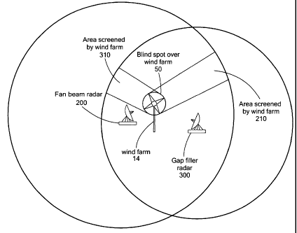
[0027] FIG. 2 shows a system including an airport surveillance radar 100
having a blind
spot 12 due to a wind farm 14. FIG. 3 shows an exemplary system including a
fan beam
airport surveillance radar 200 and a gap filler radar 300 that illuminates a
blind spot 210 in
the airport surveillance radar 200 created by a wind farm 14. In similar way,
the gap filler
4
CA 02759012 2011-10-17
WO 2010/121118 PCT/US2010/031372
radar blind spot 310 is covered by the fan beam airport surveillance radar
200. A blind
spot 50 remains at the wind farm location.
[0028] The blind spot 50 is due to interference resulting from rotations of
the individual
wind turbines that create Doppler frequencies that the radar can detect as
(false) moving
targets. False targets may flood the wind farm area so that the radar
detection mechanism
may not be able to separate an aircraft flying over the wind farm from these
false targets.
[0029] While conventional beam processing can estimate target altitude, false
targets from
the wind farm 14 will have low altitudes. When an aircraft is flying over the
wind farm 14,
the resultant estimated altitude will be somewhere between the actual aircraft
altitude and
the wind farm altitude, as shown in FIG. 4. Using the estimated altitude alone
will not
solve this type of blind spot in all cases. FIG. 4 shows that due to the
limitation of the
concurrent beam processing capability, the estimated plot altitude on the wind
farm is
averaged to about 2,000 ft. When an aircraft flew over the wind farm at 16,000
ft, the
resultant estimated altitude became 7,000 ft.
[0030] In accordance with exemplary embodiments of the invention, merging data
from a
gap filler radar with an airport surveillance radar can mitigate blind spots.
In one
embodiment, a relatively low-cost phased array radar can be used as gap filler
radar with
pencil-beam illumination that can detect aircraft flying over wind farms
without the
interference from the rotating turbines.
[0031] FIG. 5 shows an example scan pattern for pencil beam gap filler radar
skipping
over the wind farm 550. As can be seen, the pencil beams 500 can be directed
to
illuminate the blind spot area while avoiding the wind farm 550.
[0032] Conventional radar systems use a multi-sensor multiple hypothesis
tracker to
merge radar data. However, this approach alone cannot avoid merging false
targets from
the radar data, which can result in degraded performance.
CA 02759012 2011-10-17
WO 2010/121118
PCT/US2010/031372
[0033] In accordance with exemplary embodiments of the invention, the
inventive system
merges targets that have been classified before tracking. In one embodiment
shown in
FIG. 6, each radar has signal processing that includes similar processing. An
airport
surveillance radar 602 can include parallel data paths for a high beam
receiver 604a and a
low beam receiver 604b. The high and low data paths can include respective
Doppler
filtering 606a,b, CFAR detection 608a,b and plot extractor 610a,b. A
classifier 612
coupled to the plot extractors 610a,b provides output data to a multi-sensor
tracker 614
coupled to a display 616. The gap filler radar 620 includes a receiver 622,
doppler filter
624, CFAR detection 626, plot extractor 628, and classifier 630, which
provides data to
the multi-sensor tracker 614.
[0034] In general, features of each detection cluster are calculated in the
plot extractor
610, 628, including altitude and radial velocity estimations. Outputs are then
fed to the
classifier 612, 630 in each radar. The classifiers 612, 630 should be
designated for each
radar since the characteristics of each radar type are unique.
[0035] In one embodiment, the classifiers 612, 630 output the plots with
confidence
factors indicating the plot probabilities. The tracker 614 collects the plots
from the radar
systems 602, 620 and forms tracks under the condition that the plots are
classified as
aircraft with a confidence factor higher than a predefined value (e.g. 0.6).
If a plot is not
classified as aircraft, or as a low confidence aircraft, the plot will be
ignored for that scan,
but may be used for coasting location update.
[0036] With the plots classified before tracking, false plots generated by the
wind farm
will not be treated as aircraft because of the following feature
characteristics;
(1) the altitude estimation is low, (e.g., less than about 4,000 ft from local
ground at
about 10 nmi, and is close, (e.g., about within 0.5 nmi to known wind farm
area);
(2) the estimated radial velocity does not match scan-to-scan movement;
(3) the wide Doppler spectrum, (e.g., spread over a few hundred Hertz), fits
the wind
turbine profile; and/or
(4) the plot is not detected by the pencil-beam gap filler radar.
6
CA 02759012 2011-10-17
WO 2010/121118 PCT/US2010/031372
[0037] In contrast, with the following feature characteristics, the radar plot
of an aircraft
flying over a wind farm will be classified as aircraft and continue to support
the track over
the wind farm:
(1) altitude estimation may drop due to the wind farm interference but is
still higher
than the normal wind farm altitude, (e.g., higher than about 4,000 ft from
local
ground at about 10 nmi); and/or
(2) the plot is detected by the pencil-beam Gap Filler radar and is classified
as aircraft
with high confidence factor (e.g. > 0.6).
[0038] It is understood that the features used in the classifier can be
provided by a variety
of suitable processes and parameters, such as polarimetric characteristics,
altitude
estimation, detection cluster shape and size, and Doppler features. Exemplary
classifier
techniques are disclosed in U.S. Patent No. 6,677,886, filed on Jan 13, 2004,
which is
included herein by reference.
[0039] FIG. 7 shows an exemplary sequence of steps for implementing blind spot
mitigation having target classification in accordance with exemplary
embodiments of the
invention. A target tracker waits in step 701 for new target plots from
multiple radars.
When a new target plot is received, the tracker associates the plot location
to the existing
track files. If the new plot is found to have range and angular location
within the
associated window of a track file, this new plot is assumed to be the new
location of the
track file in step 702. In one embodiment, the gap-filler radar is a three
dimensional radar
and the fan beam radar is equipped with altitude estimation from the high and
low beams,
as described above. In step 704, the system checks the altitude association
and determines
in step 705 if the new plot is within the altitude associated window of a
track file. In step
706, the system checks the target types between the new plot and the
associated track file.
If the associated track file is of the same type as determined in step 707,
the system
updates the track file in step 708 with the new plot location. If any of the
association
process in above failed, the new plot is used for creating a new track in step
709 that
includes target type and altitude.
7
CA 02759012 2011-10-17
WO 2010/121118 PCT/US2010/031372
[0040] When waiting for new plots in step 701 times out, for example, the
system can
examine track files in step 710. If a track file has not been updated for the
period of the
longest scan time of the radars, as determined in step 711, the track file is
updated as
coasting in step 712 using the predicted location. If the track file has been
coasting for N
scans , as determined in step 713, the track file is deleted in step 714.
[0041] Exemplary embodiments of the invention merge multiple asynchronous
radar data,
merge radar data at target classification level, and/or merge radar data
between rotating
fan-beam radars and pencil-beam phase array radars. Use of the classifier
output data
(target type) as one of the track association parameters can significantly
suppress false
tracks and can maintain aircraft tracks over high clutter area.
[0042] Additional classification information is now provided. In general,
method and
apparatus for air clutter detection exploit weather and high/low beam target
channels of a
terminal S-band ASR air traffic control radar, e.g., 2700 MHZ to 2900 MHz, to
create
polarimetric data and altitude estimation. By also utilizing Doppler
information, the
system can classify detections as fixed-wing aircraft, rotary-wing aircraft,
birds, insects,
rain, hail, false alarms due to ground traffic, wind farm induced clutter,
anomalous
propagation induced clutter, and the like. In other embodiments, air clutter
detection is
provided as part of an en-route L-band system.
[0043] Polarimetic signatures can be used to distinguish between aircraft and
birds, for
example. Where a system has a target channel and a weather channel, the
weather channel
is a different polarization from that of the target channel, and the channels
are processed in
separate receiver-signal processor channels. The weather channel provides
precipitation
reflectivity. Using a system processor, the weather channel data is processed
in a similar
manner to the target channel data. The amplitude ratio and phase difference
between the
target and weather channel data can be calculated with the resultant amplitude-
phase
factors providing distinguishing target characteristics. Since the system
includes high and
low beams, the system can be used as in a mono-pulse radar to estimate target
altitude by
simultaneously processing the high and low beam data.
8
CA 02759012 2011-10-17
WO 2010/121118 PCT/US2010/031372
[0044] FIG. 8 shows an exemplary system 800 that can provide blind spot
mitigation by
target classification in accordance with exemplary embodiments of the
invention. A
pedestal 810 includes a motor 812 and encoder 814 coupled to a pedestal
controller 816.
A transmitter 818 is coupled to a rotary joint 820 providing a weather channel
822 and low
beam and high beam target channels 824, 826 to an antenna assembly 828.
[0045] The rotary joint 820 is coupled to a first RF assembly 830 and a second
RF
assembly 840, each having a target low beam module 832, 842, a target high
beam module
834, 844, and a weather module 836, 846. A first receiver/exciter 850 and a
second
receiver/exciter 860 each include down converter modules 852, 854, 856, 862,
864, 866
and local oscillators 858, 868 for the respective low beam, high beam, and
weather
signals. The downconverted signals are provided to first and second signal
processors
870, 880, which are both coupled to first and second radar data processors
882, 884 via
first and second local area networks (LANs) 886, 888, for example.
[0046] The system 800 can include features of air traffic control systems that
have an
independent weather channel and target channel. Weather related false alarms
in the target
channel are typically not suppressed by checking against the detection of
precipitation in
the weather channel. Such weather channel reports are also not processed in
such a manner
as to be able to discern whether the precipitation type is rain, hail or snow.
[0047] The inventive system 800 uses data from both the weather high and low
beam
channels and target high and low beam channels to detect and classify
detections for
mitigating blind spots. The system takes advantage of the different
polarization between
the weather and the target channels to provide polarimetric data. In addition,
the low and
high beam of the target channels provide altitude information. Together with
the Doppler
and reflectivity information, the system 800 is thus capable of classifying
detections and
becomes an integrated detection classification system for air traffic control
use.
[0048] In operation, the signal processor uses the high beam data in the short
pulse range,
e.g., in the order of 0.5 to 6.5 nmi to avoid the ground clutter, and switches
at a predefined
range, e.g., 6.5 nmi, to the low beam for complete altitude coverage.
9
CA 02759012 2014-01-13
[0049] In an exemplary embodiment, the system 800 includes a multi-channel,
e.g., seven,
rotary joint 820 to enable both the high beam data and the low beam data to be
processed
concurrently over the full instrument range. For each detection in the low
beam data, the
system searches for a corresponding detection in the high beam data at the
same range.
The altitude of the detection is estimated using a lookup table with the
target amplitude
ratio between the two beams as one of the indexes and the range as the other.
An
exemplary altitude estimation technique is shown and described by H. R. Ward
in U.S.
Patent No. 4,961,075, The
estimated altitude of
the detection is useful for separating aircraft from false alarms due to
moving clutter, such
as birds, weather, etc., ground traffic and wind farms.
[0050] The system 800 also performs target detection using the weather channel
data.
Since the weather channel data is of a different polarization to the target
channel, the
differential reflectivity, differential phase and correlation coefficient
between the two
polarization data can be calculated. According to D.S. Zrnic, birds and
insects have
differential reflectivity between 2 and 9 dB and differential phase about 25
degrees;
ground clutter has large differential reflectivity but has a zero mean value;
weather has
low differential reflectivity and phase but has high correlation coefficient.
Discrimination
between birds and insects is possible because insects tend to have higher
differential
reflectivity, while birds have higher differential phase.
[0051] FIG. 9 shows an exemplary system 900 having target classification in
accordance
with exemplary embodiments of the invention. The system 900 includes a high
beam
channel 902 and a low beam channel 904 providing data to an altitude
estimation module
906. The altitude estimation module 906 outputs altitude 908 and reflectivity
910
information to statistical classifier module 912.
[0052] The altitude estimation module 906 provides phase information 914 to a
polarimetric data module 916, which receives data from a weather channel
detection
module 918 as well as reflectivity information 910 and phase information 914
from the
altitude estimation module 906. The polarimetric data module 916 provides
differential
CA 02759012 2014-01-13
reflectivity information, differential phase informatiOn, and correlation
coefficient
information to the statistical classifier module 912.
[0053] In general, the polarimetric characteristics are used as detection
features. Together
with the estimated altitude these features are mapped to the statistics of the
known
detection classes, which include aircraft types, weather types, birds, insects
and false
alarm types. These statistics form a multi-dimensional "training database."
During normal
operation, the measured features are mapped to the training database to read
out the
detection classes. The highest class with the highest population is selected
as the result and
the population count is converted to a confidence factor. The confidence
factors over
multiple radar scans are accumulated for the detections and the conferred
results are
reported to the air traffic control display.
[0054] FIG. 10 shows further details 1000 of the system 900 of FIG. 9. For the
low beam
target channel, data is processed by a series of modules including a Doppler
filter module
1004, and log-magnitude calculation module 1006. A CFAR (Constant False Alarm
Rate)
detection module 1008 is coupled to a binary integration module 1010, which
provides an
output to an altitude estimation module 1012. The altitude estimation module
1012 and
altitude database 1014 are described more fully below.
[0055] Binary integration data (peak detection range and filter) is provided
to a log-
magnitude calculation module 1016 for the high beam target channel and to a
module to
calculate polarimetric parameters 1018. The high beam target channel path
includes a
Doppler filter module 1022, which is coupled to the log magnitude calculation
module
1016.
[0056] The low beam weather channel data is processed by a pulse compression
module
1024 and a filter module 1026. A clutter map module 1028, a filter selection
module
1030, and a clear day coefficient selection module 1032 are coupled in
parallel and
exchange information with the filter module 1026. A weather map module 1034
receives
11
CA 02759012 2011-10-17
WO 2010/121118 PCT/US2010/031372
the filtered data and provides a series of outputs to a merge module 1036,
which provides
output data to a weather contour module 1038 coupled to a radar data
processor.
[0057] The module 1018 to calculate polarimetric parameters receives target I
and Q data
from the high beam target pulse compression module 1020 and weather I and Q
data from
the weather channel pulse compression module 1024 and generates phase and
reflectivity
ratio information, as described more fully below. This information is provided
to a
statistical target classifier module 1042, which receives data from a trained
database 1043,
outputting detection range, azimuth, altitude, target type, and confidence
information
provided to an RDP.
[0058] As shown in FIGs. 11 and 11A, the high beam data and low beam data pair
are
extracted along with the Mode-C code. An amplitude ratio for the high and low
beam data
is calculated for a target range to generate an amplitude ratio table at the
altitude given by
the Mode-C code, as shown. In one embodiment, a 3x32 cells operator (32 range
columns
and 3 altitude rows) is used to average the amplitude ratio. The table is then
smoothed
before being used for altitude estimation. FIG. 11A shows the smoothed
amplitude ratio
versus altitude curve for the range of 30 nmi.
[0059] FIG. 12 shows an exemplary sequence of steps for estimating altitude in
accordance with exemplary embodiments of the invention. In step 500, the
amplitude
ratio is determined for a given range from the high beam signal over the low
beam signal.
In step 502, it is determined whether the amplitude ratio is less than a low
threshold value.
If so, no estimation is performed in step 504. If not, then it is determined
in step 506
whether the amplitude ratio is greater than a high threshold. If so, no
altitude estimation is
performed. If not, in step 508, the amplitude ratio is rounded to an index
value. In step
510, an altitude estimation and confidence value are generated from a table,
such as the
table of FIG. 12A, from the range and index values.
[0060] In an exemplary embodiment, the target altitude is estimated at 100
foot intervals
with a confidence factor ranging from 0 to 1. The confidence factor can be pre-
calculated
in the table based on the standard deviation of the altitude value at the
given amplitude
12
CA 02759012 2014-01-13
ratio before smoothing was applied, for example. It is understood that the
granularity of
the altitude estimate can vary to meet the needs of a particular application
and the
information obtainable from the radar system.
[0061] FIG. 12A shows an exemplary plot of amplitude ratio versus altitude at
various
ranges, shown as 10, 20, 30, 40, and 50 nautical miles (nmi) for exemplary
data. It is
understood that the plotted data is smoothed. The approximate threshold
values, AH and
AL, are also shown marking the linear portion of the smoothed data.
[0062] FIG. 13 shows an exemplary sequence of steps for polarimetric parameter
calculation in accordance with exemplary embodiments of the invention. For
given range,
Ic, Qc, co-polarization data, and Ir, Qr reverse polarization data, in step
1300 I and Q data
is selected from the specified range R. In step 1302, the differential
reflectivity ZDR is
(12 Q2 +QT 2..µ
computed as ZDR =10logi0 cc _ 10log,0 ' __ 4 . Differential reflectivity is
further disclosed in U.S. Patent Publication No. 2010/0079328, filed on May 5,
2009.
In step 1304, the differential phase 4)DR is
= tan ---¨ tan
--1 c
computed as ODR
\Qc
[0063] FIG. 14 shows an exemplary sequence of steps for statistical target
classification.
In step 1400, for given range R, estimated altitude Alt, differential
reflectivity ZDR, and
differential phase 4) DR, integer values r,L, iz, and id, are generated in
step 1402 to generate
probability values. More particularly, a probability of the target being an
aircraft Pig is
computed from a table using values tgt, ir, ia, j1,id. In an exemplary
embodiment, the
indexes tgt, wx, bird and cltr represent four separate tables that form the
trained database
filled with measured data from known objects such as aircraft (tgt), weather
(wx), birds
(bird) and ground clutter (cltr). Similarly, a probability of a target being a
weather-related
false alarm is determined from a table based on values for wx, r,L, i-z, id.
The probability
of a target being birds is determined from bird, id and the probability of
a target
being ground clutter related false alarm is determined from cltr, r, a,
13
CA 02759012 2011-10-17
WO 2010/121118 PCT/US2010/031372
[0064] In another embodiment, the amplitude ratio (ZDR) and phase difference
(DR)
between the target and weather channel data can be calculated to distinguish
target
characteristics. As noted above, a DASR system, has a target and a weather
channel. The
weather channel is a different polarization to the target channel, and they
are processed in
separate receiver-signal processor channels.
[0065] The DASR weather channel determines precipitation reflectivity. In an
exemplary
embodiment, the weather channel data is processed in a similar manner to the
target
channel data. This approach provides simultaneous polarimetric data, which is
an
improvement over polarimetric data in alternative radar dwells. The amplitude
ratio (ZDR)
and phase difference (DJ) between the target and weather channel data can be
calculated
as follows:
+ 2"
ZDR 10.1og10 ____
2 (1)
+
tan _I( ( tan
-1
ODIZ (2)
Q,
\QrJ
where R is range, I and Qc are the in-phase and quadrature data of the co-
polarization
channel, and /r and Q, are the in-phase and quadrature data of the reverse
polarization
channel.
[0066] It should be noted that while some systems, such as current ASR systems
use a dual
fan beam, they do not provide target altitude without associated beacon data.
Since a DASR
has both high and low beams, these beams can be processed simultaneously in a
similar
manner as in a mono-pulse radar to estimate target altitude.
[0067] Actual data was recorded for simultaneous polarimetric data. FIG. 15
shows an
example of estimated target altitude in comparison with the target altitude
from the beacon
radar. The altitude estimations (dots) have deviation from the beacon radar
reported
altitude (Mode C ode). Smoothing the altitude estimations over 13 scans, for
example,
14
CA 02759012 2014-01-13
provides a more accurate estimation of the target altitude. In this case the
RMS error is
240 ft.
[0068] FIG 16 shows the distinct features of an aircraft and FIG. 17 shows
possible bird
data expressed in amplitude ratio versus phase difference maps based upon
collected data.
FIG. 16 shows the peak of the distribution at 0 degree phase difference and 6
dB
amplitude ratio. The bird data in FIG. 17 has a peak of the distribution at 30
degrees phase
difference and 9 dB amplitude ratio. It should be noted that the distribution
in FIG. 17 has
wider spread than FIG. 16.
[0069] It is understood that a variety of polarizations can be used in various
embodiments.
Exemplary polarizations include linear polarization (transmission in vertical
polarization,
channel A received in elliptical polarization, channel B received in vertical
polarization),
circular polarization (transmission in circular polarization, channel A
received in circular
co-polarization, and channel B received in circular reverse polarization). As
noted above,
circular polarimetric data shows clear differences between channels and target
types. It is
understood that further polarization configurations are possible.
[0070] Having described exemplary embodiments of the invention, it will now
become
apparent to one of ordinary skill in the art that other embodiments
incorporating their
concepts may also be used. The embodiments contained herein should not be
limited to
disclosed embodiments but rather should be limited only by the scope of the
appended claims. All publications and references cited herein are expressly
incorporated
herein by reference in their entirety.
What is claimed is: