Note: Descriptions are shown in the official language in which they were submitted.
CA 02761070 2011-11-04
WO 2010/117959 PCT/US2010/029991
SYSTEM FOR DRAPING METEOROLOGICAL DATA ON A THREE
DIMENSIONAL TERRAIN IMAGE
CROSS-REFERENCE TO RELATED APPLICATIONS
[0001] This application claims priority from U.S. Provisional Patent
Application No.
61/166,761 titled "SYSTEM FOR DRAPING METEOROLOGICAL DATA ON A
THREE DIMENSIONAL TERRAIN IMAGE" that was filed on 04/05/2009.
FIELD OF THE INVENTION
[0002] The invention relates generally to weather radar displays. More
specifically, the
invention relates to a system of layering weather data over a three
dimensional terrain
image.
BACKGROUND ART
[0003] Weather broadcasts are some of the most highly rated features of news
broadcasts. As competition for viewers increases, it is important to stations
to put forth a
weather broadcast that presents meteorological data in attractive and
informative format.
Presently, most weather displays on a broadcast present data, such as radar
displays, in a
two-dimensional (2D) format. The 2D displays are common and can be boring.
Consequently, a three dimensional (3D) display would be greatly desired since
it would
be able to bring dramatic and informative displays of weather data to the
viewer.
SUMMARY OF THE INVENTION
[0004] In some aspects, the invention relates to a system for draping
meteorological data
on a three dimensional terrain image, comprising: a central processing server
configured
to receive meteorological data in real time and drape the meteorological data
over a
previously designated three dimensional terrain image; and a display computer
that
1
CA 02761070 2011-11-04
WO 2010/117959 PCT/US2010/029991
receives a data transmission of the meteorological data draped over the three
dimensional
terrain image.
[0005] In other aspects, the invention relates to a system for draping
meteorological data
on a three dimensional terrain image, comprising: means for receiving multiple
streams
of meteorological data in real time; means for draping the streams of
meteorological data
over a previously designated three dimensional terrain image; and means for
transmitting
the meteorological data draped over a three dimensional terrain image to an
end user.
[0006] In other aspects, the invention relates to a method for draping
meteorological data
on a three dimensional terrain image, comprising: step for receiving multiple
streams of
meteorological data in real time at a central processing server; step for the
streams of
meteorological data over a previously designated three dimensional terrain
image at the
central processing server; and step for transmitting the meteorological data
draped over a
three dimensional terrain image to an end user's display computer.
[0007] Other aspects and advantages of the invention will be apparent from the
following
description and the appended claims.
BRIEF DESCRIPTION OF DRAWINGS
[0008] It should be noted that identical features in different drawings are
shown with the
same reference numeral.
[0009] Figure 1 shows an example of three dimensional image of mountainous
terrain.
[0010] Figure 2 shows an example of meteorological radar images draped on a
three
dimensional terrain image in accordance with an embodiment of the present
invention.
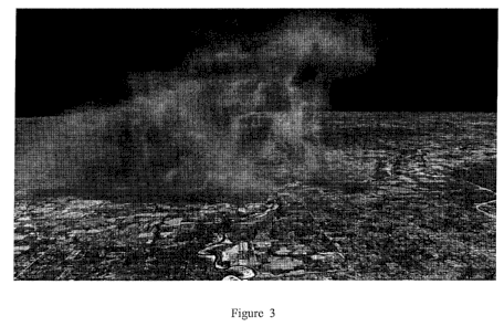
[0011] Figure 3 shows an example of a three dimensional thunder storm image
draped on
a three dimensional terrain image in accordance with an embodiment of the
present
invention.
[0012] Figure 4 shows an example of a three dimensional thermometer image
draped on
a three dimensional terrain image in accordance with an embodiment of the
present
invention.
2
CA 02761070 2011-11-04
WO 2010/117959 PCT/US2010/029991
DETAILED DESCRIPTION
[0013] A system and method for draping meteorological data on a three
dimensional (3D)
terrain image has been developed. The system can also render 3D graphics of
live radar
data and deliver lifelike models of terrain and landmarks around the world,
Figure 1
shows an example of such a three dimensional image of mountainous terrain.
[0014] The system also contains high-definition (HD) data products, aerial
mapping,
nationwide and worldwide topography, ocean depth mapping, political
boundaries, and
an earth halo effect in a completely renderless display. In one example, the
3D modeling
can add local landmarks such as sports stadiums and include on-site anemometer
data to
show the current winds.
[00151 The 3D modeling overlay can also incorporate radar data from additional
radar
stations into a 3D composite display. In one example, the system can instantly
render 3D
graphics of satellite and radar data from multiple sources to show a hurricane
forming off
the coast of Africa that might make its way to Florida, The present invention
has been
able to integrate live data from up to 20 sources at one time. Figure 2 shows
an example
of meteorological radar images draped on a three dimensional terrain image.
[0016] The system includes software that is loaded and stored at a
broadcaster's facilities
with data provided from the U.S. Weather Service and other radar and satellite
sources.
The data may be transmitted via the Internet. The basic system features and
functionality
include:
= a 720p/1080i High Definition (HD) display;
= integration of HD weather data and high resolution true-to-life worldwide
aerial
mapping and terrain in a no-render system which provides the ability to take
viewers on true HD weather flights both locally and worldwide;
3
CA 02761070 2011-11-04
WO 2010/117959 PCT/US2010/029991
= 3D model integration including actual 3D cityscapes and 3D objects (some of
which can be driven by actual weather data) which can be incorporated into the
weathercast for a unique visual style;
= live sensor integration offering unique visualization of real-time weather
data;
= HD data delivered directly in an auto-updating environment and providing the
flexibility to display multiple products simultaneously from multiple sites
with
extensive lapsing;
= data integration allowing the user to display multiple unique data products;
= an easy to use graphical user interface that allows for system set-up, show
set-up,
and show playback from a single frame to a complete sequence; and
= a "sketch" application providing the ability to create a complete weather
show,
including: complete banner and logo support, text overlays, graphic pages,
auto-
updated forecast and current conditions pages, live video and video on file
integration.
[0017] The types and classes of data supported by the system include: Live
station radar;
Reflectivity; Velocity; De-aliased Velocity; Storm Relative Velocity; Shear;
Echo Tops;
VIL; VIL Density; Precipitation Rate; Precipitation Accumulation (1, 3, 12, 24
hour
rain/snow/mix accumulation); Heavy Rain; Snow Machine; and Heavy Snow. Other
types of data include: Composite U.S. Reflectivity (Level 2 (2km) and Level 3
(1km));
Composite Level 3 U.S. radar data (24 hour accumulation, VIL Density, and Echo
Tops);
Satellite Products (10km Worldwide Satellite, 4 km IR, 4km Visible, 16km WV,
4km
Ch4 - Ch2 Fog Satellite imagery, and 1km Visible for select sectors); Whole
U.S. raster
products (Current temperature, Current dew point temperature, Current wind
speed,
Current humidity, Current heat index, Current wind chill, and 24 hour max min
and
4
CA 02761070 2011-11-04
WO 2010/117959 PCT/US2010/029991
change in temperature); Lightning; Metar observations; NDFD Forecast data; 1
km / 256
color Snow Cover. Also, various nautical, environmental and other data is
supported,
including: Local Storm Reports; Buoys; Earthquakes; Fire; Airport Delays; Air
Quality
(AQI and Ozone); Hurricane Products (Position, Track, Cone, Spaghetti plots,
Wind
probabilities, Wave Height, and Storm Surge), River Stage Information, and
Worldwide
Forecasts.
[0018] The system can also support video provided by Internet Based Webcams;
Animation encoded MOV files; MPEG files; a data from sensor networks such as
FAWN. The system may also support and incorporate Numerical Model data from:
RUC; GFS; NAM; BAMS; and a special 3km BAMS model.
[0019] The present invention may display anemometers, thermometers, buoys,
river
gauges, road sensors, and snow sticks. Each of these items responds in real
time directly
to currently observed conditions as shown in Figure 4. Additional tropical
features are
also available including the forecast cone, past position, sketch integration
with tropical
advisory information, spaghetti models as well as additional data products
(SLOSH,
Surface Wind Forecast, Tropical Wind Probability, Tropical Wave Height,
Tropical
Storm Surge Probability, HWRF model, Coastal Watches/Warnings).
[0020] Some embodiments of the present invention utilize 64-bit Architecture
for the
system. When combined with a volumetric imager and GPS integration, the
present
invention has the ability to take a volume scan and in real time, create a 3
dimensional
image of reflectivity. This allows viewing of a complete three dimensional
storm
structure as well as highlight areas of interest. The lighter areas of
reflectivity can be
edited out to see inside the storm and pick out areas of hail, or forming
tornados as shown
in Figure 3.
[0021] The present invention has the capability of draping real time
meteorological and
related data over a three dimensional terrain depiction. The draped data can
be obtained
from various sources such as satellite data, radar, or over the internet. The
data may be in
various formats such as ASCII, NIDS, or other formats desired by the end user.
In one
embodiment of the present invention, the desired meteorological and related
data are
CA 02761070 2011-11-04
WO 2010/117959 PCT/US2010/029991
simultaneously collected in various formats by a central processing server.
The server
then arranges the data in a fixed format previously designated by the end
user. The data
is arranged and draped over a designated three dimensional terrain image
designated by
the end user. The draped data is then transmitted to the end user for their
use. The data
may be transmitted via the Internet, satellite, or other suitable data
transmission path.
[0022] In one embodiment, the draped data is transmitted in XML format, The
end user
may adjust the types of data and the terrain images as needed. In some
embodiments, the
these adjustments are made by the end user upon receiving the draped data
stream. In
other embodiments, the adjustments are made at the central processing server.
[0023] It should be clear to one of ordinary skill in the art that the present
invention has
the advantage over the prior art of combining true 3-D models, terrain and
data-driven
meteorological animations into a real-time HD environment. While the invention
has
been described with respect to a limited number of embodiments, those skilled
in the art,
having benefit of this disclosure, will appreciate that other embodiments can
be devised
which do not depart from the scope of the invention as disclosed here.
Accordingly, the
scope of the invention should be limited only by the attached claims.
6