Note: Descriptions are shown in the official language in which they were submitted.
CA 02762648 2011-11-18
WO 2010/132986 PCT/CA2010/000745
METHOD, APPARATUS AND SYSTEM
FOR IMPROVED GROUNDWATER MODELING
CROSS-REFERENCE TO RELATED APPLICATIONS
100011 This application claims benefit of U.S. Provisional Patent Application
Numbers 61/179240 filed on May 18, 2009 and 61/179696 filed on May 19,
2009, with attorney docket number 105.0009 and entitled "Method, Apparatus
and System for Improved Groundwater Modeling," both of which are hereby
incorporated herein by reference in their entirety.
BACKGROUND
[00021 The subject matter disclosed in this specification relates to methods
and
systems for use in groundwater modeling, and, in particular, relates to
methods, apparatus, and systems for more effectively and efficiently modeling
groundwater for better aquifer management.
[00031 The groundwater modeler has to deal with different types of
uncertainties,
in particular with parameter uncertainties (Hill, 2007, Doherty 2007) and
conceptualization uncertainties (Poeter, 2006). In order to handle
conceptualization uncertainty, the modeler needs to create a reasonable set of
different alternative conceptual models. This in turn, produces a demand for
the software giving the modeler a tool for developing such conceptualizations.
Currently the cost of developing such alternative models is usually so
prohibitive that the majority of the projects can only afford to explore the
effects of parameter uncertainties.
[00041 The groundwater model development is inherently very complex and
comprises of a number of tasks that requires the hydrogeologist to use a vast
variety of tools. One of the main challenges for the graphical user interfaces
and visualization software is to organize the tools and provide an intuitive
workflow for the model development from raw data to the numerical model.
Sometimes, even though the appropriate tools are available, the modeler is
getting lost trying to navigate to the right tool at the right time.
1
CA 02762648 2011-11-18
WO 2010/132986 PCT/CA2010/000745
[00051 Another challenge is that raw data is usually handled outside of the
model
building workflow. Workflows for creating groundwater-meaningful objects
from the raw data are usually left beyond the graphical user interfaces for
simulation software, which makes it difficult to trace the final model to the
original data.
SUMMARY
[00061 One aspect of the present invention involves a method of groundwater
modeling including collecting, inputting, organizing and managing raw data
concerning an aquifer in a data workspace; developing a conceptual
groundwater model, by creating a structural sub-model, a property sub-model
and a boundary condition sub-model; using the conceptual groundwater
model in a simulation; converting conceptual groundwater model into a
numerical groundwater model having one or more grid types; and running
simulation and analyzing the results. Simulation results can be used to
identify steps to improve aquifer management.
[00071 A further aspect of the present invention involves an apparatus for
modeling a groundwater aquifer comprising: a data workspace having data in
the form of one or more objects, each object having a geometry and at least
one attribute attached to the geometry; a coordinate system for use in editing
the objects; a conceptual model workspace having one or more conceptual
model objects in one or more folders, the conceptual objects having been
created from the data objects though one or more operations; a conceptual
model created from conceptual objects, having a structural sub-model, a
property sub-model and a boundary condition sub-model; an editor for editing
objects in the data workspace to create the conceptual model objects for the
conceptual data workspace; a multi-dimensional viewer to view objects in the
data workspace and to view conceptual model objects in the conceptual model
workspace; and a simulation model having one or more grid types, the
simulation model created from the conceptual model by adding a simulation
domain and one or more grid types.
2
CA 02762648 2011-11-18
WO 2010/132986 PCT/CA2010/000745
[0008] A further aspect of the present invention involves a system for
building a
aquifer model comprising: one or more sources of raw data concerning the
aquifer; a conceptual model builder having a data workspace for importing the
raw data from the one or more sources of raw data, the raw data taking the
form of one or more objects, each object having a geometry and at least one
attribute attached to the geometry; a coordinate system for use in editing the
objects; a conceptual model workspace having one or more conceptual model
objects in one or more folders, the conceptual objects having been created
from the data objects through one or more operations; a conceptual model
created from conceptual objects, having a structural sub-model, a property
sub-model and a boundary condition sub-model; an editor for editing objects
in the data workspace to create the conceptual model objects for the
conceptual data workspace; a multi-dimensional viewer to view objects in the
data workspace and to view conceptual model objects in the conceptual model
workspace; a simulation model having one or more grid types, the simulation
model created from the conceptual model by adding a simulation domain and
one or more grid types; one or more numerical models translated from the
simulation model; and a simulator for running the numerical models.
[0009] A further aspect of the present invention involves a program storage
device readable by a machine tangibly embodying a program of instructions
executable by the machine to perform method steps for groundwater
modeling, said method steps comprising: inputting, organizing and managing
collected raw data concerning an aquifer in a data workspace as objects;
creating conceptual model objects in a conceptual model workspace from the
objects though one or more operations; developing a conceptual groundwater
model from the conceptual model objects, by creating a structural sub-model,
a property sub-model and a boundary condition sub-model; using the
conceptual groundwater model to define a set of one or more simulation
models; converting the one or more simulation models into one or more
numerical groundwater models having one or more grid types; and running a
simulation and analyzing the results.
3
CA 02762648 2011-11-18
WO 2010/132986 PCT/CA2010/000745
[00010] A further aspect of the present invention involves a system for
modeling
groundwater comprising a processor, a data storage system, at least one input
device, and at least one output device, a computer-readable media for storing
data, the system comprising: a data workspace for imported raw data collected
from one or more sources of raw data, the raw data taking the form of one or
more objects, each object having a geometry and at least one attribute
attached
to the geometry; a coordinate system for use in editing the objects; a
conceptual model workspace having one or more conceptual model objects in
one or more folders, the conceptual objects having been created from the data
objects though one or more operations; a conceptual model created from
conceptual objects, having a structural sub-model, a property sub-model and a
boundary condition sub-model; an editor for editing objects in the data
workspace to create the conceptual model objects for the conceptual data
workspace; a multi-dimensional viewer to view objects in the data workspace
and to view conceptual model objects in the conceptual model workspace; and
a simulation model having one or more grid types, the simulation model
created from the conceptual model by adding a simulation domain and one or
more grid types; one or more numerical models translated from the
simulation model; and a simulator for running the numerical models.
[00011] Other objects, features and advantages of the present invention will
become apparent to those of skill in art by reference to the figures, the
description that follows and the claims.
BRIEF DESCRIPTION OF THE DRAWINGS
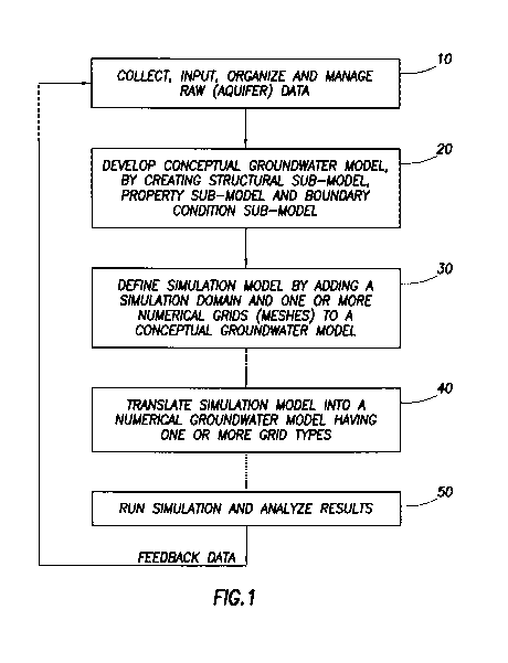
[00012] Figure 1 is a flowchart of an embodiment of the present invention.
[00013] Figure 2 is block diagram of an embodiment of the present invention.
[00014] Figure 3 is a depiction of feature zonation as in an embodiment of the
present invention.
[00015] Figure 4 depicts horizon types as in an embodiment of the present
invention.
4
CA 02762648 2011-11-18
WO 2010/132986 PCT/CA2010/000745
[000161 Figure 5 depicts multiple numerical models (e.g., MODFLOW,
FEFLOW), having different grid types, translated from the same conceptual
model as in an embodiment of the present invention.
1000171 Figure 6 is a simplified depiction of an underground aquifer
intersected by
a monitoring well having a sensor system for collecting raw data as in an
embodiment of the present invention.
[000181 Figure 7 depicts a computer system and a hard disk, in accordance with
an
embodiment of the present invention.
DETAILED DESCRIPTION
[000191 In the following detailed description of a preferred embodiment and
other
embodiments of the invention, reference is made to the accompanying
drawings. It is to be understood that those of skill in the art will readily
see
other embodiments and changes may be made without departing from the
scope of the invention.
[000201 This specification discloses a software application, called a `Hydro
GeoBuilder (HGB)' which functions as a Conceptual Model Builder (CMB),
that provides visual 3D tools for developing a `conceptual model' of a
groundwater study. Hereinafter, the `Hydro GeoBuilder (HGB)' software
application will be referred to as either the `HGB software application' or as
the `HGB'. The conceptual model is grid and simulator independent. The
conceptual model can be translated to different numerical models, such as
USGS MODFLOW, finite element (for instance, FEFLOW), and finite
volume groundwater models (for example see Figure 5). During translation,
the conceptual model is converted to a numerical model input file format,
which can be opened by a numerical model preprocessor, such as SWS Visual
MODFLOW or WASY FEFLOW, or executed directly by the corresponding
engine, such as (but not limited to) USGS MODFLOW. The translation from
conceptual model to simulation model to numerical model may be fully
automated, thus reducing potential for user error, and provides a number of
;5
CA 02762648 2011-11-18
WO 2010/132986 PCT/CA2010/000745
QA/QC (quality assurance, quality control) validations which might not be
possible if done manually.
[000211 The HGB software application disclosed herein implements a concept of
multiple local models developed in the context of a single regional model thus
providing strong parent-daughter relation between the models.
[000221 The numerical grid is not considered to be a part of the conceptual
model
thus facilitating quick and easy re-generating of the numerical model files
using different discretizations. This is different from other numerical model
pre-processors where the numerical grid is introduced at the early stages of
the
model development and input parameters are assigned directly to the
numerical grid mesh elements. Although being independent of the
conceptual model, the numerical grid can take into account conceptual model
elements.
[000231 Boundary conditions for the simulator are considered as grid-
independent
objects thus making provisions for utilizing various models to simulate
boundary conditions behavior ranging from simple analytical to complex
numerical surface water models. In order to unify their behavior and
facilitate
conceptual to numerical model translation, these models are exposed via
OpenMI compliant interface, which prior to releasing this software, has only
been used for linking numerical engines.
[000241 Referring to Figure 1, the HGB software application disclosed herein
focuses on arranging the building of the model into a natural workflow from
Data Processing => Conceptual Model => Simulation Model => Numerical
Model => Simulation => Analysis of Results as depicted in Figure 1. The
simulation related part of workflow is taken care of by commercially available
programs such as Visual MODFLOW. When the simulation is performed, the
results (heads, concentrations, etc.) can be analyzed in Visual MODFLOW or
brought back into the Conceptual Model Builder for further analysis.
[000251 Figure 1 is a flowchart for an embodiment of the HGB software
application disclosed in this specification. One of the first steps in
6
CA 02762648 2011-11-18
WO 2010/132986 PCT/CA2010/000745
developing a groundwater model is to collect the necessary data, and build a
conceptual model. This is depicted as step 10 of Figure 1. The next step is to
develop a conceptual groundwater model (also called herein "conceptual
model"), depicted as step 20 of Figure 1, The conceptual model is an
interpretation of the major processes occurring in the aquifer; this includes
the
soil properties, groundwater flow directions, the geology, wells, and
influence
of rivers and lakes, etc. It is a challenge to maintain, analyze, and
visualize
these typically multi-dimensional data, which originate from a number of
sources in various file formats. Outside of the present invention, this
process
generally requires the use of multiple tools taking care of different aspects
of
the task.
[000261 Once the conceptual model is created, the modeler needs to convert it
to a
particular numerical model, which is another challenging task, especially
when a number of scenarios need to be investigated in order to ensure model
credibility.
[000271 Referring to Figures 1 and 2, in step 10 of Figure 1, raw data
concerning
the aquifer is collected, imported, organized and managed. As depicted in
Figure 2, the HGB software application (which functions as a Conceptual
Model Builder or CMB) provides an `HGB Data Workspace' (or `data
workspace') for organizing and management of the raw data. The object
complexity ranges from rather simple ones such as points, polylines, polygons
and surfaces to as complex as wells (vertical, deviated, or horizontal), or
vertical cross-sections. The objects share a common characteristic: they are
not required to carry any hydrogeological semantics. As depicted in Figure 2,
the objects at this level are considered to be just pure geometry with
attached
attributes having little or no semantics with respect the modeling goal. In an
embodiment of the present invention, the HGB software application allows
the modeler to load the raw data in the context of the modeling project into
the
data workspace and organize the data for future use depending on the
modeling objectives. At all times the raw data stored in the objects are left
intact and kept grid-independent.
7
CA 02762648 2011-11-18
WO 2010/132986 PCT/CA2010/000745
[00028] Referring to Figure 6, this Figure 6 is a simplified drawing of an
aquifer
below ground level, intersected by a monitoring well having a sensor system.
Sensors systems, such as the Schlumberger Westbay System, may record
pressure, temperature, provide pressure profiles or even permit fluid
sampling.
In Figure 1, this is one method that may be used to collect the `raw (aquifer)
data' (refer to step 10 of Figure 1).
[00029] In Figure 2, the objects can be imported from a variety of data
sources
such as Digital Elevation Models (DEM), shapefiles, spreadsheets, databases,
or created manually. The list of supported formats is open and can be
extended as necessary. To facilitate import of geographical information, the
HGB supports a number of geographic (NAD27, NAD83, WGS72, WGS84)
and projected (UTM NAD27, UTM NAD83, UTM WGS84 North, UTM
WGS72 North, SPCS27, SPCS83) coordinate systems and transformations
between them. User-defined non-earth coordinate systems are also supported.
[00030] Although the objects may not be used directly in the numerical model,
they serve as its building blocks. To facilitate this, each object exposes a
set of
operations to change its own state or generate other objects. Possible
examples
of operations includes creating surfaces from points using various
interpolation methods, spatial transformation like shifting and rotating,
converting points to polylines, etc. Operations may include another object as
operands, for instance it is possible to drape a polygon on a surface. To
facilitate traceability of the model, each object carries with it a revision
history: the creation date and the author of the object, what other data were
used, and what operations were applied to it. Operations are typically used in
the data management workflows to "massage" raw data in order to make them
as "close" to conceptual model object as possible. This would typically take
place in step 10 of Figure 1. For instance, information on geological
formations often comes in form of points or cross-section objects, while
conceptual model requires surfaces as the input for applying business rules
based on horizon types. Point and cross-section data objects are converted to
,8
CA 02762648 2011-11-18
WO 2010/132986 PCT/CA2010/000745
surfaces via interpolation operations to serve as input to creating horizon
workflows for structural modeling.
[000311 An embodiment disclosed herein makes use of plug-in based architecture
and allows adding more data objects with required functionality as necessary.
Adding a new data object does not require recompiling the whole application
- the new data objects are preferably deployed in the form of Net assemblies.
Each such Net assembly is accompanied by a manifest that allows the HGB
to discover and load them into the project data workspace dynamically. The
set of consistent programmatic interfaces facilitates using the objects as the
operands for the operations.
[000321 Another feature of the HGB is a set of `2D and 3D viewers and
editors', as
shown in Figure 2. Rather than limit the user to a set of fixed views of the
model being developed, the HGB introduces a concept of universal viewers
and editors. Any object created in the project workspace can be visualized
provided it exposes a set of pre-defined programmatic interfaces. The modeler
can display a number of 2D and 3D views and have different objects
simultaneously visualized in those views. The editing process includes
geometry editing and attributes editing. Geometry editing can be performed
concurrently in a graphical or tabular view thus allowing for increased level
of
control on the object geometry changes. If the object being edited is
simultaneously visualized in other graphical views, all the changes are
reflected live in those views during the editing session. To increase
usability
all editing includes multi-level undo capabilities.
[000331 Referring to Figure 3, attribute editing is based on a selector
mechanism
that allows the modeler to delineate zones in data objects where attributes of
the object's geometrical elements can be specified in a uniform way. Figure 3
shows a simple example, where lines imported from a shapefile were
delineated in a number of zones and used for assigning a river boundary
condition. Each zone is assigned a particular method for defining attributes.
There are a number of methods that can be used to define the attributes:
9
CA 02762648 2011-11-18
WO 2010/132986 PCT/CA2010/000745
constant value, linear interpolation between nodes, values from a surface data
object (imported from DEM), values from a set of river gauge stations, etc.
Once again, the modeler can make use of data objects loaded into the data
workspace - for instance assign river stage from a DEM imported during the
course of data management activity. This mechanism is similar to the one
used in Visual MODFLOW (Chmakov, 2003) to handle the MODFLOW
Stream Routing Package (STR) (Prudic, 1989). Although the example
presented in Figure 3 is one dimensional, the zone based approach for
assigning and editing the attributes does not depend on the object dimension,
and is similarly used for attributes of 2D and 3D objects. This mechanism is
used for defining both property and boundary condition attributes.
[00034] Referring again to Figure 2, the Conceptual Model in the HGB software
application is represented by a `Conceptual Model workspace' or `CM
workspace' or `Conceptual Workspace' that is separate from that of the `HGB
Data Workspace'. Similar to the `HGB Data Workspace', the content of the
`Conceptual Model Workspace' is comprised of objects. The difference
between the objects in the conceptual model ("conceptual model objects" or
"CM objects") and the objects in the HGB Data Workspace is that conceptual
model objects must have particular semantics and adhere to business rules
specific to the conceptual model objects. The Conceptual Model (CM)
workspace contains a fixed structure of folders for organizing the CM objects.
In contrast to the HGB Data Workspace, there is no option to have arbitrary
objects in the conceptual model - the CM structure is fixed and the modeler
typically builds CM objects using data objects as building blocks. The
modeler can create as many conceptual models as (s)he wants, using objects
from data workspace.
[00035] Referring to Figure 4, in an embodiment of the HGB software
application
disclosed herein, each conceptual model is comprised of three sub-models:
Structural Model, Property Model, and Boundary Condition Model, each one
with its own (fixed) structure. Accordingly, as depicted in step 20 in Figure
1,
the CM creation workflow includes creating these models in succession. The
CA 02762648 2011-11-18
WO 2010/132986 PCT/CA2010/000745
Structural Model (SM) consists of a bounding polygon and a set of horizons;
the horizons represent the geological structure of the site. Typical SM
creation
workflow assumes creating horizons from surfaces existing in the data
workspace (surfaces can be imported or created from 2D-XY scatter points,
cross-section interpretations, or well tops). In Figure 4, at this step, the
HGB
enforces business rules for different types of horizons (base, erosional,
conformable, and discontinuous as shown in Figure 4) by properly modifying
the original surfaces used for horizon creation. The horizons used in the
present invention are preferably those used in the commercially available
PETREL software, available from Schlumberger. The volumes in between
the horizons constitute the structural zones used later on for property
modeling.
[00036] Referring to Figure 5, this Figure 5 depicts multiple numerical models
(e.g., MODFLOW, FEFLOW), having different grid types, translated from the
same conceptual model. At the next step, the property zones are created using
structural zones as the compartmental basis; the modeler has an option to
further subdivide the compartment structure provided by the structural model
using data objects such as polygons and surfaces in order to create more
property zones. Based on these property zones the modeler assigns property
attributes required by the modeling objectives. The most complex part of
conceptual modeling is defining the Boundary Conditions (BC). In essence,
these are independent models ranging from relatively simple ones that are
incorporated in the main simulator (for example River BC in MODFLOW) to
rather complex models like MIKE 11 (Havno et al, 1995) providing very
detailed model for channel flow. In both cases, however, the external models
share the same geometry (river network) but require a different set of model
attributes. In the first case (MODFLOW River BC), it is sufficient to specify
just a few attributes; in the second case (MIKE 11) there is a complex
workflow defining the model which is linked together through OpenMI
interface. On the HGB side, however, specifying MIKE 11 as the BC model
of choice is rather simple - the modeler should just specify a path to the omi
II
CA 02762648 2011-11-18
WO 2010/132986 PCT/CA2010/000745
manifest of the respective MIKE 11 project (Graham, Chmakov et al., 2006).
A simplified linking, where boundary conditions for the numeric model are
taken from another model - numerical or analytical - can also be handled this
way. On the conceptual level a numerical model is represented by its
simulation domain. In step 30 of Figure 1 a simulation model is defined by
adding a simulation domain and one or more numerical grids (meshes) to a
conceptual model. There can be more than one simulation domain for every
conceptual model, thus providing a method to generate a regional-local
relationship between the numerical models and facilitate scenarios with local
grid refinement. Each simulation domain can have one or more numerical
grids attached to it, which defines the horizontal discretization. The grid
(mesh), though not linked to the conceptual model, is defined in this
workspace only at the time of translating the conceptual model to the
numerical model. It is important to emphasize, that in the contrast to the
conventional approach, the numerical grid/mesh is not used as the definition
domain for the model properties - it only serves as one of the inputs to the
process of translating a conceptual model to the simulation model and then to
a numerical model. In Figure 5, if the project objectives change, a new
numerical model can be easily generated (Figure 5), or existing ones updated,
from the conceptual objects. This way the modeler can explore different
modeling scenarios by changing discretizations, boundary conditions or,
ultimately, even switch to another main simulator (MODFLOW, FEFLOW,
ECLIPSE, analytical models, etc.). Including numerical grid/mesh into
conceptual model to form a simulation model allows one to establish a link
between the conceptual model and the resulting numerical model(s) and
simplifies the process of bringing the simulation result back into the
Conceptual Model Builder.
[00037] In Figure 1, in step 40 of Figure 1, the simulation model is
translated into
a numerical groundwater model having one or more grid types. At that point,
a simulation may be run (step 50 of Figure 1) and the results analyzed. The
12
CA 02762648 2011-11-18
WO 2010/132986 PCT/CA2010/000745
results may be compared to aquifer performance and may lead to steps to
better manage the aquifer. The results may also be fed back into the process.
[00038] Referring to Figure 7, a computer system 100 and a hard disk 122
according with a preferred embodiment of the present invention is illustrated.
The computer system 100 includes a processor 105 connected to a system bus
108, a display device 110 connected to the system bus 108, and a memory or
program storage device 115 connected to the system bus 108. The display
device 110 is adapted for display of output, such as visualizations of objects
or
conceptual model objects as previously described. In accordance with an
embodiment of the HGB software application disclosed herein, the memory or
program storage device 115 is adapted to store a software in accordance with
the present invention, such as the Hydro GeoBuilder (HGB) U software 120 (or
HGB software 120), or other embodiments of the HGB software 120 of the
present invention. The Hydro GeoBuilder (HGB) software 120 (or HGB
software 120) is preferably originally stored on a hard disk 122 or other
program storage device; however, in Figure 7, the hard disk 122 was
previously inserted into a reader (not depicted in Figure 7) of the computer
system 100 and the HGB software 120 was loaded from the hard disk 122 into
the memory or program storage device 115 of the computer system 100 of
Figure 7. The HGB software 120 contains programming sufficient to perform
the steps depicted in Fig. 1 (or other steps in accordance with other
embodiments of the software application disclosed herein). Simulation
software 121 which uses output of the HGB software 120 to run simulations is
also depicted in Figure 7. In addition, input data (not depicted) is adapted
to
be sent to the system bus 108 of the computer system either via an input
device 138 or a storage medium 130 adapted to be connected to the system
bus 108.
[00039] In operation, the processor 105 of the computer system 100 will
execute
the Hydro GeoBuilder (HGB) software 120 stored in the memory or program
storage device 115 of the computer system 100 while, simultaneously, using
the input data (from the input device 138 or stored in the storage medium 130
13
CA 02762648 2011-11-18
WO 2010/132986 PCT/CA2010/000745
during that execution). When the processor 105 executes the Hydro
GeoBuilder (HGB) software 120 stored in the memory or program storage
device 115 (while using the input data), output data (not depicted) is sent to
the display device 110, which will record or display visualizations such as
that
of objects, conceptual model objects or groundwater models. Output data
may also be sent to the simulation software 121 to be used for running
simulations. Output from the simulations may be used as input for the Hydro
GeoBuilder (HGB) software 120.
[000401 The display device 110 may include a display screen of the computer
system 100, and/or may include a printer to produce printouts generated by
the computer system 100. The computer system 100 may be, for example, a
personal computer. The memory or program storage device 115 may be a
computer readable medium or a program storage device which is readable by
a machine, such as the processor 105. The processor 105 may include, for
example, a microprocessor, microcontroller, or a mainframe or workstation
processor. The memory or program storage device 115 may be, for example, a
hard disk, ROM, CD-ROM, DRAM, or other RAM, flash memory, magnetic
storage, optical storage, registers, or other volatile and/or non-volatile
memory.
[000411 Although the foregoing is provided for purposes of illustrating,
explaining
and describing certain embodiments of the invention in particular detail,
modifications and adaptations to the described methods, systems and other
embodiments will be apparent to those skilled in the art and may be made
without departing from the scope or spirit of the invention.
14