Note: Descriptions are shown in the official language in which they were submitted.
CA 02765546 2015-06-11
MULTI-MODE ELECTROMAGNETIC SURVEYING
FIELD OF THE INVENTION
[0001] The invention relates to the use of induced and naturally-occurring
signal modes to
obtain information about subsurface formation. More specifically, the
invention relates to
multi-mode electromagnetic data collection and interpretation.
[0002]
BACKGROUND OF THE INVENTION
[0003] Electromagnetic surveying of subsurface formations typically entails
the use of either
electric or galvanic sources and either electric or galvanic receivers,
depending on the nature
of the formation.
[0004] Galvanic sources are coupled via electric/galvanic contacts or "poles"
into the earth;
in a dipole source, an electric current flows between two contacts through the
subsurface.
Galvanic receivers are coupled via electric/galvanic contacts or poles into
the earth; in a
dipole receiver, an electric voltage created by a current flowing through the
earth is measured
between two contacts. Galvanic receivers can be single- or multi-component
(x,y,z).
[0005] Inductive sources are coupled via magnetic induction into the earth,
without any
galvanic connection. An electric current is generated typically by exciting an
electric current
in a single or multi-stranded loop or "coil," which via magnetic induction
generates another
signal in the subsurface. Inductive sources can have arbitrary shapes and
configurations and
orientations. Inductive receivers measure an electromagnetic signal via
inductive coupling to
the earth. Various types of magnetic field sensors or "magnetometers" can be
used, including
without limitation single or multi-stranded coils of various shapes and sizes,
and devices
using Hall-effect, flux-gate, SQUID, proton-precession or other physical
effects. Inductive
receivers do not require galvanic connection to the ground.
[0006] Lastly, magnetotelluric stations are passive EM receivers that record
the response of
telluric electromagnetic fields after passing through the subsurface; they
typically use both
electric and inductive devices to record electric and magnetic responses,
respectively, i.e.
responses from inductive and galvanic modes. Electric devices may comprise
galvanically
coupled dipoles, while magnetic devices may comprise magnetic coils, flux gate
sensors or
SQUID devices.
1
CA 02765546 2011-12-14
WO 2010/148170 PCT/US2010/038950
[0007] Land controlled source electromagnetic (CSEM) data are typically
acquired using
galvanically coupled sources and receivers to detect subsurface resistors. In
many instances,
the detected resistors are relatively thin resistors disposed in a relatively
high-conductivity
background rock formation. For example, the background rock/sediment may have
a
resistivity of 1-5 Ohm.m, compared to and a standard hydrocarbon reservoir
having a
resistivity of 10-1000hm.m, making it difficult to detect a conductor/resistor
interface ¨ the
approach required for mapping and detection of subsurface hydrocarbon
accumulations.
[0008] Galvanically coupled signals are conventionally preferred in these
instances, as they
allow relatively easy detection of a thin resistor within a conductive
background interface,
whereas inductive techniques such as loop/coil based systems or typical
magnetotelluric
techniques are more sensitive to finding a conductor within a resistive
background such as a
low resistivity sediment under high-resistivity igneous rock or salt.
Inductive magnetic loop-
based techniques are wide-spread in the mining industry, for example.
[0009] Operationally, galvanic and inductive techniques are quite different.
When a
galvanic source is used, a dipole EM source is brought into galvanic contact
with the
subsurface so as to directly inject a current into a low-resistivity near
surface region. To
achieve high currents and thus high signal levels, the galvanic contact
resistivity between the
CSEM source and the subsurface needs to be as low as possible. Sufficiently
conductive
contact is achievable only in humid areas, and even then a significant effort
has to be made to
lower the overall electric contact resistance.
[0010] By contrast, when an inductive source is used, an EM signal is
inductively coupled
into the subsurface, without the need for a good galvanic contact. In fact, an
inductive source
works best if the near surface is higher in resistivity, as the induced
current will less strongly
attenuate. A practical inductive source comprises a large cable loop placed on
the ground,
having no direct galvanic contact to the ground, and energized by an electric
transmitter. The
major physical disadvantage is that the inductive system also creates
transverse electric
("TE") modes, which are not particularly sensitive to the conductor/resistor
interfaces that are
useful for identifying hydrocarbons.
[0011] Current practice teaches that galvanic sources typically transmit into
galvanic
receivers, i.e. dipole electric field receivers at an offset, while inductive
sources typically
transmit into inductive receivers , i.e. loop receivers that are concentric
with the source or at a
finite offset.
[0012] It is difficult to place a galvanic source dipole into even medium
contact resistivity
subsurface. On the other hand, while electric sources are impractical,
electric field/galvanic
2
CA 2765546 2017-03-17
sensors are capable of recording signals at contact resistivities up to
several hundred kOhm.
Specialized receiver electrodes are commercially available to detect/receive
the CSEM signal
at high ground contact values. Thus, large contact resistivity does not
entirely prevent the
recording of data.
[0013] Nonetheless, there remains a need for a system that can provide useful
survey
information regarding deep hydrocarbon formations.
SUMMARY OF THE INVENTION
[0013a] In accordance with one aspect of the present invention, there is
provided a multi-
mode electromagnetic surveying system for providing information about a
resistivity
anomality in a region below the earth's surface traversed by a magnetotelluric
field,
comprising: an inductive loop source for providing inductive signals in the
region; and a
plurality of galvanic receivers for receiving galvanic signals resulting from
mode conversion
in the region of the inductive signals and of naturally-occurring inductive
signals generated
by the resistive anomality from the magnetotelluric field into a mixture of
inductive and the
galvanic signals.
[0013b] In accordance with another aspect of the present invention, there is
provided a
multi-mode electromagnetic surveying method for providing information about a
resistivity
anomality in a region below the earth's surface traversed by a magnetotelluric
field,
comprising: a) providing data from a system comprising: an inductive loop
source which
provides inductive signals in the region; and a plurality of galvanic
receivers for receiving
galvanic signals resulting from mode conversion in the region of the inductive
signals and of
naturally occurring inductive signals generated by the resistive anomality
from the
magnetotelluric field into a mixture of inductive and the galvanic signals;
and b) processing
the data to provide the information about the resistivity anomality.
2a
CA 2765546 2017-03-17
[0014] In accordance with preferred embodiments of the invention there is
provided a
system that can provide useful survey information regarding deep hydrocarbon
formations,
even when it is difficult to achieve galvanic coupling to the earth.
[0015] In some embodiments, a system for providing information about a region
below the
earth's surface comprises an inductive source providing inductive signals in
the region and a
plurality of galvanic receivers for receiving galvanic signals resulting from
the inductive
signals, wherein the galvanic signals are the result of mode conversion
occurring in the
subsurface region. The inductive source may comprise either a magnetotelluric
field or a
conductive loop that is not substantially galvanically coupled to the earth
and the receivers
may comprise electric dipoles.
In other embodiments, a method for providing information about a region below
the earth's
surface comprises a) providing data from a system comprising an inductive
source providing
inductive signals in the region and a plurality of galvanic receivers for
receiving galvanic
signals resulting from the inductive signals, wherein the galvanic signals are
the result of
mode conversion occurring in the subsurface region; and b) processing the
data. Step b) may
include generating at least one virtual source signal, which may be a galvanic
virtual source
signal. The virtual source signal may originate at the inductive source or at
one of the
galvanic receivers.
[0016] As used in this specification and claims the following terms shall have
the following
meanings:
''MT' - stands for "Magnetotellurics" and refers to a technique using the
telluric fields, the
Earth's naturally varying electric and magnetic fields, as a source. The
magnetic fields are
produced by the interaction between the solar wind and the magnetosphere and
by some
weather conditions.
"TE" refers to "transverse electric" modes.
"TM" refers to ''transverse magnetic" modes.
3
CA 02765546 2011-12-14
WO 2010/148170 PCT/US2010/038950
"Surface" refers to the surface of the earth, including the earth-air
interface on land, and the
seafloor in marine applications.
[0017] References to a subsurface being "non-1D" mean that the underground
("subsurface")
is not a strictly layered system but instead has finite extent, non-uniform (2-
dimensional or 3-
dimensional) resistivity anomalies. In real-world systems, almost no
subsurface features can
be described as 1-D. The most obvious deviation from one-dimensionality would
be the
presence of a reservoir, in particular reservoir boundaries, surface
topography, dunes, faults
etc.
[0018] References to "virtual source" are intended to refer to a method of
imaging a
subsurface formation using an array of sources and/or an array of receivers,
wherein a virtual
source is created at a selected receiver location, time-reversing a portion of
the signal related
to the selected source and receiver and convolving the time-reversed portion
of the signal
with the signal at adjoining receivers within the array and repeating the
process for signals
attributable to various sources to create an image of a target formation. The
concept of
virtual sources is described in U.S. Patent No. 6,747,915. In mathematical
terms, the
generation of virtual source data as described in the '915 patent is as
follows: a method of
imaging a subsurface formation using a set of sources i and a set of receivers
j comprises the
steps of (a) recording with the set of receivers j the signals tii (t)
obtained from activating the
set of sources i; (b) selecting a receiver m as the location of a virtual
source; (c) selecting a
receiver k, wherein k is in a predetermined range around the position of
receiver m; (d)
selecting a source n from the sources i; (e) time-reversing at least a part of
the signal tnm (t) to
obtain a time-reversed signal inn, (-t); (f) convolving the time-reversed
signal inn, (-t) with the
signal tnk (t) to obtain the convolved signal tconviimnk = tnm
t) = tnk (t); (g) selecting a next
source n, repeating steps (e) and (f) until a predetermined number of sources
have had their
turn; (h) summing the convolved signals over the sources n to obtain a signal
t,nysk (t) = , where tvsmk (t) is the signal received by a receiver at the
position k from a
virtual source at the position of receiver m; (i) repeating steps (c) through
(g) over k; (j)
repeating steps (b)-(h) over m to generate a survey with virtual sources m and
receivers k;
and (k) further processing the virtual source signals to obtain an image. The
concepts set out
in the '915 patent can be formally and technically extended to electromagnetic
("diffusive")
fields.
4
CA 02765546 2011-12-14
WO 2010/148170 PCT/US2010/038950
BRIEF DESCRIPTION OF THE DRAWINGS
[0019] For a more detailed understanding of the invention, reference is made
to the
accompanying wherein:
Figures 1 and 2 are schematic representations of conventional galvanic and
inductive
electromagnetic surveying systems, respectively;
Figure 3 is a schematic representations of one embodiment of a system in
accordance
with the present invention;
Figure 4 is a schematic representations of a second embodiment of a system in
accordance with the present invention;
Figure 3 is a schematic representations of a third embodiment of a system in
accordance with the present invention; and
Figure 3 is a schematic representations of a fourth embodiment of a system in
accordance with the present invention.
DETAILED DESCRIPTION OF A PREFERRED EMBODIMENT
[0020] According to preferred embodiments of the invention, combinations of
inductive and
galvanic sources and/or combinations of inductive and galvanic receivers are
used to obtain
information about the subsurface.
[0021] It known that significant mode conversions occur in the subsurface.
These mode
conversions may be between transverse electric (TE) and transverse magnetic
(TM)
galvanic/inductive modes. Any 3D resistivity anomaly in the subsurface will
create
significant converted modes. An example is the "tipper" vertical MT mode that
results from
3D subsurface, while assuming a strictly plane magnetic source field. For
example, a surface
conductivity anomaly may deflect induced horizontal electric currents into a
vertical plane,
thereby converting transverse-electric (TE) mode currents into a TM mode.
Thus, any
realistic, i.e. 3D, subsurface will naturally generate a significant mixture
of both modes,
regardless of source.
[0022] The present invention takes advantage of these mixed modes to enable
effective data
collection that would heretofore have been impractical or impossible. In
particular, in high-
contact resistivity areas, a CSEM approach with an inductive loop source and a
series of
galvanic field receivers is used. The receivers may be disposed in a 2D line
or a 3D grid and
the receivers themselves may be MT receiver stations or similar setups, using
galvanic and
inductive receivers and therefore allowing for the recording of both magnetic
and electric
signals. The fields induced by the loop source will be converted into a
mixture of inductive and
CA 2765546 2017-03-17
galvanic modes in the subsurface if the subsurface is non-ID. The resulting
signals will include
both TE and TM modes.
100231 Similarly, it is possible to create out of the inductively generated
source signal a
virtual galvanic source firing into real galvanic receivers. Thus, using
interferometiy
techniques, the inductive signal and its secondary galvanic component created
in the
subsurface can be used to create at any of the galvanic receivers on the
surface a virtual
galvanic source sending a EM signal through the subsurface into a galvanic
receiver at offset.
Thereby, inductive source data could be analyzed as if it were data from a
virtual galvanic
source to a galvanic receiver, while completely avoiding the near-surface
contact resistivity
problem.
[0024] Thus, the present invention allows a significant extension of the
portfolio of
applications for land CSEM, using known electric and magnetic receivers and
galvanic and
inductive sources. Using the techniques disclosed herein, accurate CSEM
surveys can be made
in arid areas or other instances of high near-surface resistivity, where a
galvanic source may be
substantially ineffective. Moreover, by recording both modes, the direct and
the converted
from either a galvanic or inductive source, the description of the subsurface
resistivity structure
may be significantly improved due to the different individual sensitivities.
And finally creating
virtual galvanic or inductive source out of the complementary real source type
allows a simple
integration and processing with a conventional interpretation stream. It even
opens the
possibility to turn passive (magnetotelluric) inductive sources into virtual
active galvanic
sources.
[0025] Referring now to Figures 1 and 2, conventional systems typically
comprise
singlemode sets of sources and receivers. For example, a galvanic system 10
may comprise a
galvanic source 12 and a plurality of galvanic receivers 14. Electrical
signals 15 from source
12 are transmitted through the formation 11 and received at receivers 14.
Similarly, an
inductive system 20 may comprise an inductive source 22 and a plurality of
inductive receivers
26. Magnetic signals 27 from source 22 are transmitted through the formation
11 and received
at receivers 26. As discussed above, certain modes are better-suited for
certain applications.
[0026] Referring now to Figure 3, one embodiment of a system in accordance
with the
present invention comprises a multi-mode system 30 that includes both galvanic
and inductive
elements. Specifically, system 30 may comprise a combined source having
galvanic and
inductive components 31,31, respectively and dual receivers 34 (galvanic) and
36 (inductive).
Depending on the coupling, the formation, and the orientation of the source
and receivers,
electric signals 35 and magnetic signals 37 may be received at the respective
6
CA 02765546 2011-12-14
WO 2010/148170 PCT/US2010/038950
galvanic and inductive receivers 34, 36. Thus, system 30 is expected to be
sensitive to both
subsurface conductors and resistors and will allow synthetic creation of a
either a galvanic or
inductive virtual source at any of the dual receiver stations.
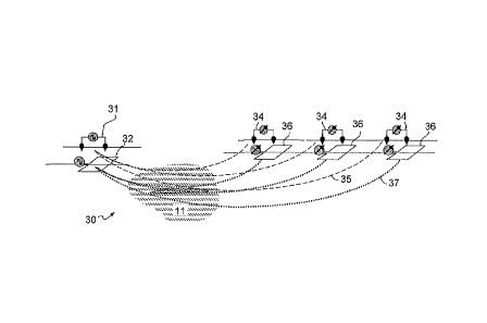
[0027] Referring now to Figure 4, an alternative embodiment of the invention
takes
advantage of the mode conversions that occur in the subsurface. In this
embodiment a
surveying system 40 comprises an inductive source 42 and a plurality of
galvanic receivers
44. Because source 42 is an inductive source, it avoids the disadvantages
associated with
galvanic sources, namely the need for conductive coupling. Instead source 42
creates signals
43 in the subsurface. As they pass through formation 11, a portion of signals
43 are
converted into electric current and become electric signal 45. The more
pronounced the
subsurface features are, the more mode conversion will occur. Electric signals
45 are
detectable by galvanic receivers 44. Thus, system 40 provides effective
hydrocarbon
exploration data, even in arid zones or regions that are otherwise not
suitable for galvanic
surveying.
[0028] Turning to Figure 5, in still another embodiment, the invention
includes using a mixed
system and mode-converted signals to obtain virtual source data. Specifically,
in one
preferred embodiment, a surveying system 50 comprises an inductive source 52
and a
plurality of galvanic receivers 54. The galvanic signals 55 that are received
at receivers 54 as
a result of mode conversion are processed using a correlation or deconvolution
virtual source
techniques so as to generate a set of "virtual signals" 57. Each virtual
signal 57 simulates a
signal received at one receiver from a "virtual source" positioned at the
location of a second
receiver. Using virtual source analysis allows the generation of virtual
galvanic sources from
real inductive sources, or vice versa. Possible real inductive sources include
naturally
occurring telluric fields.
[0029] Finally, referring to Figure 6, a system 60 comprises a plurality of
galvanic receivers
64 that detect electric signals resulting from magnetotelluric fields,
illustrated at 65. Like the
signals created by inductive sources 42 and 53, MT fields 65 undergo mode
conversion as
they pass through the subsurface. Some of this conversion results in galvanic
signals 67,
which are detected by receivers 64.
[0030] As set forth herein, the present invention provides a method by which
electromagnetic
surveys can be conducted in regions that are not conducive to galvanic
coupling, and which
can yield useful information about subsurface features that are not readily
detected by
conventional systems.
7
CA 02765546 2015-06-11
[0031] Although the invention has been described with reference to several
exemplary
embodiments, it is understood that the words that have been used are words of
description
and illustration, rather than words of limitation.
The scope of the claims should not be limited by the preferred embodiments set
forth in the
examples, but should be given the broadest interpretation consistent with the
description as a
whole.
[0032] It will further be understood that the sources and receivers of the
present invention are
intended to be used in combination with any suitable deployment, retrieval,
data collection,
data processing, and output devices, such as are known in the art.
8