Note: Descriptions are shown in the official language in which they were submitted.
CA 02771724 2012-02-21
WO 2011/022024 PCT/US2009/054665
WIND AND POWER FORECASTING USING LIDAR DISTANCE WIND SENSOR
BACKGROUND
[00011 The disclosure relates to forecasting wind velocities and in particular
to using
laser Doppler velocimeters to forecast wind velocities for wind turbine power
output management
and effective integration into the electrical grid of wind-generated power.
[0002] Wind turbines harness the energy of the wind to rotate turbine blades.
The
blade rotation is used to generate electric power. The generated power is
accessible by consumers
via a power grid, generally controlled by a utility company. However, because
wind velocities
constantly change, using a wind turbine or multiple wind turbines in a wind
farm to generate a
constant power supply for the power grid requires adapting the operation of
the wind turbine to the
changing conditions of the wind. When an entire wind farm of turbines is used
to generate power
for the power grid, each turbine must be adaptively controlled in order to
respond to the changing
wind conditions.
[0003] Currently, wind turbines are adaptively controlled and wind farm power
output is predicted based on daily or other relatively long-term weather
forecasts. Such forecasts
estimate future wind velocities based on predictive models involving isobars
or pressure gradients.
However, these forecasts lack the accuracy and timeliness required to account
for minute-by-minute
or even hourly local or regional fluctuations in wind velocity which are
critical in wind energy
production. Wind turbines may also be adaptively controlled based on wind
conditions measured at
a meteorlogical station or tower. However, such stations are expensive and
only measure wind
conditions at the location of the station. Thus, such stations do not provide
enough information to
effectively control an array of wind turbines at a wind farm which is located
remotely from the
meteorlogical station. Specifically, the sparse placement of meteorlogical
stations fails to provide
sufficient information to effectively map and predict wind conditions as they
approach a wind farm.
[0004] One of the most significant costs associated with harnessing wind power
results from these inaccurate forecasts of wind generation. Because the
electrical grid requires that
electrical generation and consumption remain in balance in order to maintain
stability, the
unpredicted short-term variability of wind velocities can present substantial
challenges to
1
CA 02771724 2012-02-21
WO 2011/022024 PCT/US2009/054665
incorporating large amounts of wind power into the electrical grid system.
Changes and
interruptions in the amount of electricity produced through wind power result
in increased costs for
regulating the electrical supply and maintaining adequate incremental
operating reserves. For
example, when wind-generated electricity levels are higher than anticipated,
an accompanying
increase in energy demand management efforts must occur, including load
shedding or storage
solutions. Alternatively, when wind-generated electricity levels are lower
than anticipated, a
sufficient reserve capacity must be maintained that can be quickly brought on-
line for those
instances. Wind power can be replaced by other power stations during low wind
periods, however
this increases costs and requires that systems with large wind capacity
components include more
spinning reserve (plants operating at less than full load). Moreover, the
above-described short-
comings of the current wind velocity measurement techniques do not allow wind
farms to
accurately forecast power output levels until it is too late. As a result,
replacing power that was
expected to be generated by a wind farm with these other sources becomes much
more expensive
and a potential road-block to increasing the percentage of renewable energy
integration.
[0005] Additionally, failure to adequately adjust direction and/or orientation
of wind
turbines in response to short-term variations in wind velocity can result in
substantial stresses being
applied to the turbines themselves. Sudden increases or decreases in load can
damage or
significantly reduce the expected lifespan or load capacity of a turbine. The
resulting repair and
maintenance costs and associated down-time are very detrimental to wind farm
profitability and
viability.
[0006] As a result of these concerns, many wind farms are operated at 30% or
more
below operating capacity, thus reducing the total amount of fluctuating power
that must be
compensated for should wind conditions change unexpectedly. For all of these
reasons, there exists
a desire and need to accurately forecast wind conditions at a wind farm well
in advance of the wind
actually reaching the wind farm so as to provide enough time to adaptively
regulate the wind
turbines to optimize electric power generation, minimize maintenance and
repair costs, and also to
enable the wind farms to notify electrical utilities in advance of any
expected power output changes.
Measured wind data from a number of sites can be networked together into a
regional or larger real
2
CA 02771724 2012-02-21
WO 2011/022024 PCT/US2009/054665
time wind picture. Such a data base supports larger scale power management
decisions and reduces
risk and uncertainty in maintaining grid capacity and stability under variable
loads.
BRIEF DESCRIPTION OF THE DRAWINGS
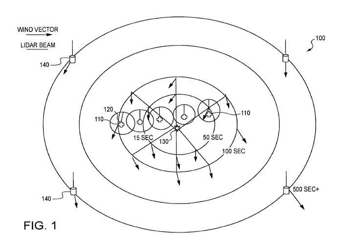
[0007] FIG. I illustrates a wind farm with LDV.
[0008] FIG. 2 illustrates a wind vector map for the wind farm of FIG. 1.
[0009] FIG. 3 illustrates a regional wind vector map.
[0010] FIG. 4 illustrates an advance notice time line for wind turbine and
electrical
grid adjustment.
DETAILED DESCRIPTION
[0011] A laser Doppler velocimeter ("LDV") may be used to determine wind
speeds
at target regions remote from the velocimeter. The LDV uses LIDAR technology.
LIDAR, which
stands for "light detection and ranging," is an optical remote sensing
technology that measures
properties of scattered light to find range and other information of a distant
target. For example, an
LDV may be used to transmit light to a target region in the atmosphere.
Objects at the target region
such as aerosols or air molecules act to scatter and reflect the transmitted
light. The LDV then
receives the reflected light from the target region. This received light is
processed by the LDV to
obtain the Doppler frequency shift, fD. The LDV then conveys the velocity of
the target relative to
the LDV, v, by the relationship v=(0.5)cfD/ft where ft is the frequency of the
transmitted light, and c
is the speed of light.
[0012] Through the use of LIDAR technology, wind conditions may be accurately
measured using an LDV that is remote from the target region. For wind
turbines, this means that a
single LDV could be used to measure wind conditions at multiple locations,
including at locations
far away from the wind turbine. By using range-gating techniques, an LDV could
make
measurements at locations far from the wind turbine as well as at intermediate
distances, thus
providing a means to track the approach of a wind front as it passes over the
surrounding terrain.
3
CA 02771724 2012-02-21
WO 2011/022024 PCT/US2009/054665
Multiple LDVs could be used, thus increasing the range of measured locations
and the resolution of
collected data within the measured area.
[0013] Target regions are selected such that wind velocity measurements at
those
regions will allow for sufficient time to adapt the wind turbines at the wind
farm to account for any
changes in wind velocity. Additional target regions may be selected that
provide additional time for
balancing load on an electric grid associated with the wind farm, thereby
allowing the powering-up
or down of additional power sources in order to compensate for changes in
power generated by the
wind farm. Through using a network of LIDAR devices, operators of wind farms
will gain
anywhere from hundreds of seconds to ten or more minutes of advance notice
regarding incoming
wind velocities.
[0014] Therefore, the invention provides a system and method for measuring
wind
conditions at ranges of several kilometers in any direction from a wind farm.
With the resultant
lead-time, a wind farm operator and an associated area power coordinator can
manage variability,
storage, and on- or off-line reserve power sources to maintain balance with
load. The wind farm
operator is also able to use the collected wind condition data to take actions
to prevent wind
overloads from overstressing the wind turbine structures or prematurely
fatiguing expensive
components such as blades and drive train. The profitability of wind energy
depends strongly on
minimizing repair and maintenance down-time and costs. Given the complex
bidding and penalty
structure of the power market, advance knowledge of the wind and, therefore,
potential power data
becomes very valuable to the operator.
[0015] In an embodiment of the disclosure, the invention includes one or more
LIDAR-based sensors designed to provide data on remote wind direction and
magnitude from
virtually any location. The sensor is capable of accuracy of better than 1 m/s
of wind speed and 1
degree of wind direction regardless of range. The maximum range of the sensor
could vary
according to needs by simply adjusting several design parameters such as laser
power, pulse
characteristics, data update rates and aperture size.
[0016] An example of a preferred LIDAR-based sensor is disclosed in U.S.
Patent
No. 5,272,513, which is incorporated by reference herein. Another example of a
preferred LIDAR-
4
CA 02771724 2012-02-21
WO 2011/022024 PCT/US2009/054665
based sensor is disclosed in International Application No. PCTIUS2008/005515,
also incorporated
by reference herein. The disclosed LDV is fully eye-safe and uses all fiber-
technology. The LDV
may be directed in a single direction, or could have multiple transceivers
directed in multiple
directions. Alternatively, the LDV could include means to rotate the
transceivers so that
measurements may be made in any direction. Mirrors could also be used to
direct transmissions
from a stationary transceiver in any direction.
[0017] While near field measurements may be useful, the LDV is also capable of
determining wind conditions at distances of one or more kilometers. The LDV
sensors may be
located on wind turbines at a wind farm, or on other stationary objects at or
near the wind farm.
Additionally, remotely-located LDV sensors may also be used to produce a more
expansive map of
wind conditions. By using both.local and remote LIDAR sensors, a combination
of micro and
macro-scaled wind mappings may be generated.
[0018] FIG. 1 illustrates one embodiment of the disclosure. In FIG. 1, a wind
farm
100 is illustrated. The wind farm 100 includes one or more wind turbines 110.
Many of the wind
turbines 110 also include an LDV 120 capable of determining wind conditions in
the near range.
The near range includes measurements of wind conditions at locations 200 to
400 meters away from
the LDV 120. For an average wind of 20 m/s, these measurements result in 10 to
20 seconds of
advance notice before the measured wind arrives at the turbine 110. In FIG. 1,
a near-range of 15
seconds is shown. In addition to the near range LDVs 120, the wind farm 100
also includes one or
more long range LDVs 130. The long range LDVs 130 are capable of making
measurements in any
direction. The long range LDVs 130 have a range of 1 to 2 kilometers. Again,
assuming an average
wind speed of 20 m/s, these measurements result in 50 to 100 seconds of
advance notice before the
measured wind arrives at the wind farm 100.
[0019] If desired, additional measurements may be made that are even more
distant
from the wind farm 100. Conceivably, these measurements could be made by a
very long range
LDV. Or, alternatively, and as illustrated in FIG. 1, these far afield
measurements may be made
using remotely located LDVs 140. These LDVs 140 are located so that
measurements made using
the LDVs 140 are 10 or more kilometers from the wind farm 100. A wind
condition measurement
CA 02771724 2012-02-21
WO 2011/022024 PCT/US2009/054665
made 10 kilometers from the wind farm 100 would provide advance notice of at
least 500 seconds
(more than 8 minutes), assuming an average wind speed of 20 m/s. Clearly,
through appropriate
LDV placement, additional measurements may be taken.
[0020] The resulting measurements may be illustrated on a wind vector map 200,
as
illustrated in FIG. 2. The map 200 includes wind velocities (speeds and
directions) for each
measured target region. The map 200 could be updated frequently, including
several times a
minute, or as frequently as measurements were made. The map 200 could be used
to determine
adjustments that must be made to wind turbines at the wind farm as well as any
local or regional
adjustments that must be made in order to maintain a stable power grid.
[0021] As additional LDVs are established and additional measurements are
made,
the wind vector map could be enlarged in both scope and resolution. FIG. 3
illustrates a regional
wind vector map 300. In the map 300, multiple LDV groupings are used to create
a map 300 that
includes instantaneous wind condition data throughout the region.
[0022] The wind vector maps 200, 300 and the measured wind conditions are used
in order to make necessary adjustments at both the wind farm and in the
regional power grid. For
example, FIG. 4 illustrates a time line 400 that shows how much advance notice
is desired in order
to make specific types of adjustments. Using the disclosed embodiments, LIDAR
wind
measurements can be used with a feedback system to control turbines and manage
power output
using measurements that provide anywhere from tens of seconds of advance
notice to 500 or more
seconds of advance notice.
[0023] With advance notice of tens of seconds, turbines can be adjusted in
order to
maintain stable wind loads. By maintaining constant loads within specified
operating parameters,
wind farm operators can minimize the wear and stress on their turbines.
Turbines are adjusted not
only to harness the wind but also to avoid sudden changes in load that often
result in turbine
damage. An advance notice of tens of seconds is also enough time for a wind
farm operator to
interface with the connecting power grid to give a warning that a power output
change is imminent.
6
CA 02771724 2012-02-21
WO 2011/022024 PCT/US2009/054665
[0024] Advance notice of tens of seconds to hundreds of seconds is necessary
in
order to bring spinning reserves on- or off-line. It is also enough time to
effectively control the
wind farm output so that the output is as stable as possible. With hundreds of
seconds of advance
notice, area operators are able to adjust the local power grid in order to
absorb the changing output
from the wind farm.
[0025] With 500 or more seconds of advance notice, other power sources
including
non-spinning power reserves are able to be brought online. And with even more
advance notice, as
provided by the regional wind vector map 300, for example, the LIDAR wind
mapping may be used
to update weather forecasts and influence bidding and pricing of the
electrical grid markets.
[0026] A simplified illustration of the disclosed feedback system is
illustrated in
FIG. 5. In method 500 of FIG. 5, wind condition measurements are made (step
510) using one or
more laser Doppler velocimeter, as illustrated in FIG. 1. Using the measured
wind conditions, a
determination is made regarding whether arriving wind conditions are different
than current wind
conditions (step 520). If there is no change in the conditions, no change need
be made at the wind
farm or on an associated power grid. However, if there is a change in arriving
wind conditions,
compensating activities must occur (step 530). One compensation activity
includes adjusting
individual wind turbines to maintain a constant load on the turbines (step
540). This also can result
in a constant power output from the wind farm. Another compensation activity
includes notifying
the power grid utilities of an expected decrease in power output from the wind
farm (step 550). Still
an additional compensation activity includes notifying the power grid
utilities of an expected
increase in power output from the wind farm (step 560). These notifications
result in actions that
allow the total power available on the power grid to remain constant, despite
changes in power
output from the wind farm. Regardless of whether compensating activities
occur, further
measurements are made to evaluate future time periods.
[0027] Therefore, by using LIDAR to solve the wind intermittency problem, many
problems are eliminated. Remote wind measurement at various ranges can provide
real time
conditions from 10 to 500+ seconds before the conditions arrive at the wind
farm. This allows for
wind mapping and change tracking. It also allows for very accurate power
variation projections. It
7
CA 02771724 2012-02-21
WO 2011/022024 PCT/US2009/054665
allows for reaction times sufficient for grid balancing, maintaining
stability, power bidding, power
ramping, application of reserves or other farm and grid management actions.
Thus, the reliable
wind data leads to lower costs, higher turbine utilization, and more reliable
grid operation.
8