Note: Descriptions are shown in the official language in which they were submitted.
CA 02773090 2012-03-02
WO 2011/031388 PCT/US2010/043898
METHOD FOR CONVERTING A DIGITAL IMAGE INTO A MULTI-
DIMENSIONAL GEO-REFERENCED DATA STRUCTURE
[0001] This Application is based upon and claims the benefit of U.S.
Provisional
Application 61/241,244 filed September 10, 2009, the entire contents of which
are
incorporated herein by reference.
FIELD OF THE INVENTION
[0002] The present invention relates generally to methods and systems for
converting
a digital image into multi-dimensional geo-referenced data structures, and
more particularly
to methods which convert digital image data into multi-dimensional geo-
referenced seismic
data structures for geologic interpretation.
BACKGROUND OF THE INVENTION
[0003] Digital images exist in many file types (e.g., tiff, jpeg, gif, cgm,
pdf), formats
(e.g. raster, vector), and can be from any source and of any subject,
including, but not limited
to: seismic lines, photographs (aerial and other), geologic cross-sections,
and well logs.
Digital images are typically used out of context and apart from computer
implemented
interpretation applications that use information related to the digital
images. For example,
geoscientists may have digital images of seismic data but cannot view and
interpret the
images in context with other data in geologic interpretation applications. The
ability to
convert digital images to georeferenced multi-dimensional data structures that
could be used
within interpretation applications would increase the value of the digital
image data.
[0004] Known methods of geo-referencing, converting and transmitting digital
images to interpretation applications have generally been limited to two
dimensional, black
and white images, and been found to be unsatisfactory. Map-view digital images
can be geo-
referenced using GIS and remote sensing applications, but the resulting data
format is not
generally compatible with other computer applications. Moving digital images
into
interpretation applications involves scanning the image into a GIS
application, manually
digitizing each pixel as vectors, and exporting the vector data through
another application.
The process is labor-intensive and provides only vectorized shapes, lacking
the detail of the
original digital image. Other methods are limited to SEG-Y output formats,
require expert
1
CA 02773090 2012-03-02
WO 2011/031388 PCT/US2010/043898
computer application skills, and are: expensive, time consuming, not suitable
for large-scale
use, and tend to result in a loss of data quality.
[0005] Although some methods have been considered, there is a need for a
method
that geo-references a digital image, converts the digital image color
information to a useful
third dimension (for example, amplitude or depth/time) and transfers the
digital image and
information to an interpretation application where the image can be viewed and
manipulated
in context with other data.
SUMMARY OF THE INVENTION
[0006] Described herein are implementations of various technologies for
converting a
digital image into a multi-dimensional geo-referenced data structure,
specifically to methods
which convert digital image data into multidimensional geo-referenced seismic
data
structures for geologic interpretation.
[0007] According to one implementation of the present invention, a computer
implemented method for converting a digital image into a multi-dimensional geo-
referenced
data structure is provided. The method includes storing a prepared digital
image; defining a
color map including values for the prepared digital image; defining geometry
and location
values for the prepared digital image; creating a data structure by assigning
to each pixel in
the digital image a value based on the closest match in the color map, and an
interpolated
geometry and location value based on the geometry and location values; and
transmitting the
data structure to an interpretation application and creating a multi-
dimensional geo-
referenced data structure for interpretation.
[0008] In another implementation of the present invention, a method for
converting a
digital image of seismic data into a 3-dimensional seismic data structure is
provided.
[0009] According to another implementation of the present invention, a
computer
system configured to convert a digital image into a multi-dimensional geo-
referenced image
is provided. The system includes at least one computer storage device having
computer
readable media including a prepared digital image, and at least one processor,
configured and
arranged to execute computer-readable executable instructions stored in
computer storage
media for enabling a user to perform a method comprising: defining a color map
having
values for the prepared digital image; defining geometry and location values
for the prepared
2
CA 02773090 2012-03-02
WO 2011/031388 PCT/US2010/043898
digital image; creating a data structure by assigning to each pixel in the
digital image a value,
based on the closest match in the color map, and an interpolated geometry and
location value,
based on the geometry and location values; and transmitting the data structure
to an
interpretation application and creating a multi-dimensional geo-referenced
data structure for
interpretation. In an embodiment, the system further includes at least one
graphical user
interface including a user input device and at least one display device
configured and
arranged to display at least one image of a multi- dimensional geo-referenced
image.
[0010] The above referenced summary section is provided to introduce a
selection of
concepts in a simplified form that are further described below in the detailed
description
section. The summary is not intended to identify key features or essential
features of the
claimed subject matter, nor is it intended to be used to limit the scope of
the claimed subject
matter. Furthermore, the claimed subject matter is not limited to
implementations that solve
any or all disadvantages noted in any part of this disclosure.
BRIEF DESCRIPTION OF THE DRAWINGS
[0011] These and other features of the present invention will become better
understood with regard to the following description, pending claims and
accompanying
drawings where:
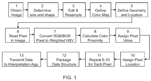
[0012] Fig. 1 illustrates a flowchart of one embodiment of the present
invention;
[0013] Fig. 2 illustrates a flowchart of another embodiment of the present
invention;
and
[0014] Fig. 3 schematically illustrates an example of a computer system for
performing the present invention.
DETAILED DESCRIPTION OF THE INVENTION
[0015] Fig. 1 illustrates a flowchart of one embodiment of the present
invention for a
computer-implemented method 30 for converting a digital image into a multi-
dimensional
geo-referenced data structure. The method includes pre-processing or preparing
a digital
image, defining a color map having values for the prepared digital image,
defining geometry
and location values for the prepared digital image, creating a data structure
by assigning the
color value of each pixel in the digital image a useful value in the data
structure, based on the
3
CA 02773090 2012-03-02
WO 2011/031388 PCT/US2010/043898
closest match in the color map, and an interpolated geometry and location
value, based on the
geometry and location values; and transmitting the data structure to an
interpretation
application and creating a multi-dimensional geo-referenced image for
interpretation.
[0016] An example of a method in accordance with an embodiment of the present
invention is described below with reference to Figure 1.
Preparin _ theme digital image.
[0017] Step 1 includes obtaining a digital image to convert, from any source,
and in
any format. For example, a seismic line, seismic time slice, horizon, map,
photograph, cross-
section, CAD drawing, x-ray, well log, illustration, or screen capture image,
each of which
can be considered to be "geological" image data. Next, a size and shape for
the digital image
is determined (step 2), manually based on the characteristics of the image.
The user makes a
judgment based on the information visible in the image, or information that is
already known
about the image. Each pixel in the image will represent one element in the
final data
structure. If the data structure should be a matrix of 20 x 20 entries, then
the image should
contain 20 x 20 pixels. For example, a seismic line is made up of traces,
evenly sampled at
set times or depths down their length. An image of seismic data should
therefore contain a
number of pixels equal to the desired number of traces (across) and samples
(down). Often
the image will actually show shotpoint or trace notations across the top and
time notations
down one side. These values can be used to determine how many pixels the
edited image
should have. These values can be entered into a spreadsheet set up to
calculate the correct
number of pixels, or the calculation can be done by hand. For example, the
determination of
the number of pixels needed in other image types is left up to the user, based
on the
resolution of the image, the desired output, and their experience with similar
images.
[0018] The digital image is then edited and resampled (step 3), to the desired
number
of pixels using an image-editing software application. A suitable application
is, but is not
limited to, Photoshop by Adobe Systems Inc. The appropriate application
should be chosen
based on its capabilities and the experience of the user. The desired output
from this step is a
raster image of pre-determined size and shape, containing only the portion of
the image
intended to be converted, and saved in a standard file format. A suitable file
format is, but is
not limited to, TIFF (Tagged Image File Format) created using the LZW lossless
compression
algorithm. Editing steps may include, but are not limited to: cropping,
compositing multiple
4
CA 02773090 2012-03-02
WO 2011/031388 PCT/US2010/043898
images, color-correcting, re-sampling. For example, a screenshot of a seismic
line may be
cropped down to the seismic data area, re-sampled to the desired size, and
saved as a TIFF
formatted image.
Defining a color map having values for the prepared digital image.
[0019] To define a color map (step 4) to enable each color in the image to be
mapped
to a numeric value, the color map is utilized as the guide the computer
follows for each color.
The user must determine what colors are present in the image and define them
as RGB
values. The colors present in the image can be determined using a number of
methods. The
user may already know the colors present based on the provenance of the image.
They may
determine the colors based on sampling tools available in image-editing
software
applications, such as the color picker in Adobe Photoshop . Image-editing
software
applications also offer the ability to choose which colors will be present in
an image.
Software algorithms that read each pixel and print its attributes, including
color, may also be
used. Once the colors present in the image have been determined, the user
inputs which color
value is associated with each numeric value to be used in the desired output
data structure.
The user may input each value manually, or use another more automated means.
One such
method is to list the colors in their intended order in a text file and input
the file to an
algorithm that defines the color bar. If the input contains fewer color values
than the
maximum available for the data structure, the user may choose to interpolate
them across all
possible values, or simply use only the values submitted. For example, 8-bit
seismic data
contains a total of 256 individual values. An image of seismic data will often
be in shades of
3 colors, 2 colors representing the extremes and one representing the middle.
The user could
supply these three colors and use an algorithm to blend them together,
interpolating the
values in between. Alternatively, it may be done with each value as an
individual color, or
any combination in between. For example, if the user intends to convert a
photograph to a
data structure that is limited to 64 values, the user may restrict the colors
in the photograph to
64 and supply only those colors to the color bar. The output of the method is
a data structure
that includes values that may be represented by colors, based on a user-
created color map.
That is, the interpretation application in which the data structure will be
used will apply its
own method and color map to "decode" the values and display them as colors. To
have the
interpretation application display the original digital image colors, the user
will generally
have to manually enter them in the application, or submit them using the
appropriate color
CA 02773090 2012-03-02
WO 2011/031388 PCT/US2010/043898
map submission tool for the interpretation application. The interpretation
application may be
used to display the data structure using any color map the user chooses.
Define geometry and location.
[0020] To define the geometry and location (step 5) to geo-reference images to
a
location in space, the user inputs the coordinates where the data structure
belongs, by either
looking at the information pictured in the image, or through known information
sources. The
amount of geometry and location information required will depend on the data
structure to be
created. For example, in a 2D seismic line, the user may submit the X and Y
coordinates and
shotpoint values for at least two points on the line, generally the ends. They
will also submit
the top and bottom values to indicate how deep into the earth the line
extends. Based on
these values, the values of the other pixels in the image are interpolated.
For example, in a
3D horizon or time or depth slice, the user may submit the X and Y coordinates
of the corners
of the image. Based on these values, the values of the other pixels in the
image are
interpolated. All descriptive information about the image file can be
submitted to the
interpretation application manually, or using batch methods. One such method
is to create
text files describing the images. The text files can be created using a script
that reads the
information from a database, spreadsheet, or other file that the user stores
image information
in.
Create a data structure.
[0021] Next, the method includes reading a pixel in the image (step 6), and
accompanying data and determine the attributes of the first pixel. This step
can include
determining if the color attributes of the image are stored as RGB or BGR
which is generally
an input that the user supplies. Next, RGB/BGR pixels are converted to
weighted HSV (step
7). This step may be implemented with any known algorithm to convert the RGB
or BGR
(red-green-blue or blue-green-red) values to HSV or HSL values (hue-saturation-
value or
hue-saturation-lightness). One example of such an algorithm is given in
Agoston, Computer
Graphics and Geometric Modeling: Implementation and Algorithms. London:
Springer, pp.
303-306 (2005).
[0022] Next, the importance of the hue, saturation and value are weighted
based on
set defaults or on user input, this will determine the correct color in the
next step. Using a
partial three dimensional Euclidean distance formula to calculate proximity to
cells in a user
6
CA 02773090 2012-03-02
WO 2011/031388 PCT/US2010/043898
defined color map, proximity of pixel color to cells in a color map is
calculated. Based on a
closest match in the color map, value is assigned to a pixel (step 9). The
number of colors
and number of values is determined based on the type of data structure
selected as the end
product. For example: commonly for seismic and horizon data, the user color
bar is 256
colors, so values of 0-255 are mapped to -128 to 127. In other words a color
bar based on
three colors like red, white and blue would map red to 1, white to 127 and
blue to 255. In this
example, 0 is the missing color bucket. If the closest index is 1 the
amplitude becomes -127.
For white an index of 127 maps to amplitude of 0. Location data is assigned to
each pixel
(step 10), using the geometry and location data submitted by the user, and
correct location
data is interpolated for the pixel. Steps 6-10 are repeated for each pixel in
image (step 11),
pixels may be processed simultaneously or serially. The resulting processed
pixels are
packaged into a data structure (step 12), by collecting each of the elements
determined in
steps 6-11 and package them according to the type of data being output. For
example, in 2D
seismic data, the package can be a seismic line with X/Y values, amplitudes,
and Z values
where the amplitude represents the color value determined at step 9. In
another example, a
3D horizon package can be a horizon with X, Y, Z values where the Z represents
the color
value determined in step 9.
Transmit data to interpretation application.
[0023] To transmit the data structure to an interpretation application (step
13), the
method 30 brings digital images into interpretation applications quickly while
maintaining
the quality and detail of the original digital images, effectively creating an
environment from
two dimensional data that can be viewed in three dimensions.
[0024] Fig. 2 illustrates a flowchart of another embodiment of the present
invention
which converts data (referred to in the Fig. and herein as horizon data) to
seismic data 40 to
enable a data structure having X, Y, Z points to be converted into a 3D
seismic cube having
X, Y, Z and amplitude points for transmitting seismic slices to an
interpretation application.
A user inputs each horizon and desired `Z' values (step 14), including the
name or number of
the horizon and the time or depth it should appear at in the final seismic
cube. This is done
for all horizons that should be included in the final cube. The user also
inputs final cube
name, format and mode (time or depth). This information is based on user
preference and
may include inferences based on prior knowledge of the data. A minimum sample
rate is
determined (step 15), by the computer. The computer reviews the user-submitted
Z value for
7
CA 02773090 2012-03-02
WO 2011/031388 PCT/US2010/043898
each of the horizons and calculates the distance (time or depth) between each
one. The
sample rate becomes the highest possible value common to all horizons (i.e.,
greatest
common factor). For example, if user submits Z values that are 100ms, 200ms,
and 300ms,
the sample rate of the cube will be 100ms. This selection will ensure that
there will be data at
all points in the cube. If the user submits values that are 100ms, 104ms,
200ms, 300ms, the
sample rate of the cube will be 4ms. Because there is no data to display at
the 4ms intervals
past 104ms, those samples will be blank spaces. Depending on the use of the
data, this may
be more desirable than data that is stretched across larger gaps. As will be
appreciated, where
the sampling algorithm introduces numerous blank spaces, compression may be
employed to
reduce the storage requirements.
[0025] For each horizon, scan lines are copied to a horizontal image (step
16). Both
three dimensional horizons and seismic lines can be raster images, for
example. Image data
is typically stored left to right, top to bottom (LtoRTtoB) for quick
displays. Seismic data (if
thought of as an image) may be stored TtoBLtoR or TtoBRtoL. When displaying
seismic
data on a computer the data is typically converted from TtoB(xxxx) to
LtoRTtoB. The scan
line is a row LtoR/RtoL or column TtoB/BtoT of data or subset of the image.
The same
concept is generally true for horizons. The horizontal image can be transposed
to a vertical
image (step 17), for example by using a matrix transpose in linear algebra.
For each vertical
scan, a new seismic trace is created (step 18). Steps 16-18 are repeated for
offset scans until
the entire image is processed (step 19). The elements determined in steps 16-
18 are collected
and packaged into a three dimensional seismic data structure (step 20),
according to the type
of data being output, by way of example, bri or.3dv files, depending on the
user input.
[0026] While in the foregoing embodiments and examples have been described in
relation to utilizing the invention to bring digital images of seismic data
into geologic
interpretation applications, it will be apparent to those skilled in the art
that the inventive
concepts described herein apply to any field that works in multiple dimensions
and has a need
to integrate digital imagery into its business interpretation applications,
for example, medical
imaging, architecture, computer aided drafting, construction, government, city
planning, law
(models of crime scenes), and many others.
[0027] In an embodiment of the present invention, a digital image is converted
to a
different data structure that is compatible with the interpretation
application the image is
needed in.
8
CA 02773090 2012-03-02
WO 2011/031388 PCT/US2010/043898
[0028] Fig. 3 schematically illustrates an example of a computer network 84,
in which
embodiments of various technologies described herein may be implemented. The
computer
network 84 may include a data processing system or computer system 88, which
may be
implemented as any conventional personal computer or server. However, those
skilled in the
art will appreciate that implementations of various technologies described
herein may be
practiced in other computer system configurations, including hypertext
transfer protocol
(HTTP) servers, hand-held devices, multiprocessor systems, microprocessor-
based or
programmable consumer electronics, network PCs, minicomputers, Linux
computers,
mainframe computers, and the like.
[0029] The computer system 88, having at least one processor, is in electronic
communication with disk storage or memory devices 86 and 96, which may be
external hard
disk storage devices. It is contemplated that disk storage devices 86 and 96
are conventional
hard disk drives, and as such, will be implemented by way of a local area
network or by
remote access. Of course, a disk may be used to store any and all of the
program instructions,
measurement data, and results as desired.
[0030] In one implementation, digital image data representative of physical
objects
may be stored as computer storage media in disk storage device 96. The
computer system 88
may retrieve the appropriate data from the disk storage device 96 to process
the data
according to program instructions that correspond to implementations of
various technologies
described herein. The program instructions may be written in a computer
programming
language, such as C++, Java and the like. The program instructions may be
stored in a
computer-readable medium, such as program disk storage device 86. Such
computer-
readable media may include computer storage media and communication media.
Computer
storage media may include volatile and non-volatile, and removable and non-
removable
media implemented in any method or technology for storage of information, such
as
computer-readable instructions, data structures, program modules or other
data. Computer
storage media may further include RAM, ROM, erasable programmable read- only
memory
(EPROM), electrically erasable programmable read-only memory (EEPROM), flash
memory
or other solid state memory technology, CD-ROM, digital versatile disks (DVD),
or other
optical storage, magnetic cassettes, magnetic tape, magnetic disk storage or
other magnetic
storage devices, or any other medium which can be used to store the desired
information and
which can be accessed by the computing system 88. Communication media may
embody
9
CA 02773090 2012-03-02
WO 2011/031388 PCT/US2010/043898
computer readable instructions, data structures, program modules or other data
in a
modulated data signal, such as a carrier wave or other transport mechanism and
may include
any information delivery media. The term "modulated data signal" may mean a
signal that
has one or more of its characteristics set or changed in such a manner as to
encode
information in the signal. By way of example, and not limitation,
communication media may
include wired media such as a wired network or direct-wired connection, and
wireless media
such as acoustic, RF, infrared and other wireless media. Combinations of the
any of the
above may also be included within the scope of computer readable media.
[0031] In one implementation, the computer system 88 may include graphical
user
interface (GUI) components such as a graphics display 90 and a keyboard 92
which can
include a pointing device (e.g., a mouse, trackball, or the like, not shown)
to enable
interactive operation. The GUI components may be used both to display data and
processed
data products and to allow the user to select among options for implementing
aspects of the
method. The computer system 88 may store the results of the methods described
above on
disk storage 86, for later use and further analysis.
[0032] The computer system 88 may be located at a data center remote from the
data
acquisition region or processing facility (not shown). The computer system 88
may be in
communication with the data acquisition receivers (either directly or via a
recording unit, not
shown), to receive signals indicative of the petrophysical properties of the
subsurface rock
structure. These signals, after conventional formatting and other initial
processing may be
stored by the computer system 88 as digital data in the disk storage 96 for
subsequent
retrieval and processing in the manner described above. While Fig. 3
illustrates the disk
storage 96 as directly connected to the computer system 88, it is also
contemplated that the
disk storage device 96 may be accessible through a local area network or by
remote access.
Furthermore, while disk storage devices 86 and 96 are illustrated as separate
devices for
storing input data and analysis results, the disk storage devices 86 and 96
may be
implemented within a single disk drive (either together with or separately),
or in any other
conventional manner as will be fully understood by one of skill in the art
having reference to
this specification.
[0033] While in the foregoing specification this invention has been described
in
relation to certain preferred embodiments thereof, and many details have been
set forth for
purpose of illustration, it will be apparent to those skilled in the art that
the invention is
CA 02773090 2012-03-02
WO 2011/031388 PCT/US2010/043898
susceptible to alteration and that certain other details described herein can
vary considerably
without departing from the basic principles of the invention. All patents and
publications
referenced herein are hereby incorporated by reference to the extent not
inconsistent
herewith.
11