Note: Descriptions are shown in the official language in which they were submitted.
CA 02777134 2015-06-22
SEISMIC ACQUISITION IN MARINE ENVIRONMENTS USING SURVEY
PATHS FOLLOWING A SERIES OF LINKED DEVIATED PATHS AND
METHODS OF USE
FIELD OF THE INVENTION
[0002] The present invention relates generally to a method and system for
acquisition of seismic data in a marine environment. More particularly, but
not by way
of limitation, embodiments of the present invention include methods and
systems for
acquiring seismic data in a marine environment using survey paths following a
series of
linked deviated paths or linked curved paths.
BACKGROUND
[0003] Marine seismic exploration investigates and maps the structure and
character
of subsurface geological formations underlying a body of water. Marine seismic
data is
typically gathered by towing seismic sources (e.g., air guns) and seismic
receivers (e.g.,
hydrophones) through a body of water behind one or more marine vessels. As the
seismic sources and receivers are towed through the water, the seismic sources
generate
acoustic energy that travel through the water and into the earth, where they
are reflected
and refracted by interfaces between subsurface geological formations. The
seismic
receivers detect the resulting reflected and refracted energy, thus acquiring
seismic data
that provides seismic information about the geological foundations underlying
the body
of water.
[0004] Typically, large arrays of seismic receivers, often numbering in the
thousands,
are used to gather marine seismic data. The seismic receivers are generally
attached to
and spaced apart along streamer cables that are towed behind a marine vessel.
CA 02777134 2012-04-10
WO 2011/059896
PCT/US2010/055699
[0005] By way of illustration of such a system, Figure 1 shows a simplified
depiction
of a conventional marine seismic data acquisition system employing a marine
vessel 10
to tow seismic sources 12 and a system 14 of steerable seismic streamers 16
through a
body of water 18.
[0006] Each of seismic streamers 16 includes a streamer cable 20, a series
of seismic
receivers 22 and a series of steering devices 24 coupled to cable 20. Relative
positions of
the marine seismic receivers during seismic data acquisition can affect the
quality and
utility of the resulting seismic data. However, unpredictable environmental
forces such
as currents, winds, and sea states present in many marine environments can
cause the
relative positions of marine seismic receivers to vary greatly as they are
towed through
the water. Therefore, it is common for steering devices (commonly know as
"birds") to
be attached to the streamer cables so that the relative positions (both
lateral and vertical)
of the seismic receivers can be controlled as they are towed through the
water. As
depicted in Figure 1, during conventional marine seismic acquisition, steering
devices 24
are used to maintain substantially constant lateral spacing between seismic
streamers 16.
[0007] As a further illustration of typical marine seismic systems, Figure
2 illustrates
a side view of marine vessel 10 towing one or more streamers 12 having seismic
sources
12 (Li) and/or seismic receivers 22 (0) through body of water 18 to acquire
seismic data
for a subterranean geological formation region of interest 26 of geological
formation 25.
[0008] As marine vessel 10 tows seismic sources 12 and receivers 22 through
body of
water 18, seismic sources 12 are simultaneously excited, which generate
acoustic wave
energy that propagates down through water 18 and into geological formation 25.
The
acoustic wave energy is then reflected and refracted by interfaces between
strata of
geological formation 25. The resulting reflected/refracted seismic energy then
passes
upwardly through water 18 and is detected by seismic receivers 22. Additional
passes are
then conducted to survey additional points of interest. The seismic data
detected by
seismic receivers 22 then provides seismic information representative of
subterranean
geological formation of interest 26.
[0009] A common problem encountered with conventional marine seismic
surveys is
"gaps" in the acquired seismic data. These data gaps can occur when the
spacing
between adjacent acquisition passes is too large to provide sufficient
resolution for proper
2
CA 02777134 2012-04-10
WO 2011/059896
PCT/US2010/055699
data processing. Gaps in seismic data can be caused by a number of factors
including, for
example, skewing of the seismic streamers relative to the direction of travel
of the towing
vessel during data acquisition. Even when steerable streamers are employed,
gaps in
seismic data are common, particularly when strong crosscurrents are present.
When
strong crosscurrents are present during seismic data acquisition, it is not
practical to
maintain all the streamers in desired orientation, because fighting strong
crosscurrents
with steering devices may produce noise that dramatically reduces the quality
of the
gathered seismic data.
[0010] When gaps in marine seismic data are discovered, if the data gaps
cannot be
filled by post-acquisition interpolation methods, the areas corresponding to
the data gaps
must be resurveyed, a process commonly known as "shooting in-fill" or "in-
filling."
Unfortunately, the existence of gaps in marine seismic data may not be
discovered until
the initial marine seismic survey has been completed and the resulting seismic
data is
being processed. Obviously, in-filling is highly undesirable because of the
significant
expense and time involved in resurveying in-fill areas that may be located
hundreds of
kilometers from one another or even retransiting the same vessel pass again to
make up
coverage.
[0011] Traditionally, marine seismic surveys using the systems depicted in
Figures 1
and 2 above are conducted using a series of straight line sail paths across a
region on
interest. That is, under conventional methods, a marine vessel and its
corresponding
streamers sail back and forth across a geological region of interest,
incrementally moving
each subsequent pass or sweep over slightly until all of the combined paths
have covered
the survey region of interest. In this way, traditional seismic surveys follow
a survey
path similar to the path followed by one mowing a rectangular section of lawn
with a
lawn mower, namely, a back and forth straight line path that is moved over
incrementally
each pass until the entire section of lawn is covered.
[0012] Referring again to Figure 1, traditional marine seismic survey
systems employ
a set of streamers where the lateral distance (df) of the forward-most seismic
receivers is
equivalent to the lateral distance (dr ) of the rearwardly-most seismic
receivers. Thus, in
surveying a region of interest, a marine vessel 10 will typically employ a
back and forth
path across a geological region of interest, moving each pass or sweep over by
roughly a
3
CA 02777134 2012-04-10
WO 2011/059896
PCT/US2010/055699
distance of 1/2df to a distance of about 1 df until the entire region of
interest is surveyed.
As will be seen below, this method of surveying suffers from a poor
randomization and
distribution of source point locations and receivers throughout the survey
area. For
example, for a ten streamer setup with dual sources towed by the streamer
vessel, df
might be about 900m but each sail line would move over about 500m.
Accordingly, this
poor randomization and distribution results in a decreased effectiveness of
post-
acquisition interpolation methods for filling in seismic data gaps in the
acquired data.
[0013]
Consequently, this method of surveying with a series of straight paths across
a
region is a highly inefficient way of gathering off-set and azimuth
distributions. Using
conventional methods to acquire wide azimuth distributions requires multiple
passes
down the same line with multiple boats, usually a single streamer vessel and
multiple
source vessels or two streamer vessels and multiple source vessels. Even using
multiple
passes and multiple vessels, the azimuth distribution acquired is still
limited in certain
directions. In this way, conventional methods of seismic surveys fail to
provide full
offset and azimuth data and further fail to optimize the randomization of the
offset and
azimuth data available. Accordingly, conventional methods of surveying a
region are
unnecessarily more costly in terms of both time and direct survey costs.
Indeed, the cost
of acquiring wide-azimuth data essentially increases by the cost of the number
of passes
required down each sail line to obtain the azimuth range required. For
conventional
marine surveys that are not wide azimuth, costs can be increased by as much as
50% by
infill needs.
[0014]
Accordingly, there is a need in the art for improved seismic survey methods
and systems that address one or more disadvantages of the prior art.
4
CA 02777134 2012-04-10
WO 2011/059896
PCT/US2010/055699
SUMMARY
[0015] The
present invention relates generally to a method and system for acquisition
of seismic data in a marine environment. More particularly, but not by way of
limitation,
embodiments of the present invention include methods and systems for acquiring
seismic
data in a marine environment using survey paths following a series of linked
deviated
paths or linked curved paths.
[0016] One
example of a method for acquiring seismic data for a subsea region of the
earth comprising the steps of: providing a marine vessel and a plurality of
seismic
streamers, wherein the plurality of seismic streamers are coupled to the
marine vessel for
towing, wherein each seismic streamer comprises a plurality of marine seismic
receivers
spaced apart along the length of each seismic streamer; providing one or more
marine
seismic sources; introducing the marine seismic sources into a marine
environment in
range of the marine seismic receivers; towing the seismic streamers through
the marine
environment such that the marine vessel and the seismic streamers travel
substantially
along a first series of linked curved paths; exciting at least one of the
marine seismic
sources simultaneously with the step of towing the seismic streamers so as to
cause
acoustic wave energy to travel through the marine environment into the subsea
region of
the earth; allowing the acoustic wave energy to reflect and refract from the
subsea region
so as to form reflected and refracted wave energy; and detecting the reflected
and
refracted wave energy with the marine seismic receivers so as to form detected
seismic
data.
[0017] The
seismic streamers may optionally be configured in a flared configuration.
In certain embodiments, the seismic streamers may be steerable so as to
achieve various
desired streamer configurations.
[0018]
Suitable examples of series of linked curved paths may include a plurality of
half-ellipses, a plurality of alternating or inverted half-ellipses,
sinusoidal wave paths, a
plurality of linked half-sine waves, a plurality of linked inverted half-sine
waves. In
certain embodiments, the survey path may form a sinusoidal wave having a
substantially
constant wavelength.
CA 02777134 2015-06-22
[0019] The lengths of the seismic streamers may vary, some configurations
extending
to a length at least as long as a quarter of the wavelength of the sinusoidal
wave or to a
length at least as long as half a wavelength of the sinusoidal wave.
[0020] Where the survey paths are comprised of a plurality of half-ellipses
that are
substantially identical in shape, the length of the seismic streamers may have
a length at
least as long as a length circumscribed by half of one of the half-ellipses or
at least as
long as the length circumscribed by one of the half-ellipses.
[0021] In certain embodiments, the survey paths of the marine vessel and the
seismic
streamers may follow a series of deviated survey paths. Examples of suitable
deviated
survey paths include triangle survey paths, square wave survey paths, or any
combination thereof.
[0022] The features and advantages of the present invention will be apparent
to those
skilled in the art. While numerous changes may be made by those skilled in the
art,
such changes are within the scope of the invention.
6
CA 02777134 2012-04-10
WO 2011/059896
PCT/US2010/055699
BRIEF DESCRIPTION OF THE DRAWINGS
[0023] A more complete understanding of the present disclosure and
advantages
thereof may be acquired by referring to the following description taken in
conjunction
with the accompanying figures, wherein:
[0024] Figure 1 illustrates a simplified overhead depiction of a
conventional marine
seismic acquisition system where the lateral spacing between the streamers is
substantially constant over the entire length of the streamers.
[0025] Figure 2 illustrates a side view of a marine vessel towing a
plurality of marine
seismic sources and a plurality of marine seismic receivers for conducting
seismic
surveys of a subsea region of the earth.
[0026] Figure 3 illustrates an exemplary pair of sinusoidal or elliptical
vessel survey
paths that may be traversed with one or more marine streamer vessels in
accordance with
one embodiment of the present invention.
[0027] Figure 4 illustrates, for comparison purposes, examples of various
possible
sail line survey paths, namely a straight sail line, a sinusoidal sail line,
and a possible
actual vessel path on a sail line.
[0028] Figure 5 illustrates a simplified overhead depiction of a marine
seismic
acquisition system where the lateral spacing between the streamers increases
rearwardly
over the length of the seismic streamers.
[0029] Figure 6 illustrates a simplified overhead depiction of a marine
seismic
acquisition system with seismic streamers shown in a flared-configuration and
more
specifically, illustrating a trumpet-shaped system of variable length seismic
streamers
exhibiting lateral streamer spacing that increases rearwardly at an increasing
rate over the
length of the seismic streamers.
[0030] Figures 7A-7D illustrates additional sail line survey paths in
accordance with
various embodiments of the present invention.
[0031] While the present invention is susceptible to various modifications
and
alternative forms, specific exemplary embodiments thereof have been shown by
way of
example in the drawings and are herein described in detail. It should be
understood,
however, that the description herein of specific embodiments is not intended
to limit the
7
CA 02777134 2015-06-22
invention to the particular forms disclosed, but on the contrary, the
intention is to cover
all modifications, equivalents, and alternatives falling within the scope of
the invention
as defined by the appended claims.
8
CA 02777134 2012-04-10
WO 2011/059896
PCT/US2010/055699
DETAILED DESCRIPTION
[0032] The
present invention relates generally to a method and system for acquisition
of seismic data in a marine environment. More particularly, but not by way of
limitation,
embodiments of the present invention include methods and systems for acquiring
seismic
data in a marine environment using survey paths following a series of linked
deviated
paths or linked curved paths.
[0033]
Methods and systems are provided for acquiring multi-azimuthal data over a
sub-surface target. In certain embodiments, a marine vessel towing multiple
seismic
streamers may be configured to travel substantially along a series of deviated
linked paths
or linked curved paths, which may optionally take the form of a series of
linked half-
ellipses, linked half-sinusoidal waves, other linked curved paths, or any
combination
thereof. In some embodiments, the survey paths of the marine vessel and its
corresponding seismic streamers substantially form a sinusoidal wave. As the
marine
vessel travels along the series the linked curved paths, one or more sources
may be
excited so as to introduce acoustic wave energy in the marine environment and
subsequently into the subsea region of the earth. The acoustic wave energy
then reflects
and refracts from the subsea region so as to form reflected and refracted wave
energy,
which is detected by marine seismic receivers that are spaced along the length
of the
seismic streamers. The detected seismic data is then interpreted to reveal
seismic
information representative of the surveyed subsea region of the earth.
[0034]
Advantages of certain embodiments of the present invention include, but are
not limited to, a reduction of the number of marine vessel runs or paths
required to
complete a survey area, increased survey efficiency and coverage, a more
effective
randomization of the locations of source point and receivers throughout the
area, a
reduction of the acquisition footprint in the final processed data, an
increase of the
effectiveness of post-acquisition interpolation methods used to fill holes or
gaps in the
acquired data, lower survey costs, decreased survey times, and maximization of
the
available offset and wide azimuth data.
[0035] Other
enhancements to the methods herein include, but are not limited to,
configuring the streamers in a flared configuration, wherein the lateral
spacing increases
9
CA 02777134 2015-06-22
rearwardly over the length of the seismic streamers or a trumpet-shaped system
of
variable length seismic streamers exhibiting lateral streamer spacing that
increases
rearwardly at an increasing rate over the length of the seismic streamers.
U.S. Patent
Application serial no. 12/167,683, filed July 3, 2008, titled "Marine Seismic
Acquisition with Controlled Streamer Flaring," describes a number of possible
streamer
configurations, streamer elements, and devices, all of which may be used in
combination with embodiments of the present invention.
[0036] Many other variations are possible as described in further detail
below. For
example, one or more additional marine vessels also towing seismic streamers
may be
used in cooperation with the first marine vessel to form any portion of the
series of
linked curved paths.
[0037] Reference will now be made in detail to embodiments of the invention,
one or
more examples of which are illustrated in the accompanying drawings. Each
example
is provided by way of explanation of the invention, not as a limitation of the
invention.
It will be apparent to those skilled in the art that various modifications and
variations
can be made in the present invention without departing from the scope of the
invention.
For instance, features illustrated or described as part of one embodiment can
be used on
another embodiment to yield a still further embodiment. Thus, it is intended
that the
present invention cover such modifications and variations that come within the
scope of
the invention.
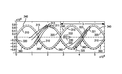
[0038] Figure 3 illustrates an exemplary pair of sinusoidal or elliptical
vessel survey
paths that may be traversed by one or more marine streamer vessels in
accordance with
one embodiment of the present invention. As described above with respect to
Figures 1
and 2, surveying a region of interest with a series of straight line paths is
an inefficient
method of gathering seismic data.
[0039] Rather, it has been discovered that surveying using a series of linked
deviated
paths or a series of curved linked paths results in a far more efficient
randomization of
seismic source and receiver locations and angles, which increases the
efficiency and
effectiveness of post-acquisition interpolation methods. Examples of survey
paths in
accordance with the present invention are shown in Figure 3. For example,
survey path
CA 02777134 2012-04-10
WO 2011/059896
PCT/US2010/055699
310 is survey path in the form of a sinusoidal wave. Survey path 320 is a
survey path
also in the form of a sinusoidal wave but inverted with respect to survey path
310.
[0040] Here,
first marine vessel 311 follows survey path 310, whereas second marine
vessel 321 follows survey path 320. In this way, each marine vessel 311 and
321 follow
survey paths that are sinusoidal and inverted with respect to one another.
[0041] First
marine vessel 311 tows seismic sources 313 and seismic streamers 315.
Likewise, second marine vessel 321 tows seismic sources 323 and seismic
streamers 325.
As each marine vessel 311 and 321 follow each survey path 311 and 321, the
paths
travelled by their corresponding seismic streamers 315 and 325 also travel
substantially
along approximately the same respective survey paths, making allowances for
wind and
ocean current influences, which may perturb the positions of seismic streamers
315 and
325 despite the corrections offered by their respective steering mechanisms,
which
attempt to correct for these external influences.
[0042] In
this way, the azimuth angles between the receivers and the sources
constantly vary throughout each survey path as each marine vessel progresses
along each
sinusoidal survey path. These varying angles result in an effective
randomization of the
offset and azimuth seismic data detected.
[0043] Many
variations of the above method are possible. Survey paths 311 and 321
may be circumscribed by one marine vessel acting alone or by two or more
marine
vessels surveying in cooperation with one another. Any number of vessels could
conduct
a survey along any portion of survey paths 311 and 321 such that the
combination of all
individual survey paths covers the entirety of survey paths 311 and/or 321.
[0044] In
certain embodiments, an optional marine vessel such as optional marine
vessel 330 may be introduced to provide a stationary or moving seismic source
or sources
333 as desired. These additional seismic sources 333 may be in addition to
seismic
sources 313 and 323 or in alternative to seismic sources 313 and 323. Seismic
sources
313, 323, and 333 may be introduced to any location within range of any
seismic
detectors being used to detect reflected and refracted acoustic wave energy
from seismic
sources 313, 323, and 333.
[0045]
Alternatively, a marine vessel could follow upper alternate survey path 340,
which is a series of linked half-sine waves, while another marine vessel
follows lower
11
CA 02777134 2012-04-10
WO 2011/059896
PCT/US2010/055699
alternative survey path 360. As before, either or both of these paths could be
surveyed by
any number of marine vessels acting in cooperation with one another, with each
vessel
surveying non-overlapping or overlapping portions of each survey path 340 and
360.
[0046] Where
multiple seismic marine vessels cooperate with one another to
complete a shared survey, it is explicitly recognized that these vessels may
operate
simultaneously with one another, sequentially with one another, time-lagged
off-set with
one another, or any combination thereof.
[0047] Figure
4 illustrates, for comparison purposes, examples of various possible
sail line survey paths, namely a straight sail line, a sinusoidal sail line,
and a possible
actual vessel path on a sail line. Sail line 410 is an example of a
conventional survey
path, which suffers from, among other things, a lack of diversity and
randomization of
offset and azimuth data. Sinusoidal sail line 420 represents an example of an
ideal sail
line survey path that results in a wider sampling and scattering of locations
and of source
points and receivers throughout the survey area. Actual vessel path on sail
line 430
represents an actual vessel path that a vessel might travel when attempting to
follow sail
path line 420 due to countervailing winds, ocean currents, and other
environmental
factors.
[0048] Marine
seismic streamer systems may employ in the range of about 2 to about
100 individual seismic streamers, in the range of about 4 to about 50
individual seismic
streamers, or in the range of about 5 to about 25 individual seismic
streamers. At least
two of the seismic streamers 36 may have a length in the range of about 0.5 to
about 30
kilometers, in the range of about 2 to 20 about kilometers, or in the range of
about 4 to
about 12 kilometers. In one embodiment, at least one-half of the seismic
streamers
employed in the seismic streamer system may have a length within one or more
of the
above-recited ranges. In another embodiment, all of the seismic streamers
employed in
the seismic streamer system have a length within one or more of the above-
recited
ranges.
[0049] In
certain embodiments, the length of the seismic streamer may vary from at
least about 1/4 of a wavelength, to at least about 1/2 of a wavelength, or to
at least about a
wavelength of the sinusoidal survey path. By increasing the length of the
seismic
streamer to correspond to a minimum length of the sinusoidal survey path, a
certain level
12
CA 02777134 2012-04-10
WO 2011/059896
PCT/US2010/055699
of offset and azimuth diversity and randomization can be assured as a result
of the source
and receiver locations as the seismic streamers travel along the survey path.
[0050] Figure
5 illustrates a simplified overhead depiction of a marine seismic
acquisition system useful in combination with certain embodiments of the
present
invention. Here, the lateral spacing between streamers increases rearwardly
over the
length of the seismic streamers, also known as a flared configuration. This
flared
configuration is especially advantageous when used in combination with seismic
survey
paths following a series of linked curved paths such as those described above.
[0051] Here,
marine vessel 30 tows marine seismic system 34 through body of water
18. Marine seismic system comprises seismic sources 32 and seismic streamers
36.
Seismic streamers 36 in turn comprise cables 38, seismic receivers 40 spaced
apart along
the length of cables 38, and steering devices 42. It is explicitly recognized
that seismic
streamers 36 may be spaced apart equidistant one another, at irregular
spacings, or any
combination thereof as desired. Steering devices 42 assist in maintaining
relative lateral
distances between seismic receivers 40 as desired.
[0052] As can
be seen in Figure 5, rearward-most group of seismic receivers 46 span
a distance dõ which is greater than the distance df, the distance spanned by
the front-most
group of seismic receivers 44. In certain embodiments, the seismic streamer
system 34 is
in a flared configuration when the lateral distance (dr) between the outer-
most, rearward-
most seismic receivers 40a,b is at least about 2 percent, at least about 5
percent, at least
about 10 percent, at least about 20 percent, or in the range of about 30 to
about 400
percent greater than the lateral distance (df) between the outer-most, front-
most seismic
receivers 40c,d.
[0053] When
coupling seismic streamers to one or more marine vessels, the term
"coupled to," as used herein, refers to both direct and indirect coupling such
that an
intervening element may exist between seismic streamer and the marine vessel.
As the
term is used herein, only the term "coupled to" requires at most an operable
coupling of
the seismic streamers to a marine vessel.
[0054] One or
more methods of the present invention may be implemented via an
information handling system. For purposes of this disclosure, an information
handling
system may include any instrumentality or aggregate of instrumentalities
operable to
13
CA 02777134 2012-04-10
WO 2011/059896
PCT/US2010/055699
compute, classify, process, transmit, receive, retrieve, originate, switch,
store, display,
manifest, detect, record, reproduce, handle, or utilize any form of
information,
intelligence, or data for business, scientific, control, or other purposes.
For example, an
information handling system may be a personal computer, a network storage
device, or
any other suitable device and may vary in size, shape, performance,
functionality, and
price. The information handling system may include random access memory (RAM),
one or more processing resources such as a central processing unit (CPU or
processor) or
hardware or software control logic, ROM, and/or other types of nonvolatile
memory.
Additional components of the information handling system may include one or
more disk
drives, one or more network ports for communication with external devices as
well as
various input and output (I/0) devices, such as a keyboard, a mouse, and a
video display.
The information handling system may also include one or more buses operable to
transmit communications between the various hardware components.
[0055] As an
example of one implementation of an information handling system for
use in combination with the present invention, seismic data is communicated to
information handling system 90, which is comprised of processor 92, data
storage device
91, display 94, and optional interpreter 93. Seismic data collected from
seismic receivers
40 may be communicated to information handling system 90 to processor 92 for
storage
in data storage device 91. The seismic data may then be interpreted by
interpreter 93.
Alternatively, in some embodiments, interpreter 93 is located external to
information
handling system 90 and consequently, this step may be performed at a later
date when
seismic data is later retrieved from data storage device 91.
[0056] Figure
6 illustrates a simplified overhead depiction of a marine seismic
acquisition system with seismic streamers shown in yet another flared-
configuration and
more specifically, a trumpet-shaped system of variable length seismic
streamers
exhibiting a rearwardly increasing rate of flaring in flared section 52 of
seismic streamer
system 50. As used herein, the "flared section" of a seismic streamer system
refers to the
section of the seismic streamer system that is in a flared configuration.
Thus, for the
seismic streamer system 34 of FIG. 5, the entire length of the streamer system
34 would
be considered a flared section. For the seismic streamer system 50 of FIG. 6,
however,
the flared section 52 has a length (1f) that is less than the total length
(it) of the seismic
14
CA 02777134 2015-06-22
streamer system 50. As depicted in FIG. 3 the seismic streamer system 50 can
also
include a non-flared/straight section 54 that exhibits substantially constant
streamer
spacing over its length (1s).
[0057] In accordance with various embodiments of the present invention, the
length
(1.1) of the flared section of a seismic streamer system can be at least 5
percent, at least
percent, at least 20 percent, at least 40 percent, at least 60 percent, at
least 80
percent, or at least 100 percent of the total length (It) of the seismic
streamer system. In
accordance with certain embodiments, the flared section of a seismic streamer
system
can exhibit an average lateral spacing between adjacent seismic streamers that
increases
rearwardly at a rate of at least 0.001 meters (lateral) per meter
(longitudinal), at least
0.002 meters per meter, at least 0.005 meters per meter, at least 0.01 meters
per meter,
at least 0.05 meters per meter, or at least 0.1 meters per meter.
[0058] Many other configurations are possible as would be recognized by a
person of
ordinary skill in the art with the benefit of this disclosure. U.S. Patent
Application
serial no. 12/167,683, filed July 3, 2008, titled "Marine Seismic Acquisition
with
Controlled Streamer Flaring," describes a number of possible streamer
configurations,
streamer elements, and devices, all of which may be used in combination with
embodiments of the present invention.
[0059] Figures 7A-7C illustrates additional sail line survey paths in
accordance with
various embodiments of the present invention. Although sinusoidal and half-
ellipse
survey paths have been specifically illustrated above, many other survey paths
are
suitable in combination with the present invention. Indeed, any survey path
comprising
a plurality of linked or connected curved paths are suitable for use with the
present
invention. Examples of suitable survey paths include, but are not limited to,
a series of
linked half-ellipses, a series of linked half-sine waves, a series of
alternating linked
half-ellipses, survey paths having a sinusoidal wave form, or any combination
thereof.
As used herein, the term "alternating" refers to survey paths in which each
crest wave is
inverted with respect to the previous wave, in an alternating crest/trough
pattem as
illustrated, for example, by the waveform shown in The amplitude and/or
frequency or
pitch of such survey paths may be constant or variable as desired depending on
various
CA 02777134 2012-04-10
WO 2011/059896
PCT/US2010/055699
factors, including the region to be surveyed, available equipment and
resources, and
external conditions such as wind direction and speed and ocean currents.
[0060]
Figures 7A, 7B, 7C and 7D show some non-limiting examples of survey paths
suitable for use with the present invention. In particular, Figure 7A shows
two survey
paths 711 and 712, each of constant wavelength k. Here, wavelength is defined
as the
distance of the survey path that spans at least two crests, two troughs, or as
indicated in
Figure 7A, the distance between two zero crossings.
[0061] Survey
path 711 is formed by a series of linked half-sine waves, whereas
survey path 712 is formed by a series of linked half-sine waves that are
inverted with
respect to survey path 711. In one embodiment, one marine vessel could travel
along a
portion of survey path 711 while a second marine vessel travels along a
portion of survey
path 712. In this way, two marine vessels acting in cooperation with one
another may
complete the combination of survey paths 711 and 712.
[0062] It is
explicitly recognized that either or both of survey paths 711 and 712 may
be surveyed by any combination of paths that when taken together form one or
both of
survey paths 711 and 721. For example, as shown in Figure 7B, one marine
vessel could
travel along survey path 721 while another marine vessel travels along survey
path 722.
Additionally, when more than one marine vessel cooperates with another marine
vessel, it
is explicitly recognized that the survey paths may be completed
simultaneously,
sequentially, time-lagged off-set with one another, or any combination
thereof.
[0063] Figure
7C shows an example of an irregular survey path 731. Here, survey
path 731 follows a series of linked curved paths wherein the amplitude and
wavelength of
each curved path vary as desired.
[0064] Figure
7D shows yet another example of a survey path in accordance with one
embodiment of the present invention. Here, survey path 741 follows a series of
linked,
deviated survey paths. The term, "deviated," as used herein refers to any
series of survey
paths, the combination of which deviates from a straight path. Examples of
suitable
deviated survey paths in accordance with the present invention include, but
are not
limited to, square wave survey paths, triangle survey paths, any of the
aforementioned
survey paths, or any combination thereof.
16
CA 02777134 2015-06-22
[0065] It is explicitly recognized that any of the elements and features of
each of the
devices described herein are capable of use with any of the other devices
described
herein with no limitation. Furthermore, it is explicitly recognized that the
steps of the
methods herein may be performed in any order except unless explicitly stated
otherwise
or inherently required otherwise by the particular method.
[0066[ Therefore, the present invention is well adapted to attain the ends and
advantages mentioned as well as those that are inherent therein. The
particular
embodiments disclosed above are illustrative only, as the present invention
may be
modified and practiced in different but equivalent manners apparent to those
skilled in
the art having the benefit of the teachings herein. Furthermore, no
limitations are
intended to the details of construction or design herein shown, other than as
described
in the claims below. It is therefore evident that the particular illustrative
embodiments
disclosed above may be altered or modified and all such variations and
equivalents are
considered within the scope of the present invention. Also, the terms in the
claims have
their plain, ordinary meaning unless otherwise explicitly and clearly defined
by the
patentee.
17