Note: Descriptions are shown in the official language in which they were submitted.
CA 02777803 2012-04-16
WO 2011/044666 PCT/CA2010/001464
1
ULTRA-SHORT BASELINE GNSS RECEIVER
BACKGROUND OF THE INVENTION
Field of the Invention
This invention relates generally to global navigation satellite systems (GNSS)
and
more particularly to short baseline receivers.
Background Information
Short baseline real time kinematic (RTK) systems typically operate with a base
GNSS receiver and a rover GNSS receiver that are separated by a small number
of
io kilometers, for example, less than 10 kilometers. The base receiver,
which is in a known
position, makes carrier phase measurements using GNSS signals transmitted from
GNSS
satellites in view and calculates pseudoranges from the respective satellites.
The base
receiver then determines differences between the pseudoranges calculated using
the
satellite signals and the ranges based on the known position of the receiver
and the
known locations of the satellites, to determine pseudorange correction
information. The
base receiver operating in a known manner broadcasts the RTK information, that
is, the
range correction information, pseudoranges, carrier phase measurements and
various
other information, to the rover receiver.
The rover receiver utilizes the broadcast pseudoranges, carrier phase
measurements and other information to resolve integer carrier cycle
ambiguities using
well known, processing intensive, operations. The rover receiver utilizes the
range
correction information to correct for pseudorange errors related to changes in
satellite
orbits, atmospheric conditions, and so forth, that affect both the base
receiver and the
rover receiver in the same manner due to the short baseline between the
receivers, all in a
known manner.
Certain short baseline systems utilize fixed baselines that may, for example,
employ two antennas situated at the rover receiver to determine the
orientation or
azimuth of the rover receiver. The antennas may be fixed to a vehicle, such as
an
CA 02777803 2016-06-06
2
automobile or a ship, and may, for example, be spaced apart by as little as 1
to% meter.
Each antennas provides information that is utilized in well known short
baseline TK
processing-intensive operations, to simplify the calculations involved in
resolving the integer
carrier cycle ambiguities for the respective antennas. Once integer carrier
cycle ambiguities
are resolved, the system can determine the azimuth or orientation of the
vehicle based on
the differences in the carrier phases measured at the two antennas.
As is well known in the art, the short fixed baseline essentially reduces the
complexity
of resolving integer cycle ambiguities by changing the solutions from those of
a 3-
dimensional problem to those of a 2-dimensional problem. However, the system
must still
engage in processing intensive and time consuming operations to solve the 2-
dimensional
problem.
SUMMARY
A GNSS receiver utilizes an antenna structure in which two antennas are spaced
apart by less than one wavelength of the GNSS satellite carrier signals of
interest. The
receiver calculates azimuth or orientation using the carrier phase angle
measurements from
the antennas directly, without having to engage in the processing-intensive
operations of
resolving integer carrier cycle ambiguities.
Without having to resolve the ambiguities, the receiver calculates the
orientation more
quickly, and can thus initialize inertial sensors, such as gyroscopes,
relatively rapidly during
start-up and/or after signal re-acquisition. Also, the orientation information
calculated directly
from the carrier phase angle measurements made by the closely spaced antennas
has zero
mean error, and may thus be utilized to maintain the calibration of the
gyroscopes.
Accordingly, less expensive gyroscopes may be used without adversely affecting
the overall
operations of the system.
The ultra-short baseline GNSS receiver may utilize a phase map as described in
United State Patent Application Ser. No. 12/579,481 entitled SHORT AND
ULTRASHORT
BASELINE PHASE MAPS. The phase map provides compensation
CA 02777803 2012-04-16
WO 2011/044666
PCT/CA2010/001464
3
for phase distortions that are related to multipath signals, antenna cross-
talk, and line
biases that are associated with receiver operations, as discussed in more
detail below.
BRIEF DESCRIPTION OF THE DRAWINGS
The present invention can be better understood with reference to the
accompanying drawings, of which:
Fig. 1 is a schematic illustration of an ultra-short baseline GNSS receiver
constructed in accordance with the invention;
Fig. 2 is a schematic illustration of an alternative ultra-short baseline GNSS
receiver constructed in accordance with the invention; and
io Fig. 3 is
a schematic illustration of another ultra-short baseline GNSS receiver
constructed in accordance with the invention.
DETAILED DESCRIPTION OF AN ILLUSTRATIVE
EMBODIMENT
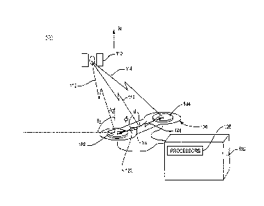
Fig. 1 is a schematic illustration of an ultra-short baseline system 100 that
receives GNSS satellite signals transmitted by a GNSS satellite 110. More
specifically,
the system 100 of Fig. 1 includes an antenna structure 106106 that consists of
dual
antennas 102 and 104 that are mounted on a rigid frame 106 and a receiver 120
with one
or more processors 126 that processes the signals received by the antennas.
The antennas
reside a distance "d"apart, where d is constrained to be less than 1
wavelength of the
GNSS satellite carrier signals of interest. The spacing d may, for example, be
less than
19 cm for a system that operates with GPS Li satellite carrier signals.
The signals from the GNSS satellite 110 are represented schematically as
signal
path 112, which is received by antenna 102, and signal path 114, which is
received by
antenna 104. The lengths of the two paths differ because of the different
locations of the
respective antennas. The signals received by the dual antennas 102 and 104 are
provided
to the accompanying receiver equipment 120, which includes one more process
126 that
are programmed to calculate the orientation of the antennas in the manner
described
below.
CA 02777803 2012-04-16
WO 2011/044666 PCT/CA2010/001464
4
By designing the antenna structure 106 with the antennas 102, 104 located
within
1 wavelength of the carrier signal, the system may determine orientation
without
reference to integer carrier cycle ambiguities because the ambiguities are the
same for the
two antennas and thus do not affect the calculations. Accordingly, the
measured phase
angles can be used directly to calculate the carrier phase difference from
which the
azimuth or orientation is determined, without having first perform the
processing and
take the time to resolve integer carrier cycle ambiguities.
There are, however, geometries in which the angle of incidence of the incoming
satellite signals results in a "roll over" from one carrier cycle to another
between the
io antennas, and thus, some ambiguity as to which direction corresponds to
the phase angle
at a given antenna, i.e., whether the phase angle rotation is plus or minus
relative to zero
degrees. However, the calculations involving signals received from other GNSS
satellites that are not then at similar sky locations provides sufficient
information to allow
the receiver to determine the correct, i.e., plus or minus, phase angle
rotation, and thus
compensate for cycle roll over,
To calculate the orientation of the antenna 102, 104, the receiver 120
determines
its position in a known manner and with sufficient accuracy to utilize the
satellite
broadcast data to determine the positions of GNSS satellites in view. The
receiver then
measures the carrier phase angles of the incoming GNSS satellite signals at
the two
antennas and subtracts the angles to produce a measured carrier phase angle
difference.
The receiver then uses the measured carrier phase angle difference directly in
the well
known calculations to determine orientation from phase difference
measurements. As an
example, the receiver may calculate orientation as:
o +B
do-- Lcosg L
A,
where do- is the expected phase angle difference, X is the wavelength of the
GNSS
carrier signal, L is the distance between the antenna phase centers, (I) is
the angle between
vector VA and the incoming satellite signal, and BL is the RF electrical line
bias between
the circuitry associated with the respective antennas.
Assuming the approximate location of the closely-spaced antennas can be
determined, the direction of the incoming GNSS satellite signal can be
ascertained from
CA 02777803 2012-04-16
WO 2011/044666 PCT/CA2010/001464
the broadcast data on the satellite signal. The cos (I) term of eqn. I can
then be calculated
using the cosine dot product:
cos (1) = ax + by + cz
where (ai + bj + ck) is the unit vector of the incoming signal from the GNS
satellite
5 signal, and (xi + yj + zk) is the unit vector of the vector VA that join
the antenna phase
centers.
In the calculation,
a ¨ cos (Az,) cos (El,)
b = sin (Az,) cos (El)
lo c ¨ sin (El,)
where the subscript "s" indicates the angles are with respect to the satellite
signal and Az
and E/ represent azimuth with respect to North and elevation angle with
respect to the
horizon, respectively. Further:
x = cos (AzA) cos (E/A)
Is y sin (AzA) cos (E/A)
z ¨ sin (E/A)
where the subscript "A" indicates the angles are with respect to the vector
VA. As will be
appreciated, other known calculations may be used to determine the angle of
incidence
between the incoming satellite signal and the vector VA based on the known
position of
20 the GNSS satellite and the known or an estimated orientation of the
antenna baseline.
The line bias BL is common to all GNSS signals received by the two antennas.
Accordingly, the line bias can be determined by, for example, adjusting the
carrier phase
differences to remove or essentially equate the geometries for various
incoming satellite
signals, such that the line bias term is the same across the calculations.
Alternatively, the
25 line bias may be determined from measurements taken when a given
satellite is
positioned at a 90 degree angle with respect to the vector VA, which is when
the carrier
phase difference should otherwise be zero. Alternatively, pairs of phase
difference
measurements could be differenced, to produce double-difference phase
observations in
which the common line bias term cancels. With the antenna spacing constrained
to less
30 than one wavelength of the carrier signal, the receiver avoids the
processing-intensive
calculations to resolve integer carrier ambiguities before determining
orientation, as is
CA 02777803 2012-04-16
WO 2011/044666 PCT/CA2010/001464
6
required for known prior systems that utilize antennas with conventional
spacing and
must use calculated carrier phase values for the signals at the respective
antennas.
In addition to the reduction in processing complexity, the antenna structure
106
has further advantages over structures with conventional antenna spacing of 1
or 'A meter.
For example, the antenna structure 106 is less costly to manufacture, utilizes
less
material, and so forth. Further, the antenna structure may be placed in
locations on, for
example, a car or other vehicle, that would not support larger antenna
structures.
The disadvantage of the short base line is reduced accuracy, with the accuracy
of
the computed orientation being inversely proportional to the baseline length
d.
Referring now to Fig. 2, a receiver 220 that incorporates the ultra-short
baseline
antenna structure 106 also includes inertial sensors 208, such as, for
example,
gyroscopes. The use of the ultra-short baseline antenna structure 106 allows
the system
to initialize the gyroscopes more quickly than prior known systems, because
the receiver
need not resolve carrier cycle ambiguities to determine azimuth or
orientation.
Accordingly, the receiver can take advantage of the gyroscope readings to
provide
updated direction information more quickly during start-up, as well as during
times in
which the receiver is reacquiring the GNSS satellite signals after signal lock
is lost. This
is particularly useful in applications designed for a moving vehicle that may,
for example,
travel under bridges or foliage canopies or through urban canyons.
Further, the orientation information calculated using the measured carrier
phase
angles directly is calculated with zero mean error, and thus, the orientation
information
may be used to maintain the calibration of the gyroscopes, such that less
expensive
gyroscopes may be used without adversely affecting the operations of the
receiver.
Referring now to Fig. 3, a receiver 300, which may be the same as either the
receiver 120 (Fig. 1) of the receiver 220 (Fig. 2) discussed above, is
included in a system
300 in which a phase map 308 is utilized to provide carrier phase difference
error values.
The error values are incorporated into the calculations to determine azimuth
or
orientation, to correct for the adverse effects of multipath signals that are
reflected from
the antenna frame 106 to the antennas 102, 104 and, as appropriate, line
biases that are
associated with the operations of the receiver. The phase map also corrects
for the
adverse affects of cross-talk between the two closely spaced antennas 102,
104, as
CA 02777803 2016-06-06
7
appropriate. The cross-talk may result in calculations that tend to shift the
phase centers of
the antennas slightly toward each other, and thus, result in errors in the
associated
calculated azimuth or orientation values.
The phase map 308 is generated as described in United States Patent
Application
Serial No. 12/579,481 entitled SHORT AND ULTRA-SHORT BASELINE PHASE MAPS.
The ultra-short baseline phase map for use with the antenna structure 106 may
thus be
generated from carrier phase angle measurements made at various times across
GNSS
satellites with the antenna structure in known locations and orientations. As
necessary, the
receiver may solve for the associated line biases using the measurements from
multiple
GNSS satellites or the measurements from the same satellite taken at various
times and/or
at the sky location in which the carrier phase angle difference at the
antennas should
otherwise be zero. The phase map is entered based on the angles of incidence
of the GNSS
satellite signals at the antennas, as is described in United States Patent
Application Serial
No. 12/579,481 entitled SHORT AND ULTRA-SHORT BASELINE PHASE MAP.
To utilize the phase map 308, the receiver 320 determines its position and
determines from satellite broadcast data or is provided with the position
coordinates of a
given GNSS satellite in view. The receiver calculates an estimated orientation
of the antenna
structure 106 based on measured carrier phase angle differences in the signals
received at
the two antennas 102, 104. As discussed above, the measured carrier phase
angles are
used directly to determine the carrier phase difference, without having to
resolve integer
carrier cycle ambiguities.
The receiver next calculates the angle of incidence of the incoming GNSS
signals
based on the known position of the GNSS satellite and the estimated
orientation of the
antennas. Using the calculated angle of incidence, the receiver enters the
phase map 308,
which may be in the form of a look-up table, and retrieves an associated
carrier phase
difference error value. The error value is used in the azimuth or orientation
calculations to
compensate for phase distortions. In the example, the receiver utilizes the
error value as a
correction to the measured phase difference, and produces an updated
orientation value by
using corrected phase difference measurements. As appropriate, the receiver
iterates by
recalculating the angle of incidence based on the updated orientation value
and
CA 02777803 2016-06-06
8
again enters the map, and so forth, until a change in the updated orientation
value is less
than the error gradient associated with the map or table entries.
As discussed, the receiver may utilize the orientation information to
initialize
gyroscopes and/or determine the direction of a moving vehicle. At the same
time or
thereafter, the receiver may operate in a known manner, using RTK information
from a base
station (not shown) and RTK short baseline techniques, to resolve the integer
carrier cycle
ambiguity using the measurements from one of the antennas 102, 104, in order
to determine
a more precise position over the short baseline, which is greater than 1
wavelength of the
GNSS carrier signal. The orientation information is used to initialize the
carrier cycle
ambiguity resolution processes utilized as part of the RTK short baseline
calculations.
Alternatively or in addition, the orientation information may be used with
pairs of antennas
arranged in corresponding longer baselines, to initialize associated carrier
cycle ambiguity
resolution processes. The corresponding longer baselines may, but need not,
include
antennas in the antenna structure as baseline end points.
Alternatively, or in addition, the receivers may operate in a system that
includes a
data collection and processing center (not shown), and the receivers may send
the carrier
phase angle measurement data to the processing center for position and/or
orientation
determination. The receivers may thus be less complex since they need not
process the
measurement data. In such a system, the processing center may collect the
carrier phase
angle measurements and batch process the data to determine which carrier phase
angle
measurements are valid in the manner set forth in co-pending United State
Patent
Application Publication No. 2006/0012516 entitled METHOD FOR POSITIONING USING
GPS IN A RESTRICTIVE COVERAGE ENVIRONMENT. The system then uses only the
valid carrier phase angle measurements to calculate orientation.
Alternatively, the processing center may calculate orientation using each set
of carrier
phase angle measurement data collected when, for example, the antennas are
located on a
moving vehicle.
The antenna structure 106 may include additional antennas (not shown). Each of
the
antennas or at least certain pairs of the antennas are spaced apart by less
than one
wavelength of the GNSS signal of interest. Accordingly, all of the antennas
may but
CA 02777803 2016-06-06
9
need not be equally spaced from one another. With more than two antennas, the
receiver
120, 220, 320 may determine the three dimensional orientation of the antenna
structure
using all or selected pairs of the antennas in a manner similar to that
described above for two
dimensions.
Alternatively or in addition, the pitch and yaw of the antenna structure may,
for
example, be determined in a manner described in United States Patent 6,21
1,821 B1
entitled Apparatus and Method for Determining Pitch and Azimuth From Satellite
Signals.
However, the carrier cycle ambiguity resolution is not performed, rather cycle
roll over
compensation is performed for the ultra-short baselines, as discussed above.
The foregoing description has been directed to specific embodiments of the
invention.
It will be apparent, however, that other variations and modifications, such as
combining
system components such as processors with a single component or separating the
processor into additional components, performing certain or all of the
processing operations
in software, hardware or firmware, performing certain processing operations at
a processing
center and other processing operations at a receiver, performing steps out of
order, and so
forth, may be made to the described embodiments, with the attainment of some
or all of the
advantages of such. Accordingly, this description is to be taken only by way
of example and
not to otherwise limit the scope of the invention.