Note: Descriptions are shown in the official language in which they were submitted.
CA 02778336 2016-12-19
METHOD FOR REMOTE IDENTIFICATION AND CHARACTERIZATION OF
HYDROCARBON SOURCE ROCKS USING SEISMIC AND ELECTROMAGNETIC
GEOPHYSICAL DATA
[0001] (This paragraph intentionally left blank.)
FIELD OF THE INVENTION
[0002] This invention relates generally to the field of hydrocarbon
exploration, and
more particularly to identification and characterization of hydrocarbon (oil,
gas, and natural-
gas liquids) source rocks in onshore and offshore sedimentary basins, using
combined
seismic and electromagnetic geophysical data acquired at or near the surface
of the earth, sea,
or seafloor. The invention also relates to subsurface formation interval
seismic velocity, bulk
density, and electrical resistivity measured from well logs in a borehole as
means to calibrate
the seismic and electromagnetic geophysical data.
BACKGROUND OF THE INVENTION
[0003] A key element in successful hydrocarbon exploration is the
existence of
adequate source rock in the basin, in terms of both total organic content
(TOC) and level of
organic metamorphism (LOM) or "maturity". In undrilled or poorly explored
basins, source
adequacy is essentially unknown and is a major exploration risk. However, once
a well is
drilled, a formation evaluation method called DeltaLogR (or ALogR) is
available to assess
source rock quality, using overlays of suitably scaled resistivity log and
sonic log (or density
log) data. See Passey et al., "A Practical Model for Organic Richness from
Porosity and
Resistivity Logs," AAPG Bulletin 74, 1777-1794 (1990).
The DeltaLogR method relies on first-order rock physics that predicts
reduced vertical acoustic velocities (due to the presence of kerogen) and
increased horizontal
resistivities (reflecting kerogen content and in-situ generation of
hydrocarbons) in organic-
rich rocks as functions of TOC and LOM. The present invention is a method to
perform
- -
CA 02778336 2012-04-19
WO 2011/056444 PCT/US2010/053512
DeltaLogR analyses in the absence of a well at the point under investigation,
using seismic
and electromagnetic geophysical data measured remotely.
[0004] Hydrocarbon source rock mapping in untested (un-drilled)
basins, and in
unexplored areas of explored basins, has been addressed primarily by
geological
interpretation of seismic reflection patterns (K. M. Bohacs, 1998,
"Contrasting Expressions
of Depositional Sequences in Mudrocks From Marine to Non-Marine Environs,"
Shales and
Mudstones I, Schweizerbart'sche Verlagbuchhandlung, pp. 33-78); by basin
history and
evolution modeling, and by basin analog and environment-of-deposition studies
(Bohacs et
al., "Production, Destruction, and Dilution - The Many Paths to Source-Rock
Development,"
SERVI Special Publication 82, 61-101 (2005); S. Creaney and Q. R. Passey, op.
cit. 1993).
However, these approaches have large uncertainties, and generally have not
definitely
identified the presence of adequate source rocks. Source rocks typically
occupy a relatively
small fraction of total shale volume, and may not have clear seismic
reflection boundaries
within the shale interval, so their detection can be difficult. Known source
rocks of
commercial importance vary in thickness within a common range of about 30 to
300 meters.
What is needed is a remote geophysical method, having at least moderate
vertical resolution
and accuracy that can identify and characterize source rocks in this thickness
range, and that
has a useful subsurface/sub-seafloor depth of investigation to 3000 meters or
more. Given
the increasingly limited commercial access to sedimentary basins due to
several factors,
remotely identifying source rock in unexplored areas would have substantial
benefits for
worldwide exploration opportunities. The present invention's method for
combining seismic
and electromagnetic geophysical data satisfies this need.
1. DeltaLogR Borehole Method
[0005] DeltaLogR is a proven technique for identifying and calculating
TOC in
organic-rich rocks using well logs. (Passey et al., supra; see also Creaney
and Passey,
"Recurring Patterns of Total Organic Carbon and Source Rock Quality Within a
Sequence
Stratigraphic Framework," AAPG Bulletin 77, 386-401 (1993); Meyer and
Nederlof,
"Identification of Source Rock on Wireline Logs by Density/Resistivity and
Sonic Transit
Time/Resistivity Crossplots," AAPG Bulletin 68, 121-129 (1984); Meissner,
"Petroleum
Geology of the Bakken Formation Williston Basin, North Dakota and Montana," in
The
Economic Geology of the Williston Basin, Montana Geological Society, 1978
Williston Basin
Symposium, 207-227; and "Method for Evaluating the Content of Organic Matter
of
- 2 -
CA 02778336 2012-04-19
WO 2011/056444 PCT/US2010/053512
Sedimentary Rocks From Data Recorded in Wells by Logging Sondes," French
Patent No.
2,674,961 to Ros, Carpentier and Huc (Apr. 8, 1991)) The method employs the
overlay of a
log response scaled to represent total porosity (usually the sonic transit-
time log) onto a
scaled resistivity curve that preferably measures deep formation resistivity.
The log
resistivity that is measured is usually assumed to be the horizontal
component, due primarily
to the design of the borehole tool. Conversely, the log sonic transit time
that is measured is
usually assumed to be the vertical component, again due primarily to the
design of the
borehole tool. The response scaling is performed using baselines for the logs
in non-source
clay-rich rocks such as shales, identified using primarily the gamma-ray (GR)
log. In the
common practice of the DeltaLogR art, the transit-time curve and the
resistivity curve are
scaled so that their relative magnitude is -100 microseconds/foot of transit
time per two
logarithmic resistivity cycles. In low-TOC water-wet porous rocks, the two
curves are very
nearly parallel and can be closely overlain, since both respond to porosity.
But in high-TOC
source rocks (or in reservoirs that contain hydrocarbons) a separation occurs
between these
curves due to two main effects: 1) the porosity curve responds to the presence
of low-density
low-velocity kerogen, and 2) the resistivity curve responds to the formation
fluid. Level of
organic metamorphism (LOM) is estimated in several ways, including vitrinite
reflectance of
subsurface samples and estimates of thermal and burial history. LOM describes
thermal
maturity (metamorphism) of sedimentary organic matter during burial¨the
cumulative effect
of exposure to elevated temperature. It is a numerical scale (zero to twenty)
which is
applicable to the entire thermal range of generation and destruction of
petroleum. When
maturity is low and no hydrocarbons have been generated, the curve separation
is caused
only by the porosity response to low density and/or low velocity TOC.
Conversely, when
maturity is high in such organic-rich rocks or in hydrocarbon-bearing
reservoirs, the
resistivity response increases due to the generated hydrocarbons.
[0006] Figures 1A-C depict the solid and fluid components in
hydrocarbon source
and non-source rocks. Organic-rich rocks are assumed to be composed of three
components:
(1) the rock matrix, (2) the solid organic matter, and (3) the fluid(s)
filling the pore space,
typically water or oil/gas. Non-source rocks are composed primarily of only
two
components: the matrix and the fluid filling the pore space (Fig. 1A). In
immature source
rocks, solid organic matter and rock matrix make up the solid fraction, and
formation water
fills the pore space (Fig. 1B). As the source rock matures, a portion of the
solid organic
matter is transformed to liquid (or gaseous) hydrocarbons, which move into the
pore space,
- 3 -
CA 02778336 2012-04-19
WO 2011/056444 PCT/US2010/053512
displacing the formation water (Fig. 1C). The magnitude of the curve
separation in non-
reservoir rock intervals is then calibrated to TOC and LOM from core samples
and from
empirical and/or statistical relationships from the same or similar
sedimentary basins. The
DeltaLogR method can thus be used to assess organic richness of subsurface
formations in a
wide variety of facies and lithologies as depicted in Figs. 2 and 3. Note that
the gamma ray
log in Fig. 2, which aids in interpretation of the depth intervals and
confirms identification
and elimination from the analysis of reservoir intervals, would normally not
be available in
situations where the Remote AI ogR of the present invention is applied,
because it is the
organic-rich source intervals that are of interest.
[0007] In applications of DeltaLogR, the amplitudes of the transit-time
curve (21 in
Fig. 2) and the resistivity curve (22) are scaled such that their relative
scaling is -100
,tt sec/ ft (-328 ,tt sec/ m) per two logarithmic resistivity cycles (i.e., a
ratio of -50 it sec/ ft or
-164 , u sec/ m to one resistivity cycle), as is indicated by the AT and AI
ogR scales at the
bottom of Fig. 2. The two curves are overlain, i.e. baselined, in fine-
grained, "non-source"
rock intervals such as zones A and E in Fig. 2. A baseline condition exists
when the two
curves "track" or directly overlie each other over a significant depth range.
Typically, zone
A may extend upward for a considerable distance, but for display purposes,
this is truncated
in Fig. 2 leaving only the lower portion. The discovery underlying DeltaLogR
was that after
the aforementioned scaling and baselining, the irregularities of intervals
such as A and E
match up very well. With the baseline established, organic-rich intervals can
be recognized
by separation and non-parallelism of the two curves, such as the intervals
labeled "immature
source" and "mature source" in Fig. 2. The separation between them, designated
as Alog R
in Fig. 2, can be measured at each depth increment. It may be noted that both
zones C and F
exhibit significant AI ogR separation. It is difficult to differentiate the
two zones from the
sonic log alone, but the resistivity log distinguishes them. In zone C, the
resistivity log
shows no deviation from the baseline, but in zone F the resistivity increases,
indicating that
hydrocarbons have displaced water in the pore spaces, thereby increasing
resistivity. Thus,
zone F is mature source rock whereas zone C is immature source rock.
[0008] The AI ogR separation is linearly related to TOC and is a
function of maturity.
Using a AI ogR calibration diagram such as Fig. 3, the ALogR separation can be
transformed
directly to a quantitative estimate of TOC if the maturity (in level of
organic metamorphism
units, LOM; see for example Hood et al., 1975) can be determined or estimated.
In practice,
- 4 -
CA 02778336 2012-04-19
WO 2011/056444 PCT/US2010/053512
LOM is obtained from a variety of sample analyses (e.g. vitrinite reflectance,
thermal
alteration index, or T. from RockEval pyrolysis), or from estimates of burial
and thermal
history. If the maturity (LOM) is incorrectly estimated, the absolute TOC
values will be
somewhat in error, but the vertical variability in TOC will be correctly
represented. With
reference to Fig. 3, the dark line 31 should be used for maturity less than
LOM 6. Immature
source rock has LOM of 6 to 7 or less. The LOM range of approximately 7-11
indicates
mature source rock, meaning that oil or gas should be present in the vicinity.
Above LOM 11
is considered over-mature source rock; an example is shale gas. The DeltaLogR
method
works even in the over-mature source rock range, and therefore, as will be
explained below,
so does the present inventive method. Experience has shown that an LOM in the
10-10.5
range should be used for LOM 11 or greater for estimating TOC; i.e., the
portion of Fig. 3
below LOM;--,' 10.5 should not be used. Moreover, the DeltaLogR method is also
known to
work on coals except that that the calibration of AI ogR to TOC will not be
the same as for
organic-rich shales. The coals are still easily recognized, but the DeltaLogR
method will
under-predict TOC in a coal if the calibration of Fig. 3 is used -- e.g.,
DeltaLogR might
predict TOC will be 20-30 wt%, whereas, the real TOC may be 60-80 wt%. Coal
covers the
entire maturity scale: LOM < 1 is called peat; LOM in the range 1-4.5 is
called lignite coal;
LOM in the range 4.5-7 is called sub-bituminous coal; LOM in the range 7.5-13
is called
bituminous coal; and LOM > 13 is called anthracite coal. In the claims, the
term
hydrocarbon source rock potential will be understood to include coal
potential.
[0009] For the example in Fig. 2, the maximum ALogR separation is
approximately
0.7 of a logarithmic resistivity cycle (i.e. A/ ogR = 0.7). If the LOM is 6-7,
this can be seen
from Fig. 3 to correspond to a TOC value of approximately 12 %. In this
manner, a TOC
value depth profile may be calculated from Figs. 2 and 3.
SUMMARY OF THE INVENTION
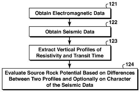
[0010] In one embodiment, with reference to the flow chart of Fig. 12,
the invention
is a method for remotely assessing hydrocarbon source rock potential of a
subsurface region,
comprising: (a) obtaining electromagnetic field data representative of the
subsurface region
from a survey conducted above the subsurface region (step 121); (b) obtaining
reflection data
from a surface seismic survey of the subsurface region (step 122 ¨ order
relative to step 121
does not matter); (c) extracting a vertical profile of resistivity or its
reciprocal, conductivity,
from the electromagnetic data and a vertical profile of acoustic velocity or
its reciprocal
- 5 -
CA 02778336 2012-04-19
WO 2011/056444 PCT/US2010/053512
quantity, transit time, from the seismic reflection data, thus generating two
profiles
hereinafter called the resistivity profile and the transit time profile (step
(123); and (d)
evaluating depth intervals in the subsurface region for source rock potential
based on
differences between the two profiles and, optionally, on the character of the
seismic reflection
data (step 124). In practical applications of the invention, at least step (c)
will be performed
using a computer.
BRIEF DESCRIPTION OF THE DRAWINGS
[0011] The present invention and its advantages will be better
understood by referring
to the following detailed description and the attached drawing in which:
[0012] Figs. 1A-C depict solid and fluid components in non-source and
source rocks;
[0013] Fig. 2 is a schematic for interpretation of DeltaLogR well log
responses in a
variety of subsurface formations;
[0014] Fig. 3 shows calibration of TOC to LOM for the well-log-based
DeltaLogR
diagram tool, as disclosed in Passey et al. supra;
[0015] Fig. 4 shows vertical accuracy and spatial resolution of a model 1D
resistivity
profile, at two inversion bandwidths (0.0-0.25 Hertz and 0.0 - 1.0 Hertz);
[0016] Figs. 5A-B illustrate typical marine (A) and land (B) seismic
data acquisition
for subsurface geologic imaging and interval velocity determination;
[0017] Fig. 6 depicts marine controlled-source electromagnetic (CSEM)
data
acquisition for subsurface resistivity determination;
[0018] Fig. 7 shows an anisotropic (VTI) shale (clay-sand) model
containing depth-
dependent TOC;
[0019] Figs. 8A-D depict the changes in P-wave vertical and horizontal
interval
transit times (reciprocal velocities), and the horizontal and vertical
resistivities, as TOC is
varied using the VTI rock model shown in Fig. 7;
[0020] Figs. 9A-D depict the changes in shear-vertical (Sv-wave)
vertical and
horizontal interval transit times (reciprocal velocities), and the horizontal
and vertical
resistivities, as TOC is varied using the VTI rock model shown in Fig. 7;
[0021] Figs. 10A-D depict the changes in shear-horizontal (Sh-wave)
vertical and
horizontal interval transit times (reciprocal velocities), and the horizontal
and vertical
- 6 -
CA 02778336 2012-04-19
WO 2011/056444 PCT/US2010/053512
resistivities, as TOC is varied using the VTI rock model shown in Fig. 7;
[0022] Fig. 11 is a schematic diagram of Remote DeltaLogR response
from seismic
and remote resistivity data, compared with DeltaLogR from well logs; and
[0023] Fig. 12 is a flow chart showing basic steps in one embodiment
of the present
inventive method.
[0024] The invention will be described in connection with example
embodiments.
However, to the extent that the following detailed description is specific to
a particular
embodiment or a particular use of the invention, this is intended to be
illustrative only, and is
not to be construed as limiting the scope of the invention. On the contrary,
it is intended to
cover all alternatives, modifications and equivalents that may be included
within the spirit
and scope of the invention, as defined by the appended claims.
DETAILED DESCRIPTION OF EXAMPLE EMBODIMENTS
[0025] The present invention extends the well known DeltaLogR well-
based method
for estimating hydrocarbon source rock TOC, so that it is performed using
seismic and
electromagnetic geophysical data acquired remotely from the subsurface
hydrocarbon source
rock. Formation interval velocities derived from the seismic data, and
formation resistivity
data derived from the electromagnetic data (preferably controlled-source
electromagnetic
("CSEM") survey data), are used instead of well log sonic and resistivity data
from wells,
respectively, to produce a new Remote DeltaLogR (or "RDeltaLogR") response.
This new
response is interpreted in conjunction with the overall character of the
seismic reflection data
(including continuity, geometry, and reflection amplitude) in cross-section,
map, and volume
views to further distinguish source rock from hydrocarbon reservoir rocks that
can also
exhibit an RDeltaLogR response, and from fine-grained non-source rocks such as
low TOC
shales. The present inventive method uses the character in seismic reflection
data of a target
interval to differentiate potential organic-matter-rich rocks (ORRs) from
potential
hydrocarbon reservoir rocks, since both potential ORRs and hydrocarbon
reservoirs have
sonic-resistivity separation. Whereas A.LogR uses only the local vertical P-
wave (acoustic)
velocity and horizontal resistivity as measured by borehole tools, and does
not address
anisotropy, the present inventive method transcends both of these limitations.
Moreover,
deriving the interval transit times from seismic data is significantly
different from the directly
measured sonic transit time in the borehole. Character in seismic reflection
data includes the
appearance of the thickness, continuity, geometry, and amplitude, along with
their lateral
- 7 -
CA 02778336 2012-04-19
WO 2011/056444 PCT/US2010/053512
rates of change of a target stratigraphic interval in cross-section, map, and
volume views. To
clarify terminology, organic rich rock (ORR) is the broadest term used to
refer to the
presence of organic carbon. Source rock is mature ORR. Potential source rock
itself can be
mature or immature. Mature source rock has evolved to the extent that
hydrocarbons (oil or
gas) have been produced, and they will be found either in the source rock
interval or migrated
to a nearby zone.
[0026] ORRs have distinctive impedance contrasts because of the
influence of
organic-matter (kerogen) content on seismic velocity and rock density that can
contrast
significantly with surrounding non-ORRs (such as organic-matter-poor
mudstones, siltstones,
sandstones, evaporites, or carbonates). The three-dimensional spatial
distribution of their
seismic character is a function of their depositional processes. They tend to
have broadly
distributive patterns, relatively low sediment accumulation rates, and
relatively minor
truncation and erosion, all indicating generally low levels of water bottom
energy. Although
ORRs may be relatively thin and may not always generate their own particular
seismic
response, they are associated with relatively thick intervals (100's of
meters) of fine-grained
rocks that share many of the same depositional attributes as the ORR interval.
This contrasts
sharply with the seismic character of coarse-grained stratal units that have
more channelized
patterns, relatively high sediment accumulation rates, and common occurrence
of indicators
of higher levels of water bottom energy, such as erosion and truncation.
[0027] In cross-section (vertical slice) view, the key characteristics
include the
continuity, geometry, and amplitude of seismic reflections, along with their
lateral rates of
change. ORRs tend to have seismic reflections that have broader lateral
continuity, parallel
to sub-parallel geometry and distinctive amplitudes that vary laterally at the
kilometer to
tens-of-kilometers scale. Amplitudes tend to be relatively high where ORRs are
interbedded
with carbonates, well-cemented mudstones, or coarse-grained clastics.
Amplitudes tend to be
relatively low, but laterally consistent where ORRs are interbedded with
organic-matter-poor
mudstones or claystones. At a sub-regional scale, ORRs tend to be associated
with downlap
and onlap surfaces.
[0028] In map or volume view, potential ORRs tend to have broadly
distributive or
tabular patterns, commonly draping pre-existing geometries or thickening into
subsiding low
areas. They tend to thin laterally at the kilometer to tens-of-kilometer
scale, except where
truncated by an erosional surface. In the absence of truncation, thinning of
ORRs tends to be
associated with downlap or onlap geometric relations in reflection seismic
data, but may
- 8 -
CA 02778336 2012-04-19
WO 2011/056444 PCT/US2010/053512
result in a more pronounced seismic reflector due to concentration or
amalgamation of
organic matter. Coarse-grained reservoir-prone strata are distinguished by
their generally
channelized to narrowly distributive patterns, abrupt lateral changes in
thickness, and
common lateral termination by onlap or truncation.
[0029] An advantage of the present inventive method is that it does not
need well data
from the exploration area of interest. However, if well data are available
from another
geologically similar area that can be extrapolated to the exploration area,
including density
log data, that can optionally be used to help calibrate the RDeltaLogR method
in the
exploration area. A brief background summary of typical seismic and
electromagnetic survey
methods follows next.
Seismic methods
[0030] The seismic reflection method is the dominant technique for
imaging geologic
structure and stratigraphy within the earth, and estimating rock and fluid
properties for the
hydrocarbon industry. A large body of published literature describes this
established seismic
method and its applications, well known to practitioners of the geophysical
art. Depictions of
typical examples of the seismic reflection data acquisition method used both
in a body of
water and on land, are shown in Figs. 5A (water) and 5B (land). In Fig. 5A, a
ship tows a
seismic source followed by a streamer of seismic receivers. In the land
example shown in
Fig. 5A, a vibrator source is being used, and a string of geophone receivers
is shown,
electrically connected to a recording truck. In both drawings, example
raypaths are shown
reflecting from subsurface interfaces, back up to the surface where they are
recorded along
with their arrival times. A critical aspect of the seismic method is
determination of
subsurface physical velocities associated with the propagation speeds of P and
S-waves in the
geologic formations. Seismic velocity estimation is essential for summing (or
"stacking")
data from an ensemble of receiver measurements made at different source-to-
receiver
distances, so as to construct an image of the reflection point in the
subsurface from more than
a single recording position. Many methods have been developed over the past 90
years or so
and are now used for velocity estimation, including normal-move-out analysis
of seismic
reflection pre-stack ensemble ("gathered") responses, seismic reflection and
refraction
tomography, and seismic wave focusing (imaging) during data migration that
repositions
reflections and diffractions to their correct subsurface locations. A general
survey of such
known methods may be found in Interval Velocities from Seismic Reflection Time
Measurements by Hubral, SEG, Tulsa, 203 pages (1980). The simplest method for
- 9 -
CA 02778336 2012-04-19
WO 2011/056444 PCT/US2010/053512
estimating P-wave speeds in flat subsurface layers, or determining "interval
velocities", is the
Dix approximation (Dix, "Seismic Velocities From Surface Measurements,"
Geophysics 20,
68-86 (1955)).
[0031] Equally important is the need to combine data of different
source-to-receiver
offsets, since seismic data are much like "echoes" that are measured as
arrival events in terms
of their total travel time (in seconds) from source to receiver, the true
depth structure of the
earth is not known (i.e. wave travel time converted to depth) until the
subsurface seismic
velocities are estimated or directly measured. Velocity estimation methods for
depth
conversion are summarized by Harlan et al. ("Introduction to the Supplement on
Velocity
Estimation for Depth Imaging," Geophysics 73, pp. VE1-VE3 (2008). In many
cases, the
subsurface velocities depend upon the direction of propagation of the waves,
which effect is
called anisotropy. In most cases this seismic velocity is roughly uniform in
all horizontal
directions, but is smaller in the vertical direction. Such anisotropy is
called vertically
transverse isotropy (VTI), or simply vertical anisotropy. This further
complicates the
velocity estimation problem, but methods have been developed to account for
the effect. See,
for example, Alkhalifah and Tsvankin, "Velocity Analysis for Transversely
Isotropic Media,"
Geophysics 60, 1550-1556 (1995). Most methods used for seismic interval
velocity
estimation produce values for the horizontal component of the velocity.
Estimates of vertical
seismic interval velocity are obtained in a number of ways, ranging from
simple scaling of
the vertical value from the horizontal measured value, to complex imaging
techniques such as
anisotropic migration and anisotropic inversion.
[0032] Even if a well bore is available in the area of the survey, in
which the velocity
of seismic waves (using the vertical P-wave value, from sonic transit time log
data) are
measured locally using a well logging device, velocity estimation for the
whole area can be
difficult and will contain uncertainties. For the purposes of the present
invention, a variety of
seismic velocity estimation methods may be used. Preferred methods are those
that are most
sensitive to variations in TOC, and that produce the highest accuracy and
spatial resolution
for a given area which in turn will depend on the seismic data quality and the
complexity of
the geology.
[0033] A number of seismic forward- and inverse-modeling methods are
available for
determining density and either velocities or acoustic moduli from seismic
data. See for
example: Tarantola, "Inversion of Seismic Reflection Data in the Acoustic
Approximation,"
- 10 -
CA 02778336 2012-04-19
WO 2011/056444 PCT/US2010/053512
Geophysics 49, 1259-1266 (1984); Carazzone 1986, "Inversion of P-SV Seismic
Data,
Geophysics" 51, 1056-1068 (1986); Symes and Carazzone, "Velocity Inversion by
Differential Semblance Optimization," Geophysics 56, 654-663 (1991); Squires
et al., "The
Effects of Statics on Tomographic Velocity Reconstructions," Geophysics 57,
353-363
(1992); and Stoffa and Sen, "Nonlinear Multiparameter Optimization Using
Genetic
Algorithms: Inversion of Plane-Wave Seismograms," Geophysics 56 1794-1810
(1991).
Seismic velocity and density estimates are then combined to estimate porosity,
either using
rock physics models or using mathematical inversion. It is important to note
that the vertical
resolution of seismic velocities is typically much less than the vertical
spacing of individual
reflectors (reflector resolution is theoretically 1/4th of a vertical
wavelength), since velocity
information is contained mostly in the varying times of reflection arrivals in
the multiple-
trace ensemble ("gather") of responses, which is a low-frequency measurement.
New
techniques that attempt to mathematically invert the full waveforms of the
seismic data in
order to estimate velocities and densities at the highest possible resolution
and accuracy may
overcome this velocity resolution limitation (Singh et al., "Full Elastic
Waveform Inversion:
Future of Quantitative Seismic Imaging," 78th Annual International Meeting,
SEG Expanded
Abstracts, (2008)).
[0034] Limited attempts have been made to identify source rocks
directly from
attributes of seismic reflection pre-stack responses. For example, theoretical
and 1D model
studies of an ideal isolated source rock layer imbedded in a uniform isotropic
half-space
suggest that the organic content of the source rock could be obtained from
amplitude-versus
offset (AVO) analysis of seismic primary (P-wave) and converted wave (P-wave
to S-(shear)
wave)) reflections, at least for TOC > 10%; see Carcione, "AVO Effects of a
Hydrocarbon
Source-Rock Layer," Geophysics 66, 419-427 (2001). However, Carcione's
theoretical
method contains considerable ambiguity (trade-off) between kerogen content and
hydrocarbon source layer thickness. In addition, the complexity and spatial
variations of
physical parameters in the real subsurface makes the interpretation of such
coupled P- and S-
wave AVO effects highly problematic for determining source rock properties.
Carcione's
method is not known to be used in the source rock determination art. Other
references
include Vernick and Nur, "Ultrasonic Velocity and Anisotropy of Hydrocarbon
Source
Rocks," Geophysics 57, 727-735 (1992); and Meyer and Nederlof, "Identification
of Source
Rocks on Wireline Logs by Density/Resistivity and Sonic Transit
Time/Resistivity
Crossplots," AAPG Bulletin 68, 121-129 (1984).
- 11 -
CA 02778336 2012-04-19
WO 2011/056444 PCT/US2010/053512
Electromagnetic geophysical methods
[0035] Both natural-source (such as magnetotellurics) and controlled-
source
electromagnetic methods have been used in hydrocarbon exploration since early
in the 20th
century. Recent advances in electromagnetic geophysical methods, especially
marine
controlled-source electromagnetics (CSEM), make it possible to remotely
measure the bulk
horizontal and vertical electrical resistivity of subsurface formations with
considerable
accuracy but at fairly low vertical resolution, typically 5-10% of the depth
below the surface
(Ellingsrud et al., "Remote Sensing of Hydrocarbon Layers by Seabed Logging
(SBL):
Results From a Cruise Offshore Angola," The Leading Edge 21, 972-982 (2002);
Srnka et al.,
"Remote Reservoir Resistivity Mapping - an Overview," The Leading Edge 25, 972-
975
(2006); Jing et al., "CSEM Inversion: Impact of Anisotropy, Data Coverage, and
Initial
Models", 78th Annual International Meeting, SEG, Expanded Abstracts (2008).
CSEM
surveying has become an important geophysical tool for evaluating the presence
of
hydrocarbon-bearing reservoirs within the earth (Constable and Srnka, "An
Introduction to
Marine Controlled-Source Electromagnetic Methods for Hydrocarbon Exploration,"
Geophysics 72, pp. WA3-12 (2007)). In this method a controlled electromagnetic
transmitter
is towed above or positioned between electromagnetic receivers on the
seafloor, such as
disclosed in U.S. Patent No. 6,603,313 to Srnka and PCT Patent Application
Publication WO
2004/083898 by Eidesmo et al. Figure 6 illustrates the controlled-source
electromagnetic
data acquisition method in a body of water. The vessel is shown towing an
electromagnetic
source such as a horizontal electrical dipole 61. Receivers 62 are placed on
the seafloor. The
source emits a low frequency current signal that penetrates below the water
bottom as
indicated in the drawing, A signal path 63 is shown traversing a hydrocarbon-
bearing layer
64, which will be characterized by elevated electrical resistivity, and then
being detected by
the receivers.
[0036] Frequency-domain mathematical inversion is used by
practitioners of the
geophysical art to estimate subsurface resistivity values from CSEM data
(Carazzone, "Three
Dimensional Imaging of Marine CSEM Data," 75th Annual International meeting,
SEG
Expanded Abstracts, (2005); and MacGregor, et al., "De-Risking Exploration
Prospects
Using Integrated Seismic and Electromagnetic Data ¨ a Falkland Islands Case
Study," The
Leading Edge 26, 356-359 (2007)), particularly in offshore CSEM surveys in
deep water.
The method is useful because it produces resistivity models of the subsurface
consistent with
measured data, generally amplitude and phase of one or more measured
components of the
- 12 -
CA 02778336 2012-04-19
WO 2011/056444 PCT/US2010/053512
electric field at one or more frequencies for an array of receivers. One-
dimensional ("1D"),
2D, and 3D inversions of Maxwell's equations can be performed using a high-
performance
computer (usually with massively parallel architecture) to generate 1D
resistivity profiles, 2D
resistivity swaths, and/or 3D resistivity volumes (respectively). In some
cases, it may be
desirable to obtain and incorporate measurements of the CSEM magnetic fields
as well as
natural-source electromagnetic data, such as magnetotelluric data, in the
inversion together
with the CSEM data. The inversion of magnetotelluric data has been discussed
by, for
example, Newman and Alumbaugh, "Three-Dimensional Magnetotelluric Inversion
Using
Non-Linear Conjugate Gradients," Geophysical Journal International 140, 410-
424 (2000).
[0037] Similar to the seismic case, the electrical resistivity of the
subsurface is
generally anisotropic or dependent on direction of the current (or signal). In
most cases the
resistivity is roughly uniform in all horizontal directions, so there is no
azimuthally
dependent anisotropy, but the resistivity is typically larger in the vertical
direction. Such
anisotropy is called vertically transverse isotropy (VTI). The impact of
anisotropy on CSEM
and magnetotelluric data have been discussed by Jupp and Vozoff, "Resolving
Anisotropy in
Layered Media by Joint Inversion," Geophysical Prospecting 25, 460-470 (1977),
and by Lu
and Xia, "Understanding Anisotropy in Marine CSEM Data," 77th Annual
International
Meeting, SEG, Expanded Abstracts, 633-637 (2007). The
inversion of surface
electromagnetic data for anisotropic resistivities has been discussed by Jing
et al., "CSEM
Inversion: Impact of Anisotropy, Data Coverage, and Initial Models," 78th
Annual
International Meeting, SEG, Expanded Abstracts (2008). The earth may be
equivalently
characterized by resistivity or its inverse, electrical conductivity.
[0038]
Increased TOC due to kerogen in mature (i.e., hydrocarbon bearing) source
rocks (typically shales) is known to increase the horizontal electrical
resistivity of the rock
(i.e. parallel to the bedding planes), for example as measured by conventional
wireline or
Logging-While-Drilling (LWD) or Measurement-While -Drilling (MWD) well logging
tools.
Increases in the vertical resistivity of the formation may be even more
diagnostic of a high-
LOM (mature) source rock than the horizontal resistivity values used in the
standard
DeltaLogR well log technique. This arises from the fact that shales are
typically composed
of fine layers or lamina containing clay particles aligned approximately
horizontally to the
bedding plane, so that the resistivity normal to (across) the lamina is higher
than that aligned
with the lamina. Therefore a method for measuring both horizontal and vertical
subsurface
resistivity would be advantageous for determining source rock electrical
properties.
- 13 -
CA 02778336 2016-12-19
[0039] When
mathematical inversion is used to analyze electromagnetic data, thin
(i.e. tens of meters thick), moderately resistive (i.e. 10 to 100 Ohm-m)
geological bodies
appear in the resultant subsurface resistivity images as spread-out or
vertically diffuse (i.e.,
hundreds of meters thick), that are less resistive (i.e. 1 to 10 Ohm-m) bodies
than the actual
subsurface bodies. This is due in part to the low temporal frequencies
required for surface
electromagnetic data to penetrate significant distances into the earth (the
electromagnetic
skin-depth effect), and also to the resulting limited vertical and spatial
resolution (Hohmann
and Raiche, Chapter 8 ¨ Inversion of Controlled-Source Electromagnetic Data,
in
Electromagnetic Methods in Applied Geophysics ¨ Theory, 1, SEG, 469-504
(1987)).
Electromagnetic wavelengths in the subsurface are generally ten times longer
than seismic
wavelengths at the same frequency, so the vertical electromagnetic resolution
is generally
much lower than the vertical seismic resolution. Because of this inherent low
resolution,
unconstrained electromagnetic inversion algorithms cannot produce resistivity
images with
sharp boundaries or recover true values of subsurface resistivity. Figure 4
demonstrates this
using 1D frequency-domain inversion of a model resistivity structure, for two
ranges of input
data frequencies, 0.0 to 0.25 Hertz and 0.0 to 1.0 Hertz. Further limitations
on resolution
arise from the fact that the measured data are limited by background noises,
and are limited in
area coverage by cost and time considerations. Both the horizontal and
vertical resistivity are
estimated in anisotropic inversion methods applied to CSEM and combined CSEM
and MT
data; see Jing et al., 2008, op. cit.
[0040] The true
subsurface resistivity and/or thickness of a geologic body imaged
using electromagnetic geophysical methods can be estimated by scaling the
resistivity-
thickness product (transverse resistivity) of the low-resolution (vertically
de-focused)
resistive body to that of an equivalent thin body using the well-known
equations for
conservation of resistive-thickness, t, * p, = t2 * p2. (Harris and MacGregor,
"Enhancing the
Resolution of CSEM Inversion Using Seismic Constraints," 77th Annual
International
meeting, SEG Expanded Abstracts, (2007)). Much theoretical work and early
demonstrations
of CSEM imaging focused on this problem, for example the response of a single
isolated
hydrocarbon reservoir in a conductive background. See, for
example, PCT Patent
Application Publication WO 2004/083898 by Eidesmo et al; Weiss and Constable,
"Mapping
Thin Resistors and Hydrocarbons With Marine EM Methods, Part II ¨ Modeling and
Analysis in 3D," Geophysics 71, 321-332 (2006); and Um and Alumbaugh, "On the
Physics
of the Marine Controlled-Source Electromagnetic Method," Geophysics 72, pp.
WA13-
- 14 -
CA 02778336 2016-12-19
WA26 (2007).
[00411 In addition to separate electromagnetic and seismic inversions,
techniques for
the joint (simultaneous) inversion of electromagnetic and seismic geophysical
data are being
developed. See for example Hou et al., "Reservoir-Parameter Identification
Using Minimum
Relative Entropy-Based Bayesian Inversion of Seismic AVA and Marine CSEM
Data,"
Geophysics 71, pp. 077-088 (2006); Hoversten et al., "Direct Reservoir
Parameter
Estimation Using Joint Inversion of Marine Seismic AVA and CSEM Data",
Geophysics 71,
pp. C1-C13 (2006); and Chen and Dickens, "Effects of Uncertainty in Rock-
Physics Models
on Reservoir Parameter Estimation Using Marine Seismic AVA and CSEM Data,"
77th
Annual International Meeting, SEG Expanded Abstracts, 457-461 (2007). Such
joint
inversion methods may be able to provide estimates of subsurface seismic
interval velocity
and resistivity at the resolution of the seismic data.
In one detailed, preferred embodiment, the invention consists of the following
steps, in three
groupings. A more general statement of the invention with more basic steps is
provided in
the Summary of Invention section.
A. Seismic steps
1. Obtaining measured surface seismic data characteristic of the earth's
subsurface velocity structure;
2. Generating one or more acoustic (P-wave) and shear (S-vertical and S-
horizontal wave) horizontal and vertical seismic interval velocity images of
the subsurface from the seismic data;
3. Extracting vertical profiles of horizontal and vertical acoustic and
shear interval velocity for at least one surface location from the seismic
velocity images;
4. Converting the vertical profiles of horizontal and vertical acoustic and
shear velocity into pseudo-transit-time sonic logs (the pseudo aspect will
hereinafter be understood) by forming the mathematical reciprocal of the
interval velocity, that is, a 10,000 feet/second seismic horizontal acoustic
interval velocity is converted to 100 microseconds/foot (100 tisec/ft)
interval
transit time;
5. Obtaining one or tnore images of the subsurface geologic structure and
stratigraphy from the surface seismic data;
6. Interpreting the character and geometry of the subsurface geologic
-15-
CA 02778336 2012-04-19
WO 2011/056444 PCT/US2010/053512
structure and stratigraphy, and interpreting quantitative attributes of the
seismic data, for the presence of fine-grain non-source rock intervals and the
candidate source rock intervals;
B. Electromagnetic steps
1. Obtaining measured surface electromagnetic data characteristic of the
earth's subsurface vertical and horizontal electrical resistivity, preferably
controlled-source electromagnetic (CSEM) data but also including natural-
source electromagnetic data such as magnetotellurics (MT);
2. Generating one or more 3D images (volumes) of horizontal and
vertical resistivity of the subsurface;
3. Extracting vertical profiles of horizontal and vertical resistivity for
at
least one surface location from the electromagnetic data image volumes;
C. Source rock characteristics steps
1. Mathematically scaling the horizontal and vertical seismic transit time
profiles and the horizontal and vertical resistivity profiles for purposes of
interpretability, for example such that -100 pec/ft corresponds to two
logarithmic (log base 10, or Log10) cycles (excursions) in the resistivity
profile;
2. Overlaying the resistivity profiles and the pseudo-sonic interval
seismic profiles such that they are base-lined in the interpreted non-source
fine-grained rock interval. The baseline is defined such that the two types of
curves directly overlie (track) each other over a significant depth range;
3. Interpreting the relative separation and non-parallelism of the two
types of curves in terms of organic-rich intervals;
4. Estimating TOC and LOM for the interpreted source rock intervals
using the well-log-based DeltaLogR diagram tool, well known to practitioners
of the art; and
5. Finally, if well log information is available from nearby areas
or
distant geologically analogous areas appropriate to the depth range of
interest,
calibrating the interpretation of the remotely determined characteristics of
interpreted source rock intervals using the available well log information.
[0042] The seismic grouping steps may be performed before or after the
electromagnetic grouping steps. The source rock characteristics grouping steps
are
- 16 -
CA 02778336 2012-04-19
WO 2011/056444 PCT/US2010/053512
performed after both the seismic and electromagnetic steps have been
performed.
[0043] The scaling step and the baseline step differ as follows. The
correct relative
scaling of the time transit curve and the resistivity curve is known to be
controlled in water-
bearing shales by physical law. Empirical relationships such as Archie's
Equation capture
this relationship. Archie's equation relates porosity to resistivity (and
water saturation), but
acoustic velocity also depends on porosity. Thus physics dictates the correct
relative scaling,
which is that 1 log cycle of resistivity correspond approximately to 50 ILS /
ft (164 ILS / 111) of
transit time. A theoretical basis for this particular relative scaling in
water-filled, non-
organic-rich shales is provided in the Appendix in Passey et al., supra, which
is incorporated
herein by reference. However, this is not the only scaling possible in the
present invention or
in well-based AT ogR . The 50:1 relationship proposed and used in Passey et
al. (1990) supra
is a linear approximation to a more complex physical relationship for water-
filled porosity,
but appears to be adequate for organic-rich shales that are in the oil-
generation window, i.e.,
rocks that have been buried deep enough to be physically compacted, and
subjected to
sufficient time-temperature that the organic-matter has begun to generate
hydrocarbons.
Recent studies of "shale gas" reservoirs worldwide indicate that the 50:1
scaling is still
appropriate for organic-rich rocks that are "over mature", meaning that oil-
prone source rocks
are higher maturity than for oil-generation, and that these same organic-rich
rocks are now
generating gas. The 50:1 scaling was a convenient approximation before the
advent of high-
speed digital computers, because it allowed the technique to be performed
using standard
well log scales available at the wellsite. The 50:1 ratio was not based on any
sensitivity study
suggesting that 50:1 is better than 45:1, or 55:1, or 60:1. Thus, the 50:1
scaling is a good
approximation of a more complex relationship, which approximation is also very
convenient
and easily adopted to use. As outlined in the Appendix of the Passey et al.
1990 paper
(Figure 18 of that paper), the authors recognized that for very shallow marine
sediments (i.e.,
those not yet "compacted"), the 50:1 scaling is not appropriate (the
relationship would be
more like 20:1); similarly, for tight (low porosity) cemented intervals (which
are not likely to
be organic-rich source rocks), a more appropriate scaling would be 70:1 or
thereabouts. But
both of these scenarios are not likely to be where mature organic-rich shales
are expected to
be found. The present inventive method is certainly not limited to 50:1
scaling. Herein, the
term "source rock" or "hydrocarbon source rock" includes source rock of all
levels of
maturity.
[0044] Baselining, on the other hand, is shifting (relative to each
other) the zero
- 17 -
CA 02778336 2012-04-19
WO 2011/056444 PCT/US2010/053512
points of the two amplitude scales so that the two curves lie one on top of
the other in depth
intervals where no source rock is present. See zones A and E in Fig. 2 for
examples of
baselining. Such alignment is useful for helping recognition and quantitative
assessment of
intervals where source rock is present via contrasting separation between the
two profiles.
See zones B, C and F in Fig. 2 for examples of that. Although, scaling and
baselining are
used in preferred embodiments of the invention, neither is required. Any
technique that
compares a velocity-derived profile with a resistivity-derived profile and
enables
identification and classification of dissimilarities may be used. Further
regarding baselining,
approximately 70 % of all sedimentary rocks are shale, and of the shale,
approximately 90-95
% is non-organic rich. Thus it will be readily apparent to the user of the
invention which
depth ranges should be used for baselining. However, a single baselining may
not be best in
all situations depending upon how the geology changes with depth. In such
cases, two or
more different depth ranges might each be given separate baselinings. For
example, the
baseline may shift when the geology changes from shale or clay to carbonate or
marl.
[0045] It will be readily appreciated that the DeltaLogR diagram tool such
as Fig. 2
may use velocity directly as one scaled, baselined quantity, rather than
computing the inverse
of velocity to get transit time. In such case, if the velocity scale increases
in the reverse
direction from the AT scale shown in Fig. 2, then the qualitative nature of
the diagram is
maintained, and the quantitative nature of the method is also maintained by
appropriately
converting the 50:1 (or whatever other ratio may be used) scaling. In a
similar manner,
conductivity may be the electrical property used instead of its reciprocal,
resistivity. All such
variations shall be deemed to be within the scope of the attached claims.
[0046] The RDeltaLogR response may be formed using any of the four
seismic
interval transit times (reciprocated from their four respective seismic
velocities) that exist
within a vertically transversely-isotropic (VTI) section of rock, namely:
(1) Horizontal acoustic (P-wave) transit time,
(2) Vertical acoustic (P-wave) transit time,
(3) Horizontal Shear-(Sh-wave) transit time,
(4) Vertical Shear (Sv-wave) transit time,
that are appropriately scaled, overlain, and baselined as described previously
(above) to the
two interval resistivities: horizontal resistivity and vertical resistivity.
There are thus eight
combinations of seismic interval transit time and interval resistivity that
define different
embodiments or variations of the present invention, which may be called the
Remote
- 18 -
CA 02778336 2012-04-19
WO 2011/056444 PCT/US2010/053512
DeltaLogR ("RDeltaLogR") method. Each combination of transit time and
resistivity (such
as vertical acoustic transit time overlaid with vertical resistivity)
generally shows a different
RDeltaLogR response, depending upon the rock type and pore content. Next, it
is shown
how to estimate sensitivity of TOC to each of the eight combinations by model
calculations,
and thereby make an optimal choice of which combination to use.
[0047] Figure 7 depicts the input model for a theoretical calculation
of the effects of
varying TOC on electrical resistivity and seismic velocity for a VTI shale
(i.e. a clay-sand
mixture) having uniform porosity PHI=5.0% and water saturation (100%), but a
total organic
carbon content (TOC) increasing from 0% to 7.5% (weight percent) over the
depth interval of
1000 to 1200 feet using a modified Xu-White numerical rock physics model (Xu,
S. and
White, R. E., "A New Velocity Model for Clay-Sand Mixtures," Geophys. Prosp.
43, 91-118
(1995); and Key, R. G. and Xu, S., "An Approximation for the Xu-White Velocity
Model,"
Geophysics 67, 1406-1414 (2002)).
[0048] Figures 8A-D show the calculated changes in vertical P-wave
(acoustic)
interval transit-time PDTv (8A-B) and horizontal interval transit time PDTh
(8C-D) in units
of microseconds per foot, and the calculated changes in vertical (8B and 8D)
and horizontal
(8A and 8C) resistivity in units of Ohm-meters, (logarithmic scale) as TOC
increases with
depth in the model of Fig. 7. The largest calculated AI ogR separations are
for the
combination of vertical P-wave transit time and vertical resistivity (Fig.
8B). In this modeled
shale, this is the combination of transit-time and resistivity derived from
the surface seismic
and CSEM data respectively that would give the optimal RDeltaLogR response.
[0049] Figures 9A-D show the calculated changes in shear-vertical (Sy-
wave) vertical
SVDTv (9A-B) and Sy-wave horizontal SVDTh (9C-D) interval transit-times in
units of
microseconds per foot, and the calculated changes in vertical (9B, 9D) and
horizontal (9A,
9C) resistivity in units of Ohm-meters, (logarithmic scale) as TOC increases
with depth in the
model of Figure 7. The calculated interval transit-time changes are the same
for Sy-wave
vertical (SVDTv) and Sy-wave horizontal (SVDTh) modes interval. A combination
of either
of these transit-time changes with the vertical resistivity changes (Figs. 9B
and 9D), give the
largest DeltaLogR response for the Sy-wave. However, both of these responses
are smaller
in magnitude than the combination of vertical P-wave transit-time and vertical
resistivity
(Fig. 8B).
[0050] Figures 10A-D show the calculated changes in shear-horiziontal
(Sh-wave)
- 19 -
CA 02778336 2012-04-19
WO 2011/056444 PCT/US2010/053512
vertical SHDTv (10A-B) and Sh-wave horizontal SHDTh (10C-D) interval transit-
times in
units of microseconds per foot, and the calculated changes in vertical (10B,
10D) and
horizontal (10A, 10C) resistivity in units of Ohm-meters, (logarithmic scale)
as TOC
increases with depth in the model of Figure 7. The calculated interval transit-
time change for
Sh-wave vertical (SHDTv) combined with the vertical resistivity change (Fig.
10B), gives the
largest DeltaLogR response for the Sh-wave. However, this response is smaller
in magnitude
than the combination of vertical P-wave transit-time and vertical resistivity
(Fig. 8B).
[0051] Figure 11 shows the modeled RDeltaLogR response for the
combination of
vertical resistivity and vertical acoustic (seismic P-wave) transit time, in a
clastic rock (sands
and shales) interval over approximately a 215 meter depth range, compared with
the
conventional well-based DeltaLogR response for the same interval. (For
reference, Fig. 11
also includes a gamma ray log on the left and a TOC profile on the right that
was derived
from the well log data using the DeltaLogR method.) The RDeltaLogR profiles
are the
smooth curves 111 (transit time) and 112 (resistivity), whereas 113 is the
sonic log and 114
the resistivity log. Although simulated in the example of Fig. 11, in actual
practice, the
horizontal resistivity data may be obtained from 3D cell-based (e.g. finite-
difference)
frequency-domain nonlinear inversion of a marine CSEM data set (see. M. Commer
et al.,
"Massively Parallel Electrical-Conductivity Imaging of Hydrocarbons Using the
IBM Blue
Gene/L Supercomputer," IBM Journal of Research and Development 52, 93-104
(2008)),
applied without explicit constraints on thickness or resistivity values. It
will be understood
by practitioners of electromagnetic modeling that such a characterization
might be refined or
re-sampled in order to improve the solution of Maxwell's equations at
different frequencies.
Alternative parameterizations are possible, and some may be more suitable for
the solution of
Maxwell's equations such as by the method of finite elements or by integral
equation
methods, or using time-domain rather than frequency-domain approaches, all of
which are
well known in the technical field. In any event, all such parameterizations
will be equivalent
to a cell-based parameterization suitable for interpreting resistivity images.
[0052] Whereas full-physics, nonlinearly inverted, multicomponent CSEM
volumes
are preferred for generating subsurface resistivity images, 3D iterative
forward CSEM
modeling (Green, et al., "R3M Case Studies: Detecting Reservoir Resistivity in
Complex
Settings," 75th Annual International Meeting, SEG Extended Abstracts (2005))
can also be
used to generate the subsurface resistivity images. When resistivity images
are derived from
electromagnetic data that have incomplete area coverage, or are lacking in
some data aspect
- 20 -
CA 02778336 2012-04-19
WO 2011/056444 PCT/US2010/053512
such as frequency content or electromagnetic data components, 2D or 2.5D
inverted
resistivity images can be used in the invention but these in general have
lower accuracy and
spatial resolution than the preferred 3D full-physics approach.
[0053] The simulated vertical seismic P-wave interval velocity
(reciprocal transit
time) depicted in Fig. 11 would in practice preferably be derived from a 3D
pre-stack
acoustic anisotropic depth migration of a reflection data set. Alternatively,
prestack elastic
anisotropic depth migration may be applied to the seismic data in place of the
acoustic
method, although elastic anisotropic depth migration is more time-consuming
and costly.
Because of the much lower vertical resolution of the seismic and CSEM data as
described
previously herein, both the vertical resolution and the accuracy of the
RDeltaLogR response
are less than that obtained using the well-based DeltaLogR method, as can be
seen from Fig.
11. However, the remotely derived RDeltaLogR response correctly identifies the
source rock
interval, located above the reservoir interval. It is noted that resistivity
responds mostly to
pore fluids, including bulk volume water. The bulk volume water (BVW) is a
function of the
porosity (void space) and water saturation (Sw%) within the pore space, i.e.
BVW = porosity x Sw. . Generally, water is electrically conductive and results
in low
resistivity. Hydrocarbons, kerogen, and most rock minerals do not conduct
electricity, thus,
the rock matrix and hydrocarbon fluids result in high resistivity. Both source
rock and
reservoir rock will have hydrocarbons displacing water in at least some of the
pore space, and
hence are difficult to distinguish based on resistivity alone, i.e. both zones
will show elevated
resistivity as is the case in Fig. 11. Sonic logs respond to porosity, but
there is an additional
sonic component due to low-velocity organic matter, and this component is not
seen by
resistivity. Thus, it takes both sonic and resistivity measurements (or the
RDeltaLogR
equivalents), after scaling and baselining, to recognize and distinguish
mature source rock
(including shale gas) from a conventional hydrocarbon-bearing reservoir
(sandstone or
carbonate). In traditional well-based AI ogR applications, a gamma ray log
will help make
the distinction between reservoir and source rock, as can readily be seen from
Fig. 2 or Fig.
11, but in typical applications of the present invention, a gamma log will not
be available.
[0054] Preferred embodiments of the invention may have some or all of
the following
features. The subsurface is characterized electromagnetically by cells of
anisotropic
resistivity suitable for the 3D solution of Maxwell's equations of
electromagnetism by the
method of finite differences, using frequency-domain methods. A suitable
anisotropic
resistivity starting model is constructed using prior knowledge of the area,
models for
-21 -
CA 02778336 2012-04-19
WO 2011/056444 PCT/US2010/053512
analogous geologic areas, plus reconnaissance CSEM data acquired in the area
when these
are available. The CSEM data are processed using multiple electric-field data
components at
all useful measured frequencies (determined using signal-to-noise criteria),
supplemented by
CSEM magnetic-field data and magnetotelluric data where such data meet quality
and
coverage criteria. The 3D inversion is performed on a massively parallel
computer, and is
conducted such that the final solution is fully converged (that is, further
iterations produce
negligible improvement in the misfit criteria (see Commer et al., 2008, op.
cit.)). Values of
vertical and horizontal resistivity at the targeted subsurface locations
(positions and depths)
are extracted from the final converged resistivity solution.
[0055] In a preferred implementation of the invention, the subsurface is
characterized
seismically by cells of anisotropic velocity and isotropic density suitable
for the 3D solution
of the elastic wave propagation equations by the method of finite differences,
using time-
domain methods. A suitable anisotropic velocity starting model is constructed
using prior
knowledge of the area, seismic models for analogous geologic areas, plus
reconnaissance
seismic (e.g. 2D) data acquired in the area when these are available.
Preferably, the seismic
interval P-wave horizontal and vertical velocities are estimated by nonlinear
inversion of the
seismic data using a least-squares conjugate-gradient method on a massively
parallel
computer, to produce a 3D volume (image) of the velocity structure. Values of
vertical and
horizontal velocity at the targeted subsurface locations (positions and
depths) are extracted
from the final converged velocity solution.
[0056] Also in preferred embodiments, the processed and imaged seismic
data are
interpreted in 3D for the subsurface patterns, characteristics, and attributes
that tend to
indicate non-source and ORR source rock locations and depth intervals. These
locations and
depth intervals are used to support selection of the depth intervals in which
the RDeltaLogR
resistivity and velocity curves are base-lined, and to support identification
of source rock
intervals in the RDeltaLogR analysis, within the resolution of the geophysical
data. A brief
summary of some of these seismic interpretation techniques follows.
[0057] Seismic reflection terminations and configurations are
interpreted as
stratification patterns, and are then used for recognition and correlation of
depositional
sequences, interpretation of depositional environment, and estimation of
lithofacies
(Mitchum, Vail, and Sangree, "Seismic Stratigraphy and Global Changes of Sea
Level: Part
6. Stratigraphic Interpretation of Seismic Reflection Patterns in Depositional
Sequences:
Section 2. Application of Seismic Reflection Configuration to Stratigraphic
Interpretation,
- 22 -
CA 02778336 2012-04-19
WO 2011/056444 PCT/US2010/053512
Seismic Stratigraphy--Applications to Hydrocarbon Exploration," AAPG Memoir
26, 117-
133 (1977)). This is basically a geological approach to interpreting
geophysical data that
aims to extract the maximum amount of information regarding
paleogeomorphology,
depositional environments, and lithofacies through adding geological context
and
sedimentological insights. It provides a robust alternative approach to
strictly geophysical
methods of determining lithotypes. The unique properties of seismic
reflections allow the
direct application of geological concepts based on physical stratigraphy
(Vail, Todd and
Sangree, "Seismic Stratigraphy and Global Changes of Sea Level, Part 5:
Chronostratigraphic
Significance of Seismic Reflections, in Seismic Stratigraphy--Applications to
Hydrocarbon
Exploration," AAPG Memoir 26, 99-116 (1977). Seismic stratigraphy involves (1)
seismic-
sequence analysis: subdividing the seismic section into sequences that are the
seismic
expression of depositional sequences, i.e. stratigraphic units of relatively
conformable,
genetically related strata bounded by unconformities or their correlative
conformities, and (2)
seismic-facies analysis: analyzing the configurations of reflections
interpreted as strata within
depositional sequences to determine environmental setting and to estimate
lithology (Vail
and Mitchum, "Seismic Stratigraphy and Global Changes of Sealevel, in Seismic
Stratigraphy--Applications to Hydrocarbon Exploration," AAPG Memoir 26, 49-212
(1977).
[0058] Seismic-sequence analysis subdivides seismic sections into
packages of
concordant reflections (seismic sequences, interpreted as depositional
sequences), that are
separated by surfaces of discontinuity identified by systematic reflection
terminations
(Mitchum, Vail and Sangree, supra). There are two fundamental types of
terminations:
lapout and truncation: lapout is the lateral termination of a stratum at its
original depositional
limit; truncation is the lateral termination of a stratum as a result of being
cut off from its
original depositional limit by erosion or deformation (Mitchum, Vail and
Thompson III,
"Seismic Stratigraphy and Global Changes of Sea Level: Part 2. The
Depositional Sequence
as a Basic Unit for Stratigraphic Analysis: Section 2, Application of Seismic
Reflection
Configuration to Stratigraphic Interpretation, Seismic Stratigraphy--
Applications to
Hydrocarbon Exploration," AAPG Memoir 26, 53-62 (1977)). Reflection
terminations
interpreted as stratal terminations include onlap, downlap, toplap, and
erosional truncation.
Terminations may be further categorized by their position within a
depositional sequence:
"baselap" at the base of a depositional sequence (which includes onlap and
downlap), toplap
at the top, and truncation laterally. These types are determined with greater
confidence
where several strata within the sequence show a systematic pattern of
discordance along a
-23 -
CA 02778336 2016-12-19
particular surface.
[0059] Seismic facies analysis is the description, mapping, and
geologic
interpretation of seismic reflection parameters within a chronostratigraphic
framework of
sequence boundaries and downlap surfaces (after Mitchum, Vail, and Sangree,
1977 supra).
The interpreter delineates the external form, internal reflection parameters,
and three-
dimensional associations of seismic facies units, and then can interpret the
units in terms of
environmental setting, depositional processes, and estimates of lithotype.
This interpretation
is always done within a stratigraphic framework of depositional sequences, to
insure the
analysis of genetically related strata. Basic-seismic facies information
includes: 1) the
relation of reflections to their upper and lower sequence boundaries (segments
of onlap,
downlap, toplap, truncation, and concordance; and direction of onlap and
downlap); and 2)
the dominant types of reflection configuration between upper and lower
sequence boundaries
(parallel, divergent, sigmoid, oblique, etc.).
[0060] Subsurface intervals likely to contain fine-grained lithotypes
tend to be
recorded on seismic data by concordant reflections with no apparent truncation
below and
downlap or onlap above.
[0061] Also in preferred embodiments, the interval vertical resistivity
curve in units
of Ohm-meters is overlain on the vertical P-wave (acoustic) curve ,
reciprocated to sonic
transit time in units of microseconds per foot, and scaled to the vertical
resistivity curve as
described herein above, with the two curves base-lined using the interpreted
seismic data and
the character of the resistivity and transit time curves. Finally, LOM is
estimated using basin
modeling, and the magnitude of the RDeltaLogR response is interpreted for
total organic
content (TOC) using the level of maturity (LOM) estimate. It is noted that
when traditional
well-based DeltaLogR is applied, the LOM estimate is made from measurements
from well-
derived samples or estimates from well log data. Using a method such as a
basin model built
on remote sensing data to estimate LOM in the present inventive method is
consistent with
the assumption that the value of the invention is best appreciated when no
well information
from the target arca is available.
[0062] Once TOC is estimated by the present inventive method, shale-gas
reservoir
potential, or seal potential of the subsurface region, may also be estimated
based on known
empirical relationships between TOC content and shale-gas reservoir potential
- 24
CA 02778336 2016-12-19
and between TOC content and hydrocarbon seal character (e.g., Dawson and
Almon, "Top
Seal Character and Sequence Stratigraphy of Selected Marine Shales in Gulf
Coast Style
Basins," Gulf Coast Association of Geological Societies Transactions 49, 190-
197 (1999)).
[0063] The foregoing application is directed to particular embodiments
of the present
invention for the purpose of illustrating it. It will be apparent, however, to
one skilled in the
art, that many modifications and variations to the embodiments described
herein are possible.
All such modifications and variations are intended to be within the scope of
the present
invention, as defined in the appended claims.
[0064] A particular modification and variation of the present invention
is to use it to
identify optimum locations for shale gas exploration, so-called shale gas
"sweet spots", by
deriving additional information on the mechanical strength properties of the
earth from
seismic inversion methods, and then combining that information with
determination of TOC
as described in this invention, together with estimates of the total gas in
place ("GIP") which
correspond to the TOC determined within the shale gas reservoir. Estimating
total GIP in
shale reservoirs is complicated by the variability of the gas location within
shale rocks,
including within the kerogen, matrix porosity, and natural cracks and
fractures. Typically
less than 20 percent of the GIP is produced from a shale gas reservoir.
[0065] Methods such as elastic prestack inversion, as described
previously in this
document for determining interval velocity and density, can be extended to use
full-
waveform seismic data (for example, reflections, refractions, direct waves,
and multiples) in
order to predict the ability to artificially fracture (by hydraulic or other
means) the shale gas
reservoir. This mechanical property is called fracability, and has a high
value in shale gas
reservoirs that can be easily fractured. Artificial fracturing increases the
effective
permeability and thus producibility of the shale gas. Generally, fracability
increases as the
rock becomes more brittle. The degree of brittleness can be described in terms
of a brittleness
index that is a function of the stiffness parameters Possion's ratio (v) and
Young's modulus
(E) of the rock. These two stiffness parameters are often converted to the
Lame' parameters
of incompressibility Lambda (X) and rigidity Mu ( ) (Goodway, "AVO and Lame'
constants
for rock parameterization and fluid detection", CSEG RECORDER 26, 39-60,
(2001)). The
-25 -
CA 02778336 2012-04-19
WO 2011/056444 PCT/US2010/053512
two Lame' constants are fundamental in the physics of elastic seismic waves
propagation, and
can be determined by seismic inversion techniques. Graphical cross-plot
techniques can also
be used if appropriate ranges of v, E, X, and pi are known (Goodway, et al.,
"Practical
applications of P-wave AVO for unconventional gas Resource Plays - I: Seismic
petrophysics
and isotropic AVO", CSEG RECORDER, Special Issue 31, 90-95 (2006)).
[0066] This brief discussion of detecting shale gas "sweet spots"
using an extension
of the remote geophysical methods of the present invention illustrates one of
many
modifications and variations to the embodiments described herein for
practioners skilled in
the art.
-26-