Note: Descriptions are shown in the official language in which they were submitted.
CA 02781868 2015-09-29
METHOD FOR USING DYNAMIC TARGET REGION FOR WELL PATH/DRILL
CENTER OPTIMIZATION
CROSS-REFERENCE TO RELATED APPLICATION
[0001] This application claims the benefit of U.S. Provisional Patent
Application
61/301,045 filed 03 February 2010 entitled METHOD FOR USING DYNAMIC TARGET
REGION FOR WELL PATH/DRILL CENTER OPTIMIZATION.
FIELD OF THE INVENTION
[0002] The invention relates generally to the field of hydrocarbon
production, and more
particularly to conducting drilling planning for determining the configuration
of drill centers
and/or sub-sea templates within a three dimensional earth model.
BACKGROUND OF THE INVENTION
[0003] While the task of drilling planning and well path/well trajectory
identifications is
primarily an engineering function, a critical objective of drilling planning
is to maximize the
output of the oil/gas extraction from given reservoirs. Understanding of the
reservoir
properties as well as geological constraints, such as potential hazard
avoidance, is vital to the
success of a drilling prop-am.
100041 In a currently typical work flow of a drilling planning session,
for each planned
well, a potential drill center location (on the surface) and a set of one or
more (subsurface)
target locations are selected based on the reservoir properties. Geoscientists
and engineers
can reposition the targets and/or relocate the drill center location to obtain
a satisfactory well
trajectory while meet most of, if not all, the engineering and geological
constraints in an
interactive planning session. In this current practice, the targeted locations
represented by
points in 3D space would have been pre-determined based on the
geological/reservoir models
for reservoir productivity by geologists and reservoir engineers. Often, an
optimization
algorithm is then used to find the optimal drill center location for those pre-
determined target
locations based on engineering and drilling constraints. How this drilling
planning is
currently done is discussed further in the following paragraphs.
[0005] .. The oil field planning involves optimization of a wide variety of
parameters
including drill center location(s), drill center/slot design, reservoir target
location(s), well
trajectory and potential hazard avoidance while maximizing stability and cost-
effectiveness
- -
CA 02781868 2012 05 24
WO 2011/096964 PCT/US2010/053139
given the stratigraphic properties with wide variety (often conflicted)
constraints. Current
field/drill center design practices are often sequential and can be
inefficient, for example:
1. Geoscientist
selects potential targets based on geologic interpretation and
understanding of reservoir properties.
2. Multiple well
trajectories are designed and given to the drilling engineer for
more detailed well design and analysis.
3. The drill center locations are selected or modified based on the results
of the
well design and analysis step.
4. Changes to the target location(s), number of targets, or basic
trajectory
lo
parameters are made during the iterative steps by geologists and drilling
engineers; depending
on the complexity of the well path and geology, the final drill center
locations and well
trajectory may take many such iterations and several weeks/months of calendar
time.
[0006]
Several factors affect the selection of well drill center locations and their
configuration since it is an integral part of an optimal capital investment
plan including fields,
reservoirs, drilling centers, wells, etc. See, for example, Udoh et al.,
"Applications of
Strategic Optimization Techniques to Development and Management of Oil and Gas
Resources," 27th SPE meeting, (2003). Optimization technology in the current
state of the art
places primary focus on how to determine and optimize each component. For
example, U.S.
Patent No. 6,549,879 to Cullick et al. discloses a two-stage method for
determining well
locations in a 3D reservoir model. Well location and path is determined while
satisfying
various constraints including: minimum inter-well spacing, maximum well
length, angular
limits for deviated completions and minimum distance from reservoir and fluid
boundaries.
In their paper titled "Horizontal Well Path Planning and Correction Using
Optimization
Techniques" (J. of Energy Resources Technology 123, 187-193 (2003)), McCann et
al.
present a procedure that uses nonlinear optimization theory to plan 3D well
paths and path
correction while drilling. This process focuses primarily on engineering
criteria for well
trajectory such as minimum length, torque and drag as well as some other user
imposed
constraints. In another paper, "Well Design Optimization: Implementation in
GOCAD" (22nd
Gocad Meeting, June, 2002), Mugerin et al. present an integrated well planning
that includes
geological and engineering constraints for target selection and path
generation. U.S. Patent
No. 7,460,957 to Prange et al. presents a method that automatically designs a
multi-well
development plan given a set of previously interpreted subsurface targets.
- 2 -
CA 02781868 2012 05 24
WO 2011/096964 PCT/US2010/053139
[0007] From the above-described practices and arts, one can see well path
planning often
involves geological and/or engineering constraints to derive a set of optimal
well paths.
Significant challenges remain such as integrating optimal well path
constraints with finding
optimal drill center locations, since the conflicting objectives of well
targets, well paths
and/or drill center locations may complicate the optimization process which
would lead to
sub-optimal solutions. Furthermore, as stated by Prange et al., the proposed
multi-well
trajectories optimization that relies on a set of pre-selected fixed targets
could further limit
the selection of optimal drill center configuration since the constraints on
the drillable well
trajectories to multiple fixed targets would add extra complexity to the
overall optimization
processes and may not lead to an optimum solution,
SUMMARY OF THE INVENTION
[0008] In one embodiment, the invention is a method for determining drill
center location
and drill path for a well into a hydrocarbon formation, comprising selecting a
target region of
finite extent within the formation; and solving an optimization problem
wherein a drill center
location and a drill path are determined subject to a plurality of
constraints, one of said
constraints being that the drill path must penetrate the target region.
[0009] Persons skilled in well path optimization will appreciate that at
least some of the
present inventive method will preferably be performed with the aid of a
programmed
computer.
BRIEF DESCRIPTION OF THE DRAWINGS
[0010] The present invention will be better understood by referring to
the following
detailed description and the attached drawings in which:
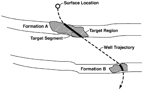
[0011] Fig. 1 shows an example of targeted areas in a reservoir in the
present inventive
method;
[0012] Fig. 2 shows a drill center with three well trajectories passing
through a total of
five Dynamic Target Regions;
[0013] Fig. 3 shows a top view of the drill center and three wells of
Fig. 2;
[0014] Figs. 4A-B show drill center cost contours, several dynamic target
regions
identified, and well trajectories and drill center resulting from optimization
by the present
inventive method;
-3 -
CA 02781868 2012 05 24
WO 2011/096964 PCT/US2010/053139
[0015] Fig. 5 is a flow chart showing basic steps in one embodiment of
the present
inventive method; and
[0016] Fig. 6 is a flow chart showing basic steps in a well trajectory
optimization process
that may be used in the last step of Fig. 6.
[0017] The invention will be described in connection with example
embodiments. To the
extent that the following description is specific to a particular embodiment
or a particular use
of the invention, this is intended to be illustrative only, and is not to be
construed as limiting
the scope of the invention. On the contrary, it is intended to cover all
alternatives,
modifications and equivalents that may be included within the scope of the
invention, as
defined by the appended claims.
DETAILED DESCRIPTION OF EXAMPLE EMBODIMENTS
[0018] The present invention is a method for facilitating the well
planning and screening
process by creating more flexible regions of target definition and/or a bottom-
up approach
focus on productivity of well segments within the reservoirs. The inventive
method can also
be used in an interactive environment in which the user can rapidly evaluate
alternative drill
center locations and well trajectories on the basis of geological as well as
engineering
constraints.
[0019] The focus of the inventive method is on utilizing flexible regions
of interests in
the reservoirs for the purpose of satisfying multi-well constraints to derive
optimal drill
center configuration. The inventive method also provides rapid, multi-
disciplinary evaluation
of many alterative scenarios. The inventive method enables greater value
capture by bringing
the decision making and technical analysis together for rapid execution and
scenario analysis.
[0020] The present inventive method allows the user to obtain optimal
drilling
configurations in which constraints such as boundaries or regions of targeted
locations in the
reservoirs, maximum well spacing, maximum dogleg severities of well
trajectories, can be
set while minimizing total cost and/or maximizing reservoir productivity.
[0021] Basic steps in one embodiment of the invention are shown in the
flow chart of Fig.
5. In step 51, a shared earth model is created that includes geological
interpretation (e.g.
horizons and faults), seismic data, and well data. Preferably, the earth model
is a three-
dimensional representation of one or more potential reservoirs; geological and
engineering
objects such as fault surfaces and salt bodies can also be defined in the
model for object
avoidance.
- 4 -
CA 02781868 2012 05 24
WO 2011/096964 PCT/US2010/053139
[0022] In step 52, an earth property model is created that extends from
the seafloor (or
land surface) to below possible well total depth locations (sufficiently below
the target
reservoir interval(s) to accommodate "rat hole"). Properties within the model
may include,
for example, pore pressure, fracture gradient, temperature, lithology
(sand/shale), and stress
orientation and magnitude. These properties may be calculated or derived using
any of
several methods, including, but not limited to, (1) predictive equations based
on measured or
inferred gradients, offset well information, and lithology estimates; (2)
derived from 3D
seismic data or other volumetric properties (e.g. impedance); or (3)
interpolated from offset
wells. Properties may be pre-calculated and stored in a 3D data volume and/or
in some cases
calculated as needed "on the fly." Properties for the model may be generated
using, for
example, existing computer processes or programs such as geological model
analysis or
reservoir simulators for property modeling and engineering programs such as
the
commercially available product GOCAD for well path calculation.
[0023] In step 53, dynamic target regions ("DTRs") are identified.
Dynamic target
regions are areas (or volumes in a 3D model) defined within the shared earth
model based on
geoscience and/or reservoir engineering criteria (e.g. reservoir sweet spots,
or well locations
optimized through reservoir simulation). Other factors, such as drainage
boundaries, may be
relevant for determining the extent of a DTR. Alternatively, a DTR may be
defined based on
a set of 3D geo-bodies based on seismic data using connectivity analysis such
as is described
in U.S. Patent No. 6,823,266 to Czemuszenko et al. Among other alternatives,
DTR could be
defined as a set of bounding polygons in stratigraphic surfaces of reservoirs.
Instead of a
point location as in the traditional practice and methods, the present
inventive method uses
finite-sized DTRs and allows many possible path segments to be selected and
constrained by
them. The shape and size of a DTR can be defined by geoscientists to cover the
area of
interest that the well trajectory should pass through. For example, the area
of a DTR for a
producing well would be to cover the high permeability rock in the reservoir
which would
yield more oil/gas extraction. Other tools such as connectivity analysis
program mentioned
earlier can also be used to help determining the size and shape of DTR. In a
highly
connected reservoir, a DTR could be as big as a detected geo-body based on a
low threshold
connectivity criteria since the extraction of oil/gas from the planned well
path would depend
less on the location within the geo-body. On the other hand, in a highly
fragmented reservoir,
the well path needs to penetrate a narrowly defined area. Other factors, such
as uncertainty of
the interpreted reservoir geometry or uncertainty of the reservoir properties
can also affect the
-5 -
CA 02781868 2012 05 24
WO 2011/096964 PCT/US2010/053139
size and shape of the DTR. The DTR is preferably defined to be as large as
possible without
compromising the criteria used to define eligibility.
[0024] As with the point targets in traditional practice, each DTR
requires that a well path
passes through it. In some embodiments of the invention, the initial focus is
on determining a
path segment (called target segment) within each DTR before determining the
entire well
trajectory from a surface location to the DTR. (Terms such as well trajectory
and well path
or drill path are used essentially interchangeably herein.) A target segment
is a desired
pathway within a DTR based on its potential to be a partial segment of a well
trajectory. The
determination of the location and geometry (or shape) of a target segment
would focus on the
effect on production performance in terms of geological setting including
factors such as
lithology and connectivity. That is, a desired target segment within the DTR
could be
determined first based mainly on the rock properties and with less concern
about the cost of
building such a well path segment. The initial target segment can then be
modified if
necessary to another position or geometrical shape in order to accommodate,
for example,
other well trajectories for a given drill center location. The finite size of
the DTR gives the
user flexibility to select an initial target segment that will likely speed
convergence of the
well path optimization program.
[0025] In step 54, constraints are defined on well paths, inter-well
distances, and/or drill
center. Well path constraints may be based anti-collision criteria on given
geological objects
such as faults, to avoid being too close to fault surfaces. Another anti-
collision constraint is to
disallow any two well trajectories that come closer to each other than some
pre-selected
minimum distance. Constraint conditions such as reservoir quality (porosity),
minimum total
measured depth, accumulated dogleg angle, distances for anti-collision and/or
potential area
for the drill center location can be predefined or chosen by the user. The
constraints are
determined just as in traditional well path optimization, and therefore the
person skilled in the
technical field will understand how to perform step 54.
[0026] Basic trajectory parameters (e.g. dog-leg severity, kick-off
depth, hold distances
and trajectory type) are selected by the geoscientist and/or drilling
engineer, and a well path
connecting the one or more selected DTRs via target segments may be created.
The
geometry and location of the target segments within the DTRs are modified if
necessary; see
step 63 in Fig. 6. The modification of the target segments in some cases could
yield a lesser
producible well path within each DTR, but the flexibility of allowing such
modifications can
- 6 -
CA 02781868 2012 05 24
WO 2011/096964 PCT/US2010/053139
yield a better overall cost of, and benefits from, the selected drill center
location and its
associated well path or paths.
[0027] Optionally, the user could also impose inter-well constraints such
as well-to-well
distance functions along the potential well trajectories. Optionally, the user
could also impose
drill center constraints, i.e. parts of the surface area to be avoided as
unsuitable for the drill
center.
[0028] In step 55 of Fig. 5, optimization processing is used to derive an
optimal drill
center location and a set of well trajectories to reach the DTRs identified in
step 53 and
satisfy the objectives and constraints imposed on step 54. Detail of this step
for one
embodiment of the invention is outlined in the flow chart of Fig. 6. What is
outlined in Fig. 6
is currently standard drill path and drill center optimization procedure in
well drilling design
except that the traditional constraint that the drill path must pass through a
point is replaced
by relaxing the point constraint to anywhere in a finite (non-infinitesimal)
region.
[0029] Figure 6 describes an embodiment of the invention in which the
user selects an
initial target segment through each DTR before the optimization process
begins. Thus, at
step 61, an initial well trajectory segment, sometimes referred to herein as a
target segment, is
determined within each DTR. The selected target segments are used as initial
choices that
may be varied in the optimization process. Also at step 61, an initial drill
center location that
satisfies any surface area constraints is identified. The design of the drill
center includes
enough slots to accommodate the number of well trajectories that may be
created. Also at
step 61, one or more (depending on the number of DTRs) well trajectories are
created using,
for example, one of several existing well path creation algorithms such as
GOCAD, starting
from a slot or slots in the drill center. The generated slot configurations
also allow the
optimization process to apply on each well trajectory, so the optimal slot
allocation can also
be determined; such a result is shown on Fig. 3, which shows a drill center
with six slots,
three of which are used to reach five DTRs. The well creation algorithms will
yield a
drillable well path based on the selected engineering constraints such as
maximum dogleg
severities. Each well trajectory is defined so as to reach one or more DTRs by
connecting the
initially selected target segments.
[0030] As the well path is being created, earth property information may be
automatically
extracted or calculated along the well path from the earth model. These
properties may be
displayed along the well bore in numerous ways including: by coloring the well
path object,
- 7 -
CA 02781868 2012 05 24
WO 2011/096964 PCT/US2010/053139
pseudo-log type displays, or 2-D plots linked to the well path (e.g. pore
pressure, fracture
gradient profiles).
[0031] In this mode, the extracted properties can be used to quickly
screen or evaluate
(step 62) a possible well path scenario. The cost of drilling such a well path
can also be
estimated since the total measured depth and the curvature of the path are
known. Using this
approach, well path and design scenarios can be rapidly generated and screened
efficiently.
[0032] If one of the well trajectories cannot be generated or the
generated trajectory does
not meet the imposed constraints (for example, non-drillable well path, too
close to a salt
dome), the corresponding trajectory segment(s) can be adjusted within the
corresponding one
or more DTRs or another optimization variable can be adjusted (step 65). The
evaluation of
step 62 is then repeated at step 66. This process may be implemented as a sub-
task of
optimization of a single well path based on the given surface location and
sequence of DTRs.
The sub-task would allow an alternate optimal well trajectory be generated to
meet the
imposed constraints.
[0033] Available well-path generation products follow certain predefined
methods (such
as Continue Curve To the Target, Hold Some Length and Correct To the Target in
a
Specified Direction, etc.) in order to maintain smooth transition while
drilling. Typically,
each path consists of a sequence of straight and curved segments. The straight
segments cost
less to drill and the curved sections are necessary for the transition from
one azimuth
direction to another in order to reach deviated locations. Most of the
existing path generation
programs are deterministic based on a set of constrains given by engineers,
but optimization
algorithms may also be used to derive better solutions. Any well path
generation method is
within the scope of the present invention as long as it allows for a finite-
size target region.
[0034] At step 63, the optimization process then evaluates a total
"goodness" measure,
typically called an objective function or cost function, for the current
combination of drill
center location, slot allocation and well path(s). The objective function is a
mathematically
defined quantity that can be calculated for each proposed drill path and that
is constructed to
be a quantitative measure of the goodness of the trajectory.
[0035] An objective function is a function of certain selected
measurements. One such
measurement is the total measured depth of all the well trajectories. This
measurement is
obviously related to the cost of constructing the proposed wells (the longer
the path, the
higher the cost). Other measurements such as total dogleg angles and Drill
Difficulty Index
- 8 -
CA 02781868 2012 05 24
WO 2011/096964 PCT/US2010/053139
would also relate to the cost (it costs more to drill a highly curved well
trajectory). Other
measurements may relate to the rewards, i.e. economic payoff, of a successful
drilling
operation. One way to measure that is to calculate how much of a well
trajectory penetrates
to the high porosity areas and/or highly connected reservoir regions. Step 63
is the same as in
traditional well path optimization methods.
[0036] At step 64, the computed measure of goodness is compared to a user-
set criterion.
Thus, the value of the objective function for the current combination of drill
center location
and drill path(s) is compared to a desired value. If the criterion is
satisfied, the process of
Fig. 6 is finished. If it is not satisfied, and no other stopping condition
applies, then as in
traditional methods the process is repeated with the previous drill center
location adjusted at
step 67. ((Step 67 may also be reached if an evaluation at step 66 is
negative.) This cycle
repeats until the process is stopped at step 64, and in this way an optimal
drill center location
is obtained or a suboptimal location that satisfies user-defined objectives is
reached. The
method of selecting a new drill center location for each iteration may be
highly dependent on
the mathematical functions of the optimization algorithms. For example, a
stochastic
method, similar to the one described in the paper "Simplifying Multi-objective
Optimization
Using Genetic Algorithms," by Reed et al., in Proceedings of World Water and
Environmental Resources Congress (2003) would randomly select a new location
based on
the past iterations by permutation of certain parameters. Other deterministic
algorithms would
try a new location based on the calculated converging path. All such methods
are within the
scope of the present invention.
[0037] A goal of the present inventive method is to minimize the total
cost of building
and operating drill centers and associated wells and to maximize the benefits
and rewards of
such a drill configuration. The above-described optimization step 55 is an
example of
"Multi-Objective Optimization," a known method (except for the role of the
DTRs)
employed in some embodiments of the present invention. In general, this method
involves
optimizing two or more conflicting objectives subject to given constraints.
Example Applications of the Present Inventive Method
[0038] The following are examples of how the invention may be
implemented.
Example 1: Drill center planning and well path optimization based on user
defined polygonal
area in the reservoir.
- 9 -
CA 02781868 2012 05 24
WO 2011/096964 PCT/US2010/053139
[0039]
Data input: A set of six polygonal areas R(i), identified as Dynamic Target
Regions from reservoir properties such as amplitude mapping on the top surface
of the
reservoirs. For each R(i), a well trajectory is expected to be derived based
on user preference
parameters such as build length and dog-leg angle criteria. This example needs
only a simple
cost function based on the total measured length of the entire well with fixed
dollars per feet.
The drill center is designed with 6 slots and each slot would host the start
of a well trajectory
to reach one of the proposed DTRs. The location of the drill center is
constrained to a
specified rectangular surface area (41 in Fig. 4A).
[0040]
Objective function: Find an optimal drill center location with optimal defined
by
the following:
Minimize total cost of drilling well trajectories ¨ 1 MD(i) for i = 1 to N,
where N = 6 is the number of well trajectories; and
MD(i) is total measured depth of i-th well trajectory;
subject to:
1) each well trajectory passes through somewhere in the interior of a
corresponding
Dynamic Target Region; and
2) each well trajectory satisfies user preference parameters within some
specified
tolerance.
[0041]
Figures 4A-B show the results of optimization by the present inventive method,
with DTRs shown in Fig. 4A, and cost contours shown in Fig. 4B on the surface
area 41
designated for possible drill center location.
Example 2: Drill center planning and well path optimization using
engineering/reservoir
properties as proxy.
[0042]
Data input: A set of volumetric defined regions VR(i), identified as Dynamic
Target Regions from the reservoir properties such as amplitude attributes on a
3D seismic
data volume. For each VR(i), a well trajectory is derived based on the user
preference
parameters described in Example 1. Additionally, a set of geological
constraints such as
distance to fault surfaces, salt domes are imposed. The conditions of anti-
collision to the
geological objects can be determined by the geometric distance calculations
and/or by
calculated proxy volumes encompassing the 3D earth model where each voxel
contains
information on the relationship to the closest geological objects. To maximize
the total
"reward" of well trajectories with Target Segments penetrating the VR(i), the
reward value
can be determined by the total accumulated value within the defined region
and/or by other
- 10 -
CA 02781868 2012 05 24
WO 2011/096964 PCT/US2010/053139
performance measurements. The cost of drilling is also represented by 3D
volumetric data.
In this data volume, cost values are imbedded in each voxel representing the
cost of well
segments passing through the cell location. The cost estimations for each cell
may be derived
from parameters such as drilling difficulty index, rock type in the cell
location, as well as
geological and geophysical properties.
[0043] Objective function: Find an optimal drill center location such
that
Minimize: 1 COST(i) for i = 1 to N; and
Maximize: 1 REWARD(i) for i = 1 to N
where: N is the number of well trajectories.
COST(i) is total cost of the i-th well trajectory; and
REWARD (i) is total performance measurement of i-th well trajectory;
subject to:
1) each well trajectory passes through the interior of the corresponding
Dynamic
Target Region;
2) each well trajectory satisfies user preference parameters within some
specified
tolerance; and
3) each well trajectory satisfies user-imposed anti-collision constraints.
[0044] The foregoing description is directed to particular embodiments of
the present
invention for the purpose of illustrating it. It will be apparent, however, to
one skilled in the
art, that many modifications and variations to the embodiments described
herein are possible.
All such modifications and variations are intended to be within the scope of
the present
invention, as defined in the appended claims.
- 11 -