Note: Descriptions are shown in the official language in which they were submitted.
CA 02784081 2012-06-12
Geolocation system and method hybridizing a satellite navigation
system and a data collection system
The present invention firstly concerns a geolocation system
employing hybridization of a satellite navigation system and a data collection
system.
In particular, the present invention provides for combining some of
the signais from a satellite navigation system with measurement elements
effected by a data collection system with the aim of determining the precise
geographical location of an object, quickly and economically from an energy
point of view.
One objective of the invention is to maximize the autonomy of the
claimed geolocation system by minimizing acquisition and processing
operations effected by means situated on the object to be located. According
to the invention, as many operations as possible are effected by remote
elements belonging to the data collection system.
Numerous data collection systems are now used for diverse
purposes: study of fauna, the environment, ship distress beacons, maritime
traffic surveillance systems, etc. The Argos system, which has been in
operation since 1979, is one well known example. However, there exist other
data collection systems such as the AIS (Automatic Identification System)
and the SAR (Search And Rescue) system, for example. The general
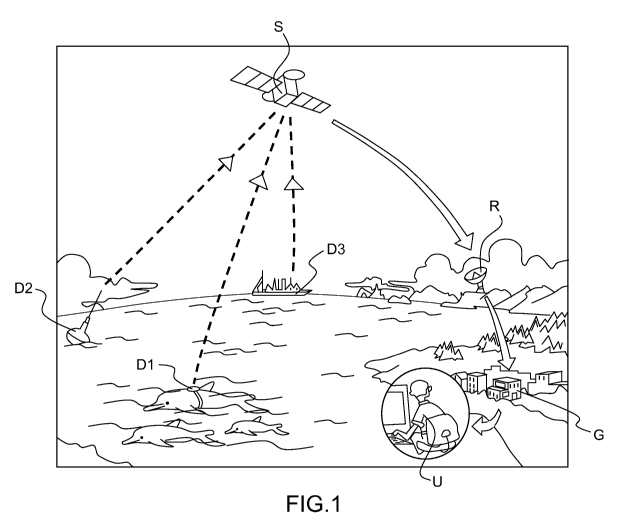
operating principle of a data collection system is represented in Figure 1.
Thus, in the Figure 1 diagram, data collection devices equip an
animal population Dl, meteorological buoys D2 or a fleet of fishing boats D3,
for example. The measurements effected by these devices are encapsulated
in messages sent via appropriate transmitter devices to satellites S. Said
satellites S relay these messages, possibly modified and possibly
accompanied by measurements of the received signal, to receiver stations R
on the ground. These forward the messages to ground stations G that have
appropriate processing means, for example enabling approximate location of
the objects under study or surveillance. After processing of the messages
transmitted by the satellites S and the receiving stations R, the ground
stations G can send information messages to a user network U_ However,
the geolocation of an object by a data collection system alone is insufficient
CA 02784081 2012-06-12
2
because it is too inaccurate. The accuracy of such systems is oniy 300 to 500
metres, because of their intrinsic defects, and notably insufficiently
accurate
internai clocks and the small number of measurements.
Moreover, it is known that to determine the position of an object on
the surface of the Earth it is possible to use the capabilities of a Global
Navigation Satellite System (GNSS) such as the Global Positioning System
(GPS), the Glonass system or, soon, the Galileo system. To implement a
satellite navigation system it is necessary to equip the object to be located
with means for acquisition of signais transmitted by the satellites of the
navigation system. Those signais must be decoded by means associated
with the aforementioned acquisition means in order to calculate the position
of the object. Those means consist in a receiver or a beacon such as a GPS
receiver or a GPS beacon.
The use of such geolocation means has a number of drawbacks.
Firstly, geolocation by a satellite navigation system implies
decoding signais coming from said satellite navigation system, such as the
GPS. The decoding of a complete GPS signal can take approximately
30 seconds to one minute for the calculation of a first point. During those
30 seconds, the GPS beacon used to acquire and decode the GPS signal,
and installed on the object to be geolocated, is powered up, which affects the
autonomy of said GPS beacon. Moreover, during those 30 seconds to one
minute, there must be a clear sky and to be more precise a sufficient number
of - at least 4 - satellites visible. This is virtually impossible when the
aim is
to track a population of amphibious animais.
Moreover, for this type of system to be able to geolocate an object,
the entirety of the GPS signal must be readabie. If, because of poor reception
quality, part of the GPS signal is lacking, no geolocation is possible. This
drawback is reflected in a sensitivity (i.e. a reception capacity) that is
potentially insufficient in geolocation systems using a satellite navigation
system.
To alleviate these problems, some systems currently being
developed are leading to the design of beacons, for example GPS signal
receivers, that digitize said GPS signais without processing them and forward
them to satellites in order for the geolocation calculation to be effected by
external means, typically one or more ground stations. This solution has two
CA 02784081 2012-06-12
3
serious disadvantages, however: firstly, it implies a high uplink data rate
because all of the GPS signal is relayed; secondly, according to this
solution,
the object to be tracked or under surveillance, and in any event to be
geolocated, does not know its position.
Accordingly, a first objective of the present invention is to improve
the performance of geolocation systems, notably in terms of sensitivity.
Another objective of the invention is to enable simplification of the
receiving
means equipping the objects to be geolocated, notably with a view to
minimizing their energy consumption and, consequently, to increasing their
autonomy. To achieve these objectives, the present invention does not imply
any significant increase in the data rate of the uplink to the satellites S.
To this end, the invention consists in a method of geolocation of
an equipment, comprising the following steps:
^ reception by receiving means situated on said equipment of positioning
information coming from a satellite navigation system, said positioning
information containing at least one code phase measurement;
^ transmission of messages, by transmission means situated on the
equipment and belonging to a data collection system, said messages
containing said code phase measurements, and measurements on the
transmission of the messages, effected by measuring means belonging to
said data collection system;
^ combination by processing means remote from the equipment and
belonging to said data collection system of said code phase
measurements and said measurements on the transmission of the
messages, in such a manner as to geolocate said equipment.
Said measurements on the transmission of the messages
preferably contain a measurement of the date and time of reception by relay
means remote from the equipment of the messages transmitted by the
transmission means of said data collection system.
The method of the invention may advantageously comprise the
combination of said measurement of the date and time of reception and a
date and time of transmission of said message by the transmission means in
such a manner as to calculate the propagation distance between the
equipment and the relay means of the data collection system.
CA 02784081 2012-06-12
4
In one embodiment of the method the date and time of
transmission of said message by the transmission means are determined by
a resolution of ambiguity based on the possible propagation distances
between the equipment and the relay means of the data collection system,
given the position of said relay means at the moment of reception of said
message.
The determination of said transmission date and time may
advantageously utilize an estimate of the time elapsed between the
production of the code phase measurements and the transmission of the
message via the data collection system to reduce the ambiguity resolution
domain.
Said measurements on the transmission of the messages
advantageously contain a Doppler measurement, i.e. a measurement of the
difference between the frequency at which the messages are transmitted by
the transmission means and the frequency at which said messages are
received by the relay means of the system for collecting those same
messages.
The method of the invention may advantageously include a step of
determination of the absolute position of the satellite or satellites of the
satellite navigation system originating said positioning information,
comprising the association of said code phase measurements with an
identifier characteristic of the satellite that sent said positioning
information
concerned, said identifier enabling determination of the absolute position of
the satellite or satellites of the satellite navigation system by consultation
of
the ephemerides relating to the satellite navigation system concerned.
The method of the invention may advantageously include a step of
determination of the absolute position of the satellite or satellites of the
satellite navigation system originating said positioning information,
comprising the resolution of the position of one or more satellites by
comparison of a set of possible positions determined as a function of the
ephemerides of the satellite navigation system concerned with geolocation
information specific to said data collection system.
According to the invention, a system for geolocation of an
equipment may comprise means situated on said equipment for receiving
positioning information from a satellite navigation system, said positioning
CA 02784081 2012-06-12
information containing at least one code phase measurement, and
transmission means, situated on said equipment and belonging to a data
collection system, for sending messages containing said code phase
measurements and measurements on the transmission of the messages
5 effected by measurement means belonging to said data collection system,
and be adapted to implement the method according to the invention as
defined above.
Such a geolocation system may advantageously comprise relay
means and processing means remote from said equipment and belonging to
said data collection system, respectiveiy comprising a network of satellites
and a network of ground stations.
The equipment advantageously supplies current to said
positioning information receiving means only during a time period necessary
and sufficient to effect said code phase measurements on the signais coming
from the satellite navigation system.
The system according to the invention may advantageously return
to the equipment a message including its geolocation.
In one embodiment the system according to the invention
broadcasts continuously to a network of users the absolute time provided by
the satellite navigation system.
Other features and advantages of the invention will become
apparent in the light of the following description given with reference to the
single appended drawing, Figure 1, which represents the operating principle
of a data collection system.
Figure 1 is a diagram used to describe a prior art data collection
system. This diagram may also serve to describe the invention.
The general operating principle of a prior art data collection
system has already been briefly outlined in the introduction.
As also described hereinabove, known geolocation systems
enable relatively accurate location of any object situated on the surface of
the
Earth equipped with a beacon able to decode the signais transmitted by
satellites of the satellite navigation system concerned. As has been
explained, these systems have the main drawbacks of necessitating a long
decoding and processing time by the beacon onboard the subject to be
located, and having a low sensitivity.
CA 02784081 2012-06-12
6
The basic principle of the invention consists in hybridizing a data
collection system and a satellite navigation system. In other words, in
accordance with the invention, the objects Dl, D2, D3 to be located include
not oniy beacons equipped with means for effecting measurements,
belonging to the data collection system and beacons adapted to receive
signais from satellites belonging to a satellite navigation system, but also
and
above ail the means of the data collection system and the means for
receiving signais from satellites belonging to a satellite navigation system
are
adapted to cooperate with a view to providing an accurate geolocation of said
objects quickly, in particular where the calculation of the first point is
concerned.
To this end, the system of the invention is designed so that as little
processing as possible is effected by the means equipping the objects to be
located. In particular, according to the invention, the means for receiving
the
signais from the satellite navigation system do not need to decode in their
entirety signais, referred to in the remainder of the present description as
positioning information, coming from the satellite navigation system. Most
satellite navigation systems, namely the GPS and the Galiléo system,
transmit signais including a field usually called the code phase,
corresponding to an extremely regular clock pulse, on which the positioning
signal is sent. It is not a date and time, or a "GPS time", but only a pulse.
The
GPS and the Galiléo system transmit signais including a code phase type
field or its equivalent.
According to the invention, the means for receiving positioning
information may acquire oniy the code phase inciuded in said positioning
information. To determine thereafter the "GPS time" and the position of the
satellites of the satellite navigation system that sent the positioning
information, the system of the invention then functions in "masked time", i.e.
it is not the means for receiving the positioning information that
participate,
but means of the data collection system, and in particular means hosted by
one or more ground stations G. Knowing the code phase, positioning
consists oniy in resolving the ambiguity of this measurement, the magnitude
of resolving the ambiguity depending on the length of the code on which the
phase measurement is effected. Depending on the satellite positioning
CA 02784081 2012-06-12
7
system used, this ambiguity may be 1 millisecond, 4 milliseconds or
milliseconds.
To resolve this ambiguity, said means hosted by one or more
ground stations G combine the code phase read in the positioning
5 information with data coming from the data collection system. These means
thus constitute means for combining said code phases and information
corresponding to portions of messages containing measurements effected for
the data collection system via beacons including measuring instruments and
means for transmitting messages containing the measurements to satellites
10 S. As already explained, these satellites S establish the link between the
objects to be located, tracked or studied and a network of ground stations by
relaying the messages containing the measurements to said ground stations
G via receiving means R.
As is known in the art, to geolocate an object, it suffices to know
the position of the satellites of the satellite navigation system concerned,
positioning information from which has been received by the object to be
geolocated, and the universal time of these signais, typically the "GPS time".
To achieve this, as already stated, the system of the invention has access to
the code phase of the positioning information and messages containing the
measurements transmitted by the means of the data collection system
equipping the object to be geolocated.
There are different ways to implement the invention, depending on
circumstances. To determine the position of the satellites of the satellite
navigation system producing the positioning information, there are at Ieast
the following two possibilities. First of ail, if the code phase is "tagged"
when
it is forwarded to the collection system, i.e. if it includes an identifier
characteristic of the satellite transmitting the positioning signal, it
suffices to
look up this satellite in the ephemerides relating to the satellite navigation
system concerned to determine its position as a function of time. A second
possibility consists in "resolving" the position of the satellites by a
process of
elimination, on the basis of geolocation data intrinsic to the data collection
system. By cross referencing this data with the data from the ephemerides
relating to the satellite navigation system concerned, the position of the
satellites from which the positioning information was received is determined.
CA 02784081 2012-06-12
8
There also exists various methods for determining the universal
time, for example the "GPS time", and these methods may be combined.
In a first case, the object Dl, D2, D3 to be located including
means for effecting measurements and means for transmitting messages
containing the measurements to satellites S is configured so that the date
and time of the measurement, corresponding to a date and time determined
as a function of an internat clock situated on the object to be located, is
included in the message containing the measurements. The satellites S
knowing the universal time, for example the "GPS time", it is then possible to
work back to the universal time as seen by the object Dl, D2, D3 to be
located; it suffices to determine the propagation time of the messages
containing the measurements from the object Dl, D2, D3 to be located to the
satellites S, with an accuracy better than the residual ambiguity of the code
phase measurement.
In a second case, if the messages containing the measurements
sent to the satellites S do not include a date and time of the measurements,
it
is possible to resolve the universal time seen by the object Dl, D2, D3 to be
located by analyzing the possibilities, code phase by code phase, in a time
interval typically of 10 seconds preceding the date and time of reception of
the message containing the measurements by postulating that the measuring
means of the data collection system and the associated transmission means
equipping the object Dl, D2, D3 to be located have not taken more than 10
seconds to send a message containing the measurements and the code
phase starting from the time at which the means receiving positioning
information for the object Dl, D2, D3 to be located to have received a
positioning signal for which they have acquired said code phase.
In any event, if there is any ambiguity, or to verify the validity of the
calculation, the invention may comprise a step of Doppler measurement of
the frequency shift between the transmission of the message containing the
measurements and its reception by the satellite S. This measurement
enables the object to be geolocated to be situated on a spherical hyperboloid
centred on the satellite S and the characteristic of which is given by the
Doppler measurement.
It should be noted that, in the conventional way, if a plurality of
satellites of the satellite navigation system are visible from the object to
be
CA 02784081 2012-06-12
9
geolocated, a triangulation method may be used. Thus there is no ambiguity
as to the position of the object to be geolocated using four visible
satellites of
the satellite navigation system. With fewer than four satellites visible, it
is
possible for example to use the method explained above of Doppler
measurement by measurement of the collection signal, and thus replacement
of a satellite of the satellite navigation system by a satellite of the
collection
system to establish the point, i.e. to geolocate the object.
To summarize, the main advantage of the invention is to enable
accurate geolocation of objects by coupling a data collection system with a
satellite navigation system. The system of the invention necessitates a
minimum processing time by the means equipping said objects, given the
processing effected in "masked time" by remote equipment, typically ground
stations of the data collection system. To this end, the system of the
invention notably necessitates only acquisition of the code phase of the
positioning information coming from the satellites of the satellite navigation
system. Acquisition of the code phase classically necessitates only around
one millisecond of processing time. Compared to the more than 30 seconds
that GPS receivers currently take to acquire the GPS signais, decode the
GPS time and consuit the ephemerides, the energy savings and thus the
improvement in autonomy for these systems is evident. In the system of the
invention, the complex processing and notably the determination of the
universal time as seen by the objects to be geolocated are effected by
remote means such as the ground stations of the data collection system.
It may be noted that the system of the invention may optionally
include means for sending their position to the objects to be geolocated once
it has been calculated. The system of the invention may also include means
for broadcasting data to a network of users, for example the universal time
such as the GPS time.