Note: Descriptions are shown in the official language in which they were submitted.
CA 02786407 2016-12-13
27371-206
- 1 -
METHOD AND SYSTEM FOR SENSING THE POSITION OF A VEHICLE
FIELD
The invention concerns a method and a system for purposes of
registering the_position of a vehicle in a defined region.
BACKGROUND
The regisnring of the current position of a vehicle in a
defined region is of great importance in a very wide range of
applications. For example the determination of the positions of
industrial goods-handling vehicles (e.g. forklift trucks) in the
field of storage logistics (management of e.g. production
stores, distribution stores) is of great importance, since by
this means, for example, the optimisation of logistical proc-
esses and automatic tracing of batches of goods items is made
possible. For this purpose a very wide variety of methods and
devices are of known art, wherein in particular it is of known
art to register an abSolute reference position of the vehicle,
and also the relative movement of the vehicle, and thus to de-
termine the current position of the vehicle, with the aid of a
dead reckoning navigation system.
From DE 102 34 730 Al a method for determining the position
of a transport vehicle within an effective range is of known
art, =in which moveable first objects, transported by the trans-
port vehicle, (transport units, pallet cages, beverage crates or
similar) and stationary second objects (for example, walls, sup-
porting pillars) are present. The effective range is stored in
the form of a digital map, which contains the positions of the
objects. The forklift truck has a laser radar (=LADAR), an elec-
tronic compass, and a kinematic GPS, connected with an on-board
computer, which supply data to the on-board computer. For pur-
poses of determining the position of the forklift truck the
LADAR scans a contour of the environment and thereby registers
the warehouse goods items located in the immediate environment,
whereupon the result of this scan is compared with the digital
map stored in a central computer; on the basis of this compari-
son the on-board computer or the central computer can determine
a position of the forklift truck within the effective range. The
LADAR also registers the separation distance between the fork-
lift truck and the known objects, in order to generate an image
of the forklift truck's environment. From the determined meas-
urements the position of the forklift truck is determined by a
comparison with the data of the digital map using trigonometri-
cal calculations and methods. For purposes of improving the de-
CA 02786407 2012-07-05
- 2 -
,
termination of position, data for moveable third objects can
also be held in the digital map; these are registered during the
scan and are used to update the database. These third objects
can be other transport vehicles and/or unknown obstacles.
Disadvantageously the objects called upon for purposes of
registering position must have a measurable contour so as to en-
able a determination of position by way of the laser scanning
procedure. Therefore identical objects (e.g. supporting pillars,
Euro-pallets, etc) cannot be uniquely identified. Moreover in
accordance with DE 102 34 730 Al it is necessary to determine
differences between the scans made by the vehicle and the cen-
trally managed map so as to determine from these the exact posi-
tion. This means that an exact determination of absolute posi-
tion is not possible, instead a probable position is determined
by way of an exclusion method; while in the best-case scenario
this does indeed correspond to the actual absolute position, it
can also deviate significantly from the latter. The determina-
tion of position by means of laser radar scanning in accordance
with known art encounters its limitations in particular if the
environment is similar or the distances involved prevent or
place limits on the scanning procedure (e.g. in the case of an
empty warehouse with supporting pillars, with empty storage ar-
eas, or storage areas with stored goods items that have identi-
cal structures, or in the external environment).
From US 2009/0198371 Al a system for goods items tracking is
furthermore of known art, with a fixed base system and mobile
systems that are linked with vehicles. The mobile system has an
identification sensor for purposes of registering objects with
coding. The monitored space is also fitted with position markers
that are individually different; these are arranged in the ceil-
ing region. The vehicle has an optical position sensor device
with a camera that is upwards directed; this records images of
the environment so as to register position markers present in
the visual field and to establish their identities. The posi-
tions of the position markers in the recorded image are used to
register the position and the angular orientation of the vehi-
cle. When a position marker is registered the database in the
memory of a mobile computer system on the vehicle is also up-
dated. However, this system has the disadvantage that no deter-
mination of position is possible if there is no marker in the
CA 02786407 2012-07-05
- 3 -
field of view of the camera, i.e. no other system is available
to execute a determination of position. Accordingly a marker
must be in the field of view at all locations where a position
is required. In storage depots, however, a registration of posi-
tion is required at all locations and at all times, in order to
track even goods items that are set down in unscheduled storage
areas. This in turn means that the storage depot must be fitted
with very many markers; this leads to an extremely high level of
expenditure, particularly in the case of large storage depots.
Moreover, by virtue of the attachment of markers to the ceiling,
this system of known art is disadvantageously limited to an in-
ternal environment.
From DE 44 29 016 Al a navigation system for driverless ve-
hicles, in particular for transport systems in workshops, is of
known art, in which high-contrast objects in the environment, in
particular ceiling lights, are recorded by means of an imaging
sensor that moves with the vehicle. From the location of these
ceiling lights the position and angle of orientation of the ve-
hicle are then determined. Through the use of the high-contrast
ceiling lights for the registration of an absolute reference po-
sition the costs of the navigation system are to be kept low.
Apart from the fact that is in actual fact not possible to
differentiate between ceiling lights that are usually of identi-
cal design by way of an optical sensor, e.g. using a CCD camera
or photodiode array, or at best only with a high error rate, a
trailing wheel is provided for purposes of registering the rela-
tive movement of the driverless vehicle; this is connected with
the vehicle via a vertical axis about which it can rotate. From
the angle of rotation of the wheel about its own axis, and from
the angle of rotation of the horizontal movement about the ver-
tical axis, the position of the vehicle is to be determined by
way of dead reckoning navigation. In practice, however, such
trailing wheels have proved to be extremely inaccurate (in par-
ticular as a result of problems with slip and drift).
From WO 01/13192 Al a method and a device for purposes of
registering the position of a vehicle are furthermore of known
art, in which reflecting markers must have been previously fit-
ted on the ceiling of a warehouse; these can be registered by
the vehicle as it drives underneath a marker, so that by this
means a reference position can be registered and stored at this
CA 02786407 2012-07-05
- 4 -
point in time. Moreover in accordance with the WO document a
wheel encoder is provided, which at intervals of time registers
the distance covered by the vehicle; furthermore the angle of
rotation of the vehicle is registered by mean of a gyroscope.
The current position of the vehicle can then be determined by
means of dead reckoning navigation from the reference position
and the relative distance covered, determined by means of vector
addition. What is particularly disadvantageous here is the fact
that the installation of the reflecting markers in the ceiling
region of a warehouse is very labour and cost intensive, and
moreover the registration of the reference position is not al-
ways reliably guaranteed. Furthermore problems arise in the
measurement of the relative movement by means of the wheel en-
coder and gyroscope in terms of slip and drift of the vehicle
(e.g. spinning of the wheels), so that often the relative dis-
tance covered is incorrectly determined. An application of this
method in an external environment (with no roof) of a storage
depot is impossible, or only if linked with substantial instal-
lation and cost expenditures.
In order to eliminate these disadvantages in the registra-
tion of relative movement it is proposed in EP 1 916 504 A2 to
register digital image data of a reference surface area of se-
quential discrete frames, then to subdivide the first of two se-
quential frames into a plurality of macro-blocks, so as to de-
termine these macro-blocks subsequently in the second frame,
wherein the relative movement of the vehicle can be determined
as a function of the movement vectors of the positions of the
macro blocks. By this means the measurement inaccuracies, which
occur during the determination of the relative movement by means
of a wheel encoder and a gyroscope, can indeed be eliminated. As
a result of the fact that the camera must be attached near the
floor, contamination of the camera optics occurs to a large ex-
tent; this can lead to a high level of inaccuracy, or a failure,
in the registration of the relative movement. However, what is
particularly disadvantageous, even in the case of EP 1 916 504,
is the fact that, now as before, for purposes of registering the
absolute reference position a very laborious and cost intensive
installation of reflecting markers in the ceiling region is re-
quired.
A similar method and a similar device for purposes of regis-
CA 02786407 2016-12-13
27371-206
- 5 -
tering a reference position of a vehicle in a warehouse is fur-
thermore of known art from US 2007/10143006 Aa. Here a multi-
plicity of transponders are fitted to the floor of the ware-
house, with the help of which a reference position of the vehi-
cle is then to be determined. Here too this takes the form of a
technically complex system with a multiplicity of sensors,
which, in particular in cases where large surface areas are to
be defined, are the cause of extremely high installation and in-
vestment expenditures. However, what is particuiarly disadvanta-
geous is the fact that the registration of a reference position
of a vehicle is only possible if it drives over a transponder,
and thus there is no continuous registration of a reference po-
sition of a vehicle; this has a particularly disadvantageous
consequence when e.g. =setting down goods items in areas of the
storage depot that are not fitted with transponders.
In DE 103 46 596 Al is likewise proposed the registration of
an absolute reference position with the aid of measurement
strips that have previously been laid down. Furthermore with the
aid of an incremental position registration device a relative
determination of position is undertaken by the vectorial summa-
tion of incremental movement vectors, wherein a parameter is de-
termined for purposes of displaying the quality of the absolute
position registered. As a function of the quality of this pa-
rameter the position of the vehicle in the prescribed region is
outputted either in absolute mode or in incremental mode, i.e.
disadvantageously the absolute and relative measured data are
not merged together; instead the measurement of poorer quality
is totally rejected.
From US 2007/0150111 Al an omni-directional robot is also of
known art, which on its underneath side has a so-called "optical
flow" sensor, with which the relative movement of the robot is
registered. Here, however there is no provision for the regis-
tration of a reference position in a predefined region.
SUMMARY
The objective of the present invention is accordingly to
create a method and a system of the type instanced in the intro-
duction, wherein the installation and investment expenditures
for purposes of registering the position of a vehicle are to be
kept low, at the same time however an accurate and robust deter-
mination of position is guaranteed without the disadvantageous
registration of a pure relative movement of the vehicle, wherein
CA 02786407 2012-07-05
- 6 -
the method and system are to be such that they can be deployed
both in an interior region and also in an exterior region.
In accordance with the invention this is achieved with a
method in which a digital map of the defined region, having a
defined coordinates system, is created, wherein the digital map
includes stationary reference features with a unique identifying
feature, before digital images are recorded of at least a sub-
region of the defined region, preferably of the whole defined
region, for purposes of registering and detecting further refer-
ence features, wherein also stationary and/or temporary refer-
ence features without a unique identifying feature are regis-
tered and detected, and are added to the digital map and/or an
associated buffer store, so that the absolute position of a ve-
hicle in a defined region can subsequently be determined, in
that a digital image of a portion of the defined region is re-
corded by the vehicle, and in the digital image reference fea-
tures are detected and optionally identified, wherein the deter-
mination of absolute position is undertaken on the basis of the
stationary and/or temporary reference features that have been
detected and optionally identified.
The inventive method thus has two stages in time. In a first
step of the method reference features are firstly detected in
the defined environment and the positions of these reference
features are registered on the basis of reference features al-
ready known before the start of the method, and their coordi-
nates are stored in the digital map and/or a buffer store. In a
second stage of the method the absolute position of the vehicle,
i.e. the coordinates pair x, y, that is to say, the orientation
= of the vehicle in the defined environment is then determined in
each case on the basis of the stationary reference features and
any temporary reference features. Thus with the aid of the sta-
tionary and temporary reference features a determination of
relative position, i.e. a pure alteration of position, is not
required and a determination of position based on absolute, i.e.
global, coordinate values can advantageously be executed con-
tinuously. By virtue of the automatic calibration and measure-
ment of reference features complex geodetic measurements can be
avoided, and moreover it is advantageously possible to adapt the
digital map of the defined region in a simple manner in the
event of any alterations or expansions of the defined region
CA 02786407 2012-07-05
- 7 -
(e.g. alterations to the storage areas, expansion of the storage
depot floor area, etc.).
With respect to the types of reference features three types
can in particular hereby be differentiated.
Type 1: Stationary reference features of a fixed design,
with a unique identifying feature, and of variable size.
These possess e.g. a rectangular shape (4 corner points) and
can consist of a black edge, a white surface area, and black
symbols (letters, numbers, or other symbols). The symbol combi-
nation represents a unique identifying feature.
Examples are markings or signage located on the floor, on
walls, or posts (e.g. storage area markings or storage depot
corridor markings). The size of these objects can vary depending
upon the environmental circumstances. Markings in storage areas
can be e.g. 40 x 30 cm in size, markings on storage depot gang-
ways are somewhat larger at e.g. 80 x 60 cm, and signage on
walls or posts can even be e.g. 200 x 150 cm in size.
Type 2: Stationary reference features of a fixed design,
with no unique identifying feature, and of variable size.
These reference features can be any stationary high-contrast
objects in the defined environment (e.g. fire extinguishers,
shelving, posts, etc.). A further example would be a right an-
gle, which is formed by two lines of marking on the floor, which
are located at approx. 90 degrees to one another. These refer-
ence features possess no unique identifying features of their
own (e.g. in the form of a combination of symbols).
Type 3: Stationary reference features of no fixed design,
with no unique identifying features and of variable size.
These reference features are all high-contrast features of
any size and shape (e.g. edges of goods items or labels, con-
tamination on the floor, vehicles, etc.), which are for the most
part only located at one stationary location for a certain pe-
riod of time. These possess no unique identifying features of
their own (e.g. in the form of a combination of symbols).
The digital map of the defined region, i.e. of the defined
environment (e.g. storage depot), possesses a defined (global)
coordinates system, includes the reference features and their
properties (e.g. coordinates, identifying features, etc.) and
can be used for purposes of electronic data processing.
In addition the digital map of the warehouse can include
CA 02786407 2012-07-05
- 8 -
further specific properties of the defined environment (e.g.
global coordinates and dimensions of storage places, etc.).
At the same time as determining the position of the vehicle,
so as to enable also continuous tracking of any goods items
stored in the defined region, it is of advantage if, when set-
ting down goods items having an identifying feature in the de-
fined region, the coordinates of the goods items, preferably the
corner points of the goods items, are added to the buffer store.
Since the goods items that can be uniquely identified by means
of the identifying feature, i.e. in particular a bar code and/or
plain script, e.g. BAN 128, whose coordinates are known, can
similarly be called upon for purposes of absolute determination
of position of the vehicle, and thus determination of position
can be made even more robust and accurate, particularly at those
points where a high level of accuracy is required, it is benefi-
cial if, when detecting an identifying features of an goods
item, and at least one corner point of the goods item by means
of the coordinates held in the buffer store, an absolute deter-
mination of position of the vehicle is undertakn. In addition a
plausibility check of the position can be executed utilising in-
formation concerning the goods items.
In the interests of a particularly robust system it is ac-
cordingly of advantage if the information from a plurality of
absolute determinations of position is used, i.e. in particular
from those determined as a function of the stationary reference
features, and those taking account of temporary reference fea-
tures, and/or determinations of position on the basis of infor-
mation concerning the goods items. Accordingly it is advanta-
geous if a determination of absolute position is undertaken by
means of tracking of stationary reference features, and a deter-
mination of absolute position is undertaken by means of tracking
of temporary reference features and/or the identification of a
goods item, and the absolute position of the vehicle is achieved
by way of a fusion of the coordinates determined by means of the
determinations of absolute position. In this regard it should be
noted that state measurements in principle are always prone to
errors, i.e. in general the measurements do not reproduce the
true state exactly and completely correctly. On the basis of the
measurements it is, however, possible to estimate or approximate
to the exact state. By the fusion of the estimated coordinates
CA 02786407 2012-07-05
- 9 -
from a plurality of determinations of absolute position, by way
of a stochastic method of state estimation in a dynamic process
based on a filter system, e.g. particle filters of known art, a
comprehensive set of rules for the prior knowledge can thus be
stored. With the collection of a large number of samples (parti-
cles) the determination of position thus approximates to the ac-
tual exact value.
With respect to a determination of position on the basis of
a so-called marker tracking it is of advantage if, after re-
cording a digital image for purposes of determining position, at
least one detail from the image, in which at least one station-
ary reference feature is located, is selected and stored, and,
for purposes of absolute determination of position of the vehi-
cle, the detail is projected by means of transformation onto a
subsequently recorded digital image.
In addition, and independently of the tracking of stationary
reference features, it is beneficial if for this purpose a fur-
ther absolute determination of position is undertaken at the
same time by means of three-dimensional features, wherein it is
here advantageous if each reference feature identified in a re-
corded digital image, which is not stored in the digital map, is
preferably buffer stored, and the buffer stored reference fea-
ture is used for purposes of determining absolute position, pro-
vided that the buffer stored reference feature is identified in
a subsequently recorded digital image.
For the further improvement of the accuracy of the determi-
nation of position, i.e. of the robustness of the method for
purposes of determining position, it is beneficial if, when de-
termining the absolute position, sub-regions of the defined re-
gion that cannot be navigated/driven through, or reached, and/or
maximum possible alterations in position within a time period,
are taken into account on the basis of performance data for the
vehicle in combination with a movement history. Here in particu-
lar it can be taken into account that e.g. posts, walls, doors,
shelves, goods items, etc. cannot be navigated or driven through
by the vehicle whose position is to be determined. Similarly
sub-regions can be excluded that the vehicle cannot navigate or
reach by virtue e.g. of its geometry (length, width, height). In
addition a maximum possible alteration in position can be taken
into account as a function of maximum speed, minimum turning
CA 02786407 2016-12-13
27371-206
- 10 -
circle, maximum acceleration/retardation etc., in combination
with the path previously covered, speed, acceleration and
rotation.
The system of the type instanced in the introduction is
characterised in that a memory is provided for purposes of
storing a digital map having a defined coordinates system of
the defined region, wherein the digital map includes stationary
reference features with unique identifying features, and an
imaging sensor device is provided for purposes of registering
and detecting further stationary and/or temporary reference
features without unique identifying features; these are
assigned to the digital map and/or an associated buffer store,
wherein the imaging sensor device is provided moreover for
purposes of registering a digital image of a portion of the
defined region, and for purposes of detecting and optionally
identifying the reference features held in the digital image,
so that a determination of absolute position of a vehicle
provided with the imaging sensor device is undertaken on the
basis of the stationary and/or temporary reference features
that have been detected and optionally identified.
In some embodiments, there is provided a method for
registering the position of a vehicle in a defined region,
wherein a digital map of the defined region is created, having
a defined coordinates system, wherein the digital map includes
stationary reference features with a unique identifying
feature, before digital images are recorded of at least a sub-
region of the defined region, for purposes of registering and
detecting further reference features, wherein at least one of
CA 02786407 2016-12-13
27371-206
- 10a -
stationary and temporary reference features without unique
identifying features are also registered and detected, and are
added to at least one of the digital map and an associated
buffer store, so that the absolute positon of the vehicle in
the defined region can subsequently be determined, wherein a
digital image of a portion of the defined region is recorded by
the vehicle, and wherein the digital image reference features
are detected, wherein the determination of absolute positon is
undertaken on the basis of the at least one of the stationary
and temporary reference features that have been detected.
In some embodiments, there is provided a system for
registering the position of a vehicle in a defined region,
wherein, a memory for purposes of storing a digital map having
a defined coordinates system of the defined region is provided,
wherein the digital map includes stationary reference features
with a unique identifying feature, and an imaging sensor device
is provided for purposes of registering and detecting at least
one of further stationary and temporary reference features with
or without unique identification features, which are assigned
to at least one of the digital map and an associated buffer
store, wherein the imaging sensor device is moreover provided
for purposes of registering a digital image of a portion of the
defined region, and for purposes of detecting the reference
features held in the digital image, so that a determination of
absolute position of a vehicle provided with the imaging sensor
device is undertaken on the basis of the detected at least one
of stationary and temporary reference features.
The advantageous effects that accompany the inventive
device have already been described above in the context of the
CA 02786407 2016-12-13
27371-206
- 10b -
inventive method, so that for purposes of avoiding repetition
reference is made to the above statement.
BRIEF DESCRIPTION OF THE DRAWINGS
In what follows the invention is described in more detail
with the aid of a preferred example of embodiment represented
in the drawing, but it is not to be limited to this example of
embodiment. In particular:
Fig. 1 shows a view in perspective of an industrial
goods-handling vehicle with an imaging sensor device;
Fig. 2 shows another view in perspective of the
industrial goods-handling vehicle in Figure 1;
Fig. 3 shows a storage depot having a multiplicity of
storage areas with different reference features;
Fig. 4 shows schematically a view in perspective of a
goods item located in the storage depot;
Fig. 5 shows a flow diagram of the two steps of a method
for purposes of registering the position of the vehicle;
Fig. 6 shows a flow diagram of a stage of the method for
purposes of recognising and measuring reference features;
CA 02786407 2016-12-13
27371-206
- 11 -
Fig. 7 shows a flow diagram for purposes of determining the
absolute position by means of continuous tracking of stationary
reference features of fixed design; and
Fig. 8 shows a flow diagram for purposes of determining the
absolute position by means of continuous tracking of temporary
reference features of no fixed design and without a unique iden-
tifying feature.
DETAILED DESCRIPTION
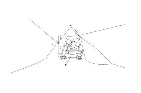
In Figures -1 and 2 an example of a vehicle 1 is represented,
the position of which is to be determined in a defined region 3
represented in Fig. 3, e.g. a storage depot. Here it can be seen
that the vehicle 1 has a plurality of imaging sensor devices,
preferably digital cameras 2. The attachment to the vehicle 1 is
preferably undertaken such that the field of view registered by
the digital camera 2 is directed rearwards of the vehicle 1.
This is advantageous, = since in the case of industrial goods-
handling vehicles the field of view in the direction forwards of
the vehicle 1 is often restricted when transporting goods items.
When using a plurality of digital cameras 2 they can be attached
- as can be seen in Fig. 1 - such that the field of view of the
cameras 2 is directed in both the rearward and forward direc-
tions, wherein, needless to say, the lateral environment of the
vehicle 1 is also registered with the cameras 2.
Depending upon the circumstances of the environmental infra-
structure (e.g. size of the storage areas, size of the reference
markings,= size of the labels for goods identification, etc.) the
cameras 2 can have, a different resolution and framing rate. The
deployment of a digital camera 2 of the Pointgrey Research GRAS-
20S4M-C BW Grasshopper type with a resolution of 1624 x 1224
pixels and a framing rate of up to 30 fps (frames per second) is
conceivable.
The digital cameras 2 are equipped for industrial deployment
and are linked to a computer (industrial PC) in the interior of
the vehicle, either without cables (with a replaceable battery
and wireless data transfer), or with cables. Processing of the
image data delivered by the digital cameras 2 is undertaken in
the computer.
In the schematic view in accordance with Fig. 3 can be seen
the defined region 3 designed as a storage space. Here in par-
ticular two different types of reference feature, of Type I (T1)
and Type 2 (T2), are shown.
CA 02786407 2012-07-05
- 12 -
Here the T1 reference features are stationary reference fea-
tures of a fixed design, with a unique identifying feature and
variable size.
These possess e.g. a rectangular shape (4 corner points) and
can consist of a black edge, a white surface, and black symbols
(letters, numbers, or other symbols). The combination of symbols
represents a unique identifying feature.
Examples are markings located on the floor, on walls or
posts (e.g. storage markings or storage depot corridor mark-
ings), or signage. The size of these objects can vary depending
upon the environmental conditions. Markings in storage areas can
be e.g. 40 x 30 cm in size, markings on storage depot gangways
are somewhat larger at e.g. 80 x 60 cm, and signage on walls or
posts can even be e.g. 200 x 150 cm in size.
Each of the T2 stationary reference features is of fixed de-
sign, with no unique identifying feature, and of variable size.
These T2 reference features can be any stationary high-contrast
objects in the defined environment (e.g. fire extinguishers,
shelving, posts, etc.). A further example would be a right an-
gle, which is formed by two lines of marking on the floor, which
are located at approx. 90 degrees to one another (see Fig. 3:
A18/2: corner point of a storage area). These T2 reference fea-
tures possess no unique identifying features of their own (e.g.
in the form of a combination of symbols).
T3 stationary reference features are those of no fixed de-
sign, with no unique identifying features, and of variable size.
These T3 reference features are all high-contrast features of
any size and shape (e.g. edges of goods items or labels, con-
tamination on the floor, vehicles, etc.), which are for the most
part only located at one stationary location for a certain pe-
riod of time. These possess no unique identifying features of
their own (e.g. in the form of a combination of symbols).
The digital map of the defined region 3, i.e. of the defined
environment (e.g. storage depot) possesses a defined (global)
coordinates system, includes the reference features Tl, T2, T3
and their properties (e.g. coordinates, identifying features,
etc.), and can be used for purposes of electronic data process-
ing. In addition the digital map of the storage depot can in-
clude further specific properties of the defined environment
(e.g. global coordinates and dimensions of storage areas, etc.).
CA 02786407 2012-07-05
- 13 -
In Fig. 4 is shown a schematic example of a goods item 4,
wherein in particular the corner points 5 of the goods item 4
are called upon as temporary reference features for purposes of
determining an absolute position. In addition the goods item 4
can have a label 6, which in turn can have a unique identifying
feature such as, for example, a barcode or a unique identifica-
tion number executed in plain script, e.g. EAN 128.
Fig. 5 shows schematically a flow diagram of a method ac-
cording to the invention, which comprises a total of 18 steps of
the method. Here reference is made to a total of four different
types of reference features, which are defined as follows:
A: is a Type 1 reference feature and initially, i.e. before
the start of the method, is already stored with its properties
(measured coordinates, unique identifying feature) in the digi-
tal map.
V: is a Type I or Type 2 reference feature, which is stored
by the method with its properties (measured coordinates, unique
identifying feature) in the digital map, and initially, i.e. be-
fore the start of the method, is not stored in the digital map.
R: is a Type 1, Type 2, or Type 3 reference feature, which
is not stored in the digital map.
Z: is a Type 1, Type 2, or Type 3 reference feature, which
is temporarely stored in the digital map.
The individual steps of the method la - 18a can be summa-
rised as follows.
la - Recording of at least one digital image at a point in
time t.
2a - Detection of all reference features of the different
types as well as detection of a detail of the digital image in
which a reference feature is located (a so-called region of in-
terest - ROI).
3a - Identification of all types of reference features and
ROIs.
4a - Determination of the global, i.e. absolute, camera po-
sition, and thus the position of the vehicle per reference fea-
ture.
5a - Calculation of the coordinates per type of reference
feature by means of image processing algorithms of known art.
6a - Storage of the global coordinates per type of reference
feature in the digital map. With this the registration and meas-
CA 02786407 2012-07-05
- 14 -
urement of the types of reference feature is completed and the
types of reference feature can be identified in a further step
3a of the method.
7a - Initialisation of the ROI, i.e. selection and temporary
storage of the ROI for each reference feature plus image posi-
tion.
8a - Calculation of the transformation and the image differ-
ence by means of image processing algorithms of known art.
9a - Determination of the global camera position per type of
reference feature by means of image processing algorithms of
known art.
Steps 7a to 9a of the method thus represent a determination
of absolute position by means of marker tracking.
10a - For each identical reference feature the position is
determined by means of camera position at the point in time t
and a previous point in time t-1.
lla - Temporary storage of the Type R reference features in
the digital map.
12a - Determination of the global camera position per type
of reference feature by means of image processing algorithms of
known art.
With steps 10a to 12a of the method a determination of posi-
tion is thus executed by means of three-dimensional features.
13a - Detection of all goods items, labels and the corner
points of the corresponding goods items.
14a - Identification of the goods items by means of barcodes
= and/or plain script on the labels of the goods items.
15a - Determination of the global coordinates, or at least
one corner point, of the goods items.
16a - Determination of the global camera position by means
of image processing algorithms.
Steps 15a and 16a of the method thus represent a further de-
termination of absolute position by means of the labels of the
goods items.
17a - Conflation of the results from the individual methods
for purposes of determining position and from further items of
information, i.e. prior knowledge, which in particular can be
the following:
- Global coordination of regions in the defined environment
that cannot be navigated/driven through by the vehicle (e.g.
CA 02786407 2012-07-05
- 15 -
posts, walls, doors, shelving, goods items, etc.).
- Maximum possible alteration in position within a period of
time on the basis of the performance data of the respectively
deployed vehicle (max. speed, min. turning circle, max. accel-
eration/retardation) in combination with the prior knowledge
concerning the movement history (previously covered path, speed,
acceleration and rotation).
- Regions of the defined environment that cannot be reached
by the vehicle, as determined from the geometry of the vehicle
(length/width/height)
18a - Determination of the final global camera position by
means of state estimations in a dynamic process based on a fil-
ter system (e.g. particle filter)
In Fig. 6 can be seen in detail a stage of the method for
purposes of recognising and measuring reference features in the
defined region 3. With the aid of this stage of the method the
digital warehouse map of the defined environment is created in a
simple manner that saves effort and cost. This digital map
serves as the fundamental database for the described method for
purposes of continuous registration of the position of vehicles
1. In the defined environment 3 individual Type A reference fea-
tures are located at suitable points, i.e. a crossing point, for
example, on the storage depot's internal corridor.
The steps of the method can be individually summarised as
follows:
lb - Recording of digital images by means of digital cameras
installed on a vehicle or vehicles. A vehicle has executed, or a
plurality of vehicles have executed, journeys in the defined en-
vironment of the form such that all relevant regions of the de-
fined environment are registered by means of digital images.
2b - Detection means the recognition (but not the unique
identification ) of all reference features of Types A, V and R
by means of image processing algorithms.
3b - A calculation of absolute position can in principle
only be executed for the case in which at least one reference
feature of Type A or V is located in this image, otherwise the
subsequent image in time must be analysed.
The determination of the absolute position of this reference
feature can only be executed for the case in which at least one
reference feature of Type R is located in this image, otherwise
CA 02786407 2012-07-05
- 16 -
the subsequent image in time must be analysed.
4b - The objective of the method, namely the recognition,
determination of position and storage in the digital map of
hitherto unknown reference features can only be achieved for the
case in which at least one reference feature of Type R is lo-
cated in this image. For purposes of determining position of a
Type R reference feature at least two digital images with dif-
ferent angles of view (with a sufficiently large parallax) are
necessary (request of buffer storage of the Type R reference
feature, i.e. the reference feature has been already recognised
in a previous image).
5b - Specification means the determination of the properties
(e.g. shape) for all Type R reference features by means of image
processing algorithms and their buffer storage.
6b - Identification means the unambiguous recognition of the
properties (identifying features) of reference features of Types
A, V and R by means of image processing algorithms.
7b - A calculation of absolute position can be only executed
for the case in which at least one reference feature of Type A
or V is located in this image and this has been unambiguously
identified, otherwise the subsequent image in time must be ana-
lysed.
8b - Calculation of the global camera position by means of
image processing algorithms while taking into account all refer-
ence features of Type A or V identified under Item 6.
9b - llb - A calculation of the absolute position of the
Type R reference feature and an application of the global camera
position calculated under Item 8 can only be executed by means
of image processing algorithms for the case in which at least
one reference feature of Type R is located in this image, and
has been unambiguously identified, and already buffer stored,
otherwise the subsequent image in time must be analysed.
12b - 13b - The Type R reference feature is only stored in
the digital map under the presumption that minimum conditions
(e.g. a sufficiently large parallax in the case of two different
images with different angles of view) for the absolute position
calculated under item 11 have been fulfilled.
14b-17b - Continuously exercised method for the optimisation
of the accuracy of the global position of Type V reference fea-
tures stored in the digital map by means of the application of
CA 02786407 2012-07-05
- 17 -
the algorithms described under items 11-12.
Fig. 7 shows in detail a stage of the method for purposes of
determining absolute position by means of the continuous track-
ing of Type 1 and 2 reference features. The ROI (region of in-
terest) hereby represents that detail of the digital image in
which the reference feature is located.
The ROI is firstly initialised with the identification of a
Type A or Type V reference feature and is only re-initialised at
a later point in time if necessary (e.g. too great a distance
between the current global position and that camera position at
which the ROI is initialised for the first time). During the
initialisation the storage of the detail takes place, and the
initial transformation of this detail, which is calculated with
reference to the respectively current image.
The ROI is projected by means of a transformation (e.g. ho-
mography,...) of the image from the previous point in time t-1
onto the image for the subsequent point in time. From the image
difference the transformation alteration (and with that the al-
teration in position) is recalculated by means of optimisation
methods.
The steps of the method can be individually described as
follows:
lc - Recording of digital images in a defined environment by
means of digital cameras installed on a vehicle or vehicles.
2c - Search for buffer stored ROIs, which function as the
basis for the transformation calculation.
3c - Detection means the recognition (but not the unique
identification) of all reference features of Type A and Type V
by means of image processing algorithms.
4c - A calculation of absolute position can in principle
only be executed for the case in which at least one reference
feature of Type A or Type V is located in this image, otherwise
the subsequent image in time must be analysed.
5c - Identification means the unambiguous recognition of the
properties (identifying features) of reference features of Type
A and Type V by means of image processing algorithms.
6c - For the case in which at least one reference feature of
Type A or Type V is located in this image, and this reference
feature has been unambiguously identified, a calculation of ab-
solute position can be executed, otherwise the subsequent image
CA 02786407 2012-07-05
- 18 -
in time must be analysed.
7c - Calculation of the global camera position by means of
image processing algorithms while taking into account all refer-
ence features of Type A or Type V identified under Item 5.
8c - Initialisation of the ROI, i.e. selection and buffer
storage of the ROI for each reference feature with its image po-
sition.
9c - Transformation calculation, i.e. the search for the re-
lationship between the buffer stored ROI and the reference fea-
ture in a subsequent digital image in time.
10c - Calculation of the alteration in position by means of
image processing algorithms on the basis of the results from
Item 9.
llc - Calculation of the global camera position by means of
image processing algorithms while taking into account all al-
terations of position determined under Item 10.
12c - Check on the number of images downstream of the ini-
tialisation of the ROI in which no relationships could be found
in accordance with Item 9.
13c - If a defined threshold value in accordance with the
check described in Item 12 is exceeded, the buffer stored ROI is
deleted.
Advantageously therefore, an identification of the reference
feature is only necessary once, and is made possible by means of
a determination of position that is significantly more robust
and can also be executed at greater distances. In addition such
a determination of position is insensitive to contamination in
the defined region 3.
= Fig. 8 represents in detail the determination of absolute
position by means of the continuous tracking of Type 3 reference
features.
ld - Recording of digital images by means of digital cameras
installed on a vehicle or vehicles. A vehicle has executed, or a
plurality of vehicles have executed, journeys in the defined en-
vironment of the form such that all relevant zones of the de-
fined environment are registered by means of digital images.
2d - Detection means the recognition (but not the unique
identification) of all reference features of Types A, V, R and Z
by means of image processing algorithms.
3d - A calculation of absolute position can in principle
CA 02786407 2012-07-05
= - 19 -
only be executed for the case in which at least one reference
feature of Type A, V or Z is located in this image, otherwise
the subsequent image in time must be analysed. The determination
of the absolute position of this reference feature can only be
executed for the case in which at least one reference feature of
Type R is located in this image, otherwise the subsequent image
in time must be analysed.
4d - The objective of the method, namely the determination
of the position of the camera by means of Type R reference fea-
tures, can only be achieved for the case in which there is a
buffer stored ROI for a detected Type R reference feature.
5d - Deletion of all buffer stored ROIs, for which the cor-
responding Type R reference feature has not been detected.
6d - Identification means the unambiguous recognition of the
properties (identifying features) of reference features of Types
A, V, Z and R by means of image processing algorithms.
7d - A calculation of absolute position can only be executed
for the case in which at least one reference feature of Type A,
V or Z is located in this image and this reference feature has
been unambiguously identified, otherwise the subsequent image in
time must be analysed.
8d - 9d - If a defined threshold value in accordance with
the identification described in Item 6 is exceeded, the buffer
stored Type Z reference feature is deleted.
For 9d see 8d.
10d - A determination of the position by means of the camera
positions at the points in time t and t-1 can only be executed
for the case in which at least one reference feature of Type R
is located in this image and this reference feature has been un-
ambiguously identified, otherwise the subsequent image in time
must be analysed.
lld - Calculation of the global camera position by means of
image processing algorithms while taking into account all refer-
ence features of Type A and/or V and/or Z identified under Item
6, but without an identification of a Type R reference feature.
12d - Calculation of the global camera position by means of
image processing algorithms while taking into account all refer-
ence features of Type A and/or V and/or Z identified under Item
6, but with an identification of a Type R reference feature.
13d - Search for buffer stored ROIs and image positions of
CA 02786407 2012-07-05
- 20 -
the Type R reference features, which function as the basis for
the determination of position by means of image processing algo-
rithms.
14d - Storage of the global camera position.
15d - Storage of the ROI and image position of Type R refer-
ence features.
16d - A determination of position using the Type R reference
features is only undertaken under the presumption that minimum
conditions (e.g. a sufficiently large parallax in the case of
two different images with different angles of view) have been
fulfilled.
17d - By means of image processing algorithms the global po-
sition is calculated by means of camera position (determined un-
der Item 12) at the points in time t and t-1 for each identical
Type R reference feature.
18d - The position of the Type R reference feature deter-
mined under Item 17d is temporarily stored in the digital map,
and the Type R reference feature is thus converted into a Type Z
reference feature.
19d - 20d - If the minimum conditions described under Item
16d are not fulfilled the storage of the current global camera
position and image position of the Type R reference features
takes place.
Thus with the aid of such a determination of position no
calculation of a pure relative movement (determination of rela-
tive position) is required, but instead at each point in time
reference can be made back to absolute coordinates, as a result
of which the method for purposes of determining position becomes
more robust, and at the same time a more accurate and more ro-
bust determination of position is achieved compared with methods
of known art.