Note: Descriptions are shown in the official language in which they were submitted.
81614762
WELL PAD PLACEMENT
RELATED APPLICATIONS
[0001] This application claims the benefit of US Provisional Application
Serial
No. 61/534,926 filed September 15, 2011, and US Application Serial No.
13/596,540,
both entitled "Well Pad Placement".
BACKGROUND
[0002] Various industries rely on underground or subsurface placement of
piping and other equipment. For example, in the oil and gas industry, a rig or
pad to
place equipment underground may be located on a ground surface proximate to a
reservoir. As to offshore rigs or pads, these may be floating structures or
structures
with supports that extend to a seabed (a ground surface) to place equipment
below a
sea surface (a water surface) and below a seabed. Placement of such equipment
can
depend on any of a variety of factors.
[0002a] Unfortunately, depending on how the equipment is placed, contact
between lateral portions of wells and a reservoir may be poor. There is no
"one size
fits all" solution to developing reservoirs because there are significant
differences
between basins, and a high degree of variability within each reservoir.
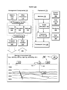
[0002b] It is an object to provide an improved method of producing a
resource
from a reservoir by improving placement of equipment such that contact with
the
reservoir is enhanced. It is to this end that the present disclosure is
directed.
SUMMARY
[0003] A method can include assigning constraints associated with an
environment and generating rig or pad placement options. Such constraints may
account for physical factors of an environment, physical factors of a rig or a
pad, cost
factors, legal factors or other factors. A method can optionally output
specifications
for a placement option, for example, to facilitate building a rig or pad. A
computer-
readable storage medium can include instructions to instruct a computing
system to
receive constraint information for a multilayer model of an environment,
receive
configuration information for a drilling pad, and generate a ranking of
drilling pad
locations based on the constraint information, the configuration information
and the
1
CA 2788934 2018-12-13
,
,
81614762
multilayer model of the environment. A computer-readable storage medium can
include instructions to instruct a computing system to generate one or more
graphical
user interfaces for selection of regional geometry constraints for an
environment, for
selection of pad and well specifications for the environment, for selection of
pad
placement options for placement of pads in the environment, and for selection
of
presenting a cost surface or presenting pad locations. Various other
apparatuses,
systems, methods, etc., are also disclosed.
[0003a] According to an embodiment, there is provided a method comprising:
assigning
one or more constraints to a ground surface of an environment; assigning one
or more
constraints to a reservoir surface of the environment wherein the reservoir
surface
represents a reservoir of the environment as determined at least in part by
interpretation of
seismic data acquired by sensors; via a computing device, generating ground
and
reservoir cost surfaces based at least in part on the assigned constraints of
the ground and
reservoir surfaces; defining a pad configuration and well configuration
parameters for at
least one well that extends from a pad defined at least in part by the pad
configuration
wherein the well configuration parameters comprise a well head point to a well
heel point
distance parameter and a well heel point to a well toe point distance
parameter that defines
a length of a lateral portion of a well; via the computing device, based at
least in part on the
cost surfaces, generating a model of pad locations that conform to the defined
pad
configuration and the defined well configuration parameters wherein lateral
portions of
wells associated with the pad locations and defined by the well configuration
parameters
maximize contact with the reservoir represented by the reservoir surface; via
the
computing device, for at least one of the pads at a corresponding one of the
pad locations
of the model, rendering to a display a graphic of a plurality of well
trajectories defined at
least in part by corresponding well head, well heel and well toe points;
building the pad at
the pad location of the ground surface of the environment; drilling wells from
the pad
according to the well trajectories; and producing a resource from the
reservoir via the wells.
[0004]
This summary is provided to introduce a selection of concepts that are further
described below in the detailed description. This summary is not intended to
identify key
or essential features of the claimed subject matter, nor is it intended to be
used as an
aid in limiting the scope of the claimed subject matter.
2
CA 2788934 2018-12-13
81614762
BRIEF DESCRIPTION OF THE DRAWINGS
[0005] Features and advantages of the described implementations can be more
readily understood by reference to the following description taken in
conjunction with
the accompanying drawings.
[0006] Fig. 1 illustrates an example system that includes various
components for
simulating and optionally interacting with a geological environment;
[0007] Fig. 2 illustrates an example of an environment that includes
various
equipment and various features, which may be represented at one or more
levels;
[0008] Fig. 3 illustrates an example of method for generating pad
locations;
[0009] Fig. 4 illustrates an example of a method for providing placement
options for one or more pads;
[0010] Fig. 5 illustrates examples of graphical user interfaces for
interacting with a
pad placement process;
[0011] Fig. 6 illustrates examples of modules and graphical user interfaces
for pad
placement and design;
[0012] Fig. 7 illustrates an example of a graphical user interface;
[0013] Fig. 8 illustrates an example of a graphical user interface;
[0014] Fig. 9 illustrates example modules and an example of a graphical
user
interface that includes a pad placement option implemented as a plug-in with
respect to a
framework;
[0015] Fig. 10 illustrates an example of a graphical user interface for
selecting
geometric restrictions as inputs for a pad placement process;
[0016] Fig. 11 illustrates an example of a graphical user interface for
geometric
modeling of one or more restrictions using a three-dimensional grid;
[0017] Fig. 12 illustrates an example of a graphical user interface for a
cost
functions associated with a geometric restriction;
2a
CA 2788934 2018-12-13
CA 02788934 2012-09-05
IS11.0544-CA-NP
[0018] Fig. 13 illustrates an example of a graphical user interface for
selecting
pad and well specifications as inputs for a pad placement process;
[0019] Fig. 14 illustrates an example of a graphical user interface for
selecting
placement options for a pad placement process;
[0020] Fig. 15 illustrates an example of a scenario to perform sensitivity
analysis, optimization or other processes;
[0021] Fig. 16 illustrates an example of a graphical user interface for
rendering
information associated with pad placement and restrictions; and
[0022] Fig. 17 illustrates example components of a system and a networked
system.
DETAILED DESCRIPTION
[0023] The following description includes the best mode presently
contemplated for practicing the described implementations. This description is
not to
be taken in a limiting sense, but rather is made merely for the purpose of
describing
the general principles of the implementations. The scope of the described
implementations should be ascertained with reference to the issued claims.
[0024] As mentioned, various industries rely on underground or subsurface
placement of piping and other equipment and placement of such equipment can
depend on any of a variety of factors. For example, an underground rock
formation
or existing underground equipment may be considered obstacles to avoid or that
introduce costs (e.g., drilling through the rock, removing or relocating
existing
equipment, etc.). Other factors can include property rights such as leasehold
boundaries, public infrastructure (e.g., roads, power lines, communication
lines, etc.),
and even moving obstacles such as ice formations (e.g., icebergs).
[0025] A pad may be a formation or structure to be located or placed for
purposes of performing one or more types of underground or subsurface
operations.
For example, in the oil and gas industry a ground surface pad may be a
temporary
drilling site constructed of materials such as gravel, shell or wood. Such
materials
may be local materials (e.g., sourced locally for reasons of cost,
environmental
impact, etc.). For some long-drilling-duration operations, deep wells, such as
the
ultradeep wells of western Oklahoma, or some regulatory jurisdictions such as
The
Netherlands, a pad may be constrained, for example, as having to be paved with
3
CA 02788934 2012-09-05
ISit 0544-CA-NP
asphalt or concrete. For temporary pads, after a drilling operation is over,
most of a
pad may optionally be removed, plowed back into the ground, etc.
[0026] A rig may be a machine used to drill a bore such as a wellbore. In
onshore operations, a rig may include various types of support equipment.
Major
components of a rig can include mud tanks, mud pumps, a derrick or mast,
drawworks, a rotary table or topdrive, a drillstring, power generation
equipment and
auxiliary equipment. Offshore, a rig can include various components, for
example,
as for an onshore rig. For offshore operations, a pad may be a vessel or
drilling
platform itself while the rig may be referred to as a drilling package.
[0027] To facilitate explanation of various examples of pad or rig
placement
processes and related processes, Fig. 1 shows an example of a system 100 that
includes various management components 110 to manage various aspects of a
geologic environment 150. For example, the management components 110 may
allow for direct or indirect management of sensing, drilling, injecting,
extracting, etc.,
with respect to the geologic environment 150. In turn, further information
about the
geologic environment 150 may become available as feedback 160 (e.g.,
optionally
as input to one or more of the management components 110).
[0028] In the example of Fig. 1, the geologic environment 150 may include a
vessel 151 as a pad equipped with a rig 153. The environment 150 may be
outfitted
with any of a variety of sensors, detectors, actuators, etc. For example,
equipment
152 may include communication circuitry to receive and to transmit information
with
respect to one or more networks 155. Such information may include information
associated with downhole equipment 154, which may be equipment to acquire
information, to assist with resource recovery, etc. Other equipment 156 may be
located remote from a well site and include sensing, detecting, emitting or
other
circuitry. Such equipment may include storage and communication circuitry to
store
and to communicate data, instructions, etc.
[0029] As to the management components 110 of Fig. 1, these may include a
seismic data component 112, an information component 114, a pre-simulation
processing component 116, a simulation component 120, an attribute component
130, a post-simulation processing component 140, an analysis/visualization
component 142 and a workflow component 144. In operation, seismic data and
other information provided per the components 112 and 114 may be input to the
4
CA 02788934 2012-09-05
IS11.0544-CA-NP
simulation component 120, optionally with pre-simulation processing via the
processing component 116 and optionally with post-simulation processing via
the
processing component 140.
[0030] As an example, the simulation component 120 may include entities
122. Entities 122 may be earth entities or geological objects such as wells,
surfaces,
reservoirs, etc. In the system 100, the entities 122 can include entities that
provide
for virtual representations of actual physical entities, for example, that are
reconstructed for purposes of simulation. The entities 122 may be based on
data
acquired via sensing, observation, etc. (e.g., the seismic data 112 and other
information 114).
[0031] As an example, the simulation component 120 may include a software
framework such as an object-based framework. In such a framework, entities may
be based on pre-defined classes to facilitate modeling and simulation. A
commercially available example of an object-based framework is the MICROSOFT
.NETTm framework (Redmond, Washington), which provides a set of extensible
object classes. In the .NETTm framework, an object class encapsulates a module
of
reusable code and associated data structures. Object classes can be used to
instantiate object instances for use in by a program, script, etc. For
example,
borehole classes may define objects for representing boreholes based on well
data.
[0032] In the example of Fig. 1, the simulation component 120 may process
information to conform to one or more attributes specified by the attribute
component
130, which may be a library of attributes. Such processing may occur prior to
input
to the simulation component 120. Alternatively, or in addition to, the
simulation
component 120 may perform operations on input information based on one or more
attributes specified by the attribute component 130. As an example, the
simulation
component 120 may construct one or more models of the geologic environment
150,
which may be used for simulation of behavior of the geologic environment 150
(e.g.,
responsive to one or more acts, whether natural or artificial). In the example
of Fig.
1, the analysis/visualization component 142 may allow for interaction with a
model or
model-based results. Additionally, or alternatively, output from the
simulation
component 120 may be input to one or more other workflows, as indicated by a
workflow component 144. A workflow may include worksteps, for example, where
each workstep acts upon input to provide an output (e.g., input may be data
and
CA 02788934 2012-09-05
IS11.0544-CA-NP
output may be a visualization of the data, an analysis of the data, etc.). In
the
example of Fig. 1, dotted lines indicate possible feedback within the
management
components 110. For example, feedback may occur between the
analysis/visualization component 142 and either one of the processing
components
116 and 140.
[0033] As an example, the management components 110 may include
features of a commercially available simulation framework such as the PETREL
seismic to simulation software framework (Schlumberger Limited, Houston,
Texas).
The PETREL framework provides components that allow for optimization of
exploration and development operations. The PETREL framework includes
seismic to simulation software components that can output information for use
in
increasing reservoir performance, for example, by improving asset team
productivity.
Through use of such a framework, various professionals (e.g., geophysicists,
geologists, and reservoir engineers) can develop collaborative workflows and
integrate operations to streamline processes. Such a framework may be
considered
an application and may be considered a data-driven application (e.g., where
data is
input for purposes of simulating a geologic environment).
[0034] As an example, the management components 110 may include
features for geology and geological modeling to generate high-resolution
geological
models of reservoir structure and stratigraphy (e.g., classification and
estimation,
facies modeling, well correlation, surface imaging, structural and fault
analysis, well
path design, data analysis, fracture modeling, workflow editing, uncertainty
and
optimization modeling, petrophysical modeling, etc.). Particular features may
allow
for performance of rapid 2D and 3D seismic interpretation, optionally for
integration
with geological and engineering tools (e.g., classification and estimation,
well path
design, seismic interpretation, seismic attribute analysis, seismic sampling,
seismic
volume rendering, geobody extraction, domain conversion, etc.). As to
reservoir
engineering, for a generated model, one or more features may allow for
simulation
workflow to perform streamline simulation, reduce uncertainty and assist in
future
well planning (e.g., uncertainty analysis and optimization workflow, well path
design,
advanced gridding and upscaling, history match analysis, etc.). The management
components 110 may include features for drilling workflows including well path
6
CA 02788934 2012-09-05
IS11.0544-CA-NP
design, drilling visualization, and real-time model updates (e.g., via real-
time data
links).
[0035] As an example, various aspects of the management
components 110
may be add-ons or plug-ins that operate according to specifications of a
framework
environment. For example, a commercially available framework environment
marketed as the OCEAN framework environment (Schlumberger Limited, Houston,
Texas) allows for seamless integration of add-ons (or plug-ins) into a PETREL
framework workflow. The OCEAN framework environment leverages .NET tools
(Microsoft Corporation, Redmond, Washington) and offers interfaces for
development. As an example, various components may be implemented as add-ons
(or plug-ins) that conform to and operate according to specifications of a
framework
environment (e.g., according to application programming interface (API)
specifications, etc.).
[0036] Fig. 1 also shows an example of a framework 170 that
includes a
= model simulation layer 180 along with a framework services layer 190, a
framework
core layer 195 and a modules layer 175. The framework 170 may be the
commercially available OCEAN framework where the model simulation layer 180
is
the commercially available PETREL model-centric software package that hosts
OCEAN framework applications.
[0037] In the example of Fig. 1, the model simulation layer 180
may provide
domain objects 182, act as a data source 184, provide for rendering 186 and
provide
for various user interfaces 188. Rendering 186 may provide a graphical
environment
in which applications can display their data while the user interfaces 188 may
provide a common look and feel for application user interface components.
[0038] In the example of Fig. 1, the domain objects 182 can
include entity
objects, property objects and optionally other objects. Entity objects may be
used to
geometrically represent wells, surfaces, reservoirs, etc., while property
objects may
be used to provide property values as well as data versions and display
parameters.
For example, an entity object may represent a well where a property object
provides
log information as well as version information and display information (e.g.,
to display
the well as part of a model).
[0039] In the example of Fig. 1, data may be stored in one or
more data
sources (or data stores, generally physical data storage devices), which may
be at
7
CA 02788934 2012-09-05
IS11.0544-CA-NP
the same or different physical sites and accessible via one or more networks.
The
model simulation layer 180 may be configured to model projects. As such, a
particular project may be stored where stored project information may include
inputs,
models, results and cases. Thus, upon completion of a modeling session, a user
may store a project. At a later time, the project can be accessed and restored
using
the model simulation layer 180, for example, which may recreate instances of
the
relevant domain objects.
[0040] Fig. 2 shows an example of an environment 200 that may be
modeled
using a multilayer model. For example, such a model may include a surface
level
201 (e.g., upper surface or layer) and a reservoir level 203 (e.g., lower
surface or
layer). As shown in Fig. 2, a structure 202 may be placed (e.g., built) on the
surface
level 201 for drilling or operating subsurface equipment 205 for exploring,
injecting,
extracting, etc. Further, placement of the structure 202 may aim to account
for
various constraints such as roads, soil conditions, etc. As shown, the
structure 202
= may be, for example, a pad for a rig or rigs (e.g., to drill, to place
equipment, to
operate equipment, etc.).
[0041] In the example of Fig. 2, the equipment 205 may be steam
assisted
gravity drainage (SAGD) equipment for injecting steam and extracting resources
from a reservoir 206. For example, a SAGD operation can include a steam-
injection
well 210 and a resource production well 230. In the example of Fig. 2, a
downhole
steam generator 215 generates steam in the injection well 210, for example,
based
on supplies of water and fuel from surface conduits, and optional artificial
lift
equipment 235 (e.g., ESP, etc.) may be implemented to facilitate resource
production. While a downhole steam generator is shown, steam may be
alternatively, or additionally, generated at the surface level. As illustrated
in a cross-
sectional view, the steam rises in the subterranean portion. As the steam
rises, it
transfers heat to a desirable resource such as heavy oil. As the resource is
heated,
its viscosity decreases, allowing it to flow more readily to the resource
production
well 230.
[0042] As to pad placement in such an environment for a SAGD
enhanced oil
recovery (EOR) operation, various factors may be relevant. For example, area
swept by a SAGD set, spacing between wells, etc. As an example, a model can
optionally account for such factors when determining one or more possible pad
8
CA 02788934 2012-09-05
IS11.0544-CA-NP
placement locations (or rig placement locations). As an example, where a pad
or
pads are mentioned, specifications, configurations, etc., for other locatable
equipment may be substituted for a pad or pads. As an example, specifications,
configurations, etc., may be provided for various types of locatable equipment
(e.g.,
structures or other equipment) and placement locations for such equipment
ascertained (e.g., consider ascertaining practical or optimal locations).
[0043] Fig. 3 shows an example of method 300 for generating pad locations.
The method 300 includes an assignment block 310 to assign one or more
constraints to an upper surface (e.g., a land surface 312 or a water or seabed
surface 314), an assignment block 320 to assign one or more constraints to a
lower
surface (e.g., associated with an oil or gas reservoir 322 or water, CO2 or
other
reservoir 324), a definition block 330 to define a pad configuration, a
definition block
340 to define pad placement options, a generation block 350 to generate pad
locations and an output block 360 to output specifications for at least one
pad
location (e.g., as blueprints 362, building costs 364, etc.).
[0044] The method 300 is shown in Fig. 3 in association with various
computer-readable media (CRM) blocks 311, 321, 331, 341, 351 and 361. Such
blocks generally include instructions suitable for execution by one or more
processors (or cores) to instruct a computing device or system to perform one
or
more actions. While various blocks are shown, a single medium may be
configured
with instructions to allow for, at least in part, performance of various
actions of the
method 300. As an example, a computer-readable medium (CRM) may be a
computer-readable storage medium. One or more CRM block may be provided for
graphical user interfaces (GUIs), etc.
[0045] As an example, a method can include assigning one or more
constraints to an upper surface, assigning one or more constraints to a lower
surface, defining a pad configuration, generating pad locations locatable on
the
upper surface that conform to the defined pad configuration and the assigned
constraints for the upper surface and the lower surface, and outputting
specifications
at least one of the generated pad locations. In such a method, assigning one
or
more constraints to an upper surface or a lower surface may include assigning
one
or more cost constraints or assigning one or more physical, environmental
constraints. As an example, a lower surface may be a two-dimensional
9
CA 02788934 2012-09-05
IS11.0544-CA-NP
representation of a reservoir and an upper surface may be a two-dimensional
representation of a ground or other surface (e.g., a surface suitable for one
or more
pad placement locations).
[0046] As to generating pad locations, a method may include generating
locations based at least in part on parameter values determined by applying a
probe
to locations on the upper surface. Such a probe may be a two-dimensional probe
(e.g., with a footprint based on one or more pad configuration definition
specifications) or a three-dimensional probe (e.g., of an appropriate depth
dimension
to consider one or more features defined or definable within a subsurface
volume).
As an example, a method may include a combination of two-dimensional and three-
dimensional probes.
[0047] As an example, a method may include defining a probe based at least
in part on a defined pad configuration and applying the probe to locations on
an
upper surface to determine parameter values, for example, where such values
can
indicate whether or to what degree a location is acceptable for placement of a
pad.
As an example, a method may include generating pad locations locatable on an
upper surface and ranking locations on the upper surface based at least in
part on
determined parameter values (e.g., as determined by applying a probe). As
mentioned, other types of equipment may substitute for a pad and, as such, a
probe
may represent specifications, a configuration, etc., for equipment other than
a pad.
[0048] As an example, constraints may be assigned to more than two
surfaces or, for example, be defined in a three-dimensional manner and/or
optionally
defined with a dimension such as time (e.g., one spatial dimension and a time
dimension, two spatial dimensions and time dimension, three spatial dimensions
and
a time dimension). As to a time dimension, consider a development, which may
be
planned or not but that may expand with respect to time, which may be a period
of
years. Where an operation or operations extend over a period of years, a
constraint
that varies with respect to time may be applied for one or more times. As to
three
spatial dimensions, where three dimensional constraint information is
available (e.g.,
accessible via a data source, measurements, interpolation, etc.), as an
example, a
three-dimensional probe may be implemented. As an example, a three-dimensional
probe may be implemented as a secondary process (e.g., fine tuning,
confirmation,
CA 02788934 2012-09-05
IS11.0544-CA-NP
etc.), for example, to focus in on a region of concern after application of a
two-
dimensional probe.
[0049] Fig. 4 shows an example of a method 400 for providing placement
options for one or more pads. The method 400 includes various blocks 412, 414,
416 and 418 for assigning constraints as well as to define one or more pad
configurations 441. As shown in the example of Fig. 4, the constraints are
provided
as input to a cost block 420 that forms one or more cost surfaces, for
example, for a
ground level and a reservoir level. Along another branch of the method 400,
the pad
configuration information is received as input to a probe block 460 that
constructs a
probe or probes to probe the one or more cost surfaces of the cost block 420.
Upon
application of the probe to the one or more costs surfaces, the method 400 can
output placement options as pad locations, as indicated by a pad location or
output
block 480.
[0050] The method 400 is shown in Fig. 4 in association with various
computer-readable media (CRM) blocks 413, 415, 417, 419, 421, 441, 461 and
481.
Such blocks generally include instructions suitable for execution by one or
more
processors (or cores) to instruct a computing device or system to perform one
or
more actions. While various blocks are shown, a single medium may be
configured
with instructions to allow for, at least in part, performance of various
actions of the
method 400. As an example, a computer-readable medium (CRM) may be a
computer-readable storage medium. One or more CRM block may be provided for
graphical user interfaces (GUIs), etc.
[0051] Fig. 5 shows examples of graphical user interfaces (GUIs) 500 and
550
for interacting with a pad placement process. In the GUI 500, a portion may
present
a representation of data 501 for an environment, for example, sliceable along
various
planes 503. Further, the GUI 500 may present a setup menu 510 that allows for
input of subsurface data 514 and surface data 518. In Fig. 5, the GUI 550 may
present various information related to output from a method such as the method
400
of Fig. 4. For example, a ranking graphic 560 may present a ranking of
placement
options, a quick view graphic 570 may present a simplified view of a placement
option and a multidimensional view 580 may present details of a placement
option,
optionally responsive to selection of one of the ranked placement options via
the
ranking graphic 560. As shown, the graphic 580 may include a cursor 585 that
11
CA 02788934 2012-09-05
IS11.0544-CA-NP
allows for zooming, rotating, panning, display of properties, highlighting of
properties,
pad specifications, estimated pad costs, estimated pad building time, or other
functions. In the example of Fig. 5, the quick view graphic 570 shows two sets
of
equipment, which may be, for example, equipment associated with a SAGD or
other
[OR operation.
[0052] The GUI 500 and the GUI 550 are shown in Fig. 5 in association with
various computer-readable media (CRM) blocks 505 and 555. Such blocks
generally include instructions suitable for execution by one or more
processors (or
cores) to instruct a computing device or system to perform one or more
actions.
While various blocks are shown, a single medium may be configured with
instructions to allow for, at least in part, performance of various actions
such as
rendering, controlling, inputting, outputting, etc. As an example, a computer-
readable medium (CRM) may be a computer-readable storage medium.
[0053] Various examples of graphical user interfaces (GUIs) are shown in
Figs. 6 to 16. In such examples, a pad placement module (e.g., as a plug-in to
a
framework) may be used in conjunction with a pad well design module (e.g., as
a
plug-in to a framework). A graphic from a pad placement process may include
markers that identify well head points, for example, resulting from an
analysis that
accounts for one or more constraints. Such a graphic may illustrate potential
wells to
be drilled from a well point or points and optionally one or more other
features (e.g.,
other wells, obstacles, constraints, etc.). As an example, surface and
reservoir
restrictions may be show using color coding for features such as pre-existing
wells,
surface acreage available, a reservoir target area, roads, rivers, etc.
[0054] As an example, a pad placement module may operate in conjunction
with a pad well design module in a manner that first identifies and
characterizes
possible surface pad locations, and second, creates one or more wells
underneath a
pad. A process may, for example, generate thousands of wells following
restrictions
at a ground level (e.g., an upper surface) and a reservoir level (e.g., a
lower surface).
[0055] As an example, a pad placement module may interoperate with a
framework such as the PETREL framework, for example, to generate pad surface
locations. As an example, a user may customize pad well configurations,
restrictions
pertinent to ground level and reservoir level, and create one or more cost
schemes.
A pad placement module may include functionality to perform one or more
sensitivity
12
CA 02788934 2012-09-05
IS11.0544-CA-NP
studies, for example, on well length, orientation, etc. As an example,
integration with
a pad well design module may allow for creation of wells at one or more
identified
surface pad locations. As an example, a process for determining a field
development plan can include performing one or more pad placement processes.
[0056] As to restrictions, as an example, one or more restrictions can be
described using lines, polygons, regular surfaces, etc., and applied at, for
example, a
reservoir level (e.g., lower surface) or a ground level (e.g., upper surface).
As an
example, one or more cost functions may indicate where an allowable drilling
area is
or, for example, may implement a cost structure. As an example, a pad
placement
process may demonstrate cost to drill in relationship to one or more features
(e.g., a
pad being located closer to a river, a road, etc.). As to a geometric
restriction, a pad
placement process can include assigning a cost function (e.g., a cost
structure).
[0057] As an example, a user may specify which pad configuration or
configurations to use along with well parameters and one or more strategies
for
computations for a pad placement process. As an example, pad well parameters
can be used to indicate total aerial space a pad configuration may occupy
where, for
example, the same parameters may be used with a pad well design module. As an
example, a pad index attribute can optionally be created to indicate occupied
pad
locations and to show which pads have less than maximum well lengths. Such an
attribute may be used with a pad well design module, for example, to help
truncate
one or more wells based on one or more pad placement restrictions.
[0058] Fig. 6 shows examples of some modules 610, 630 and 650, graphical
user interfaces 660, 662, 760 and 860 for pad placement and design and an
example of a spreadsheet 670, which may be editable by a user or otherwise
processed, analyzed, exported, etc. As shown, various implementations or
arrangements are possible for pad placement modules. The pad placement module
610 may be a stand-alone module while the module 630 may be an integrated or
plug-in module that optionally receives or transmits or otherwise exchanges
data
(directly or indirectly) with the module for pad well design 650. The GUIs 660
and
662 provide for selection of a pad placement or pad well design process. The
GUIs
760 and 860 pertain to various aspects of pad well design, for example, as
shown in
Fig. 7 and Fig. 8, respectively.
13
CA 02788934 2012-09-05
IS11.0544-CA-NP
[0059] As to the GUI 660, in the example of Fig. 6, it includes a framework
plug-in option that extends a list of options in a tree type of arrangement.
As
indicated, a Pad Placement option and a Pad Well Design option are selected,
along
with various other options. The GUI 662 shows information and controls
rendered
for Pad Placement and Pad Well Design. As to Pad Placement, a template control
may be activated to select a template (e.g., "Testi") and, for example, an
option to
generate a cost surface or an option to generate pad locations may be
selected. As
to Pad Well Design, a template control may be activated to select a template
(e.g.,
"Test Placement").
[0060] Fig. 7 shows an example of the GUI 760. In the example of Fig. 7,
control graphics provide for creation of a new pad well design or editing of
an
existing pad well design. The GUI 760 also includes tabs for rendering
information
and controls germane to pad configurations, well configurations and name and
folder
options. In the example of Fig. 7, the tab for pad configurations is selected.
Rendered controls can include a pad origin location control for points and
attributes,
a ground level control for surface and offset, a rig height control, a pad
orientation
control, a control for pad configuration (e.g., number of wells, sides
parameters,
etc.), a control for a reservoir target for a surface, offset, heel and toe
elevation,
tolerance (e.g., distance, number of design points, etc.) and a control for
one or more
target limit properties (e.g., to select a property, assign a condition,
etc.). Control
buttons may be provided to "make" a pad well design, to "apply" selections
and/or
field entries, to "OK" selections and/or entries, to "cancel" selections
and/or entries,
etc.
[0061] Fig. 8 shows an example of the GUI 860. In the example of Fig. 8,
control graphics provide for creation of a new pad well design or editing of
an
existing pad well design. The GUI 860 also includes tabs for rendering
information
and controls germane to pad configurations, well configurations and name and
folder
options. In the example of Fig. 8, the tab for well configurations is
selected.
Rendered controls can include a well length from heel to toe control, a
vertical
spacing between wells control, a horizontal spacing between wells control, a
height
of toe above heel control, a step out from a well head to a heel control an
initial
inclination of a well control, a minimum well length from heel control,
kickoff controls
for elevation and minimum kickoff measured depth, collision detection controls
for
14
CA 02788934 2012-09-05
IS11.0544-CA-NP
well or distance to well properties, a safety distance, etc., and a dogleg
severity
control. Control buttons may be provided to "make" a configuration file, etc.,
to
"apply" selections and/or field entries, to "OK" selections and/or entries, to
"cancel"
selections and/or entries, etc.
[0062] Fig. 9 shows example modules 900 and an example of a
graphical user
interface 970 that includes a pad placement option 975 implemented as a plug-
in
with respect to a framework. As an example, the modules 900 may be configured
as
one or more computer-readable media (e.g., storage media) with processor-
executable instructions to instruct a computing system to: receive constraint
information for a multilayer model of an environment (see, e.g., module 910);
receive
configuration information for a drilling pad (see, e.g., module 920); generate
a
ranking of drilling pad locations based on the constraint information, the
configuration
information and the multilayer model of the environment (see, e.g., module
930);
present, via a graphical user interface, at least some of the ranked drilling
pad
= locations (see, e.g., module 940); and output specifications for at least
one of the
drilling pad locations based on input received via the graphical user
interface (see,
e.g., module 950). One or more other modules 960 may be included in the
modules
700.
[0063] As an example, a module may include instructions to
instruct a
computing system to output specifications to output a blueprint of a building
site for
building a drilling pad at one of the drilling pad locations, to output a
building costs
for building a drilling pad at one of the drilling pad locations, to output
operational
specifications for operation of equipment that may be placed via the drilling
pad
location, etc. A module may be provided that includes instructions to receive
configuration information for a drilling pad where the information is for an
offshore
drilling pad.
[0064] As an example, a module or modules may be in the form of
one or
more computer-readable media that include processor-executable instructions
that,
for example, instruct a computing device, a computer, a computing system, etc.
For
example, one or more modules may instruct a device or system to generate a
graphical user interface for selection of regional geometry constraints for an
environment, generate a graphical user interface for selection of pad and well
specifications for the environment, generate a graphical user interface for
selection
CA 02788934 2012-09-05
IS11.0544-CA-NP
of pad placement options for placement of pads in the environment; and
generate a
graphical user interface for selection of presenting a cost surface or
presenting pad
locations.
[0065] As an example, one or more modules may instruct a device
or system
to generate a graphical user interface for selection of presenting a cost
surface and
presenting pad locations, to generate a graphical user interface for selection
of a
plug-in to perform a pad placement process, to generate a graphical user
interface
for designing a well pad, etc. As an example, one or more modules may be
implemented as or form a plug-in to a framework.
[0066] Fig. 10 shows an example of a graphical user interface
1000 for
selecting geometric restrictions as inputs for a pad placement process (see,
e.g.,
fields 1010, 1020 and 1030). In the example of Fig. 10, the ground surface or
ground level field 1010 allows for specifying geometric restrictions, for
example, as
shown in field 1020 (e.g., away from buildings, dip less than 6, within lease
= boundary, within reservoir boundary, access to roads, and reservoir
targets). The
field 1030 provides graphical controls that allow for selection of applicable
location,
for example, a ground level or a reservoir (e.g., where the ground level may
be an
upper surface and the reservoir a lower surface). As mentioned, a probe may be
defined and applied to various locations at an upper surface where
restrictions of a
lower surface are taken into account in assessing the various locations.
[0067] Fig. 11 shows an example of a graphical user interface
1100 for a
property with respect to a three-dimensional grid (e.g., for defining a
restriction). In
such an example, a pad placement module can provide for creating a reservoir
thickness surface attribute attained from a 3D grid property. A user may
commence
creation of the attribute by selecting a geometrical modeling process that
renders the
GUI 1100 to a display. In the example of Fig. 11, a field may appear for "cell
height"
and "method type" to generate a property called "cell height" (e.g., a model
pane
under a property folder). In response, a 3D window may open where the property
may be toggled, for example, by selecting control next to the property's name.
In
such an example, color scaling may be implemented and optionally adjusted and
a
property filter function applied once a 3D grid has been selected. In a
property filter
control, a user may select a check box or other control to use a value filter
in
conjunction with a cell height property. In such an example, a user may adjust
a
16
CA 02788934 2012-09-05
IS11.0544-CA-NP
=
scale for visualization of certain values, for example, greater than a
selected value.
In turn, a rendering algorithm may adjust property color such that a color
change
occurs to indicate that a filter is being applied. As an example, an option to
make a
map from a property may be presented and calculations may be applied on the
filtered cells, for example, to create an average surface map (e.g., "average
map for
cell height"). Setting of the surface map may be available as well as a
conversion
process to convert information to a set of polygons along edge of a selected
surface.
As an example, a polygon set may be named "reservoir_boundary" and optionally
moved into a "restrictions" folder (e.g., via a drag-and-drop operation).
Thereafter, a
user may access the created "reservoir_boundary" as a restriction in a pad
placement process.
[0068] Fig. 12 shows an example of a graphical user interface
1200 for
generating a cost function. As an example, a cost surface may aim to convey
"drillable area" as where available pad locations are at an upper surface and
a lower
= surface. In such an example, cost may be set to 0, for example, where a
range of x-
values denotes the closest a well can be drilled to an object or boundary. As
an
example, a scenario may indicate a ground level surface where there are no
surface
restrictions, and no costs tied to any attribute or border distance. In such
an
example, a drillable area may be an entire ground level surface, and the cost
to drill
may be 0 at any given location. Alternatively, as an example, a cost surface
may
contain more complexity. For example, other than indicating "drillable area,'
it may
also show cost conventions with respect to surface and reservoir-defined
parameters, like rivers, cities, reservoir thickness, dip angle, etc. Such an
approach
can provide a user with an ability to incorporate many real-life decision-
pending
drilling parameters into a pad placement process.
[0069] As an example, a process can include one or more cost
functions
specified for each geometric restriction added to the process. A cost function
may
be specified in arbitrary units, for example, where "x" describes a relative
distance or
property value range to be considered in the cost function versus the relative
"cost".
Such an approach can allow a user to create as many cost functions using a
variety
of inputs (either through a surface attribute, or polygons, or lines). For
polygons, "x"
may correspond to distance. For example, a cost scheme could be created where
the closer a pad is to a corresponding object (e.g., an object such as in the
17
CA 02788934 2012-09-05
S11. 0544-CA-NP
PETREL framework), the higher the cost of the pad/well. For example, a
surface
geometric restriction like "Rivers" may be represented by polygon lines. Logic
may
be conveyed as something like "we cannot drill within 500 feet of the river,
it will be
more expensive to drill within 500-1000 feet, and the cost will become less,
the
further we drill from the river". For such logic, "x" can refer to a 2D
distance to the
polygon lines that represent the "Rivers" restriction. To indicate that it is
not practical
to drill within 500 feet of the associated polygon lines "Rivers," the first
"x" value may
be 500. A default cost function may apply a 0 cost from an x-value of 0 to
10,000. If
applied to polygon geometric restrictions, this means that a pad location can
exist
within 0 and 10,000 units from the dropped polygon. In such an example, a 0 x-
value
can be seen as a floor restriction and an x-value of 10,000 as a cap. In the
example
of Fig. 12, cost is shown as decreasing in a stepwise manner with respect to
x.
[0070] As an example, a cost function can act to limit a drillable area,
for
example, where x-min and x-max values limit a proximity/range of "drillable"
locations. In such an example, by limiting the minimum or maximum values of
"x," a
user has the ability to limit or enable available drillable areas at the
surface and
reservoir levels. As an example, a cost function can establish a cost scheme
relative
to a surface property (e.g., a cost function may be based on a surface
attribute). In
such an example, a surface attribute such as z-depth can be used to show an
increased well cost based on depth. As an example, a surface may have a
property
like NTG defined that can be used in a cost function to indicate non-drillable
locations at a surface level to be available where NTG is less than a cost
value. As
an example, a cost function can establish a cost scheme relative to proximity
of
polygon lines. For example, a process may include one or more of roads,
pipelines,
property lines, etc. and: (a) where both sides of a polygon are selected, a
cost
function may be applied to each side of the polygon line; (b) where an inside
is
selected, items outside of the closed polygon may not be considered and the
cost
function may be applied to the inside of the polygon (e.g., for use to
describe a lease
area, reservoir boundary or some other confining restriction); or (c) where an
outside
is selected, items inside of the closed polygon may not be considered and the
cost
function may be applied to the outside of the polygon (e.g., examples may
include
cities, airfields, residential areas, where drilling may not be allowed within
a given
18
CA 02788934 2012-09-05
IS11.0544-CA-NP
=
representative polygon, and may be more expensive the closer a pad is to the
given
polygon boundary, etc.).
[0071] Fig. 13 shows an example of a graphical user interface
1300 for
selecting pad and well specifications as inputs for a pad placement process
(see,
e.g., field 1310). For a selected input specification, a graphic 1330 may
provide a
representation as a pad well head preview. While pad selection is shown in the
example of Fig. 13 (and various other examples), other type of equipment
(e.g.,
structure, etc.) may be specified, configured, etc., and placement options
provided
(e.g., via execution of a probe-based method).
[0072] As an example, a pad placement process can consider a list
of
configurations sequentially: first, trying to use the first pad configuration,
followed by
the second configuration in the list, and so on. In such an example, if no pad
configurations from the list are suitable, then a location may be left empty.
As an
example, a user may set up a process to start a list with the most desirable
pad
= configuration to be considered first, the next most desirable pad
configuration
second, and so on, so that the least number of pads may be used to supply the
most
number of wells.
[0073] In the example of Fig. 13, the pad well head preview
graphic 1330 may
be generated by a pad placement module as a schematic to illustrate how
different
wells in a pad may be organized based on geometry specified, which may be, for
example, in a form of an XML file (e.g., mark-up language). Such a graphic may
show locations of individual wells with reference to a pad location (e.g.,
optionally via
consumption of mark-up language or other instructions).
[0074] In the example of Fig. 13, for a pad selection tab of a
pad placement
process, a user may drop down or load the following well pad configurations
8WX4
and 3WX3; noting that other configurations can be added/edited (e.g., via an
XML or
other file). A user may, for a selected configuration, actuate a drop down for
a stress
attribute (e.g., stress direction) and review various associated parameters.
As an
example, a pad orientation field may provide for a pad's azimuth that
indicates a
degree orientation that a pad has and a sum of a surface attribute (e.g.,
dropped in
the stress attribute field, plus the value in the offset field (e.g., by
default it may be 0)
can indicate an orientation for the pad. As an example, a placement options
tab may
19
CA 02788934 2012-09-05
IS11.0544-CA-NP
allow for an option to automatically rotate a pad and to check various
orientations
(e.g., at specific increments) to determine a best orientation of a pad.
[0075] As to well length from heel to toe, this may be a length
of a well from a
heel point to a toe point of the well. Such a parameter may be used to
determine a
length of a horizontal lateral of a designed well. As to drainage area, this
may be
defined as a bounding box of points representing the heels and toes (e.g., on
both
sides). As an example, a drainage area calculation may be based on a 0 degree
orientation, for example, to calculate a theoretical drainage area that may be
affected
by a well in a pad. As to a minimum well length from heel to toe, this may
allow a
user to set a minimum desired length, which if not met, may avoid well
creation. If a
default value of 0 is used, then the minimum well length may be a value
entered in a
well length from heel to toe field.
[0076] As to horizontal spacing between wells, such a parameter
can specify
spacing between heel (or toe) locations of two or more wells in a pad. As to
step out
= from a well head to a heel, it may be a lateral distance allowed between
a well head
point and the heel point of a well trajectory. As an example, a border
distance
parameter may control minimum distance between wells in a neighboring pad
(e.g., x
and y distances that a nearest well from an adjacent pad may exist at with
relation to
the wells of a given pad).
[0077] Fig. 14 shows an example of a graphical user interface
1400 for
selecting placement options for a pad placement process (see, e.g., fields
1410,
1420, 1430, 1440 and 1450). Further control graphics or graphical controls
1460,
1470, and 1480 allow a user to select and a machine to receive instructions or
commands to perform actions associated with a cost surface or surfaces, pad
locations, or a cost surface or surfaces and pad locations.
[0078] As to "rank by pad count" (see, e.g., the field 1420),
such a strategy
may aim to further maximize a total pad count. For example, through such a
selection, a number of top-listed pads that can be placed in an I-direction
may be
counted_ Such a strategy may consider other combinations varying different
applicable pad configurations in a pad selection list and, for example, select
a best
combination of pads (e.g., the option having the highest number of pad wells
in the I-
direction) as the final choice. Such a strategy first determine if a surface's
I-direction
CA 02788934 2012-09-05
IS11.0544-CA-NP
coincides with a pad well orientation, for example, to see if a mismatch
exists, which
may impact a rank by pad count process.
[0079] As to "optimize ground cost" (see, e.g., 1430), as an example, a pad
placement process may perform a cost minimization that will not remove pads,
since
a goal of the pad placement process may be to maximize reservoir contact, but
rather will shift existing pad locations to reduce the total cost, if
possible. For
example, within the same increment a pad may be shifted from a ground location
with a surface cost of 10 to a location with a surface cost of 8. In such an
example, a
new pad location after cost optimization may, for the same reservoir coverage,
demonstrate a lesser cost.
[0080] As an example, a cost optimization process may be iterative as
moving
a pad from one location to another may enable additional movements for one or
more pads nearby. As an example, a module can determine whether an iteration
results in a lower cost, for example, such that if the module's process is
stopped
before it is complete, the module can output pad locations that bear no higher
cost
than the pad locations without the optimization. Such a process may be useful
in
demonstrating cost sensitivity between two potential pad locations. However, a
first
priority may be to maximize contact with a reservoir surface (e.g., a lower
surface);
thus, cost optimization may be applied as an adjustment to strategy-generated
points.
[0081] As to "generate pad locations for selected strategies" (see, e.g.,
the
field 1440), such an option can show pad locations for each selected strategy.
As an
example, if this option is not toggled on, a case with highest reservoir
coverage may
be output as a final pad locations point set.
[0082] As to "minimum pad size" (see, e.g., 1450), this may be used for
selection of dimensions of a minimum pad size. For example, for a rectangular
pad,
a width and height may be provided; whereas, for a circular pad, a radius may
be
provided. Such an option may operate in conjunction with a pad geometry, for
example, to display appropriate options that can define a minimum pad size.
[0083] As to the control 1460, this can initiate generation of cost
surfaces for a
ground level (e.g., upper level) and for a reservoir level (e.g., lower
level). As an
example, resulting surfaces can be found in a folder, for example, in an input
pane.
As an example, surfaces may be toggled on one at a time (e.g., in a 2D or 3D
21
CA 02788934 2012-09-05
IS11.0544-CA-NP
=
window) to verify that geometric restrictions were used in an intended way,
for
example, that the ground cost surface shows no cost surface area within it.
[0084] As to the control 1470, this can initiate generation of
pad surface
locations, for example, represented by a point-set. As an example, such a set
may
be visualized in a in a 2D or 3D window with surface restrictions to see how
the pad
locations were chosen with respect to these restrictions. In such an example,
distance between a pad location and a restriction polygon may be viewed while
referring to a respective cost function input. As an example, a pad placement
point-
set may be dropped into a pad well design input field. In such an example,
well
trajectories deviating from the pad well head may be created. As to the
control 1480,
this may be used to initiate both generation of cost surfaces and generation
of pad
surface locations.
[0085] Fig. 15 shows an example of a scenario 1500 that includes
an
environment layer 1502, a parameter layer 1504 and a system layer 1506. In the
= example of Fig. 15, the environment layer 1502 accounts for an
environment 1501
and goals 1503 associated with that environment. For example, the environment
1501 may be a field (e.g., including subsurface) that includes one or more
reservoirs
and the goals 1503 may be financial or other goals related to exploration,
extraction,
storage, etc., with respect to the field. The parameter layer 1504 includes
constraints 1532 and other parameters 1534, which may be derived from the
environment layer 1502. For example, if one of the goals 1503 is to drill a
well in the
environment 1501, then the parameter layer 1504 may include parameters (e.g.,
constraints or other) that characterize a pad configured to perform drilling.
[0086] In the example scenario 1500 of Fig. 15, the system layer
1506
includes a framework 1510 and a model simulation module 1520 where the
framework 1510 can interact with one or more plug-ins such as a pad placement
plug-in 1540, a pad well design plug-in 1550, and one or more other plug-ins
1570.
For example, the framework 1510 may be or provide at least some features of
the
OCEAN framework and the model simulation module 1520 may be or provide at
least some features of the PETREL simulation software framework.
[0087] As an example, the system layer 1506 may receive parameter
values
from the parameter layer 1504 and perform simulations where the simulations
rely
on input of at least some of the parameter values to one or more of the plug-
ins
22
CA 02788934 2012-09-05
IS11.0544-CA-NP
1540, 1550 and 1570. Output from a simulation may be directed to the parameter
layer 1504, for example, for purposes of a sensitivity analysis, optimization,
etc., and
optionally to the environment layer 1502, for example, for purposes of
gathering
more information about the environment 1501, selecting another environment,
adjusting or revising one or more goals 1503, or a combination thereof.
[0088] As to a sensitivity analysis, an example of a graphical user
interface
1590 provides for testing variable well length via template input fields 1593
and 1594
according to options provided in selection boxes for cost surface generation
1595
and pad location generation 1596. Such an analysis can be integrated into the
scenario 1500 with respect to the system layer 1506 and the other layers 1502
and
1504. The output of a sensitivity analysis may link environment 1501 and goals
1503 with respect to particular pad placement options, for example, based on
constraints for acceptable pad configurations. As to the example of the GUI
1590, it
demonstrates a script (see, e.g., 1, 2, 3, 4, and 5) that can set a well
length to a list
of values (1500, 2000, 2500) and generate pad locations, given each of these
well
lengths, to determine how sensitive pad locations are to such variations in
well
length.
[0089] As to optimization, as shown, the framework 1500 can interact with
the
plug-ins 1540, 1550 and 1570 and the simulation module 1520 to optimize one or
more parameter values of the parameter layer 1532. For example, if a
particular one
of the goals 1503 is economic, then a cost function may be provided that
depends on
one or more of the parameters of the parameter layer 1506 where the framework
1510 optionally interacts with the plug-in 1570 that includes the cost
function such
that simulations, or more generally calculations, are performed in an
iterative or other
manner to maximize or minimize the cost function (e.g., depending on how the
function may be cast). Once the cost function is optimized, for example, via
interaction between the framework 1510 and the plug-in 1570 and optionally
other
layers 1504 and 1502, optimized parameter values as well as cost may be
communicated or presented in a manner for consideration with respect to the
environment 1501 and the goals 1503.
[0090] Fig. 16 shows an example of a graphical user interface 1600. In the
example of Fig. 16, various lines are shown with respect to well points, which
include
wells extending therefrom. A pad placement process may, for example, provide
data
23
CA 02788934 2012-09-05
IS11.0544-CA-NP
=
for rendering in such a manner to visualize output from the process and
various
constraints with respect to the output. In the example of Fig. 16, a well
point 1610 is
shown as including various well paths extending in a direction away from a
boundary
1620, for example, which may represent a reservoir boundary, a lease boundary,
etc. As an example, various well points, boundaries, etc., may be selected
(e.g., via
an input device such as a mouse, a touch screen, etc.) where options may be
presented in a menu or other form, for example, to view additional
information, to
edit information, etc. As an example, a tool may be available to position,
rotate, etc.,
one or more well points, paths, boundaries, etc., optionally for consideration
as input
to a revised plan.
[0091] As an example, a method can include adjusting (e.g., systematically)
one or more parameters values (e.g., constraints, pad configuration, etc.) to
determine how sensitive one or more results (e.g., simulation output) is with
respect
to the one or more parameters. For example, such a sensitivity analysis may
look
for economic sensitivity, production sensitivity, etc., to a single parameter
or to
multiple parameters. As an example, a method can include adjusting one or more
parameter values (e.g., for constraints, pad configurations, etc.) by an
optimizer to
maximize a value such as production from wells proposed to be drilled from one
or
more pads.
[0092] As an example, a pad placement module can provide for user input,
for
example, to allow a user to experiment with different pad configuration
parameters,
such as well length or others and to determine the best parameter to be used
for the
field development.
[0093] As an example, a method can include adjusting at least one of a
constraint value, a pad configuration definition value, or a constraint value
and a pad
configuration definition value; and generating pad locations to determine
sensitivity
of specifications for the generated pad locations to the adjusting of the at
least one
value. As an example, a method can include providing a function that depends
on at
least one of a constraint value, a pad configuration definition value, or a
constraint
value and a pad configuration definition value; and optimizing output of the
function
by generating pad locations responsive to adjusting at least one of the at
least one
value of the function.
24
CA 02788934 2012-09-05
IS11.0544-CA-NP
[0094] As an example, a workflow process may optionally be a process
associated with the geologic environment 150 of Fig. 1 (e.g., surveying,
building,
sensing, drilling, injecting, extracting, modeling, simulating, etc.). For
example,
output from a pad placement process may aid in surveying, building, operating,
etc.,
a pad or related equipment. As an example, consider a workflow that includes
communication of information as to pad placement options via a network to
equipment located at a site (e.g., computer, cell phone, specialized
equipment, etc.).
Such information may assist with a survey that acquires additional information
and
that communicates that additional information to equipment for further
optimizing pad
placement options. For example, information requesting more detailed survey
(e.g.,
locations of restrictions, soil conditions, etc.) may be communicated and, in
response, return data from the more detailed survey to hone placement options.
[0095] As an example, a pad placement process or a system for pad
placement may, for example, further operate or be configured to control
machinery,
equipment, or communicate location data to separate devices to influence the
operation of those devices in a drilling or pad placement operation. As an
example,
once a suitable pad placement location is determined, separate devices, such
as
machinery for drilling, earth moving, etc., may be controlled to construct a
pad, place
wells via the pad, travel to a pad location, or be otherwise affected in a
drilling, pad
placement or other associated operation.
[0096] As an example, a pad placement product may optionally be suitable to
expand capability of the aforementioned PETREL @ framework, for example, by
offering a solution for regional well planning for shale gas producers and oil
sand
producers. Such a product may be applied to environments of interest in North
America and other environments as drilling for shale gas expands (e.g., to
other
continents).
[0097] When developing a regional field of shale gas or oil sand
reservoirs,
operators may consider drilling multiple wells from the same well pad location
in an
effort to maximize a return on investment. As an example, wells drilled at
each pad
may follow one of several standard configurations. For example, a well head
configuration can include a row of 4 producer wells located next to a row of 4
injector
wells for SAGD development in an oil sand reservoir. Operators may choose well
pad locations based on a combination of constraints at the ground level, such
as
CA 02788934 2012-09-05
IS11.0544-CA-NP
roads, rivers, buildings, etc., and constraints at the reservoir level, such
as lease
boundary. A concern of the operators can be selection of pad locations and
configurations to achieve more reservoir coverage. Among alternatives that
produce
the same reservoir coverage, a secondary concern can be selection of pad
locations
that incur lower cost. As an example, various approaches can optionally
address
both concerns.
[0098] As mentioned, a pad placement process may operate in conjunction
with a pad well design process, which may be a plug-in for creation of
proposed
wells on regular configurations (e.g., to be repeated at each pad location),
to
produce detailed well designs. Applications for such a process are reservoirs
with
high well density, such as shale gas or heavy oil. Such a process may seek to
control or define well length, vertical and horizontal spacing, orientation,
etc.
[0099] As an example, a method can include selecting well pad locations and
configurations, which conform to constraints both at the ground level, such as
roads
and surface gradients, and at the reservoir level, such as lease boundaries. A
system may be provided to implement such a method where the system allows
operators to define their own pad configurations to be used for the field
development.
In turn, such a system may generate probes from selected pad configurations,
and
apply the probes to combined constraints to produce well pad locations and pad
configurations parameters at each location.
[00100] As an example, one or more modules may optionally allow for
integration into framework, which, in turn, allows for overall optimization by
varying
certain parameters, such as well length or pad orientation, in pad
configurations.
Such an approach can allow a user to experiment with different parameters and
determine the best parameters for a development. Such a process may be aided
by
optimization processes (e.g., automated or semi-automated optimization to
reduce
manual demands). As an example, a method may include ranking well pad
locations, which may help producing pad locations with higher reservoir
coverage.
[00101] As an example, a method for placing well pads may be implemented,
for example, during a regional development planning of a shale gas or oil sand
field.
In such a method, in addition to the geological and petrophysical
characteristics of a
reservoir, other factors may be considered during the planning process, such
as
access to existing roads, avoidance of buildings, etc. Further, as operators
often
26
CA 02788934 2012-09-05
= IS11.0544-CA-NP
have more than one pad configurations, such a method can include input of
various
configuration characteristics to define possible pads.
[00102] As an example, a pad placement process can provide a way for a user
to capture a ground surface and other ground level constraints, for example,
using a
combination of surfaces, polygons and cost functions. Examples of ground level
constraints include, but are not limited to, access to existing roads,
avoidance of
towns, rivers and cliffs, etc. Such physical constrains may be represented by
either
polygons or surfaces when such a process is implemented (e.g., optionally in
conjunction with the PETREL framework).
[00103] As an example, a pad placement process can utilize one or more cost
functions to translate physical constraints such as distances, dips, etc.,
into
normalized costs representing an operators' preference for different physical
constraints. A process can optionally allow a user to define one or more cost
functions, for example, at different levels of details. For example, along a
spectrum,
at one end a normalized cost may be either as zero (e.g., null) or not
defined,
indicating either drillable or non-drillable conditions; whereas, at another
end, the
normalized cost can be representative to the real cost for drilling under
different
physical conditions, which enables a method to perform cost optimization in a
more
realistic way. Such a method may provide a way for a user to capture
constraints at
the reservoir level using surfaces, polygons and cost functions.
[00104] As an example, a system for performing a pad placement process may
optionally include a sub-system that combines constraints into, for example,
two cost
surfaces (e.g., at the ground level and the reservoir level) for representing
combined
costs. In such an example, for each grid node location of an upper surface,
the sub-
system calculates a normalized cost at the location for each specified
constraint, and
assigns the sum of the normalized cost of the individual constraint as the
combined
cost at the location.
[00105] As an example, a system may optionally provide a way for operators
to
define a set of standard well pad configurations that can be selected by a
user. For
example, each pad configuration may be made up with one or more well
configurations, and a well configuration may be described by coordinates of at
least
three control points (e.g., well head, heel and toe; see, e.g., Fig. 2). In
such an
example, coordinates of the control points can be specified using either
Cartesian
27
CA 02788934 2012-09-05
IS11.0544-CA-NP
coordinates or cylindrical coordinate system. Arithmetical expressions of
numbers
and pre-defined variables can then be used to specify the actual coordinates.
Such
an approach gives a user the option to vary certain parameters, such as well
length
and pad orientation, for the same pad configuration. Further, given such added
flexibility, integration into a framework (e.g., consider the PETREL
framework) can,
in turn, allow a user to experiment with different configuration parameters
quickly in
the search for better field development options.
[00106] As an example, a method can include converting a pad configuration
into a probe, for example, a 2-dimensional array representing relative
positions
between a location at a ground level (upper level or surface) and covered
reservoir
area at a reservoir level (lower level or surface). Given such a probe (or
probes),
shifting the probe across a two-dimensional ground surface grid can provide
for
determination of valid ground locations where the corresponding pad
configuration of
the probe may be placed, at least according to the method constraints. Such a
method may optionally include generating a pad allocation plan (e.g., a
blueprint),
which serves as the basis for additional pad placement options (e.g.,
optionally in
conjunction with features of a framework such as the OCEAN framework as
configured to host the PETREL framework).
[00107] As an example, many variations can exist among different pad
placement problems, as each region has its own physical constraints. As an
example, a system can optionally provide for different placement options that
could
produce better placement results under different scenarios. For example, a
user
may selectively enable additional placement options based on user preference
and
applicability of a placement option. As an example, one of these options may
use a
ranking system based on a number of top pad selection that can be placed at
each
unique grid line, and find line combinations that allow the most number of
pads to be
place in the region. Such an option can produces a best result, for example,
when a
user wants to place pads in the same orientation as the grid line.
[00108] As an example, a method may optionally provide for analysis with
respect to fracking operations. For example, factors such as orientation of a
well
with respect to a stress map of natural stress directions may indicate
placement
locations for pad to drill wells orthogonal to the natural stress directions
(e.g., as
fracking may be applied to provide for fractures along natural stress
directions).
28
CA 02788934 2012-09-05
IS11.0544-CA-NP
[00109] As an example, a surface or level may be a projection. For example,
a
reservoir as a three-dimensional structure may be projected to a two-
dimensional
surface, which may be a lower surface of a model. As an example, other three-
dimensional structure may be projected to a two-dimensional surface, which may
be
an upper surface of a model (e.g., a ground level surface). Such structure may
not
be at ground level, for example, where infrastructure such as water, sewer,
etc., may
be buried under ground, it may be within a zone or of such a character (e.g.,
to be
avoided by underground drilling, piping, etc.) that it is projected to an
upper surface.
Further, for structures that extend above ground, such as elevated power
lines,
buildings, flight paths for aircraft, these may be projected to an upper
surface (e.g., a
ground level surface). In general, a constraint may be indicated, assigned or
defined
by a line, a polygon, a surface, etc., in relationship to one or more model
surfaces.
[00110] As to objects or other constraints that may impact pad placement or
other concerns, such objects may optionally be represented as polygonal or
other
two-dimensional shapes. For example, for an iceberg with some expected
variation
in space over time (e.g., lifetime of an operation), the entire expected area
may be
input as a constraint, optionally with some cost associated if it may deviate
or if
movement (e.g., by artificial means) is possible at some cost.
[00111] As an example, options may be available for new fields and existing
fields. For example, a method can include loading locations of existing wells
and
reevaluation of the wells, optionally for placement of pads for new wells. In
such a
method, characteristics such as drainage of a reservoir, injection of steam,
fracking,
etc., may be accounted for when performing an analysis for placement of one or
more new pads for drilling wells.
[00112] As an example, a method may include path interference based
preliminarily on projections and secondarily on depth to ascertain whether two
paths
will cross in physical space or otherwise be located in proximity to each
other in
violation of a constraint or constraints (e.g., regulatory, physical,
operational, etc.).
A module that includes instructions to perform a path interference analysis
may be
provided and optionally implemented as an option selected via a graphical user
interface. Such an option may allow for input of zones (e.g., depth) with
associated
constraints or constraints based on type of structure or feature to be avoided
(e.g.,
20 meters from a steam injection line and 40 meters from a production line).
Again,
29
CA 02788934 2012-09-05
IS11.0544-CA-NP
=
as an example, invocation of such constraints may occur responsive to a
projection
based analysis for intersecting or closely approaching lines (e.g., at least
some of
which may be representative of structures or features to be added to an
environment).
[00113] As an example, various technologies and techniques may apply to
situations where surface restrictions on a drilling center, whether drilling
is
associated with oil, gas, injection, extraction, water, carbon sequestration
(e.g.,
storage), or other operations. Further, output from a method may include
information
for one or more agencies or regulatory entities. For example, output may be
provided to a power utility company to indicate pad placement locations with
respect
to easements. In other words, the output may be beneficial to multiple parties
with
property rights, mineral rights, water rights, etc., in an environment.
[00114] As an example, one or more modules may be configured for stand-
alone implementation using a computing device, system, etc., or configured for
bundling with other modules as part of a workflow or workflows. As an example,
output of a pad placement method or system may be locations for one or more
pads
and optionally parameters associated with a selected pad configuration, such
as the
well length and pad orientation. A system may be configured to render output
of pad
location(s), for example, via a 3D graphic or a map for visualization,
transmit output
to a file in a storage device (e.g., optionally as a spreadsheet file).
[00115] As an example, output may be consumed directly by one or more other
plug-ins (e.g., optionally OCEAN framework or other), for example, to provide
for
workflows that may produce hundreds or thousands of projected well paths
directly
from the various constraints and pad configurations selected for an entire
region.
[00116] As an example, one or more computer-readable media may include
computer-executable instructions to instruct a computing system to output
information for controlling a process. For example, such instructions may
provide for
output to a sensing process, an injection process, a drilling process, an
extraction
process, etc. Such instructions may be communicated via one or more networks
(e.g., cellular, satellite, Internet, etc.).
[00117] Fig. 17 shows components of a computing system 1700 and a
networked system 1710. The system 1700 includes one or more processors 1702,
memory and/or storage components 1704, one or more input and/or output devices
CA 02788934 2012-09-05
IS11.0544-CA-NP
1706 and a bus 1708. As an example, instructions may be stored in one or more
computer-readable media (e.g., memory/storage components 1704). Such
instructions may be read by one or more processors (e.g., the processor(s)
1702) via
a communication bus (e.g., the bus 1708), which may be wired or wireless. The
one
or more processors may execute such instructions to implement (wholly or in
part)
one or more attributes (e.g., as part of a method). A user may view output
from and
interact with a process via an I/O device (e.g., the device 1706). As an
example, a
computer-readable medium may be a storage component such as a physical
memory storage device, for example, a chip, a chip on a package, a memory
card,
etc. (e.g., a computer-readable storage medium).
[00118] As an example, components may be distributed, such as in the
network
system 1710. The network system 1710 includes components 1722-1, 1722-2,
1722-3, . . . 1722-N. For example, the components 1722-1 may include the
processor(s) 1702 while the component(s) 1722-3 may include memory accessible
by the processor(s) 1702. Further, the component(s) 1702-2 may include an I/O
device for display and optionally interaction with a method. The network may
be or
include the Internet, an intranet, a cellular network, a satellite network,
etc.
[00119] Although a few example embodiments have been described in detail
above, those skilled in the art will readily appreciate that many
modifications are
possible in the example embodiments without materially departing from the
embodiments of the present disclosure. Accordingly, such modifications are
intended to be included within the scope of this disclosure as defined in the
following
claims. In the claims, means-plus-function clauses are intended to cover the
structures described herein as performing the recited function and not just
structural
equivalents, but also equivalent structures. Thus, although a nail and a screw
may
not be structural equivalents in that a nail employs a cylindrical surface to
secure
wooden parts together, whereas a screw employs a helical surface, in the
environment of fastening wooden parts, a nail and a screw may be equivalent
structures. It is the express intention of the applicant not to invoke 35
U.S.C. 112,
paragraph 6 for any limitations of any of the claims herein, except for those
in which
the claim expressly uses the words "means for" together with an associated
function.
31