Note: Descriptions are shown in the official language in which they were submitted.
CA 02793811 2012-10-29
=
=
50866-35D
SYSTEM AND METHOD FOR PERFORMING OILFIELD DRILLING
OPERATIONS USING VISUALIZATION TECHNIQUES
This is a divisional of Canadian National Phase Patent Application Serial No.
2,675,531
filed on January 29, 2008.
BACKGROUND OF THE INVENTION
Field of the Invention
[0001] The present invention relates to techniques for
performing oilfield
operations relating to subterranean formations having reservoirs therein.
More particularly, the invention relates to techniques for performing drilling
operations involving an analysis of drilling equipment, drilling conditions
and
= other oilfield parameters that impact the drilling operations.
Background of the Related Art
[0002] Oilfield operations, such as surveying, drilling,
wireline testing,
completions and production, are typically performed to locate and gather
valuable downhole fluids. As shown in Figure 1A, surveys are often
performed using acquisition methodologies, such as seismic scanners to
generate maps of underground structures. These structures are often analyzed
to determine the presence of subterranean assets, such as valuable fluids or
minerals. This information is used to assess the underground structures and
locate the formations containing the desired subterranean assets. Data
collected from the acquisition methodologies may be evaluated and analyzed
to determine whether such valuable items are present, and if they are
reasonably accessible.
100031 As shown in Figure 1B-1D, one or more wellsites may be
positioned
along the underground structures to gather valuable fluids from the
subterranean reservoirs. The wellsites are provided with tools capable of
locating and removing hydrocarbons from the subterranean reservoirs. As
shown in Figure 1B, drilling tools are typically advanced from the oil rigs
and
into the earth along a given path to locate the valuable downhole fluids.
During the drilling operation, the drilling tool may perform downhole
measurements to investigate downhole conditions. In some cases, as shown
CA 02793811 2012-10-29
50866-35D
in Figure 1C, the drilling tool is removed and a wireline tool is deployed
into
the wellbore to perform additional downhole testing. Throughout this
document, the term "wellbore" is used interchangeably with the term
"borehole."
100041 After the drilling operation is complete, the well may then be
prepared
for production. As shown in Figure 1D, wellbore completions equipment is
deployed into the wellbore to complete the well in preparation for the
production of fluid therethrough. Fluid is then drawn from downhole
reservoirs, into the wellbore and flows to the surface. Production facilities
are
positioned at surface locations to collect the hydrocarbons from the
welisite(s). Fluid drawn from the subterranean reservoir(s) passes to the
production facilities via transport mechanisms, such as tubing. Various
equipment may be positioned about the oilfield to monitor oilfield parameters
and/or to manipulate the oilfield operations.
[0005] During the oilfield operations, data is typically collected
for analysis
and/or monitoring of the oilfield operations. Such data may include, for
example, subterranean formation, equipment, historical and/or other data.
Data concerning the subterranean formation is collected using a variety of
sources. Such formation data may be static or dynamic. Static data relates to
formation structure and geological stratigraphy that defines the geological
structure of the subterranean formation. Dynamic data relates to fluids
flowing through the geologic structures of the subterranean formation. Such
static and/or dynamic data may be collected to learn more about the
formations and the valuable assets contained therein.
[00061 Sources used to collect static data may be seismic tools, such
as a
seismic truck that sends compression waves into the earth as shown in Figure
1A. These waves are measured to characterize changes in the density of the
geological structure at different depths. This information may be used to
generate basic structural maps of the subterranean formation. Other static
measurements may be gathered using core sampling and well logging
2
CA 02793811 2012-10-29
' 50866-35D
techniques. Core samples are used to take physical specimens of the
formation at various depths as shown in Figure 1B. Well logging involves
deployment of a downhole tool into the wellbore to collect various downhole
measurements, such as density, resistivity, etc., at various depths. Such well
logging may be performed using, for example, the drilling tool of Figure 1B
and/or the wireline tool of Figure 1C. Once the well is formed and
completed, fluid flows to the surface using production tubing as shown in
Figure ID. As fluid passes to the surface, various dynamic measurements,
such as fluid flow rates, pressure and composition may be monitored. These
parameters may be used to determine various characteristics of the
subterranean formation.
100071 Sensors may be positioned about the oilfield to collect
data relating to
various oilfield operations. For example, sensors in the wellbore may monitor
fluid composition, sensors located along the flow path may monitor flow rates
and sensors at the processing facility may monitor fluids collected. Other
sensors may be provided to monitor downhole, surface, equipment or other
conditions. The monitored data is often used to make decisions at various
locations of the oilfield at various times. Data collected by these sensors
may
be further analyzed and processed. Data may be collected and used for
current or future Operations. When used for future operations at the same or
other locations, such data may sometimes be referred to as historical data.
100081 The processed data may be used to predict downhole
conditions, and
make decisions concerning oilfield operations. Such decisions may involve
well planning, well targeting, well completions, operating levels, production
rates and other configurations_ Often this information is used to determine
when to drill new wells, re-complete existing wells or alter wellbore
production.
10009] Data from one or more wellbores may be analyzed to plan
or predict
various outcomes at a given wellbore. In. some cases, the data from
neighboring wellbores, or wellbores with similar conditions or equipment is
3
CA 02793811 2012-10-29
,
= 50866-35D
used to predict how a well will perform. There are usually a large number of
variables and large quantities of data to consider in analyzing wellbore
operations. It is, therefore, often useful to model the behavior of the
oilfield
operation to determine the desired course of action. During the ongoing
operations, the operating conditions may need adjustment as conditions
change and new information is received.
100101
Techniques have been developed to model the behavior of geological
structures, downhole reservoirs, wellbores, surface facilities as well as
other
portions of the oilfield operation. Examples of modeling techniques are
shown in Patent/Application Nos. U S5992519, W02004049216,
W01999/064896, US6313837, US2003/0216897, US2003/0132934,
US20050149307 and US2006/0197759.
Typically, existing modeling
techniques have been used to analyze only specific portions of the oilfield
operation. More recently, attempts have been made to use more than one
model in analyzing certain oilfield operations. See, for example, US
Patent/Application Nos. US6980940, W004049216, 20040220846,
10/586,283, and US6801197.
100111
Techniques have also been developed to predict and/or plan certain
oilfield operations, such as drilling operations. Examples of techniques for
generating drilling plans are provided in US Patent/Application Nos.
20050236184, 20050211468, 20050228905, 20050209886, and
20050209836. Some drilling techniques involve controlling the drilling
operation.
Examples of such drilling techniques are shown in
Patent/Application Nos. GB2392931 and GB24I1669.
Other drilling
techniques seek to provide real-time drilling operations. Examples of
techniques purporting to provide real-time drilling are described in US
Patent/Application Nos. 7079952, 6266619, 5899958, 5139094, 7003439 and
5680906.
[0012]
Despite the development and advancement of various aspects of oilfield
planning, there remains a need to provide techniques capable of designing and
4
CA 02793811 2012-10-29
50866-35D
implementing drilling operations based on a complex analysis of a wide
variety of parameters affecting oilfield operations. It is desirable that such
a
complex analysis of oilfield parameters and their impact on the drilling
operation be performed in real-time_ It is further desirable that such
techniques enable real-time data flow to and/or from a variety of sources
(i.e.
internal and/or external). Such techniques preferably would be capable of one
of more of the following, among others: selectively manipulating data to
facilitate data flow, automatically and/or manually translating and/or
converting the
data, providing visualization of data and/or outputs,
selectively accessing a given number of a variety of servers, selectively
accessing data flow channels, providing integrated processing of selected data
in a single operation, enabling direct access to real-time data sources
without
requiring intermediaries, displaying data and/or outputs in one or more
canvases (such as 2D, 3D, Well Section), processing a wide variety of data of
various formats, implementing (in an automatic, manual, real-time or other
fashion) drilling commands based on data, updating displays of drilling data
(locally or remotely) and the earth model as new data is acquired from
downhole instruments or based upon the data stored in the servers, and
automatically and/or manually tuning the rendering of the live and historical
data in other contexts (such as geological, geophysical) in a manner that
meets/exceeds the performance needs.
100131
Identifying the risks associated with drilling a well is probably the most
subjective process in well planning today. This is based on a person
recognizing part of a technical well design that is out of place relative to
the
earth properties or mechanical equipment to be used to drill the well. The
identification of any risks is brought about by integrating all of the well,
earth,
and equipment information in the mind of a person and mentally sifting
through all of the information, mapping the interdependencies, and based
solely
on personal experience extracting which parts of the project pose what
potential risks to the overall success of that project. This is tremendously
CA 02793811 2012-10-29
- 50866-35D
sensitive to human bias, the individual's ability to remember and integrate
all
of the data in their mind, and the individuals experience to enable them to
recognize the conditions that trigger each drilling risk. Most people are not
equipped to do this and those that do are very inconsistent unless strict
process
and checklists are followed. Some drilling risk software systems are in
existence today, but the same human process in required to identify and assess
the likelihood of each individual risk and the consequences. Those systems are
simply a computer system for manually recording the results of the risk
identification process.
[0014] Conventional software systems for automatic well planning
may include
a risk assessment component. This component automatically assesses risks
associated with the technical well design decisions in relation to the earth's
geology and geomechanical properties and in relation to the mechanical
limitations of the equipment specified or recommended for use.
[0015] When users have identified and captured drilling risks for
drilling a
given well, no prescribed standard visualization techniques exist to add value
to
the risk information already created. Some techniques exist for locating an
individual risk event at a specified measured depth or depth interval by using
some type of symbol or shape and pattern combination in a three-dimensional
(3D) space.
SUMMARY OF THE INVENTION
[0016] In at least one aspect, the invention relates to a method
of performing a
drilling operation for an oilfield having a subterranean formation with
geological structures and reservoirs therein. The method involves collecting
oilfield data, selectively manipulating the oilfield data for real-time
analysis
according to a defined configuration, comparing the real-time drilling data
with oilfield predictions based on the defined configuration and selectively
adjusting the drilling operation based on the comparison.
6
CA 02793811 2012-10-29
50866-35D
[0017] In another aspect, the invention relates to a method of
performing a
drilling operation for an oilfield having drilling system for advancing a
drilling tool into a subterranean formation. The method involves collecting
oilfield data, a portion of the oilfield data being real-time drilling data
generated from the oilfield during drilling, defining a plurality of oilfield
events based on the oilfield data, selectively displaying the plurality of
oilfield
events about a wellbore image of a display, and updating the display of the
plurality of oilfield events during drilling based on the real-time drilling
data.
[0018] In another aspect, the invention relates to a method of
performing a
drilling operation for an oilfield having drilling system for advancing a
drilling tool into a subterranean formation. The method involves collecting
oilfield data, a portion of the oilfield data being real-time drilling data
generated from the oilfield during drilling, defining a plurality of oilfield
events based on the oilfield data, formatting a display based on a portion of
the plurality of oilfield events selected for the display, and selectively
reformatting the display in real-time responsive to supplementing the selected
portion of the plurality of oilfield events or selectively adjusting the
selected
portion of the plurality of oilfield events.
[0019] In another aspect, the invention relates to a computer
readable medium,
embodying instructions executable by a computer to perform method steps for
performing a drilling operation for an oilfield having drilling system for
advancing a drilling tool into a subterranean fon-nation. The instructions
includes functionality for collecting oilfield data, at least a portion of the
oilfield data being generated from a w-ellsite of the oilfield, selectively
manipulating the oilfield data for real-time analysis according to a defined
configuration, comparing the real-time drilling data with oilfield predictions
based on the defined configuration, and selectively adjusting the drilling
operation based on the comparison.
[0020] In another aspect, the invention relates to a system for
performing a
drilling operation for an oilfield having a subterranean formation with
7
CA 02793811 2014-02-05
50866-35D
geological structures and reservoirs therein. The system is provided with a
surface unit for
collecting oilfield data and a modeling tool operatively linked to the surface
unit. The
modeling tool has a plurality of formatting modules for selectively formatting
the oilfield data
according to a real-time configuration and a plurality of processing modules
for selectively
analyzing the oilfield data based on the real-time configuration. Other
aspects of the
invention will be discernible from the disclosure provided herein.
[0020a] In another aspect, the invention relates to a method of performing a
drilling operation
for an oilfield, the oilfield having a subterranean formation with geological
structures and
reservoirs therein, comprising: collecting oilfield data, at least a portion
of the oilfield data
being real-time drilling data generated from a wellsite of the oilfield;
selectively manipulating
the oilfield data for real-time analysis with oilfield predictions according
to a defined
configuration; displaying the oilfield data; comparing the real-time drilling
data with oilfield
predictions based on the defined configuration; and selectively adjusting the
drilling operation
based on the comparison.
10020b] In another aspect, the invention relates to a computer readable
medium, embodying
instructions executable by a computer to perform method steps for performing a
drilling
operation for an oilfield, the oilfield having drilling system for advancing a
drilling tool into a
subterranean formation, the instructions comprising functionality for:
collecting oilfield data,
at least a portion of the oilfield data being generated from a wellsite of the
oilfield; selectively
manipulating the oilfield data for real-time analysis according to a defined
configuration;
displaying the oilfield data; comparing the real-time drilling data with
oilfield predictions
based on the defined configuration; and selectively adjusting the drilling
operation based on
the comparison.
10020c1 In another aspect, the invention relates to a system for performing a
drilling
operation for an oilfield, the oilfield having a subterranean formation with
geological
structures and reservoirs therein, comprising: a surface unit comprising: an
acquisition
component for collecting oilfield data, at least a portion of the oilfield
data being real-time
drilling data generated from a wellsite of the oilfield; a processor for
selectively manipulating
8
CA 02793811 2014-02-05
50866-35D
the oilfield data for real-time analysis with oilfield predictions according
to a defined
configuration, wherein the real-time drilling data is compared with oilfield
predictions based
on the defined configuration, and wherein the drilling operation is adjusted
based on the
comparison; and a display unit for displaying the oilfield data
[0021] Other aspects and advantages of the invention will be apparent from the
following
description and the appended claims.
BRIEF DESCRIPTION OF DRAWINGS
[0022] The present application contains at least one drawing executed in
color. Copies of this
patent application publication with color drawings will be provided by the
Office upon request
and payment of the necessary fee.
[0023] Figures 1A-1D depict a schematic view of an oilfield having
subterranean structures
containing reservoirs therein, various oilfield operations being performed on
the oilfield.
[0024] Figures 2A-2D show graphical depictions of data collected by the tools
of Figures 1A-
D, respectively.
[0025] Figure 3 show a schematic view, partially in cross-section of a
drilling operation of an
oilfield.
[0026] Figure 4 show a schematic diagram of a system for performing a drilling
operation of
an oilfield.
[0027] Figure 5 show a flow chart depicting a method of performing a drilling
operation of an
oilfield.
[0028] Figure 6A shows a screen shot of a exemplary three dimensional (3D)
display
representing multiple oilfield events.
[0029] Figure 6B shows an exemplary representation of multiple oilfield events
in the 3D
display.
8a
CA 02793811 2012-10-29
50866-35D
[0030] Figures 7, 8, 9A, 9B, 10A and 10B show exemplary
representations of
multiple oilfield events in the 3D display.
10031] Figure 11 and 12 show flow charts depicting additional methods
of
performing a drilling operation of an oilfield.
DETAILED DESCRIPTION
[0032] Specific embodiments of the invention will now be described in
detail
with reference to the accompanying figures. Like elements in the various
figures are denoted by like reference numerals for consistency.
10033] In the following detailed description of embodiments of the
invention,
numerous specific details are set forth in order to provide a more thorough
understanding of the invention. In other instances, well-known features have
not been described in detail to avoid obscuring the invention.
[0034] In general, the present invention relates generally to the
integration of
geoscience modeling software and the Well Planning System (WPS) to model
and display well bore geometry, drilling parameters, risk quantification, and
the
time and cost to drill a well in a geological context.
[0035] The present invention involves applications generated for the
oil and gas
industry. Figures 1A-1D illustrate an exemplary oilfield (100) with
subterranean structures and geological structures therein. More specifically,
Figures 1A-1D depict schematic views of an oilfield (100) having subterranean
structures (102) containing a reservoir (104) therein and depicting various
oilfield operations being performed on the oilfield. Various measurements of
the subterranean formation are taken by different tools at the same location.
These measurements may be used to generate information about the formation
and/or the geological structures and/or fluids contained therein.
[00361 Figure IA depicts a survey operation being performed by a
seismic
truck (106a) to measure properties of the subterranean formation. The survey
operation is a seismic survey operation for producing sound vibrations. In
9
CA 02793811 2012-10-29
50866-35D
Figure IA, an acoustic source (110) produces sound vibrations (112) that
reflects off a plurality of horizons (114) in an earth formation 116. The
sound
vibration(s) (112) is (are) received in by sensors, such as geophone-receivers
(118), situated on the earth's surface, and the geophones (118) produce
electrical output signals, referred to as data received (120) in Figure 1.
[0037] The
received sound vibration(s) (112) are representative of different
parameters (such as amplitude and/or frequency). The data received (120) is
provided as input data to a computer (122a) of the seismic recording truck
(106a), and responsive to the input data, the recording truck computer (122a)
generates a seismic data output record (124). The seismic data may be further
processed as desired, for example by data reduction.
[0038]
Figure 1B depicts a drilling operation being performed by a drilling tool
106b suspended by a rig (128) and advanced into the subterranean formation
(102) to form a wellbore (136). A mud pit (130) is used to draw drilling mud
into the drilling tool via flow line (132) for circulating drilling mud
through the
drilling tool and back to the surface. The drilling tool is advanced into the
formation to reach reservoir (104). The drilling tool is preferably adapted
for
measuring downhole properties. The logging while drilling tool may also be
adapted for taking a core sample (133) as shown, or removed so that a core
sample may be taken using another tool.
100391 A
surface unit (134) is used to communicate with the drilling tool and
offsite operations. The surface unit is capable of communicating with the
drilling tool to send commands to drive the drilling tool, and to receive data
therefrom. The surface unit is preferably provided with computer facilities
for
receiving, storing, processing and analyzing data from the oilfield. The
surface unit collects data output (135) generated during the drilling
operation.
Computer facilities, such as those of the surface unit, may be positioned at
various locations about the oilfield and/or at remote locations.
[00401
Sensors (S), such as gauges, may be positioned throughout the reservoir,
rig, oilfield equipment (such as the downhole tool) or other portions of the
CA 02793811 2012-10-29
50866-35D
oilfield for gathering information about various parameters, such as surface
parameters, downhole parameters and/or operating conditions. These sensors
preferably measure oilfield parameters, such as weight on bit, torque on bit,
pressures, temperatures, flow rates, compositions, measured depth, azimuth,
inclination and other parameters of the oilfield operation.
[0041j The inforination gathered by the sensors may be collected by
the surface
unit and/or other data collection sources for analysis or other processing.
The
data collected by the sensors may be used alone or in combination with other
data. The data may be collected in a database and all or select portions of
the
data may be selectively used for analyzing and/or predicting oilfield
operations
of the current and/or other wellbores.
100421 Data outputs from the various sensors positioned about the
oilfield may
be processed for use. The data may be may be historical data, real-time data
or
combinations thereof. The real-time data may be used in real-time, or stored
for later use. The data may also be combined with historical data or other
inputs for further analysis. The data may be housed in separate databases, or
combined into a single database.
100431 The collected data may be used to perform analysis, such as
modeling
operations. For example, the seismic data output may be used to perform
geological, geophysical and/or reservoir engineering simulations. The
reservoir, 1,vellbore, surface and/or process data may be used to perform
reservoir, wellbore, or other production simulations. The data outputs from
the
oilfield operation may be generated directly from the sensors, or after some
preprocessing or modeling. These data outputs may act as inputs for further
analysis.
[0044J The data is collected and stored at the surface unit (134).
One or more
surface units may be located at the oilfield, or linked remotely thereto. The
surface unit may be a single unit, or a complex network of units used to
perform the necessary data management functions throughout the oilfield. The
11
CA 02793811 2012-10-29
. =
' 50866-35D
surface unit may be a manual or automatic system. The surface unit may be
operated and/or adjusted by a user.
100451 The surface unit may be provided with a transceiver (137)
to allow
communications between the surface unit and various portions of the oilfield
and/or other locations. The surface unit may also be provided with or
functionally linked to a controller for actuating mechanisms at the oilfield.
The
surface unit may then send command signals to the oilfield in response to data
=
received. The surface unit may receive commands via the transceiver or may
itself execute commands to the controller. A processor may be provided to
analyze the data (locally or remotely) and make the decisions to actuate the
controller. In this manner, the oilfield may be selectively adjusted based on
the
data collected. These adjustments may be made automatically based on
computer protocol, or manually by an operator. In some cases, well plans
and/or well placement may be adjusted to select optimum operating conditions,
or to avoid problems.
[00461 Figure IC depicts a wireline operation being performed by a
wireline
tool (106c) suspended by the rig (128) and into the wellbore (136) of Figure
IB. The wireline tool is preferably adapted for deployment into a wellbore for
performing well logs, performing downhole tests and/or collecting samples.
The wireline tool may be used to provide another method and apparatus for
performing a seismic survey operation. The wireline tool of Figure 1C may
have an explosive or acoustic energy source that provides electrical signals
to
=
the surrounding subterranean formations (102).
100471 The wireline tool may be operatively linked to, for
example, the
geophones (118) stored in the computer (122a) of the seismic recording truck
(106a) of Figure 1A. The wireline tool may also provide data to the surface
unit (134). As shown data output (135) is generated by the wireline tool and
collected at the surface. The wireline tool may be positioned at various
depths
in the wellbore to provide a survey of the subterranean formation.
12
CA 02793811 2012-10-29
50866-35D
[0048] Figure 1D depicts a production operation being performed by a
production tool (106d) deployed from a production unit or Christmas tree
(129) and into the completed wellbore (136) of Figure IC for drawing fluid
from the downhole reservoirs into surface facilities (142). Fluid flows from
reservoir (104) through perforations in the casing (not shown) and into the
production tool (106d) in the wellbore (136) and to the surface facilities
(142)
via a gathering network (146). Sensors (S) positioned about the oilfield are
operatively connected to a surface unit (142) for collecting data therefrom.
During the production process, data output (135) may be collected from
various sensors and passed to the surface unit and/or processing facilities.
This data may be, for example, reservoir data, wellbore data, surface data
and/or process data. As shown, the sensor (S) may be positioned in the
production tool (106d) or associated equipment, such as the christmas tree,
gathering network, surface facilities and/or the production facility, to
measure
fluid parameters, such as fluid composition, flow rates, pressures,
temperatures, and/or other parameters of the production operation.
[0049] While only one vvellsite is shown, it will be appreciated that
the oilfield
may cover a portion of land that hosts one or more wellsites. One or more
gathering facilities may be operatively connected to one or more of the
wellsites for selectively collecting downhole fluids from the wellsite(s).
[0050] Throughout the oilfield operations depicted in Figures 1A-D,
there are
numerous business considerations. For example, the equipment used in each of
these figures has various costs and/or risks associated therewith. At least
some
of the data collected at the oilfield relates to business considerations, such
as
value and risk. This business data may include, for example, production costs,
rig time, storage fees, price of oil/gas, weather considerations, political
stability, tax rates, equipment availability, geological environment and other
factors that affect the cost of performing the oilfield operations or
potential
liabilities relating thereto. Decisions may be made and strategic business
plans
developed to alleviate potential costs and risks. For example, an oilfield
plan
13
CA 02793811 2012-10-29
50866-35D
may be based on these business considerations. Such an oilfield plan may, for
example, determine the location of the rig, as well as the depth, number of
wells, duration of operation and other factors that will affect the costs and
risks
associated with the oilfield operation.
[0051] While Figure 1 depicts monitoring tools used to measure
properties of
an oilfield, it will be appreciated that the tools may be used in connection
with
non-oilfield operations, such as mines, aquifers or other subterranean
facilities.
Also, while certain data acquisition tools are depicted, it will be
appreciated
that various measurement tools capable of sensing properties, such as seismic
two-way travel time, density, resistivity, production rate, etc., of the
subterranean formation and/or its geological structures may be used. Various
sensors S may be located at various positions along the subterranean formation
and/or the monitoring tools to collect and/or monitor the desired data. Other
sources of data may also be provided from offsite locations.
100521 The oilfield configuration of Figure 1 is not intended to
limit the scope
of the invention. Part, or all, of the oilfield may be on land and/or sea.
Also,
while a single oilfield measured at a single location is depicted, the present
invention may be utilized with any combination of one or more oilfields, one
or
more processing facilities and one or more wellsites.
100531 Figures 2A-D are graphical depictions of data collected by the
tools of
Figures 1A-D, respectively. Figure 2A depicts a seismic trace (202) of the
subterranean formation of Figure IA taken by survey tool (106a). The seismic
trace measures the two-way response over a period of time. Figure 2B depicts
a core sample (133) taken by the logging tool (106b). The core test typically
provides a graph of the density, resistivity or other physical property of the
core
sample over the length of the core_ Figure 2C depicts a well log (204) of the
subterranean formation of Figure IC taken by the wireline tool (106c). The
wireline log typically provides a resistivity measurement of the formation at
various depts. Figure 2D depicts a production decline curve (206) of fluid
flowing through the subterranean formation of Figure ID taken by the
14
CA 02793811 2012-10-29
50866-35D
production tool (106d). The production decline curve typically provides the
production rate (Q) as a function of time (t).
[0054] The
respective graphs of Figures 2A-2C contain static measurements
that describe the physical characteristics of the formation. These
measurements may be compared to determine the accuracy of the
measurements and/or for checking for errors. In this manner, the plots of each
of the respective measurements may be aligned and scaled for comparison and
verification of the properties.
[00551
Figure 2D provides a dynamic measurement of the fluid properties
through the wellbore. As the fluid flows through the wellbore, measurements
are taken of fluid properties, such as flow rates, pressures, composition,
etc. As
described below, the static and dynamic measurements may be used to generate
models of the subterranean formation to determine characteristics thereof.
[0056] The
models may be used to create an earth model defining the
subsurface conditions. This earth model predicts the structure and its
behavior
as oilfield operations occur. As new information is gathered, part or all of
the
earth model may need adjustment.
[00571
Figure 3 is a schematic view of a wellsite (300) depicting a drilling
operation, such as the drilling operation of Figure 1B, of an oilfield in
detail.
The wellsite system (300) includes a drilling system (302) and a surface unit
(304). In the illustrated embodiment, a borehole (306) is formed by rotary
drilling in a maimer that is well known. Those of ordinary skill in the art
given
the benefit of this disclosure will appreciate, however, that the present
invention also finds application in drilling applications other than
conventional
rotary drilling (e.g., mud-motor based directional drilling), and is not
limited to
land-based rigs.
[0058] The
drilling system (302) includes a drill string (308) suspended within
the borehole (306) with a drill bit (310) at its lower end. The drilling
system
(302) also includes the land-based platform and derrick assembly (312)
CA 02793811 2012-10-29
50866-35D
positioned over the borehole (306) penetrating a subsurface formation (F). The
assembly (312) includes a rotary table (314), kelly (316), hook (318) and
rotary
swivel (319). The drill string (308) is rotated by the rotary table (314),
energized by means not shown, which engages the kelly (316) at the upper end
of the drill string. The drill string (308) is suspended from hook (318),
attached
to a traveling block (also not shown), through the kelly (316) and a rotary
swivel (319) which permits rotation of the drill string relative to the hook.
[00591 The drilling system (302) further includes drilling fluid or
mud (320)
stored in a pit (322) formed at the well site. A pump (324) delivers the
drilling
fluid (320) to the interior of the drill string (308) via a port in the swivel
(319),
inducing the drilling fluid to flow downwardly through the drill string (308)
as
indicated by the directional arrow (324). The drilling fluid exits the drill
string
(308) via ports in the drill bit (310), and then circulates upwardly through
the
region between the outside of the drill string and the wall of the borehole,
called the annulus (326). In this manner, the drilling fluid lubricates the
drill
bit (310) and carries formation cuttings up to the surface as it is returned
to the
pit (322) for recirculation.
[00601 The drill string (308) further includes a bottom hole assembly
(BHA),
generally referred to as (330), near the drill bit (310) (in other words,
within
several drill collar lengths from the drill bit). The bottom hole assembly
(330)
includes capabilities for measuring, processing, and storing information, as
well as conununicating with the surface unit. The BHA (330) further includes
drill collars (328) for performing various other measurement functions.
[0061] Sensors (S) are located about the wellsite to collect data,
preferably in
real-time, concerning the operation of the wellsite, as well as conditions at
the
wellsite. The sensors (S) of Figure 3 may be the same as the sensors of
Figures
1A-D. The sensors of Figure 3 may also have features or capabilities, of
monitors, such as cameras (not shown), to provide pictures of the operation.
Surface sensors or gauges S may be deployed about the surface systems to
provide information about the surface unit, such as standpipe pressure,
16
CA 02793811 2012-10-29
=
, = 50866-35D
hoolcload, depth, surface torque, rotary rpm, among others. Downhole sensors
or gauges (S) are disposed about the drilling tool and/or wellbore to provide
information about downhole conditions, such as wellbore pressure, weight on
bit, torque on bit, direction, inclination, collar rpm, tool temperature,
annular
temperature and toolface, among others. The information collected by the
sensors and cameras is conveyed to the various parts of the drilling system
and/or the surface control unit.
[0062]
The drilling system (302) is operatively connected to the surface unit
(304) for communication therewith. The BHA (330) is provided with a
communication subassembly (352) that communicates with the surface unit.
The communication subassembly (352) is adapted to send signals to and
receive signals from the surface using mud pulse telemetry.
The
communication subassembly may include, for example, a transmitter that
generates a signal, such as an acoustic or electromagnetic signal, which is
representative of the measured drilling parameters. Communication between
the downhole and surface systems is depicted as being mud pulse telemetry,
such as the one described in US Patent No. 5517464, assigned to the assignee
of the present invention_ It will be appreciated by one of skill in the art
that a
variety of telemetry systems may be employed, such as wired drill pipe,
electromagnetic or other known telemetry systems.
[0063]
Typically, the wellbore is drilled according to a drilling plan that is
established prior to drilling. The drilling plan typically sets forth
equipment,
pressures, trajectories and/or other parameters that define the drilling
process
for the wellsite. The drilling operation may then be performed according to
the drilling plan. However, as information is gathered, the drilling operation
may need to deviate from the drilling plan. Additionally, as drilling or other
operations are performed, the subsurface conditions may change. The earth
model may also need adjustment as new information is collected.
[0064]
Figure 4 is a schematic view of a system (400) for performing a drilling
operation of an oilfield. As shown, the system (400) includes a surface unit
17
CA 02793811 2012-10-29
50866-35D
(402) operatively connected to a wellsite drilling system (404), servers (406)
operatively linked to the surface unit (402), and a modeling tool (408)
operatively linked to the servers (406). As shown, communication links (410)
are provided between the wellsite drilling system (404), surface unit (402),
servers (406), and modeling tool(408). A variety of links may be provided to
facilitate the flow of data through the system. For
example, the
= communication links (410) may provide for continuous, intermittent, one-
way, two-way and/or selective communication throughout the system (400).
The communication links (410) may be of any type, such as wired, wireless,
etc.
100651 The
wellsite drilling system (404) and surface unit (402) may be the
same as the wellsite drilling system and surface unit of Figure 3. The surface
unit (402) is preferably provided with an acquisition component (412), a
controller (414), a display unit (416), a processor (418) and a transceiver
(420). The acquisition component (412) collects and/or stores data of the
oilfield. This data may be data measured by the sensors (S) of the wellsite as
described with respect to Figure 3. This data may also be data received from
other sources.
100661 The
controller (414) is enabled to enact commands at the oilfield. The
controller (414) may be provided with actuation means that can perform
drilling operations, such as steering, advancing, or otherwise taking action
at
the wellsite. Commands may be generated based on logic of the processor
(418), or by commands received from other sources. The processor (418) is
preferably provided with features for manipulating and analyzing the data.
The processor (418) may be provided with additional functionality to
perform oilfield operations.
[0067] A
display unit (416) may be provided at the wellsite and/or remote
locations for viewing oilfield data (not shown). The oilfield data represented
by a display unit (416) may be raw data, processed data and/or data outputs
generated from various data. The display unit (416) is preferably adapted to
18
= CA 02793811 2012-10-29
50866-35D
provide flexible views of the data, so that the screens depicted may be
customized as desired. A user may determine the desired course of action
during drilling based on reviewing the displayed oilfield data. The drilling
operation may be selectively adjusted in response to the display unit (416).
The display unit (416) may include a two dimensional display for viewing
oilfield data or defining oilfield events. The display unit (416) may also
include a three dimensional display for viewing various aspects of the
drilling
operation. At least some aspect of the drilling operation is preferably viewed
in real-time in the three dimensional display.
[0068] The transceiver (420) provides a means for providing data
access to
and/or from other sources. The transceiver also provides a means for
communicating with other components, such as the servers (406), the wellsite
drilling system (404), surface unit (402) and/or the modeling tool (408).
[0069] The servers (406) may be used to transfer data from one or
more
wellsites to the modeling tool (408). As shown, the server (406) includes
onsite servers (422), a remote server (424) and a third party server (426).
The
onsite servers (422) may be positioned at the wellsite and/or other locations
for distributing data from the surface unit. The remote server (424) is
positioned at a location away from the oilfield and provides data from remote
sources. The third party server (426) may be onsite or remote, but is operated
by a third party, such as a client.
100701 The servers (406) are preferably capable of transferring
drilling data,
such as logs, drilling events, trajectory, and/or other oilfield data, such as
seismic data, historical data, economics data, or other data that may be of
use
during analysis. The type of server is not intended to limit the invention.
Preferably the system is adapted to function with any type of server that may
be employed.
[0071] The servers (406) communicate with the modeling tool (408)
as
indicated by the communication links (410). As indicated by the multiple
arrows, the servers (406) may have separate communication links (410) with
19
= CA 02793811 2012-10-29
50866-35D
the modeling tool (408). One or more of the servers may be combined or
linked to provide a combined communication link (410).
100721 The servers (406) collect a wide variety of data. The
data may be
collected from a variety of channels that provide a certain type of data, such
as well logs. The data from the servers is passed to the modeling tool (408)
for processing. The servers (406) may also be used to store and/or transfer
data.
[00731 The modeling tool (408) is operatively linked to the
surface unit (402)
for receiving data therefrom. In some cases, the modeling tool (408) and/or
server(s) (406) may be positioned at the wellsite. The modeling tool (408)
and/or server(s) (406) may also be positioned at various locations. The
modeling tool (408) may be operatively linked to the surface unit via the
server(s) (406). The modeling tool (408) may also be included in or located
near the surface unit (402).
[00741 The modeling tool (408) includes an interface (430), a
processing unit
(432), a modeling unit (448), a data repository (434) and a data rendering
unit
(436). The interface (430) communicates with other components, such as the
servers (406). The interface (430) may also pen-nit communication with other
oilfield or non-oilfield sources. The interface (430) receives the data and
maps the data for processing. Data from servers (406) typically streams along
predefined channels which may be selected by the interface (430).
[0075] As depicted in Figure 4, the interface (430) selects the
data channel of
the server(s) (406) and receives the data. The interface (430) also maps the
data channels to data from the wellsite. The data may then be passed to the
processing modules (442) of the modeling tool (408). Preferably, the data is
immediately incorporated into the modeling tool (408) for real-time sessions
or modeling. The interface (430) creates data requests (for example surveys,
logs and risks), displays the user interface, and handles connection state
events. The interface (430) also instantiates the data into a data object for
processing.
= CA 02793811 2012-10-29
, 50866-35D
100761 The processing unit (432) includes foimatting modules
(440),
processing modules (442), coordinating modules (444), and utility modules
(446). These modules are designed to manipulate the oilfield data for real-
time analysis.
[0077] The formatting modules (440) are used to conform the
data to a desired
format for processing. Incoming data may need to be formatted, translated,
converted or otherwise manipulated for use. The formatting modules (440)
are configured to enable the data from a variety of sources to be fonnatted
and
used so that the data processes and displays in real-time.
[0078] As shown, the formatting modules (440) include
components for
formatting the data, such as a unit converter and the mapping components.
The unit converter converts individual data points received from the interface
into the format expected for processing. The format may be defined for
specific units, provide a conversion factor for converting to the desired
units,
or allow the units and/or conversion factor to be defined. To facilitate
processing, the conversions may be suppressed for desired units.
[0079] The mapping component maps data according to a given
type or
classification, such as a certain unit, log mnemonics, precision, max/min of
color table settings, etc. The type for a given set of data may be assigned,
particularly when the type is unknown. The assigned type and corresponding
map for the data may be stored in a file (ie. XML) and recalled for future
unknown data types.
100801 The coordinating modules (444) orchestrate the data
flow throughout the
modeling tool. The data is manipulated so that it flows according to a
choreographed plan. The data may be queued and synchronized so that it
processes according to a timer and/or a given queue size. The coordinating
modules include the queuing components, the synchronization components,
the management component, the modeling tool mediator component, the
settings component and the real-time handling component.
21
CA 02793811 2012-10-29
' 50866-35D
[0081] The queuing module groups the data in a queue for
processing through
the system. The system of queues provides a certain amount of data at a
given time so that it may be processed in real-time.
[0082] The synchronization component links certain data together
so that
collections of different kinds of data may be stored and visualized in the
modeling tool concurrently. In this manner, certain disparate or similar
pieces
of data may be choreographed so that they link with other data as it flows
through the system. The synchronization component provides the ability to
selectively synchronize certain data for processing. For example, log data
may be synchronized with trajectory data. Where log samples have a depth
that extends beyond the wellbore, the samples may be displayed on the canvas
using a tangential projection so that, when the actual trajectory data is
available, the log samples will be repositioned along the wellbore.
Alternatively, incoming log samples that aren't on the trajectory may be
cached so that, when the trajectory data is available, the data samples may be
displayed. In cases where the log sample cache fills up before the trajectory
data is received, the samples may be committed and displayed.
100831 The settings component defines the settings for the
interface. The
settings component may be set to a desired format, and adjusted as necessary.
The format may be saved, for example, in an XML file for future use.
[0084] The real-time handling component instantiates and displays
the interface
and handles its events. The real-time handling component also creates the
appropriate requests for channel or channel types, handles the saving and
restoring of the interface state when a set of data or its outputs is saved or
loaded.
[0085] The management component implements the required
interfaces to
allow the module to be initialized by and integrated for processing.
100861 The mediator component receives the data from the
interface. The
mediator caches the data and combines the data with other data as necessary.
22
CA 02793811 2012-10-29
" 50866-35D
For example, incoming data relating to trajectories, risks, and logs may be
added to wellbores stored in the modeling too!. The mediator may also merge
data, such as survey and log data.
[0087] The utility modules (446) provide support functions to
the drilling
system. The utility modules (446) include the logging component (not
shown) and the user interface (UI) manager component (not shown). The
logging component provides a common call for all logging data. This module
allows the logging destination to be set by the application. The logging
4
module may also be provided with other features, such as a debugger, a
messenger, and a warning system, among others. The debugger sends a
debug message to those using the system. The messenger sends information
to subsystems, users, and others. The information may or may not interrupt
the operation and may be distributed to various locations and/or users
throughout the system. The warning system may be used to send error
messages and warnings to various locations and/or users throughout the
system. In some cases, the warning messages may interrupt the process and
display alerts.
100881 The UI manager component creates user interface
elements for displays.
The UI manager component defines user input screens, such as menu items,
context menus, toolbars, and settings windows. The user manager may also
be used to handle events relating to these user input screens.
[00891 The processing module (442) is used to analyze the
data and generate
outputs. As described above, the data may include static data, dynamic data,
historic data, real-time data, or other types of data. Further, the data may
relate to various aspects of the oilfield operations, such as formation
structure,
geological stratigraphy, core sampling, well logging, density, resistivity,
fluid
composition, flow rate, downhole condition, surface condition, equipment
condition, or other aspects of the oilfield operations.
[00901 The processing module (442) may be used to analyze
these data for
generating earth model and making decisions at various locations of the
23
= CA 02793811 2012-10-29
50866-35D
oilfield at various times. For example, an oilfield event, such as drilling
event,
risk, lesson learned, best practice, or other types of oilfield events may be
defined from analyzing these data. Examples of drilling event include stuck
pipe, loss of circulation, shocks observed, or other types of drilling events
encountered in real-time during drilling at various depths and lasting for
various durations. Examples of risk includes potential directional control
issue
from fonnation dips, potential shallow water flow issue, or other types of
= potential risk issues. For example, the risk issues may be predicted from
analyzing the earth model based on historic data compiled prior to drilling or
real-time data acquired during drilling. Lessons learned and best practice
may=
be developed from neighboring wellbores with similar conditions or
equipments and defined as oilfield events for reference in determining the
desired course of action during drilling.
[00911 An oilfield event may be generated in various different
formats (e.g.,
Wellsite Infonnation Transfer Standard Markup Language (WITSML), or the
like) by the processing module (442). Each oilfield event may include
attributes such as start depth, end depth, type, category, severity,
probability,
description, mitigation, affected personal, or other types of attributes.
These
attribute may be represented in one or more data fields of the various
different
formats, such as the WITSML or the like.
[0092] An exemplary oilfield event may be defined in the WITSML
format
with the following data fields:
<type>Risk</type>
<c ategory>D irecti onal Drill ing</category>
<in dH ol eS tart uom=" m">2391.13</indHol e Start>
<indHoleEnd uom="m">2433.52</mdfloleEnd>
<tvdH oleStart uom="m">2221.21304784503</tvdHoleStart>
<tvdHoleEnd uom="m">2239.18532207365</tvdHoleEnd>
24
CA 02793811 2012-10-29
50866-35D
<mdBitStart uom="m">2391.13</mdBitStart>
<mdBitEnd uom="m">2391.13</mdBitEnd>
<severityLevel>2</severityLevel>
<probabilityLevel>2</probabilityLevel>
<summary>Directional Control difficulty due to dipping
formations</summary>
<details>Formation dips of about 20 degrees to the top of the M9 sand, and
25 degrees in the M9 are expected. These dips could present a directional
control issue.</details>
[0093] In a drilling operation in an oilfield, usually a large number
of such
oilfield events exist that occur along the wellbore trajectory. The oilfield
events often overlap each other at over the expanse of certain depths (i.e.,
start
depth and end depth) along the trajectory. The processing module (442)
generates these oilfield events which can be shown with positions relative to
the wellbore trajectory and event attributes (e.g., severity and probability)
annotated for making decisions at various locations of the oilfield at various
times. The expanse of certain depths of the oilfield event can also be shown
for comparing the event with geological features surrounding the wellbore
trajectory.
[0094] As noted above, the processing module (442) is used to analyze
the data
and generate outputs. The processing component includes the trajectory
management component.
[0095] The trajectory management component handles the case when the
incoming trajectory information indicates a special situation or requires
special handling (such as the data pertains to depths that are not strictly
increasing or the data indicates that a sidetrack borehole path is being
created). For example, when a sample is received with a measured depth
shallower than the hole depth, the trajectory module determines how to
process the data. The trajectory module may ignore all incoming survey
CA 02793811 2012-10-29
50866-35D
points until the MD exceeds the previous MD on the wellbore path, merge all
incoming survey points below a specified depth with the existing samples on
the trajectory, ignore points above a given depth, delete the existing
trajectory
data and replace it with a new survey that starts with the incoming survey
station, create a new well and set its trajectory to the incoming data, and
add
incoming data to this new well, and prompt the user for each invalid point.
All
of these options may be exercised in combinations and can be automated or
set manually.
100961 The data repository (434) may store the data for the modeling
unit. The
data is preferably stored in a format available for use in real-time (e.g.,
information is updated at approximately the same rate the information is
received). The data is generally passed to the data repository from the
processing component. The data can be persisted in-the file system (e.g., as
an
extensible markup language (XML) file) or in a database. The system
determines which storage is the most appropriate to use for a given piece of
data and stores the data in a manner to enable automatic flow of the data
through the rest of the system in a seamless and integrated fashion. The
system also facilitates manual and automated workflows (such as Modeling,
Geological & Geophysical workflows) based upon the persisted data.
10097] The data rendering unit (436) performs rendering algorithm
calculation
to provide one or more displays for visualizing the data. The displays may be
presented to a user at the display unit (416). The data rendering unit (436)
may contain a 2D canvas, a 3D canvas, a well section canvas or other
canvases as desired.
100981 The data rendering unit (436) may selectively provide displays
composed of any combination of one or more canvases. The canvases may
or may not be synchronized with each other during display. The data
rendering unit (436) is preferably provided with mechanisms for actuating
various canvases or other functions in the system. Further, the data rendering
unit (436) may be configured to provide displays representing the oilfield
26
CA 02793811 2012-10-29
, 50866-35D
events generated from the real-time drilling data acquired in real-time during
drilling, the oilfield events generated from historic data of neighboring
wellbores compiled over time, the current trajectory of the wellbore during
drilling, the earth model generated from static data of subterranean
geological
features, and/or any combinations thereof. In addition, the data rendering
unit
(436) may be configured to selectively adjust the displays based on real-time
drilling data as the drilling tool of the drilling system (404) advances into
a
subterranean formation.
[0099] Each oilfield event occupies certain space on a canvas
as it is
represented in the display. To simultaneously display a large number of
oilfield events in an intuitive manner (i.e., without cluttering the canvas
and
the display, obscuring the image of the wellbore trajectory and the earth
model, or other arrangements that may degrade the clarity of the display),
from time to time a user may select or re-select a portion of the large number
of oilfield events for display. The data rendering unit (436) is further
configured to perform re-calculation of the rendering algorithms in real-time
for optimizing the clarity of the display as the selected portion of the
oilfield
events is supplemented, selectively adjusted, or otherwise changed. For
example, the rendering algorithm may re-use un-occupied space made
available after one or more oilfield events are removed from the selected
portion of the oilfield events for display. More details of the rendering
algorithm are described in reference to Figures 6-8, which are shown and
described below.
[00100] Modeling unit (448) performs the key modeling
functions for generating
complex oilfield outputs. The modeling unit (448) may be a conventional
modeling tool capable of performing modeling functions, such as generating,
analyzing and manipulating earth models. The earth models typically contain
exploration and production data, such as that shown in Figure 2A-2D.
[00101] While specific components are depicted and/or
described for use in the
units and/or modules of the modeling tool (408), it will be appreciated that a
27
= CA 02793811 2012-10-29
= 50866-35D
variety of components with various functions may be used to provide the
formatting, processing, utility and coordination functions necessary to
provide
real-time processing in the modeling tool (408). The components may have
combined functionalities and may be implemented as software, hardware,
firmware, or combinations thereof.
[001021 Further, components (e.g., the processing modules (442)
and the data
rendering unit (436)) of the modeling tool (408) may be located in a onsite
server (422) or in distributed locations where remote server (424) and/or
third
party server (426) may be involved. The onsite server (422) may be located
within the surface unit (402).
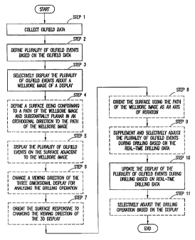
1001031 Figure 5 depicts a method (550) for performing a
drilling operation of an
oilfield. The method may be performed using, for example, the system of
Figure 4. The method involves collecting data (502), coordinating and
formatting the oilfield data for real-time processing by a modeling tool
(506),
comparing the drilling data with the oilfield predictions (508), and
displaying
the oilfield data in real-time (514). The method may also optionally involve
transferring oilfield data to the modeling tool via at least one server (504),
storing the oilfield data in a repository (510), generating at least one
canvas
for selectively depicting the oilfield data (512), and adjusting the drilling
operation based on the comparison of the drilling data and the oilfield
predictions (518).
1001041 The oilfield data may be collected (502) from a variety
of sources. As
discussed with respect to Figures 3 and 4, data may be generated by sensors at
the wellsite or from other sources. The data is transferred to the modeling
tool. The data may be transferred directly to the modeling tool, or
transferred
to the modeling tool via at least one server (504). The data is then received
by the interface of the modeling tool.
[001051 The oilfield data is formatted for real-time processing
by a modeling
tool (506). The formatting components of the modeling tool may be used to
selectively queue the data and stream it through the system. The data is
28
= CA 02793811 2012-10-29
, 50866-35D
selectively grouped and timed to facilitate data flow in real-time. The data
is
also translated, synchronized, converted or otherwise formatted so that it may
be efficiently processed by the modeling tool.
1001061 Once formatted for real-time processing, a new
drilling plan may be
generated in real-time by selectively analyzing the oilfield data. The
formatted data is processed by the processing components of the modeling
tool. Preferably, certain types of data are processed so that the drilling
plan
and other data may be generated in real-time. The drilling data may then be
compared with oilfield predictions 508, such as a predefined earth model
and/or drilling plan. The data may be stored in the data repository (510).
1001071 The oilfield data (processed and/or processed) may be
used to generate
canvasses for selectively depicting the oilfield data (512). The oilfield data
is
collected and queued so that it may be displayed in real-time and according to
various formats for viewing by a user. The various canvases defme layouts
for visualization of the data. Data may be displayed in 2D or 3D as it is
collected. As the data is processed and various outputs, such as a drilling
plan
is generated, the processed data may also be displayed.
1001081 The processed data may be further analyzed. In one
example, the real-
time drilling plan may be compared with a predefined earth model. The
predefined earth model is typically a plan that is created before the well is
drilled for planning oilfield operations, such as the drilling operation. The
drilling plan and the earth model may be adjusted based on the drilling data
collected. The real-time drilling data may suggest alternative action is
necessary to meet the requirements of the oilfield predictions. If so, a
decision may be made to adjust the drilling operation based on the real-time
data (516).
1001091 Figure 6A shows a screen shot of a exemplary 3D
display representing
multiple oilfield events. The 3D display (500) includes the wellbore image
(501), the subterranean formation image A (503), the subterranean formation
image B (505), and icons (i.e., graphical depictions such as colored strip,
29
CA 02793811 2012-10-29
,
, 50866-35D
colored ribbon, colored diamond, or the like) representing the oilfield events
(507). The term "icon" is used interchangeably with the term "graphical
depiction" throughout this document. The 3D display (500) may be a static
display representing historic data of a prior drilling operation or a dynamic
display representing a drilling operation in progress. In the case of the
dynamic display, the wellbore image (501) and the icons representing the
oilfield events (507) may be updated in real-time as the drilling tool
advances
into the subterranean formation represented by the subterranean formation
image A (503) and image B (505). The 3D display (500) may be provided by
the data rendering unit (436) and presented at the display unit (416) as
described in reference to Figure 4 above.
[00110] As depicted in Figure 6A, the icons representing the
oilfield events
(507) are configured as a billboard-like object positioned about the wellbore
image (501) in the 3D display (500). As an example, a portion of the wellbore
image and the icons representing the oilfield events are obscured by the
subterranean formation images. The data rendering unit (436) may be provided
with a mechanism to adjust the viewing angle of the 31) display such that the
obscured portion of the wellbore image and the icons representing the oilfield
events may be revealed. Further, the data rendering unit (436) may be
provided with a mechanism to orient the icons representing the oilfield events
in the 3D display according to the adjusted viewing angle. For example, the
icons representing the oilfield events may be oriented by rotating the
billboard
like object using the wellbore image as an axis of rotation. More details of
the
icons representing the oilfield events (507) is shown in Figure 6B.
[00111] Figure 6B shows an exemplary representation of
multiple oilfield events
arranged on a surface of the billboard as shown in Figure 5. Here, track A
through track G (621-627) are spaces allocated as containers for holding
oilfield event icons such as the oilfield event icon A through oilfield event
icon
D (631-634). Each of track A through track G runs parallel to and is located
away from the wellbore image (603) by a track offset. For example, oilfield
CA 02793811 2012-10-29
, 50866-35D
event icon A through oilfield event icon D are placed in track A (621), track
B
(622), and track D (624), respectively. Track D (624) is located away from the
wellbore image (603) by the track offset (601).
[00112] The start depths of the oilfield events corresponding
to oilfield event
icon A through oilfield event icon C are indicated by the multiple arrows
originating from the start depth (605). The end depths of the oilfield events
corresponding to oilfield event icon A through oilfield event icon C are
indicated by the multiple arrows originating from the end depth (607).
[00113] Each of oilfield event icon A through oilfield event
icon C is shaped like
a ribbon in this example with the length of the ribbon representing the
expanse
of a certain depth of the corresponding oilfield event. The start measured
depth
and end measured depth of the oilfield event corresponding to the oilfield
event
icon D (634) are the same as indicated by a diamond shaped icon. While
shown in Figure 6B, the dividing lines may be optionally displayed between
tracks (e.g., track A through track G) or disabled between tracks (e.g.,
unlabeled tracks to the right of the wellbore image (603)). The icons
representing oilfield events placed on the left side and the right side of the
wellbore image on the billboard-like object are substantially symmetrical and
may be envisioned as a cross section of multiple concentric cylinders centered
around the wellbore trajectory.
[00114] As described in reference to Figure 4 above, the data
rendering unit
(436) performs a rendering algorithm calculation to provide one or more
displays for visualizing the data. For example, the rendering algorithm
calculation may arrange the placement of the oilfield event icons in the
following manner to optimize the clarity of the display.
[00115] First, the oilfield events selected for display may be
ranked according to
a ranking algorithm based on one or more of attributes of the oilfield events.
For example, the ranking may be according to the expanse of a certain depth
where the oilfield event with a longer depth extend is placed ahead of the
other
oilfield event with a shorter expanse of a certain depth in a sorted list. In
other
31
CA 02793811 2012-10-29
, 50866-35D
examples, the oilfield events may be ranked according to other weighted
combination of one or more selected attributes. Next, an ordered collection of
tracks are created with each extending, for example, from the top to the
bottom
along the wellbore image in the 3D display. Each of these ordered collection
= of tracks is positioned at increasing offsets from the wellbore image.
Then,
oilfield event icons are placed into these ordered collection of tracks
= sequentially according to the ranking of the corresponding oilfield
events in the
sorted list. In the example of the ranking based on the expanse of a certain
depth, the oilfield icon corresponding to the longest expanse of a certain
depth
is placed first in the track closest to the wellbore image. Other oilfield
event
icons are placed subsequently into closest available tracks to the wellbore
image without overlapping already placed oilfield event icons.
1001161 Further to the placement of the oilfield event icons,
the color, pattern, or
other characteristics of the icon may be configured to represents the
attributes
of the corresponding oilfield event. As described in reference to Figure 4
above, each oilfield event may include attributes such as start depth, end
depth,
type, category, severity, probability, description, mitigation, affected
personal,
or other types of attributes. These attributes may be represented in the
display
by the location, length, color, pattern, or other characteristics of the
oilfield
icons as shown in Figure 6B.
[001171 Figure 7 shows a screen shot showing a display (700)
of a wellbore
image A (750) and icons representing oilfield events configured as a billboard-
like object (710), as described in reference to Figure 6A above. The display
(700) may be provided by the data rendering unit performing the rendering
algorithm calculation, as described in reference to Figure 6B above. Each of
the
icons representing oilfield events are placed in one of the tracks running
parallel to the wellbore image A (750), such as track a through track f (751-
756), on the billboard-like object (710). Track a through track fare arranged
in
a similar fashion as described in Figure 6B above. The dividing lines between
tracks are disabled as shown in Figure 7 as opposed to the earlier exemplary
32
CA 02793811 2012-10-29
. .
50866-35D
screen shot. Further, track a (751) is shown with no icon placed inside, while
track b (752) and track c (753) are each is shown with only one icon placed
inside and having available space for placing additional icons. Such a display
is shown as a result of removing certain icons previously placed in track a
through track c (751-753) based on a selective adjustment when a user re-
selects the portion of a large number of oilfield events for display as
described
in reference to Figure 4 above.
[00118] Figure 8 shows a screen shot showing a display (800)
of the wellbore
image A (750) and the same icons representing oilfield events as described in
= Figure 7 above. Here, the icons representing oilfield events are
configured as a
compacted billboard-like object (810). The display (800) is shown as a result
of the data rendering unit (436) performing re-calculation of the rendering
algorithm in real-time for optimizing the clarity of the display.
[00119] Figures 9A shows an exemplary representation of
multiple oilfield
events in the 3D display (940). Figure 9A includes wellbore image C (900)
with three fin-like objects attached along the wellbore trajectory. Here, fin
X
(910), fin Y (920) and fm Z (930) together forms a variation of the billboard-
like object described above. Fin X (910) includes various tracks (901-905). In
the example shown in Figure 9A, each of the various tracks (901-905) includes
one oilfield event icon placed inside. Fin Y (920) and Fin Z (930) are
replicas
of Fin X (910) and are oriented at different angles around the wellbore
trajectory so as to be visible to a user as viewing angle of the 3D display
(940)
is changed.
[00120] Figures 9B shows a detail view of a section of the
exemplary
representation of multiple oilfield events of Figure 9A with the same
references
indicated for perspective.
[00121] Figure 10A shows a schematic diagram with an example
of a user
viewing a 3D display representing multiple oilfield events using multiple fin
arrangement. Here, user A (1001) views a 3D view A (1130) along a viewing
direction A (1110). The 3D view A (1130) is represented as a cross section
33
CA 02793811 2012-10-29
50866-35D
view A (1120) to illustrate the benefit of multiple fin arrangement. One
skilled
in the art will appreciate that as viewing direction A (1110) changes through
various viewing angles relative to the cross section view A (1120), oilfield
event icons placed on fin X (1010), fin Y (1020), or fin Z (1030) may be
visible
to the user A (1001).
[00122] Figure 1013 shows a schematic diagram with another example of
a user
viewing a 3D display representing multiple oilfield events using a rotating
billboard arrangement. Here, user B (1002) views a 3D view B (1330) along
viewing direction B (1310) and viewing direction C (1510). The 3D view 13
(1330) is represented as a cross section view B (1320) to illustrate the
benefit
of a rotating billboard arrangement. The cross section view B (1320) includes
a
duplicate set of wellbore image B (1200) and rotating billboard (1220)
corresponding to the viewing direction 13 (1310) and the viewing direction C
(1510), respectively for illustration purpose.
[001231 As described in reference to Figure 6A above, the data
rendering unit
(436) may be provided with a mechanism to orient the icons representing the
oilfield events in the 3D display according to an adjusted viewing angle. For
example, the icons representing the oilfield events may be oriented by
rotating
the rotating billboard (1220) using the wellbore image 13 (1200) as an axis of
rotation. As such, the rotating billboard (1220) is always presented to the
user
B (1002) at a viewing angle that allows a full view of the icons representing
the
oilfield events placed on the rotating billboard regardless of the viewing
direction.
[00124] Figure 11 shows a flow chart of a method for performing a
drilling
operation of an oilfield. The method may be performed using, for example,
the system of Figure 4. The method may involve collecting oilfield data, with
a portion of the oilfield data being real-time drilling data generated from
the
oilfield during drilling (Step 1), defining a plurality of oilfield events
based on
the oilfield data (Step 2), selectively displaying the plurality of oilfield
events
about a wellbore image of a display (Step 3), and updating the display of the
34
CA 02793811 2012-10-29
50866-35D
plurality of oilfield events during drilling based on the real-time drilling
data
(Step 10). The method may optionally involve supplementing or selectively
adjusting the plurality of oilfield events during drilling based on the real-
time
drilling data (Step 9), and selectively adjusting the drilling operation based
on
the display (Step 11).
[00125] The
display may optionally be a 3D display, in which case the method
may involve defining the surface conforming to a path of the wellbore image
and substantially planar in an orthogonal direction to the path of the
wellbore
image (Step 4), displaying the plurality of oilfield events on a surface
adjacent
to the wellbore image (Step 5), changing a viewing direction of the three
dimensional display for analyzing the drilling operation (Step 6), orienting
the
surface responsive to changing the viewing direction of the 3D display (Step
7) and orienting the surface using the path of the wellbore image as an axis
of
rotation (Step 8).
{001261 The
oilfield data may be collected (Step 1) from a variety of sources. As
discussed with respect to Figures 3 and 4, data may be generated by sensors at
the wellsite or from other sources. The data may be transferred to the
modeling tool (408 in Figure 4). The data may be transferred directly to the
modeling tool, or transferred to the modeling tool via at least one of the
servers (406 in Figure 4). The data is then generally received by the
interface
of the modeling tool.
[00127] The
oilfield data may be defined into oilfield events (Step 2) by the
processing modules (442 in Figure 4). Some oilfield events may represent
real-time oilfield data acquired during drilling for monitoring risks and
other
drilling events of the drilling operation. Other oilfield events may be
generated from historic data compiled at neighboring wellsites as lesson
learned or best practice references. A
portion of the oilfield events is
selected for display about an image of the wellbore trajectory (Step 3) to
support decision making in the drilling operation. Images of the earth model
representing subterranean formations and reservoirs surrounding the wellbore
CA 02793811 2012-10-29
50866-35D
trajectory may also be selected for display_ The display may be provided by
the data rendering unit (436 in Figure 4) in the modeling tool and presented
to
a user at the display unit (416 in Figure 4) in the surface unit.
100128] As the drilling tool advances into the subterranean formation,
a large
number of oilfield events are being added from the increasing amount of
oilfield data acquired by the downhole sensors (Step 9). The user may also,
from time to time, select (or re-select) the portion of oilfield events most
relevant for display (Step 9). The data rendering module may re-calculate the
rendering algorithm to adjust the placement of the oilfield events display in
real-time (Step 10). Desired course of action may be determined based on the
updated display to adjust the drilling operation (Step 11).
[00129] While these real-time oilfield events are being updated to the
display
(Step 10), a user may, from time to time, change the viewing direction of the
display to observe the wellbore trajectory penetrating the foimation toward
the reservoir without being obscured. The display of oilfield events may be
configured to be on a surface adjacent to the wellbore image (Step 5) where
the surface may be a billboard-like object attached to the image of the
wellbore trajectory (Step 4). The surface may also be arranged as multiple fin
structure to allow the oilfield events to be visible from all viewing
directions.
Alternatively, the billboard-like object may be rotated around the wellbore
trajectory image to present a full view of the oilfield events to the user as
the
viewing angle is changed (Steps 7, 8). The billboard-like object may be
rotated according to the changing viewing direction by the data rendering
unit.
1001301 Figure 12 shows a flow chait of a method for performing a
drilling
operation of an oilfield. The method may be performed using, for example,
the system of Figure 4.
[00131] The method involves collecting oilfield data, with a portion
of the
oilfield data being real-time drilling data generated from the oilfield during
drilling (Step 21), defining a plurality of oilfield events based on the
oilfield
36
CA 02793811 2012-10-29
. 50866-35D
data (Step 22), formatting a display based on a portion of the plurality of
oilfield events selected for the display (Step 23), and selectively
reformatting
the display in real-time responsive to supplementing the selected portion of
the plurality of oilfield events or selectively adjusting the selected portion
of
the plurality of oilfield events (Step 24).
[00132] The method may optionally involve including a first
oilfield event in the
portion of the plurality of oilfield events selected for the display, where
the
first oilfield event is defined based on the real-time drilling data or
historic
data (Step 25), formatting the display based on a ranking of the first
oilfield
event in the selected portion of the plurality of oilfield events (Step 27),
and
reformatting a portion of the display corresponding to the first oilfield
event
in real-time responsive to adding a second oilfield event to the selected
portion of the plurality of oilfield events or removing a third oilfield event
from the selected portion of the plurality of oilfield events (Step 28).
[00133] The method may also optionally involve displaying each
of the plurality
of oilfield events as an icon on a surface adjacent to a wellbore image of the
display (Step 26), defining each icon based on an attribute of each of the
plurality of oilfield events, where the attribute includes start depth, end
depth,
type, category, severity, or probability (Step 29), placing each icon on the
surface based on a ranking of the plurality of oilfield events, wherein the
ranking determines placement proximity of each icon relative to the wellbore
image (Step 30), defining location, length, color, or pattern of each icon
based
on the attribute of each of the plurality of oilfield events (Step 31),
allocating
a plurality of tracks on the surface, the plurality of tracks substantially
parallel
to a path of the wellbore image (Step 32), and placing each icon into one of
the plurality of tracks without overlapping (Step 33).
100134J The oilfield data may be collected (Step 21) from a
variety of sources.
As discussed with respect to Figures 3 and 4, data may be generated by
sensors at the wellsite or from other sources. The oilfield data may be
defined
into oilfield events (Step 22) by the processing modules (442 in Figure 4). A
37
CA 02793811 2012-10-29
= 50866-35D
portion of the oilfield events is selected for display (Step 23). For example,
a
user may, from time to time, add an oilfield event (e.g., representing a
lesson
learned or a best practice) to be displayed or remove an oilfield event that
is
no longer relevant. The data rendering unit (436 in Figure 4) may re-calculate
the rendering algorithm in real-time to re-format the display by creating a
space for the added oilfield event or by re-using spaces made available from
the removal of an oilfield event (Step 24). The result is a compacted format
that improves the clarity of the display.
[00135] For example, a first oilfield event may be added to
the display (700) of
Figure 7 from real-time oilfield data or historic data (Step 25). The first
oilfield event may be placed in track b (752). A second oilfield event may
have been removed from the display and left a vacant spot in track a (751).
The display (700) is reformatted in real-time (Step 28) by the data rendering
unit (436) to compact the billboard-like object (710) into the compacted
billboard object (810). The first oilfield event, for example having the
longest
expanse of a certain depth, is placed in the track a (751) using a rendering
algorithm based on ranking of the expanse of certain depths (Step 27).
[00136] The oilfield events may be defined in a variety of
formats, such as the
WITSML or the like. The oilfield events may have attributes such as start
depth, end depth, depth extend, type, category, severity, or probability
(Steps
29). The oilfield events may be represented in a display by icons having
locations, length, color, or patterns defined corresponding to the oilfield
attributes (Steps 31). The oilfield events may be ranked in an order for
placement purpose in formatting the display (Step 30). The icons
representing the oilfield events may be displayed on a surface adjacent to a
wellbore image (Step 26) and placed in parallel tracks along the wellbore
trajectory without overlapping each other (Steps 32, 33).
[00137] As the adjustments are made, the process may be
repeated. New oilfield
data is collected during the drilling process. The drilling data may be
38
CA 02793811 2012-10-29
50866-35D
monitored and new drilling plans generated and compared to the earth plan.
Further adjustments may be implemented as desired.
100138] The steps of the method are depicted in a specific order.
However, it
will be appreciated that the steps may be performed simultaneously or in a
different order or sequence. Further, throughout the method, the oilfield data
may be displayed, the canvases may provide a variety of displays for the
various data collected and/or generated, and he display may have user inputs
that permit users to tailor the oilfield data collection, processing and
display.
1001391 It will be understood from the foregoing description that
various
modifications and changes may be made in the preferred and alternative
embodiments of the present invention without departing from its true spirit.
For example, the method may be performed in a different sequence, and the
components provided may be integrated or separate.
[00140] This description is intended for purposes of illustration only
and should
not be construed in a limiting sense. The scope of this invention should be
determined only by the language of the claims that follow. The term
"comprising" within the claims is intended to mean "including at least" such
that the recited listing of elements in a claim are an open group. "A," "an"
and
other singular terms are intended to include the plural forms thereof unless
specifically excluded.
39