Note: Descriptions are shown in the official language in which they were submitted.
CA 02795340 2015-10-13
ARTIFACT REDUCTION IN ITERATIVE INVERSION OF GEOPHYSICAL DATA
CROSS-REFERENCE TO RELATED APPLICATION
[0001]
This application claims the benefit of U.S. Provisional Patent Application
61/332,463, filed May 7, 2010, entitled ARTIFACT REDUCTION IN ITERATIVE
INVERNSION OF GEOPHYSICAL DATA.
FIELD OF THE INVENTION
[0002] The
invention relates generally to the field of geophysical prospecting, and
more particularly to geophysical data processing. Specifically, the invention
pertains to
to
reducing artifacts in iterative inversion of data resulting from
approximations made in .the
inversion.
BACKGROUND OF THE INVENTION
[0003]
Geophysical inversion [1,2] attempts to find a model of subsurface properties
that optimally explains observed data and satisfies geological and geophysical
constraints.
There are a large number of well known methods of geophysical inversion. These
well
known methods fall into one of two categories, iterative inversion and non-
iterative inversion.
The following are definitions of what is commonly meant by each of the two
categories:
= Non-iterative inversion ¨ inversion that is accomplished by assuming some
simple background model and updating the model based on the input data.
This method does not use the updated model as input to another step of
inversion. For the case of seismic data these methods are commonly referred
to as imaging, migration, diffraction tomography or Born inversion.
= Iterative inversion ¨ inversion involving repetitious improvement of the
subsurface properties model such that a model is found that satisfactorily
explains the observed data. If the inversion converges, then the final model
will better explain the observed data and will more closely approximate the
actual subsurface properties. Iterative inversion usually produces a more
- -
CA 02795340 2012-10-03
WO 2011/139413 PCT/US2011/028345
accurate model than non-iterative inversion, but is much more expensive to
compute.
[0004] Two iterative inversion methods commonly employed in geophysics
are cost
function optimization and series methods. Cost function optimization involves
iterative
minimization or maximization of the value, with respect to the model M, of a
cost function
S(M) which is a measure of the misfit between the calculated and observed data
(this is also
sometimes referred to as the objective function), where the calculated data is
simulated with a
computer using the current geophysical properties model and the physics
governing
propagation of the source signal in a medium represented by a given
geophysical properties
model. The simulation computations may be done by any of several numerical
methods
including but not limited to finite difference, finite element or ray tracing.
Series methods
involve inversion by iterative series solution of the scattering equation
(Weglein [3]). The
solution is written in series form, where each term in the series corresponds
to higher orders
of scattering. Iterations in this case correspond to adding a higher order
term in the series to
the solution.
[0005] Cost function optimization methods are either local or global
[4]. Global
methods simply involve computing the cost function S(M) for a population of
models {Mi,
M2, M3, -} and selecting a set of one or more models from that population that
approximately minimize S(M). If further improvement is desired this new
selected set of
models can then be used as a basis to generate a new population of models that
can be again
tested relative to the cost function S(M). For global methods each model in
the test
population can be considered to be an iteration, or at a higher level each set
of populations
tested can be considered an iteration. Well known global inversion methods
include Monte
Carlo, simulated annealing, genetic and evolution algorithms.
Local cost function optimization involves:
1. selecting a starting model,
2. computing the gradient of the cost function S(M) with respect to the
parameters that describe the model,
- 2 -
CA 02795340 2012-10-03
WO 2011/139413 PCT/US2011/028345
3. searching for an updated model that is a perturbation of the
starting model in
the gradient direction that better explains the observed data.
This procedure is iterated by using the new updated model as the starting
model for another
gradient search. The process continues until an updated model is found which
satisfactorily
explains the observed data. Commonly used local cost function inversion
methods include
gradient search, conjugate gradients and Newton's method.
[0006] As discussed above, iterative inversion is preferred over non-
iterative
inversion, because it yields more accurate subsurface parameter models.
Unfortunately,
iterative inversion is so computationally expensive that it is impractical to
apply it to many
problems of interest. This high computational expense is the result of the
fact that all
inversion techniques require many compute intensive forward and/or reverse
simulations.
Forward simulation means computation of the data forward in time, and reverse
simulation
means computation of the data backward in time.
[0007] Due to its high computational cost, iterative inversion often
requires
application of some type of approximation that speeds up the computation.
Unfortunately,
these approximations usually result in errors in the final inverted model
which can be viewed
as artifacts of the approximations employed in the inversion.
[0008] What is needed is a general method of iteratively inverting
data that allows for
the application of approximations without generating artifacts in the
resulting inverted model.
The present invention satisfies this need.
SUMMARY OF THE INVENTION
[0009] A physical properties model gives one or more subsurface
properties as a
function of location in a region. Seismic wave velocity is one such physical
property, but so
are (for example) density, p-wave velocity, shear wave velocity, several
anisotropy
parameters, attenuation (q) parameters, porosity, permeability, and
resistivity. The invention
is a method for reducing artifacts in a subsurface physical property model
caused by an
approximation, other than source encoding, in an iterative, computerized
geophysical data
inversion process, said method comprising varying the approximation as the
iterations
progress. In one particular embodiment, the invention is a computer-
implemented method for
- 3 -
CA 02795340 2012-10-03
WO 2011/139413 PCT/US2011/028345
inversion of measured geophysical data to determine a physical properties
model for a
subsurface region, comprising:
(a) assuming a physical properties model of the subsurface region, said
model
providing values of at least one physical property at locations throughout the
subsurface
region;
(b) selecting an iterative data inversion process having a step wherein a
calculation is made of an update to the physical properties model that makes
it more
consistent with the measured geophysical data;
(c) making in said calculation an approximation that either speeds up the
selected
lo iterative data inversion process other than by source encoding, or that
works an accuracy
tradeoff;
(d) executing, using the computer, one cycle of the selected iterative data
inversion process with said approximation and using the physical properties
model;
(e) executing, using the computer, a next iterative inversion cycle,
wherein a
selection is made to either change some aspect of the approximation or not to
change it;
(0 repeating (e) as necessary, changing the approximation in some
or all of the
iteration cycles, until a final iteration wherein a selected convergence
criterion is met or
another stopping condition is reached; and
(g) downloading the updated physical properties model from the
final iteration or
saving it to computer storage.
[0010] In some embodiments of the invention, one or more artifact
types are
identified in inversion results as being caused by the approximation, and the
aspect of the
approximation that is changed in some or all iteration cycles is selected for
having an effect
on artifacts of the one or more identified artifact types. The effect on
artifacts may be such
that artifacts from one approximation do not add constructively with artifacts
from another
iteration cycle that uses an approximation with a changed aspect.
BRIEF DESCRIPTION OF THE DRAWINGS
- 4 -
CA 02795340 2012-10-03
WO 2011/139413 PCT/US2011/028345
[0011] The present invention and its advantages will be better
understood by referring
to the following detailed description and the attached drawings in which:
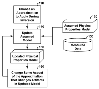
[0012] Fig. 1 is a flow chart showing basic steps in a general method
disclosed
herein;
[0013] Fig. 2 is a flow chart showing basic steps in a particular
embodiment of the
method of Fig. 1 wherein the objective function is approximated by encoding
and summing
the sources;
[0014] Figs. 3-5 pertain to an example application of the invention
embodiment of
Fig. 2:
[0015] Fig. 3 shows the seismic velocity model from which seismic data were
computed for the example;
[0016] Fig. 4 shows inversion of data from the seismic velocity model
in Fig. 3 using
the inversion method summarized in Fig. 2;
[0017] Fig. 5 shows inversion of data from the seismic velocity model
in Fig. 3 using
the inversion method summarized in Fig. 2 without the step in which the code
used to encode
the sources is changed between iterations;
[0018] Fig. 6 is a flow chart showing basic steps in a particular
embodiment of the
method of Fig. 1 wherein the approximation is varying the size of the grid
cells used in the
numerical inversion so as to use a fine grid only where needed;
[0019] Figs. 7-9 pertain to an example application of the invention
embodiment of
Fig. 6:
[0020] Fig. 7 is the seismic velocity model from which seismic data
were computed
for the example;
[0021] Fig. 8 shows an inversion of data from the seismic velocity
model in Fig. 7
using the inversion method summarized in Fig. 6;
- 5 -
CA 02795340 2015-10-13
[0022] Fig. 9 is an inversion of data from the seismic velocity model
in Fig. 7 using
the inversion method summarized in Fig. 6 without the step in which the depth
of the
artificial reflection generator is changed between iterations;
[0023] Fig. 10 is a flow chart showing basic steps in a particular
embodiment of the
method of Fig. 1, wherein the approximation is using only a subset of measured
data;
[0024] Figs. 11-13 pertain to an example application of the invention
embodiment of
Fig. 10:
[0025] Fig. 11 shows the seismic velocity model from which seismic
data were
computed for the example;
[0026] Fig. 12 shows an inversion of data from the seismic velocity model
in Fig. 11
using the inversion method summarized in Fig. 10; and
[0027] Fig. 13 shows an inversion of data from the seismic velocity
model in Fig. 11
using the inversion method summarized in Fig. 10 without the step in which the
subset of
measured data is changed randomly between iterations.
[0028] Due to patent constraints, Figs. 3-5, 7-9, and 11-13 are gray-scale
conversions
of color displays.
[0029] The invention will be described in connection with its
preferred embodiments.
However, to the extent that the following detailed description is specific to
a particular
embodiment or a particular use of the invention, this is intended to be
illustrative only, and is
not to be construed as limiting the scope of the invention. On the contrary,
it is intended to
cover all alternatives, modifications and equivalents.
DETAILED DESCRIPTION OF PREFERRED EMBODIMENTS
[0030] The present invention is a method for reducing artifacts caused
by the
application of approximations during iterative inversion of geophysical data.
Geophysical
inversion attempts to find a model of subsurface properties that optimally
explains observed
geophysical data. The example of seismic data is used throughout to illustrate
the inventive
- 6 -
CA 02795340 2012-10-03
WO 2011/139413 PCT/US2011/028345
method, but the method may be advantageously applied to any method of
geophysical
prospecting and any type of geophysical data. The data inversion is most
accurately
performed using iterative methods. Unfortunately iterative inversion is often
prohibitively
expensive computationally. The majority of compute time in iterative inversion
is spent
performing expensive forward and/or reverse simulations of the geophysical
data (here
forward means forward in time and reverse means backward in time). The high
cost of these
simulations is partly due to the fact that each geophysical source in the
input data must be
computed in a separate computer run of the simulation software. Thus, the cost
of simulation
is proportional to the number of sources in the geophysical data, typically on
the order of
1,000 to 10,000 sources for a geophysical survey. In typical practice,
approximations are
applied during the inversion to reduce the cost of inversion. These
approximations result in
errors, or artifacts, in the inverted model. This invention mitigates these
artifacts by changing
some aspect of the approximation between iterations of inversion so that the
artifact during
one iteration does not add constructively with the artifact in other
iterations. Therefore the
artifact is reduced in the inverted model.
[0031] Some common approximations made during iterative inversion that
result in
artifacts include:
1. Processing applied to the measured data
2. Inaccurate boundary conditions in the simulation
3. Approximations in the simulation (e.g. low order approximations of
derivatives used
in the simulator or the size of the grid cells used in the calculation)
4. Approximations in the parameterization of the model (e.g. use of a
spatial grid of
parameters that is too coarse to accurately represent variations in the
model).
Two iterative inversion methods commonly employed in geophysics are cost
function
optimization and series methods. The present invention can be applied to both
of these
methods. A summary of each of these methods follows next.
Iterative Cost Function Optimization
[0032] Cost function optimization is performed by minimizing the
value, with respect
to a subsurface model M, of a cost function S(M) (sometimes referred to as an
objective
- 7 -
CA 02795340 2012-10-03
WO 2011/139413 PCT/US2011/028345
function), which is a measure of misfit between the observed (measured)
geophysical data
and corresponding data calculated by simulation of the assumed model. A simple
cost
function S often used in geophysical inversion is:
Ng N, Nt
s(m)=E E E lvõ,,(1,g,r,t,wg)¨vobs(g,r,t,wgIN
(1)
g=1 r=1 t=1
where
N = norm for cost function (typically the least squares or L2-Norm is
used in which
case N= 2),
M = subsurface model,
g = gather index (for point source data this would correspond to the
individual
sources),
Ng = number of gathers,
r = receiver index within gather,
Nr = number of receivers in a gather,
t = time sample index within a data record,
Nt = number of time samples,
Kai, = calculated geophysical data from the model M,
globs = measured geophysical data, and
wg = source signature for gather g, i.e. source signal without earth
filtering effects.
[0033] The gathers in Equation 1 can be any type of gather that can be
simulated in
one run of a forward modeling program. For seismic data, the gathers
correspond to a
seismic shot, although the shots can be more general than point sources [5].
For point
sources, the gather index g corresponds to the location of individual point
sources. For plane
wave sources, g would correspond to different plane wave propagation
directions. This
- 8 -
CA 02795340 2012-10-03
WO 2011/139413 PCT/US2011/028345
generalized source data, vobs, can either be acquired in the field or can be
synthesized from
data acquired using point sources. The calculated data Kak on the other hand
can usually be
computed directly by using a generalized source function when forward modeling
(e.g. for
seismic data, forward modeling typically means solution of the anisotropic
visco-elastic wave
propagation equation or some approximation thereof). For many types of forward
modeling,
including finite difference modeling, the computation time needed for a
generalized source is
roughly equal to the computation time needed for a point source. The model M
is a model of
one or more physical properties of the subsurface region. Seismic wave
velocity is one such
physical property, but so are (for example) p-wave velocity, shear wave
velocity, several
m anisotropy parameters, attenuation (q) parameters, porosity, and
permeability. The model M
might represent a single physical property or it might contain many different
parameters
depending upon the level of sophistication of the inversion. Typically, a
subsurface region is
subdivided into discrete cells, each cell being characterized by a single
value of each
parameter.
[0034] One major problem with iterative inversion is that computing tit
, calc takes a
large amount of computer time, and therefore computation of the cost function,
S, is very
time consuming. Furthermore, in a typical inversion project this cost function
must be
computed for many different models M.
Iterative Series Inversion
[0035] Besides cost function optimization, geophysical inversion can also
be
implemented using iterative series methods. A common method for doing this is
to iterate
the Lippmann-Schwinger equation [3]. The Lippmann-Schwinger equation describes
scattering of waves in a medium represented by a physical properties model of
interest as a
perturbation of a simpler model. The equation is the basis for a series
expansion that is used
to determine scattering of waves from the model of interest, with the
advantage that the series
only requires calculations to be performed in the simpler model. This series
can also be
inverted to form an iterative series that allows the determination of the
model of interest,
from the measured data and again only requiring calculations to be performed
in the simpler
model. The Lippmann-Schwinger equation is a general formalism that can be
applied to all
types of geophysical data and models, including seismic waves. This method
begins with the
two equations:
- 9 -
CA 02795340 2012-10-03
WO 2011/139413 PCT/US2011/028345
LG = ¨I (2)
LOGO = ¨I (3)
where L, Lo are the actual and reference differential operators, G and Go are
the actual and
reference Green's operators respectively and I is the unit operator. Note that
G is the
measured point source data, and Go is the simulated point source data from the
initial model.
The Lippmann-Schwinger equation for scattering theory is:
G = Go + GOVG (4)
where V = L - Lo from which the difference between the true and initial models
can be
extracted.
lo 100361 Equation 4 is solved iteratively for V by first expanding
it in a series
(assuming G = Go for the first approximation of G and so forth) to get:
G = Go + GOVG0 + GOVG0VG0 + = = = (5)
Then V is expanded as a series:
V = V") + V(2) + V(3) + = = = (6)
where 11(n) is the portion of V that is Ilth order in the residual of the data
(here the residual of
the data is G - Go measured at the surface). Substituting Equation 6 into
Equation 5 and
collecting terms of the same order yields the following set of equations for
the first 3 orders:
G ¨ Go = GOV(1)G0 (7)
0 = G0V(2)G0 + G0V(1)G0V(1)G0 (8)
0 = G0V(3)G0 + G0V(1)G0V(2)G0 + G0V(2)G0V(1)G0 + GOV(1)GOV(1)GOV(1)G0 (9)
and similarly for higher orders in V. These equations may be solved
iteratively by first
solving Equation 7 for V(1) by inverting Go on both sides of V(1) to yield:
V(1) = G-01(G ¨ Go)G-01 (10)
- 10 -
CA 02795340 2012-10-03
WO 2011/139413 PCT/US2011/028345
V(1) from Equation 10 is then substituted into Equation 8 and this equation is
solved for 17(2)
to yield:
V(2) = ¨G-01GOV(1)GOV(1)G0G-01 (11)
and so forth for higher orders of V.
Equation 10 involves a sum over sources and frequency which can be written out
explicitly
as:
V(1) = EEGOAGs ¨Gos)Go-s) (12)
al S
where Gs is the measured data for source s, Go, is the simulated data through
the reference
model for source s and G0s-1 can be interpreted as the downward extrapolated
source
signature from source s. Equation 10 when implemented in the frequency domain
can be
interpreted as follows: (1) Downward extrapolate through the reference model
the source
signature for each source (the G0s-1 term), (2) For each source, downward
extrapolate the
receivers of the residual data through the reference model (the G0-1(Gs-G0)
term), (3)
multiply these two fields then sum over all sources and frequencies. The
downward
extrapolations in this recipe can be carried out using geophysical simulation
software, for
example using finite differences.
Example Embodiment
[0037] The flowchart of Fig. 1 shows basic steps in one embodiment of
the present
inventive method. In step 110, an approximation is selected that will improve
some aspect of
the inversion process. The improvement may be in the form of a speedup rather
than
increased accuracy. Examples of such approximations include use of an
approximate
objective function or use of an approximation in the simulation software.
These
approximations will often be chosen to reduce the computational cost of
inversion. However,
rather than a computational speed-up, the improvement may instead work an
accuracy trade-
off, i.e. accept more inaccuracy in one aspect of the computation in return
for more accuracy
in some other aspect. In step 140, an update to an assumed physical properties
model 120 is
generated based on the measured data 130. In step 140 the approximation chosen
in 110 is
used to perform the update computations. Using iterative local cost function
optimization as
- 11 -
CA 02795340 2012-10-03
WO 2011/139413 PCT/US2011/028345
an example of iterative inversion, the "update computations" as that term is
used herein
include, without limitation, computing the objective (cost) function, the
objective function
gradient, and all forward modeling required to accomplish the preceding. Step
140 produces
an updated physical properties model 150, which should be closer to the actual
subsurface
properties than were those of the assumed physical properties model 120.
Conventionally this
updated physical properties model 150 would be further improved by feeding it
and the
measured data 130 back into the update method in step 140 to produce a further
improved
physical properties model. This conventional iterative inversion method has
the disadvantage
that any artifacts in the inversion that result from the approximation chosen
in step 110 will
likely reinforce constructively in the inversion and contaminate the final
inverted result.
[0038] Rather than directly returning to step 140, the present
inventive method
interposes step 160 in which some aspect of the approximation chosen in step
110 is changed
in a manner such that the artifact caused by the approximation will change and
therefore not
be reinforced by the iterations of step 140. By this means the artifact
resulting from the
approximation chosen in step 110 will be mitigated.
Examples of approximations and corresponding arttfacts
[0039] The following table contains examples of step 110, i.e. of
approximations that
might advantageously be used in data inversion, and that are suitable (step
160) for
application of the present invention. The first column of the table lists
approximations that
could be used with this invention. The second column lists the artifact
associated with each
approximation. The last column lists a feature of the approximation that could
be varied
between iterations to cause a change in the artifact between iterations that
will cause it to add
incoherently to the final inverted model and thus be mitigated.
Approximation Artifact Features to vary
Encoded simultaneous Cross-talk noise between Vary the encoding of the
source seismic data [6] the encoded sources sources [ref 6, claim 3]
Use of a subset of Footprints of source Vary randomly the subset
measured data position in the inverted of measured data
models caused by source
- 12 -
CA 02795340 2012-10-03
WO 2011/139413
PCT/US2011/028345
positions
Imperfect absorbing Inaccuracy at the edges of Vary the thickness of the
boundary condition in the the inverted models caused absorbing boundary layer
simulator by artificial reflections
from the edges
Use of reflecting Inaccuracy at the edges of Vary the reflecting
boundaries in the simulator the inverted models caused boundary condition type
by artificial reflections (e.g. vary between Dirchlet
from the edges or Neumann boundary
conditions)
Use of random boundary Inaccuracy at the edges of Vary the distribution of
the
conditions in the simulator the inverted models caused random boundary
[7] by artificial reflections
from the edges
Spatial variation of size of Errors at the boundaries Vary the location of
the
grid cells in a finite between changes in the boundaries separating
difference simulator grid cell size caused by regions with different
grid
artificial reflections from cell sizes
those boundaries
Spatial variation of the Errors at the boundaries Vary the location of
the
accuracy of the simulation between changes in the boundaries separating
operator simulator's operator regions with different
accuracy caused by operator accuracies
artificial reflections from
those boundaries
Use of a grid cell size in Spatial discretization Vary
the grid cell size or
the simulation that is too errors the origin of the grid
coarse to accurately
represent variations in the
- 13 -
CA 02795340 2012-10-03
WO 2011/139413 PCT/US2011/028345
model
Use of a large time step in Discretization errors Vary the time step
interval
a time domain simulator
The above list is not exhaustive. The list includes examples only of
approximations that
reduce computation time. Sometimes it is advantageous to trade inaccuracy in
one area to
gain more accuracy in another. An example of such an accuracy tradeoff type of
approximation is to use less accurate absorbing boundary conditions in the
forward modeling
in order to make the gradient computations more accurate. Absorbing boundary
conditions
are needed to solve the differential equation(s) governing the wave
propagation, e.g. the
anisotropic visco-elastic wave propagation equation (or some approximation
thereof) in the
case of seismic data, or Maxwell's equations in the case of electromagnetic
data. In general,
an accuracy tradeoff involves sacrificing accuracy in one aspect of the method
in return for
increased accuracy in another aspect.
Test Example 1 ¨ Encoded Objective Function
[0040] Figures 2-5 represent a synthetic example of performing
inversion using an
approximation to the objective function in which the seismic sources in the
measured data are
encoded then summed; see U.S. Application Publication No. 2010-0018718 by
Jerome Krebs
et al. This approximation speeds up the inversion, because the encoded
objective function
can be evaluated using one run of the simulation software rather than running
it once for each
source as is the case for conventional inversion. Figure 2 is a self-
explanatory flow chart that
focuses Fig. 1 on this particular embodiment, with step 210 showing the
encoding
approximation.
[0041] The geophysical properties model in this example is just a
model of the
acoustic wave velocity. Figure 3 shows the base velocity model, i.e., the
"unknown" model
that will be inverted for and which was used to generate the data to be
inverted).for this
example. The shading indicates the velocity at each depth and lateral
location, as indicated
by the "color" bar to the right. Figure 4 shows the inversion resulting from
application of this
invention as summarized by the flow chart in Fig. 2. In this example the
sources are encoded
- 14 -
CA 02795340 2012-10-03
WO 2011/139413 PCT/US2011/028345
by randomly multiplying them by either plus or minus one. The encoding of the
sources is
changed, in step 260, by changing the random number seed used to generate the
codes used
to encode the sources. Note the good match to the base model shown in Fig. 3.
[0042] Figure 5 shows the result of applying the inversion method
outlined in the
flowchart in Fig. 2, but eliminating the inventive feature of step 260. Note
the inversion in
Fig. 5 is dominated by crosstalk noise (the speckled appearance of the
inversion), whereas
this crosstalk noise artifact is largely invisible in the inversion resulting
from the present
invention (Fig. 4).
[0043] Encoding of simultaneous sources was previously disclosed (and
claimed) in
U.S. Application Publication No. 2010-0018718 by Jerome Krebs et al. along
with the
technique of varying the encoding from one iteration to the next; see
paragraph 62 and claim
3 in that patent publication. However, U.S. Application Publication No. 2010-
0018718 by
Jerome Krebs et al. neither appreciates nor discloses that the encoding
invention is a specific
example of the generic invention disclosed herein.
Test Example 2 ¨ Approximation that generates an artificial reflection
[0044] Figures 6-9 illustrate a synthetic example of performing
inversion using an
approximation to the simulator that generates an artificial reflection. An
example of such an
approximation is using a finite difference simulator such that the size of the
cells in the grid
are changed with depth from the surface. This approximation speeds up the
inversion,
because the grid in the simulator could be adjusted to optimize it in a depth
varying manner.
Typically smaller grid cells are required for the shallow portion of a finite
difference
simulator than are required deeper in the model. The artifact generated by
this approximation
is an artificial reflection at the boundaries between changes in the grid cell
size.
[0045] Figure 6 is a flow chart for the embodiment of the present
invention illustrated
in this example. In this example, a variable grid simulator was not actually
used to generate
the artificial reflector. Instead (step 610) an artificial reflection is
generated by placing a
fictitious discontinuity in the density model at 500 meters depth. This
discontinuous density
model was used by the simulator for model updating, but a constant density
model was used
to generate the measured data (630 in Fig. 6). Inversion is then performed in
a manner such
- 15 -
CA 02795340 2012-10-03
WO 2011/139413 PCT/US2011/028345
that only the velocity model is updated (640), so that the fictitious density
discontinuity
remains throughout the iterations of inversion.
[0046] The geophysical properties model in this example is just a
model (620) of the
acoustic wave velocity. Figure 7 shows the base velocity model (the model that
will be
inverted for and which was used to generate the data to be inverted) for this
example. The
shading indicates the velocity at each depth. Figure 8 shows the inversion
resulting from
application of the present invention as summarized by the flow chart of Fig.
6. In this
example, in step 660, the depth of the fictitious density contrast is randomly
changed using a
normal distribution centered on 500 meters and with a variance of 100 meters.
Note the good
match to the base model shown in Fig. 7. In Figs. 7-9 and 11-13, velocity is
plotted as a
dimensionless relative velocity equal to the inverted velocity divided by an
initial velocity,
the latter being the starting guess for what the velocity model is expected to
be.
[0047] Figure 9 shows the result of applying the inversion method
outlined in the
flowchart of Fig. 6, but eliminating the inventive feature that is step 660.
It may be noted that
the inversion in Fig. 9 has a clearly visible artificial reflection 910 at 500
meters depth,
whereas this artificial reflection is largely invisible in the inversion that
used the present
inventive method (Fig. 8).
Test Example 3 ¨ Random subsets of measured data
[0048] Figures 10-13 represent a synthetic example of performing
inversion using an
approximation to the measured data. An example of such an approximation is
using a subset
of the measured data (1010 in Fig. 10). This approximation reduces the amount
of measured
data, which speeds up the inversion, because the computational time of the
inversion is
directly proportional to the number of measured data. In a typical inversion,
all of the
measured data are needed to maintain a high horizontal resolution, and thus in
typical
practice this approximation is not used. The artifact generated by this
approximation is
footprints in the inverted models caused by sparse source positions and
degradation of the
horizontal resolution. Figure 10 is a flow chart that focuses the steps of
Fig. 1 on the
embodiment of the invention used in this example. In this example, a subset of
the measured
data (1030 in Fig. 10) is used in the inversion, e.g. a subset of 5 data among
50 measured
data.
- 16 -
CA 02795340 2015-10-13
[0049] The
geophysical properties model in this example is just a model of the
acoustic wave velocity. Figure 11 is the base velocity model (the model that
will be inverted
for and which was used to generate the data to be inverted) for this example.
The shading
indicates the velocity at each depth. Figure 12 is the inversion resulting
from application of
this invention as summarized by the flow chart in Fig. 10. In this example, in
step 1060, a
subset of the measured data is randomly selected as inversion iteration
increases. This results
in a different subset of the data being used in each iteration cycle. Figure
12 shows a good
match to the base model shown in Fig. 11 using ten percent of the measured
data.
[0050]
Figure 13 shows the results of applying the inversion method outlined in the
flowchart in Fig. 6, but eliminating the inventive, artifact-reducing step
1060. It may be noted
that the inversion in Fig. 13 has artificial footprints at deeper parts below
2000 meters and
short wavelength noises in the overall inverted model, whereas this footprint
noises are
mitigated in the inversion using the presnt inventive method (Fig. 12), and
the short
wavelength noises are invisible.
[0051] It should be understood that the flow charts of Figs. 2, 6 and 10
represent
examples of specific embodiments of the invention that is described more
generally in Fig. 1.
[0052] The
foregoing patent application is directed to particular embodiments of the
present invention for the purpose of illustrating it. It will be apparent,
however, to one skilled
in the art, that many modifications and variations to the embodiments
described herein are
possible. Persons skilled in the art will readily recognize that in practical
applications of the
invention, at least some of the steps in the present inventive method
(typically steps 140-160,
and often generating the model in 120) are performed on a computer, i.e. the
invention is
computer implemented. In such cases, the resulting updated physical properties
model of the
subsurface may either be downloaded or saved to computer storage. The scope of
the claims
should not be limited by particular embodiments set forth herein, but should
be construed in a
manner consistent with the specification as a whole.
References
I.
Tarantola, A., "Inversion of seismic reflection data in the acoustic
approximation,"
Geophysics 49, 1259-1266 (1984).
- 17 -
CA 02795340 2012-10-03
WO 2011/139413 PCT/US2011/028345
2. Sirgue, L., and Pratt G. "Efficient waveform inversion and imaging: A
strategy for
selecting temporal frequencies," Geophysics 69, 231-248 (2004).
3. Weglein, A. B., Araujo, F. V., Carvalho, P. M., Stolt, R. H., Matson, K.
H., Coates, R.
T., Corrigan, D., Foster, D. J., Shaw, S. A., and Zhang, H., "Inverse
scattering series and
seismic exploration," Inverse Problems 19, R27-R83 (2003).
4. Fallat, M. R., Dosso, S. E., "Geoacoustic inversion via local, global,
and hybrid
algorithms," Journal of the Acoustical Society of America 105, 3219-3230
(1999).
5. Berkhout, A. J., "Areal shot record technology," Journal of Seismic
Exploration 1,
251-264 (1992).
6. Krebs, Jerome et al., "Iterative Inversion of Data from Simultaneous
Geophysical
Sources", U.S. Patent Application Publication No. 2010-0018718 (01-28-2010).
7. Clapp, R. G., "Reverse time migration with random boundaries," SEG
International
Exposition and Meeting (Houston), Expanded Abstracts, 2809-2813 (2009).
- 18 -