Note: Descriptions are shown in the official language in which they were submitted.
CA 02795529 2012-10-03
WO 2011/149771 PCT/US2011/037306
NETWORK LOCATION AND SYNCHRONIZATION OF PEER SENSOR
STATIONS IN A WIRELESS GEOLOCATION NETWORK
CROSS-REFERENCE TO RELATED APPLICATIONS
[0001] This application claims the benefit of U.S. Patent Application No.
12/786,166, filed May 24, 2010, the disclosure of which is incorporated herein
by reference
in its entirety.
TECHNICAL FIELD
[0002] The present invention relates generally to methods and apparatus for
locating
wireless devices, also called mobile stations (MS), such as those used in
analog or digital
cellular systems, personal communications systems (PCS), enhanced specialized
mobile
radios (ESMRs), and other types of wireless communications systems. More
particularly, but
not exclusively, the present invention relates to the geolocation and time
synchronization of
blocked and/or blind, impaired sensor stations in geolocation networks via a
wireless intra-
sensor communications network.
BACKGROUND
[0003] First commercially deployed in 1998, overlay network-based wireless
location systems have been widely deployed in support of location-based
services including
emergency services location.
[0004] Iterative geolocation of a radio emitter through the use of TDOA may
include the use of a single portable geolocation (e.g., TDOA) sensor, a pair
of portable
geolocation sensor stations and three of more portable geolocation sensor
stations. Adding
portable geolocation sensor stations to the iterative process reduces the
constraints on the
signals to be located as well as providing a reduction in the number of
iterations required to
obtain improved location accuracy.
[0005] Passively determining the location of a transmitter requires that
characteristics of its signal be measured at a number of distinct, and known,
locations by
sensor stations. This requires that the locations of the sensor stations in
the geolocation
network be known (e.g., each sensor station knows its own location or a
central controller
knows the location of each sensor station) and are time synchronized to each
other, i.e. they
-1-
CA 02795529 2012-10-03
WO 2011/149771 PCT/US2011/037306
operate on a common time base. The required precision of this time base is
dependent on the
location technique used.
[0006] Additionally, the sensor stations should provide the transmitter's
signal
characteristics (e.g. timing, power, angle, signal quality) to a central node,
via a
communication network, where they can be processed, along with the locations
of the sensor
stations, to determine the transmitter's location.
[0007] The location of sensor stations can be determined by a number of means
including manual surveys, use of an internal Global Navigation Satellite
System (GNSS)
timing receiver or reception of transmissions from stationary transmitters of
known location
(e.g., a commercial or governmental timing beacon or a time and frequency
stable
transmissions such as those from High-Definition Television (HDTV)
transmitters).
However, in some impaired environments (e.g., where one or more sensor
stations are
blocked or blind), none of these techniques is available for determining the
location of a
sensor. A wireless communication network is often used for communications
between the
sensor stations and this wireless communication network can serve a dual
purpose for sensor
stations that are not able to determine their location with other techniques.
In this
specification, the terms GNSS and Global Positioning System (GPS) will be used
interchangeably.
[0008] The inventive techniques and concepts described herein apply to well
known
wireless systems, which include the widely deployed time and frequency
division
multiplexed (TDMA/FDMA) radio communications systems including the widely used
Global System for Mobile communications (GSM) and OFDM-based wireless systems
such
as Long Term Evolution (LTE), WiMAN (IEEE-802.16) and WiMAX (IEEE-802.20), as
well as code-division radio communications systems such as CDMA (IS-95, IS-
2000) and
Universal Mobile Telecommunications System (UMTS), the latter of which is also
known as
W-CDMA. Further background information may be obtained from U.S. Patent No.
7,616,155, November 10, 2009, "Portable, Iterative Geolocation of RF
Emitters," the
disclosure of which is hereby incorporated by reference in its entirety.
SUMMARY
[0009] With proper design of the wireless communications waveform, a sensor
that
is not able to determine its location with other techniques can determine its
location by
reception of communications signals from at least three other sensor stations
in the
geolocation network that have determined their location and synchronized their
clocks with
-2-
CA 02795529 2012-10-03
WO 2011/149771 PCT/US2011/037306
either GPS or reception of transmissions from stationary transmitters sited at
known
locations. Once all sensor locations are known and time synchronization is
accomplished
over the intra-sensor communications network, location of mobile devices using
radio
geolocation techniques can be performed with the geolocation network.
[0010] An illustrative embodiment of the present invention is employed in
connection with system for geo-locating transmitters of interest. The system
comprises a
network of geographically dispersed sensor stations including reference sensor
stations and
one or more blind sensor stations. The illustrative embodiment comprises a
plurality of
sensor stations, wherein at least three sensor stations are at a known
location and are
synchronized with a reference clock. The at least three sensor stations are
useful as reference
sensor stations. In addition, a central node is configured to control the
sensor stations and a
backhaul communications network is configured to permit wireless
communications among
the sensor stations and central node. The system is configured to employ the
backhaul
communications network and reference sensor stations for synchronization and
geo-location
of one or more blind sensor stations.
[0011] In another illustrative embodiment, a method for geo-locating
transmitters of
interest comprises determining the locations of at least three sensor stations
and
synchronizing the at least three sensor stations with a reference clock, and
employing
wireless communications via a backhaul wireless communications network to
synchronize
and geo-locate at least one blind sensor station. The wireless communications
include
broadcast by reference sensor stations of a wireless communications waveform
that is
received by the at least one blind sensor station and used for synchronization
and geo-
location.
[0012] In yet another illustrative embodiment, a method for geo-locating
transmitters of interest involves a network of geographically dispersed sensor
stations
including reference sensor stations and at least one deficient sensor station.
The deficient
sensor station is at an unknown location, is not synchronized with the
reference sensor
stations, and does not have a direct radio connection to three or more
reference sensor
stations. The inventive method comprises determining the locations of at least
three sensor
stations and synchronizing these with a reference clock, thereby making the at
least three
sensor stations useful as reference sensor stations. In addition, the method
employs wireless
communications via a backhaul wireless communications network to synchronize
and geo-
locate a first deficient sensor station. This includes a broadcast by the
reference sensor
stations of a wireless communications waveform that is received by the first
deficient sensor
-3-
CA 02795529 2012-10-03
WO 2011/149771 PCT/US2011/037306
station and used for synchronization and geo-location. In addition, in
preferred
implementations, the first deficient sensor station makes a transmission time
measurement for
every sensor station to which it has a direct connection via the wireless
backhaul
communications network, including one or more reference sensor stations and at
least one
other deficient sensor station. Moreover, the at least one other deficient
sensor station makes
transmission time measurements for every sensor station to which the at least
one other
deficient sensor station is directly connected via the backhaul wireless
communications
network.
[0013] This summary is not intended to cover all of the inventive concepts
described herein, and therefore other aspects of illustrative embodiments of
the present
invention are described below.
BRIEF DESCRIPTION OF THE DRAWINGS
[0014] The foregoing summary as well as the following detailed description is
better understood when read in conjunction with the appended drawings. For the
purpose of
illustrating the invention, there is shown in the drawings exemplary
constructions of the
invention; however, the invention is not limited to the specific methods and
instrumentalities
disclosed. In the drawings:
[0015] Figure 1 graphically depicts transmitter geolocation via uplink or
downlink
signal based ranging utilizing time or power geolocation techniques.
[0016] Figure 2 graphically depicts transmitter geolocation via time and/or
power
difference of arrival geolocation techniques via uplink or downlink signals.
[0017] Figure 3 illustrates location of a blind sensor station when obstructed
from
satellite positioning.
[0018] Figure 4 depicts location of a transmitter using both sensor stations
positioned by satellite positioning and sensor stations positioned by the
sensor network.
[0019] Figure 5 shows direct communications between the central node and the
sensor stations.
[0020] Figure 6 shows a mixed network for sensor stations either in direct
communications with the central node or sensor stations relayed through
intermediate
stations.
[0021] Figure 7 schematically depicts the major subsystems in an embodiment of
a
portable sensor station(s).
-4-
CA 02795529 2012-10-03
WO 2011/149771 PCT/US2011/037306
[0022] Figure 8 depicts the functional elements within a sensor station's
multi-
channel, tunable wideband digital receiver and signal processor subsystem.
[0023] Figure 9 depicts the functional elements within a sensor station's
diversity
timing, location and frequency synchronization receiver subsystem.
[0024] Figure 10 depicts the functional elements within an embodiment of a
central
node.
[0025] Figure 11 depicts the mathematical basis for the location determination
and
time synchronization of a blind or deficient sensor station.
[0026] Figure 12 shows an example of the initialization of a sensor station in
the
geolocation network.
DETAILED DESCRIPTION OF ILLUSTRATIVE EMBODIMENTS
[0027] We will now describe illustrative embodiments of the present invention.
First, we provide a detailed overview of the problem and then a more detailed
description of
our solutions.
[0028] A network of sensor stations can use Power-of-Arrival (POA), Power-
Difference-of-Arrival (PDOA), Time-of-Arrival (TOA), Time-Difference-of-
Arrival (TDOA)
or hybrids of TOA, POA, TDOA, PDOA and/or Angle-of-Arrival (AoA) to geolocate
wireless transmitters in two dimensions when three or more sensor stations in
the network
receive the transmitter's signal and the sensor stations are at known
locations and are time
synchronized. A precise synchronization between all sensor stations is
required to enable the
time based methods, including Time-of-Arrival (TOA) or Time-Difference-of-
Arrival
(TDOA) methods. A relatively imprecise common time base suffices for the Power-
of-
Arrival, Power-Difference of Arrival (PDOA) and Angle of Arrival (AOA)
methods. Hybrid
methods combining a time and power, time and angle, or time power and angle
require
precise time synchronization. Use of more than three sensor stations that
receive the signal in
the location solution increases the accuracy of the location estimate. The
Global Navigation
Satellite Systems, such as the NavStar Global Positioning System (GPS)
satellite system, is
often used by the sensor stations to determine their location as well as
synchronize them in
time and frequency. However, the GPS receiver in a sensor station requires a
fairly
unobstructed view (minimally attenuated, reflected, refracted signal path) of
multiple
satellites to determine its location as well as get time and frequency
synchronized. Many
environments do not permit the reception of a sufficient number of GPS
satellites to permit
some sensor stations in the network to determine their location or synchronize
in time. These
-5-
CA 02795529 2012-10-03
WO 2011/149771 PCT/US2011/037306
sensor stations can receive transmissions from other sensor stations that know
their own
location (or whose locations are known by the system) and are time
synchronized to a
common clock. The sensor stations in the location network that know their
location and are
time synchronized are known as "reference" sensors or reference sensor
stations.
[0029] The sensor stations that do not have knowledge of their own location
and are
not time synchronized are known here as "blind" sensor stations. Sensor
stations that cannot
communicate directly to the central node are known here as "blocked" sensor
stations. A
sensor station that can communicate directly with the central node is a
"direct" station. A
"deficient" sensor station is "blind" and does not have a direct radio
connection to three or
more reference sensor stations. Blocked applies to the communications path
while deficient
applies to the radio paths.
[0030] In an illustrative system in which the present invention may be
deployed,
sensor stations are able to determine their location and synchronize their
time clock with all
of the other sensor stations in the geolocation network. This can be achieved
by incorporating
GPS location and timing receivers into the sensor or an equivalent location
and timing
receiver based upon terrestrial signals. If these signals cannot be received
by a sensor then it
is "blind" and must utilize another technique to determine its location and
achieve time
synchronization with the geolocation network. The backhaul communications
network can be
designed to overcome this disadvantage through the use of "reference" sensor
stations, i.e.
sensor stations that can determine their position and synchronize in time
through the use of
GPS or terrestrial signals. The reference sensor stations act, in essence, as
pseudolites to the
blind sensor stations. Blind sensor stations that have a direct radio
connection to three or
more reference sensor stations can, therefore, self locate and achieve time
synchronization
with the geolocation network. Blind sensor stations that do not have a direct
radio connection
to three or more reference sensor stations, i.e. they are "deficient", but do
have an indirect
connection to three or more reference stations may be able to be located and
synchronized to
the geolocation network by providing information on signals it can receive
from the direct
connection to its neighbors to the central node. The central node will process
information
from all of the sensors in the geolocation network, determine the location of
blind ones and
time synchronize them to the geolocation network. In effect, the wireless
backhaul network
serves two purposes. The first purpose is to provide communications
connectivity to all
sensor stations in the geolocation network so that they may be controlled by a
central node
and provide the data they collect to the central node. The second purpose is
to permit blind
-6-
CA 02795529 2012-10-03
WO 2011/149771 PCT/US2011/037306
sensor stations to determine their location and achieve time synchronization
through
connectivity to reference sensor stations.
[0031] A wireless geolocation network employs a central node to control the
sensor
stations and to receive the measurements the central node commanded them to
make. The
central node operates upon these measurements to determine a location
estimate. The central
node also acts as the interface to external systems that trigger geolocations
and displays the
resulting location estimate. Any particular sensor station can also act as the
central node. The
sensor station that is the central node can also change over time.
[0032] A wireless geolocation system is typically triggered to determine the
location of a transmitter's signal. Typically, the trigger will specify the
time(s) and
frequencies at which the sensor stations will acquire the transmitter's
signal. It may also
specify other parameters to identify the signal of interest. For example, in
CDMA systems
this could be the spreading code(s). The trigger could come from an external
source. For
example, the wireless network the transmitter is operating on. The location
trigger could also
be determined by the central node or one of the sensor stations. As another
example, a sensor
that receives a signal above a specified power level at a specific frequency
and time period
could generate a trigger to all of the other sensor stations in the
geolocation network. See,
e.g., U.S. Patent Publication US 2006/0003775 Al, "Advanced Triggers for
Location-based
Service Applications in a Wireless Location System," filed on June 10, 2005.
[0033] The location of fixed reference sensor stations can also be determined
with a
manual survey. Time synchronization for a fixed reference sensor can be
achieved by
receiving the transmissions from at least one GNSS satellite or from a
geostationary Wide
Area Augmentation System (WAAS) or from a ground-based, terrestrial timing
signal from a
known location. A GNSS receiver provides this functionality. GNSS receivers
solve for 4
unknowns; Latitude, Longitude, Altitude and Time. When less than 4 satellite
broadcasts are
available, the GNSS (e.g. GPS) receiver can still produce a highly accurate
timing signal and
frequency reference provided one satellite signal (GNSS or WAAS) is available
and the
receiver location and altitude is precisely known.
[0034] Although the use of power-difference-of-arrival (PDOA) and time-
difference-of-arrival (TDOA) are used as operative examples throughout this
specification,
some or all sensor stations may also be equipped with Angle-of-Arrival (AOA)
equipment
and functionality. Use of AOA, time-of-arrival (TOA) and power-of-arrival
(POA)
techniques in the location calculation of either the sensor station or mobile-
of-interest (MOI)
are also not precluded. (The terms "mobile-of-interest" and "transmitter-of-
interest" are used
-7-
CA 02795529 2012-10-03
WO 2011/149771 PCT/US2011/037306
herein to refer to transmitters whose locations are to be determined, e.g., by
a wireless geo-
location system. The term "mobile" implies that the transmitter is not
necessarily at a fixed
location. In some cases, a mobile transmitter may be a portable unit or even a
fixed unit used
intermittently.) Hybrids of all the discussed location techniques are likely
to be implemented
in a deployed geolocation network. Frequency Difference of arrival (FDOA) will
be
implemented to compensate for moving sensor stations and moving mobiles of
interest.
Additionally, some geolocation techniques, such as POA and PDOA, do not
require
extremely accurate time synchronization between sensor stations.
[0035] The term "cell site" is used as a generic term to describe a
transmission site
or beacon used when the signal collection is performed at the mobile device (a
downlink-
based location system). A cell site may be a dedicated facility or the radio
access network
(RAN) subsystem of a wireless communications network (WCN). A cell site may
also have a
co-located or integrated sensor station to collect signals for an uplink-
signal wireless location
technique.
[0036] Figure 1 is a geographical illustration of the unique location
determination of
a mobile transmitter via Power-of-Arrival (POA) or Time-of-Arrival (TOA)
geolocation
techniques. The unique location of the mobile device 101 is illustrated by the
common
intersection of the three circles 102 103 104. The range circles 102 103 104
are each centered
upon each of the three geographically separated sensor stations 105 106 107.
The perimeter
of each circle 102 103 104 represents a range (a contour of constant distance)
from each
sensor station 105 106 107.
[0037] POA ranges and the transmitter's location are derived by measuring the
power and utilizing a propagation model to calculate the radial distance the
transmitter is
from each of the sensor stations.
[0038] TOA geolocation ranges and a location are derived by measuring time
delays
and using the speed of radio wave propagation to calculate the radial distance
the transmitter
is from each of the sensor stations. When sensor stations are precisely
synchronized,
geolocation based on TOA with a constant time offset (as is used in the GPS
system) is
possible.
[0039] Figure 2 is a graphical illustration of the unique location
determination of a
mobile transmitter via a PDOA or TDOA geolocation technique. A set of
geographically
distinct sensor stations 205 206 207 is shown. The unique location of the
mobile device 201,
i.e. the transmitter, is illustrated by the common intersection of hyperbolas.
Each hyperbola
202 203 204 represents a contour of constant differences in distance from the
pair of sensor
-8-
CA 02795529 2012-10-03
WO 2011/149771 PCT/US2011/037306
stations located at the foci of the hyperbolas. For PDOA this is derived by
measuring the
difference in power between the pair of sensor stations at the foci and
converting this power
difference to a distance difference with a propagation model. For TDOA this is
derived by
measuring the difference in time the mobile's signal is measured at the pair
of sensor stations
at the foci and converting this to distance using the speed of radio wave
propagation.
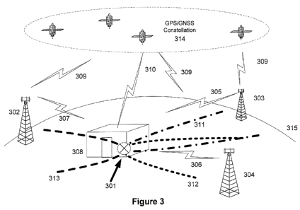
[0040] Figure 3 illustrates how a single "blind" sensor 301 can determine its
own
location and time synchronize to the other sensor stations in the network 302
303 304 by
receiving wireless signals 305 306 307 from at least three "reference" sensor
stations 302 303
304 that know their location and are time synchronized to the geolocation
network. In the
Figure 3 illustration, time synchronization and self-location are determined
at each reference
station 302 303 304 from unobstructed satellite-broadcast navigation signals
309 provided by
the satellite constellation 314.
[0041] The blind sensor 301 cannot access the attenuated or obstructed
satellite-
provided radio signals 310 provided by the satellite constellation 314 and
must rely upon an
alternative technique to determine its location and synchronize in time. In
effect, the
"reference" sensor stations act as pseudolites to the "blind" sensor via the
wireless backhaul.
[0042] Two fundamental requirements of the sensor stations for the
illustrative
wireless geolocation system described herein include knowledge of their
locations and time
synchronization. Both of these requirements can be satisfied by including a
GPS timing
receiver with each sensor. GPS timing receivers receive the signals from GPS
satellites
orbiting the earth to determine their location and provide a time and
frequency reference.
However, GPS satellite signals levels are low and can be attenuated by
obstructions which
prevent their use. The wireless communications system employed for inter-
sensor
communications can be used to determine the location of the sensor that cannot
receive GPS
as well as synchronize it in time.
[0043] The pseudolite concept is taught in US Patent Serial No. 6,771,625 and
US
Patent Serial 6,101,178, both entitled, "Pseudolite-augmented GPS for locating
wireless
telephones". Both of these patents are held by the assignee of this
application.
[0044] Ground-based reference sensor stations act as pseudolites to support
accurate
determination of sensor locations by broadcasting CDMA signals interleaved by
a TDMA
system. Pseudolites synchronize signal transmissions with an accurate timing
reference, such
as can be derived from GPS satellites. Adjacent pseudolites broadcast CDMA
signals at
different times, eliminating near-far signal interference between pseudolites.
Blind sensor
stations receive and determine the TOA of the pseudolite signals. A location
processor
-9-
CA 02795529 2012-10-03
WO 2011/149771 PCT/US2011/037306
associated with the blind sensor may access an internal database of pseudolite
locations, or
pseudolite geo-location information may be encoded in pseudolite
transmissions. The
location processor uses pseudolite geo-location information and TOA to
determine sensor
locations and time synchronize them to the geolocation network. The TDMA
pseudolite-
based system may augment the GNSS (such as GPS) to provide more accurate geo-
location
information than is available from the GNSS alone.
[0045] Figure 4 illustrates an example deployment of a portable iterative
geolocation system with mixed reference and blind sensor stations. Figure 4
illustrates
reference sensor stations that can receive GPS signals and a blind sensor that
cannot receive
GPS signals but can determine its location and synchronize in time via three
reference sensor
stations it can receive via it wireless backhaul. Additionally, it shows the
central node getting
an external location trigger and all of the sensor stations in the geolocation
network receiving
the signal-of-interest (SOI) and providing characteristics of it to a central
node (not shown)
which calculates and displays the location and provides it to an external
entity.
[0046] The multiple sensor stations are distributed about a geographic area to
receive the signal transmitted by the target. The geometric arrangement of
these sensor
stations with respect to the transmitter to be located, i.e. the target, will
impact the accuracy
with which the target can be located. This is called the Geometric Dilution of
Precision
(GDOP). Best accuracy is obtained when the sensor stations completely surround
the target.
The minimum number of sensor stations that must receive the signal from the
transmitter is
three for a two dimensional location estimate and four for a three dimensional
location
estimate (if mobile transmitter's time of transmission is unknown). Location
accuracy can be
further improved when more than the minimum required sensor stations can
receive the
transmitter's signal and participate in the location through the use of an
over-determined
solution. Sensor stations must know their location when acquiring the target's
signal. Static
sensor stations' locations can be manually surveyed or a GPS receiver can be
incorporated
into the sensor to accurately determine their location. Other geolocation
receivers that utilize
digital TV broadcasts can be used as well. Sensor stations that utilize these
auxiliary receivers
to determine their location can, therefore, be portable. For time based
geolocation techniques
the sensor stations must be accurately time synchronized and acquire the
signal from the
target either simultaneously or iteratively (as described in U.S. Patent No.
7,616,155).
Auxiliary receivers in the sensor stations can also synchronize the sensor
stations in time.
[0047] In Figure 4, the GNSS constellation 401 provides satellite broadcasts
408
allowing many of the deployed sensor stations 402 403 404 405 to self locate
and
- 10-
CA 02795529 2012-10-03
WO 2011/149771 PCT/US2011/037306
synchronize to a common system time such as an offset from Greenwich Mean Time
(GMT)
or Coordinated Universal Time (UTC). Some sensor stations 407 are obstructed
(in this
example, by the building structure 406) from receiving a sufficient number of
satellite signals
409 to self-locate or time synchronize. These blind station(s) 407 can then be
located by
network means (as shown in Figure 3) and still contribute to the locating of
the mobile
transmitter 410 in a wireless communications network 414. In the Figure 4
illustration,
TDOA with its superior performance in an urban environment is shown with TDOA
hyperbolas 411 412 413 intersecting at the geographic location of the mobile
device 410.
[0048] An example wireless geolocation network deployment is shown in Figure 4
and is comprised of: Multiple reference sensor stations; Blind sensor stations
(any sensor
stations without sufficient radio signals to self-determine position or timing
from the GNSS
constellation, WAAS, or terrestrial broadcast networks), Backhaul
Communications System,
Central Processing Node/External Interface, Display/Control Device.
[0049] Sensor stations in a wireless geolocation system must possess a
communications method so that they can be controlled, i.e. commanded, to
receive the signal
from the transmitter at a specific time, as well as provide the
characteristics of the signal
received to a common, central node where they can be processed to determine
the
transmitter's location. Ideally, a "star" communications topology, as shown in
Figure 5 would
provide communications signaling 504 505 506 507 508 509 510 511 between the
fixed
sensor stations 512 515 518 519, mobile sensor stations 513 514 516 517 and
the central node
501. The central node 501 here is shown as a central host computation platform
502 and a
wireless transceiver station 503 allowing server 502 to be located either
locally or remote to
the wireless transceiver station 503. Not shown are the display, database
storage and
collateral information available at the central node. For instance, the
central node may have
an associated Location Intelligence Management System (LIMS) (see U.S. Patent
Application No. 12/642,058, filed December 18, 2009, "Location Intelligence
Management
System") either locally or remote and connected via a wide-area-network. The
LIMS is a data
capture, storage and decision support system that utilizes available data
(both past and real
time) from multiple sources (such as wireless networks, wireless location
network, and off
line sources such as network information, geographic information, manually
entered
information and geo-spatial data) to optimize utilization (scheduling and
selection) of
wireless location resources across multiple users and entities to produce
location-aware
intelligence. The LIMS contains the algorithms, control logic, data storage,
processors and
input/output devices to analyze past and real time data obtained from multiple
sources in
-11-
CA 02795529 2012-10-03
WO 2011/149771 PCT/US2011/037306
combination or separately, to produce intelligence in the form of metadata not
otherwise
reasonably or easily obtained. These algorithms can iteratively use previous
generated
metadata to automatically contribute to new analysis, which will use both real
data (past and
real time) as well as metadata. Such analysis would produce information such
as: identifying
potential behaviors of interest, identifying specific mobile users associated
with such
behaviors of interest, associations between mobile device users and mobile
device user
identification when no public ID is available (such as with prepaid mobile
devices).
[0050] Often, however, a wireless communications backhaul is utilized for
portability and the central node may not have direct wireless connectivity to
all of the sensor
stations. This disadvantage can be overcome through the use of a mesh
communications
network as shown in Figure 6 where sensor stations that have connectivity with
both the
central node and sensor stations that cannot see the central node can act as a
relay.
[0051] Figure 6 illustrates how in real world environments the central node
may not
be able to communicate directly with all of the sensor stations in the
geolocation network, i.e.
some sensor stations are "blocked" ones. A mesh communications network,
however,
provides a path, via relay, through sensor stations that the central node does
have a direct
communications connection with, providing daisy-chained communications between
blocked
sensor stations and the central node.
[0052] In the example deployment depicted, the server 602 in the central node
601
uses its associated transceiver facility 603 to communicate with the deployed
sensor stations.
Direct links 612 613 614 615 616 are formed between the central station 601
and the
unblocked stations 604 607 608 609 611. Using the databased knowledge of the
deployed
sensor stations and the direct radio link(s), the central server 602 then
orders all directly
connected sensor stations 604 607 608 609 611 to conduct a search of the air
interface for the
missing, presumed blocked sensor stations 605 606 610. Once the
missing/blocked sensor
stations 605 606 610 are discovered, the discovering sensor acts as a relay
between the
central node 601 and the formerly missing stations. A relay may be one-hop
with the
discovering station 609 the only intermediary between the blocked station 610
and the central
node. A relay may be multi-hop with multiple intermediate stations 607 606 a
blocked station
605 and the central node 601. A relay may have multiple connections where the
blocked
station 605 can use or select from the best of multiple relay connections 618
620 621.
[0053] A sensor in a geolocation network will typically need to know its
location
and synchronize in time with the other sensor stations in the geolocation
network when
acquiring the signal of the transmitter to be located. A block diagram of a
sensor is shown in
-12-
CA 02795529 2012-10-03
WO 2011/149771 PCT/US2011/037306
Figure 7. The portable sensor 701 is comprised of a number of antennas 702 703
704,
receivers 707 706 and transceiver 705, internal communications links between
the
subsystems 708 709 711 712 713 and an optional controller and display device
711 with
interconnection between the subsystems via internal digital communications
links 710. The
high sensitivity diversity timing receiver/server 707 receives GNSS signals
from satellites
above the earth or from terrestrial broadcast stations (either purpose built
systems or with
high uptime quality of service such as High definition television (HDTV)
stations), to enable
the determination of the location of the sensor and provide time and frequency
synchronization for the sensor when these signals are available. The RF
signals from the
transmitters that are to be located are received with the signal antenna and
provided to the
multichannel tunable wideband digital receiver and signal processor. Once the
signals are
acquired they can be processed with the signal processor and the results
provided to the
central node. A mesh network communications transceiver provides
communications
between the sensor and other sensor stations including the central node. When
a sensor
knows it location and is time synchronized to the common clock of the
geolocation network it
can serve as a pseudolite for blind sensor stations that it can communicate
with directly. The
controller and display devices permit control of the sensor and display of its
location, location
of other sensor stations as well as locations of targets on a map or other
overhead image.
[0054] The multichannel tunable wideband digital receiver and signal processor
is
the central subsystem of the sensor station. The block diagram of the
functional elements of a
representative Multichannel Tunable Wideband Digital Receiver and Signal
Processor
Subsystem 801 of the Sensor station is depicted in Figure 8. The functional
elements depicted
are: Radio Frequency/Intermediate Frequency (RF/IF) subsystem 803, Analog to
Digital
conversion subsystem (A/D) 804, First Memory Buffer subsystem 805, Digital
down
converter (DDC) subsystem 806, Second Memory Buffer subsystem 807, Digital
Signal
Processing (DSP) subsystem 808, Control Processor subsystem 809, and Clock
distribution
subsystem 810. The receiver antenna(s) connection(s) 802 are shown, but the
receiver
antenna are not.
[0055] The RF/IF subsystem 803 converts multiple channels of RF signals 802 to
an
intermediate frequency (IF) signal 811. RF/IF subsystem 803 does this by
accepting RF
signals 802 from antenna(s), bandpass filters them to reject signals outside
of the appropriate
RF band they are operating and then amplifying the remaining signals. The
remaining signals
are then translated in frequency to an intermediate frequency where they are
again filtered
with a bandpass filter to reject unwanted mixing components and noise. The
resultant signals
-13-
CA 02795529 2012-10-03
WO 2011/149771 PCT/US2011/037306
are again amplified with a buffer amplifier before being input to the next
stage. The multiple
channels may receive the same set of RF frequencies from multiple antennas or
receive a
different sent of RF frequencies from one or multiple antennas. This, for
example, would
permit reception of both uplink and downlink signals of a wireless
telecommunications
network. Often, the downlink signals of a wireless telecommunications network
are
monitored to synchronize to the timing of it. The RF/IF subsystem may possess
a single local
oscillator that is driven by the frequency reference or multiple local
oscillators, as many as
one per channel, again tied to the frequency reference for frequency
stability.
[0056] The processed signals 811 from the RF/IF subsystem 803 are input to the
Analog-to-Digital Conversion (A/D) subsystem 804. The A/D subsystem 804
possesses an
A/D converter for each received radio channel. All of the A/Ds are clocked
simultaneously
with the sampling clock derived from the frequency and time reference. Each
A/D will
convert the analog signal from a channel of the RF/IF subsystem 803 to a
digital format with
each sample comprising a number of bits. The multiple channels of digital
samples 812 are
provided to a first memory buffer 805 which can provide a configurable amount
of delay
between its input and output. Optionally, the first memory buffer 805 can be
configured as a
circular ring buffer.
[0057] The digital downconverter (DDC) subsystem 806 accepts multiple channels
of wideband digital samples 813 that are centered at the intermediate
frequency and translates
them to baseband in-phase and quadrature samples that have been further
bandpass filtered,
translated in frequency and their output sample rate reduced. In effect, the
DDCs permit
tuning to specific channels of specified bandwidth with the sample rate
reduced to be more
consistent with the channel bandwidth. The DDC subsystem 806 will possess
multiple DDCs.
There may be a one-to-one correspondence between the number of DDCs and the
RF/IF
channels. Or there can be multiple DDCs assigned to a single RF/1F channel
permitting the
reception of multiple narrowband frequency channels derived from a single
wideband RF/IF
channel. The digital output 814 of the DDC subsystem 806 inputs a second
memory buffer
807. The multiple channels of digital samples 814 are provided to the second
memory buffer
807 which can provide a configurable amount of delay between its input and
output.
Optionally, it can act as a circular buffer to permit geolocation of transient
signals after they
have occurred.
[0058] The DSP subsystem 808 takes the digital samples 815 from the buffer
memory 807 as produced by the DDC subsystem 806, and processes the samples in
various
ways. The types of processing can include:
-14-
CA 02795529 2012-10-03
WO 2011/149771 PCT/US2011/037306
o Detection
o Demodulation
o Correlation
o Spreading/Despreading
o Coding/decoding
o Equalization
o Signal Reconstruction
o Location determination
[0059] The control processor subsystem 809 acts as the external interface 820
to the
outside world for the sensor station, receiving and sending commands and
information
through the receiver's internal digital interfaces 817 818 819. Additionally,
control processor
subsystem 809 configures each of the subsystems in the receiver 801 as well as
other
subsystems in the sensor station.
[0060] Synchronization of time and, optionally, frequency between the sensor
stations is important for geolocation. The clock synchronization subsystem 810
accepts the
time and frequency reference provided by either the timing receiver, for a
reference sensor, or
from the central node via the mesh communications transceiver if a blind
sensor, and
generates the required timing signals 816 for the other subsystems within the
receiver 801.
[0061] Additionally, control processor subsystem 809 configures each of the
subsystems in the receiver as well as the timing receiver/server and the mesh
communications
transceiver.
[0062] The major functional elements of the diversity timing, location and
frequency synchronization receiver subsystem used in both the sensor stations
and central
node is depicted in Figure 9. A diversity receiver (Time and Frequency
Synchronization
Unit) 901 generates position, time and frequency references for use in
locating and
synchronizing the sensor stations in the geolocation network. As shown in
Figure 9, the
diversity receiver 901 a satellite broadcast receiver 902 with associated
antenna 904 and a
second receiver subsystem comprising a terrestrial broadcast receiver 903 with
associated
antenna 905 and a common processor platform (CPP) 906 coupled via control 911
and data
912 digital links to the satellite broadcast receiver 902 and to the
terrestrial broadcast receiver
903 via control 913 and data 914 digital links. The CPP in turn is associated
with a reference
oscillator 907 the CPP trains via control link 915 and reads via data link
916.
[0063] The diversity receiver 901 is served by at least one antenna array,
preferably
one antenna 904 905 for each receiver 902 903.
-15-
CA 02795529 2012-10-03
WO 2011/149771 PCT/US2011/037306
[0064] The satellite broadcast receiver subsystem 902 provides a stable time
reference and signal information used for positioning to the CPP via the data
912 digital
link(s). The terrestrial broadcast receiver 903 also provides time reference
and signal
information used for positioning to the CPP using associated the digital data
link(s) 914.
[0065] The CPP, in turn, uses the signal information provided by the satellite
902
and terrestrial receivers 903 to formulate the system time, frequency
references and location
data for the diversity receiver 901. Data links output the system time 908,
frequency
reference(s) 909 and location data 910 to the other subsystems of the sensor
station or central
node.
[0066] In a more specific illustrative embodiment of the diversity receiver,
the
terrestrial broadcast receiver comprises a HDTV receiver. The terrestrial
broadcast receiver
subsystem may include an antenna for receiving an aiding signal communicating
aiding
information including broadcaster locations, channel assignments and timing
characteristics
and parameters. Alternatively, or in addition, the terrestrial broadcast
receiver may include an
aiding information interface for receiving aiding information including
broadcaster locations,
channel assignments and timing characteristics and parameters. In this
example, aiding
information interface is configured to couple the terrestrial receiver to a
landside aiding
server or network.
[0067] In a further illustrative embodiment, the diversity receiver further
comprises
a second receiver subsystem comprising a GNSS receiver operatively coupled via
third link
means to the CPP. The second receiver subsystem provides a second stable time
and
frequency reference and position information to the CPP via the third link
means. The GNSS
receiver may include an aiding information interface for reception of a GNSS
aiding signal
providing satellite constellation orbital information and other information
used to correct for
clock drift, atmosphere signal delay, and ionosphere delay, which are used to
enhance the
sensitivity, time-to-first-fix TFFF and accuracy of a GNSS receiver's location
estimate and
the time and frequency references. In addition, the GNSS receiver may include
an aiding
information interface for receiving aiding information from a landside aiding
server or
network. Moreover, the GNSS receiver may be configured to operate in a static
timing mode
in which a time and frequency reference are provided when the sensor knows its
location,
perhaps from a manual survey, and only one GNSS satellite signal is available,
and the CPP
may be configured to designate a primary and secondary receiver subsystem
based on time-
to-fix, signal quality, or operator preference.
-16-
CA 02795529 2012-10-03
WO 2011/149771 PCT/US2011/037306
[0068] In yet a further illustrative embodiment, the diversity receiver
includes a
reference oscillator operatively coupled to the CPP, and the CPP is configured
to
communicate with the first and second receiver subsystems, to receive stable
time signals
from the receiver subsystems, and to use at least one of the time signals to
discipline the
reference oscillator. In addition, the CPP is further configured either to
select one of the first
and second receiver subsystems or to hybridize the information provided by the
receiver
subsystems to create an optimized time reference, frequency reference and
timestamp to be
provided to the sensor.
[0069] Figure 10 schematically details the major functional subsystems of the
central node 1001. The main function of the central node 1001 is the primary
controller of the
sensor stations in the geolocation network. The central node 1001 is very
similar in design to
a sensor station in that it possesses a high sensitivity diversity timing
receiver 1006, timing
server 1003 and mesh network communications transceiver/pseudolite elements
1004.
[0070] The location processor gateway (LPG) subsystem 1002 is unique to the
central node 1001 that maintains communication with each sensor in the
geolocation network
via either a direct wireless connection or via relays through other sensor
stations if it does not
have a direct wireless connection. The LPG 1002 monitors the state of each of
the deployed
sensor stations to determine if they are:
- Reference sensor or blind sensor
- Direct connection or Indirect connection to the central node
- Direct connection to three or more reference sensors
- Know their location
- Are time synchronized
- Status of Receiver and Signal processing resources
[0071] The location processor gateway 1002 initiates the geolocation of a
specific
transmitter via a message from its external interface from another external
node or from any
of the sensor stations in the network via a self-triggering mechanism. For
example, a signal
level threshold can be set of a particular RF channel for one or more of the
sensor stations. If
the signal level detected by the sensor stations exceeds the preset threshold
at a sensor then a
message is sent to the central node to trigger a geolocation of that
transmitter. The location
processor gateway of the central node will task the appropriate sensor
stations based upon
their status.
-17-
CA 02795529 2012-10-03
WO 2011/149771 PCT/US2011/037306
[0072] Whether a geolocation is triggered externally or internally the central
node
1001 will task the appropriate sensor stations to acquire the transmitter-of-
interest's signal,
measure the collected signal characteristics and provide the collected signal
and timing
information back to the central node 1002. The central node 1001 will
calculate the location
of the transmitter-of-interest and provide the calculated location to an
external entity, display
it locally and/or record it in a database (not shown) for future post-
processing.
[0073] Location determination and time synchronization of a blind sensor can
be
accomplished with knowledge of the distance the blind sensor is from three or
more reference
sensor stations. With this information a set of mathematical equations
simultaneously
expressing these distances as a function of the location of the blind sensor
can be solved.
These distances can be expressed mathematically for N reference sensor
stations, where N is
greater than 3, as:
d1 = (x1 - x)2 + (Yl - Y)2 + (z1 - Z)2
d2 = (x2 - x)2 + (Y2 - Y)2 + (z2 - z)2
dN = (xN - x)2 + (YN Y )2 + (ZN - Z)2
[0074] The locations of the reference sensor stations are (xi, yi, zi) for i
from 1 to N.
The location of the blind sensor is (x, y, z). There are many ways to solve
this set of equations
simultaneously. One common way is to minimize the sum of the squared
difference between
the measured distance, di, and the model for the distance which is a function
of the location (x
,y, z). The quantity, i.e. metric, to be minimized to determine (x, y, z) is
expressed
mathematically as:
12
(di - (xi-x)2+(Yi-Y)2+(zi-z)2 1
i=1
[0075] Graphically, the solution to this equation can be visualized as the
unique
intersection of three spheres centered on each of the reference sensor
stations with a radius
given as the distance from the respective reference sensor to the blind
sensor.
-18-
CA 02795529 2012-10-03
WO 2011/149771 PCT/US2011/037306
[0076] The distance a blind sensor is from a reference sensor can be
determined by
measuring the propagation time from a signal transmitted by the reference
sensor to the blind
sensor. This is the technique that GNSS (Global Navigation Satellite
System(s), such as the
existing United States Global Positioning System (GPS)) terminals use where
the GNSS
satellites, and pseudolites, embed their location and time of transmission
into the wireless
waveform that is transmitted to the terminal. The GNSS terminal then notes the
time, with
respect to its local clock, that the transmission was received. Since radio
waves propagate at
constant velocity the measured propagation time can be converted to a distance
by
multiplying by the speed of light, denoted c, which is the velocity of
propagation of radio
waves. This converted distance would be the correct distance from the
satellite to the terminal
if the satellite clock and terminal clock were time synchronized. But they are
not and,
therefore, a clock offset must be added to the variables that must be solved
for from the
measurements. This clock offset is common to all of the measurements.
Additionally, solving
for the clock offset effectively time synchronizes the blind sensor to the
reference sensor
stations. The equations are:
cT, = (x, - x)2 + (y. - y)2 + (z1- z)2 + C0
cT2 = (x2-x)2+(y2-y)2+(z2-z)2 +C0
cTN = (xN - x)2 + (YN .y)2 + (ZN - Z)2 + C'
[0077] Again, there are many ways these equations can be solved simultaneously
to
solve for the position of the blind sensor (x, y, z) and the local clock
offset CO. One common
way is to minimize the sum of the squared differences between the measured
distances plus
clock offset, cT,, and the model for the distance which is a function of the
location (x, y, z) of
the sensor and its clock offset Co. The quantity, i.e. metric, to be minimized
to determine (x,
y, z) and C0 is expressed mathematically as:
2
(CT - (xi - x)2 + (y - y)2 + (zi - z)2 1
- Ca J
-19-
CA 02795529 2012-10-03
WO 2011/149771 PCT/US2011/037306
[0078] Some blind sensor stations may not have direct wireless backhaul
connections to three or more reference sensor stations. In this event they are
described as
"deficient". However, the location of a deficient (a deficient sensor station
is a blind sensor
station with the added limitation of less than 3 radio connections) may still
be determined and
its time synchronized to the geolocation network by receiving wireless
backhaul
transmissions from other sensor stations and measuring the transmission time.
[0079] This deficient sensor scenario is depicted in Figure 11 for the two
dimensional TDOA case. Additional sensor stations and/or specialized antenna
equipment is
needed in the cases where a 3-dimensional location is desired or a hybrid
TDOA/AoA
technique is used.
[0080] In Figure 11, the reference sensor stations are depicted as a group
1101 1102
1103. The wireless connections between sensor stations, the wireless backhaul,
is also shown
1107 1108 1109 1110 1111 1112 1113 1114 1115. Using Figure 11 to illustrate,
the total
number of sensor stations in the geolocation network is six and there are
three reference
sensor stations and three blind sensor stations. Each deficient sensor makes a
transmission
time measurement from every sensor that it has a direct connection to as shown
in the Figure
11. Reference sensor clock offsets will be zero.
[0081] For example, sensor "6" 1106 is deficient and has direct connections
1108
1109 to reference sensor stations "a" 1101and "(3" 1102 and direct connections
1114 1115 to
deficient sensor stations "E" 1104 and "cp" 1105. Thus, four measurements can
be made with
this sensor 1106 and an equation derived for each relating the location(s) and
clock offset(s).
They are:
CTa S = lxa - xS JZ + (Ya - YS lZ + C5
2 2
cTf 5 = X - x9 + yfi - y~ + C9
CT,g= (xe-xsy +(ye - Ysy + C9-CE
cT,s = VFX~ Xg Y + (Y, - YgY +CS-C,
[0082] Since sensor stations "a" 1101 and "P" 1102 are reference sensor
stations
their locations, (xa, ya) and (xp, yb), are known and their clock offsets are
zero. Sensor stations
"6" 1106, "E" 1104 and "y" 1105 are deficient sensor stations so their
locations, (xs, ys), (xe,
-20-
CA 02795529 2012-10-03
WO 2011/149771 PCT/US2011/037306
ye), (xp, yp), are unknown as well as their clock offsets Cs, CE, and C..
Note, there are 9
unknowns in this set of four equations/measurements. There are not enough
equations to
determine uniquely the unknowns. This is remedied by making measurements with
deficient
sensor stations "E" 1104 and A p" 1105 with the sensor stations that they have
direct wireless
backhaul connections to. Doing so will yield eight more equations, some
redundant, but will
not introduce any more unknowns thereby providing sufficient information for
solving for the
unknowns uniquely.
[0083] There are many ways this set of equations can be solved simultaneously
for
the unknowns. One common way is to minimize the sum of the squared differences
between
the measured distance(s) plus clock offset(s), cT1,j, and the model for the
distance which is a
function of the locations (xj, yj) and clock offset(s) Cj. Mathematically,
when there is a total
quantity of M+N sensor stations, a quantity of M reference sensor stations and
a quantity of
N deficient sensor stations, this metric to be minimized can be written:
M+N Z
2 2
2
I cT,. j- JXxi) - (yj - yi) - G+Cj
il jeP(i)
where j c P(i) represents the set of sensor stations j that sensor i has
direct wireless backhaul
connection to.
[0084] Figure 12 depicts an example of sensor station initialization. The
sensor
station comes online 1201 and checks for stored configuration data 1202. The
stored
configuration data 1202 may be a static location or a last known location. The
availability or
validity of the last known location is tested 1203.
[0085] If the stored configuration data is deemed valid, then the sensor
station
attempts to determine the current system time 1207 from available satellite
(e.g. the GPS
system/WAAS) broadcasts or terrestrial navigation broadcasts. If the stored
configuration
data tests as invalid (flagged by operator, aged, incomplete, not entered,
etc.), then the sensor
station will attempt to self locate using its location receiver and any
available satellite
broadcasts 1204. If no valid location can be obtained 1205 from the stored
configuration or
via the satellite and terrestrial navigation broadcasts, then alternative
location means 1209 are
attempted. Alternative location means 1209 includes both wireless means (such
as using
commercial high-definition-television (HDTV) broadcasts or/or with other
terrestrial
beacons) or requesting manual entry of sensor station location. Optionally,
the sensor station
may acquire assistance information and retry self-location using satellite
broadcasts 1206
-21-
CA 02795529 2012-10-03
WO 2011/149771 PCT/US2011/037306
(Assisted-Global Navigation Satellite System positioning (A-GNSS)) and
terrestrial
navigation broadcasts (Wide Area Augmentation System (WAAS)).
[0086] If the sensor station location can be found using stored configuration
data,
satellite and/or terrestrial navigation broadcasts, or alternative location
means, and it has
achieved time synchronization the sensor station can be declared a reference
station 2010,
otherwise the station must be declared a blind station 1217 with no knowledge
of its own
location or time synchronization to the geolocation network.
[0087] If declared a reference station, the sensor station initializes its
wireless
transceiver and scans for other sensor stations 1212. All other stations
discovered are then
setup with direct connections 1213. The sensor station then 1214 connects the
central node.
The central node assesses 1215 the geolocation resource status of the sensor
station (e.g. the
accuracy of self-location, the signal quality of direct connections). The
central node then
declares the sensor station online 1216 and ready for participation in
location attempts.
[0088] If the sensor station was declared 1217 a blind sensor, the blind
sensor
station will then initialize 1218 its wireless transceiver and scan for other
sensor stations. Any
stations discovered by the blind sensor are then setup with direct connections
1219. The blind
sensor polls the discovered sensor stations for any that have been declared as
reference sensor
stations.
[0089] If a direct connection exists to three or more reference stations and
timing
references and location of each reference station is therefore known, then the
blind sensor
will receive the signals from the reference sensor stations 1221 and attempt
to self locate
using the signaling with the reference stations 1222. If the blind sensor
successfully locates
itself using the reference station signaling, then the blind sensor declares
itself a reference
sensor 1223. The reference sensor then establishes a connection to the central
node 1214. The
central node assesses 1215 the geolocation resource status of the sensor
station. The central
node then declares the sensor station online 1216 and ready for participation
in location
attempts.
[0090] If a sensor station has been declared blind 1217, can initialize a
wireless
backhaul 1218 and establish direction connections to other sensor stations
1219 but not to the
three or more reference stations required for self-location 1220, then the
blind sensor will
measure all connections 1224 and establish a connection to the central node
1225. The blind
sensor station will then provide the central node with measurements for each
direct
connection 1226. If the central node, using its knowledge of the timing and
location of each
sensor station, cannot develop a location and time-offset for the blind sensor
station, that
-22-
CA 02795529 2012-10-03
WO 2011/149771 PCT/US2011/037306
station is declared offline 1228. If a location and time-offset can be
determined for the blind
station, then the central node will assess the geolocation resource status
1215 for the sensor
station. The central node then declares the sensor station online 1216 and
ready for
participation in location attempts.
Conclusion
[0091] The true scope the present invention is not limited to the presently
preferred
embodiments disclosed herein. Accordingly, except as they may be expressly so
limited, the
scope of protection of the following claims is not intended to be limited to
the specific
embodiments described above.
-23-