Note: Descriptions are shown in the official language in which they were submitted.
CA 02796410 2012-10-15
WO 2011/146079 PCT/US2010/035883
SYSTEMS AND METHODS FOR
HORIZONTAL WELL CORRELATION AND GEOSTEERING
CROSS-REFERENCE TO RELATED APPLICATIONS
[0001] Not applicable.
STATEMENT REGARDING FEDERALLY SPONSORED RESEARCH
[0002] Not applicable.
FIELD OF THE INVENTION
[0003] The present invention generally relates to horizontal well
correlation and
geosteering. More particularly, the present invention relates to updating a
three-dimensional
("3D") modeled surface from a correlated two-dimensional ("2D") modeled
surface used to
guide (geosteer) the end of a horizontal section of a wellbore along a target
line to the target
formation.
BACKGROUND OF THE INVENTION
[0004] By some estimates, 80% of new oil and gas wells are horizontal wells.
Horizontal
wells are deviated wellbores, which include a horizontal section. Each of
these must be
accurately and efficiently geosteered because time is of the essence when
drilling expensive
deviated wellbores and a mistake in the geosteering (drilling) can be very
costly if not potentially
hazardous. Most geosteering applications are stand-alone 2D applications that
are not integrated
with a project database and 3D geo-model. In other words, they cannot take
advantage of what a
full 3D environment affords and it is difficult to incorporate the 2D
interpretation back into the
project database and geo-model. Most 2D geosteering applications must export
the horizontal
well correlation data in order to then import that data back into the project
database, which is a
time-consuming process. Additionally, conventional 2D geosteering applications
cannot display
1
CA 02796410 2012-10-15
WO 2011/146079 PCT/US2010/035883
a depth converted seismic backdrop that can be dynamically updated with new or
additional
seismic data. In fact, many conventional 2D geosteering applications cannot
support multiple
type logs (e.g. signature logs) that are used for correlating the horizontal
section of the wellbore
into variable geology. This deficiency can lead to inaccurate correlation and
incorrect
geosteering instructions.
[0005] TerraVurm is one example of a 2D geosteering application, which is
marketed by
Terra Domain Consulting, that is limited to a single type log for correlation
purposes. Moreover,
TerraVurm is a stand-alone 2D geosteering application that does not offer a
dynamic depth
converted seismic backdrop and must export its horizontal well correlation
data in order to read
that data into the project database.
[0006] Other geosteering applications like smartSECTION-rm and
BoreSight=rm contain
different limitations. For example, smartSECTION-rm, which is marketed by
Landmark Graphics
Corporation, has limited horizontal well correlation and geosteering
capability and does not
support 2D model building including apparent dip angle and fault offset
manipulation along the
we I lbore.
[0007] There is therefore, a need for a more efficient and accurate means to
guide the end
of a horizontal section of the wellbore to the target formation using 2D
and/or 3D modeled
surfaces.
SUMMARY OF THE INVENTION
[0008] The present invention meets the above needs and overcomes one or more
deficiencies in the prior art by providing systems and methods for guiding the
end of a horizontal
section of the wellbore to the target formation using a correlated 2D model to
update a 3D
model.
2
CA 02796410 2012-10-15
WO 2011/146079 PCT/US2010/035883
[0009] In one embodiment, the present invention includes a method for
geosteering a
wellbore, which comprises: a) initializing a 3D model and a 2D model using a
computer, the 3D
model representing an interpreted surface and the 2D model representing a
straight line; b)
initializing an actual LWD curve and a TVT curve, the actual LWD curve
representing formation
measurements taken from within the wellbore and the TVT curve being based on
the actual
LWD curve; c) initializing a TVT type log and a predicted LWD curve, the TVT
type log being
based on at least one of a dip or a fault offset for the 2D model and the
predicted LWD curve
being based on the TVT type log; d) adjusting at least one of the dip or the
fault offset for a
section of the 2D model until a segment of the predicted LWD curve
substantially matches a
corresponding segment of the actual LWD curve or until a segment of the TVT
curve
substantially matches a corresponding segment of the TVT type log, the segment
of the predicted
LWD curve that substantially matches the corresponding segment of the actual
LWD curve
representing a correlated segment; e) setting a marker at an end of the
correlated segment, the
marker separating a section of the 2D model that corresponds with the
correlated segment from a
remaining section of the 2D model; 0 repeating steps d) and e) for the
remaining section of the
2D model until an end of the wellbore is reached, the end of the wellbore
corresponding with an
end of the predicted LWD curve and an end of the actual LWD curve; g) updating
the 3D model
from the 2D model; and 11) analyzing the 3D model to determine if the wellbore
is on target.
[00010] In another embodiment, the present invention includes a program
carrier device
having computer executable instructions for geosteering a wellbore. The
instructions are
executable to implement: a) initializing a 3D model and a 2D model using a
computer, the 3D
model representing an interpreted surface and the 2D model representing a
straight line; b)
initializing an actual LWD curve and a TVT curve, the actual LWD curve
representing formation
3
CA 02796410 2012-10-15
WO 2011/146079 PCT/US2010/035883
measurements taken from within the wellbore and the TVT curve being based on
the actual
LWD curve; c) initializing a TVT type log and a predicted LWD curve, the TVT
type log being
based on at least one of a dip or a fault offset for the 2D model and the
predicted LWD curve
being based on the TVT type log; d) adjusting at least one of the dip or the
fault offset for a
section of the 2D model until a segment of the predicted LWD curve
substantially matches a
corresponding segment of the actual LWD curve or until a segment of the TVT
curve
substantially matches a corresponding segment of the TVT type log, the segment
of the predicted
LWD curve that substantially matches the corresponding segment of the actual
LWD curve
representing a correlated segment; e) setting a marker at an end of the
correlated segment, the
marker separating a section of the 2D model that corresponds with the
correlated segment from a
remaining section of the 2D model; f) repeating steps d) and e) for the
remaining section of the
2D model until an end of the wellbore is reached, the end of the wellbore
corresponding with an
end of the predicted LWD curve and an end of the actual LWD curve; g) updating
the 3D model
from the 2D model; and h) analyzing the 3D model to determine if the wellbore
is on target.
[00011] In yet another embodiment, the present invention includes a program
carrier
device for carrying a data structure, the data structure comprising: i) a
first data field comprising
of vertical section, the vertical section comprising a 3D model and a 2D
model, the 3D model
representing an interpreted surface and the 2D model representing a straight
line; ii) a second
data field comprising a horizontal panel, the horizontal panel comprising an
actual LWD curve
and a TVT curve, the actual LWD curve representing formation measurements
taken from within
a wellbore and the TVT curve being based on the actual LWD curve; and iii) a
third data field
comprising a vertical panel, the vertical panel comprising a TVT type log and
a predicted LWD
4
CA 02796410 2016-05-20
curve, the TVT type log being based on at least one of a dip or a fault offset
for the 2D model
and the predicted LWD curve being based on the TVT type log.
[00012] Additional aspects, advantages and embodiments of the invention will
become apparent to those skilled in the art from the following description of
the various
embodiments and related drawings.
BRIEF DESCRIPTION OF THE DRAWINGS
[00014] The present invention is described below with references to
the
accompanying drawings in which like elements are referenced with like
reference numerals,
and in which:
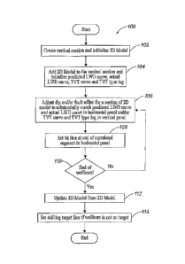
[00015] FIG. 1 is a flow diagram illustrating one embodiment of a
method for
implementing the present invention.
[00016] FIG. 2 illustrates a graphical user interface for displaying a
vertical
section, a horizontal panel and a vertical panel according to the present
invention.
[00017] FIG. 3 illustrates a graphical user interface for displaying
the vertical
section, the horizontal panel, the vertical panel and a dynamically depth
converted seismic
backdrop according to the present invention.
[00018] FIG. 4 illustrates a graphical user interface for adding a 2D
model to
the vertical section in FIGS. 2 or 3.
[00019] FIG. 5 is a schematic diagram illustrating the calculation of
a TVT
type log using a 2D and/or a 3D modeled surface.
CA 02796410 2016-05-20
[00020] FIG. 6 illustrates a graphical user interface for adjusting
the dip and/or
fault offset for a 2D model or a 3D model.
[00021] FIG. 7 illustrates a graphical user interface for displaying
the vertical
section, the horizontal panel and the vertical panel after the dip for a 2D
model in the vertical
section is adjusted.
[00022] FIG. 8A is a schematic diagram illustrating compression of a
TVT
type log interval after adjusting for relative negative dip of the 2D model.
[00023] FIG. 8B is a schematic diagram illustrating equivalent TVT and
TVD
type log intervals where the dip of the 2D model is flat.
[00024] FIG. 8C is a schematic diagram illustrating extension of the
TVT type
log interval after adjusting for relative positive dip of the 2D model.
[00025] FIG. 9 illustrates a graphical user interface for displaying
the vertical
section and a 3D model after it is updated from the 2D model.
[00026] FIG. 10 illustrates a graphical user interface for displaying
the vertical
section, the 3D model after it is updated and a drilling target line.
[00027] FIG. 11 is a block diagram illustrating one embodiment of a
system
for implementing the present invention.
DETAILED DESCRIPTION OF THE PREFERRED EMBODIMENTS
[00028] The subject matter of the present invention is described with
specificity, however, the description itself is not intended to limit the
scope of the invention.
The subject matter thus, might also be embodied in other ways, to include
different steps or
combinations of steps similar to the ones described herein. Moreover, although
the term
"step" may be used herein to describe different elements of methods
6
CA 02796410 2012-10-15
WO 2011/146079 PCT/US2010/035883
employed, the term should not be interpreted as implying any particular order
among or between
various steps herein disclosed unless otherwise expressly limited by the
description to a particu-
lar order. While the following description refers to the oil and gas industry,
the systems and
methods of the present invention are not limited thereto and may also be
applied to other indus-
tries to achieve similar results.
Method Description
[00029] Referring now to FIG. 1, a flow diagram illustrates one embodiment of
a method
100 for implementing the present invention. The method 100 represents a
workflow that may be
fully integrated with a project database and is supported by a full 3D
environment and topology
engine. As a result, geometry and log attribute information can be extracted
from a 3D model,
also referred to as a 3D modeled surface or a 3D geomodel, to generate
predicted logging-while
drilling ("LWD") log responses. Moreover, different type logs may be
incorporated into the
workflow as the horizontal section of the wellbore is extended into variable
geology. Actual
well logs represent formation measurements taken by logging instruments while
drilling a
wellbore. The formation measurements represent log responses, which are
typically illustrated in
the form of a curve.
[00030] In step 102, a vertical section is created and a 3D model is
initialized using a
graphical user interface and techniques well known in the art. The vertical
section may be
created, for example, using smartSECTIONTm. Likewise, the 3D model may be
initialized using
a 3D topology engine and a 3D model (interpreted surface) included in
smartSECTIONTm=
SmartSECTIONTm includes Framel3ui1derTM, which is a 3D topology engine built
into the
smartSECTIONrm application and initializes the 3D model by triangulating
surfaces based upon
formation depths stored in the project database. Data from surrounding wells
may also be used
7
CA 02796410 2012-10-15
WO 2011/146079 PCT/US2010/035883
by FrameBuilderim to triangulate formation surfaces displayed in the vertical
section. As
illustrated by the graphical user interface 200 in FIG. 2, a vertical section
202 includes a cross-
section of the wellbore 204, a surface of the target formation 206 (shown in
red), and a surface of
the 3D model 208 (shown in green). The wellbore 204 includes an end 226
located between the
3D model 208 and the target formation 206 in the vertical section 202. The
wellbore 204 also
includes a point representing the lowest true vertical depth ("TVD") of the
wellbore 204, which
is represented by TVD point 220. The vertical section 202 therefore,
illustrates a cross-section
of the wellbore 204 along a plan view of the horizontal reach of the wellbore
204, which also
intersects the target formation 206 and the 3D model 208.
[0003 I] In step 104, a 2D model is added to the vertical section using a
graphical user
interface and techniques well known in the art. The 2D model is added by
initializing a straight
line, preferably horizontal, on the vertical section. As illustrated by the
graphical user interface
300 in FIG. 3, seismic data 302 may also be added to the vertical section 202
in order to provide
a more accurate correlation of the 2D model for updating the 3D model. The
seismic data 302
may be dynamically depth converted based upon a velocity model, which is
generally referred to
as a depth converted seismic backdrop, using techniques well known in the art.
The graphical
user interface 400 in FIG. 4, for example, may be used to add the 2D model 210
to the vertical
section 202 by selecting box 402.
[00032] In FIG. 2, the 2D model 210 (shown in purple) is displayed in the
vertical section
202 as a cross-section of the 2D modeled surface. Also illustrated in FIG. 2
is a horizontal panel
212 and a vertical panel 214. The horizontal panel 212 includes an actual LWD
curve 216 and a
predicted LWD curve 218, which are also initialized in step 104. The actual
LWD curve 216 is
shown in red and the predicted LWD curve 218 is shown in blue. An end 219 of a
correlated
8
CA 02796410 2012-10-15
WO 2011/146079 PCT/US2010/035883
section of the actual LWD curve 216 and the predieted LWD curve 218 is aligned
with TVD
point 220 as demonstrated by the dashed line 222. The remaining actual LWD
curve 216 and
predicted LWD curve 218 to the right of the end 219 of the correlated section
is not correlated.
An anchor point 224 represents the intersection of the wellbore 204 with the
2D model 210 and
the 3D model 208. The type log is generated from the region left of TVD point
220. Thus, the
actual LWD curve 216 and the predicted LWD curve 218 overlay each other and
correlate
perfectly. The vertical panel 214 includes a true vertical thickness ("TVT")
type log 228 for
correlation purposes and a TVT curve 230 of the actual LWD curve 216, which
are also
initialized in step 104. The TVT type log 228 is shown in blue and the TVT
curve 230 is shown
in red. Other type logs from nearby wells, however, may be incorporated into
the work flow as
the horizontal section of the wellbore 204 is extended into variable geology.
The actual LWD
curve 216 represents formation measurements taken by logging instruments while
drilling the
wellbore 204. The predicted LWD curve 218 is determined by calculating the
vertical distance
that the wellbore 204 penetrates the modeled stratigraphic formation at each
sample point in the
horizontal section of the wellbore 204. A calculation is then performed using
techniques well
known in the art at each sample point (i.e. measured depth) to determine the
value of the
predicted LWD curve 218 at the corresponding stratigraphic position of the TVT
type log. The
value of the predicted LWD curve 218 at each sample point is therefore,
derived by calculating
the amount of vertical penetration between the active surface (e.g. 2D model
210) and the
wellbore 204, and extracting the value of the TVT type log 228 at that
stratigraphic position
below the active surface on the TVT type log 228. The TVT curve 230 is
calculated by
converting the actual LWD curve 216 to a TVT depth index at each sample point
down to TVD
9
CA 02796410 2012-10-15
WO 2011/146079 PCT/US2010/035883
Point 220. The TVT type log 228 is calculated in true vertical thickness using
the 2D model 210
and/or the 3D model 208.
[00033] Referring now to FIG. 5, a schematic view illustrates the calculation
of a TVT
type log using a 2D and/or 3D modeled surface. Due to the non linear effects
of wellbore
curvature in the horizontal section of a wellbore, TVT type logs provide
substantial improvement
over conventional type logs in true vertical depth because conventional type
logs simply
calculate horizontally without surface information. In the TVT type log
calculation, the 2D and
3D modeled surfaces guide the projection of the TVT type log. As illustrated
in FIG. 5, the
projection follows the surfaces' apparent dip at each point along the wellbore
and removes the
effects of wellbore curvature. Thus, TVT type logs are calculated by
projecting log responses
parallel to the 2D and/or 3D modeled surfaces. The projection angle equals the
guiding surfaces'
apparent dip relative to the wellbore. TVT corrections are greatest when
formation surfaces are
dipping significantly as the wellbore curves to horizontal (90 degree
inclination) or greater at or
near a wellbore's deepest total vertical depth or "sump," which is the lowest
point of the
wellbore used to collect fluids. An anchor point represents the intersection
of the guiding 2D or
3D modeled surface with the wellbore. The anchor point sets the TVT hangpoint
position where
the TVT stretch or squeeze correction is always zero. The TVT type log is
created by projecting
log measurements parallel to the apparent dip of the surface(s) above the
anchor point to the right
and below the anchor point to the left. An inflection point, which is the
position where the
wellbore transitions from stratigraphic down dip to up dip, is determined by
calculating the
deepest stratigraphic position of the wellbore relative to the formation
surface. The inflection
point is also the position where the wellbore inclination tangentially matches
the surface
CA 02796410 2012-10-15
WO 2011/146079 PCT/US2010/035883
apparent dip. As the guiding surface changes dip, the inflection point
position also changes
position to maintain its tangential position along the wellbore.
[00034] Referring now to FIGS. 8A-8C, three different schematic diagrams
illustrate how
a change in the dip of the 2D model (guiding surface) stretches or squeezes
the TVT type log
interval. In FIG. 8A, for example, the 2D model 802 dips in the direction of
the wellbore 800
resulting in compression of the TVT type log interval 804. In FIG. 8B, the 2D
Model 802 has
no dip where the TVT and TVD type log intervals 806 are equivalent. In FIG.
8C, the wellbore
800 and the 2D model 802 have oblique dips resulting in a stretched TVT type
log interval 808
and an additional interval 810 as the inflection point 812 moves downhole.
[00035] Because the guiding surface for the 2D model is initially set to an
apparent dip
equal to zero (i.e. horizontal), the dip for the 2D model can be quickly and
easily varied, and
therefore, effectively rotates the inflection point around the wellbore heel
position. Dip changes
interactively update the TVT type log and the resulting predicted LWD curves.
Apparent dip is
established when the predicted LWD curve and the actual LWD curve overlay in
the region right
of the wellbore inflection point as the wellbore traverses back up the drilled
formation. Once the
apparent dip and the TVT type log are established at the inflection point, the
interpretation
proceeds downhole using the remaining 2D model in sections.
[00036] In step 106, the dip and/or fault offset for the 2D model is adjusted
using a graphi-
cal user interface to substantially match the predicted LWD curve and the
actual LWD curve
and/or to substantially match the TVT curve and the TVT type log. The
graphical user interface
600 in FIG. 6 includes, for example, a dip slider bar 602 and a fault slider
bar 604 that may be
interactively moved to adjust the dip and fault offset, respectively, for the
2D model 210. As
illustrated by the graphical user interface 700 in FIG. 7, the dip slider bar
602 in FIG. 6 was
11
CA 02796410 2012-10-15
WO 2011/146079 PCT/US2010/035883
adjusted to alter the dip for multiple sections of the 2D model 210. In this
manner, the wellbore
may be incrementally correlated with the 2D model 210 by adjusting the dip
and/or fault offset
for a section of the 2D model 210 until a segment of the predicted LWD curve
218 substantially
matches a corresponding segment of the actual LWD curve 216 in the horizontal
panel 212
and/or until a segment of the TVT curve 230 substantially matches a
corresponding segment of
the TVT type log 228 in the vertical panel 214. Once a segment of the
predicted LWD curve 218
substantially matches a corresponding segment of the actual LWD curve 216
and/or a segment of
the TVT curve 230 substantially matches a corresponding segment of the TVT
type log 228, they
are correlated and collectively represent a correlated segment. This
correlation process is prefer-
ably done on a segment by segment basis as the wellbore 204 is progressively
drilled. Although
the foregoing correlation process can be accomplished by adjusting the modeled
surfaces in the
3D model 208, it is much easier to adjust the 2D model 210 using the same dip
slider bar 602
and/or fault slider bar 604 in FIG. 6 and then update the 3D model 208 from
the 2D model 210.
[000371 In step 108, a tie line (marker) is set at the end of the correlated
segment in the
horizontal panel using a graphical user interface. The graphical user
interface 700 in FIG. 7
illustrates a tie line 702, which marks the end of the first correlated
segment (from step 106) and
the beginning of the next correlated segment in the horizontal panel 212.
Typically, a tie line
may be set at any position on the predicted LWD curve and the actual LWD curve
where it is
determined that the predicted LWD curve and the actual LWD curve no longer
substantially
match and begin to diverge; however, the placement of tie lines is not limited
to this case only
and can be added at any other position preferred. The tie line effectively
separates a section of
the 2D model that corresponds with a correlated segment from a remaining
section of the 2D
model. The section of the 2D model 210 that corresponds with the first
correlated segment in
12
CA 02796410 2012-10-15
WO 2011/146079 PCT/US2010/035883
FIG. 7 lies between a point on the 2D model 210 that is intersected by a line
(not shown) that
also intersects TVD Point 220, and another point on the 2D Model 210 that is
intersected by a
line (not shown) that is aligned with tie line 702.
[00038] In step 110, the method 100 determines if the end of the wellbore has
been
reached. If the end of the wellbore has been reached, then the method 100
proceeds to step 112,
If the end of the wellbore has not been reached, then the method 100 returns
to step 106 where
the dip and/or fault offset may be adjusted for the remaining section of the
2D model. The
correlation in step 106 is therefore, repeated, segment by segment, until the
end 226 of the
wellbore 204 is reached, which corresponds with an end 710 of the actual LWD
curve 216 and
the predicted LWD curve 218. As step 106 is repeated for the remaining section
of the 2D
model, each adjustment of the dip and/or the fault offset for the remaining
section of the 2D
model will not effect each correlated segment and each section of the 2D model
that corresponds
with a respective correlated segment from each prior iteration of step 106. In
FIG. 7, for exam-
ple, each correlated segment is separated from another correlated segment by a
tie line (702, 704,
706, 708). The section of the 2D model 210 that corresponds with the next
correlated segment in
FIG. 7 therefore, lies between a point on the 2D model that is intersected by
a line (not shown)
that is aligned with tie line 702, and another point on the 2D model 210 that
is intersected by a
line (not shown) that is aligned with tie line 704. A conelation curve 712 is
optionally included
in the horizontal panel 212 of FIG. 7 to illustrate the cross correlation
coefficient or goodness of
fit between the actual LWD curve 216 and the predicted LWD curve 218.
[00039] In step 112, the 3D model is updated from the 2D model using a
graphical user
interface. As illustrated by the graphical user interface 900 in FIG. 9,
interwell hardpoints 902
are used to interactively drag the 3D model 208 to the 2D model 210 by
positioning the interwell
13
CA 02796410 2012-10-15
WO 2011/146079
PCT/US2010/035883
hardpoints 902 on the 3D model 208 and moving each one to the 2D model 210. In
this manner,
the 3D model may be interactively adjusted (updated) to fit the 2D model at
each interweil
hardpoint 902 once the 2D model is correlated in the manner described in
reference to steps 106,
108 and 110. In other words, the 3D model 208 can be updated to match the
geometry of the
correlation points of the 2D model 210. Nevertheless, each interwell hard
point may be placed at
any preferred position on the 3D model. As illustrated in FIG. 9, the 2D model
210 and the 3D
model 208 are virtually aligned and indistinguishable. The updated 3D Model
208 may be
analyzed to determine if the wellbore 204 is or target ¨ meaning that it is
either being drilled
toward the target formation 206 or that it has already entered the target
formation 206.
Furthermore, the analysis of the updated 3D model 208 may result in
maintaining the drilling
= direction (on-target), setting a drilling target line (step 114) or
returning to step 106 to refine the
correlation.
[000401 In step 114, a drilling target line is set using a graphical user
interface and the
updated 3D model if the wellbore is not on target. As illustrated by the
graphical user interface
1000 in FIG. 10, the target line 1002 is set by drawing a line beginning at
the end 226 of the
wellbore 204 to a target point 1004 some predetermined distance in front of
the horizontal
section of the wellbore 204 such as, for example, the target formation 206.
The target line 1002
persists on the cross-section and is updated with a new target line every time
the well is drilled to
a new position. The distance, angle and other information related to each
target line may be
stored for directing the horizontal section of the wellbore 204 to the next
target point. Because
the target formation 206 is automatically adjusted when the 3D model 208 is
updated, the
location of the target point 1004 and the distance, angle and other related
information for the
target line 1002 are dependent on the subsequently updated 3D model 208.
14
CA 02796410 2012-10-15
WO 2011/146079 PCT/US2010/035883
System Description
[000411 The present invention may be implemented through a computer-executable
program of instructions, such as program modules, generally referred to as
software applications
or application programs executed by a computer. The software may include, for
example,
routines, programs, objects, components, and data structures that perform
particular tasks or
implement particular abstract data types. The software forms an interface to
allow a computer to
react according to a source of input. SmartSECTIONTm may be used as an
interface application
to implement the present invention. The software may also cooperate with other
code segments
to initiate a variety of tasks in response to data received in conjunction
with the source of the
received data. The software may be stored and/or carried on any variety of
memory media such
as CD-ROM, magnetic disk, bubble memory and semiconductor memory (e.g.,
various types of
RAM or ROM). Furthermore, the software and its results may he transmitted over
a variety of
carrier media such as optical fiber, metallic wire and/or through any of a
variety of networks
such as the Internet.
[00042] Moreover, those skilled in the art will appreciate that the invention
may be
practiced with a variety of computer-system configurations, including hand-
held devices,
multiprocessor systems, microprocessor-based or programmable-consumer
electronics,
minicomputers, mainframe computers, and the like. Any number of computer-
systems and
computer networks are acceptable for use with the present invention. The
invention may be
practiced in distributed-computing environments where tasks are performed by
remote-
processing devices that are linked through a communications network. In a
distributed-
computing environment, program modules may be located in both local and remote
computer-
storage media including memory storage devices. The present invention may
therefore, be
CA 02796410 2012-10-15
WO 2011/146079 PCT/US2010/035883
implemented in connection with various hardware, software or a combination
thereof, in a
computer system or other processing system.
[00043] Referring now to FIG. 11, a block diagram of a system for implementing
the
present invention on a computer is illustrated. The system includes a
computing unit, sometimes
referred to a computing system, which contains memory, application programs, a
client interface,
a video interface and a processing unit. The computing unit is only one
example of a suitable
computing environment and is not intended to suggest any limitation as to the
scope of use or
functionality of the invention.
[00044] The memory primarily stores the application programs, which may also
be
described as program modules containing computer-executable instructions,
executed by the
computing unit for implementing the present invention described herein and
illustrated in FIGS.
1-10. The memory therefore, primarily includes a horizontal well correlation
and geosteering
module, which enables the methods illustrated and described in reference to
FIGS. 1-10. The
smartSECTIONTm application interfaces with the horizontal well correlation and
geosteering
module and includes a 3D environment, a project database and the
FrameBuilderTM topology
engine.
[00045] Although the computing unit is shown as having a generalized memory,
the
computing unit typically includes a variety of computer readable media. By way
of example,
and not limitation, computer readable media may comprise computer storage
media. The
computing system memory may include computer storage media in the form of
volatile and/or
nonvolatile memory such as a read only memory (ROM) and random access memory
(RAM). A
basic input/output system (BIOS), containing the basic routines that help to
transfer information
between elements within the computing unit, such as during start-up, is
typically stored in ROM.
16
CA 02796410 2012-10-15
WO 2011/146079 PCT/US2010/035883
The RAM typically contains data and/or program modules that are immediately
accessible to
and/or presently being operated on by the processing unit. By way of example,
and not
limitation, the computing unit includes an operating system, application
programs, other program
modules, and program data.
[00046] The components shown in the memory may also be included in other
removable/nonremovable, volatile/nonvolatile computer storage media or they
may be
implemented in the computing unit through application program interface
("API"), which may
reside on a separate computing unit connected through a computer system or
network. For
example only, a hard disk drive may read from or write to nonremovable,
nonvolatile magnetic
media, a magnetic disk drive may read from or write to a removable, non-
volatile magnetic disk,
and an optical disk drive may read from or write to a removable, nonvolatile
optical disk such as
a CD ROM or other optical media. Other removable/non-removable, volatile/non-
volatile
computer storage media that can be used in the exemplary operating environment
may include,
but are not limited to, magnetic tape cassettes, flash memory cards, digital
versatile disks, digital
video tape, solid state RAM, solid state ROM, and the like. The drives and
their associated
computer storage media discussed above provide storage of computer readable
instructions, data
structures, program modules and other data for the computing unit.
[00047] A client may enter commands and information into the computing unit
through
the client interface, which may be input devices such as a keyboard and
pointing device,
commonly referred to as a mouse, trackball or touch pad. Input devices may
include a
microphone, joystick, satellite dish, scanner, or the like. These and other
input devices are often
connected to the processing unit through a system bus, but may be connected by
other interface
and bus structures, such as a parallel port or a universal serial bus (USB).
17
CA 02796410 2016-05-20
[00048] A monitor or other type of display device may be connected to
the
system bus via an interface, such as a video interface. A graphical user
interface ("GUI") may
also be used with the video interface to receive instructions from the client
interface and
transmit instructions to the processing unit. In addition to the monitor,
computers may also
include other peripheral output devices such as speakers and printer, which
may be connected
through an output peripheral interface.
[00049] Although many other internal components of the computing unit
are
not shown, those of ordinary skill in the art will appreciate that such
components and their
interconnection are well known.
[00050] While the present invention has been described in connection
with
presently preferred embodiments, it will be understood by those skilled in the
art that it is not
intended to limit the invention to those embodiments. Although the illustrated
embodiments
of the present invention relate to oil and gas wells, the present invention
may be applied to
any other type of well and other fields and disciplines. It is therefore,
contemplated that
various alternative embodiments and modifications may be applied to the
disclosed
embodiments without departing from the scope of the invention defined by the
appended
claims and equivalents therefore.
18