Note: Descriptions are shown in the official language in which they were submitted.
CA 02797907 2012-12-05
FOUR-DIMENSIONAL FLYABLE AREA DISPLAY
SYSTEM FOR AIRCRAFT
Field
The present disclosure relates generally to aircraft and, in particular, to
displaying information used to operate aircraft. Still more particularly, the
present
disclosure relates to a method and apparatus for displaying flyable areas for
an
aircraft.
Background
Information used to fly an aircraft may be displayed on a display
system in the aircraft. This display system may be, for example, a navigation
display or an electronic flight bag (EFB) display. An aeronautical chart
showing
terrain around the aircraft may be displayed on the navigation display.
Additionally, other information also may be displayed on the navigation
display. This information may include, for example, without limitation,
information
about air traffic, flight paths of air traffic, and other suitable
information.
The operator may use this information along with other information
from other sources to operate the aircraft. For example, the operator may use
fuel
usage or estimates of fuel usage from a flight management system along with
information about weather and traffic shown on the navigation display to
determine
whether sufficient reserve fuel is present to reach a target airport or
whether the
foreseen workload due to traffic is acceptable and manageable by the flight
crew. If
reserve fuel levels are not sufficient, the operator may use the navigation
display to
identify alternative airports that can be reached with a desired level of
reserve fuel.
Further, the navigation display may also be used by the operator to
identify weather conditions that may require changes to the flight plan for
the aircraft.
For example, weather conditions may make landing at a target airport in the
flight
1
CA 02797907 2012-12-05
plan unfeasible. As a result, the operator may use the navigation display
along with
the weather conditions on the display to identify an alternate airport for
landing.
Further, the navigation display may also be used by the operator to
identify areas where a reduced workload can be estimated for operating the
aircraft
as desired. For example, when one crew member is impaired, the remaining crew
member needs to fly the aircraft to the next airport and may want to avoid
flying
through congested airspace.
In another example, when equipment in the aircraft does not operate
as desired, the flight crew focuses their mental workload on assessing and
addressing the current situation of the aircraft. In this case, the flight
crew may also
desire avoiding congested airspace.
Various conditions change dynamically during the flight of an aircraft.
These conditions include, for example, without limitation, weather, traffic,
flight paths
of traffic, and other conditions. With these changes in conditions occurring
during
the flight of the aircraft, an operator of the aircraft uses the information
from the
navigation display and the flight management system to determine whether
changes
in the operation of the aircraft should occur.
Identifying the changes in the
conditions and determining whether changes in the operation of the aircraft
should
occur are tasks that require time and attention of the operator.
For example, with rapidly-changing weather conditions, identifying a
desirable, safe route to a target airport may be more difficult than desired
due to the
need to process and manage various types of information about the environment
around the aircraft. In other words, the operator monitors and makes
calculations as
to whether the target airport can be reached with the desired reserve fuel
levels, or
the operator identifies an alternative airport if the target airport cannot be
reached.
With dynamically-changing conditions, this may be more difficult or time-
consuming
than desired.
2
CA 02797907 2012-12-05
Therefore, it would be desirable to have a method and apparatus that
takes into account at least some of the issues discussed above as well as
possibly
other issues.
SUMMARY
In one illustrative embodiment, a method for displaying information for
an aircraft is present. Information is identified for the aircraft. An
aeronautical chart
is displayed on a display system. An envelope is displayed in the aeronautical
chart
based on the information. The envelope defines a space flyable by the aircraft
that
meets a number of objectives.
In another illustrative embodiment, a navigation system comprises a
display system and a flight information identifier. The flight information
identifier is
configured to identify information for an aircraft. The flight information
identifier is
further configured to display an aeronautical chart on the display system. The
flight
information identifier is further configured to display an envelope in the
aeronautical
chart based on the information. The envelope defines a space flyable by the
aircraft
that meets a number of objectives.
According to an aspect of the present invention there is provided a
method for displaying information for an aircraft, the method comprising:
identifying
the information for the aircraft; displaying an aeronautical chart on a
display system;
and displaying an envelope in the aeronautical chart based on the information,
wherein the envelope defines a space flyable by the aircraft that meets a
number of
objectives.
Advantageously the envelope is displayed in either two dimensions or
three dimensions.
Advantageously the method is further comprising the step of displaying
an indication of undesirable space outside of the envelope. Preferably the
indication
of undesirable space is a graphical indicator that obscures a portion of the
aeronautical chart outside of the envelope.
3
CA 02797907 2012-12-05
Advantageously the method is further comprising the step of displaying
an indication of desired space within the envelope.
Advantageously the method further comprises the step of repeating
displaying the envelope in the aeronautical chart based on the information in
response to the information changing, wherein the envelope defines the space
flyable by the aircraft that meets the number of objectives.
Advantageously the aeronautical chart is selected from at least one of
a vertical view and a top view.
Advantageously the information for the aircraft is selected from at least
one of an aircraft state, environmental information, and a flight plan.
Advantageously the step of identifying the information associated with
the aircraft; displaying the aeronautical chart; and displaying the envelope
in the
aeronautical chart based on the information, wherein the envelope defines the
space
flyable by the aircraft that meets the number of objectives is performed in a
computer system in the aircraft or at a ground location.
Advantageously the number of objectives comprises at least one of a
risk objective, an optimization objective, and a legal objective.
Advantageously the method is further comprising the steps; generating
a four-dimensional cube comprised of a plurality of cubes; and marking the
plurality
of cubes with an indication of a type of space based on the information,
wherein, the
step of displaying the envelope comprises: displaying the envelope using the
four-
dimensional cube with the type of space marked for the plurality of cubes in
the four-
dimensional cube.
According to another aspect of the present invention there is provided
a navigation system comprising: a display system; and a flight information
identifier
configured to identify information for an aircraft; display an aeronautical
chart on the
display system; and display an envelope in the aeronautical chart based on the
information, wherein the envelope defines a space flyable by the aircraft that
meets
a number of objectives.
4
CA 02797907 2012-12-05
Advantageously the envelope is displayed in one of two dimensions
and three dimensions.
Advantageously the flight information identifier is configured to display
an indication of undesirable space outside of the envelope. Preferably the
indication
of undesirable space is a graphical indicator that obscures a portion of the
aeronautical chart outside of the envelope.
Advantageously the flight information identifier is configured to display
an indication of desired space within the envelope.
Advantageously the flight information identifier is further configured to
repeat displaying the envelope in the aeronautical chart based on the
information in
response to the information changing, wherein the envelope defines the space
flyable by the aircraft that meets the number of objectives.
Advantageously the aeronautical chart is selected from at least one of
a vertical view and a top view.
Advantageously the flight information identifier is further configured to
generate a four-dimensional cube comprised of a plurality of cubes and mark
the
plurality of cubes with an indication of a type of space based on the
information, and
wherein in being configured to display the envelope in the aeronautical chart
based
on the information, the flight information identifier is configured to display
the
envelope using the four-dimensional cube with the type of space marked for the
plurality of cubes in the four-dimensional cube.
The features and functions can be achieved independently in various
embodiments of the present disclosure or may be combined in yet other
embodiments in which further details can be seen with reference to the
following
description and drawings.
BRIEF DESCRIPTION OF THE DRAWINGS
The novel features believed characteristic of the illustrative
embodiments are set forth in the appended claims. The illustrative
embodiments,
5
CA 02797907 2012-12-05
however, as well as a preferred mode of use, further objectives, and
advantages
thereof will best be understood by reference to the following detailed
description of
an illustrative embodiment of the present disclosure when read in conjunction
with
the accompanying drawings, wherein:
Figure 1 is an illustration of a block diagram of an aircraft information
environment in accordance with an illustrative embodiment;
Figure 2 is an illustration of a block diagram of a graphical user
interface in accordance with an illustrative embodiment;
Figure 3 is an illustration of an envelope displayed in an aeronautical
chart in a graphical user interface in accordance with an illustrative
embodiment;
Figure 4 is another illustration of an envelope displayed in an
aeronautical chart in a graphical user interface in accordance with an
illustrative
embodiment;
Figure 5 is yet another illustration of an envelope displayed in an
aeronautical chart in a graphical user interface in accordance with an
illustrative
embodiment;
Figure 6 is an illustration of a block diagram of a flight information
identifier in accordance with an illustrative embodiment;
Figure 7 is an illustration of cubes in a four-dimensional space in
accordance with an illustrative embodiment;
Figure 8 is an illustration of a flowchart of a process for displaying
information for an aircraft in accordance with an illustrative embodiment;
Figure 9 is an illustration of a flowchart of a process for processing
information for an aircraft to identify an envelope in accordance with an
illustrative
embodiment; and
Figure 10 is an illustration of a data processing system in accordance
with an illustrative embodiment.
6
CA 02797907 2012-12-05
DETAILED DESCRIPTION
The illustrative embodiments recognize and take into account one or
more different considerations. For example, the different illustrative
embodiments
recognize and take into account that currently, an operator may need to look
at
different sources for information to operate the aircraft. The different
illustrative
embodiments recognize and take into account that additional information may be
displayed on a navigation display with the aeronautical charts to provide an
operator
of the aircraft additional situational awareness.
The different illustrative
embodiments recognize and take into account that by displaying more
information
on a navigation display, the operator does not need to look at as many
displays,
paper charts, or other sources in operating the aircraft.
The different illustrative embodiments recognize and take into account
that the current manner in which information is displayed on a navigation
display
may not reduce the effort and time needed for the operator to make decisions
regarding operation of the aircraft as much as desired. For example, the
display of
additional information may increase the clutter on the navigation display.
This
increase in clutter may make it more difficult for the operator to identify
needed
information for determining whether changes in the operation of the aircraft
should
occur.
Thus, one or more illustrative embodiments provide a method and
apparatus for displaying information for an aircraft. In one illustrative
embodiment,
information associated with the aircraft is identified. An aeronautical chart
is
displayed on a display system. An envelope is displayed in the aeronautical
chart
based on the information identified. The envelope defines a space flyable by
the
aircraft that meets a number of objectives. As used herein, "a number of",
when
used with reference to items, means one or more items. For example, a number
of
objectives is one or more objectives.
The display of the envelope may be made in a number of different
ways. In one illustrative example, information in an area outside of the
envelope
7
CA 02797907 2012-12-05
may be grayed or blacked out to indicate that that area is a non-flyable area
or an
area that does not meet the number of objectives. In other words, the areas
that do
not meet the number of objectives are not shown. The objectives may be areas
that
are unreachable or restricted.
Turning now to Figure 1, an illustration of a block diagram of an
aircraft information environment is depicted in accordance with an
illustrative
embodiment. As depicted, aircraft information environment 100 includes
aircraft
102. Aircraft 102 may take various forms. For example, aircraft 102 may be,
without limitation, an airplane, a helicopter, a commercial airplane, a
private
airplane, a military jet, or other suitable types of aircraft.
In these illustrative examples, flight information identifier 104 may be
used to provide information to operate aircraft 102. In these illustrative
examples,
flight information identifier 104 may be implemented in software, hardware, or
a
combination of the two. When implemented in software, flight information
identifier
104 may be embodied in program code that is run by a processor unit, such as a
processor unit in computer system 106. Computer system 106 comprises a number
of computers. When more than one computer is present, those computers may be
in communication with each other through a communications system, such as a
network.
Display system 108 is in communication with computer system 106. In
these illustrative examples, display system 108 is hardware that is configured
to
display information. Display system 108 comprises a number of display devices.
In these illustrative examples, flight information identifier 104 may
receive information 110 for aircraft 102. Information 110 may be received in
systems 112 in aircraft 102. Systems 112 may include, for example, without
limitation, at least one of an inertial measurement system, a global
positioning
system receiver, a flight management system, a sensor system, an electronic
centralized aircraft monitor, an automatic dependent surveillance broadcast
(ADS-B)
system, and other suitable types of systems.
8
CA 02797907 2012-12-05
As used herein, the phrase "at least one of", when used with a list of
items, means different combinations of one or more of the listed items may be
used
and only one of each item in the list may be needed. For example, "at least
one of
item A, item B, and item C" may include, without limitation, item A or item A
and item
B. This example also may include item A, item B, and item C, or item B and
item C.
In other examples, "at least one of" may be, for example, without limitation,
two of
item A, one of item B, and 10 of item C; four of item B and seven of item C;
and
other suitable combinations.
In these illustrative examples, information 110 for aircraft 102 may
include at least one of information about aircraft 102, information that
affects the
operation of aircraft 102, and other suitable information that may be used to
operate
aircraft 102. In these illustrative examples, information 110 may be, for
example, at
least one of aircraft state 114, environmental information 116, flight plan
117, and
other suitable types of information. In these illustrative examples, aircraft
state 114
may include information, such as, for example, position, airspeed, fuel use,
temperature, pressure, predicted fuel use, altitude, vertical speed, and other
suitable
types of information about aircraft 102.
Environmental information 116 may take a number of different forms.
Environmental information 116 may include, for example, weather information
115
and traffic information 119. Weather information 115 in environmental
information
116 may include at least one of temperature, precipitation, wind, turbulence,
weather
conditions, visibility, and other suitable information. Further, weather
information
115 also may include projected information, such as, for example, without
limitation,
projected weather, projected precipitation, projected winds, and other
suitable
information.
Traffic information 119 may include at least one of locations of air
traffic, commercial airways, and other suitable information.
Further, traffic
information 119 also may include, for example, projected positions for other
aircraft
9
CA 02797907 2012-12-05
for different times. This information may be information about aircraft 102 in
its
current position or along a flight path for aircraft 102 based on flight pla
117.
Flight plan 117 includes information about the flight of aircraft 102 from
one location to another location. This information may include, for example, a
route,
segments making up the route, waypoints, predicted fuel use, altitude,
airspeed, and
other suitable information. Other suitable information may include, for
example,
legal restrictions, notices to airmen, airspace restrictions, such as no-fly
zones, and
the like.
In these illustrative examples, flight information identifier 104 uses
information 110 for aircraft 102 to identify envelope 118 for aircraft 102.
Envelope
118 is space 120 that may be flyable by aircraft 102 that meets number of
objectives
122. In other words, envelope 118 is where aircraft 102 may fly in a manner
that
meets number of objectives 122. Space 120 may be two dimensional or three
dimensional, depending on the particular implementation.
In these illustrative examples, number of objectives 122 may be
various types of objectives, depending on the particular implementation.
Number of
objectives 122 may include at least one of risk objective 124, optimization
objective
126, legal objective 127, and other types of objectives.
Risk objective 124 may be any objective relating to the amount of risk
involved in the operation of aircraft 102. For example, risk objective 124 may
be a
requirement or constraint that aircraft 102 has a required level of fuel
reserves to
reach a target airport. In another illustrative example, risk objective 124
also may be
avoiding turbulence that is greater than some desired level of turbulence for
aircraft
102. As yet another example, risk objective 124 may be avoiding airspace in
which
a cloud of ash is present. Of course, other sets of risk objectives may be
used for
risk objective 124.
In still another illustrative example, risk objective 124 may be avoiding
a projected flight path of another aircraft by some established amount of
distance.
CA 02797907 2012-12-05
Risk objective 124 also may include avoiding terrain by some established
amount of
distance.
Optimization objective 126 may also take a number of different forms.
For example, optimization objective 126 may be to reach a target airport
within a
desired amount of time, fly with a desired fuel use rate, and other suitable
objectives
that may be optimizations for the operation of aircraft 102.
Legal objective 127 may be set by a government agency, such as the
Federal Aviation Administration. An example of legal objective 127 may be an
airspace restriction, a requirement to fly over designated waypoints, a no-fly
zone,
altitude restrictions, and other objectives.
In these illustrative examples, flight information identifier 104 displays
aeronautical chart 128 on display system 108. Aeronautical chart 128 is a map
that
is used in navigating aircraft 102. In these illustrative examples,
aeronautical chart
128 is information that is displayed on display system 108 rather than a paper
chart.
Aeronautical chart 128 may include information about items, such as, for
example,
without limitation, terrain elevations, airports, communications frequencies,
navigation aids, rivers, cities, airspace boundaries, and other suitable
information for
use in navigating aircraft 102.
The display of aeronautical chart 128 may be based on the location of
aircraft 102. Different aeronautical charts are displayed on display system
108,
depending on the location and altitude of aircraft 102. In some illustrative
examples,
aeronautical chart 128 may be displayed as a "moving map" on display system
108.
In this illustrative example, aeronautical chart 128 is displayed on
graphical user interface 130 in display system 108. In these illustrative
examples,
envelope 118 is displayed on aeronautical chart 128 as defining space 120
flyable
by aircraft 102 that meets number of objectives 122.
As a result, operator 132 may obtain situational awareness information
about aircraft 102 in a manner that allows aircraft 102 to meet or exceed
number of
objectives 122. The display of envelope 118 in aeronautical chart 128 may be
used
11
CA 02797907 2012-12-05
to reduce the amount of information that is displayed in aeronautical chart
128 for
operator 132 to view. By reducing the information to an identification of
space 120
flyable by aircraft 102, operator 132 may more easily make decisions about the
operation of aircraft 102.
The reduction information may be, for example, leaving out information
not needed by operator 132. For example, the information may be reduced by not
showing or obscuring an area outside of envelope 118. Other information within
envelope 118 would remain visible.
In other illustrative examples, the areas outside of envelope 118 may
still be displayed. In this example, envelope 118 is displayed in a manner to
draw
attention to the area within envelope 118. As a result, the amount of
information
displayed may not be reduced, but an identification of information needed by
operator 132 is made through the display of envelope 118.
In this manner, operator 132 may need to perform less calculations or
analyses to operate aircraft 102. As a result, operator 132 may be less
fatigued and
may have more time to perform other tasks. Additionally, with the
identification of
space 120 flyable by aircraft 102, errors in calculations by operator 132 may
be
reduced.
For example, an operator may be optimistic about the range that an
aircraft can fly. In one illustrative example, an operator may make
calculations with
results indicating that a target airport may be just out of fuel range. In
some cases,
the operator may be optimistic about how much fuel may actually be needed to
reach the target airport and may still attempt to reach the target airport. In
this
instance, the aircraft may be out of fuel before reaching the target airport
or may not
have a desired amount of fuel reserves in case the aircraft encounters poor
weather
conditions.
When changes in information 110 occur during flight of aircraft 102,
those changes may be taken into account by operator 132 more quickly than with
12
CA 02797907 2012-12-05
currently used systems. In this manner, risk in the operation of aircraft 102
also may
be reduced.
In these illustrative examples, flight information identifier 104 in
computer system 106 may be located in aircraft 102 with operator 132 being a
pilot
or other suitable operator of aircraft 102. For example, flight information
identifier
104 may be located in a flight management system, an electronic flight bag, or
another suitable device in computer system 106.
In other illustrative examples, flight information identifier 104 may be
located in platform 134. Platform 134 is in ' a location remote to aircraft
102.
Platform 134 may be, for example, a building for an airline operations center,
a
building for an air traffic control service, or some other suitable platform.
In other
words, computer system 106 with flight information identifier 104 may be
located at
a ground location.
When flight information identifier 104 is located in aircraft 102 with
operator 132 being a pilot, flight information identifier 104 may operate
during some
or all of the flight of aircraft 102 to provide information to operator 132
for use in
operating aircraft 102. Further, in some cases, operator 132 may make
projections
or changes to flight plans or other parameters for aircraft 102 to determine
whether
envelope 118 changes with respect to the ability of aircraft 102 to meet
number of
objectives 122.
In other words, operator 132 may be able to use flight information
identifier 104 to perform "what-if" scenarios. For example, operator 132 may
change
parameters, such as a selection of aircraft types for aircraft 102. The
different types
of aircraft may have different reserve fuel levels required for landing.
Further,
different types of aircraft also have different cost indexes. As a result,
operator 132
may perform planning, which may include selecting a type of aircraft for
aircraft 102.
Additionally, operator 132 may use flight information identifier 104
before flight of aircraft 102 in planning a flight plan for aircraft 102. In
yet other
illustrative examples, when platform 134 is a building at an airline
operations center,
13
CA 02797907 2012-12-05
operator 132 may provide instructions to aircraft 102. Further, the analysis
of
information may be performed for other aircraft in the fleet of aircraft for
the airline
during the flight of those aircraft. The analysis may be used to make changes
in the
operation of those aircraft as needed based on envelopes developed for those
aircraft meeting desired objectives. Additionally, the airline may use
information in a
projected envelope to promote efficiency and maintain on-time departures and
arrivals. In other words, an airline may use this information to slightly
reroute an
aircraft in the fleet to reach a desired destination on time.
The illustration of aircraft information environment 100 in Figure 1 is
not meant to imply physical or architectural limitations to the manner in
which an
illustrative embodiment may be implemented. Other components in addition to or
in
place of the ones illustrated may be used. Some components may be unnecessary.
Also, the blocks are presented to illustrate some functional components. One
or
more of these blocks may be combined, divided, or combined and divided into
different blocks when implemented in an illustrative embodiment.
Although platform 134 has been described as a building for an airline
operations center and a building for an air traffic control surface, platform
134 may
take other forms. For example, platform 134 may be a ship, a spacecraft, or
some
other suitable type of platform.
Further, computer system 106 has been described as being located in
aircraft 102 or in platform 134. In yet other illustrative examples, computer
system
106 may be distributed between aircraft 102 and platform 134 in which
computers in
computer system 106 are in communication with each other. In some illustrative
examples, computer system 106 may be located in platform 134, while display
system 108 is located in aircraft 102.
Turning now to Figure 2, an illustration of a block diagram of a
graphical user interface is depicted in accordance with an illustrative
embodiment.
In this depicted example, aeronautical chart 128 may be two-dimensional chart
200,
three-dimensional chart 202, or some combination thereof.
14
CA 02797907 2012-12-05
Further, aeronautical chart 128, when taking the form of two-
dimensional chart 200, may be displayed as top view 204, vertical view 206, or
some combination thereof. Top view 204 is a view from the top of aircraft 102
in
Figure 1 to the ground. Vertical view 206 is a view in the direction that
aircraft 102
travels. In particular, vertical view 206 may be a view from the surface of
the Earth
upward. Vertical view 206 may also be referred to as a vertical situational
display.
In these illustrative examples, envelope 118 is displayed in graphical
user interface 130 in aeronautical chart 128. As depicted, envelope 118
defines a
space in which aircraft 102 is able to meet number of objectives 122 in Figure
1.
For example, if number of objectives 122 is a range based on a desired level
of fuel
reserves, envelope 118 illustrates space in which aircraft 102 may fly and
meet that
objective.
As depicted, envelope 118 may include neutral space 208 and
desirable space 210. Neutral space 208 is any space that aircraft 102 may fly
to
meet number of objectives 122.
Additionally, desirable space 210 may be any space within envelope
118 that aircraft 102 may fly that may exceed number of objectives 122 by some
threshold. For example, desirable space 210 may be areas where tailwinds are
present. Flying in desirable space 210 with tailwinds may increase fuel
efficiency to
a level greater than required to meet an objective for fuel efficiency by some
threshold. The threshold may be selected in different ways, depending on the
implementation. For example, the threshold may be a numerical value,
a
percentage, a function that calculates a value, or some other suitable form.
Additionally, space outside of envelope 118 is undesirable space 212
in these illustrative examples. Undesirable space 212 is space in which
aircraft 102
should avoid during flight.
In these illustrative examples, neutral space 208, desirable space 210,
envelope 118, and undesirable space 212 may be identified in aeronautical
chart
128 using number of graphical indicators 214. Number of graphical indicators
214
CA 02797907 2012-12-05
may take various forms. For example, without limitation, number of graphical
indicators 214 may be at least one of a line, color, shading, cross-hatching,
graphic,
text, animated graphics, and other suitable types of graphical indicators.
For example, envelope 118 may be defined using a line. Neutral
space 208 within envelope 118 may be defined using first color 216, desirable
space
210 may be defined using second color 218, and undesirable space 212 may be
defined using third color 220.
For example, first color 216 may be blue, and second color 218 may
be green. Third color 220 may be selected to obscure or block out a view of
terrain
or other information on aeronautical chart 128 that is outside of envelope
118. In
one illustrative example, third color 220 may be black or gray.
In these illustrative examples, envelope 118 may change dynamically
as information 110 in Figure 1 changes. As a result, operator 132 does not
need to
perform new calculations each time information 110 changes in operating
aircraft
102. Instead, operator 132 may view envelope 118 displayed in aeronautical
chart
128 to more quickly make decisions on operating aircraft 102.
The illustration of graphical user interface 130 in Figure 2 is not meant
to imply physical or architectural limitations to the manner in which
graphical user
interface 130 may display information. For example, although neutral space
208,
desirable space 210, and undesirable space 212 have been described as being
displayed using colors, other types of graphical indicators may be used in
addition to
or in place of color. For example, undesirable space 212 may be displayed
using
third color 220 and cross-hatching. Desirable space 210 may be displayed using
second color 218 in which intensity of second color 218 alternates in a
flashing
manner.
In other illustrative examples, shading may be used in a particular
color to indicate certain sections within a space. For example, a lighter
shade of first
color 216 may be used to show when the aircraft is in a space close to
undesirable
space 212 or a particular condition, such as rain, has begun in a section of
neutral
16
CA 02797907 2012-12-05
space 208. In this illustrative example, aircraft 102 may still be able to fly
through
this section of neutral space 208, but considerations must be made for the
change in
weather condition.
In still other illustrative examples, envelope 118 may not distinguish
between different types of space. For example, envelope 118 may only have
neutral
space 208. In still other illustrative examples, one or more desirable space
in
addition to desirable space 210 may be displayed.
These additional desirable spaces may be of different types than
desirable space 210. For example, desirable space 210 may indicate a desirable
space in which tailwinds are present for increased fuel efficiency. Another
desirable
space may be present that indicates a lack of turbulence for increased comfort
of
passengers. When more than one type of desirable space is present, these
spaces
may overlap each other. This overlap may be indicated with additional
graphical
indicators to indicate the overlap. For example, flashing colors, animation,
or
graphical indicators may be used to show the area of overlap may provide an
increased ability to meet or exceed number of objectives 122.
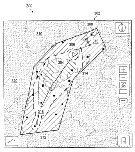
With reference now to Figure 3, an illustration of an envelope
displayed in an aeronautical chart in a graphical user interface is depicted
in
accordance with an illustrative embodiment. In this illustrative example,
graphical
user interface 300 is an example of an implementation for graphical user
interface
130 displayed in display system 108 in Figure 1. Aeronautical chart 302 is
displayed in graphical user interface 300. In this illustrative example,
aeronautical
chart 302 is a moving map.
As depicted, route 304 for an aircraft is displayed on aeronautical chart
302. Icon 306 is displayed on aeronautical chart 302 in a location
corresponding to
a location of the aircraft.
Envelope 308 is displayed in aeronautical chart 302. In this two-
dimensional display, undesirable space 310 is an area outside of envelope 308
and
is obscured in this illustrative example. In this illustrative example,
envelope 308 is
17
CA 02797907 2012-12-05
displayed using first color 312 and second color 314. First color 312
identifies
neutral space 316 in envelope 308.
Neutral space 316 in envelope 308 is an area in which a number of
objectives can be met. Second color 314 identifies desirable space 318 in
envelope
308. Desirable space 318 identified by second color 314 is an area in which a
number of objectives can be met or exceeded by the aircraft flying through
desirable
space 318. In this illustrative example, desirable space 318 is an area in
which
tailwinds are present. When the aircraft flies through desirable space 318 in
envelope 308, the aircraft may reach a target airport more quickly and may be
able
to fly with greater fuel efficiency.
In this illustrative example, undesirable space 310 is displayed using
third color 320. In this illustrative example, third color 320 may be selected
to
obscure information in undesirable space 310 on aeronautical chart 302. In
other
words, undesirable space 310 may be blacked out or obscured from the view of
the
operator. Of course, an operator may change the color or remove the color to
see
information in undesirable space 310, depending on the particular
implementation.
With reference now to Figure 4, another illustration of an envelope
displayed in an aeronautical chart in a graphical user interface is depicted
in
accordance with an illustrative embodiment. In this example, desirable space
318 is
no longer displayed within envelope 308. In this example, only neutral space
316 is
present. This change in the display of envelope 308 may occur in response to a
change in information. For example, when desirable space 318 in Figure 3
represents a presence of tailwinds, if tailwinds change or are no longer
present
during the operation of the aircraft, desirable space 318 is no longer
displayed within
envelope 308.
Turning now to Figure 5, yet another illustration of an envelope
displayed in an aeronautical chart in a graphical user interface is depicted
in
accordance with an illustrative embodiment. In this illustrative example,
information
for the aircraft has changed during the flight of the aircraft.
18
CA 02797907 2012-12-05
In this particular example, the change in information results in a
change in the shape of envelope 308. Further, desirable space 318 also has
changed in shape and location as compared to the illustration of envelope 308
in
Figures 3 and 4.
In this manner, changes in information that affect the flight of the
aircraft result in changes in the display of envelope 308. Further, the
illustration of
envelope 308 in Figures 3-5 is not meant to imply physical or architectural
limitations to the manner in which an illustrative embodiment may be
implemented.
In these illustrative examples, envelope 308 is displayed as a flight
envelope. In
other words, envelope 308 illustrates flyable space for an aircraft based on
route
304 in a flight plan for the aircraft. In other illustrative examples,
envelope 308 may
be displayed as a range envelope. In this example, envelope 308 may be
displayed
to indicate areas flyable by the aircraft without regard to a particular route
or flight
plan.
With reference now to Figure 6, an illustration of a block diagram of
flight information identifier 104 is depicted in accordance with an
illustrative
embodiment. As depicted, flight information identifier 104 comprises
information
retrieval system 600, situation system 602, and situation display 604.
In these illustrative examples, systems 112 in aircraft 102 in Figure 1
comprise automatic dependent surveillance broadcast (ADS-B) system 610,
weather
information system 612, and electronic centralized aircraft monitor (ECAM)
614. Of
course, systems 112 may include other systems in addition to or in place of
the ones
illustrated in this particular example.
As depicted, inertial measurement system 606 may generate
information, such as position, speed, altitude, and other information for
aircraft state
114 in Figure 1 in information 110. Flight management system 608 may provide
flight plan 117, a cost index, and other suitable information for aircraft
state 114 for
aircraft 102. Automatic dependent surveillance broadcast system 610 may
provide
19
CA 02797907 2012-12-05
information, such as aircraft traffic, traffic intent, predicted aircraft
traffic, and other
suitable information.
Weather information system 612 may provide current weather
information as well as predicted or forecasted weather information. Electronic
centralized aircraft monitor 614 may provide information, such as, for
example,
current fuel use, predicted fuel use, and other information.
Information retrieval system 600 is configured to obtain information
110 from systems 112 in these depicted examples. Information retrieval system
600
is configured to retrieve and process information 110. In these illustrative
examples,
information 110 received from systems 112 may be time-tagged. In other words,
information 110 may include timestamps.
Information retrieval system 600
correlates the information based on the timestamps.
Further, when predicted information is unavailable, information
retrieval system 600 also may provide predictions for various types of
information.
For example, if electronic centralized aircraft monitor 614 does not provide
an
estimated fuel use, information retrieval system 600 may predict fuel use
based on
past information about current fuel use.
Further, information retrieval system 600 places information 110 in a
format useable by situation system 602. For example, information retrieval
system
600 may use a format with five fields. These fields may be system, time,
variable,
and projected error. The system identifies a system in systems 112 from which
the
information in information 110 was received. Time represents the time at which
the
information in information 110 was received from the system identified. The
variable
identifies the parameter. The value is the value of the parameter. Projected
error is
the estimated error for the value.
For example, information received from inertial measurement system
606 may be as follows: INS, 17:00:00, ALT, 7500m, and 20m. In this example,
INS
represents inertial measurement system 606. 17:00:00 is the timestamp for the
information. ALT represents altitude. 7500m is the altitude identified, and
20m is
CA 02797907 2012-12-05
the projected error for the value. Of course, other numbers and types of
fields may
be used, depending on the particular implementation.
Situation system 602 is configured to identify envelope 118 based on
number of objectives 122 selected for aircraft 102 in Figure 1. In particular,
situation system 602 may represent the space around aircraft 102 as four-
dimensional space 618. Four-dimensional space 618 is a data structure that
identifies space 120 in Figure 1 in which aircraft 102 may fly at different
points in
time. In these illustrative examples, four-dimensional space 618 may be the
shape
of a cube. In this example, four-dimensional space 618 may take the form of a
four-
dimensional cube.
In these illustrative examples, four-dimensional space 618 may be
divided into cubes 620. Each cube in cubes 620 may be marked in a manner that
defines envelope 118. For example, each cube in cubes 620 may be marked to
indicate type of space 622. Type of space 622 may be, for example, selected
from
one of neutral space 624, desirable space 626, undesirable space 628, or as
some
other suitable type of space. Type of space 622 for cubes 620 may be marked
based on whether an objective in number of objectives 122 can be met by
aircraft
102 flying within a particular cube in cubes 620.
Type of space 622 for cubes 620 also may be marked based on
whether an objective in number of objectives 122 can be exceeded by some
threshold. Cubes 620 that meet the objective but do not exceed the objective
by
some threshold are marked as neutral space. Cubes 620 that exceed the number
of
objectives by the threshold are marked as desirable space.
If any objective cannot be met in number of objectives 122, the cube
may then be marked as undesirable. The use of neutral space, desirable space,
and undesirable space may be suited for when flight information identifier 104
is
used in aircraft 102 by operator 132 in Figure 1. In this manner, clutter or
too much
information may be avoided in displaying envelope 118 to operator 132.
21
CA 02797907 2012-12-05
Of course, a higher granularity may be present for cubes 620,
depending on the particular implementation. For example, particular types of
objectives that are met or exceeded by a threshold may be identified for
different
points in time. This increased amount of information may be suitable for when
flight
information identifier 104 is used on platform 134 in Figure 1. Situation
display 604
is configured to generate graphical user interface 130 with envelope 118
displayed
in aeronautical chart 128 in Figure 1. Aeronautical chart 128 may be displayed
in
two-dimensions or three-dimensions.
With reference now to Figure 7, an illustration of cubes in a four-
dimensional space is depicted in accordance with an illustrative embodiment.
In this
illustrative example, cubes 700 are shown as a pictorial illustration of cubes
620 for
four-dimensional space 618 in Figure 6.
In this illustrative example, axis 702 represents altitude, axis 704
represents latitude, and axis 706 represents longitude. Each of cubes 700
contains
an indication of whether the space in a particular cube is a neutral space, a
desirable space, or an undesirable space. In these illustrative examples, the
indication is made for different points in time. For example, cube 708 may
include
an indication that this space is a neutral space at one point in time but is
an
undesirable space in another point in time. As a result, the state of the cube
may
change over time.
Of course, in other illustrative examples, each cube may include more-
detailed information for different points in time. For example, cube 708 may
identify
levels of traffic for different points in time in addition to whether the
space is neutral,
desirable, or undesirable.
With reference now to Figure 8, an illustration of a flowchart of a
process for displaying information for an aircraft is depicted in accordance
with an
illustrative embodiment. The process illustrated in Figure 8 may be used in
aircraft
information environment 100 in Figure 1. In particular, the process may be
22
CA 02797907 2012-12-05
implemented in flight information identifier 104 in Figure 1. This process may
be
implemented in hardware, software, or a combination of the two.
The process begins by identifying information for an aircraft (operation
800). The process then identifies an aeronautical chart based on a location of
the
aircraft (operation 802).
The process then identifies an envelope that defines a space flyable by
the aircraft that meets a number of objectives (operation 804). In operation
804, the
envelope may be identified using a four-dimensional cube. In one illustrative
example, the plurality of cubes may be marked with an indication of a type of
space
based on the information identified for the aircraft.
The aeronautical chart is displayed on a graphical user interface in a
display system (operation 806). The envelope is displayed in the aeronautical
chart
(operation 808), with the process then returning to operation 800. In
operation 808,
the envelope may be displayed using the four-dimensional cube with the type of
space marked for the plurality of cubes in the four-dimensional cube. Further,
the
envelope may be displayed by obscuring or blacking out the areas of the
aeronautical chart that are outside of the envelope. In this manner,
information
areas in which the aircraft should not operate are not shown for consideration
by the
operator. Of course, the operator may opt to see the information if desired.
By
returning to operation 800, the process may identify changes to information
for the
aircraft and update the envelope as needed.
This process may be implemented in an aircraft during operation of the
aircraft. Further, the process also may be used by an operator at a platform
that is
remote to the aircraft while the aircraft is flying. In still other
illustrative examples,
the process may be used for planning purposes prior to the flight of the
aircraft.
Although information may change during actual flight, performing "what-if"
scenarios
during a planning process may be useful for selecting types of aircraft for
use or for
selecting routes and other items.
23
CA 02797907 2012-12-05
Turning now to Figure 9, an illustration of a flowchart of a process for
processing information for an aircraft to identify an envelope is depicted in
accordance with an illustrative embodiment. This process may be implemented in
flight information identifier 104 in Figure 1 and, in particular, in situation
system 602
in flight information identifier 104 in Figure 6.
The process begins by identifying cubes for a four-dimensional space
(operation 900). The four-dimensional space may be selected in a number of
different ways. For example, the four-dimensional space may be a space around
a
route for a flight plan of an aircraft. In another illustrative example, the
four-
dimensional space may be a selected distance from the current location of the
aircraft. The cubes in the four-dimensional space may have different sizes,
depending on the particular implementation.
The process selects an unprocessed cube from the cubes in the four-
dimensional space (operation 902). Each cube may have a plurality of entries
in
which each entry corresponds to a different point in time. A determination is
made
as to whether a route of an aircraft from a flight plan intersects the
selected cube
(operation 904).
If the route intersects the selected cube, an entry in the cube that
corresponds to the time that the aircraft intersects the selected cube is
identified
(operation 906). The process then marks the entry to indicate whether the
space in
the selected cube is neutral, desirable, or undesirable for that point in time
(operation 908).
With reference again to operation 904, if the route does not intersect
the selected cube, an identification of the minimum amount of time needed to
intersect the cube when deviating from the route is made (operation 910). The
entry
for that point in time is identified for the selected cube (operation 912).
The process
then proceeds to operation 908 as described above.
Thereafter, a determination is made as to whether additional
unprocessed cubes are present in the four-dimensional space (operation 914).
If
24
CA 02797907 2012-12-05
additional unprocessed cubes are present, the process returns to operation
902.
Otherwise, the process terminates.
Turning now to Figure 10, an illustration of a data processing system
is depicted in accordance with an illustrative embodiment. Data processing
system
1000 may be used to implement one or more computers in computer system 106 in
aircraft information environment 100 in Figure 1. In this illustrative
example, data
processing system 1000 includes communications framework 1002, which provides
communications between processor unit 1004, memory 1006, persistent storage
1008, communications unit 1010, input/output (I/O) unit 1012, and display
1014. In
this example, communications framework 1002 may take the form of a bus system.
Processor unit 1004 serves to execute instructions for software that
may be loaded into memory 1006. Processor unit 1004 may be a number of
processors, a multi-processor core, or some other type of processor, depending
on
the particular implementation.
Memory 1006 and persistent storage 1008 are examples of storage
devices 1016. A storage device is any piece of hardware that is capable of
storing
information, such as, for example, without limitation, data, program code in
functional form, and/or other suitable information either on a temporary basis
and/or
a permanent basis. Storage devices 1016 may also be referred to as computer
readable storage devices in these illustrative examples. Memory 1006, in these
examples, may be, for example, a random access memory or any other suitable
volatile or non-volatile storage device. Persistent storage 1008 may take
various
forms, depending on the particular implementation.
For example, persistent storage 1008 may contain one or more
components or devices. For example, persistent storage 1008 may be a hard
drive,
a flash memory, a rewritable optical disk, a rewritable magnetic tape, or some
combination of the above. The media used by persistent storage 1008 also may
be
removable. For example, a removable hard drive may be used for persistent
storage 1008.
CA 02797907 2012-12-05
Communications unit 1010, in these illustrative examples, provides for
communications with other data processing systems or devices. In these
illustrative
examples, communications unit 1010 is a network interface card.
Input/output unit 1012 allows for input and output of data with other
devices that may be connected to data processing system 1000. For example,
input/output unit 1012 may provide a connection for user input through a
keyboard, a
mouse, and/or some other suitable input device. Further, input/output unit
1012 may
send output to a printer. Display 1014 provides a mechanism to display
information
to a user.
Instructions for the operating system, applications, and/or programs
may be located in storage devices 1016, which are in communication with
processor
unit 1004 through communications framework 1002. The processes of the
different
embodiments may be performed by processor unit 1004 using computer-
implemented instructions, which may be located in a memory, such as memory
1006.
These instructions are referred to as program code, computer usable
program code, or computer readable program code that may be read and executed
by a processor in processor unit 1004. The program code in the different
embodiments may be embodied on different physical or computer readable storage
media, such as memory 1006 or persistent storage 1008.
Program code 1018 is located in a functional form on computer
readable media 1020 that is selectively removable and may be loaded onto or
transferred to data processing system 1000 for execution by processor unit
1004.
Program code 1018 and computer readable media 1020 form computer program
product 1022 in these illustrative examples. In one example, computer readable
media 1020 may be computer readable storage media 1024 or computer readable
signal media 1026.
26
CA 02797907 2012-12-05
In these illustrative examples, computer readable storage media 1024
is a physical or tangible storage device used to store program code 1018
rather than
a medium that propagates or transmits program code 1018.
Alternatively, program code 1018 may be transferred to data
processing system 1000 using computer readable signal media 1026. Computer
readable signal media 1026 may be, for example, a propagated data signal
containing program code 1018. For example, computer readable signal media 1026
may be an electromagnetic signal, an optical signal, and/or any other suitable
type
of signal. These signals may be transmitted over communications links, such as
wireless communications links, optical fiber cable, coaxial cable, a wire,
and/or any
other suitable type of communications link.
The different components illustrated for data processing system 1000
are not meant to provide architectural limitations to the manner in which
different
embodiments may be implemented. The different illustrative embodiments may be
implemented in a data processing system including components in addition to
and/or
in place of those illustrated for data processing system 1000. Other
components
shown in Figure 10 can be varied from the illustrative examples shown. The
different embodiments may be implemented using any hardware device or system
capable of running program code 1018.
Thus, one or more of the different illustrative embodiments provide a
method and apparatus for displaying information for operating an aircraft. In
particular, one or more illustrative embodiments may display an envelope on an
aeronautical chart on a display system. The envelope identifies a space in
which
the aircraft may fly that meets a number of objectives.
These objectives may include risk objectives, performance objectives,
optimization objectives, and other suitable types of objectives. With the use
of one
or more illustrative embodiments, the display of the envelope may reduce the
need
for an operator of an aircraft to consult numerous different sources of
information to
operate the aircraft. For example, an operator may avoid looking at paper
charts, an
27
CA 02797907 2012-12-05
electronic flight bag, and other sources to determine where the aircraft may
fly to
meet an objective.
Further, with one or more illustrative embodiments, clutter from too
much information being displayed also may be avoided. The use of the envelope
may allow an operator to quickly identify the space in which an aircraft may
fly. This
may be in contrast to the display of weather reports, aircraft state
information, or
other information on an aeronautical chart on a navigation display. As a
result, an
operator does not need to find and analyze information to determine where an
aircraft may fly.
The description of the different illustrative embodiments has been
presented for purposes of illustration and description and is not intended to
be
exhaustive or limited to the embodiments in the form disclosed. Many
modifications
and variations will be apparent to those of ordinary skill in the art.
Further, different
illustrative embodiments may provide different features as compared to other
illustrative embodiments. The embodiment or embodiments selected are chosen
and described in order to best explain the principles of the embodiments, the
practical application, and to enable others of ordinary skill in the art to
understand
the disclosure for various embodiments with various modifications as are
suited to
the particular use contemplated.
28