Note: Descriptions are shown in the official language in which they were submitted.
CA 02811172 2013-03-26
PRECISION GPS DRIVEN UTILITY ASSET MANAGEMENT
AND UTILITY DAMAGE PREVENTION SYSTEM AND METHOD
TECHNICAL FIELD
This application relates to a system and method for the development and
operational
use of precise utility location information and utility asset management
information.
BACKGROUND
There are many assets above ground and below ground that need to be protected
and
avoided. Included in these assets are utility lines and components and
protected areas, such
as archeological sites and habitat of endangered species. There are millions
of miles of utility
lines around the world, some buried and some above ground. These utility lines
include,
without limitation, electric power lines, telephone lines, water lines, sewer
lines, fiber-optic
cable lines, natural gas transmission lines, natural gas distribution lines,
and utility lines for
transporting hazardous liquids.
Every year incidents occur in which mobile ground breaking equipment comes in
contact with utility lines with costly results in loss of life and/or loss of
money. Statistics
kept by the United States Office of Pipeline Safety regarding pipelines
indicate that between
1986 and 2001 there were 1286 incidents involving natural gas transmission
lines, which
killed 58 people, injured 217 people and caused 284 billion dollars in
property damage. In
that same period there were 2159 incidents involving natural gas distribution
lines, which
killed 282 people, injured 1264 people and caused 256 billion dollars in
property damage.
There were also 3034 incidents involving utility lines carrying hazardous
liquids which killed
36 people, injured 244 people and caused a further 731 billion dollars in
property damage. In
order to understand the full impact of such incidents, one would have to also
include
environmental damage and economic loss as a result of a service disruption.
There have been many attempts to address damage prevention when groundbreaking
equipment is used around utilities and other assets that need protection. Non-
exhaustive
examples of these attempts include marking the location of a utility by
painted lines.
Commonly in the past, the utility companies and/or service companies are
called to the site to
place marks (spray the ground with an identifying color; for example, red for
electric lines,
yellow for gas lines and so forth) on the surface to show the location of a
specific utility line
and/or its components. Such marking is not permanent and typically lasts only
for the one
earth moving operation, such as digging a trench, for which the utilities were
marked.
Another approach was to make a record of the location of the utility lines as
the line
was placed in the earth. However, the accuracy of the location is dictated by
the accuracy of
the reference point. It has been found that attempting to locate a utility
line based op this
record has resulted in an error of up to 15 feet or more because of the
inaccuracy in the
1
CA 02811172 2013-03-26
position of the reference point.
Another approach is to use the record of the location of a facility, with its
inherent error
from inaccurate reference points, as the record to compare to the location of
a piece of ground
breaking equipment. This approach is disclosed in U.S. Patent 6282477 issued
on August 28,
2001 to Adam J. Gudat, et al. As noted in the Gudat et al patent at Col. 5,
lines 39-50, there is a
region of uncertainty that is a function of at least one parameter, including,
but not limited to,
inherent errors in the position determining system and errors in the
determined location of the
object (utility).
The determined location of the utility may be acquired by underground imaging,
which
is commonly accomplished by the use of ground penetrating radar. Examples of
underground
imaging are set forth in U.S. Patent No. 6,766,253 issued July 20, 2004; U.S.
Patent No.
6,735,888 issued May 18, 2004; U.S. Patent No. 6,700,526 issued March 2, 2004;
and U.S.
Patent No. 6,388, 629 issued May 14, 2004.
A common way of referencing the generated data identifying location of the
utility is to
use a fixed object, such as the curbing of a road. An example of the use of
ground penetrating
radar to acquire location data for underground utilities is described in U.S.
Patent 6,751,553.
SUMMARY
In accordance with one aspect of the invention, there is provided a utility
management
method. The method involves defining a utility project, defining parameters
for generating a
geographical database associated with the utility project, defining parameters
for collecting
utility information associated with the utility project, defining parameters
for integrating the
utility information and the geographical database, and defining a utilization
method for the
integrated utility information and geographical database.
The method may involve defining accuracy of the integrated utility information
and
geographical database.
The method may involve defining accuracy of the utilization method.
The utilization method may involve utility damage avoidance.
The method may involve during a life cycle of the project, certifying at least
one of
accuracy, completeness, currency and field usability of at least one of the
integrated utility
information and geographical database and the utilization method.
2
CA 02811172 2013-03-26
The method may involve synchronizing at least one of the geographical
database, the
utility information and the integrated utility information and geographical
database.
Synchronizing may involve maintaining at least one centralized database for
collecting
and/or utilizing data in the field.
The method may involve providing subscription-based access to the at least one
centralized database.
The invention relates to management of utility assets. For convenience, an
embodiment of a system constructed or a method practiced according to the
invention may be
referred to herein simply as an "embodiment."
Some embodiments generate or produce highly accurate information products and
applications for field use for Utility Asset Management or Utility Damage
Prevention. Some
embodiments produce an information product, called a Precision Integration
(PI) Grid that is
comprised of (above or below ground) utility location data combined with a GIS
Landbase that
includes satellite and/or other imagery and mapping information. In some
embodiments the PI
Grid advantageously provides the utility location data accurate to within 10
centimeters,
without using real-time kinetics (RTK), and within millimeter accuracy using
RTK. Some
embodiments also provide for the accurate recall of the information based on
the generation of
data using precision GPS technologies that provide absolute, as opposed to
relative, position
data. Here, precision GPS refers to a GPS system that may provide position
information with
accuracy as set forth herein for PI. Utility location information may be
recalled anywhere,
anytime in the world with the above mentioned accuracy.
Utility data may be accurately located and captured or collected by a data
logging
application using precision GPS technologies. The resultant data, as a PI
Grid, may be used in a
damage prevention (damage avoidance) application by a Damage Prevention Module
which
warns users of the proximity of above or below ground utilities in order to
avoid damage due to
conflict.
Some embodiments are comprised of component technologies, processes and
methods
that generate Information Products and provide for the productive use in the
field and certify its
accuracy and applicability for use on Projects that require Utility Asset
Management or Damage
Prevention tasks. Some embodiments provide data, tools and processes of
sufficient accuracy
3
CA 02811172 2013-03-26
and field operations utility that a Utility Damage Project Manager may rely on
them to avoid
damage to utilities due to ground breaking activities or for other Utility
Asset Management
tasks.
Some embodiments may be used for all phases of underground utility management,
from initial planning and engineering, through construction and life-cycle
maintenance.
Some embodiments substantially reduce the need for redundant field
measurements caused by
questionable or lost markers; and through improved information displays, there
may be a
significant reduction in the risks associated with construction activities
close to existing utilities.
Precision and Usability of Information Products
Some embodiments produce Information Products and Field Applications that meet
the
highest standards of accuracy and usability in the field. Some embodiments
develop information
products and field applications that may be used for Utility Damage
Prevention, a task that may
require the highest level of accuracy, reliability and currency of
information. Some
embodiments provide data and field applications that warn a ground breaking
project of the
location of above or below ground utilities. Striking or breaking a Utility
can be of such
consequence that tools and methods associated with this task must be of the
highest reliability.
Some embodiments generate enhanced utility location data sets that meet usage
criteria
that are set by project managers responsible for utility asset management
and/or damage
prevention on a project.
In some embodiments an important component of the development of location data
with
the aforementioned accuracy and recall is Precision Integration (PI). In some
embodiments PI is
a methodology and process and technology used to assure that data points at
each step of the
information product development are captured using precision GPS and
integrated into the
information product in a manner that produces data of the accuracy previously
described.
In some embodiments Precision Integration (PI) involves the use of an X,Y
coordinate,
and sometimes also a Z coordinate (e.g., altitude or depth), signal having a
horizontal (X,Y
coordinate) accuracy within 10 Centimeters (within 4 inches) without RTK and
millimeter
accuracy with RTK and vertical (Z coordinate) accuracy within 15 centimeters
without RTK.
This accuracy may be provided in collecting utility location data and in
creating a GIS database,
called a PI Landbase, that are combined in various steps of the system to
provide a PI Grid. In
some embodiments PI also involves the use of the accurate signal in creating a
movable map
4
CA 02811172 2013-03-26
that is displayed to show the accurate position of the data logger or other
data collection or data
usage device and the user in relation to the PI Landbase. The accurate signal
that is used
provides consistent accuracy throughout its life cycle of use (e.g., a life
cycle of a project).
In some embodiments a project manager may set forth and document accuracy,
completeness, currency and utility type visibility criteria and requirements
for the data sets to be
used for the specific project. For example, a project may require a SUE
engineering A Standard
for locating underground utilities. A data set may thus be created that meets
the criteria set by
the project manager. The completed data set may be designated a PI Grid when
it meets the
project usage criteria set by the project manager.
PI Grid Criteria for Field Use in Damage Prevention
In some embodiments a PI Grid is used by project managers for Utility Asset
Management and Utility Damage Prevention. Data integrity requirements differ
from project to
project. The PI Grid may be designed to support the highest level data
integrity requirement,
that is, damage prevention. By supporting the highest level of data integrity
requirement, value
added services may be provided for the remainder of Utility Asset Management
projects that
have lesser standards for data integrity. In most damage prevention scenarios,
there is a
requirement to use ground breaking equipment in areas where conflict with
utilities is probable.
In some embodiments, for utility location data to be useable for damage
prevention in the field,
the data meets the criteria that follow.
Precision Recall (Recall). Utility information is accurately recallable. PI
Grid location
source data is created using precision GPS, providing absolute rather than
relative positioning
and location of points. Data that is recalled, even years after it is
collected is precisely correct in
its location. A project manager that utilizes PI Grid data may be assured that
a utility is 'where
the map says it is', years after the data was collected. This capability may
vastly improve the
locating, planning, engineering, construction, maintenance and management of
underground
assets.
Utility Information is Precise and Accurate (Precise). Utility location
information may
be within ten centimeters without RTK and within millimeters when using RTK.
Precision location may be defined as being within ten centimeters without RTK
and within
millimeters when using RTK. A precision GPS system that may provide the
accurate coordinate
reference signal is manufactured by NavCom Technologies, Inc. This system is
the StarFireTM
5
CA 02811172 2013-03-26
Differential Global Positioning System. Absolute, anytime, anywhere is a
feature of StarFireTM
DGPS.
Field-actionable data. Information provided may meet standards of accuracy,
currency,
completeness, accessibility and usability that allow for its operational use
in utility location and
damage prevention in the field. The Data Logger and the Damage Prevention
Module may
utilize RTI and may provide real time Visual location in the context of a
project area map
enhanced with photo imagery of the project area. During utility data gathering
the data collector
can see where he is on the map, and verify the locations that he is taking
against identifiable
landmarks (e.g., as seen and as represented on the display). During damage
prevention usage
real time visual location and utility 'closeness' warning feedback may be
provided to an
individual or to equipment on which the module is placed. Thus, some
embodiments may
provide a level of visibility and human interaction that has not been provided
in conventional
systems.
Real Time Imagery (RTI). Utility information may be viewable in reference to
imagery
of the related or project area, in real time providing the current position of
equipment or
personnel relative to the location of utilities and may be viewable as the
person or machine
moves in any direction.
The PI Grid and Real Time Imagery (RTI)
In some embodiments a data set is developed which, after meeting project
criteria, is
designated or certified as a PI Grid. The PI Grid designation or Certification
may be significant
in that it may indicate to the project manager that the PI Grid meets project
criteria for the use
of the data in damage prevention or other utility asset management
applications. The PI Grid
may be presented to the user, via a computer screen, or a display as a
sophisticated, intuitive, project area map that provides utility location
information
superimposed on imagery of the project area (e.g., a visual representation of
an overhead view
and other indicia). The PI Grid may be presented as a movable map that
directionally turns with
the movement of the person or equipment to which the computer is attached or
carried. For
example, as the computer is moved (changes position) or turns (changes
direction) the displayed
image may change accordingly (e.g., keeping the computer in the middle of the
project area and
orientating the project area so that it "faces" the same direction as the
person or equipment).
This presentation method and technology may be referred to herein as Real Time
Imagery
6
CA 02811172 2013-03-26
(RTI). As a user walks or rides around a project area the PI Grid, presented
in RTI, may move
and indicate the location of the user (e.g., via a visual representation)
within the project area,
while simultaneously showing the location of utilities (e.g., via a visual
representation) within
user defined utility location buffer areas. The capability of presenting PI
Grid data in this
useable, real time mode provides project managers with real time utility
location data that is
accurate and actionable per the operational requirements of the project
manager.
Real Time Imagery (RTI) and Data Integrity
Some embodiments utilize RTI in several steps of the data development process
culminating in the certification of the PI Grid. The use of RTI in data
development may provide
a significant advantage as compared to traditional GIS/GPS data development
and collection
methods that are, in effect, 'blind' in their ability to validate data in the
field. In some
embodiments the Data Logger (DL) utilizes RTI as a major component of its data
collection
application. RTI may be used to present the project area including aerial
imagery for location
'sanity checks' and show the location of the user as he or she moves around
the project area. RTI
may show, in real-time, data points that are collected and Symbology and other
meta-data
attributes that may be associated with collected data. RTI may provide
realtime feedback, and
validation, and by facilitating 'eyes on the ground validation' may
significantly increase data
accuracy. Using RTI, data collectors may validate 'where they are' in a
project area and validate
that the data they are collecting is the 'correct data' .
The use of RTI may be particularly advantageous for damage prevention. The
Damage
Prevention Module (DPM) may utilize RTI to provide real-time utility location
data to operators
of ground penetrating equipment to avoid damaging utilities. The DPM may
provide
sophisticated targeting and 'lock on' capabilities that utilize user defined
buffers to warn
equipment operators of utilities that could be damaged by ground breaking
activities.
BRIEF DESCRIPTION OF THE DRAWINGS
These and other features, aspects and advantages of the present invention will
be more
fully understood when considered with respect to the following detailed
description, appended
claims and accompanying drawings, wherein:
FIG. 1 is a chart listing one embodiment of major components of a system
constructed
in accordance with the invention;
6a
CA 02811172 2013-03-26
FIG. 2 is a simplified block diagram illustrating one embodiment of a top
level life cycle
process flow of information and services, in accordance with the invention;
FIG. 3 is a simplified flow chart setting forth one embodiment of logical
steps
performed by NTR software module functionality in support of Damage
Prevention, in
accordance with the invention;
FIG. 4 is a simplified flow chart illustrating one embodiment of components
and logical
flow of functionality of the field application of the Data Logger Field, in
accordance with the
invention;
FIG. 5 is a simplified flow chart illustrating one embodiment of components
and logical
flow of functionality of the field application of the UI Imaging
functionality, in accordance with
the invention;
FIG. 6 is a simplified flow chart illustrating one embodiment of components
and logical
flow of the field application of the Damage Prevention module, in accordance
with the
invention;
FIG. 7 is a simplified flow chart illustrating one embodiment of components
and logical
flow of functionality of the field application of the Transponder Logger, in
accordance with the
invention;
6b
CA 02811172 2013-03-26
FIG. 8 is a simplified flow diagram illustrating one embodiment of data
management
and data synchronization of EMDS information prdduct flow, in accordance with
the
invention;
FIG. 9 is a simplified flow diagram illustrating one embodiment of a
relationship
between the Certification Process and major life cycle steps, in accordance
with the
invention;
FIG. 10 is a simplified flow diagram illustrating one embodiment of top level
development and information usage flow for Information Products, in accordance
with the
invention;
FIG. 11 is a simplified flow diagram illustrating one embodiment of data
collection,
in accordance with the invention;
FIG. 12 is a simplified schematic block diagram of one embodiment of data
manipulation, in accordance with the invention;
FIG. 13 is a simplified schematic block diagram of one embodiment of data
usage, in
accordance with the invention;
FIG. 14 is a simplified flow diagram of one embodiment of NIR, in accordance
with
the invention;
FIG. 15 is a simplified perspective view of one embodiment of system
components
used in a method of dynamically tracking a location of one or more selected
utilities as a
movement occurs within a municipal service area, in accordance with the
invention;
FIG. 16 is a simplified first detailed front elevation view of one embodiment
of a
display configured in accordance with the invention; and
FIG. 17 is a simplified second detailed front elevation view of one embodiment
of a
display configured in accordance with the teachings of the invention.
In accordance with common practice the various features illustrated in the
drawings
may not be drawn to scale. Accordingly, the dimensions of the various features
may be
arbitrarily expanded or reduced for clarity. In addition, some of the drawings
may be
simplified for clarity. Thus, the drawings may not depict all of the
components of a given
apparatus or method. Finally, like reference numerals denote like features
throughout the
specification and figures.
DETAILED DESCRIPTION
The invention is described below, with reference to detailed illustrative
embodiments.
It will be apparent that the invention may be embodied in a wide variety of
forms, some of
which may be quite different from those of the disclosed embodiments.
Consequently, the
specific structural and functional details disclosed herein are merely
representative and do not
limit the scope of the invention. For example, references to specific
structures and processes
in the disclosed embodiments should be understood to be but one example of
structures and
processes that may be used in these or other embodiments in accordance with
the teachings
7
CA 02811172 2013-03-26
provided herein. Accordingly, otherwise restrictive nomenclatures such as
"is," "are," etc.
should be understood to include less restrictive meaitings such as "may be,"
etc. In addition,
a reference to an element by an indefinite article such as "a" does not
exclude the possibility
that more than one of the element is present, unless the context clearly
requires that there be
one and only one of the elements.
In some embodiments a system constructed or method practiced according to the
invention may generate or produce highly accurate information products and
applications for
field use for Utility Asset Management or Utility Damage Prevention. Various
aspects and
features of such an embodiment will now be described in the conjunction with a
system that
incorporates six major components and a method that involves systems
integration of the
components to deliver the desired products and services. The six major
components
described in conjunction with the embodiment of Figure 1 and include 1)PI SW
Components;
2) GIS/GPS and Other Technologies; 3) Field Applications; 4) Data Services ¨
Electronic
Management and Distribution System; 5) Processes; and 6) Information Products.
1 - PI SW Components and 2 - GIS/GPS Technologies are integrated to develop or
provide 3 - Field Applications that are utilized under Process Control with as
set forth by 5 -
Processes. The system, utilizing Field Applications under Process Control
generates or
produces 6- Information Products that are utilized at different life cycle
steps by Field =
Applications to enhance data integrity or provide, in various forms, and on a
subscription
basis Information Products. Information Products are managed and distributed
during their
lifecycle by an Electronic Management and Distribution System.
Information Development and Services Life Cycle
In some embodiments the aforementioned components are combined into an
information product and services life cycle. The life cycle is controlled by
aforementioned
processes to ensure and guarantee the accuracy, currency, reliability and
field usability of
,data and field applications. The life cycle and processes may be modified to
fit the unique
requirements of each Project. In this way a wide range of service levels may
be supported.
Figure 2 illustrates an overview of one embodiment of an Information Product
Development life cycle. In particular, Figure 2 illustrates an example of top
level information
and services flow.
A ¨ Create Landbase. A Data Logger (A-1) is utilized to define and collect
initial
precise (utilizing PI) data points. External (non PI) data (A-2) including,
for example, maps
and electronic files may be collected per Project requirements (B-1). PI
(Precision
Integration) (A-3) is utilized to create a PI Landbase (A-5) utilizing, for
example, external
data (A-2) with a (A-4) GIS as described by Grid Certification criteria (B-1).
Imagery, maps
and other GIS Landbase data may be fitted to Precision Data Points creating a
Precision
Integration (PI) Landbase (A-5).
A PI Landbase may be created in a first step by first going to the project
area and
8
CA 02811172 2013-03-26
collecting initial coordinate data using a data logger referenced to the
accurate GPS signal.
Precise data points may then be collected in a second step.'
B ¨ Collect Data. Data is collected utilizing (B-2) Data Logger, (B-3) Ul
equipment,
(B-4) Transponder input or other input devices. External (non PI) data (B-4)
also may be
collected. Data collection scheduling and field methods may be defined by (B-
1) Grid
Certification criteria. Data collected creates a PI Facilities file (B-6) that
is merged with PI
Landbase (A-5) to create a (B7) PI Grid.
C ¨ Utilize Data. (C-1) Field Application for Damage Prevention (C-1) may
utilize
(B-7) PI Grid to provide Damage Prevention services and/or Asset Management
services (C-
2). Data Services (C-3) may provide access to PI Grid (B-7), PI Facilities
File (B-6) and
other information products.
Major Components
A more detailed description of the six major components follows.
1) PI SW Components ¨In some embodiment these components are software modules
that
provide key functionality as follows:
a) Precision Integration (PI) ¨ PI indicates that the component or process
supports or
has been developed utilizing PI software or processes. PI software may provide
a real
time interface to Precision GPS Hardware and Software providing:
i) Locate Data Functionality The ability to acquire the position of a
utility from
Precision GPS Hardware and Software and to capture the precision location
information and to integrate this information into a Precision GIS format in
real
time for immediate use and 'playback' utilizing RTI (real time imaging).
ii) Locate Position Functionality ¨ The ability to acquire (in real time) the
position of
Field GPS Hardware (e.g., located on a construction vehicle or being carried
by an
individual) and to utilize this real time location data for real time display
(e.g.,
using RTI) of the current location of the individual or equipment relative to
features and utility locations on a PI map. Location functionality also may be
used to determine distances and other critical information between the user
and
the utility for the purpose of damage prevention activities in the field. PI
may be
utilized at numerous steps and, in particular, during the collection of data
and
during the field operations of the Field Applications where real time
precision
location data is needed for Field Application functionality. PI may assure
that
data that is collected and utilized is accurate and recallable based on its
continuous
interface with the Precision GPS cycle during the product and services life
cycle.
b) RTI ¨ Real Time Imagery - RTI may present a project area defined by a PI
Landbase or PI Grid as a scrolling map including aerial imagery. RTI may be
used to
9
CA 02811172 2013-03-26
allow for location 'sanity checks' and display the location of the user or
construction
equipment as there is movement around a project area. RTI may shows (in real-
time)
data points that are collected, Symbology, meta-data and other relevant
application
information. RTI may thus facilitate real-time feedback and validation, and by
facilitating 'eyes on the ground validation' increases data accuracy
significantly.
Using RTI, data collectors are able to validate 'where they are' in a project
area and to
validate that the data they are collecting is the 'correct data'. RTI may
utilize PI as a
primary input and UGE as primary output.
c) UGE ¨ Universal Graphics Engine - A graphics engine for rendering and
displaying
PI Grid data in a standard GIS view format. UGE may be a Scaleable Vector
Graphics (SVG) application providing advanced Web based rendering of mapping
and other GIS data and may be useable with open architecture viewing products
and
may provide high flexibility for graphics support of portable devices like
PDAs and
other portable computing platforms.
d) SYM¨API ¨ Symbology API ¨ SYM-API is an Applications Programming Interface
(API) that allows Field Applications to utilize custom, previously developed
and/or
commercially or privately available vertical market Symbology libraries for
attaching
Symbols to data points that are collected. For example, such a symbol may
define a
particular physical feature of a utility. SYM-API is defmed and called by the
Field
Applications Administration module, as needed, based on the types of data that
are
being collected during the field session.
e) NTR ¨ Nearest Target Record (NTR) ¨ In some embodiments the NTR is a
software application that provides real-time location of utilities versus the
location of
the user or field equipment, selects the nearest utility or NTR, and provides
an
algorithm for presenting and warning of the location of this and other
utilities based
on user defined buffer rules.
Figure 3 illustrates an overview of one embodiment of NTR functionality.
This functionality includes process steps that the NTR software executes to
provide
Damage Prevention functionality to the DPM Damage Prevention Field
Application.
These operations are discussed in more detail below.
f) Transponder¨ Transponder with Asset Data. One approach for creating a
permanent record of precise location of assets, such as utility lines
underground, is to =
place transponders on the utility line as it is being placed in the ground.
Thereafter,
when the location of the utility line is to be recorded, dtransponder-on-line
reader is
moved along the ground to locate the transponders that are on the utility
line. As the
transponders are read, the position of the transponders, and therefore the
utility line, is
recorded by the use of an asset position recorder and a precision GPS receiver
coupled
to the recorder. Examples of placing transponders on utility lines and the
later
reading of the transponder to produce a record of the location of the
transponders and
CA 02811172 2013-03-26
thus the utility line are disclosed in U.S. Patent No. 6,778,128. The above-
described
apparatus and method for producing precision asset location data involve the
(1) recording
of the location during construction while the asset is being placed
underground or (2)
recording the output of transducers that have been placed on the asset, such
as the utility
line.
2) GIS/GPS Technologies - Other products and technologies may be integrated
into the system
or method to provide key functionality.
a) Precision GPS ¨ Today, precision GPS provides location results
with a standard of
accuracy that supports location of utilities within ten centimeters without
RTK and within
millimeters when using RTK. Precision GPS is used to deliver three-
dimensional fixes
and absolute, consistent location resolutions within 10 centimeters or better -
anytime, to
virtually every region of the planet's surface. Examples of precision GPS
receivers that
may be used are manufactured and sold by NavCom Inc. of Torrance, CA. A
particularly
useful receiver manufactured and sold by NavCom is the Starfire 2050G receiver
b) Underground Imaging (UI) - UI utilizes Ground Penetrating Radar (GPR),
Electromagnetic Imaging (EMI), CART (Computer Aided Radar Tomography) or other
technologies to locate underground utilities. A UI position reader and
recorder may be
integrated with a precision GPS receiver. The Reader and recorder includes an
antenna
array for transmitting radar and/or sonar signals into the ground and
recording the return
signals for locating any assets, such as utility lines, that are underground.
This apparatus
and method may provide a measurement and record of the depth of the utility as
well as
the longitudinal and latitudinal coordinates of the location of the utility.
Further, the
reader and the recorder may determine and record characteristics associated
with the
utility such as, for example, the size and material of the pipe or conduit of
the utility, such
as gas pipes, communication lines, water lines and so forth. PI also may be
used to
integrate the UI data into PI Grids for further field application use.
c) GIS Landbase - Some embodiments utilize, as a starting point, a
traditional GIS
Landbase consisting of located imagery, infrastructure, such as road, fences,
waterways,
and other features and other data. One example of a Landbase is provided by
Sentinel
USA of Newark, Ohio and is known by the trademark Precision LandBASE.
Application
of PI to a GIS LandBase converts the LandBase into a PI Landbase. A PI
LandBase is a
11
CA 02811172 2013-03-26
GIS LandBase template that is accurate enough to integrate and display
precision utility
location points to appropriate levels of accuracy for points taken with
Precision GPS.
Thus process may involve, for example, remapping landmarks or other features
from the
GIS LandBase with more precise PI location information.
d) Ruggedized Computer - Ruggedized Portable Computer. The host computer for
Field Applications including the Data Logger and Damage Prevention Module and
Transponder may be a computer modified to include storage media, an input
modem for a
GPS location device and administrative modules. One example of a lightweight,
powerful
and rugged computer is the Hammerhead XRT computer, which is available from
WalkAbout Computers, Inc. of West Palm Beach, Florida.
3) Field Applications - Software applications that provide key functionality.
These applications
maybe created through systems integration of (1) SW Components and (2) GIS/GPS
Technologies. (Fig 1)
a) Data Logger (DL) A Field Data collection application that
integrates, for example,
precision GPS, PI, RTI, and UGE with other utility data collection software
for the
purpose of the collection of Precision data points and utility location data
in the field. In
some embodiments a Data Logger is an asset position recorder that may be used
during
construction to record the position of an asset, such as a utility line as it
is being placed
underground. One example of a data logger is disclosed in U.S. Patent
Application
Publication No. U.S. 2004/0220731 on May 17, 2005. The data logger of the
referenced
published application may be converted to a PI data logger by employing the
precision
GPS signal and by using the PI Landbase.
Data Logger Functionality
Figure 4 illustrates one embodiment of a Data Logger apparatus for recording
global positioning system coordinates of components of a utility, which
includes a
portable controller having a memory and a global positioning system (GPS)
coordinate
device coupled to the controller.
Examples of inputs to the Data Logger are shown in Section (1) of Figure 4.
These inputs are (1-A) Precision GPS Receiver Input, (1-B) PI Landbase, and (C-
I) User
Input. Section 2 shows an example movable map and graphical and other user
interface
and that may be implemented by the integration of (1 -A) Precision GPS signal
with (2-
12
CA 02811172 2013-03-26
A) PI, precision integration (location) with (2B) RTI that is rendered as a
user interface
utilizing (2-C) UGE. Section 3 demonstrates example data logger functionality.
(1-C)
User Input provides input to (3-A) Admin module that sets up
Field Application parameters including (3 -B) SYM-API. (3 -C) Precision
Integration,
Data locate is used in conjunction with (1-A) Precision GPS signal and (3-C)
SYM- API
to create new utility location database (3-E) a PI Facilities File. (3E)
Facilities
File and (TB) PI Landbase are presented as movable map using (2B) RTI for real
time data
collection feedback and verification and are combined to create (3-F) a PI
Grid that is the
combination of the (1-B) original PI Landbase and the newly (3-E) created
12a
CA 02811172 2013-03-26
Facilities File.
b) Underground Imaging (UI) Data Recorder - A radar/sonar asset position
reader
and recorder coupled to and controlled by a precision GPS receiver and
integrated
with Data Logger functionality. The UI Data Recorder combines UI technology
with
Data Logger functionality resulting in the creation of PI Information Products
and =
functionality that includes data generated by UI technologies and methods
UI Data Recorder Functionality
Figure 5 illustrates one embodiment of Underground Imaging (UI)
Functionality. Examples of inputs.to the UI Data Recorder are shown in Section
(1)
of Figure 5. These inputs are (1-A) Precision GPS Receiver Input, (1-B) PI
Landbase,
and (C-1) User Input. Section 2 shows an example movable map and graphical and
other user interface that may be implemented by the integration of (1-A)
Precision
GPS signal with (2-A) UI Hardware and Software with PI, precision integration
(location) with (2B) RTI that is rendered as a user interface utilizing (2-C)
UGE.
Section 3 demonstrates UI example Data Collection functionality. (1-C) User
Input
provides input to (3-A) Admin module that sets up Field Application parameters
including (3-B) SYM-API. (3-C) Precision Integration, Data locate is used in
conjunction with (1-A) Precision GPS signal and (2-A) UI Data location inputs
and
(3-C) SYM-API to create new utility location database (3-E), a PI Facilities
File. (3E)
Facilities File and (1B) PI Landbase may be combined to create (3-F) a PI
Grid.
c) Damage Prevention Module (DPM) ¨ The Damage Prevention application provides
field useable utility location and warning capabilities to avoid damage to
utilities. In
some embodiments the Damage Prevention module utilizes the PI Grid output from
the Data Logger, UI Data Collection or the Transponder Recorder applications
as the
basis for providing Damage Prevention functionality in the field. The Damage
Prevention application may be used to warn of critical distances between
identified
utilities and digging equipment and displays visual and audible alarms. A user
may
input to the administration module parameters such as the length and reach of
the
digging equipment and the scale for the warning display. Numerous other
parameters
may be input to the administration module by the user at the project site. The
application may prevent the accidental hitting or damage to assets, such as
gas
pipelines, by the digging equipment by a filtration process which is set forth
by the
NTR software module.
Damage Prevention (DPM) Functionality
Figure 6 illustrate one embodiment of Damage Prevention Functionality.
Examples of inputs to the Damage Prevention Application (DPM) are shown in
Section (1) of Figure 6. These inputs are (1-A) Precision GPS Receiver Input,
(1-B)
PI Grid, and (C-1) User Input. Section 2 shows example movable map and
graphical
and other user interface that may be implemented by the integration of (1-A)
= 13
CA 02811172 2013-03-26
_
Precision GPS signal with (2-A) PI, precision integration (location) with (2B)
RTI
and (3-F) PI GRID and (3-C) Display Warning that is rendered as a user
interface
utilizing (2-C) UGE. Section 3 demonstrates example damage prevention
functionality. (1-C) User Input provides input to (3-A) Admin module that sets
up
Field Application parameters and (3-B) NTR damage prevention setup parameters.
(3-
E) Precision Integration, Data locate is used in conjunction with (1-A)
Precision GPS
signal and (3-B) NTR and (3-F) PI Grid to implement warning system as a visual
display via (2B) RTI and as an audible warning (3-C).
d) Transponder Logger ¨ Transponder Data Logging Field Application. Data
Logger capability may be integrated with a transponder-on-line reader that is
moved
along the ground to locate the transponders that are on the utility line. As
the
transponders are read, the position of the transponders, and therefore the
utility line, is
recorded. Transponders may be located via signals that they transmit, and may,
also
include original precision GPS location data that was collected as they were
placed on
the utilities.
Transponder Recorder Functionality
Figure 7 illustrates one embodiment of Transponder Logger Functionality.
Examples of inputs to the Transponder Recorder are shown in Section (1) of
Figure 7.
These inputs are (1-A) Precision GPS Receiver Input, (1-B) PI Landbase, and (C-
1)
User Input. Section 2 shows example movable map and graphical and other user
interface that may be implemented by the integration of (1-A) Precision GPS
signal
with (2B) RTI that is rendered as a user interface utilizing (2-C) UGE.
Section 3
demonstrates example Transponder Recorder functionality. (1-C) User Input
provides
input to (3-A) Admin module that sets up Field Application parameters
including (3-
B) SYM-API. (3-C) Precision Integration, Data locate is used in conjunction
with (2-
A) Transponder location and data signal and (3-C) SYM-API to create new
utility
location database (3-E), a PI Facilities File. (3E) Facilities File and (1B)
PI Landbase
are presented as movable map using (2B) RTI for real time data collection
feedback
and verification and are combined to create (3-F) a PI Grid.
4) PI Data Services - Electronic Management and Distribution System (EMDS) ¨
Some
embodiments utilize an Electronic Management and Distribution system to
manage, store,
and distribute information products that are generated. EMDS may provide
configuration
management and data synchronization services to field applications and may
provide
subscription based private and public access to information products that are
developed.
EMDS may be utilized as a key component to the implementation of configuration
management and security considerations that are set forth by Project Criteria
as described
in the Certification processes that are used to guarantee or certify data to
be used on
various projects.
Figure 8 illustrates one embodiment of EMDS Data Processing and Field
14
CA 02811172 2013-03-26
Synchronization Flow. Figure 8 illustrates the data management and processing
flow of
EDMS in support of Project data management piocess criteria. The Project may
be
defined based on criteria set by the Project Manager and all system parameters
for the
Project are programmed into the EMDS system. The Initial PI Landbase is stored
on the
system for distribution to field application computers. SYNC programs download
the
initial PI Landbase to Data collector applications. Data Collector
Applications are further
configured in the field then perform data collection tasks. Data collected is
SYNC back
to EDMS and processed (if necessary) to create a PI Grid. PI Grid data is SYNC
back to
the field for Damage Prevention Applications. PI Landbase and PI Grid data is
provided
by EDMS for public or private use on a subscription basis.
The EMDS may serve as a central repository for Information Products that are
developed. Data is moved securely from the central repository to the field via
the Internet
utilizing secure and robust applications like Web Services that are currently
provided by
the Microsoft .Net architecture. Field application's access EMDS via the
Internet via
wireless transfer methods. All information products are served to users via a
Web
graphics user interface provided by the Universal Graphics Engine (UGE) which
supports
graphical displays on a wide variety of viewing devices including portable
computers,
PDAs and cell phones.
5) Processes ¨ Processes may be invoked or other wise incorporated to certify
or guarantee
the accuracy and usefulness of Information Products. In some embodiments
Processes
and Certification Methods (Certification) are used to validate and certify
that utility
location data meets accuracy, completeness and usability standards. A Project
Manager
that is depending on PI based Damage Prevention Services may seek assurance
that the PI
Grid data is accurate, complete, up to date and applicable to the Project to a
standard that
provides a high degree of confidence that utility damages will be avoided if
the system is
utilized to identify the location of potential utility conflicts,
Certification may answer
the following questions for the Project Manager and give the Project Manager a
confidence level at which he or she can utilize the data to take actions in
the field:
a) Is the Project Area correctly defined? Do I have all the data I need to
support the
Project?
b) Is utility positional data correct? To what degree (distance from actual
utility
location) is it correct?
c) How current is the Data? Have any utilities or other construction been put
in the
ground since the utility locations were collected?
d) Who developed the data and when?
e) How complete is the data? Was data collected and verified in conjunction
with
planned Project utility activities (pot holing, as- built) at the project
site?
f) Have significant or dangerous utilities (gas lines) been specifically
called out?
g) Have personnel on the site (equipment operators, supervisors, data
collectors)
CA 02811172 2013-03-26
been trained and certified in the use of the equipment?
Figure 9 illustrates one embodiment of Certification and Management Processes.
Figure 9 illustrates that a Certification Process may provide a management and
operational
framework to support a Project. At each step of the process of creating
information products
or utilizing field applications, Project Criteria are followed to ensure the
integrity and
applicability and usability of the data in support of the particular
requirements of each
project. In some embodiments Process and Certification may involve the
following steps:
1) Define Project ¨ Set Project Criteria and Data Collection Plan
a) Define PROJECT SCOPE (SUE, FAA, Utility)
i) Regulatory environment - What rules, regulations, laws, constraints,
measures
apply to this Project
ii) Data Access and Usage, Who has access to What data, When
iii) Define PROJECT GRID - Area within which project will be performed
b) Define PI LANDBASE FEATURE SET
i) GIS Data, Projections Datum etc.
= ii) Images - Source, Currency, Resolution
Other Maps - Source, Configuration, Detail
iv) Other Data Sources - File Format
v) Define Error correction criteria for imported data (maps and other GLS
data)
c) Define UTILITY DATA GATHERING PROCESS
i) Roles and Responsibilities (Project Manager Field Mgmt, GPS Field Services,
Data Logging Company, UI Company)
ii) Define Types and Sequence of Data Gathering (PI Locates, PI Potholes, PI
As
Built, Pi UI
iii) Quantify Number of Data Gathering Sweeps - Number of iterations of each
type
of data gathering
d) Define PI GRID CRITERIA
i) Define Data UPDATE and Configuration Management BUSINESS RULES
ii) AGREE ON CRITERIA FOR ACCEPTANCE OF PI GRID (approved use of
data set for Damage Prevention
e) Define CERTIFICATION Training CRITERIA (training required for Data
Gathering
and Use of Damage Prevention)
2) Create PI Landbase
a) BUILD PROJECT PI LANDBASE
i) Identify Project Grid Area with PI Grid SYSTEM
ii) Field Gather Precision Grid Locate Points
=
16
CA 02811172 2013-03-26
iii) Acquire Imagery based on Project Criteria
iv) Acquire Maps and other Data Inputs base:d on Project Criteria =
v) Implement Precision placement (rubber sheeting etc.) of all input data
vi) RELEASE PI LANDBASE (Release to Project based on Project Criteria)
Vii) ACCEPT PI LANDBASE (Project Manager Reviews and Accepts Precision
Landbase)
3) Collect Utility Location Data
a) COLLECT UTILITY DATA - Certified FIELD UNITS
i) SET UP PROJECT on Field Application (Set up Field Unique Profiles (i.e.
TYPE
of Collection (Locates, As Built etc.) Symbology Set, User etc.)
ii) COLLECT DATA in Field Utilizing Data Logger Application
Validate Field Data Collection Utilizing Data Logger View Application
iv) SYNCH - (UPLOAD) Field Data to Data Services Server
16 b) REPEAT PROCESS AS REQUIRED BY PROJECT REQUIREMENTS
c) COLLECT UTILITY DATA - 3RD PARTY Ur DEVICES
i) SET UP PROJECT on Field Application (Set up Field Unique Profiles (i.e.
TYPE
of Collection (Locates, As Built etc.) Symbology Set, User etc.)
ii) COLLECT DATA in Field Utilizing 3RD PARTY DEVICE
iii) PROVIDE RAW DATA TO POST PROCESSING CONTRACTOR
iv) 3rd Party Data is Post Processed and ADDED TO PROJECT GRID ON Data
Services Server
v) SYNCH - (DOWNLOAD) FIELD DATA INCLUDING 3RD PARTY DATA to
Data Services Server
vi) REPEAT PROCESS AS REQUIRED BY PROJECT REQUIREMENTS
4) Utilize Data for Project Purposes (Damage Prevention, Asset
Management)
a) CERTIFY PI GRID ( Validate with Project Manager that Data may be used for
Damage Prevention)
i) Project Manager - REVIEWS, ACCEPTS AND CERTIFIES that Grid may be
used for Damage Prevention on Project
CERTIFY - (MARK) PROJECT GRID AS API GRID on Data Services
b) PROVIDE GUARDIAN PROSTAR DATA SERVICES
i) Damage Prevention Services
ii) Utility Asset Management Services
6) Information Products ¨ Information Products may be produced through the use
of Field
Applications and PI Processes. Information Products may be managed and
distributed
through their life cycle by Data Services supported by the EMDS platform. Data
17
CA 02811172 2013-03-26
products are developed during the life cycle of a Project. Customers will have
access to and
usage of information products based on parameters set for each Project.
Information Products
are created from informational 'building blocks' during the life cycle of a
Project. For example,
a PI Grid, which may be the most comprehensive Information Product, may be
built from a GIS
Landbase, that is improved into a PI Landbase to which utility location
information (in the form
of a PI Facilities File) is added to produce a PI Grid. In some embodiments
the PI Grid is the
only information product that may be certified for use for Damage Prevention
and must be
created utilizing Project processes and parameters that result in
Certification of the PI Grid for
this type of use.
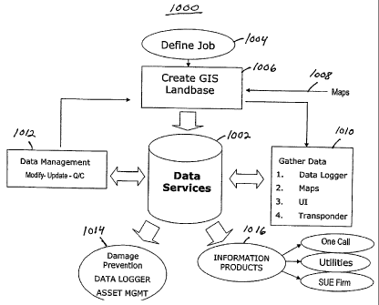
With the above operations in mind, Figure 10 illustrates an overview of one
embodiment
of a management system 1000 constructed in accordance with the invention.
These operations
may be performed in conjunction with various data services 1002 as discussed
herein. Initially,
a project (job) is defined a block 1004. Next, a GIS Landbase is created
(block 1006) utilizing
map data 1008. Data is gathered (block 1010) using, for example, one or more
data logger, map,
UI and transponder devices. Data management operations (block 1012) may be
invoked to
manage one or more of the databases. A precision database may then be used for
damage
prevention, data logging and asset management operations (block 1014). For
example, asset
management operations may include using a facility file or similar information
to identify,
characterize or track an asset. In addition, various information products
(block 1016) may be
defined as discussed herein.
Referring now to Figures 11 - 14, one embodiment of a damage prevention system
will
be discussed. The damage prevention system consists of three parts; two of
which may be
housed in the same housing. The three parts are apparatus and method for
collecting data,
apparatus and method for manipulating the data to put it into a standardized
form and the
apparatus and method for using the data on equipment to prevent damage by the
equipment or
to minimize damage to the equipment.
Precision [within 10 centimeters, without using real-time kinetics (RTK), and
within
millimeter accuracy using RTK] asset location data may be created by the
apparatus and method
of this invention, in particular, there is shown in Fig. A of Fig. 11 an
apparatus and method that
provides a precision location of the asset, such as a utility line, as it is
being placed in the earth.
A permanent record of this precision location is based on latitudinal and
longitudinal
18
CA 02811172 2013-03-26
coordinates that are stored for later use. A precision GPS receiver 10
provides the precise
latitudinal and longitudinal coordinates for the asset position recorder 11
while the utility line is
being placed in the ground. Precision GPS receivers that may be useful in this
invention are
manufactured and sold by NavCom Inc. of Torrance, CA. A particularly useful
receiver
manufactured and sold by NavCom is the Starfire 2050G receiver. An asset
position recorder II
that may be used during construction to record the position of an asset, such
as a utility line as it
is being placed underground, is disclosed in U.S. Patent Publication No. 2004-
022731 Al
published November 4, 2004.
Another approach for creating a permanent record of the precise location of
assets, such
as utility lines underground, is shown in Fig. B of Fig. 11. In this approach
transponders are
placed on the utility line as it is being placed in the ground. Thereafter,
when the location of the
utility line is to be recorded, a transponder-on-line reader 14 is moved along
the ground to
locate the transponders that are on the utility line. As the transponders are
read, the position of
the transponders, and therefore the utility line, is recorded by the use of an
asset position
recorder 15 and a precision GPS receiver 16 that is coupled to the recorder
15. The precision
GPS receiver 16 may be the same receiver as the GPS receiver 10 of Fig. A. The
output of the
asset position recorder 15 is an ASCII stream having fields for the
latitudinal coordinates, the
longitudinal coordinates and the identification of the underground asset. The
placing of
transponders on utility lines and the later reading of the transponder to
produce a record of the
location of the transponders and thus the utility line are disclosed in U.S.
Patent No. 6,778,128.
The two above-described apparatus and method for producing precision asset
location
data involve the recording of the location during construction while the asset
is being placed
underground or recording the output of transducers that have been placed on
the asset, such as
the utility line. Many areas do not have any information as to the location of
assets such as
utility lines that are underground in the area. An effective way of
determining the location of
such assets and permanently recording the location for later use is the
apparatus that is shown in
Fig. C of Fig. 11. This apparatus includes a radar/sonar asset position reader
and recorder 18
coupled to and controlled by a precision GPS receiver 19. This GPS receiver 19
may be the
same as the GPS receiver 10 of Fig. A. Reader and recorder 18 includes an
antenna array for
transmitting radar and sonar signals into the ground and recording the return
signals for locating
any assets, such as utility lines, that are underground. This apparatus and
method provides a
19
CA 02811172 2013-03-26
measurement and record of the depth of the utility as well as the longitudinal
and latitudinal
coordinates of the location of the utility. Further, the reader and the
recorder 18 determines and
records the size and material of the pipe or conduit of the utility, such as
gas pipes,
communication lines, water lines and so forth. The output of the reader and
recorder 18 is an
ASCII stream with fields for the longitudinal coordinate, latitudinal
coordinate and
identification of the asset or utility that is underground at the precise
location.
There are various devices for locating utilities and recording the location of
these
utilities such as radar/sonar readers and ground penetrating radar readers.
However, it has been
found that the records created by these readers may have the location of the
underground asset
or facility as much as 15 feet away from the actual location. Thus, if this
information is to be
used in a precision damage control system, it is necessary to determine
19a
CA 02811172 2013-03-26
the extent of error and correct for this error when the data is employed.
Apparatus for
employing the records of earlier readers and recorders 21 is shown in Fig. D
of Fig. 11. The
output of the reader and recorder 21 passes through an error detector which
develops an error
correction signal that is coupled to the data and is used in correcting the
location of the asset
when the data is employed in a damage control system. Further, there are some
existing asset
position records that have been created when the utility or asset has been
placed in the
ground. It has been found that these records also are not accurate in the
location of the asset.
Consequently, the difference between recorded location and actual location
must be
determined as shown in Fig. F. of Fig. 11. An error detector 24 is coupled to
the output of
existing asset position records medium 23 for developing an error correction
signal to be
coupled to the data for use by a damage control system.
Data Manipulation
The asset location data at the output of the apparatus of Fig. 11 is coupled
as the input
to a utility designating unit 40 shown in Fig. 12. The utility designating
unit 40 may be
located in the field and employed at the same time as the precision asset
location data is being
read and recorded by the various apparatuses 11, 14, and 18 shown in Figs. A,
B and C of
Fig. 11. The precision asset location data that is in the form of ASCII codes
in designated
fields has ASCII fields added in unit 40 to identify the type of utility
employing symbology
information from a library. A layer definition field is also added based on
the type of utility
that has been identified. For example, a gas pipeline is a very dangerous
utility to cut into in
the field while digging in the field. Consequently, gas lines are identified
at a higher level
than other utilities and have a greater buffer zone around the line to prevent
the accidental
hitting of the line in the field. The output of the utility designating unit
40 is coupled to a
converter 41 that converts the data stream into a geographical information
system (GIS)
format. There are several major or standard formats including, for example,
Autodesk, ESRI,
Intergraph, GE Small World, and MapInfo. The GIS format is selected on the
basis of the
subsequent use of the data by a damage control unit. In addition to the
information
concerning the asset or utility, it is often times desirable to have the
infrastructure, such as
road, fences, waterways, and so forth, that are in the area mapped on a
display that is being
used for displaying the location of the assets. A location of the
infrastructure in the GIS data
should be as precise as the location of the utilities from the precise asset
location data. Such
precise 015 data is provided by SentinelUSA of Newark, Ohio and is known by
the trademark
Precision LandBASE Data. The file of such data is contained in the memory 42
shown in Fig.
12.
The utility designating unit 40 may also have input from the readers and
recorders 21
and 23 of Figs. D and E of Fig. 11. In this case, the asset location data will
also include the
error compensation signal at the output of error detectors 22 and 24. This
error signal is used
by the utility designating unit 40 to provide an additional buffer or area
around the utility
based on the degree of error that is shown by the error correction signal.
CA 02811172 2013-03-26
Data Usage
There are two types of equipment that may uk the data that is provided by the
utility
designating unit 40 and converter 41 at a work area where the location of
assets, need to be
known to prevent damage to the asset and/or the equipment at the work area.
One type of
equipment is that used in breaking ground near above-ground assets and near
underground
assets. Another type of equipment that may use the data is emergency
equipment, such as fire
fighting equipment, where it is useful to know the location of the various
utilities, such as
power lines and gas lines. The use of the data will be described in connection
with digging
equipment at a site.
The asset location data in the form of a facility file at the output of the
converter 41 is
provided to a control unit 50 (Figure 3) that is positioned on the digging
equipment (not
shown) at the project site. The control unit or controller 50 may be a
computer modified to
include storage media, an input modem for a GPS location device and
administrative
modules. One acceptable lightweight, powerful and rugged computer is the
Hammerhead
' XRT computer, which is available from WalkAbout Computers, Inc. of West Palm
Beach,
Florida.
The facility file may be provided by a direct coupling between the converter
41 and
the controller 50 on the digging equipment. In this case the asset location
data is provided to
the utility designating unit 40 on the digging equipment by a memory device or
by an Internet
coupling or line coupling to a location where the asset location data is
stored. Alternatively to
the direct coupling, the facility file data may be provided on a memory medium
to the
controller 50 or may be transmitted to the controller 50 by way of the
internet, wireless
communication, or direct coupling by line to a facility where the facility
file is stored for the
particular project site. The controller 50 includes a facility file memory 51
and a GIS file
memory 52. The controller 50 further includes a microprocessor and memory 53
that includes
software for performing a unique filtration process that identifies the
utilities and/or protected
areas that are within the selected range of the equipment at the project site.
The equipment
(digger) is represented by an input modem 54 that provides the OPS location of
the
equipment at the project site. The OPS location of the equipment is determined
by a precision
GPS receiver 60 that provides its input to the controller 50 through the modem
or GPS
equipment location block 54.
An administration module 55 is provided in the controller 50 so that the user
of the
controller 50 may input control signals for the digger at the particular
project site. These
control signals include critical distances between identified utilities and
the digging
equipment for displaying alarms and for also causing audible alarms. The
administration
module 55 also requires a password to be entered for the user to log into the
controller 50 for
use at the project location. The user also inputs to the administration module
55 parameters
such as the size and reach of the digging equipment and the scale for the
display on the
display 61. Numerous other parameters may be input to the administration
module by the
21
CA 02811172 2013-03-26
user at the project site The apparatus at the project site also includes an
audible alarm 62
which may be internal of the controller 50 or external of the controller 50 as
shown in Fig.
13.
The microprocessor 53 of the controller 50 scans the data in the facility file
51 and
displays all utilities within a selected range of the digging equipment. The
selected range may
be 100 feet or 1000 feet, for example. The controller 50 prevents the
accidental hitting or
damage to assets, such as gas pipelines, by the digging equipment by a unique
filtration
process which is set forth as a flow chart in Fig. 14. In Step 1 the software
for filtration,
which is part of the microprocessor 53, retrieves stored positional
coordinates of assets and
incoming GPS positional coordinates of the digging equipment. In Step 2 the
filtration
process compares the positional coordinates; that is, performs a cross data
query in real time
between the positional coordinates of the assets and the incoming GPS
positional coordinates
of the digging equipment. Step 3 of the filtration process includes the
calculation of the
distance of the assets from the equipment by the positional coordinate
differences and
identifies those within selected zones. The selected zones may be 10 ft., 20
ft. or 30 ft. from
the digging equipment for example. In Step 4 of the process the software
retrieves and scans
the linear segments of each asset's data stream of the asset within the
selected zone to
produce target filtration records (TFR). In Step S of the process the software
separates the
target filtration record segments and orders them numerically by a calculated
target distance
value while continuously checking against the real time GPS positional
coordinates. In Step 6
of the process the software identifies the present nearest target record NTR)
and isolates this
record from the other TFRs. In step 7 of the process, the software locks onto
the linear record
of the present nearest target record and notes the distance of this asset from
the digging
equipment. In Step 8, the software displays the nearest target record asset's
position relative
to the position of the digging equipment on the display 61. While the nearest
target record
asset is being displayed on the display 61, the buffer distance for the
identified asset is used.
In Step 9 the process retrieves the positional coordinates and the buffer zone
of the asset that
has been identified as the nearest target record. In Step 10, the warning zone
for the particular
asset is retrieved and is an input as part of Step 11. In Step 11, the
distance of the asset that
has been identified with the nearest target record-, including the assets
buffer zone, from the
digging equipment is detennined and compared to warning zones. In Step 12 of
the process
warning signals and colors are generated. In Step 13 the warning signal and
color are coupled
to the display 61 and to the audible alarm 62. In one embodiment the asset on
the display is
displayed with a flashing yellow to indicate that the asset is within the
designated range for
caution. As the relative distance between the asset and digging equipment
decreases, the
display changes to orange to inform the user that it is in the warning zone.
As the distance
reaches a critical point of danger, the location of the asset is indicated in
a flashing red and
the audible alarm signal in step 14 is created and the alarm is sounded in the
audible alarm
62. For critical assets such as high pressure gas lines, when the relative
distance between the
22
CA 02811172 2013-03-26
asset and the digging equipment reaches the danger zone, and depending upon
the system
settings, the digging equipment can be automatically disabled so that no
further digging may
take place and there will be no damage to the asset and also to the equipment
and equipment
operator.
Referring now to Figures 15 - 17, a method of dynamically tracking a location
of one or
more selected utilities as a movement occurs within a municipal service area
will now be
described. This method is described in U.S. Patent No. 6,798,379.
In Figure 15, a first step involves: providing a portable controller,
generally indicated by
reference numeral 110. Controller 110 has a memory 112 and a global
positioning system
(GPS) co-ordinate device 114. A scrolling display 116 is also coupled to
controller 110.
A second step involves storing in memory 112 a series of GPS co-ordinates 118
for one
or more selected utilities 120 within an assigned service area of a
municipality as shown in
Figure 16.
Referring to Figure 15, a third step involves: using GPS co-ordinate device
114 to
dynamically provide GPS co-ordinates 118 to controller 110 as positioning of
GPS co-ordinate
device 114 changes location.
Referring to Figure 16, a fourth step involves: using scrolling display 116 to
display
GPS co-ordinates of GPS co-ordinate device 114 on a display 122 of global
positioning system
co-ordinates, together with a series of GPS co-ordinates 118 for one or more
of selected utilities
120, such that the relative position of GPS co-ordinate device 114 to one or
more selected
utilities 118 is always known.
Referring to Figure 16, scrolling display 116 has a graphic indicator 124
which indicates
a direction of travel for GPS co-ordinate device 114. There is also displayed
a numeric indicator
126 which indicates the distance in the direction of travel before GPS co-
ordinate device 114
encounters the closest of selected utilities 120. There is also a graphic
indicator 128 depicting a
target, which graphically indicates the positioning of satellites available to
GPS co-ordinate
device 114.
Referring to Figure 16, scrolling display 116 has a numeric indicator 130,
which
indicates longitude, and a numeric indicator 132, which indicates latitude
132. Display also has
a graphic indicator 134, which indicates speed of travel 134 of GPS co-
ordinate device 114. Of
course, when emergency crews are on foot the speed will be negligible.
However, when the
23
CA 02811172 2013-03-26
emergency crews are traveling in a vehicle, the speed of the vehicle will be
indicated.
Referring to Figure 16, scrolling display 116 places GPS co-ordinates 118 in
the context of a
geographical map 136 with road infrastructure 138. It is preferred that
geographical map 136
may be in the form of an aerial photo.
Referring to Figure 17, scrolling display 116 has a pop-up display screen 140
which
provides vital data identifying characteristics of the closest of selected
utilities 120. In the
23a
CA 02811172 2013-03-26
illustrated example, the utility identified is a natural gas pipeline owned by
Process Energy-
Eastern North Carolina Natural Gas, serviced out ea contact office in Raleigh,
N.C.
An important aspect is the dynamic nature of scrolling display 116, which
scrolls as
the GPS co-ordinates of GPS co-ordinate device 114 change. This scrolling
aspect is
particularly apparent when the emergency crew is approaching a site in a
vehicle. The
system continuously scans the GPS data it receives: first, to ascertain the
position of GPS- co-
ordinate device 114 and second, for relative co-ordinates of utility hazards.
All of the
displays continually scroll and update the data with movement of GPS co-
ordinate device
114. When one gets within a pre-determined area of interest, a circular icon
146 appears on
scrolling display 116 and locks onto the closest utility to show the point at
which GPS co-
ordinate device 114 will cross the utility if it continues in the same
direction.
Referring to Figure 16, scrolling display 116 may also be manually scrolled
using an
on screen up arrow 142 or an on screen down arrow 144, to enable the emergency
crew to
manually look ahead, without changing their position.
It should be appreciated that the various components and features described
herein
may be incorporated in a system independently of the other components and
features. For
example, a system incorporating the teachings herein may include various
combinations of
these components and features. Thus, not all of the components and features
described herein
may be employed in every such system.
Different embodiments of the invention may include a variety of hardware and
software processing components. In some embodiments of the invention, hardware
components such as controllers, state machines and/or logic are used in a
system constructed
in accordance with the invention. In some embodiments code such as software or
firmware
executing on one or more processing devices may be used to implement one or
more of the
described operations.
Such components may be implemented on one or more integrated circuits. For
example, in some embodiments several of these components may be combined
within a
single integrated circuit. In some embodiments some of the components may be
implemented as a single integrated circuit. In some embodiments some
components may be
implemented as several integrated circuits.
The components and functions described herein may be connected/coupled in many
different ways. The manner in which this is done may depend, in part, on
whether the
components are separated from the other components. In some embodiments some
of the
connections represented by the lead lines in the drawings may be in an
integrated circuit, on a
circuit board and/or over a backplane to other circuit boards. In some
embodiments some of
the connections represented by the lead lines in the drawings may comprise a
data network,
for example, a local network and/or a wide area network (e.g., the Internet).
The signals discussed herein may take several forms. For example, in some
embodiments a signal may be an electrical signal transmitted over a wire while
other signals
24
CA 02811172 2013-03-26
may consist of light pulses transmitted over an optical fiber. A signal may
comprise more than
one signal. For example, a signal may consist of a series of signals. Also, a
differential signal
comprises two complementary signals or some other combination of signals. In
addition, a
group of signals may be collectively referred to herein as a signal. Signals
as discussed herein
also may take the form of data. For example, in some embodiments an
application program may
send a signal to another application program. Such a signal may be stored in a
data memory.
A wide variety of devices may be used to implement the database and data
memories
discussed herein. For example, a database or data memory may comprise RAM,
ROM, disks,
flash memory or other types of data storage devices.
In summary, the invention described herein generally relates to an improved
utility
management system. While certain exemplary embodiments have been described
above in
detail and shown in the accompanying drawings, it is to be understood that
such embodiments
are merely illustrative of and not restrictive of the broad invention, in
particular, it should be
recognized that the teachings of the invention apply to a wide variety of
systems and processes.
It will thus be recognized that various modifications may be made to the
illustrated and other
embodiments of the invention described above, without departing from the broad
inventive
scope thereof. In view of the above it will be understood that the invention
is not limited to the
particular embodiments or arrangements disclosed, but is rather intended to
cover any changes,
adaptations or modifications which are within the scope defined by the
appended claims.
25