Note: Descriptions are shown in the official language in which they were submitted.
ak 02811444 2013-11-08
- 1 -
Geodetic Survey System having a Camera
Integrated in a Remote Control Unit
The invention relates to a survey system having a position
determination unit, in particular a total station or a GNSS
module, for determining a target position in a defined
coordinate system, and having a mobile target unit, equipped
with a survey stick, for definition and/or position
determination of target points in a defined coordinate
system, to a mobile target unit for a survey apparatus
according to the invention, to a remote control unit for a
mobile target unit according to the invention, and to a
method for defining and/or determining the position of a
target point with a survey system according to the invention.
In order to survey one, or in particular a plurality of
target points, numerous geodetic survey apparatuses have been
known since antiquity. As standard spatial data, distance and
direction, or angle, from a measuring apparatus to the target
point to be surveyed are in this case recorded and, in
particular, the absolute position of the measuring apparatus
is acquired together with possibly existing reference points.
Widely known examples of such geodetic survey apparatuses
consist of the theodolite, tachymeter or total station, which
is also referred to as an electronic tachymeter or computer
tachymeter. A geodetic survey instrument of the prior art is
described, for example, in the publication document EP 1 686
350. Such apparatuses have electrosensor angle and distance
measurement functions, which allow determination of direction
and distance to a selected target. The angle and distance
ak 02811444 2013-11-08
- 2 -
quantities are in this case determined in the internal
reference system of the apparatus and, for an absolute
position determination, may possibly also need to be
correlated with an external reference system.
In many geodetic applications, points are surveyed by placing
specially configured target objects at them. These usually
consist of a pole having a targetable marking or a reflector
for defining the measurement distance, or the measurement
point. Using a central geodetic survey apparatus, even a
relatively large number of target objects can therefore be
surveyed, although this requires that they be identified. In
such survey tasks, in order to control the measurement
process and establish or register measurement parameters,
various data, instructions, words and other information need
to be transmitted between the target object - in particular a
handholdable data acquisition apparatus at the target object
- and the central measuring apparatus. Examples of such data
are the identification of the target object, inclination of
the pole, height of the reflector above ground, reflector
constants or measurement values such as temperature or air
pressure.
Modern total stations have microprocessors for the digital
postprocessing and storage of acquired measurement data. The
apparatuses are generally produced in a compact and
integrated design, usually with coaxial distance and angle
measurement elements as well as calculation, control and
storage units integrated in an apparatus. Depending on the
development level of the total station, means for motorizing
the target optics, for reflectorless distance measurement,
ak 02811444 2013-11-08
- 3 -
for automatic target search and tracking and for remote
control of the entire apparatus are integrated. Total
stations known from the prior art furthermore have a radio
data interface for setting up a radio link to external
peripheral components, for example to a data acquisition
apparatus which, in particular, may be formed as a
handholdable data logger, remote control unit, array
processor, notebook, small computer or PDA. By means of the
data interface, measurement data acquired and stored by the
total station can be output to external postprocessing,
externally acquired measurement data can be read into the
total station for storage and/or postprocessing, remote
control signals for remote control of the total station or of
another external component, particularly in mobile field use,
can be input or output, and control software can be
transferred into the total station.
For sighting or targeting the target point to be surveyed,
geodetic survey apparatuses according to the generic type
comprise, for example, a target telescope, for example an
optical telescope, as a sighting device. The target telescope
can generally be rotated about a vertical axis and about a
horizontal tilt axis relative to a base of the measuring
apparatus, so that the telescope can be oriented towards the
point to be surveyed by swiveling and tilting. In addition to
the optical viewing channel, modern apparatuses may have a
camera integrated in the target telescope, and for example
oriented coaxially or parallel, for acquiring an image, in
which case the acquired image may in particular be
represented as a live image on the display of the
display/control unit and/or on a display of the peripheral
ak 02811444 2013-11-08
- 4 -
apparatus used for the remote control - for example of the
data logger or the remote control unit. The optics of the
sighting device may in this case have a manual focus - for
example an adjustment screw for changing the position of
focusing optics - or an autofocus, the focal position being
changed for example by servo motors. Automatic focusing
devices for target telescopes of geodetic apparatuses are
known, for example, from DE 197 107 22, DE 199 267 06 or DE
199 495 80.
The sighting of a target reflector may in this case be
carried out in particular by means of a live image, which is
displayed to the user in the display of the data logger or of
the remote control unit, which is provided by a camera - for
example arranged coaxially in the target telescope or with an
orientation parallel to the target telescope - as the
sighting device of the total station. Accordingly, the user
can orientate the total station with the aid of the live
image in accordance with the desired target identifiable in
the live image.
EP 1 734 336 discloses a survey system comprising a target
unit, which has a reflector and an optical receiver and
transmitter. It is in this case proposed to use the optical
transmitter of the target unit inter alia to assist the
automatic target search process. Thus, after reception of the
search or measurement radiation, the target object can
communicate its own identification, for example the reflector
number or the reflector type, back to the survey station with
the aid of the transmitter of the target unit. The survey
ak 02811444 2013-11-08
- 5 -
station can therefore identify the target object found and be
configured optimally with respect to the target object.
EP 1 573 271 discloses a target unit also having an optical
transmitter, wherein - after reception of measurement
radiation of a survey apparatus - the target unit sends back
an optical signal on which the target unit's own identity is
modulated.
A feature common to the aforementioned survey systems from
the prior art is that, optionally with the use of a camera,
the target unit or a survey stick provided with the target
unit is sighted or observed by a stationary position
determination unit, for example a total station. However, no
automated guidance of an operator by using the image data
recorded by the stationary position determination unit for an
intended target point for the purpose of defining the latter
is disclosed, so that the definition process is relatively
laborious for an operator and entails considerable time
expenditure when accurate definition of the target point is
intended to be ensured.
For a solution to this problem, US 7 222 021 and the
corresponding EP 1 293 755 propose a survey system, referred
to in this patent as an operator guiding system, having a
stationary base station corresponding to a stationary
position determination unit, which is equipped with imaging
means, for example a camera, and a mobile station with the
function of a mobile target unit, which is equipped with
display means, for example a display for representing a
current position of the user on the basis of stored landscape
images or data, and current images, as seen from the
ak 02811444 2013-11-08
- 6 -
stationary measurement unit. They also disclose the way in
which an operator can be guided to the target point by means
of correlation between the position data currently measured
from the stationary measurement station, including a camera
image, for the mobile station, and stored data comprising the
intended position of the target point, by marking on the
display of the target unit, for example by a direction
display by means of an arrow on the display.
Although the process of defining a target point can be
accelerated with this system described in US 7 222 021 and
the corresponding EP 1 293 755, the disclosure does not
reveal any possibilities of improving the accuracy of the
definition of the target point; this is because the mobile
station does not have its own image acquisition means, and
real images are acquired only by the distant stationary total
station, while merely synthetic calculated representations
from a bird's-eye perspective are used on a mobile display
for guiding the mobile station, for example a pole with a
reflector.
WO 2010/080950 essentially discloses a pole having a camera
fitted (according to the figures) on the upper end in order
to determine an azimuth for a target point. It is to be noted
that this positioning of the camera can restrict the
operability of the apparatus by a user shadowing the image.
Connection to a theodolite or a total station is mentioned,
but without disclosure regarding coordination/correlation of
image data. This document contains no mention of the use of
an effect of the fitted camera, or the data thereof, on
possible precise positioning of the pole on a target point.
ak 02811444 2013-11-08
- 7 -
It is an aspect of the present invention to provide a survey
system and associated units for the survey system, as well as
a corresponding surveying method, with which the process of
definition and/or position determination of target points can
be further accelerated, and further simplified for the
operator, and in particular the precision or accuracy of the
process can be improved. It is a further aspect of the
invention to provide a possibility of storing, and thus
documenting, the actual position of a defined target point in
correlation with stored and current data of a stationary
position determination unit at the time of definition.
The invention relates to a survey system having a position
determination unit, in particular a total station or a GNSS
module, for determining a target position in a defined
coordinate system, as well as a mobile target unit for
definition and/or position determination of target points in
the coordinate system. The target unit comprises a survey
stick, the lower end of which can be brought into target
point contact. A target, the target position of which can be
determined with high precision, can be fitted on the survey
stick. The target may, in particular, be formed as a survey
reflector which can be surveyed with the aid of a total
station, for example as a reflective prism, or as a GNSS
antenna having a data link to the GNSS module of the position
determination unit.
The position determination unit determines, for example, the
angles in the horizontal and vertical direction as well as
the distance to the target, for example a prism. For a survey
system according to the invention with an embodiment of the
CA 02811444 2013-11-08
- 8 -
position determination unit having a GNSS module, the mobile
target unit is for example equipped with a GNSS antenna on
the survey stick so that the current position of the target
can be determined from GNSS measurements.
As the position determination unit for a survey system
according to the invention, in principle all embodiments, in
particular total stations such as theodolites or GNSS modules
(GNSS = Global Navigation Satellite System, for example the
Global Positioning System known to the person skilled in the
art and abbreviated to GPS) may be envisioned, as are known
from the prior art for geodetic survey systems, when they
fulfill the requirements according to the present invention,
in particular for data-based communication with a mobile
target unit. For this reason, particular suitable embodiments
of the position determination unit will be discussed in more
detail below.
The mobile target unit furthermore comprises a handholdable
remote control unit for the survey system. The remote control
unit comprises an electronic graphical display and can be
attached to a holder on the survey stick in such a way that -
in the attached state - the remote control unit is in a fixed
position relationship with respect to the target fitted on
the survey stick.
According to the invention, the remote control unit comprises
a camera for recording a camera image in a defined imaging
direction. According to the invention, an image processing
and evaluation unit having a data link to the position
determination unit and the camera is furthermore provided, by
which - with the aid of knowledge of the fixed position
ak 02811444 2013-11-08
- 9 -
relationship and the defined imaging direction, and as a
function of the target position determined - image data of
the camera are brought into spatial relation with the target
points in the coordinate system.
The fixed position relationship of the remote control unit,
both with respect to the target fitted on the survey stick
and with respect to the lower end of the survey stick, must
be known or surveyed at least once and stored in the system
data, or it may be measured and logged in real time at the
time of surveying or definition for a target point for the
associated process, by an apparatus connected to the mobile
target unit or the attached remote control unit with the
associated camera.
As suitable measurement units for such position
determinations from the mobile target unit, or the remote
control unit, for example known systems based on laser,
ultrasound, radar or radiowave measurement in the known
frequency ranges are suitable, which may be connected to the
mobile target unit or integrated therein, or in the remote
control unit.
For position determination of the remote control unit, which
is associated with the mobile target unit, with respect to
the stationary position determination unit, stereophotometry
may also be employed by using a further camera, fitted either
on the stationary position determination unit for the purpose
of observation therefrom or on the mobile target unit.
In order to determine an inclination of the remote control
unit, or of the associated camera, with respect to the survey
CA 02811444 2013-11-08
- 10 -
stick, an inclination sensor or predetermined angle (for
example 45 or 90 ) may optionally be provided for mounting
in the orientation of the remote control unit, or of the
associated camera, with respect to the axis of the survey
stick. The (azimuthal) orientation of the remote control
unit, or of the associated camera, may for example be
determined by a compass, in particular an electronic compass,
which is for example integrated in the remote control unit,
the survey stick or the target. As an alternative, the survey
stick with the remote control unit fitted thereon and the
camera may be oriented in a known direction, for example
toward the position determination unit, the sun or known
positions sighted by the position determination unit.
In other words, with respect to the spatial orientation of
the mobile target unit (that is to say the pole with the
target fitted at the top and the remote control unit attached
in a fixed way - i.e. in a known position) in the defined
coordinate system, this may either be based on fixed
assumptions which are made, for example that the survey stick
is always kept vertical at the measurement position and the
remote control unit is always oriented azimuthally in the
direction of the total station, in the north direction or in
the direction of the sun, or sensors especially suitable
therefor may be provided (for example a biaxial inclination
sensor for determining the current inclination of the survey
stick and a compass for the azimuthal orientation of the
target unit).
It is preferred that the camera, the display, the position
determination unit and the image processing and evaluation
ak 02811444 2013-11-08
- 11 -
unit are formed and interact in such a way that, as a
function of the currently determined target position, one or
more target points to be defined or surveyed, which lie in
the field of view of the camera and the spatial coordinates
of which are known, can be displayed together with the camera
image in the display. Advantageously, markings for the target
points are in this case displayed in accordance with the
target point position, overlaid with the camera image on the
display.
It is advantageous in particular that a film sequence
acquired by the camera is displayed live on the display and -
overlaid on the displayed film sequence - as a function of
the currently determined target position, one or more target
points to be defined or surveyed, the spatial coordinates of
which are known, are marked in the camera image and displayed
on the display.
Advantageously, the camera and the display are arranged and
oriented on the remote control unit in such a way that the
surface normal of the display is oriented essentially
parallel to the imaging direction of the camera. Preferably,
the optical axes of the display and of the camera are in this
case oriented essentially coaxially - but the viewing
directions mutually opposite. In other words, this means that
an operator is offered the possibility of a direct view of
the position of a target point to be defined in the display
according to the displayed stored data and the associated
marking. - Such a "viewing mode" allows a very accurate match
of the marking actually carried out for a target point with
its intended placement, and at the same time storage and
ak 02811444 2013-11-08
- 12 -
exact documentation of the target placement at the current
time in correlation with the simultaneously recorded data of
the (stationary) position determination unit. - Such a
possible use is neither disclosed nor anticipated in the
known prior art.
Preferably, the camera is oriented in such a way that - when
the remote control unit is attached to the survey stick - the
lower end of the survey stick lies in the field of view of
the camera.
It is likewise preferred that, when the remote control unit
is attached to the survey stick - owing to the structure of
the survey stick - the fixed position relationship of the
remote control unit relative to the fitted target is ensured.
The fixed position relationship of the image processing and
evaluation unit of the remote control unit with respect to
the target may, in particular, be made available with the aid
of one of the following means:
= storage means, in which the fixed position relationship
is stored,
= position relationship determination means, which make a
current distance from the remote control unit to the target
and/or a current orientation, in particular the azimuthal
and/or elevational orientation, of the remote control unit
determinable, in particular with the position relationship
determination means comprising a distance sensor and/or a
compass integrated in the remote control unit and/or an
inclination sensor integrated in the remote control unit,
ak 02811444 2013-11-08
- 13 -
= input means, so that data relating to the fixed position
relationship can be entered by the user,
= a data set stored electronically or graphically on the
survey stick, in particular the holder, which comprises
information relating to the fixed position relationship
ensured by the survey stick, and readout means provided in
the remote control unit so that the data set can be read
out at the remote control unit.
The invention furthermore relates to a mobile target unit for
a survey system according to the invention, which comprises a
survey stick, the lower end of which can be brought into
target point contact. A target, the target position of which
can be determined with high precision, can be fitted on the
survey stick. The target may, in particular, be formed as a
survey reflector which can be surveyed with the aid of a
total station, or as a GNSS antenna having a data link to the
GNSS module of the position determination unit. The mobile
target unit furthermore comprises a handholdable remote
control unit for the survey system. The remote control unit
comprises an electronic graphical display and can be attached
to a holder on the survey stick in such a way that - in the
attached state - the remote control unit is in a fixed
position relationship with respect to the target fitted on
the survey stick.
According to the invention, the remote control unit comprises
a camera for recording a camera image in a defined imaging
direction. According to the invention, an image processing
ak 02811444 2013-11-08
- 14 -
and evaluation unit having a data link to the position
determination unit and the camera is furthermore provided, by
which - with the aid of knowledge of the fixed position
relationship and the defined imaging direction, and as a
function of the target position determined - image data of
the camera are brought into spatial relation with the target
points in the coordinate system.
Advantageously, the camera and the display are arranged and
oriented on the remote control unit in such a way as to allow
an operator a possibility of viewing a terrain surface by
means of the camera, with the surface normal of the display
being oriented essentially parallel to the imaging direction
of the camera, in particular with the optical axes of the
display and of the camera being oriented essentially
coaxially - but the viewing directions mutually opposite.
The invention furthermore relates to a remote control unit
for a mobile target unit according to the invention. The
remote control unit comprises an electronic graphical display
and can be attached to a holder on the survey stick in such a
way that - in the attached state - the remote control unit is
in a fixed position relationship with respect to the target
fitted on the survey stick. According to the invention, the
remote control unit comprises a camera for recording a camera
image in a defined imaging direction. In this case, an image
processing and evaluation unit having a data link to the
position determination unit and the camera is provided, by
which - with the aid of knowledge of the fixed position
relationship and the defined imaging direction, and as a
function of the target position determined - image data of
ak 02811444 2013-11-08
- 15 -
the camera are brought into spatial relation with the target
points in the coordinate system.
The invention furthermore relates to a method for defining
and/or determining a position of a target point with a survey
system according to the invention. The method comprises the
following steps:
= attaching a handholdable remote control unit, having a
camera fitted thereon, to a survey stick, the lower end of
which can be brought into target point contact, with the
remote control unit being attached in a fixed position
relationship with respect to a target fitted on the survey
stick,
= establishing or ensuring a data interchange link between
the mobile target unit, in particular the remote control
unit, and the position determination unit,
= arranging the camera in the direction of a terrain
surface, in which target points are to be defined or
surveyed, and recording images and displaying them on a
display of the remote control unit continuously or at
defined time intervals,
= inserting a direction indicator, in particular by means
of an arrow, and/or indicators of distance to an intended
target point and/or a marking for the intended position of
the intended target point, into the image of the cameras in
the display,
ak 02811444 2013-11-08
- 16 -
= guiding the target unit until a match of the image of
the lower end of the survey stick with the marking for the
intended position of the target point is achieved,
=
defining or determining the position of the target
point.
Optionally, recording in real time and storage of an image of
the defined or position-determined target point may
additionally be carried out by means of the camera.
Overall, the present invention very greatly simplifies or
facilitates the process of definition and/or position
determination of target points for an operator, which is
associated with a significant achievable process
acceleration. At the same time, the invention allows
significant improvement of the accuracy in the definition and
position determination of target points. The camera fitted on
the handholdable remote control unit, as a main feature of
the present invention for improving survey systems according
to the generic type, facilitates and improves the conduct of
the aforementioned processes by a current live image of the
lower end of the survey stick being overlaid in an image of
the remote control unit camera with a marking of the intended
or stored position of a target point. The video stream of
this camera shows a current view of the surface of the
terrain to be surveyed.
This is substantially different from the representation
possibilities of known systems according to the generic type,
in which surface views are typically simulated for a user
ak 02811444 2013-11-08
- 17 -
from current measurement data of a stationary position
determination unit, in conjunction with a mobile target unit,
and stored data, without - apart from the distance and
direction between the stationary position determination unit
and the mobile target unit - further data relating to the
mobile target unit being taken into account.
As described above, the camera fitted on the handholdable
remote control unit allows a ground "viewing mode" without -
in the case of a corresponding orientation of the camera -
the user himself being compelled to look constantly at the
ground (in particular directly below or in front of him),
which makes it easier for the operator to move forward in
terrain which is particularly difficult to navigate.
A corresponding configuration of the handholdable remote
control unit, or of the camera fitted thereon, for example
with sensors for determining the orientation of the camera,
according to the invention also makes it possible for the
operator to record overview photographs of a terrain to be
surveyed, from the position of the mobile target unit, the
information of which can be converted by correlation with the
stationary position determination unit into the coordinate
system thereof.
In particularly steep terrain, problems may sometimes arise
in that the position of a target point to be defined can no
longer be projected accurately into the current image of the
camera of the remote control unit. For this, corrections of
the position mark inserted for the target point to be defined
may be provided, by using and jointly taking into account a
DTM ("digital terrain model") of the terrain for the
ak 02811444 2013-11-08
- 18 -
corresponding insertion of the position mark. If a DTM of the
terrain is not available, then an RIM (Range Imaging Sensor)
camera may also be integrated in the remote control unit,
with the aid of which a terrain model can be acquired before
or even during the definition and the measurement process,
and therefore taken into account (or alternatively with the
aid of stereophotogrammetry).
The method according to the invention and the apparatuses
according to the invention will be described in more detail
below purely by way of example with the aid of specific
exemplary embodiments schematically represented in the
drawings, further advantages of the invention also being
discussed. In detail:
Figure 1 shows a survey system according to the prior art;
Figure 2 shows a survey system according to the present
invention;
Figure 3 shows a survey system according to Figure 2,
additionally with a direction indicator from a
lower end, imaged in a display, of a survey stick
to a marking for an intended target point;
Figure 4 shows another possible embodiment of a survey
system according to the invention;
Figure 5 shows another possible embodiment of a survey
system according to the invention;
ak 02811444 2013-11-08
- 19 -
Figure 6 shows the functionality of a survey system
according to the invention in field use with the
aid of the image in the display of a remote control
unit according to the invention;
Figure 7 shows a possible embodiment of a target unit
according to the invention;
Figure 8 shows another possible embodiment of a target unit
according to the invention;
Figure 9 shows a mobile target unit having a GNSS module,
all the components of the mobile target unit being
integrated in a handholdable apparatus;
Figure 10 shows a possible application of the mobile target
unit shown in Figure 9 in the field;
Figure 11 shows a plan view of the mobile target unit shown
in Figure 9; and
Figure 12 shows a plan view of another alternative embodiment
of the mobile target unit shown in Figures 9 and
11.
The following description of the figures is directed at the
use of the invention for the definition of target points.
Position determination of target points in the sense of the
present inventions is carried out in an entirely similar way
to this. All embodiments of the invention described above and
below may be combined with one another in any desired way, as
well as with the aforementioned prior art, unless explicitly
stated otherwise.
ak 02811444 2013-11-08
- 20 -
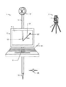
Figure 1 shows a survey system according to the prior art.
The survey system comprises a position determination unit 2
formed as a total station, and a mobile target unit 1 having
a survey stick 11 which has a lower end 13. A target, which
in this example is formed as a survey reflector 12' that can
be surveyed by the total station 2, is fitted on the survey
stick 11. A handholdable remote control unit 3, which is
preferably formed as a data logger, having a display 9 is
attached to a holder (not shown) of the survey stick. A
focused live image of a camera as a sighting device 7 of the
total station 2 can be displayed on the display 9. The camera
may be integrated in a target telescope as a sighting device
7 of the total station 2, with corresponding optics. Besides
the current view of an operator of the mobile target unit 1,
the intended position of a target point 20 in the landscape
is represented in the live image of the camera as a marking
20'. The operator changes his position in the landscape until
he establishes a match of his current position with the
marking 20' in the camera image, and then defines the target
point 20. - The survey system according to the invention may
also be operated according to this functionality, which comes
from the prior art, by selecting a corresponding screen
display option.
Figure 2 shows a survey system according to the present
invention. In contrast to the survey system according to
Figure 1, the handholdable remote control unit 3, in this
operating mode attached to the survey stick 11, is equipped
on its lower side with a camera 5 in a defined holding
direction, i.e. in this example the direction of the ground.
The remote control unit 3 is in a fixed position relationship
ak 02811444 2013-11-08
- 21 -
with respect to the survey reflector 12' attached to the
survey stick 11 and functioning as a target. The live stream
of the camera 5 is represented on the display 9 of the remote
control unit 3. In the upper middle of the image, the image
13' of the lower end 13 of the survey stick 11 can be seen in
a manner corresponding to the field of view of the camera 5.
Inserted into the camera image, there is a marking 20' which
displays the intended position of the target point 20 to be
defined. This corresponds to an exemplary situation in which
the intended position of the target point 20, corresponding
to the marking 20', lies in the field of view of the camera
5. Finding and definition of the target point 20 is thereby
substantially facilitated, and the definition process is
accelerated compared with the possibilities which are
provided by the prior art. Furthermore, the accuracy of the
target point definition can be increased significantly and
finally also documented exactly in a true fashion since the
monitoring of the match between the intended position of the
target point 20 and its actual definition is carried out not
by a far distant camera, but directly in situ by the camera 5
also carried by the mobile target unit 1, in the field of
view of which the lower end 13 of the survey stick, in this
example formed as a tip, is located.
The arrow 30 symbolizes a data link of the camera 5 to an
image processing and evaluation unit (not shown), as there is
also from there to the position determination unit 2. With
the aid of knowledge of the defined imaging direction of the
camera 5 and of the fixed position relationship between the
remote control unit 3, comprising the camera 5, and the
survey reflector 12' attached to the survey stick 11, and as
ak 02811444 2013-11-08
- 22 -
a function of the determined current target position 20' of
the survey reflector 12', the image data of the camera in a
defined coordinate system of the position determination unit
2 are brought into spatial relation with the one or more
target points 20.
Figure 3 corresponds essentially to the arrangement
represented in Figure 2. Additionally, an arrow 21 is
represented on the display 9, by which the direction and
distance to the intended position of the target point 20
according to the marking 20' is indicated to an operator. So
long as the intended position of a target point 20 lies
outside the field of view of the camera 5, for example, only
a direction arrow is displayed, preferably also with a
distance indication, but without an inserted marking 20'.
Figure 4 illustrates a possible embodiment of a survey system
according to the invention, in which the position
determination unit 2 is formed as a total station and the
mobile target unit 1 comprises a prism 12' as the target on
the survey stick 11.
The - in particular azimuthal - orientation of the remote
control unit, or of the associated camera, indicated by the
arrow 31, may for example be determined with a compass, in
particular an electronic compass, which is for example
integrated in the remote control unit, the survey stick or
the target.
As an alternative, the (in particular azimuthal) orientation
of the remote control unit, or of the associated camera, may
also be determined with the aid of inertial sensors, in
ak 02811444 2013-11-08
- 23 -
particular rotation rate sensors (gyroscopes) and/or
acceleration sensors. In particular, the sensors may in this
case also be integrated in a compact inertial measurement
unit "INU".
In another embodiment, however, the azimuthal orientation may
also be determined without additional sensors. For example,
the azimuthal orientation may be determined with the aid of a
combination of the data relating to the distance travelled
with the target unit (movement history of the target) with
camera data (i.e. data relating to how (the direction in
which) the recorded surface moves during the progress of the
target unit through the camera image). This method of
determining the azimuthal orientation of the remote control
unit will also be discussed in more detail again in
connection with Figure 9.
The broken line 32 indicates the determination of direction
and distance between the total station 2 and the prism 12' as
the target of the mobile target unit 1, which may be carried
out with the known techniques of geodetic survey systems.
Figure 5 illustrates another possible embodiment of a survey
system according to the invention, in which the target unit 1
comprises the position determination unit, the position
determination unit being formed as a GNSS module 15, in which
a GNSS antenna 12" is integrated as the target, and being
fitted on the survey stick 11. A fixed position relationship
between the remote control unit 3 and the GNSS antenna 12" as
the target of the mobile target unit 1 is ensured by known
dimensions and structure of the survey stick 11, as well as
of the design of the holder (not shown) for the remote
CA 02811444 2013-11-08
- 24 -
control unit, for example a predetermined inclination, for
example 100, of the remote control unit relative to the
horizontal. In order to increase the accuracy of the target
position of the GNSS antenna 12", determined by the GNSS
module 15 of the target unit, the GNSS module may - as is
known to the person skilled in the art of geodesy - be in
data contact with a reference station 14. For example, the
reference station 14 may in this case be a total station with
its own attached GNSS module 15', the position of which is
known with high precision in the field or determined in
another way, so that the total station functioning as a
reference station 14 can therefore derive and provide GNSS
correction data. The arrows 33 in this case indicate GNSS
satellite signals 33 received by the GNSS module 15 of the
target unit 1 and by the GNSS module 15' of the reference
station 14 for position determination, and the arrows 34
indicate radio signals 34 exchanged for GNSS correction data
communication and optionally for additional data
communication.
Figure 6 illustrates the functionality of a survey system
according to the invention in field use with the aid of the
image in the display 9 of a remote control unit 3 according
to the invention. The live stream of the images of the camera
5 is represented in the display 9. The handholdable remote
control unit 3 is attached to the survey stick 11. In the
live stream on the display 9, the imaging 13' of the lower
end 13 of the survey stick 11 by the camera 5 can be seen,
with designation 20" of its current position. The marking 20'
for the intended position for definition of the target point
is furthermore inserted into the image of the camera 5. "dx"
ak 02811444 2013-11-08
- 25 -
and "dy" symbolize the distances between the positions 20'
and 20" in this representation in the coordinate system of
the position determination unit 2 or 2'. In another operating
mode of the system according to the invention, an arrow with
indication of the direction and the direct distance between
the positions corresponding to the markings 20" and 20 could
naturally also be displayed instead of this.
Furthermore, a plurality of live streams of different cameras
could be provided in the display 9, for example both of the
camera 5 of the mobile target unit 1 and of a camera (for
example used in the function of an overview camera) as a
sighting device 7 of the stationary position determination
unit 2.
Figure 7 shows an embodiment of a target unit 1 according to
the invention for a survey system. In a similar way as shown
in Figures 4 and 5, the mobile target unit 1 of Figure 7
likewise comprises a survey stick 11, on the upper end of
which a target 12 (for example a reflector or a GNSS antenna
integrated in a GNSS module) is arranged. The target 12 and
the survey stick 11 may, for example, in this case be
configured so that they can be connected to one another by a
screw connection, so that the target 12 can be fitted on the
stick 11 - by screwing - and removed from the stick - by
unscrewing.
As part of the target unit 1, there is furthermore a remote
control unit 3 having an electronic graphical display, which
can be fastened on a mount - specially provided on the survey
stick 11 for the purpose of positionally stable and fixed
attachment of the remote control unit 3.
ak 02811444 2013-11-08
- 26 -
A corresponding configuration of the mount in this case
ensures that the remote control unit 3 is attached to the
survey stick 11 with a known elevational inclination relative
to the horizontal (for example with a fixed elevational
inclination of between 0 and 15 ), so that when the survey
stick 11 is kept vertical the inclination of the remote
control unit 3 is also known or, for example, can
respectively be determined currently with the aid of an
integrated inclinometer.
Furthermore, according to the invention the remote control
unit 3 once more comprises a camera 5, for example with the
viewing direction and the field of view 5' of the camera 5
being predetermined by calibration and therefore known. The
camera is in this case arranged for example on the lower side
of the remote control unit (that is to say the opposite side
of the remote control unit from the display side) in such a
way that - when the remote control unit 3 is fastened on the
survey stick 11 - the lower end 13 (i.e. the contacting tip)
of the survey stick 11 lies in the field of view 5'.
The fixed known position (i.e. position relationship) between
the remote control unit 3 and the target 12 of the mobile
target unit 1 is ensured by known dimensions and structure of
the survey stick 11, as well as of the design of the holder
(not shown) for the remote control unit 3. For example, the
vertical distance 19 from the target 12 to the camera 5 of
the remote control unit 3 is known, as well as the horizontal
distance of the camera 5 from the survey stick 11 (which,
with central fastening of the target 12 on the stick 11, also
corresponds to the horizontal distance of the camera 5 from
ak 02811444 2013-11-08
- 27 -
the target 12). As an alternative - with a known survey stick
length (i.e. target height) - the height 18 of the camera 5,
or of the remote control unit 3, above the lower end 13 of
the survey stick 11 may also be known or currently determined
with the aid of an electronic distance meter (for example
laser distance meter for measuring the distance of the remote
control unit 3 from the ground) integrated in the remote
control unit 3, and this height 18 may then be subtracted
from the survey stick length in order to be able to deduce
the vertical separation of the remote control unit 5 from the
target 12 (and therefore the position relationship of the
camera 5 with respect to the target 12).
According to the invention, in this case an image processing
and evaluation unit having a data link to a position
determination unit (which determines the position of the
target) and the camera 5 is once more provided by which -
with the aid of knowledge of the fixed position relationship
and of the defined imaging direction, and as a function of
the determined target position - image data of the camera 5
are brought into spatial relation with the target point 20 to
be defined.
In particular, the camera 5, the display, the position
determination unit and the image processing and evaluation
unit are in this case formed and interact in such a way that,
as a function of the currently determined target position,
the target point 20 to be defined, which lies in the field of
view 5' of the camera 5 and the spatial coordinates of which
are known, can be displayed together with the camera image in
the display, in particular with a marking for the target
cp, 02811444 2013-11-08
- 28 -
point 20 being displayed on the display in accordance with
the position of the latter in the image, overlaid on the
camera image.
Figure 8 shows an embodiment of a target unit 1 according to
the invention which is similar to Figure 7. As previously in
Figure 7, the camera 5 and the display are in this case
arranged and oriented on the remote control unit 3 in such a
way as to allow an operator a possibility of viewing a
terrain surface by means of the camera 5. The only
difference, however, is now that the camera is arranged on
the lower side of the remote control unit 3 in such a way
that the surface normal of the display is oriented such that
it is inclined at an angle of between 0 and 50 , in
particular between 10 and 45 , especially about 30 , with
respect to the imaging direction of the camera 5. This
alternative embodiment allows slightly inclined - relative to
the horizontal - fitting of the remote control unit on the
pole, so that, ergonomically advantageously for the user, the
display is easy to read and the remote control unit is easy
and convenient to operate.
In addition, the camera may also be formed in such a way that
it can be oriented variably, so that, depending on the
selected inclination angle with which the remote control unit
is fitted on the pole, the imaging direction of the camera
can also be inclined in a defined way so that, for example,
the imaging direction points vertically downward, or at least
S0 as to ensure that the lower tip of the survey stick once
more lies in the field of view of the camera.
ak 02811444 2013-11-08
- 29 -
Figure 9 shows an embodiment of a survey system according to
the invention, having a mobile target unit without
necessarily requiring a survey stick. The survey system in
this case comprises a - integrated in a compact handholdable
apparatus 3 - mobile target unit for definition and/or
position determination of target points 20 in a defined
coordinate system. According to this embodiment, the
following components are now integrated in the target unit:
= a GNSS module 15 formed as a position determination
unit, having an integrated GNSS antenna 12" formed as a
target, for determining the target position in the
coordinate system,
= an electronic graphical display 9,
= a camera 5 for recording a camera image in a defined
imaging direction - directed approximately vertically
downward in the working position of the handholdable
apparatus,
= a sensor 16, in particular a biaxial inclinometer, for
determining a pitch angle and a roll angle 35, 36 of the
apparatus,
= an
orientation determination unit for determining an
azimuthal orientation 31 of the apparatus, with the
azimuthal orientation corresponding in particular to a yaw
angle of the apparatus, and
ak 02811444 2013-11-08
- 30 -
= an image processing and evaluation unit, which is formed
in such a way that
- with the aid of knowledge of both a fixed position
relationship of the camera 5 relative to the target and
of the defined imaging direction of the camera 5, and
- as a function of the currently determined target
position, the currently determined pitch and roll angles
35, 36 and the currently determined azimuthal
orientation 31
for one or more target points 20 to be defined or surveyed,
which lie in the field of view of the camera 5 and the
spatial coordinates of which are known, a position in the
camera image is derived and a marking 20' for the one or
more target points 20 is displayed on the display 9 in
accordance with the position in the camera image, overlaid
thereon.
For indexing of the ground position 13 - corresponding to the
current target position - (which, as described above, when
using a survey stick is usually carried out by the lower tip
of the stick) in this exemplary embodiment a laser pointer 23
automatically (in particular suspended self-centered or as a
pendulum) pointing vertically downward may be provided, which
projects a visible laser spot 13, corresponding to the
current target position, onto the ground with the aid of the
laser beam 23'. Therefore, the laser pointer 23 may in
particular thus be used as a survey stick replacement and is
ak 02811444 2013-11-08
- 31 -
also acquired by the camera as a bright point on the ground,
and can be seen in the camera image as a spot 13'.
In order to define the target point 20, the user can now - as
can be seen in the application represented in Figure 10 -
straightforwardly move and advance the mobile target unit in
such a way that the marking 20' comes to coincide with the
laser spot 13' projected onto the ground and visible in the
camera image. Precisely the desired target point is then
finally indicated by the laser spot on the ground in this end
position and can be defined.
If the laser pointer is in this case also formed as an EDM
module (EDM = electronic distance measurement) - i.e.
equipped with electronic distance measurement functionality -
(to which end, for example, a suitable receiver for radiation
reflected by the ground may be provided), the current height
18 of the mobile apparatus above the ground can also be
determined. This height 18 of the apparatus above the ground,
determined in this way, corresponds in the exemplary
embodiments shown in the previous figures to the known length
of the survey stick, with the aid of which a value of the
height of the target above the ground can be derived in the
previous examples.
The - in particular azimuthal - orientation of the apparatus,
or of the associated camera 5, indicated by the arrow 31, may
for example be determined with a compass, in particular an
electronic compass, which is for example integrated in the
apparatus.
ak 02811444 2013-11-08
- 32 -
As an alternative, the azimuthal orientation of the
apparatus, or of the associated camera, may also be
determined with the aid of inertial sensors (which may also
make it possible to determine relative pitch and roll angles
of the apparatus), in particular rotation rate sensors
(gyroscopes) and/or acceleration sensors. In particular, the
sensors may in this case also be integrated in a compact
inertial measurement unit "IMU".
The azimuthal orientation may, however, also be determined
without additional inclination or rotation rate measuring
sensors. For example, the azimuthal orientation may be
determined with the aid of a combination of the data relating
to the distance travelled with the target unit (movement
history of the target) with data derived from a sequence of
camera images acquired by the handheld apparatus from the
ground surface travelled over during the advance (e.g. data
relating to the direction in which the recorded surface moves
during the progress of the target unit through the camera
image).
To this end, the time-variant surface information in the
camera image sequence is tracked and the movement direction
of the camera relative to the ground surface is determined
with the aid of the relative changes (for example detected
movements of identified features) of the ground in
successively taken recordings of the image sequence.
In order to record the camera image sequence, the camera may
repeatedly acquire the surface of the ground. The repeated
acquisition is in this case carried out particularly at short
time intervals, for example at a rate of every 10 ms - 100
ak 02811444 2013-11-08
- 33 -
ms. By the evaluation component, with the aid of image
recognition, surface features displaced from camera image to
camera image in the image sequence due to the progress of the
camera are then tracked. In this case, a displacement and/or
rotation of an identified feature in two successive
recordings represents the movement of the camera which has
taken place relative to the ground. This movement is also
carried out by the apparatus, since the camera is fitted
directly to the apparatus. The movement direction of the
handheld apparatus is thus determined and monitored
continuously.
Consequently, the evaluation component can thus determine the
movement direction of the apparatus relative to the ground
from the image information of the camera.
In order to improve the identification and allocation of
surface features of the ground in the individual recordings,
and thereby determine the movement direction relative to the
ground more precisely, illumination or brightening of the
ground surface to be acquired is possible. This illumination
may be carried out in various ways, for example with
radiation in a special spectral range or with a beam pattern
projected onto the ground structure to be acquired (for
example with the aid of the laser pointer 23). Likewise, the
ground may also be analyzed with respect to its emission
characteristic for the reflected radiation, for example with
respect to the colors of the ground surface, and this
information may additionally be used in order to determine
movement/rotation of identified features in a sequence of
acquired camera images.
ak 02811444 2013-11-08
- 34 -
In summary, for the determination of a relative azimuthal
orientation (or an orientation change) of the apparatus
relative to the ground, the camera is formed for continuous
acquisition of the ground surface, in particular with a
repetition rate of between 10 Hz and 100 Hz, the target unit
being moved forward between recordings thereby generated of
the ground surface, and the evaluation component being formed
to identify a movement of an identified structural feature of
the recorded ground surface by comparison of the recordings,
and the relative movement direction, or azimuthal orientation
changes of the camera relative to the ground, being
determined therefrom.
For example, the evaluation component may furthermore also
determine the relative movement speed and the distance
travelled by the camera, or the mobile target unit, relative
to the ground from the information of the camera image
sequence, and store information regarding the movement
direction and/or the movement speed and/or the distance
travelled.
If this azimuthal relative orientation (or orientation
change), determined in this way, of the mobile target unit
relative to the ground also jointly takes into account the
distance travelled by the mobile target unit during the
recording of the camera image sequence - determined with the
aid of the GNSS module in the defined (absolute) coordinate
system - then the absolute azimuthal orientation of the
target unit (also in the coordinate system of the GNSS) can
be deduced.
ak 02811444 2013-11-08
- 35 -
In other words, by combining the information determined
relatively and absolutely (i.e. the determined relative
orientation changes of the target unit with the distance
thereby travelled determined with the aid of the GNSS), the
absolute azimuthal orientation of the target unit can be
deduced in the defined (external) coordinate system.
Once this absolute azimuthal orientation of the target unit
has been determined and is known, then it is subsequently
sufficient to determine the relative orientation thereafter
theoretically from the camera image sequence, in order to
continue to maintain knowledge of the absolute azimuthal
orientation continuously.
However, since errors will accumulate in this case, a check
and/or recalculation of the absolute orientation, in
particular again by combining the information acquired
relatively (camera image sequence) and absolutely (GNSS), as
described above, at particular time intervals or after
particular events (for example every 1 to 20 seconds or after
particularly jerky movements of the mobile target unit have
taken place, which may for example also be identified by
using the camera image sequence).
Apart from the use according to the invention of the absolute
azimuthal orientation determined in this way for the target
unit (i.e. for determining a corresponding camera image
position of the target point which is sought/to be defined in
the camera image and for inserting a marking for the target
point to be defined in the camera image), according to a
further inventive aspect the absolute azimuthal orientation
determined in this way for the mobile target unit may also be
CA 02811444 2013-11-08
- 36 -
used for guidance of the user to points to be defined,
including before the mobile target point which is sought/to
be defined is yet in the field of view of the camera. For
example, an arrow pointing in the direction of the definition
point, the direction of which is adapted as a function of the
current azimuthal orientation of the target apparatus, may
then be displayed in the display of the apparatus in order to
guide the user, or corresponding direction-indicating speech
outputs may take place - as a function of the current
azimuthal orientation of the target apparatus.
This type of guidance is in principle already known from the
prior art. Yet since the current azimuthal orientation has to
date merely been calculated from the last distance travelled
by the mobile target unit (with the assumption that the
apparatus is not moved out of line) - i.e. from the movement
history - pure azimuthal orientation changes which take place
essentially without further advance of the target unit cannot
be taken into account. This then often leads to abruptly
changing guidance indications (for example an abruptly
rotating direction arrow in the display) and therefore to
misguiding of the user in the scope of the guidance function.
Furthermore, even in the case of very slow advance, the
current azimuthal orientation may be determined only very
unreliably (since advance of the handheld target unit out of
line then often takes place), which can also lead to
corresponding misguiding of the user in the scope of the
guidance function.
By jointly including and using the relative movement
direction and relative orientation changes of the handheld
CA 02811444 2013-11-08
- 37 -
target unit relative to the ground, which can be determined
currently and with a high rate according to the invention
from the camera image sequence, this disadvantage can be
significantly reduced and the absolute azimuthal orientation
used for the guidance function can be determined
significantly more reliably. The camera facing downward (i.e.
at the ground travelled over) of the mobile target unit in
this case fulfills a similar function to an optical computer
mouse.
As shown in Figure 11, for highly precise determination (i.e.
carried out with geodetic accuracy) of the GNSS position of
the target (i.e. the GNSS antenna and therefore also the
mobile target unit), it is possible in turn to use GNSS
correction data which may be derived and generated by a
reference station and then transmitted, for example by radio,
and received by the mobile target unit.
The handholdable apparatus 3 integrating the components of
the target unit may in this case furthermore be formed with
remote control functionality for the reference station (for
example a total station with an attached GNSS module) and
therefore also as a remote control unit/data logger for a
total station.
Figure 11 shows a plan view of the mobile target unit,
comprising a GNSS module 15, according to the invention and
already described in connection with Figure 10, all the
components of the mobile target unit being integrated in a
handholdable apparatus 3. A GNSS antenna 12" is in this case
once more integrated in the GNSS module 15.
ak 02811444 2013-11-08
- 38 -
Also provided are an electronic graphical display 9, a camera
located on the lower side, a sensor 16 for determining a
pitch angle and a roll angle of the apparatus, and a laser
pointer 23 automatically (in particular suspended self-
centered or as a pendulum) pointing vertically downward.
According to the invention - as can be seen in the display 9
represented in Figure 12 - by the image processing and
evaluation unit,
- with the aid of knowledge of a fixed position relationship
of the camera 5 with respect to the target (i.e. GNSS antenna
12") as well as of the defined imaging direction of the
camera
and
- as a function of the currently determined target position,
the currently determined pitch and roll angles and the
currently determined azimuthal orientation
for one or more target points to be defined or surveyed,
which lie in the field of view of the camera 5 and the
spatial coordinates of which are known, a position in the
camera image is derived and a marking 20' for the one or more
target points is generated in accordance with the position in
the camera image and displayed on the display 9, overlaid on
the camera image.
The indexing of the ground position - corresponding to the
current GNSS antenna position - is carried out by the laser
pointer 23, which to this end emits a laser beam directed
automatically vertically downward and thereby projects a
ak 02811444 2013-11-08
- 39 -
laser spot onto the ground. This laser spot projected onto
the ground is also acquired by the camera and can be seen as
such 13' in the camera image represented on the display 9.
In order to define the target point, the user can now - as
can be seen in the application represented in Figure 10 -
straightforwardly move and advance the mobile target unit in
such a way that the target point marking 20' overlaid on the
camera image in accordance with the sought target point
position comes to coincide with the laser spot 13' projected
onto the ground and visible in the camera image.
As an alternative to the indexing shown in Figures 9 to 11 of
the ground position - corresponding to the current GNSS
antenna position - by a laser pointer, as shown in Figure 12
a marking such as a crosshair 22 may also be inserted at the
ground position 13' - corresponding to the current GNSS
antenna position - overlaid on the camera image.
Advantageously, for the corresponding insertion of the
crosshair 22 at the ground position 13' which is given by a
perpendicular projection of the GNSS antenna position onto
the ground, the current pitch and roll angles of the
apparatus 3 which are determined by the sensor 16 are in this
case also taken into account.
If the apparatus is held slightly inclined and the ground
point lying vertically below the GNSS antenna is therefore
imaged rather at the lower edge in the camera image, then the
crosshair will also be inserted at the lower edge in
accordance with the indication of this ground point in the
camera image corresponding to the current GNSS antenna
ak 02811444 2013-11-08
- 40 -
position, and correspondingly overlaid on the camera image
indicated in the display 9.
Depending on the current pitch and roll angles of the
apparatus 3 (i.e. depending on how the user is currently
holding the apparatus in his hands) the position of the
crosshair 22 in the camera image may then be adapted and
tracked "live" and continuously in such a way that the
crosshair always indexes the ground point 13' which lies
vertically directly below the GNSS antenna (or another
defined reference point of the apparatus).
In order once more to define the target point, in a
straightforward way, the user may then - similarly as in the
case of real generation of a laser spot on the ground
indexing the ground point 13', according to the embodiment of
Figures 9 to 11 - move and advance the mobile target unit in
such a way that the target point marking 20' superimposed on
the camera image in accordance with the sought target point
position lies at the center of the inserted crosshair 22.
After this end position is reached, the user is then holding
the apparatus 3 exactly vertically over the sought target
point to be defined.
It is to be understood that these figures which have been
described merely schematically represent possible exemplary
embodiments. The various approaches may likewise be combined
with one another as well as with methods of the prior art.