Note: Descriptions are shown in the official language in which they were submitted.
CA 02812950 2013-03-27
WO 2012/050932
PCT/US2011/053788
METHOD, SYSTEM AND COMPUTER PROGRAM PRODUCT FOR OPTIMIZING
ROUTE PLANNING DIGITAL MAPS
CROSS-REFERENCE TO RELATED APPLICATIONS
The present application claims priority from U.S. Provisional Application
Serial No.
61/387,753, filed September 29, 2010, entitled "Method, System and Computer
Program
Product for Learning Based Route Planning" and U.S. Provisional Application
Serial No.
61/387,703, filed September 29, 2010, entitled "Method, System and Computer
Program
Product for Learning Based Route Planning;" the disclosures of which are
hereby
incorporated by reference herein in their entirety.
FIELD OF THE INVENTION
The present invention relates to the field of digital network map development
and
maintenances. More specifically, the present invention relates to the field of
optimizing
digital network maps that serve as the reference basis for location-based
systems such as, but
not limited to, route guidance, multi-modal transportation system monitoring,
location-based
consumer applications, and vehicle fleet administration.
BACKGROUND OF THE INVENTION
Over the past few years, route planning software such as Google Maps has
become an
integral part of trip planning for both commercial and private users.
Increasingly powerful
GPS-enabled mobile devices such as the Apple iPhone combined with improvements
in
wireless data services and integration with complementary data sources such as
traffic status
have also made access to customized point-of-use travel routing nearly
ubiquitous. Despite
these advancements, the performance of traditional routing systems remains sub-
optimal;
notably, for example, in contexts such as secondary street networks where data
sources such
as traffic counts from embedded sensors are not available and significant road
segment
features are not easily quantified (e.g. on-street parking patterns, efficacy
of snow removal,
presence of speed bumps). The inability of traditional routing systems to
account for non-
quantified network segment factors is particularly problematic for specialized
users such as
1
CA 02812950 2013-03-27
WO 2012/050932
PCT/US2011/053788
emergency responders, logistics companies, or military units that may not use
standard
metrics such as shortest time or distance as their metric for route
optimization.
At the core, addressing the aforementioned deficiencies in performance and
flexibility
of traditional route planning systems requires a new approach to encoding
information within
digital network maps. Digital network maps, which include data regarding
segments, nodes,
and arc costs, are central to the functioning of route planning systems.
However, traditional
approaches to digital network map development, optimization, and maintenance
have
significant limitations.
Accordingly, an aspect of various embodiments of the invention described
herein
addresses numerous challenges to developing and maintaining optimized digital
network
maps including, but not limited thereto, the following: 1) heterogeneity of
'optimal' routes
among specialized user groups or entities, 2) accounting for preferences
without
corresponding segment feature characteristics, 3) rapid identification of
missing or broken
network segments, 4) reflecting route preferences when limited or incomplete
data segment
characteristics is available, 5) automatic / data-driven determination of
areas in network to
'avoid' and 6) response to rapid changes in network conditions or system-wide
routing
priorities.
SUMMARY OF THE INVENTION
An aspect of an embodiment of the present invention relates to the field of
digital
network map development and maintenances. More specifically, an aspect of an
embodiment
of the present invention provides the ability to, among other things, develop
and maintain
digital route maps derived at least in part from data on the routes that
drivers actually travel
to update a digital map. The optimized digital map can be used for a route
guidance system
or method, whereby the routes generated by the system or method have the
ability to, among
other things, resemble the routes actually traveled by drivers or system
users. For a route
defined between two or more points, costs may be assigned to each road
segment. If a driver
or system user finds one route preferable to another, then the preferred route
should have
lower cost. As such, given a collection of route preferences, an aspect of an
embodiment
provides an algorithm that is capable of generating an optimized route
planning digital map
by finding and assigning a set of costs to road segments in a way that is
consistent with these
preferences.
2
CA 02812950 2013-03-27
WO 2012/050932
PCT/US2011/053788
An aspect of an embodiment of the present invention provides a system, method
and
computer program product for developing and maintaining a digital network map.
For
instance, an aspect of an embodiment of the present invention provides a
system, method and
computer program product for developing and/or maintaining a route planning
digital map.
Moreover, the route planning digital map may serve as the reference basis for
location-based
systems such as, but not limited to, route guidance, multi-modal
transportation system
monitoring, location-based consumer applications, and vehicle fleet
administration
An aspect of various embodiments of the invention described herein provides a
system, method and computer program product toward developing and maintaining
optimized digital network maps including, but not limited thereto, the
following: 1)
heterogeneity of 'optimal' routes among specialized user groups or entities,
2) accounting for
preferences without corresponding segment feature characteristics, 3)
reflecting route
preferences when limited or incomplete data segment characteristics is
available, 4) rapid
identification of missing or broken network segments, 5) automatic / data-
driven
determination of areas in network to 'avoid,' 6) response to rapid changes in
network
conditions or system-wide routing priorities and 7) reflecting significant
factors that are not
well represented, tracked or measured.
An aspect of an embodiment of the present invention provides a system for
determining an optimum route planning digital map to be applied onto a first
route planning
digital map. The system may comprise: a) a memory component and b) a processor
in
communication with the memory component. The memory component may be operative
to
store: the first route planning digital map that may comprise a collection of
nodes and arcs,
wherein an arc is defined as a segment between a pair of nodes; and preferred
route data,
wherein the preferred route data may comprises a collection of arcs
representing a collection
of routes that an entity finds preferable with respect to some unquantified
criterion. The
memory component may be configured to: assign arc costs to the arc, wherein
the assigned
arc cost is determined by synthesizing the preferred route data together with
a distribution
over baseline arc costs; apply the assigned arc costs to the first route
planning digital map to
provide an optimized route planning digital map; and perform at least one of:
i) storing the
optimized route planning digital map for use, or ii) communicating the
optimized route
planning digital map for use with an output device or other processor based
system.
An aspect of an embodiment of the present invention provides a computer
implemented method for determining an optimum route planning digital map. The
method
3
CA 02812950 2013-03-27
WO 2012/050932
PCT/US2011/053788
may comprise: providing for receiving a first route planning digital map data,
the first route
planning digital map data comprises a collection of nodes and arcs, wherein an
arc is defined
as a segment between a pair of nodes, providing for receiving preferred route
data, the
preferred route data comprises a collection of arcs representing a collection
of routes that an
entity finds preferable with respect to some unquantified criterion; providing
for assigning arc
costs to the arc, wherein the assigned arc cost is determined by synthesizing
the preferred
route data together with a distribution over baseline arc costs; providing for
applying the
assigned arc costs to the first route planning digital map to provide an
optimized route
planning digital map; and providing for communicating the optimized planning
digital map
for storage or output.
An aspect of an embodiment of the present invention provides a computer
program
product comprising a non-transitory computer useable medium having a computer
program
logic for enabling a computer system for determining an optimum route planning
digital map.
The computer logic may comprise: receiving a first route planning digital map
data, the first
route planning digital map data comprises a collection of nodes and arcs,
wherein an arc is
defined as a segment between a pair of nodes; receiving preferred route data,
the preferred
route data comprises a collection of arcs representing a collection of routes
that an entity
finds preferable with respect to some unquantified criterion; assigning arc
costs to the arc,
wherein the assigned arc cost is determined by synthesizing the preferred
route data together
with a distribution over baseline arc costs; applying the assigned arc costs
to the first route
planning digital map to provide an optimized route planning digital map; and
communicating
the optimized planning digital map for storage or output. Moreover, the
computer program
product includes the computer logic that may be configured to perform any of
the method
steps provided and discussed in this disclosure.
An aspect of an embodiment of the present invention provides a server computer
system. The server computer system may comprise: a memory component operative
to
receive and store data representing an optimized route planning digital map;
and a processor
in communication with the memory component configured to execute the optimized
route
planning digital map. Moreover, the optimized route planning digital map was
produced (or
can be produced) by the following steps: a) receiving a first route planning
digital map data,
wherein the first route planning digital map data comprises a collection of
nodes and arcs,
wherein an arc is defined as a segment between a pair of nodes, b) receiving
preferred route
data, wherein the preferred route data comprises a collection of arcs
representing a collection
4
CA 02812950 2013-03-27
WO 2012/050932
PCT/US2011/053788
of routes that an entity finds preferable with respect to some unquantified
criterion, c)
assigning arc costs to the arc, wherein the assigned arc cost is determined by
synthesizing the
preferred route data together with a distribution over baseline arc costs, and
d) applying the
assigned arc costs to the first route planning digital map to generate the
optimized route
planning digital map.
An aspect of an embodiment of the present invention provides a navigation
system for
use with, for example, a server computer system. The navigation system may
comprise: a
memory component operative to receive data from the server computer system,
and store data
representing an optimized route planning digital map; and a processor in
communication with
the memory component configured to execute the optimized route planning
digital map.
Further, the optimized route planning digital map was produced (or may be
produced) by the
following steps: a) receiving a first route planning digital map data, wherein
the first route
planning digital map data comprises a collection of nodes and arcs, wherein an
arc is defined
as a segment between a pair of nodes, b) receiving preferred route data, the
preferred route
data comprises a collection of arcs representing a collection of routes that
an entity finds
preferable with respect to some unquantified criterion; c) assigning arc costs
to the arc,
wherein the assigned arc cost is determined by synthesizing the preferred
route data together
with a distribution over baseline arc costs, and d) applying the assigned arc
costs to the first
route planning digital map to generate the optimized route planning digital
map.
An aspect of various embodiments of the invention described herein provides a
system, method and computer program product toward developing and maintaining
optimized digital network maps including, but not limited thereto, for the
following uses:
providing point-to-point route planning; enabling quantitative analysis for
city planners and
transportation engineers; providing analysis of multi-stop routes such as for
business delivery
and supply-chain management; providing analysis of vehicle or pedestrian
traffic to provide
for tailored, customized or targeted marketing; providing streamlined
integration into current
route-planning software; increased navigational options to include terrain,
safety, aesthetics
or unmapped shortcuts across parking lots, down alleys or along footpaths;
providing
improved routing advice resulting from maps always being up-to-date; and
providing easy
integration into existing route planning software.
These and other objects, along with advantages and features of various aspects
of
embodiments of the invention disclosed herein, will be made more apparent from
the
description, drawings and claims that follow.
5
CA 02812950 2013-03-27
WO 2012/050932
PCT/US2011/053788
BRIEF DESCRIPTION OF THE DRAWINGS
The accompanying drawings, which are incorporated into and form a part of the
instant specification, illustrate several aspects and embodiments of the
present invention and,
together with the description herein, serve to explain the principles of the
invention. The
drawings are provided only for the purpose of illustrating select embodiments
of the
invention and are not to be construed as limiting the invention.
Figure 1 provides a schematic block diagram of an embodiment of the digital
map
optimization system for determining an optimized route planning digital map.
Figure 2A provides a flow chart illustrating an embodiment of the computer
implemented method for determining and an optimized route planning digital
map.
Figure 2B provides a flowchart illustrating the method related to assigning
the arc
costs.
Figure 3 is a schematic block diagram for a system or related method of an
embodiment of the present invention in whole or in part.
Figure 4 is a schematic block diagram for a system or related method of an
embodiment of the present invention in whole or in part.
Figure 5 is a schematic block diagram for a system or related method of an
embodiment disclosed in Figure 4 with the modification that additional aspects
may be
performed remotely on various servers.
Figure 6 is a schematic block diagram for a system or related method of an
embodiment of the present invention in whole or in part.
Figure 7 is a schematic block diagram for a system or related method of an
embodiment of the present invention in whole or in part.
Figure 8 is a schematic block diagram for a system or related method of an
embodiment of the present invention in whole or in part.
Figure 9 provides a schematic diagram of a route planning digital map of an
aspect of
an embodiment of the present invention digital map optimization system and
method.
Figure 10 represents an optimized route planning map for San Francisco, CA
generated by the use of an embodiment of the present invention digital map
optimization
system or method.
Figure 11 represents an optimized route planning map for San Francisco, CA
generated by the use of an embodiment of the present invention digital map
optimization
6
CA 02812950 2013-03-27
WO 2012/050932
PCT/US2011/053788
system or method, which provides a comparison to the generated conventional
suggested
route.
Figure 12 represents a portion of a route planning map for San Francisco, CA
identifying segments to be avoided based on analysis of taxicab data.
Figures 13-16 each represents an optimized route planning map for San
Francisco,
CA generated by the use of an embodiment of the present invention digital map
optimization
system or method, which provides a comparison to the generated conventional
suggested
route.
DETAILED DESCRIPTION OF EXEMPLARY EMBODIMENTS
Effective development, optimization, and maintenance of digital network maps
is
increasingly critical for the efficient operation of public and private sector
transportation and
logistics route planning and fleet management software systems. Route planning
systems
require a digital network map consisting of two basic reference lists in order
to function: a) a
collection or 'map' of network segments and their nodal connections within a
geographic
area of interest, such as but not limited to, road or bicycle/pedestrian path
networks, delivery
areas, or military deployment regions to be represented and b) weight
estimates for each
network segment (referred to within this document as 'arc costs', 'arc
weights', or 'edge
weights') that allow the route planning software to determine an 'optimal'
route for a user by
comparing the total relative 'arc costs' of network segment combinations.
Referring to Figure 9, provided is a schematic diagram of a route planning
digital
map 909 intended for an aspect of an embodiment of the present invention
digital map
optimization system and method that includes a collection of nodes 906, 907,
and 908, and
arcs 902, 903, and 904 whereby an arc is defined as a segment between a pair
of nodes.
An aspect of an embodiment of the present invention provides, but not limited
thereto,
a system for determining an optimum route planning digital map. Referring to
Figure 1,
provided is a schematic of an approach of the digital map optimization system
110 to be
applied onto a first route planning digital map as provided by way of input
module 112, for
example. By way of the input module 112, a first route planning digital map is
received by
the processor 114 and includes a collection of nodes and arcs whereby an arc
is defined as a
segment between a pair of nodes. Via the input module 112, preferred route
data is provided
to the processor 114, wherein, the preferred route data comprises a collection
of arcs
7
CA 02812950 2013-03-27
WO 2012/050932
PCT/US2011/053788
representing a collection of routes that an entity finds preferable with
respect to some
unquantified criterion. The processing unit 115, for example, is in
communication with a
memory module 122. Next, an algorithm as represented by the software module
116, having
code 118 and data 120, is configured to assign arc costs to said arc. The
assigned arc cost is
determined by synthesizing the preferred route data together with a
distribution over baseline
arc costs. Next, the assigned arc costs are applied to the first route
planning digital map to
provide an optimized route planning digital map. A storage device is provided
for, among
other things, storing the optimized route planning digital map by way of the
memory module
122, or a secondary memory module (not shown), as well as a combination of
both of or
additional memories. Alternatively, or in addition to the aforementioned
memories, an output
module 124 may be provided for outputting the optimized route planning digital
map for
intended, desired or required use.
Still referring to Figure 1, in an approach of an embodiment the present
invention
there may include a system 110 for determining an optimum route planning
digital map to be
applied onto a first route planning digital map. The system 110 may include a)
a memory
component 122 configured to store 1) the first route planning digital map that
comprises a
collection of nodes and arcs, whereby an arc is defined as a segment between a
pair of nodes
and 2) preferred route data, whereby the preferred route data may comprise a
collection of
arcs representing a collection of routes that an entity finds preferable with
respect to some
unquantified criterion. The system110 may also include a processor module 114
in
communication with the memory component 122. The processor module may be
configured
to: 1) assign arc costs to the arc, whereby the assigned arc cost is
determined by synthesizing
the preferred route data together with a distribution over baseline arc costs,
2) apply the
assigned arc costs to the first route planning digital map to provide an
optimized route
planning digital map, and 3) perform at least one of the following: a) storing
the optimized
route planning digital map for use; or b) communicating the optimized route
planning digital
map for use with an output device or other processor based system.
The preferred route data comprises a collection of arcs representing a
collection of
routes that an entity finds preferable with respect to some unquantified
criterion. For
instance, the entity may be an individual, individuals, or a specialized user;
or any
combination thereof. A specialized user may be, for example, the following:
taxi cab driver,
bicyclist, route planner for emergency medical service, route guidance for
parcel delivery,
real estate agent, various businesses as desired or required, military
personnel, manned or un-
8
CA 02812950 2013-03-27
WO 2012/050932
PCT/US2011/053788
manned military vehicles, disaster recovery personnel, etc. An individual
could be, for
example, human, animal, robot, amphibian or reptile. Regarding the arc costs
that are applied
to a first or existing digital network map as part of the present invention
algorithm and related
method and system, the arc costs may include the following data or
information: travel time,
safety, speed limit, congestion, road segment avoidance, road-absence
activity, distance,
penalties, road width, road conditions, weather, event, episode, and terrain.
In an embodiment, the road-absence activity provides a means for rapid
identification
of missing or broken network segments in first or existing digital network
maps. For
instance, wherein the original or first route planning digital map has a
digital 'hole' then this
causes information on part of the digital map to be missing thus potentially
interfering with or
preventing optimal operation of route planning systems utilizing the first or
existing digital
map. Notwithstanding the existence of a digital hole (or missing information)
it can be
observed that a given entity is utilizing a road or path that corresponds to
the missing area of
the digital map. By introducing type of arc cost as "road-absence activity"
then if it is
observed that an activity is occurring essentially where there is no data (or
absence of
information) to support it on the digital map then it can be concluded that
such activity is
occurring where a road is absent on the first or existing map. Identifying
digital holes or
absent road segments in this way allows the first or existing digital map to
be updated
directly. (Note: the term 'road' used in reference to 'digital holes' and
'road-absence activity'
is inclusive of, but not limited to, any form of network segment or node with
demonstrated
activity but no representation on an existing map. This can include, but is
not limited to,
well-defined yet unrepresented 'road' segments such as walking and biking
paths, or flight
corridors. Importantly, it can also include previously unrepresented
'informal' network
segments such as, but not limited to, predominant pedestrian paths through
public plazas,
informal urban biking or pedestrian short-cuts, off-network manned or un-
manned military
vehicle or troop movements.)
The synthesizing accomplished by the algorithm is performed by inferring arc
costs
using a probabilistic model. The inferred arc costs are chosen by deriving
estimates from the
probabilistic model. It should be appreciated that the probabilistic models
may be a variety
of available models as desired or required by someone skilled in the art
and/or user of an
embodiment of the present invention. For instance, a probabilistic model that
may be
implemented is a Bayesian model, which is merely an illustrative example and
is not to be
construed as a limitation. Utilizing the Bayesian model, the inferred arc
costs may be chosen,
9
CA 02812950 2013-03-27
WO 2012/050932
PCT/US2011/053788
for example, as maximum a-posteriori probability (MAP) estimates. Maximum a-
posteriori
probability (MAP) estimates technique is not meant to serve as a limitation.
Other available
estimating methodologies may be implemented as desired or required by someone
skilled in
the art and/or user of an embodiment of the present invention. Additionally,
the MAP
estimates of the inferred arc costs are computed using sequential
unconstrained minimization
technique. The sequential unconstrained minimization technique is not meant to
serve as a
limitation. Other available computational methods may be implemented as
desired or
required by someone skilled in the art and/or user of an embodiment of the
present invention.
Still referring to Figure 1, the preferred route data may be received or
originate from
a source including at least one of: manual communication entry; GPS
communication;
internet communication, or memory storage of preferred route data; or any
combination
thereof Moreover, the preferred route data may be received from a source
including at least
one of: triangulation system, accelerometer system, transponder system, radio
frequency
system, blue tooth communication system, RFID system, or gyro; or any type of
available
tracking systems, devices, and/or software.
Still referring to Figure 1, the assigned arc costs may be updated in real-
time.
Similarly, the preferred route data is received in real time. Still further
yet, both the updating
of the assigned arc costs and receiving of the preferred route data may be are
accomplished in
real time.
Still referring to Figure 1, for illustrative purposes and not to be construed
as limiting
the scope of the invention, the digital map optimization system 110 may be
utilized for
commercial or personal transportation, parcel delivery, taxi or limousine
service, military
logistics and transportation, emergency medical services (EMS), disaster
response, shipping
logistics, and evacuation route planning; or any combination thereof In an
approach, the
output module is in communication with an interface device or component. Some
illustrative
examples of an interface, but not limited thereto, includes the following: a
modem, a network
interface (such as an Ethernet card), a communications port (e.g., serial or
parallel, etc.), a
PCMCIA slot and card, a modem, (or any combination thereof) etc.
Referring to Figure 2A, a flowchart is provided illustrating an aspect of an
embodiment of the present invention computer implemented method 200 for
determining an
optimum route planning digital map. In step 210, the method includes receiving
a first route
planning digital map data that comprises a collection of nodes and arcs,
wherein an arc is
defined as a segment between a pair of nodes. In step 225, the method includes
receiving
CA 02812950 2013-03-27
WO 2012/050932
PCT/US2011/053788
preferred route data that comprises a collection of arcs representing a
collection of routes that
an entity finds preferable with respect to some unquantified criterion. In
step 240, the
method includes assigning arc costs to said arc, which are determined by
synthesizing said
preferred route data together with a distribution over baseline arc costs. In
step 255, the
method includes applying said assigned arc costs to said first route planning
digital map to
provide an optimized route planning digital map. In step 270, the method
includes
communicating said optimized planning digital map for storage or output.
Referring to Figure 2B, a flowchart is provided illustrating an embodiment of
the
computer implemented method 212 that is related to the assigning of the arc
costs as
described in step 240, as previously discussed in the flowchart of Figure 2A.
For instance,
an approach of determining the preferred route data may further include step
242, whereby
the method includes assigning prior distributions to the arc costs in the
digital map. The prior
distribution characterizes a range of reasonable values for the modified arc
costs. For
example, if it is to be believed that the modified arc costs should be
assigned values that are
close to the distance of the road segment represented by the arc, then it may
be that a prior
distribution is chosen that is centered around the distance of the segment.
Prior distributions
is a component that may be attained in Bayesian statistical inference methods
(or other
optimization methodologies). Further, in step 244, the method includes
assigning a
distribution to error terms on the arcs in each route preference pair. The
route preference data
will necessarily contain some variation and inconsistencies. For example, the
preferences of
one person might conflict with the preferences of another person. As another
example,
preferences observed on a particular day might be the result of an incident
that only affected
traffic on that day. The error terms allow the algorithm or method to model
the variability
across route preferences. By carefully selecting the error terms, the
algorithm or method can
more heavily weigh the route preferences that are believed to be more
meaningful. For
example, preferences observed in older routes might be more likely to be the
result of
"errors" that are not relevant to the preference criteria of which the
algorithm or method
would want to extract from the data. Error terms may be implemented wherein
similar terms
are used to explain inconsistencies and variability in observations. Further
yet, in step 246,
the method includes constructing likelihood functions characterizing the
probability of
observing each route preference. The likelihood functions model the
probability that a
particular route preference would be observed, given a particular assignment
of arc costs.
The likelihoods are calculated from the distributions of the error terms.
Likelihood functions
11
CA 02812950 2013-03-27
WO 2012/050932
PCT/US2011/053788
are a component attained in Bayesian statistical inference methods (as well as
other
optimization methodologies). Still yet, in step 248, the method includes
combining prior
distributions and likelihoods to determine updated arc costs. In this
embodiment, the
approach includes implementing Bayesian inference methods to estimate the arc
costs from
the model we've constructed. Further, in the applicants' experiments, maximum
a-posteriori
probability (MAP) estimates have been used that are derived from the Bayesian
model. In
step 255, and as also discussed in Figure 2A, the method includes assigning
computed arc
costs to the output digital map. The output from applying the algorithm
enables the
capability to generate an updated digital map as reflected by the newly
calculated costs.
For instance, a manner of determining the preferred route data may be
implemented
based on Bayesian statistics. However, it should be appreciated that other
statistical
optimization methods and algorithms may be implemented, and therefore
utilizing Bayesian
statistics should not be construed as limiting the invention. In this
approach, the method
includes building a probability model relating costs that could be assigned to
segments with
the possibility of observing various route preferences. Using this model, the
method can
estimate good choices for the costs given a collection of observed
preferences. For instance,
in step 242, the method includes assigning prior distributions to the arc
costs in the digital
map. A digital map describes a road network by a set of nodes V, and a set of
arcs EC Vx V.
For every arc e c E, there is typically a cost ce assigned to this arc. The
initial baseline arc
costs, ce, will be modified by an embodiment of the present invention
algorithm. As a
starting point, a prior distribution f e (Xe) of reasonable arc costs will be
assigned to each arc
e. The variable xe represents the various updated arc costs that could be
assigned to arc e.
One distribution that may be implemented is the gamma distribution with mode
ce,
fe(xe) = xk_i
F(k)ciec =
Assuming priors are independent, the joint prior on all arc costs is
n
ecE
In step 244, the method includes assigning a distribution to error terms on
the arcs in
each route preference pair. As input data, we are given a collection of route
preference pairs
(Ri, R'd , wherein each route is a subset of arcs in E. In the preference pair
(Ri, R'd , the route
12
CA 02812950 2013-03-27
WO 2012/050932
PCT/US2011/053788
Ri is preferable to the route
An embodiment of the present invention method can assign
each arc e appearing in either Ri or R the arc cost xe + [el. The error term
co is assigned a
probability distribution. Typically, an embodiment of the present invention
method uses a
zero-mean Gaussian distribution with variance cii2. That is,
1
f et(e et) = exp (-6e212o-,2).
_\127ro-,2
An approach of an embodiment may treat all of the error terms as independent.
Further yet, in step 246, the method includes constructing likelihood
functions
characterizing the probability of observing each route preference. For given
arc costs xe and
error terms co, an approach of an embodiment may provide that route Ri would
be found
preferable to R', if
(xe + ce,) (xe + E e,).
eeR, eek
For given arc costs an approach of an embodiment may like to find the
probability
that route Ri is preferable to route . Since an approach has modeled the
error terms as
independent and Gaussian, a significant simplification arises. The inequality
(1) can be
rewritten as
xe ¨ Xe E.
eeR, eeR;
where ci is a zero mean Gaussian random variable with variance
4.
eeR,AR;
The probability that route preference i is satisfied given the arc costs xe is
7
1 ¨ F, xe ¨ xe .
\1 \ /
\ecR, eel4 ,
where F1 is the cumulative distribution function of c. Since the error terms
are
independent, the probability that all m route preferences are satisfied given
that arc costs xe
are used is
13
CA 02812950 2013-03-27
WO 2012/050932
PCT/US2011/053788
m
n1 _ F, xe _ xe .
,=1 \eeR, ee14 /
Still yet, in step 248, the method includes combining prior distributions and
likelihoods to determine updated arc costs. To compute the MAP estimates of
the arc costs,
an embodiment may want to find the set of costs xe that maximize
m/
nfe(xe)nF, XeXe .
ecE i=1 \eeR, ee14 I
As is commonly done, an embodiment can equivalently minimize the negative
logarithm of
this expression. For the case of gamma priors and Gaussian error terms, this
reduces to
minimizing
m I \\
(k ¨ ln(xe)) ¨ ln 1 ¨ F, xe ¨ xe .
Ce
ecE i=1 \eeR, ee14 I
This novel mathematical approach, which may be an important aspect of an
embodiment of
the present invention, transforms the assignment of arc costs within the
updated digital
network map (e.g., digital route map) into a standard convex optimization
problem, and can
be solved using gradient descent algorithms or other optimization
methodologies familiar to
those skilled in the art. Accordingly, this approach provides an important
aspect whereby
problem is reduced into a convex optimization problem, which in turn can be
solved with a
number of techniques.
In step 255, and as also discussed in Figure 2A, the method includes assigning
computed arc costs to the output digital map. The output from applying the
algorithm
enables the capability of generating an updated digital map as reflected by
the newly
calculated costs.
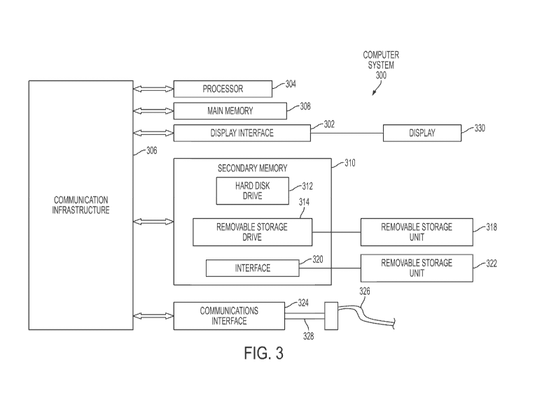
Turning to Figure 3, Figure 3 is a functional block diagram for a computer
system
300 for implementation of an exemplary embodiment or portion of an embodiment
of present
invention. For example, a method or system of an embodiment of the present
invention may
be implemented using hardware, software or a combination thereof and may be
implemented
in one or more computer systems or other processing systems, such as personal
digit
assistants (PDAs) equipped with adequate memory and processing capabilities.
In an
14
CA 02812950 2013-03-27
WO 2012/050932
PCT/US2011/053788
example embodiment, the invention was implemented in software running on a
general
purpose computer 30 as illustrated in Figure 3. The computer system 300 may
includes one
or more processors, such as processor 304. The Processor 304 is connected to a
communication infrastructure 306 (e.g., a communications bus, cross-over bar,
or network).
The computer system 300 may include a display interface 302 that forwards
graphics, text,
and/or other data from the communication infrastructure 306 (or from a frame
buffer not
shown) for display on the display unit 330. Display unit 330 may be digital
and/or analog.
The computer system 300 may also include a main memory 308, preferably random
access memory (RAM), and may also include a secondary memory 310. The
secondary
memory 310 may include, for example, a hard disk drive 312 and/or a removable
storage
drive 314, representing a floppy disk drive, a magnetic tape drive, an optical
disk drive, a
flash memory, etc. The removable storage drive 314 reads from and/or writes to
a removable
storage unit 318 in a well known manner. Removable storage unit 318,
represents a floppy
disk, magnetic tape, optical disk, etc. which is read by and written to by
removable storage
drive 314. As will be appreciated, the removable storage unit 318 includes a
computer usable
storage medium having stored therein computer software and/or data.
In alternative embodiments, secondary memory 310 may include other means for
allowing computer programs or other instructions to be loaded into computer
system 300.
Such means may include, for example, a removable storage unit 322 and an
interface 320.
Examples of such removable storage units/interfaces include a program
cartridge and
cartridge interface (such as that found in video game devices), a removable
memory chip
(such as a ROM, PROM, EPROM or EEPROM) and associated socket, and other
removable
storage units 322 and interfaces 320 which allow software and data to be
transferred from the
removable storage unit 322 to computer system 300.
The computer system 300 may also include a communications interface 324.
Communications interface 324 allows software and data to be transferred
between computer
system 300 and external devices. Examples of communications interface 324 may
include a
modem, a network interface (such as an Ethernet card), a communications port
(e.g., serial or
parallel, etc.), a PCMCIA slot and card, a modem, etc. Software and data
transferred via
communications interface 324 are in the form of signals 328 which may be
electronic,
electromagnetic, optical or other signals capable of being received by
communications
interface 324. Signals 328 are provided to communications interface 324 via a
communications path (i.e., channel) 326. Channel 326 (or any other
communication means
CA 02812950 2013-03-27
WO 2012/050932
PCT/US2011/053788
or channel disclosed herein) carries signals 328 and may be implemented using
wire or cable,
fiber optics, blue tooth, a phone line, a cellular phone link, an RF link, an
infrared link,
wireless liffl( or connection and other communications channels.
In this document, the terms "computer program medium" and "computer usable
medium" are used to generally refer to media or medium such as various
software, firmware,
disks, drives, removable storage drive 314, a hard disk installed in hard disk
drive 312, and
signals. These computer program products ("computer program medium" and
"computer
usable medium") are means for providing software to computer system 300. The
computer
program product may comprise a computer useable medium having computer program
logic
thereon. The invention includes such computer program products. The "computer
program
product" and "computer useable medium" may be any computer readable medium
having
computer logic thereon.
Computer programs (also called computer control logic or computer program
logic)
may be stored in main memory 308 and/or secondary memory 310. Computer
programs may
also be received via communications interface 324. Such computer programs,
when
executed, enable computer system 300 to perform the features of the present
invention as
discussed herein. In particular, the computer programs, when executed, enable
processor 304
to perform the functions of the present invention. Accordingly, such computer
programs
represent controllers of computer system 300.
In an embodiment where the invention is implemented using software, the
software
may be stored in a computer program product and loaded into computer system
300 using
removable storage drive 314, hard drive 312 or communications interface 324.
The control
logic (software or computer program logic), when executed by the processor
304, causes the
processor 304 to perform the functions of the invention as described herein.
In another embodiment, the invention is implemented primarily in hardware
using, for
example, hardware components such as application specific integrated circuits
(ASICs).
Implementation of the hardware state machine to perform the functions
described herein will
be apparent to persons skilled in the relevant art(s).
In yet another embodiment, the invention is implemented using a combination of
both
hardware and software.
In an example software embodiment of the invention, the methods described
above
may be implemented in SPSS control language or C + + programming language, but
could be
implemented in other various programs, computer simulation and computer-aided
design,
16
CA 02812950 2013-03-27
WO 2012/050932
PCT/US2011/053788
computer simulation environment, MATLAB, or any other software platform or
program,
windows interface or operating system (or other operating system) or other
programs known
or available to those skilled in the art.
Figure 4 is a schematic block diagram for a system or related method of an
embodiment of the present invention in whole or in part. Referring to Figure
4, provided is a
schematic of an approach of the digital map optimization system 410 to be
applied onto a first
route planning digital map as provided by way of input module, for example
keyboard 414,
mouse 416, and/or touch screen 418. Other examples of input modules (not
specifically
illustrated) include, but not limited thereto, trackball, stylus, touch pad,
steering wheel
buttons, microphone, joystick, game pad, satellite dish, scanner, TV tuner
card, digital
camera, digital video camera, web camera, remote control, and the like. Input
function may
also be accomplished via the server 432, user 472, tracking module 482, or
auxiliary module
492, or some combination thereof. The server 432 is equipped with the
prerequisite web
software, hardware or firmware and the PC 424 may be equipped with the
necessary browser
software. Similarly, any of the related input functions or modules of Figure 4
(as well as
discussed throughout this disclosure) may be supported by the adequate
software, hardware
or firmware. By way of the input module a first route planning digital map,
among other
things, is received by the processor, such as a personal computer 424 (or any
processing
system, such as PDAs, equipped with adequate memory and processing
capabilities) and
includes a collection of nodes and arcs whereby an arc is defined as a segment
between a pair
of nodes. An algorithm as it pertains to related method as discussed
throughout this
disclosure is implemented at the PC 424 for instance. Alternatively, the
algorithm may be
implemented at the PC or remotely at the server 430, tracking module 482, or
auxiliary
module 492, or some combination thereof Next, the assigned arc costs are
applied to the
first route planning digital map to provide an optimized route planning
digital map. Storage
capabilities are provided for, among other things, storing the optimized route
planning digital
map by way of a memory (not shown) as part of the PC or outputted to an
external memory
module 442, or a secondary memory module (not shown), to the server 432, the
user 472,
tracking module 482, or auxiliary module 492, as well as a combination of
utilizing any of
the memory modules discussed herein. Alternatively, or in addition to the
aforementioned
memory modules, an output module may be provided for outputting the optimized
route
planning digital map for use through a monitor 462 and/or printer 464, as well
as any
graphical user interface.
17
CA 02812950 2013-03-27
WO 2012/050932
PCT/US2011/053788
Still refereeing to Figure 4, the preferred route data that is received by the
processor
can be received by any input mechanism such as from the input modules, server
432, user
472, auxiliary module 492, or tracking module 482. The source for the
preferred data, for
instance, may be manual communication entry; GPS communication; intern&
communication, or memory storage of preferred route data. Still yet, the
source for the
preferred data, for instance, may be from a triangulation system,
accelerometer, or gyro. An
example of a tacking module 482 is, but not limited thereto, a GPS or
triangulation via
cellular stations.
It should be appreciated that the various communication paths, links and
channels
shown between all of the modules, equipment or devices illustrated in Figures
1 and 4-8 may
be implemented using a variety of means adequate for transferring or
communicating signals
or data, including, but not limited thereto, the following: wire, cable,
internet, wireless, fiber
optic, blue tooth, telephone line, cellular phone link, RF link, and infrared
link, as well as any
other available means of communication.
It should be appreciated that the auxiliary module discussed herein may be any
combination of at least one of the following: input module, output module,
processor module,
server module, satellite system, GPS, mobile phone, PDA, tracking module,
communication
system, vehicle system, navigation system, storage medium, internet-enabled
device, or
database.
Figure 5 is a schematic block diagram for a system or related method of an
embodiment of the digital map optimization system 510 similarly disclosed in
Figure 4 with
a modification that additional aspects may be performed remotely such as on
various servers.
For instance, a number of modules are associated remotely with a server 533.
The system
510 may be implemented with a variety of modules such as tracking module 582;
server 532;
user 572; auxiliary module 592; input module 512 or related function; software
518 including
code 518 and data 520; memory 522; processor 514 with an associated processing
unit 515;
output module 522 or related function; and server 533.
Figure 6 is a schematic block diagram for a system or related method of an
embodiment of the present invention in whole or in part. Figure 6 provides an
illustration of
an approach whereby, for example but not limited thereto, navigation systems
can use an
embodiment of the present invention digital map optimization system 610 and
related method
to improve the relevance of their route guidance. Users 694 of their
respective navigation
systems 622 (for example, stand alone navigations such GPS) upload data on
their traveled
18
CA 02812950 2013-03-27
WO 2012/050932
PCT/US2011/053788
(captured) routes 623 to the navigation system manufacturer module 632 (such
as the GPS
manufacture's server). This data (captured data) 625 on traveled routes is
provided to the
digital map optimization system 610 to be received by the stored route
database 632. The
digital map optimization system 610 system selects arc costs on a digital map
that are
consistent with the traveled routes using the optimization algorithm 634 to
compute the
optimized digital map stored in the optimized digital map data base 636. These
new arc costs
(in the form of digital map updates or optimized digital maps 638) are
returned to the
navigation system manufacturer 632. The navigation system manufacturer 632
provides the
map updates 638 to its users 694 at the stand-alone navigation systems 622.
Figure 7 is a schematic block diagram for a system or related method of an
embodiment of the present invention in whole or in part. Figure 7 provides an
illustration of
an approach that, for example but not limited thereto, an embodiment of the
present invention
digital map optimization system 710 and related method can be utilized to use
multiple,
existing data sources to improve existing digital maps. Data that is currently
collected by
service vehicles 724, smartphones or PDAs 726, and cell phone triangulation
(or other
applicable location data) 728 is provided to the system 710. This data is
processed 732to
segment into individual routes on a digital map. For instance this may include
processing to
obtain a common format. The system selects arc costs on a digital map from a
stored route
data base 736 that are consistent with the traveled routes. The optimization
algorithm 742
computes the optimized digital maps as it is in communication with digital map
database 752.
This updated map can be supplied to multiple consumers of digital maps, such
as web-based
mapping services 764 and mapping applications for smartphones or PDAs 766.
Additionally,
updated maps could be supplied directly to providers of digital map data 762.
Figure 8 is a schematic block diagram for a system or related method of an
embodiment of the present invention in whole or in part. Figure 8 provides an
illustration of
an approach whereby an embodiment of the present invention digital map
optimization
system 810 and related method can be utilized by, for example but not limited
thereto, a fleet
management system 826 so as to improve the relevance of their route guidance,
improve
delivery scheduling 832, and evaluate driver performance 834. Fleet vehicle
routes are
monitored and stored by existing fleet management systems 826. This captured
route data
825 on fleet vehicle routes from the vehicles 824 used by users 894 is
provided as stored
routed data 842 to the system 810. The system 810 selects arc costs on a
digital map from the
digital map data base 844 using the optimization algorithm 846 that are
consistent with the
19
CA 02812950 2013-03-27
WO 2012/050932
PCT/US2011/053788
traveled routes. (4) These new arc costs¨as digital map updates 848--are
returned to the fleet
management system 826. (5) The fleet management system 826 uses the updated
map for
route guidance 852, delivery scheduling 832, and driver performance evaluation
834.
An aspect of an embodiment of the present invention provides a system, method
and
computer program product for developing and/or maintaining a route planning
digital map.
Moreover, the route planning digital map may serve as the reference basis for
location-based
systems such as, but not limited to, route guidance, multi-modal
transportation system
monitoring, location-based consumer applications, and vehicle fleet
administration. An
exemplary embodiment may include providing the optimized route planning data
to a
location-based consumer application such as a store front, business front, or
marketing
application. A marketing application, for example, may utilize any route,
driver, entity, or
user information that can be provided for purpose of applying marketing
practices (or other
desired or required business practices); and whereby the route, driver,
entity, or user
information is gleamed, derived, or generated from the optimizing route
planning data.
It should be appreciated that the term "arc cost" is interchangeable with the
term
"edge cost." It should be appreciated that the term "arc" is interchangeable
with the term
"edge." It should be appreciated that "arc costs" are interchangeable with the
term "arc
weight." For purpose of this disclosure, the term "road" shall also be
interpreted to include
the following terms: road, bridge, tunnel, path, patch, pathway, trail,
street, walkway, track,
region, flight corridor, or segment. A region may be, for example, but not
limited thereto,
military deployment regions, other types of military regions, as well as
various other general
types of designated regions or areas of interest. An exemplary region may be
areas that are
occupied, such as stores, offices, malls, crowds, and congregations. The
tracking of
occupants (human, animal, etc.), for example, could be accomplished by visual
and
recognition tracking software. For the purpose of this disclosure "vehicle"
shall include
manned or un-manned automobile, aircraft, spacecraft, watercraft, motorcycle,
bicycle, robot,
or personnel body-based (whereby besides being based on humans, it could also
be based on
animals, reptiles or amphibians). For the purpose of this disclosure, the
segments or arcs
may be applicable for land, sea, space, or air.
EXAMPLES
Practice of an aspect of an embodiment (or embodiments) of the invention will
be still
more fully understood from the following examples and experimental results,
which are
CA 02812950 2013-03-27
WO 2012/050932
PCT/US2011/053788
presented herein for illustration only and should not be construed as limiting
the invention in
any way.
Experimental Results and Examples Set No. 1
Figure 10 represents an optimized route planning map for San Francisco, CA
generated by the use of an embodiment of the present invention digital map
optimization
system or method. An aspect of the preferred data originated from the use of
real-world data
(taxi cabs) sample. The map illustrates the optimized route whereby the route
is not
necessarily the shortest available route (between the starting point, S, and
destination point,
D), but rather the most preferred route based on the algorithm of an
embodiment generating
the optimum route planning digital map.
Experimental Results and Examples Set No. 2
Figure 11 represents an optimized route planning map for San Francisco, CA
generated by the use of an embodiment of the present invention digital map
optimization
system or method, which provides a comparison to the generated conventional
suggested
route denoted as CS. The map illustrates the optimized route whereby the
optimized route is
not necessarily the route (between the starting point, S, and destination
point, D) having the
greatest speed limit, but rather the most preferred route based on the
algorithm of an
embodiment generating the optimum route planning digital map. Accordingly, the
optimized
route requires about 11.5 minutes of travel time versus the conventional
suggested route, CS,
that requires 15.4 minutes of travel.
Experimental Results and Examples Set No. 3
Figure 12 represents a portion of a route planning map for San Francisco, CA
identifying segments to be avoided, as denoted Al, A2, A3, and A4, as detected
by using the
algorithm of an embodiment used at least in part for generating the optimized
planning digital
map.
Experimental Results and Examples Set Nos. 4-7
Figures 13-16 each represents a route planning map for San Francisco, CA
generated
by the use of an embodiment of the present invention digital map optimization
system or
method, which provides a comparison to the generated conventional suggested
route, CS.
The map illustrates the optimized route whereby the optimized route is not
necessarily the
route having the greatest speed limit or shortest distance, for example, but
rather the most
preferred route based on the algorithm of an embodiment generating the optimum
route
planning digital map.
21
CA 02812950 2013-03-27
WO 2012/050932
PCT/US2011/053788
The devices, systems, compositions, computer program products, and methods of
various embodiments of the invention disclosed herein may utilize aspects
disclosed in the
following references, applications, publications and patents and which are
hereby
incorporated by reference herein in their entirety:
1. U.S. Patent Application Publication No. US 2008/0033633 Al, Akiyoshi, et
al.,
"Guide Route Search Device and Guide Route Search Method", February 7, 2008;
U.S.
Patent Application Serial No. 10/574,k1015, filed October 19, 2006.
2. U.S. Patent No. US 7,062,376 B2, Oesterling, "Method and System For
Providing
A Carpool Service Using A Telematics System", June 13, 2006.
3. U.S. Patent No. US 7,577,244 B2, Taschereau, "Method and System For
Providing
Geographically Targeted Information and Advertising", August 18, 2009.
4. U.S. Patent No. US 7,225,076 B2, Sugawara, "Map Search System", May 29,
2007.
5. U.S. Patent No. US 5,177,685, Davis, et al., "Automobile Navigation System
Using Real Time Spoken Driving Instructions", January 5, 1993.
6. U.S. Patent Application Publication No. US 2008/0172172 Al, NG, "Route
Planning Process", July 17, 2008; U.S. Patent Application Serial No.
12/004,516, filed
December 21, 2007.
7. European Patent Application Publication No. EP 0 317 181 Bl, Tarrant, "Road
Vehicle Route Selection and Guidance Systems", January 19, 1994; EP Patent
Application
Serial No. 88310624.7, filed November 10, 1988.
8. U.S. Application Publication No. US 2009/0175172 Al, Prytz, et al., "Method
and
Arrangement for Route Cost Determination and Selection with Link Cost
Interaction", July 9,
2009; U.S. Patent Application Serial No. 11/917,112, filed May 30, 2008.
9. U.S. Patent No. US 6,633,812 Bl, Martin, et al., "Method For Influencing
Source
Date For Determining A Route in A Naviation System", October 14, 2003.
10. U.S. Patent Application Publication No. US 2008/0270019 Al, Anderson, et
al.,
"Systems and Methods for Enhancing Private Transportation", October 30, 2008;
U.S. Patent
Application Serial No. 12/005,845, filed December 28, 2007.
11. U.S. Patent No. 7,577,108 B2, Zhang, et al., "Learning-Based Strategies
For
Message-Initiated Constraint-Based Routing", August 18, 2009.
22
CA 02812950 2013-03-27
WO 2012/050932
PCT/US2011/053788
12. U.S. Patent Application Publication No. US 2009/0271104 Al, Letchner, et
al.,
"Collaborative Route Planning For Generating Personalized and Context-
Sensitive Routing
Recommendations", October 29, 2009; U.S. Patent Application Serial No.
12/466,308, filed
May 14, 2009.
13. U.S. Patent No. US 7,610,151 B2, Letchner, et al., "Collaborative Route
Planning
For Generating Personalized and Context-Sensitive Routing Recommendations",
October 27,
2009.
14. Google Map Maker
15. U.S. Patent Application Publication No. US 2010/0131186 Al, Geelen, et
al.,
"Method of Generating Improved Map Data For Use in Navigation Devices, Map
Data and
Navigation Device Therefore", May 27, 2010; U.S. Patent Application Serial No.
12/310,102,
filed January 25, 2010.
16. U.S. Patent Application Publication No. US 2010/0131189 Al, Geelen, et
al.,
"Method of Generating Improved Map Data for Use in Navigation Devices and
Navigation
Device With Improved Map Data", May 27, 2010; U.S. Patent Application Serial
No.
12/310,064, filed January 25, 2010.
17. U.S. Patent Application Publication No. US 2008/0082225 Al, Barrett, "A
Method of Reporting Errors in Map Data Used by Navigation Devices"; U.S.
Patent
Application Serial No. 11/464,609, filed August 15, 2006.
18. International Patent Application Publication No. WO 2008/019885 Al,
Geelen, et
al., "A Method of Generating Improved Map Data For Use in Navigation Devices",
February
21, 2008; International Patent Application Serial No. PCT/EP2007/007311, filed
August 15,
2007.
In summary, while the present invention has been described with respect to
specific
embodiments, many modifications, variations, alterations, substitutions, and
equivalents will
be apparent to those skilled in the art. The present invention is not to be
limited in scope by
the specific embodiment described herein. Indeed, various modifications of the
present
invention, in addition to those described herein, will be apparent to those of
skill in the art
from the foregoing description and accompanying drawings. Accordingly, the
invention is to
be considered as limited only by the spirit and scope of the following claims,
including all
modifications and equivalents.
23
CA 02812950 2013-03-27
WO 2012/050932
PCT/US2011/053788
Still other embodiments will become readily apparent to those skilled in this
art from
reading the above-recited detailed description and drawings of certain
exemplary
embodiments. It should be understood that numerous variations, modifications,
and
additional embodiments are possible, and accordingly, all such variations,
modifications, and
embodiments are to be regarded as being within the spirit and scope of this
application. For
example, regardless of the content of any portion (e.g., title, field,
background, summary,
abstract, drawing figure, etc.) of this application, unless clearly specified
to the contrary, there
is no requirement for the inclusion in any claim herein or of any application
claiming priority
hereto of any particular described or illustrated activity or element, any
particular sequence of
such activities, or any particular interrelationship of such elements.
Moreover, any activity
can be repeated, any activity can be performed by multiple entities, and/or
any element can
be duplicated. Further, any activity or element can be excluded, the sequence
of activities can
vary, and/or the interrelationship of elements can vary. Unless clearly
specified to the
contrary, there is no requirement for any particular described or illustrated
activity or element,
any particular sequence or such activities, any particular size, speed,
material, dimension or
frequency, or any particularly interrelationship of such elements.
Accordingly, the
descriptions and drawings are to be regarded as illustrative in nature, and
not as restrictive.
Moreover, when any number or range is described herein, unless clearly stated
otherwise, that
number or range is approximate. When any range is described herein, unless
clearly stated
otherwise, that range includes all values therein and all sub ranges therein.
Any information
in any material (e.g., a United States/foreign patent, United States/foreign
patent application,
book, article, etc.) that has been incorporated by reference herein, is only
incorporated by
reference to the extent that no conflict exists between such information and
the other
statements and drawings set forth herein. In the event of such conflict,
including a conflict
that would render invalid any claim herein or seeking priority hereto, then
any such
conflicting information in such incorporated by reference material is
specifically not
incorporated by reference herein.
24