Note: Descriptions are shown in the official language in which they were submitted.
CA 02813223 2013-03-28
WO 2012/044833 PCT/US2011/054031
- 1 -
VARIABLE PRODUCT AGROCHEMICALS APPLICATION MANAGEMENT
CROSS-REFERENCE TO RELATED APPLICATIONS
This Application claims the benefit of priority to U.S. Nonprovisional
Application 13/027,435 filed February 15, 2011, which claims the benefit of
priority to U.S.
Provisional Application 61/388,414, filed September 30, 2010.
SUMMARY OF THE INVENTION
Embodiments of our technology are defined by the claims below, not this
summary. A high-level overview of various aspects of our technology are
provided here for
that reason, to provide an overview of the disclosure, and to introduce a
selection of concepts
that are further described below in the detailed-description section. This
summary is not
intended to identify key features or essential features of the claimed subject
matter, nor is it
intended to be used as an aid in isolation to determine the scope of the
claimed subject matter.
In brief and at a high level, this disclosure describes, among other things,
ways to assist a
grower in developing and implementing strategies for agrochemical application.
In brief, embodiments of the technologies described herein provide ways to
facilitate variable-product agrochemicals application. In one embodiment, a
field (or area of
land) is delineated and mapped into zones of ground, that are suitable for
receiving a certain
agrochemical, based on characteristics of the ground within the zones. For
example, the
agrochemical might be a fertilizer and the zones might represent areas of the
field that are
vulnerable to fertilizer loss due to soil characteristics. Using information
about the delineated
zones, appropriate mixture ratios or rates of fertilizer to be applied to
areas of the field are
determined. For example, areas within zones of land susceptible to fertilizer
loss might be
determined to receive specially adapted or enhanced efficiency fertilizer,
while areas within
zones of ground that are not susceptible to fertilizer loss might be
determined to receive a
conventional fertilizer. The determined fertilizer application sources,
mixture ratios, and
rates, which we refer to as the "fertilizer product," can be presented as a
schedule or listing or
visually as a geographically referenced map of the field, showing which areas
of the field are
to receive the determined fertilizer products. This map, or other information
representing the
determined fertilizer products can also be transferred in an appropriate form
to a controller of
a fertilizer applicator, thereby enabling fertilizer to be applied to the
field consistent with the
81770250
- 2 -
determined ratios and rates of the fertilizer products. Additionally, the map,
or other
information representing the determined fertilizer products, may be stored for
record keeping
or used for reporting, evaluating application strategies, or other analysis.
For example, the
map may be used as an overlay onto a map showing crop yields within the field.
According to one aspect of the present invention, there is provided computer-
readable media having computer-executable instructions embodied thereon that
when
executed, facilitate a method of applying fertilizer to a fertilizer-
application area that is made
up of a plurality of discrete land units, the method comprising: determining
an attribute value
for each land unit that quantifies a degree to which the land unit possesses a
certain
characteristic, thereby resulting in a set of attribute values; delineating a
first zone based on
said set of attribute values, wherein said first zone is made up of land that
shares substantially
similar attribute values; from a set of fertilizer-application parameters,
based on a subset of
fertilizer-application parameters that relate to limitations of physically
applying fertilizer to
the land, logically partitioning said application area into a set of
application cells ("application
cells"); (1) wherein at least a portion of said first zone falls within at
least one application cell
of said set of application cells; and (2) wherein said application cell
encompasses a subset of
the plurality of discrete land units, thereby resulting in a subset of
attribute values that are
associated with said application cell; receiving at least one fertilizer-
application parameter
from said set of application parameters; from among a number of fertilizer
types, determining
a product of fertilizer to be applied to said application cell based on said
subset of attribute
values and at least one fertilizer-application parameter; and generating
controller information
that is usable by a fertilizer applicator to apply fertilizer to said
application cell consistent
with said determined product of fertilizer; wherein said attribute value
comprises a wetness-
index value; wherein said at least one fertilizer-application parameter
includes a wetness-
index threshold; and further comprising: comparing said wetness-index
threshold to at least
one attribute value of said first zone; based on said comparison, designating
said first zone for
receiving a certain fertilizer type; wherein said product of fertilizer to be
applied to said
application cell is further determined based on said first-zone designation
and said portion of
said first zone falling within said application
cell.
CA 2813223 2017-11-23
81770250
- 2a -
According to another aspect of the present invention, there is provided
computer-
readable media having computer-executable instructions embodied thereon that
when
executed, facilitate a method of managing application of fertilizer to an area
made up of a
plurality of location points of land, the method comprising: determining an
attribute value, for
each location point of said plurality of location points in an application
area, that represents a
degree to which said location point possesses a certain characteristic,
thereby resulting in a set
of attribute values; delineating a first zone based on said set of attribute
values, wherein said
first zone is made up of location points having attribute values belonging to
a similar range of
values; from a set of fertilizer-application parameters, based on a subset of
fertilizer-
application parameters that relate to limitations of physically applying
fertilizer, logically
partitioning said application area to define at least one application cell;
(1) wherein at least a
portion of said first zone falls within said at least one application cell;
and (2) wherein said at
least one application cell encompasses a subset of the plurality of location
points, thereby
resulting in a subset of attribute values that are associated with said at
least one application
cell; receiving at least one fertilizer-application parameter from said set of
application
parameters; from among a number of fertilizer types, determining an
application schedule of
fertilizer to be applied to said application cell based on said subset of
attribute values and at
least one fertilizer-application parameter; and generating controller-
information that is usable
by a fertilizer applicator to apply fertilizer to said application cell
consistent with said
determined application schedule; wherein said at least one fertilizer-
application parameter
includes an attribute-value threshold; and further comprising: comparing said
attribute-value
threshold to an attribute value representative of said first zone; based on
said comparison,
designating said first zone for receiving a certain fertilizer type; and
wherein said application
schedule of fertilizer to be applied to said application cell is further
determined based on said
first zone's designation and said portion of said first zone falling within
said application cell.
According to still another aspect of the present invention, there is provided
computer-readable media having computer-executable instructions embodied
thereon that
when executed, facilitate a method of applying fertilizer to an area that is
made up of a
plurality of discrete land units, the method comprising: determining a value
of a wetness index
for each land unit thereby resulting in a set of wetness-index values;
delineating a first zone of
CA 2813223 2017-11-23
81770250
- 2b -
ground based on said wetness-index values, wherein said first zone is
substantially made up of
ground having wetness-index values of a similar range within said wetness
index; based on a
subset of fertilizer-application parameters that relate to limitations of
physically applying
fertilizer to ground, logically partitioning said application area to define
an application cell;
(1) wherein at least a portion of said first zone falls within said
application cell; and (2)
wherein said application cell encompasses a subset of the plurality of
discrete land units,
thereby resulting in a subset of wetness-index values associated with said
application cell;
receiving at least one fertilizer-application parameter including a wetness-
index threshold;
comparing said wetness-index threshold to a value representing said wetness-
index values of
said portion of said first zone within said application cell; based on said
comparison,
designating said first zone for receiving an enhanced-type fertilizer or a
conventional-type
fertilizer; from among a number of fertilizer types, determining a product of
fertilizer to be
applied to said application cell based on said subset of wetness-index values
and said first-
zone designation; and generating controller information that is usable by a
fertilizer applicator
to apply fertilizer to said application cell consistent with said determined
product of fertilizer.
BRIEF DESCRIPTION OF THE DRAWING
Illustrative embodiments of the present invention are described in detail
below with
reference to the attached drawing figures, which are incorporated by reference
herein and
wherein:
FIGs. IA and 1B depict aspects of an illustrative operating environment
suitable for
practicing an embodiment of our technology;
FIG. 1C depicts an area of land suitable for receiving fertilizer application
in
accordance with embodiments of the present invention;
FIG. 2A depicts areas of land suitable for receiving fertilizer application,
an example
mapping of fertilizer-application cells, and fertilizer application by a
fertilizer applicator in
accordance with embodiments of the present invention;
CA 2813223 2017-11-23
= 81770250
- 2c -
FIGs. 213-2E depict areas of land suitable for receiving fertilizer
application and an
example mapping of fertilizer-application cells in accordance with embodiments
of the present
invention;
FIG. 3 depicts an illustrative process flow-diagram that illustrates an
embodiment of
facilitating a method of ultimately applying variable-product fertilizer to an
application area;
FIG. 4 depicts a method by which the present invention may be used in order to
apply
fertilizer to an application area.
FIG. 5 depicts a method by which the present invention may be used in order to
apply
fertilizer to an application area.
FIG. 6 depicts a method by which the present invention may be used in order to
determine attribute values;
FIGs. 7A-7C depict methods by which the present invention may be used in order
to
delineate a zone;
FIG. 8 depicts a method by which the present invention may be used in order to
partition an application area into application cells; and
CA 2813223 2017-11-23
CA 02813223 2013-03-28
WO 2012/044833 PCT/US2011/054031
- 3 -
FIG. 9 depicts a method by which the present invention may be used in order
to determine a fertilizer product for applying to an application cell.
DETAILED DESCRIPTION OF THE INVENTION
The subject matter of the present technology is described with specificity
herein to meet statutory requirements. However, the description itself is not
intended to
define the technology, which is what the claims do. Rather, the claimed
subject matter might
be embodied in other ways to include different steps or combinations of steps
similar to the
ones described in this document, in conjunction with other present or future
technologies.
Moreover, although the term "step" or other generic term might be used herein
to connote
different components or methods employed, the terms should not be interpreted
as implying
any particular order among or between various steps herein disclosed unless
and except when
the order of individual steps is explicitly described.
Acronyms and Shorthand Notations
Throughout the description of the present invention, several acronyms,
shorthand notations, and terms are used to aid the understanding of certain
concepts
pertaining to the associated system and services. These acronyms. shorthand
notations, and
terms are solely intended for the purpose of providing an easy methodology of
communicating the ideas expressed herein and are in no way meant to limit the
scope of the
present invention. The table below does not include a full definition. A full
definition of any
term can only be gleaned by giving consideration to the full breadth of this
patent.
Sometimes, we use different terms to refer to similar or the same things. We
do not necessarily mean to implicate a difference, per se; but are constrained
by certain
statutory requirements that apply to patents and patent applications. For
example, claims
must use proper antecedent basis. Sometimes satisfying that rule can lead to
wordiness,
whereas using a different word helps make referring to prior terms easier.
Thus we might use
different words in that regard. The following is a list of these terms:
TABLE 1
DEM Digital Elevation Model
TWI Topographic Wetness Index
Agrochemical A substance able to be applied to an application
area, and which may be solid, liquid, gaseous, or a
combination of one or more solid, liquid, or gaseous
CA 02813223 2013-03-28
WO 2012/044833
PCT/US2011/054031
- 4 -
substances including, for example, fertilizers,
herbicides, pesticides, other crop protection
chemicals, erosion control or other surface control
substances, conditioners, nutrients, minerals,
neutralizers, soil additives, amendments, or similar
substances.
Fertilizer, A type of agrochemical for application to an
Fertilizer Source application area. It is contemplated that in some
embodiments, the term "fertilizer" includes any
agrochemical of combination of agrochemicals.
Application Area An area of land suitable for receiving an application
of an agrochemical, and which might include one or
more fields, pastures, orchards, courts, golf courses,
yards, lawns, planting or cultivating beds, lots, or
similar areas of land, or a portion of such an area.
Discrete Land A discrete portion of land located within an
Unit application area associated with one or more
attribute values.
Location Point A location in an application area that has an
associated attribute value corresponding to a degree
of expression of an attribute at that location. For
example, location points may represent locations in
an application area corresponding to measurements
of an attribute, such as soil pH-level measurements,
vegetation, soil structure, or other attributes, and
may be uniformly spatially distributed or located
wherever attribute data, such as field measurements
of attributes, are available. They may be more
densely located around areas where an attribute has
a greater variance and may be more spread apart in
areas where the attribute varies less.
Attribute Value An attribute value corresponds to a degree of
expression of an attribute present at a location point
or within a discrete land unit of an application area.
An attribute value may be expressed as numerical
quantity (e.g., "6" or "20%") or as a classification
(e.g. "acidic" or "sandy"), and may be derived from
a measurement of an attribute at a single point
within a discrete land unit or may be an average,
median, or similar representative value of the degree
of expression of an attribute possessed by a discrete
land unit. An attribute value also may be
represented as an index value, which corresponds to
an index that represents degrees of expression of an
attribute. A set of attribute values, corresponding to
a plurality of discrete land units or location points in
CA 02813223 2013-03-28
WO 2012/044833
PCT/US2011/054031
- 5 -
an application area, may be characterized or
represented as an attribute grid, with each point on
the grid corresponding to a location of a discrete
land unit or location point having an associated
attribute value.
Attribute Zone An area of land in an application area that has
similar attribute values. For example, in one
embodiment, zones are made up of substantially
contiguous discrete land units having substantially
similar attribute values or having attribute values
corresponding to the same attribute classification,
such as "acid" or "alkaline.
Application-Area Application-area information includes attribute
Information information corresponding to characteristics of the
application area. In some embodiments this includes
attribute values that are geographically referenced
within the application-area or associated with
location information. Application-area information
may further include other geographic information of
application area such as its geographic location,
proximity to streams, roads, wetlands, or similar
features. Application-area information can, in some
embodiments, also comprise one or more sets of
measured or determinable values of a characteristic
or attribute at locations in an application area. For
example, for the attribute of soil acidity or alkalinity,
application-area information might include a set of
attribute values representing the location and
measured soil pH-levels of various location points in
the application area.
Fertilizer Product, A determined fertilizer or agrochemical application
Agrochemical for an application cell. A fertilizer (or
product agrochemical) product can include the source(s) or
type(s) of fertilizer, and can also include the quantity
or volume of fertilizer, application rate, and
fertilizer-mixture information such as a proportion
of mixed fertilizer types.
In one embodiment, a fertilizer product is
determined for each application cell in an
application area. A fertilizer product, or a set of
fertilizer products for multiple application cells, may
be formatted as a schedule showing application
levels, rates, mixture ratios, quantities, total
amounts, or sources.
Application Cell A portion of ground that will receive a certain
product of fertilizer. The boundaries of an
CA 02813223 2013-03-28
WO 2012/044833
PCT/US2011/054031
- 6 -
application cell may be determined by the physical
reach or other limitations of a fertilizer applicator,
user preferences, or by other application parameters,
in one embodiment.
Application Strip A row of partitioned application cells of uniform
width. An application strip represents an area of
ground covered by a single pass of a fertilizer
applicator. By way of example, applying fertilizer to
an application area may be accomplished by a series
of back-and-forth passes over the application area, to
ensure the entire application area receives fertilizer.
Fertilizer- Parameters, which in some embodiments are used,
Application along with the application-area information to
Parameters determine the fertilizer-application information,
which will be used for apply fertilizer to each
application cell. Fertilizer-application parameters
comprise information such as (1) indications of
fertilizer-applicator equipment which might affect
the application cell size; (2) user application
preferences such as a risk-avoidance level for
known risk areas, fertilizer-application products,
preferred fertilizer types, user-specified buffer areas,
and application-cell size (3) available fertilizer
types; (4) rates and ratios of fertilizer types to apply
for given application-area characteristics; (5)
attribute thresholds or index thresholds; (6)
information about the type of crop that will be
grown in the application cell; (7) historical data such
as previous parameters, previous application rates
and ratios, and past crop yields; (8) economic
parameters such as the cost of the fertilizer or cost-
benefit analyses of the cost for applying a particular
fertilizer to an application cell verses the expected
gain from an improved crop-yield from that cell; (9)
government regulations (which, for example, might
limit the amount or location of certain types of
fertilizer sources that can be applied); and (10) local
geographic information (such as a nearby stream or
wetlands that might affect which fertilizer is to be
applied to adjacent application cells.
Equipment Equipment parameters are a subset of fertilizer-
Parameters application parameters and include parameters
relating to the fertilizer-applicator equipment and
other parameters affecting the physical limitations of
applying fertilizer. For example, equipment
parameters may include the reach or coverage-area
of an applicator for given types of fertilizer or
CA 02813223 2013-03-28
WO 2012/044833
PCT/US2011/054031
- 7 -
information which can be used to determine an
applicator's reach or coverage-width, such as a
model number of a fertilizer applicator.
Fertilizer- Information including the results of the process for
Application determining a fertilizer product to apply to an
Information application cell based on application-area
information and, in one embodiment, fertilizer-
application parameters. Fertilizer-application
information can include information specifying a
product of fertilizer to apply in an application cell
such as the source(s) or type(s) of fertilizer, the
quantity of fertilizer, application rate, and fertilizer-
mixture information such as a proportion of mixed
fertilizer types.
In one embodiment, fertilizer-application
information also specifies location information for
the application cell; in one embodiment it also
includes other information such as the results of
additional analysis performed using fertilizer
application information.
Fertilizer Product, A determined fertilizer or agrochemical application
Agrochemical for an application cell. A fertilizer (or
product agrochemical) product can include the source(s) or
type(s) of fertilizer, and can also include the quantity
or volume of fertilizer, application rate, and
fertilizer-mixture information such as a proportion
of mixed fertilizer types.
In one embodiment, a fertilizer product is
determined for each application cell in an
application area. A fertilizer product, or a set of
fertilizer products for multiple application cells, may
be formatted as a schedule showing application
levels, rates, mixture rations, quantities, total
amounts, or sources.
Fertilizer A collection of information specifying fertilizer-
Application application information, including the determined
Schedule fertilizer (or agrochemical) product to be applied for
each application cell, of a set of application cells, in
an application area. The schedule can include, in
one embodiment, information specifying for each
application cell, a product of fertilizer to apply, or a
quantity and fertilizer type or types, rate and a
mixture ratio, if a mixture of fertilizer types is to be
applied.
CA 02813223 2013-03-28
WO 2012/044833 PCT/US2011/054031
- 8 -
Attribute An Attribute Threshold or attribute-value
threshold
Threshold is used to determine fertilizer product to be
applied
based on attribute value(s) of zones within
application cells. For example, Topographic
Wetness Index ("TWI") attribute values that do not
exceed a given TWI threshold might be ignored,
thus preventing these lower levels from determining
fertilizer-application rates and ratios. An attribute
threshold or characteristic-threshold might also be in
the form of multiple thresholds, forming a bracket or
range of characteristic values, such as considering
only attribute values falling below a first value and
above a second value.
Risk-Avoidance A risk-avoidance level is a fertilizer-
application
Level parameter which is useable to scale or adjust
fertilizer product application. In one embodiment, a
risk avoidance level is used to adjust a
corresponding attribute threshold.
Our technology may be embodied as, among other things: a method, system,
or set of instructions embodied on one or more computer-readable media.
Accordingly, the
embodiments may take the form of a hardware embodiment, a software embodiment,
or an
embodiment combining software and hardware. In one embodiment, the present
invention
takes the form of a computer-program product that includes computer-useable
instructions
embodied on one or more computer-readable media.
Computer-readable media include both volatile and nonvolatile media,
removable and nonremovable media, and contemplates media readable by a
database, a
switch, and various other network devices. By way of example, and not
limitation, computer-
readable media comprise media implemented in any method or technology for
storing
information. Examples of stored information include computer-useable
instructions, data
structures, program modules, and other data representations. Media examples
include, but
are not limited to information-delivery media, RAM, ROM, EEPROM, flash memory
or
other memory technology, CD-ROM, digital versatile discs (DVD), holographic
media or
other optical disc storage, magnetic cassettes, magnetic tape, magnetic disk
storage, and other
magnetic storage devices. These technologies can store data momentarily,
temporarily, or
permanently.
Illustrative uses of our technology, as will be greatly expanded upon below,
might be, for example, to automate and facilitate decision making and actions
undertaken by
CA 02813223 2013-03-28
WO 2012/044833 PCT/US2011/054031
- 9 -
a person in the selection and application of fertilizer. For example, using
our technology, a
grower would be empowered to quickly identify vulnerable portions of a
fertilizer-application
area, such as a field, and readily determine a precise fertilizer-application
strategy for
addressing these vulnerabilities. In another example using our technology, a
grower would
be empowered to automatically selectively apply specialized fertilizer on a
portion of an
application area and apply less expensive conventional fertilizers for another
portion of the
field. In another example using our technology, a grower is empowered to
quickly determine
a fertilizer-application strategy based on the expected economic benefit
derived from
applying one fertilizer type verses another type over small portions of a
field and
automatically apply fertilizer according to the strategy. In another example
using our
technology, a grower would be empowered to automatically control application
of fertilizer
by a fertilizer-applicator, based on soil characteristics of the application
area, grower-
selection of fertilizer-application strategies, or other parameters. In
another example using
our technology, a grower would be empowered to purchase or prepare only the
quantities of
specialty fertilizers that are needed, and apply those specialty fertilizers
only at locations
where it would be helpful. In another example using our technology, a grower
would be
empowered to view a table or map of recommended fertilizer-application
dosages,
geographically referenced to locations in a field. The table or map might
further assist in
decision making and planning by including past fertilizer-application
information,
information about past crop-yields, or characteristics of the field. Our
technologies would
also empower a fertilizer-retailer to provide a customer with a fertilizer-
application strategy
customized to the customer's needs or application location. Our technology can
also provide
increased fertilizer-use efficiency and decreased environmental fertilizer
loss, facilitate
compliance with government regulations, or facilitate record-keeping of
geographically
referenced records of fertilizer-application history. These examples
illustrate only various
aspects of using our technology and are not intended to define or limit our
technology.
The claims are drawn to instructions embodied on computer readable media
for facilitating a method of ultimately applying variable-products of
agrochemicals, such as a
fertilizer, to a fertilizer-application area ("application area"), such as a
field. The fertilizer
sources or types can include conventional fertilizer (such as urea), enhanced-
efficiency
fertilizer (such as a fertilizer adapted for minimizing release wet areas),
and other fertilizer
sources. Enhanced-efficiency fertilizer ("enhanced fertilizer") includes
slow-release
fertilizer, fertilizer having properties to minimize release in wet areas,
resist or impede
CA 02813223 2013-03-28
WO 2012/044833 PCT/US2011/054031
- 10 -
environmental loss, and other specialty fertilizer. Examples of enhanced
fertilizer include
ESN by Agrium, Inc., Agrotain0 by Agrotain International, Inc, NFusion0 by
Georgia-
Pacific, and N-Serve by Dow AgroSciences. Examples of conventional
fertilizers include
urea, manure, and chemical salts such as potassium nitrate, calcium phosphate,
or ammonium
sulfate. It is also contemplated, that in some embodiments fertilizer sources
might include
agrochemicals such as crop protection chemicals such as herbicides,
pesticides, erosion
control or other surface control substances, conditioners, nutrients,
minerals, neutralizers, soil
additives, amendments, or any other solid, liquid, or gaseous, or combination
of solid, liquid,
or gaseous substances which may be applied to an application area.
Some embodiments of the present invention determine a fertilizer and quantity
of the fertilizer to be applied to discrete portions or cells of an
application area, based on
characteristics of the application area and fertilizer-application parameters.
The fertilizer
might include a single fertilizer type or a mixture of fertilizer types. The
term "single
fertilizer type" is not intended to convey a homogeneous substance,
necessarily, but rather a
single fertilizer source. For example UAN (urea ammonium nitrate) would be
considered a
single fertilizer type, although it is made up of urea, ammonium nitrate, and
water. A
mixture of fertilizer types includes a mixture of single-fertilizer types,
such as a combination
of different conventional types or enhanced types or a combination of
conventional and
enhanced fertilizer types.
At a high level in one embodiment, the method starts with determining
attribute values that are associated with land or soil characteristics in an
application area.
Based on these attribute values and various agrochemical-application
parameters
("application parameters"), the application area is divided into a number of
application cells,
which are portions of land that will receive a certain product of fertilizer.
The boundaries of an application cell (or at least its width) are determined
by
the physical reach or other limitations of a fertilizer applicator (such as a
multi-bin spreader),
user preferences, and by other application parameters, in one embodiment. The
fertilizer-
application parameters are also used, along with the application-area
attribute values to
determine the fertilizer-application information, which will be used to apply
fertilizer to each
cell. Fertilizer-application information includes an identification of type or
types of fertilizer
to apply to a cell, a rate and/or quantity of each fertilizer type to apply,
and a ratio of fertilizer
types to apply (when multiple types are to be used).
CA 02813223 2013-03-28
WO 2012/044833 PCT/US2011/054031
- 11 -
The fertilizer-application parameters include items such as: (1) indications
of
fertilizer-applicator equipment (e.g., the type of applicator, which
fertilizer sources and how
many fertilizer sources it can apply), its application reach (which affects
the application cell
size); (2) user application preferences including application rates and
ratios, which in one
embodiment are specified as a quantity per unit land area (e.g., 200
lbs/acre), risk-avoidance
level, which is useable to scale or adjust fertilizer application rates, and
other preferences, (3)
available types of fertilizer; (4) rates and ratios of fertilizer types to
apply for given
application-area characteristics, which may also include rates if conventional
fertilizer were
to be used or rates if enhanced efficiency fertilizer were used; (5) attribute
thresholds
(explained below); (6) the type of crop that will be grown in the application
cell; (7) historical
data such as previous parameters, previous application rates/ratios, and past
crop yields; (8)
economic parameters such as the cost of the fertilizer or cost-benefit
analyses of the cost for
applying a particular fertilizer to an application cell verses the expected
gain from an
improved crop-yield from that cell; (9) government regulations (which might
limit the
amount or location of certain types of fertilizer sources that can be
applied); and (10)
geographic information (such as a nearby stream or wetlands that might affect
which
fertilizer is to be applied to adjacent application cells.
The attribute thresholds are used to determine which fertilizer type to apply
based on the attribute value or index value. For example, Topographic Wetness
Index
("TWI") values that do not exceed a given TWI threshold might be ignored, thus
preventing
these lower levels from determining fertilizer-application rates and ratios.
An attribute
threshold or characteristic-threshold might also be in the form of multiple
thresholds,
forming a bracket or range of characteristic values, such as considering only
attribute values
falling below a first value and above a second value.
The determined fertilizer-application information can be represented as an
association or mapping (such as a geographic map or a table) of application
cells that are
associated with information about: (1) what fertilizer type(s) to apply, (2)
the quantity of
fertilizer to apply, and (3) the ratio of fertilizer types to each other when
a mixture of
fertilizers is desired. This information can be formatted automatically for
use by a controller
of a fertilizer applicator and may be presented to a user as a visual
representation, such as a
table or geographically referenced map of the application area.
In one embodiment, the application-area characteristics are characterized as
attribute values per discrete portions of land in the application area. In
another embodiment,
CA 02813223 2013-03-28
WO 2012/044833 PCT/US2011/054031
- 12 -
application-area characteristics are characterized as attribute values at a
plurality of location
points in an application area with each location point having an associated
attribute value. In
another embodiment, the application-area characteiistics are characterized as
attribute values
per portions of a grid that logically overlays the application area. The
values can also be
associated with the indices of the grid, where an index represents a location
point in an
application area. For example, a soil pH-index could indicate soil pH-values
at location
points throughout an application area. Another exemplary index is the
Topographic Wetness
Index (TWI), which indicates a likelihood for accumulation of water at a given
location point
or within a given discrete unit of land within the application area. The TWI
can be a factor in
deciding where to apply a type of fertilizer; e.g., an enhanced fertilizer
verses a conventional
fertilizer based on the likelihood that a conventional fertilizer will be more
susceptible to
environmental loss if it is applied to a given application cell.
At a lower level in one embodiment, the method first determines at least one
attribute-index or set of attribute values over an application area and then
delineates zones
based on similar attribute or index values or attribute values (or index
values) within the same
class or range. For example, contiguous areas having similar TWI values or TWI
values
falling within the same range will be delineated as one zone. An attribute
zone might fall
entirely within an application cell or might span multiple cells.
The system logically partitions the application area into application cells
based
on fertilizer-application parameters including applicator-equipment
parameters, user
preferences, and the size of the application area, and the location of the
zones, in one
embodiment. Each cell encompasses at least part of at least one zone, thereby
associating
information about that zone and its attribute values with the cell. For
example, a given cell
might include part of a zone having a high TWI value and part of a zone having
a low TWI
value. In one embodiment, the output of the partitioning step yields the
application cells
(including their size and location), information about the attribute zones
within each
application cell, and any fertilizer-application parameters relevant to the
application cells.
Fertilizer-application information, which includes the type(s), rate, and
ratios
of fertilizer to be applied, for each application cell is also determined. As
mentioned, the
output of the partitioning step includes the size and location of the
application cells, and, for
each cell, information about the attribute zones within that cell and may also
include
fertilizer-application parameters relevant to that cell, in one embodiment.
Thus, the output of
the partitioning step provides the input for the step of determining the
fertilizer-application
CA 02813223 2013-03-28
WO 2012/044833 PCT/US2011/054031
- 13 -
information. Specifically, the fertilizer-application information is
determined, for each cell,
based on (1) the fertilizer-application parameters relevant to that cell and
(2) information
related to the zones within that cell. By way of example, if a given
application cell contained
only one attribute zone, which had a high TWI value, then the fertilizer-
application
information for that cell would specify that it should receive an enhanced
fertilizer (unless
other application parameters specified otherwise).
The fertilizer-application information might indicate that only one fertilizer
source is to be applied to an entire cell. Alternatively, a mixture should be
applied. The
decision to apply a mixture is determined by an application parameter known as
a mixed-
types indicator. This is a parameter that specifies whether or not to use a
mixed ratio of
fertilizer types in an application cell. If the mixed-types indicator
specifies that a mixed ratio
of types can be applied where necessary, then the decision of whether to use a
mixture and
the specific mixture ratio are determined based on the attribute zones within
the application
cell and the proportion of area of the application cell that each zone
occupies, in one
embodiment. Thus, for example, assume that a cell includes two zones: one zone
that has a
low TWI value and occupies 60% of the application-cell area, and another that
has a high
TWI value and occupies the remaining 40% of the application-cell area. If the
mixed-types
indicator indicates that using a mixture is permissible, then a mixture of
fertilizer types will
be used in one embodiment because two zones having different characteristics
are within the
application cell. Furthermore, in one embodiment the mixture ratio of
fertilizer types to
apply is determined based on the proportional areas occupied by each zone.
Here, the ratio
might be 60% conventional fertilizer to 40% enhanced fertilizer.
On the other hand, if the mixed-types indicator indicates that only a single
type is to be applied, then in one embodiment, a determination of which type
to apply must
be performed. This determination could be based on the attribute value of the
zone
occupying the greatest area within the application cell. So, in the above
example where 60%
of the application cell includes a zone having a low TWI value, the decision
of which source
to apply would be based on that zone's characteristic. Since it is
characterized as having a
low TWI value, a conventional fertilizer type would be applied (unless other
application
parameters dictated otherwise).
Turning now to FIGs. 1A and 1B, an exemplary operating environment 100 is
shown suitable for practicing an embodiment of the invention. We show certain
items in
block-diagram form more for being able to reference something consistent with
the nature of
CA 02813223 2013-03-28
WO 2012/044833 PCT/US2011/054031
- 14 -
a patent than to imply that a certain component is or is not part of a certain
device.
Functionality matters more, which we describe. Similarly, although some items
are depicted
in the singular form, plural items are contemplated as well (e.g., what is
shown as one data
store might really be multiple data-stores distributed across multiple
locations). But showing
every variation of each item might obscure the invention. Thus for
readability, we show and
reference items in the singular (while fully contemplating, where applicable,
the plural).
As shown in FIG. 1A, Environment 100 includes agrochemical or fertilizer
application-area 110, ("application-area 110") which might include one or more
fields,
pastures, orchards, courts, golf courses, yards, lawns, planting or
cultivating beds, lots, or
similar areas of land, or a portion of such an area suitable for receiving an
application of an
agrochemical. Although the term "fertilizer application area is shown in FIG.
1A and other
figures, it is contemplated that in some embodiments, the term "fertilizer
application area"
refers to an area of land suitable for receiving any agrochemical. Thus
application-area 110
represents an area of land suitable for receiving an application of
agrochemical, and is made
up of a portion of land; for example, as shown in exemplary environment 100,
application-
area 110 is a small portion of land in the State of Missouri 115. Despite
being referred to as
"application-area," it is not a requirement that all portions of application-
area 110 necessarily
receive fertilizer. For example, it is contemplated that in some scenarios,
portions of land
within application-area 110, for example buffer areas, will not receive
fertilizer.
Fertilizer application-area 110 includes characteristics 112, which comprise
features, geography, terrain, composition, or nature of various locations in
application-area
110. For example, characteristics 112 might include the elevation, slope, soil
structure,
wetness, soil pH-level, soil organic matter, texture, residue, permeability,
apparent electrical
conductivity (ECa), vegetation, presence and quantity of a substances in the
soil, average
daily exposure to sunlight, average rainfall, temperature, or any other
characteristic that
might be relevant to fertilizer application.
FIG. 1B illustrates another aspect of exemplary operating environment 100.
FIG. 1B shows data store 162 that stores fertilizer-application related
information. This
information includes application-area information 120 and fertilizer-
application parameters
130. This information may also include historical information 140 and
fertilizer application
information 150, in some embodiments. In some embodiments, data store 162
comprises
networked storage or distributed storage including storage on servers located
in the cloud.
Thus, it is contemplated that for some embodiments, the information stored in
data store 162
CA 02813223 2013-03-28
WO 2012/044833 PCT/US2011/054031
- 15 -
is not stored in the same physical location. For example, in one embodiment,
one part of data
store 162 includes one or more USB thumb drives or similar portable data
storage media.
Additionally, information stored in data store 162 can be searched, queried,
analyzed using
computing device 164 and user interface 168. For example in one embodiment, a
grower
could input a query, through user interface 168, of past fertilizer-
application schedules for an
entire application area or for a portion of an application area, search for
only those portions of
an application area that have previously received enhanced fertilizer, or
specify information
in data store 162 to be shown on a geographic map of an application area, such
as showing a
map of a current fertilizer-application schedule with information depicting a
cost-benefit
analysis for each application cell.
Application-area information 120 includes attribute information corresponding
to characteristics 112, which in some embodiments includes attribute values
that are
geographically referenced within application-area 110 or associated with
location
information. Application-area information 120 may further include other
geographic
information of application area 110 such as its geographic location, proximity
to streams,
roads, wetlands, or similar features. In some embodiments, application-area
information 120
comprises one or more sets of measured or determinable values of a
characteristic at locations
in an application area. For example, for the attribute of soil pH, application-
area information
120 might include a set of attribute values representing the location and
measured soil pH-
levels of various location points in the application area. Similarly, for the
attribute of
elevation, application-area information 120 might include a Digital Elevation
Model (DEM)
of the application area. In one embodiment, application area information 120
includes
information representing characteristics 112, characterized as values per
portions of a grid
that logically overlays the application area. Each attribute value can also be
associated with
the indices of the grid, where an index represents a location point in the
application area and
each point has a conesponding value representing a degree of expression of a
particular
characteristic, in one embodiment.
Application-area information 120 might include data provided by a user, a
geographic information system database (e.g., GIS) or similar database, or
field records, in
one embodiment, and may also include additional information determined from
this data. For
example, application-area information corresponding to slope can be determined
from other
application area information such as elevation. Similarly, a Topographic
Wetness Index can
CA 02813223 2013-03-28
WO 2012/044833 PCT/US2011/054031
- 16 -
be determined from other application-area information such as a DEM and other
spatial input
variables representing characteristics 112 of application area 110.
Fertilizer-application p arameters 130 comprise information u sed for
determining a fertilizer application based on application-area information
120. This includes
information such as (1) indications of fertilizer-applicator equipment (e.g.,
the type
applicator, which fertilizer sources and how many fertilizer sources it can
apply, its
application reach, which affects the application cell size); (2) user
application preferences
such as a risk-avoidance level for known risk areas, fertilizer-application
rates or quantities,
preferred fertilizer types, user-specified buffer areas, and application-cell
size, for example;
(3) available fertilizer types; (4) rates and ratios of fertilizer types to
apply for given
application-area characteristics; (5) attribute thresholds or index
thresholds; (6) information
about the type of crop that will be grown in the application cell; (7)
historical data such as
previous parameters, previous application rates and ratios, and past crop
yields; (8) economic
parameters such as the cost of the fertilizer or cost-benefit analyses of the
cost for applying a
particular fertilizer to an application cell verses the expected gain from an
improved crop-
yield from that cell; (9) government regulations (which, for example, might
limit the quantity,
application rate, or location of certain types of fertilizer sources that can
be applied); and (10)
local geographic information (such as a nearby stream or wetlands that might
affect which
fertilizer is to be applied to adjacent application cells.
Equipment parameters 132 is a subset of fertilizer-application parameters 130
and includes parameters relating to the fertilizer-applicator equipment and
other parameters
affecting the physical limitations of applying fertilizer. For example,
equipment parameters
132 may include the reach or coverage-area of an applicator for given types of
fertilizer or
information which can be used to determine an applicator's reach or coverage-
width, such as
a model number of a fertilizer applicator. In one embodiment, equipment
parameters 132 is
used to determine application-cell width during the logical partitioning of
application cells.
Historical information 140 includes historical data relating to the
application
area such as previous fertilizer-applications or determined fertilizer-
application products,
crops and crop yields, and soil characteristics. In some embodiments,
information from
historic information 140 may be included in application parameters 130. For
example in one
embodiment, some of fertilizer-application parameters 130 are based on data
from historical
information 140 such as previous application rates, user settings, or past
crop yields resulting
from a previously implemented fertilizer-application strategy. Historical
information 140 can
CA 02813223 2013-03-28
WO 2012/044833 PCT/US2011/054031
- 17 -
also include additional information such as previous analyses of fertilizer
application
strategies, meteorological records for an application area, or changes in crop
yields over time,
usable for analyzing fertilizer-application scenarios and facilitating
determining a current
fertilizer-application strategy. By way of example, a grower could view a
geographically
referenced map of a current fertilizer application strategy for a field and
also view
information from historical information 140, such as locations and success
rates of previous
crop yields, overlaid onto the map.
Fertilizer-application information 150 is received from computing device 164
and stored in data store 162. Fertilizer-application information 150 includes
the results of the
process for determining a fertilizer to apply to an application cell based on
application-area
information 120 and fertilizer-application parameters 130. This includes
information
specifying a product of fertilizer to apply in an application cell. Fertilizer
product includes
the type or types of fertilizer, and can also include quantity of fertilizer,
application rate, and
fertilizer-mixture information such as a proportion of mixed fertilizer types.
In one
embodiment, fertilizer-application information 150 may also specify location
information for
the application cell. Location information defines the application cell's
location either
relative to other application cells or the boundary or corner of an
application area, as latitude
and longitude, or as another geographically referenced location. In one
embodiment,
fertilizer-application information 150 includes a fertilizer-application
schedule, which
specifies a fertilizer product for each application cell.
Fertilizer-application information 150 is used for generating applicator-
controller information 184, which is discussed below. In some embodiments,
fertilizer-
application information 150 also can be used to produce charts, tables, or
geographically
referenced maps showing fertilizer application products for an application
area, thereby
enabling a grower to see or modify a fertilizer application strategy for the
application area.
Fertilizer-application information 150 also includes results of additional
analysis performed
using fertilizer-application information 150, in one embodiment. For example
in one
embodiment, fertilizer-application information 150 includes a geographically
referenced
mapping of fertilizer-application products for each application cell in an
application area, and
associated economic information such as the cost of the fertilizer-application
product for
each application cell or a cost-benefit analysis comparing fertilizer cost
verses an expected
crop yield or expected profit for each application cell. In time, fertilizer-
application
information 150 becomes part of historical information 140.
CA 02813223 2013-03-28
WO 2012/044833 PCT/US2011/054031
- 18 -
Environment 100 also illustratively shows computing device 164 that is
communicatively coupled to data store 162, user interface 168, and applicator
data store 182.
Computing device 164 processes application-area information 120 and fertilizer-
application
parameters 130 to produce fertilizer-application information 150. Computing
device 164 also
processes other information in data store 162 for subsequent analysis, in some
embodiments.
Computing device 164 includes one or more processors operable to receive
instructions and
process them accordingly, and may be embodied as a single computing device or
multiple
computing devices communicatively coupled to each other. Therefore it is not a
requirement
that user interface 168 be physically attached to computing device 164, as
shown in FIG. 1B.
In one embodiment processing actions performed by computing device 164 are
distributed
among multiple locations such as a local client and one or more remote
servers. By way of
example, processing used for determining application-area information 120
based on
characteristics 112 might be performed by a local client computer, while
processing to create
instructions for applicator-controller 180 based on fertilizer-application
information 150 and
processing involved in fertilizer-application analysis such as cost-benefit
analyses and
regulatory-compliance, may be performed on a remote server. In another
embodiment,
computing device 164 is a computer, such as a desktop computer, laptop, or
tablet computer
with user interface 168 including a display and a keyboard, mouse, touchpad,
or similar user
input means. Example embodiments of computing device 164 include a desktop
computer,
a cloud-computer or distributed computing architecture, a portable computing
device such as
a laptop, tablet, ultra-mobile P.C., mobile phone, a navigational device, or
dashboard-
computer mounted in a vehicle such as a tractor or fertilizer applicator.
User interface 168 is used for displaying information and parameters stored in
data store 162 including fertilizer-application information 150, which in some
embodiments,
may be in the form of one or more tables, charts, or geographically referenced
maps. User
interface 168 can also receive information from a user such as fertilizer-
application
parameters 130, application-area information 120, or historical information
140. In one
embodiment, user interface 168 is capable of receiving user input regarding
which attributes
of application-area information 120 and which fertilizer-application
parameters 130 should be
considered or ignored for determining fertilizer-application information 150.
User interface
168 can also receive user queries for the information in data store 162 or
user requests for
analysis performed on information in data store 162. For example, user
interface 168 could
display a geographically referenced map of fertilizer application information
150 for
CA 02813223 2013-03-28
WO 2012/044833 PCT/US2011/054031
- 19 -
application area 110 and enable a user to input a request to see historic crop-
yield information
superimposed onto the map. In one embodiment, user interface 168 comprises
multiple user
interfaces, which may be distributed in different locations and may receive
information from
or provide information to more than a single user.
FIG. 1 also depicts an example fertilizer applicator 188. Fertilizer
applicator
188 applies fertilizer to an application area and, in one embodiment, can take
the form of a
multi-bin fertilizer spreader which is attached to a vehicle or pulled by a
vehicle, such as a
tractor. Applicator 188 can take the form of other embodiments such as liquid-
tanks, injection
system, or an any applicator capable of applying a fertilizer product, which
may be a solid,
liquid, gas or combination of solid, liquid, or gas. The application of
fertilizer by fertilizer
applicator 188 is controlled by applicator controller 180. Applicator
controller 180 controls
the type and quantity of fertilizer released over portions of an application
area. Fertilizer
applicator 188 includes or is communicatively coupled to applicator controller
180.
Applicator controller 180 controls fertilizer application using applicator
controller-
information 184. Applicator controller 180 is communicatively coupled to data
store 162,
and includes a processor, such as a microcontroller, for processing applicator
controller
information 184 to control applicator 188. In one embodiment the communicative
coupling
between applicator controller 180 and data store 162 comprises inserting a
thumb drive
including applicator controller information 184 a thumb-drive reader
communicatively
coupled to applicator controller 180. In one embodiment, applicator controller
180 also
communicates feedback data about a fertilizer-application session, such as
date,
environmental conditions, or any modifications occurring to the application
schedule, to data
store 162.
Applicator-controller information 184 includes instructions usable by
applicator controller 180 to direct the application of fertilizer by
applicator 188, over portions
of the application area 110. Applicator-controller information 184 is
generated or determined
by computing device 164 based on fertilizer-application information 150 and
fertilizer-
application parameters 130.
FIG. 1C illustrates an example fertilizer application area 210, which could be
made up of one or more fields, pastures, orchards, courts, golf courses,
yards, lawns, planting
or cultivating beds, lots, or similar areas of land 215, or a portion of such
an area of land,
suitable for growing an agricultural product, plant, or grass, or an area of
land that is suitable
for receiving any agrochemical. In one embodiment, application area 210
includes a plurality
CA 02813223 2013-03-28
WO 2012/044833 PCT/US2011/054031
- 20 -
of discrete land units 216. Each discrete land unit 216 represents a discrete
portion of land
215 located within application area 210.
Each discrete land unit 216 is associated with attribute value 222
corresponding to a degree of expression of an attribute possessed by the
discrete land unit.
An attribute value 222 may be expressed as numerical quantity (e.g., "6"), or
as a
classification (e.g. "acidic"). An attribute value 222 may be derived from a
measurement of
an attribute at a single point within a discrete land unit 216 or may be an
average, median, or
similar representative value of the degree of expression of an attribute
possessed by discrete
land unit 216. By way of example, for an attribute corresponding to elevation,
a discrete land
unit 216 might have an associated attribute value 222 of 735-feet above sea
level. This
attribute value 222 could represent a single point of elevation within the
discrete land unit
216, or an average or median of elevation points within discrete land unit
216. A discrete
land unit 216 may be associated with multiple attribute values 222, each
corresponding to a
different attribute. Moreover, the area of land 215 occupied by a discrete
land unit 216 might
depend on the associated attribute. For example, an attribute value for
elevation taken from a
DEM may specify a resolution such as 10 m, corresponding to discrete land
units having a 10
square-meter area of land 215. Thus, the area of land 215 occupied by a
discrete land unit
216 could be a large area, a small area, or even a single point, so long as an
associated
attribute value represented the attribute for that area.
FIG. 1C also shows example zones 225. A zone represents an area of land
215 in application area 210 that has similar attribute values 222. In one
embodiment, zones
225 are made up of substantially contiguous discrete land units 216 having
substantially
similar attribute values 222. In another embodiment, a zone 225 is made up of
substantially
contiguous discrete land units 216 having attribute values 222 corresponding
to the same
attribute classification, such as "acid" or "alkaline." By way of example,
consider two
adjacently located discrete land units 216 having an associated attribute
value 222 for soil
pH-levels of 6.9 and 7.1 respectively. In one embodiment, the two discrete
land units might
be included within the same zone 225, because the two land units are adjacent
to each other
and their associated attribute values of 6.9 and 7.1 are substantially similar
¨i.e. both are very
close to a neutral pH level. But in an embodiment where zones are made up of
discrete land
units having associated attribute values 222 corresponding to the same
attribute class, the two
discrete land units in this example might not be in the same zone because soil
pH-levels of
6.9 and 7.1 correspond to different classes (e.g., 6.9 is acidic and 7.1 is
alkaline). The
CA 02813223 2013-03-28
WO 2012/044833 PCT/US2011/054031
- 21 -
example application area 210 of FIG. 1C shows three zones 225: a first zone
made up of
discrete land units having associated attribute values equal to 0 or 1; a
second zone made up
of discrete land units having associated attribute values equal to 4 or 5; and
a third zone made
up of discrete land units having associated attribute values equal to 8 or 9.
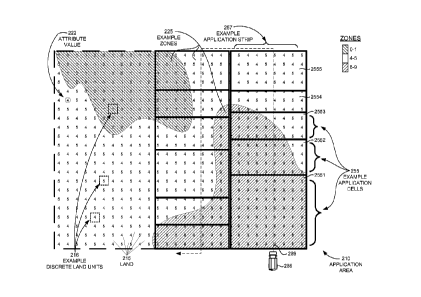
Turning to FIG. 2A, application area 210 is shown logically partitioned into
one or more application cells 255. An application cell 255 represents a
portion of application
area 210 that will receive a certain product of agrochemical. Each application
cell 255
encompasses at least part of a zone 225.
Application cell 255 dimensions can vary based on fertilizer-application
parameters 130, including equipment parameters 132 and user preferences, the
size of
application area 210, and the locations of zones 255. For example, in one
embodiment, the
width of application cells 255 is based on equipment parameters specifying the
physical reach
or coverage area of the fertilizer applicator to be used to apply fertilizer.
In this embodiment,
the dimensions of application cells 255 may be uniform for all application
cells in the
application area 210, or only one dimension, such as the width of application
cells 255, may
be uniform for all application cells. In the embodiment shown in FIG. 2A, only
the width of
the application cells 255 is a fixed dimension, based on physical limitations
of the fertilizer
applicator; the length of each application cell 255 varies based on the
locations of zones 225.
For example, application cells 2551 through 2555, shown on the left side of
application-area
210, each encompass land of a different proportion of zones 225. Application
cell 2551 and
2555 each encompass only land of a single zone 225. Application cells 2552,
2553, and 2554
encompass different proportions of different zones 225. One reason for varying
cell length
based on zones, as will be further described in connection to FIG. 4, is that
the product of
fertilizer determined to be applied for an application cell is based in part
on the zones falling
within the application cell.
In some embodiments, a row of partitioned application cells 255 of uniform
width comprises an application strip 257. An application strip 257 represents
an area of land
covered by a single pass of a fertilizer applicator, such as fertilizer
applicator 288. By way
of example, applying fertilizer to an application area may be accomplished by
a series of
back-and-forth passes over the application area, to ensure the entire
application area receives
fertilizer. This is similar to mowing grass in a yard, where a lawnmower mows
a series of
adjacent paths back and forth over the yard. The width of grass cut by the
mower, for each
back-and-forth pass, is fixed and depends on the radius of the lawn-mower
blade. Similarly,
CA 02813223 2013-03-28
WO 2012/044833 PCT/US2011/054031
- 22 -
in the embodiment shown in HG. 2A, the width of application strip 257, and
therefore the
application cells 255 within application strip 257, is a uniform width, which
is determined
based on the physical limitations of fertilizer applicator 288. Accordingly,
fertilizer
applicator 288 can therefore apply fertilizer to application area 210 by
following a back-and-
forth path 289 over application area 210, with each pass defining an
application strip 257 of
one or more application cells 255. In other embodiments, application cells 255
can exist
independently of an application strip, depending on the applicator technology
to be used for
applying fertilizer.
FIG. 2B depicts another embodiment of attribute zones for the same
application area shown in FIG. 2A. FIG. 2B shows the same application area
210, made up
of the same plurality of discrete land units 216, each having the same
associated attribute
values 222. But the boundaries of zones 226 shown in FIG. 2B are defined by
the outer
perimeters of the discrete land units 216 within each zone. In this
embodiment, zones 226 are
delineated by merging together substantially contiguous discrete land units
216 that have
similar associated attribute values 222. FIG. 2B is provided to convey that
regardless of how
the boundaries of the attribute zones are determined, attribute zones include
areas of land 215
having substantially similar attribute values 222 or attribute values 222
belonging to the same
attribute classification.
FIG. 2C depicts an application area 210, which includes example location
points 217. Location points 217 are similar to discrete land units 216, in
that each location
point 217 has an associated attribute value 222 corresponding to a degree of
expression of an
attribute at that location point. Location points 217 may represent locations
in an application
area corresponding to measurements of an attribute, such as soil pH-level
measurements,
vegetation, soil structure, residue cover, depth to impermeable layer, or
other attributes.
These locations may be uniformly spatially distributed or located wherever
attribute data,
such as field measurements of attributes, are available. In some embodiments,
location points
217 may be more densely located around areas where an attribute has a greater
variance and
may be more spread apart in areas where the attribute varies less. As shown in
FIG. 2C,
example zones 227 comprise an area of land 215 in application area 210 that
has similar
attribute values. In this embodiment, a zone 227 encompasses substantially
adjacently
located location points 217 associated with substantially similar attribute
values 222. In
another embodiment, zones 227 might include substantially adjacently located
location points
CA 02813223 2013-03-28
WO 2012/044833 PCT/US2011/054031
- 23 -
217 associated with attribute values 222 of the same attribute class, such as
"acid" or
"alkaline."
FIG. 2D shows one embodiment having an application area 210 made up of a
plurality of discrete land units 216. The application area 210 of FIG. 2D also
includes a
drainage basin 212. In this embodiment, each discrete land unit 216 has an
associated
attribute value 223, which may be an index value that corresponds to an index
that represents
degrees of expression of an attribute. FIG. 2D depicts an example Topographic
Wetness
Index (TWI). Index legend 290 shows TWI values grouped by index
classifications ranging
from index values less than 10.4, correspond to an "extremely dry" class, to
index values
greater than 19.0 corresponding to an "extremely wet" class. Application area
210 also
includes four zones 225; each zone includes discrete land units with
associated index-values
of the same index classification. Specifically, zone 2251 and zone 2254 are
made of discrete
land units 216 with associated attribute values 223 corresponding to dry
classes of the TWI
(i.e., index values less than 13.8); zone 2252 includes discrete land units
216 having
associated attribute values 223 corresponding to the moderate class; and zone
2253 is made
up of discrete land units 216 with associated attribute values 223
corresponding to the wet
classes of the TWI. Zone 2253 may be expected to include land having wetter
TWI values
because zone 2253 surrounds drainage basin 212. In the embodiment shown in
FIG. 2D,
zones 2251, 2252, 2253, and 2254 are delineated based on having attribute-
values belonging
to the same attribute or index classification, rather than attribute values
that are substantially
similar to each other. Similarly, in an embodiment using attribute values that
are not index
values, zones may be delineated to include attribute values belonging to the
same
classification, rather than attribute values that are substantially similar to
each other.
In some embodiments, a set of attribute values corresponding to a plurality of
discrete land units 216 (or location points) located in an application area
210 is characterized
or represented as an attribute grid, with each point on the grid corresponding
to a location of a
discrete land unit or location point having an associated attribute value.
Likewise, in some
embodiments a set of index values corresponding to a plurality of discrete
land units 216 (or
location points) located in an application area 210 can be characterized and
represented as an
index grid, with each point on the grid corresponding to a location of a
discrete land unit or
location point having an associated index value.
FIG. 2E illustrates two similar views of an application area 210. Both views
show the same three example application strips superimposed over application
area 210:
CA 02813223 2013-03-28
WO 2012/044833 PCT/US2011/054031
- 24 -
application strip 260, which is made up of application cells 255, and
application strips 261
and 262. For clarity, only three example application strips are shown in
application area 210;
although typically application cells or strips will cover the entire
application area 210, it is
not a requirement to do so. The right-hand view also depicts wetness-index
values within the
application strips. The wetness-index values are omitted on the left-hand
view, for clarity.
FIG. 2E also shows a fertilizer-application legend 295, which indicates a
fertilizer product to
be applied to application strips or cells shown in FIG. 2E, and an index-
legend 291, which
provides a visual representation of index values for the wetness attribute.
Application strip 260 represents a variable-product fertilizer application
consistent with an embodiment of the invention. Application strip 260 is made
up of a
plurality of uniformly sized application cells 255. In the embodiment shown in
FIG. 2E,
each application cell has a uniform dimension. Each application cell 255 of
application strip
260 has been evaluated to determine an appropriate product of fertilizer to be
applied to the
cell, based on wetness index values associated with the discrete land units or
location points
(not shown) enclosed by each application cell 255.
For example, according to fertilizer-application legend 295, application cell
281 is coded for receiving a conventional fertilizer type. A conventional
fertilizer type might
be applied to an application cell that encompassed land having drier TWI
values because the
fertilizer would be less susceptible to leaching, evaporation, or
environmental loss
mechanisms, than it would if it were applied to land having wetter TWI values.
Indeed, the
right-hand view of application cell 281 shows that the land encompassed by
application cell
281 includes attribute values corresponding to the drier side of index-legend
291. Similarly,
application cell 282, which encompasses land with attribute values
corresponding to the
wetter side of index legend 291, is coded for receiving an enhanced fertilizer
type. As
previously described, an enhanced fertilizer type may be less susceptible to
environmental
loss mechanisms and is thus appropriate for application to areas having wetter
TWI values.
Application cell 283, which encompasses land with both dry and wet TWI values,
is coded
for receiving a mixture of enhanced and conventional fertilizer types. As used
herein the
term coded, as in "application cell 281 is coded to receive a conventional
fertilizer type" is
intended to mean that a particular fertilizer type is associated with an
application cell.
In contrast to application strip 260, application strips 261 and 262 are shown
designated for receiving a non-variable or single fertilizer source. These
strips may also
receive a fixed application rate. In other words, each strip receives only one
fertilizer type, at
CA 02813223 2013-03-28
WO 2012/044833 PCT/US2011/054031
- 25 -
a given fixed-application rate. Strips 261 and 262 are representative of the
prior art of
fertilizer application technology. Despite encompassing land with varying
attribute values,
strip 261 receives only an enhanced-type fertilizer and strip 262 receives
only conventional-
type fertilizer. As a result, areas having wetter TWI values within strip 262,
may lead to
greater loss of the conventional fertilizer by leaching or by other
environmental loss
mechanisms; similarly areas having drier TWI values within strip 261 may not
require the
more costly enhanced efficiency fertilizer.
Turning now to FIG. 3, an exemplary embodiment is provided showing an
overview of a process of facilitating fertilizer application on an application
area 310. For
purposes of explanation, the process, which is referenced generally by the
numeral 300, is
shown broken down into 6 stages. Each stage of process 300 represents a
different step or
series of steps performed, and thereby provides a visual reference of what
transpires, for one
embodiment.
At a stage 1, fertilizer application area 310 is shown with land
characteristics
312. In the example of FIG. 3, land characteristics 312 represent antecedent
soil moisture,
which may be characterized as attribute values representing TWI. Stage 1 only
shows one
example land characteristic 312 for clarity, but application area 310 can have
multiple land
characteristics, and it is contemplated that the example process of FIG. 3 can
be performed on
other attributes of application area 310. Furthermore in some embodiments,
more than one
characteristic or combinations of characteristics such as slope and depth to
impermeability
may be used to determine attribute values that are then used to delineate
attribute zones.
As previously explained, in some embodiments, an application area such as
application area 310 may be considered to be made up of a plurality of
discrete land units, or
may include a plurality of location points, with each discrete land unit or
location point
associated with a location, which can be a geographically referenced location
or a relative
location, and an attribute value, which represents a degree of expression of
an attribute or
characteristic at that location in an application area. At a stage 2,
attribute values have been
determined for a plurality of discrete land units within application area 310.
In the
embodiment shown, a set of determined attribute values are represented as an
attribute grid
316, with each square in the grid corresponding to a location of a discrete
land unit with an
associated attribute value.
Once attribute values are determined, zones of land with similar attribute
values are delineated. A stage 3 depicts delineated zones including an example
zone 325 in
CA 02813223 2013-03-28
WO 2012/044833 PCT/US2011/054031
- 26 -
application area 310. As will be explained, a zone is delineated based on
attribute values
associated with the discrete land units of application area 310. At a stage 4,
application area
310 is logically partitioned into application cells, such as example
application cell 355. In
this embodiment, the partitioned application cells have a uniform dimension.
In other
embodiments, application cell location and dimensions may vary based on the
locations of
zones. As will be explained, application-cell dimensions may be determined
based on
fertilizer-application parameters and the attribute zones. The process of
logically partitioning
an application area into one or more application cells is sometimes referred
to as "fish-
netting" since each application cell can resemble a single mesh of a fishnet.
Once an application area is logically partitioned into application cells, a
fertilizer product is determined for each application cell. A stage 5 of
process 300 illustrates
logically partitioned application cells, of application area 310, associated
with a fertilizer
product, as indicated by a shading of each application cell. As will be
explained, a fertilizer
product is determined based on attribute values of zones within each
application cell and
based on fertilizer application parameters, in one embodiment. The fertilizer
product may
specify a quantity and type or mixture of fertilizer types to be applied. Each
application cell
is coded for receiving the determined fertilizer product. For example, in the
embodiment
shown, according to legend 395, application cell 381 is to receive a
conventional fertilizer
type; application cell 382 is to receive an enhanced fertilizer type; and
application cell 383 is
to receive a mixed ratio of fertilizer types, for a given rate, respectively.
The determination
of which specific fertilizer types and quantities used for a mixture of
fertilizer types is
discussed in more detail with respect to FIG. 9.
Stage 5 of process 300 also provides an exemplary map 350 of application
area 310 showing each application cell geographically referenced within
application area 310,
and each cell further indicating a fertilizer product to be applied within the
cell. As will be
explained, the output of the fertilizer-product determination step shown in
stage 5, is a set of
fertilizer application-information, which may be visually depicted as a map,
table, schedule,
or association of information. Fertilizer application-information includes
information for a
set of application cells within application area 310, an associated location
for each application
cell, and an associated product of fertilizer for each cell to receive.
Additional information
can be associated with each cell, in some embodiments. Thus, the fertilizer
application-
information can be used to generate a map such as map 350 shown in stage 5 of
process 300.
Such a map may be used to facilitate analysis of fertilizer application
strategies and may be
CA 02813223 2013-03-28
WO 2012/044833 PCT/US2011/054031
- 27 -
combined with other information useful for facilitating analysis or record
keeping. For
example, other embodiments of map 350 might also depict additional information
including
attribute zones, geographic features of the application area, attributes, crop
information such
as past crop yields geographically referenced within the application area,
economic data such
as the incremental cost of fertilizer for each cell or a listing of the total
cost and quantities of
fertilizer needed for the application, regulatory data, and other information.
A stage 6 of process 300 shows generated fertilizer-applicator controller
information 384. In stage 6, the fertilizer-application information determined
in stage 5 is
used to generate applicator-controller information operable to direct a
fertilizer applicator to
apply fertilizer consistent with the determined product for each application
cell.
FIG 3 is intended to provide an overview of one embodiment; additional
stages may exist in other embodiments. For example, the results of stage 5 may
be used for
reporting and record keeping, as we described next in connection to FIGs. 4
and 5, at steps
440 and 540, respectively.
FIG. 4 and FIG. 5 illustratively provide high-level flow diagrams of
embodiments of a method of ultimately applying a variable-product fertilizer
to an
application area. FIGs. 6 through FIG. 9 illustratively provide lower-level
flow diagrams of
embodiments of the steps of the method embodiments depicted in the flow
diagrams of FIG.
4 and FIG. 5. FIGs. 6. through 9 correspond to some of the steps depicted in
FIG. 4 and FIG.
5. The methods depicted in the flow charts of FIGs. 4 through 9 are suitable
for operation in
example operating environment provided in FIG. 1. A computing device, such as
computing
device 164 of FIG. 1 is used to perform or facilitate performing each step.
Turning now to FIG. 4, a flow diagram is provided illustrating an exemplary
method according to one embodiment, shown as 400. The method of flow diagram
400 is
suitable for operation in the exemplary operating environment of FIG. 1. At
step 600,
attribute values are determined, based on application-area information.
Further details of
step 600 are provided in connection to FIG. 6. But as will be explained, an
attribute value is
determined for a plurality of location points or discrete land units in an
application area,
based on application-area information corresponding to the location point or
discrete land
unit. An attribute value thus represents a quantized degree of expression of
an attribute, that
when associated with a location point or discrete land unit, represents the
expression of an
attribute at that location. Application-area information includes information,
which may be
provided by a user or accessed from a data store, relating to one or more sets
of measured or
CA 02813223 2013-03-28
WO 2012/044833 PCT/US2011/054031
- 28 -
determinable values associated with the presence of a characteristic, at
locations in an
application area. For example, a DEM includes information representing
elevation associated
with geographicly referenced locations. Thus, a DEM conesponding to an
application area
will include values representing elevation at a plurality of locations in the
application area.
Therefore, in one embodiment, the DEM information functions as a set of
attribute values.
Accordingly, the attribute values for the elevation attribute may thus be
determined by
determining a portion of a DEM that corresponds to the application area.
An attribute value may express a numerical quantity, such as 735 feet above
sea level, or a category or classification of an attribute, such as "acidic."
An attribute value
also may be determined from another attribute value. For example, attribute
values for slope
may be determined from attribute values for elevation. In some embodiments,
the set of
attribute values may be characterized as a grid, which logically overlays an
application area,
such that the points on the grid correspond to an attribute value at that
location. In some
embodiments, a plurality of attribute sets or grids may be used to determine
fertilizer
application. Therefore in these embodiments, multiple sets or grids of
attribute values,
corresponding to multiple attributes, may be determined at step 600.
The output of step 600 includes application-area information specifying a set
of attribute values, each associated with a location point or discrete land
unit in an application
area. At a step 700, this information is used to delineate attribute zones of
ground, within the
application area, encompassing location points or discrete land units with
similar associated
attribute values. Each location within an application will fall within a zone.
For example, if
a zone for the soil pH-level attribute is delineated to include those discrete
land units having
associated attribute values (i.e., soil pH-levels, in this example)
corresponding to "acid," then
the remaining discrete land units of the application area will fall within a
separate zone
corresponding to "non-acid" or "alkaline and neutral" soil pH-levels. Further
details of step
700 are provided in connection to FIGs. 7A through 7C.
At a step 800, the application area is partitioned into one or more
application
cells. As previously explained, an application cell represents a portion of
land that will
receive a certain product of fertilizer. Further details of partitioning step
800 are provided in
connection to FIG. 8. As will be explained, the dimensions of the partitioned
application
cells are based on fertilizer-application parameters, the locations of
attribute zones, or both.
Fertilizer-application parameters include fertilizer-applicator equipment
parameters that can
determine the width of an application cell based on the reach of the
fertilizer applicator used
CA 02813223 2013-03-28
WO 2012/044833 PCT/US2011/054031
- 29 -
to apply fertilizer. The equipment parameters can also determine a minimum
application cell
length, based on limitations of the fertilizer applicator to change fertilizer
products as it
traverses the application area. In an exemplary embodiment, the width of each
application
cell will be uniform, but the length will vary based on the location of zones
in the application
area. In this embodiment, a row of application cells comprises an application
strip, which
represents one traverse of the application area by a fertilizer applicator. As
will be explained
in connection to FIG. 8, in one embodiment, application cell length may be
determined based
on the locations of zones, in order to minimize variance of zones in an
application cell, as the
cell length increases.
Because every location in an application area will fall within a zone
determined in step 700, each application cell will encompass at least a part
of a zone. As a
consequence, associated with each application cell is zone information about
each zone,
zones, or zone portions enclosed by the application cell. This information
includes the area
of the application cell occupied by a zone or a portion of a zone and the zone
attribute and
attribute values associated with the zone.
At a step 900, a fertilizer product, for application within each application
cell,
is determined. The zone information associated with each application cell may
be used with
fertilizer-application parameters to determine a product of fertilizer to
apply to each
application cell. As
previously explained, a fertilizer product can specify a quantity and
type or mixture of fertilizer types to be applied, as well as a rate, in one
embodiment. The
zone information associated with each application cell, in partitioning step
800, includes
attribute values associated with a zone that can be used to determine a
fertilizer type
appropriate for the zone. For example a zone having attribute values
indicating wetness may
be designated to receive an enhanced-type fertilizer. As
will be explained, in one
embodiment, the fertilizer product determined for an application cell is based
on the area of
the application cell occupied by a zone or a portion of a zone. For example,
in this
embodiment an application cell occupied entirely by a portion of a wet zone,
might be
determined to receive an enhanced-type fertilizer, depending on other
fertilizer application
parameters. But an application cell that encloses multiple zones or portions
of zones might
receive a mixture of fertilizer types, wherein the mixture ratio is
proportional to the area
occupied by each zone or zone portion within the application cell. In another
embodiment,
the attribute values of location points or discrete land units enclosed by an
application cell are
CA 02813223 2013-03-28
WO 2012/044833 PCT/US2011/054031
- 30 -
used to determine a fertilizer product. Each application cell is coded for
receiving a
determined fertilizer product corresponding to that cell.
The output of step 900 is fertilizer-application information. In
one
embodiment, this comprises a set of application cells, each associated with
information
indicating cell location in an application area and a product of fertilizer to
be applied to the
cell. In one embodiment, the application cells are associated with
geographically referenced
location information. Additional information relating to attribute-values and
information
from the fertilizer-application parameters may also be associated with each
cell. Further
details of step 900 are provided in connection to FIG. 9.
At a step 480, application controller information for a fertilizer applicator
is
generated. Specifically, the fertilizer-application information outputted from
step 900 is used
to generate computer instructions for operating a fertilizer-applicator
controller to control
fertilizer application by a fertilizer applicator consistent with the
fertilizer product determined
in step 900. Fertilizer-application parameters include information relating to
a fertilizer
applicator or a controller used by the applicator, for example, a model
number, controller
identification, or similar information usable for determining a controller and
generating
instructions executable by the controller for applying fertilizer. In one
embodiment, this
includes a table or library of instructions for controlling application by the
fertilizer
applicator.
In one embodiment, fertilizer-application information is used to create a
shape
file, which graphically indicates the locations of application cells in an
application area and
the determined fertilizer product for each cell. The determined fertilizer
product may be
indicated by color, shading, or a similar visual reference, as shown in stage
5 of FIG. 3 or the
left-hand side of FIG. 2E, for example. Using a library of instructions for a
controller, the
shape file is then converted to an appropriate file format for execution by
the controller.
The fertilizer application is location dependent; each cell is associated with
a
location in the application area. Accordingly, in one embodiment, controller
instructions
include a fertilizer product to apply for a given application cell and an
associated location
information, which may define the boundaries (or merely the cell length) of
that application
cell. In an embodiment having uniformly sized application cells, controller
instructions may
correspond to a listing of fertilizer products such that a controller applies
a product specified
on the list for a certain duration or distance. In one embodiment, location
information may be
present via the fertilizer applicator and the applicator controller may
receive location
CA 02813223 2013-03-28
WO 2012/044833 PCT/US2011/054031
- 31 -
information in real-time (or near real-time) to determine an immediate product
of fertilizer to
apply based on that received location.
Continuing with FIG. 4, at a step 440 the results of step 900, including the
fertilizer-application information, may be stored for record keeping or used
for subsequent
analysis, in one embodiment. Stored information becomes part of a set of
historical
information, over time, which can be used in future fertilizer-application
sessions or analysis,
in some embodiments. Analysis may also be performed using the fertilizer-
application
information from step 900. By way of example, fertilizer application
information may be
used to generate a table or listing of fertilizer application products for
each cell or geographic
map of the application area showing each application cell associated with a
determined
product of fertilizer to be applied to that cell. Fertilizer products to be
applied to each cell
may be indicated by color-coding, shading, text, outlining, or similar means.
In one
embodiment, fertilizer application parameters, such as user-provided
information, date or
time information, regulatory information, fertilizer costs, near-by
geographical features, or
crop-related information is included on the map or automatically placed with
the map into a
report that details recommended variable-product fertilizer (or agrochemical)
application.
This information may, in one embodiment, be stored in a file, viewed, and
printed. In
another embodiment, a user may export a map showing fertilizer application as
a shape file or
similar format, which then can be used as a map layer with other information
such as crop-
yield maps. In another embodiment, a table or geographic map indicating
fertilizer products
for each application cell is generated with information indicating economic
information such
as the cost of fertilizer for each cell or the total fertilizer cost, an
estimated differential crop
yield resulting from applying one determined product vs. another determined
product of
fertilizer for an application cell, expected profit from crops or a cost-
benefit analysis, which
compares the cost of applying a determined product of fertilizer vs. the
estimated crop yield
or profit conesponding to an application of the determined product of
fertilizer, for an
application cell. In other embodiments, additional information may be included
on a
geographic map or table indicating fertilizer products for each application
cell, such as:
attributes of the application area, as shown in the right-hand side of FIG.
2E; historical
information representing past fertilizer applications or past crop yields; an
indication where
user-preference deviates from determined fertilizer products for each
application cell; an
identification of total fertilizer quantities, brands, types, rates, or
mixture ratios; applicator
equipment information; or government regulations. Such additional information
may be
CA 02813223 2013-03-28
WO 2012/044833 PCT/US2011/054031
- 32 -
geographically referenced on the map where appropriate, in some embodiments.
By way of
example, consider an application cell that would otherwise be determined to
require a certain
product of fertilizer, but because of a fertilizer application parameter such
as a government
regulation or user-specified buffer, a different product of fertilizer has
been determined.
Information representing this can be represented on the map, and
geographically referenced
to the application cell or cells to which it applies. In one embodiment, an
asterisk may be
placed on a cell and below the map the asterisk may correspond to information
affecting that
cell' s determined product of fertilizer, such as a message indicating that
the fertilizer product
determined for the cell is affected by a user-designated buffer. Other
combinations of
information, representing fertilizer-application information including the
determined product
of fertilizer, historical information, and application area information, may
be visually
presented on a user interface as a geographically referenced map of an
application area
suitable for use by a grower, fertilizer distributor, or user to facilitate
determining or
analyzing a fertilizer application strategy.
FIG. 5 is a flow diagram illustrating an exemplary method according to one
embodiment, shown as 500. The method of flow diagram 500 is suitable for
operation in the
exemplary operating environment of FIG. 1. At step 601, attribute values are
determined,
based on application-area information.
Further details of step 601 are provided in
connection to FIG. 6. But as will be explained, an attribute value is
determined for a plurality
of location points or discrete land units in an application area, based on
application-area
information corresponding to the location point or discrete land unit. In one
embodiment, the
attribute values are index values. An index value represents a quantized
degree of expression
of a characteristic or attribute scaled or applied to an index that when
associated with a
location point or discrete land unit, represents the expression of a
characteristic or attribute at
that location according to an index of characteristic or attribute values.
Application-area
information includes information, which may be provided by a user or accessed
from a data
store, relating to one or more sets of measured or determinable values
associated with the
presence of a characteristic, at locations in an application area. For
example, a DEM includes
information representing elevation associated with geographic locations. Thus,
a DEM
corresponding to an application area will include values representing
elevation at a plurality
of locations in the application area, and may thus constitute a set of
attribute-values for
elevation. In one embodiment, as will be explained, this DEM information may
be used to
determine a Topographic Wetness Index for the application area.
CA 02813223 2013-03-28
WO 2012/044833 PCT/US2011/054031
- 33 -
An index value, like an attribute value, may express a numerical quantity,
such
as a TWI of 18.7, or a category or classification of a characteristic or
attribute, such as
"extremely wet." An index value also may be determined from another index
value or an
attribute value. For example, index values for wetness may be determined from
attribute
values for elevation, as will be explained in connection to FIG. 6. A set of
index values
represents an attribute or characteristic. In some embodiments, the set of
index values may
be characterized as an index grid, which logically overlays an application
area, such that the
points on the grid correspond to an index value at that location. Such a grid
of index values
may be represented as a raster, in some embodiments. In some embodiments, a
plurality of
indices or grids may be used to determine fertilizer application. Therefore in
these
embodiments, multiple indices or grids of index values, corresponding to
multiple
characteristics or attributes, may be determined at step 601.
The output of step 601 includes application-area information specifying a set
of attribute values or index values, each associated with a location point or
discrete land unit
in an application area. At a step 701, this information is used to delineate
zones of ground,
within the application area, encompassing location points or discrete land
units with similar
associated attribute values. Each location within an application will fall
within a zone. For
example, if a zone for the wetness index is delineated to include those
discrete land units
having associated wetness-index values less than or equal to 14, then the
remaining discrete
land units of the application area will fall within a separate zone having
wetness-index values
greater than 14. Further details of step 701 are provided in connection to
FIGs. 7A through
7C.
At a step 801, one or more nonoverlapping application cells, within the
application area, are defined. In one embodiment, the application area is
partitioned into one
or more application cells. In another embodiment, an application-cell
boundaries are
determined based on the delineated zones of step 701 and relevant fertilizer
application
parameters, as will be explained. In this embodiment, application cells are
geographically
positioned within the application area, based on the location of zones,
dimensions of the
application area, or fertilizer-application parameters.
As previously explained, an application cell represents a portion of land that
will receive a certain product of fertilizer. Further details of step 801 are
provided in
connection to FIG. 8. As will be explained, in various embodiments, the
dimensions of the
defined application cells are based on fertilizer-application parameters,
which can include
CA 02813223 2013-03-28
WO 2012/044833 PCT/US2011/054031
- 34 -
equipment parameters or user-defined cell dimensions, the locations of
attribute zones, or a
combination of fertilizer-application parameters and the locations of
attribute zones.
Fertilizer-application parameters include fertilizer-applicator equipment
parameters that can
determine the width of an application cell based, for example, on the reach or
coverage area
of the fertilizer applicator used to apply fertilizer. The equipment
parameters can also
determine a minimum application-cell length, based on limitations of the
fertilizer applicator
to alter fertilizer products as it traverses the application area. In an
exemplary embodiment,
the width of each application cell will be uniform, but the length will vary
based on the
location of zones in the application area. In this embodiment, a row of
application cells
comprises an application strip, which represents one traverse of the
application area by a
fertilizer applicator. As will be explained in connection to FIG. 8, in one
embodiment,
application cell length may be determined based on the locations of zones, in
order to
minimize variance of zones in an application cell, as the cell length
increases.
Because every location in an application area will fall within a zone
determined in step 701, each application cell will encompass at least a part
of a zone. As a
consequence, associated with each application cell is zone information about
each zone,
zones, or zone portions enclosed by the application cell. This information
includes the area
of the application cell occupied by a zone or a portion of a zone and the zone
attributes,
indices, and index values associated with the zone.
At a step 901, a schedule specifying fertilizer-application information for
each
application cell is determined. The schedule can include, in one embodiment,
information
specifying for each application cell, a product of fertilizer to apply, or a
quantity or rate and
fertilizer type or types, and a mixture ratio, if a mixture of fertilizer
types is to be applied.
The zone information associated with each application cell may be used with
fertilizer-
application parameters to determine the fertilizer-schedule information of
each application
cell. The zone information associated with each application cell, in step 801,
includes
attribute or index values associated with a zone that can be used to determine
a fertilizer type
appropriate for the zone. For example a zone having attribute or index values
indicating
wetness may be designated to receive an enhanced-type fertilizer. As will be
explained, in
one embodiment, a fertilizer product determined for an application cell is
based on the area of
the application cell occupied by a zone or a portion of a zone. For example,
in this
embodiment an application cell occupied entirely by a portion of a wet zone,
might be
determined to receive an enhanced-type fertilizer, depending on other
fertilizer-application
CA 02813223 2013-03-28
WO 2012/044833 PCT/US2011/054031
- 35 -
parameters. But an application cell that encloses multiple zones or portions
of zones might
receive a mixture of fertilizer types, wherein the mixture ratio is
proportional to the area
occupied by each zone or zone portion within the application cell. In another
embodiment,
the attribute or index values of location points or discrete land units
enclosed by an
application cell are used to determine a fertilizer-application schedule
indicating a determined
fertilizer product for each application cell.
The output of step 901 includes fertilizer-application information. In one
embodiment, this comprises a schedule of information relating to a set of
application cells,
with each cell associated with information indicating location in an
application area and a
product of fertilizer to be applied to the cell. Additional information
relating to attribute-
values and information from the fertilizer-application parameters may also be
associated with
each cell. Further details of step 901 are provided in connection to FIG. 9.
At a step 580, application controller information for a fertilizer applicator
is
generated. Specifically, the fertilizer-application information outputted from
step 901 is used
to generate computer instructions for operating a fertilizer-applicator
controller to direct
fertilizer application by a fertilizer applicator consistent with the
fertilizer schedule
determined in step 901. Fertilizer-application parameters can include
information relating to
a fertilizer applicator or a controller used by the applicator, for example, a
model number,
controller identification, or similar information usable for determining a
controller and
generating instructions executable by the controller for applying fertilizer.
In one
embodiment, this includes a table or library of instructions for controlling
application by the
fertilizer applicator.
In one embodiment, fertilizer-application information is used to create a
shape
file, which graphically indicates the locations of application cells in an
application area and
the determined fertilizer product for each cell. The determined fertilizer
product may be
indicated by color, shading, or similar visual reference, as shown in Stage 5
of FIG. 3 or the
left-hand side of FIG. 2E, for example. Using a library of instructions for a
controller, the
shape file is then converted to an appropriate file format for execution by
the controller.
The fertilizer (or agrochemical) application is location dependent; each cell
is
associated with a location in the application area. Accordingly, in one
embodiment,
controller instructions include an product of fertilizer to apply for a given
application cell and
an associated location information, which may define the boundaries (or merely
the cell
length) of that application cell. In an embodiment having uniformly sized
application cells,
CA 02813223 2013-03-28
WO 2012/044833 PCT/US2011/054031
- 36 -
controller instructions may correspond to a listing of fertilizer products
such that a controller
applies a product specified on the list for a certain duration or distance. In
one embodiment,
location information may be present via the fertilizer applicator and the
applicator controller
may receive location information in real-time (or near real-time) to determine
an immediate
product of fertilizer to apply based on that received location.
At a step 540 the schedule of step 901, including the fertilizer-application
information, may used for subsequent analysis, in one embodiment. The
fertilizer-application
information may also be stored, and overtime become part of a set of
historical information,
which can be used in future fertilizer application sessions or analysis, in
some embodiments.
Analysis may also be performed using the schedule or other fertilizer
application information
from step 901. By way of example, fertilizer application information may be
used to
generate a table or listing of fertilizer application products for each cell
or geographic map of
the application area showing each application cell associated with a product
of fertilizer to be
applied to that cell. Fertilizer products to be applied to each cell may be
indicated by color-
coding, shading, text, outlining, or similar means. In one embodiment,
fertilizer application
parameters, such as user-provided information, date or time information,
regulatory
information, fertilizer costs, near-by geographical features, or crop-related
information are
included on the map or automatically placed with the map into a report that
details
recommended variable-product fertilizer (or agrochemical) application. This
information
may, in one embodiment, be stored in a file, viewed, and printed. In another
embodiment, a
user may export a map showing fertilizer application as a shape file or
similar format, which
then can be used as a map layer with other information such as crop-yield
maps. In another
embodiment, a table or geographic map indicating fertilizer products for each
application cell
is generated with information indicating economic information such as the cost
of fertilizer
for each cell or the total fertilizer cost, an estimated differential crop-
yield resulting from
applying one determined product vs. another determined product of fertilizer
for an
application cell, expected profit from crops or a cost-benefit analysis, which
compares the
cost of applying a determined product of fertilizer vs. the estimated crop
yield or profit
corresponding to an application of the determined product of fertilizer, for
an application cell.
In other embodiments, additional information may be included on a geographic
map or table
indicating a fertilizer product for each application cell, such as: attributes
or characteristics
of the application area, as shown in the right-hand side of FIG. 2E;
historical information
representing past fertilizer applications or past crop yields; an indication
where user-
CA 02813223 2013-03-28
WO 2012/044833 PCT/US2011/054031
- 37 -
preference deviates from determined fertilizer products for each application
cell; an
identification of total fertilizer quantities, brands, types, rates, or
mixture ratios; applicator
equipment information; or government regulations. Such additional information
may be
geographically referenced on the map where appropriate, in some embodiments.
By way of
example, consider an application cell that would otherwise be determined to
require a certain
product of fertilizer, but because of a fertilizer application parameter such
as a government
regulation or user-specified buffer, a different product of fertilizer has
been determined.
Information representing this can be represented on the map, and
geographically referenced
to the application cell or cells to which it applies. In one embodiment, an
asterisk may be
placed on a cell and below the map the asterisk may correspond to information
affecting that
cells determined product of fertilizer, such as a message indicating that the
fertilizer product
determined for the cell is affected by a user-designated buffer. Other
combinations of
information, representing fertilizer-application information including the
determined product
of fertilizer, historical information, and application area information, may
be visually
presented on a user interface as a geographically referenced map of an
application area
suitable for use by a grower, fertilizer distributor, or user to facilitate
determining or
analyzing a fertilizer application strategy.
Turning now to FIG. 6, a flow diagram is shown illustrating an exemplary
method of determining attribute values or index values, according to an
embodiment, shown
as 600. At a step 610 application area information is received. As explained
previously,
application-area information generally comprises attribute-related information
associated
with location information, which may be geographically-referenced or
relatively-referenced
location information, such as locations based on the boundaries of the
application area, a
common point of reference, or other local locations. Application area
information may be
received directly from a user or from a data store, either locally or online.
Application area
information may be received within a defined input-window, at any time, or as
needed,
including subsequently to determining a grid or set of attribute values or
index values, such as
in cases where attribute values or index values are determined based on other
attribute values
or index values. In one embodiment, a user provides field records,
measurements, lab data,
or similar information directly via a user interface. In another embodiment,
application area
information is received from a data store, where it may be accessed according
to location
information related to the application area. For example, in one embodiment,
application
CA 02813223 2013-03-28
WO 2012/044833 PCT/US2011/054031
- 38 -
area information is accessed from a GIS or similar database, using information
related to the
geographical location of the application area, such as coordinates specifying
its boundaries.
At a step 620, a set or grid of attribute values is determined. Alternatively,
in
one embodiment, a set or grid of index values is determined. Application-area
information
may be received already as a set of attribute-related information associated
with location
points or discrete land units in the application area. For example,
application-area
information may be received as a heatmap, raster, table, or similar format
that associates
values of an expression of a characteristic to locations in an application
area. Thus the
received application-area information already may be in a format suitable for
use as a grid or
set of attribute values. In some embodiments, it is not necessary to determine
a grid of
attribute values or index values as described in connection to step 620.
Rather in some
embodiments, the application area information, received in step 610, already
specifies one or
more sets of attribute values or index values sufficient for delineating
zones. In other
embodiments, a set or sets of attribute values may be further processed to
determine other
attribute values used for delineating attribute zones. For example, a set of
attribute values
corresponding to elevation and a set of attribute values corresponding to
residue cover may
be used together to determine a set of attribute values representing TWI for
the application
area.
In some embodiments, attribute values may be processed to be become index-
values. In some embodiments, attribute values or index values may be
determined from this
received set of attribute-related information associated with location points
or discrete land
units in the application area. By way of example, received DEM information for
an
application area includes elevation information associated with the locations
discrete land
units, specified by the resolution of the DEM. This information is suitable
for use as a set or
grid of attributes for elevation, or it may be subsequently processed for
determining wetness-
index values associated with each discrete land unit. In another example,
received field data,
such as measurements of application area characteristics, may already include
location
information associated with each measurement value, which may be used as an
attribute or
index value.
Alternatively, in some embodiments a grid or set of attribute values, or index
values, for an application area must be determined by identifying discrete
land units and their
locations or identifying location points, determining a value representing an
attribute at the
location point or location of the discrete land unit, and associating that
attribute value with
CA 02813223 2013-03-28
WO 2012/044833 PCT/US2011/054031
- 39 -
the location point or discrete land unit. A discrete land unit size may be
specified by a user or
by the application-area information. For example DEM information includes a
resolution,
which is indicative of the size of discrete land units having the elevation
attribute. For
example, a 10 m DEM has an elevation value associated with each 10 meter-
square area. If
multiple attribute values are present in a discrete land unit, an average,
median, or otherwise
representative value may be used as the attribute value. Alternatively, the
discrete land unit
may be subdivided into smaller discrete land units, such that each discrete
land unit is
associated with one of the attribute values.
In one embodiment, an attribute or index to be used for determining a set of
attribute values or index values may be specified by fertilizer-application
parameters. In one
embodiment, fertilizer-application parameters include an attribute preference
received from a
user. The user may select the attribute or index via a user interface or may
indicate a
preference or selection related to fertilizer application that inherently
specifies an attribute.
In one embodiment, a previously selected or previously considered attribute is
used as a
default selection. In one embodiment, the user may be prompted to make a
selection, or a
user may be presented with previously considered attributes. In one
embodiment, an attribute
is determined based on available application-area information. For example,
where
application area information only corresponds to acidity or alkalinity, a soil
pH-level attribute
would be used. In another embodiment, fertilizer-application parameters
relating to available
fertilizer inventory, fertilizer costs, or regulations are used to determine
an attribute. In the
case where multiple attributes are possible, a user may be presented with a
list to select from,
via a user interface. Alternatively, attributes may correspond to a priority,
ranking preferred
attributes.
FIG. 6 illustratively provides an exemplary embodiment for determining a grid
of attribute values, or index values, in step 620. In this embodiment, a
Topographic Wetness
Index grid is determined. At a step 625 DEM information corresponding to an
application
area is determined. The DEM information may be part of a library or GIS
database, in one
embodiment, and accessible via a data store. A user specifies the DEM
information that
corresponds to the application area via a user interface, in one embodiment,
by defining a
boundary of an area in the DEM corresponding to the application area. In one
variation of
this embodiment, a user interface may be designed or provided using ArcMap.
The interface
can permit a user to view an aerial depiction of land, such as a satellite or
aerial image, that
includes the application area, and enable the user to draw a boundary around
the application
CA 02813223 2013-03-28
WO 2012/044833 PCT/US2011/054031
- 40 -
area. Upon completing drawing a boundary around the application area, the user
can click a
button to automatically determine DEM information corresponding to the area
enclosed by
the user-defined boundary. A further variation of this embodiment adds a
buffer area around
the user-defined boundary. In another embodiment, a user may provide
coordinates of the
boundary of an application area or specify an application area with known
coordinates usable
for identifying corresponding DEM information. In one embodiment, DEM
information
corresponding to an application area is determined automatically from
available application
area information. In
one embodiment, a user is also prompted to specify the type or
resolution of DEM information to be used for the DEM. The DEM information
provides
elevation values for discrete areas of ground. For example, a 10-meter DEM
provides an
elevation for each 10-meter-square area of ground. Thus each 10-meter-square
area of
ground represents a discrete land unit, and the elevation represents an
associated attribute
value.
At step 635, step 645, and step 655, processing is performed on the DEM
information to determine flow direction grid, a flow accumulation grid, and a
slope grid,
respectively. A flow direction grid created in step 635 is a raster dataset
representing flow
direction from each discrete land unit to its steepest downslope neighbor. The
output of step
635 is an integer raster with values ranging from 1 to 255. At step 645 a flow
accumulation
grid is created. A flow direction grid is a raster dataset representing
accumulated flow to
each discrete land unit, as determined by accumulating the weight for all
discrete land units
that flow into each downslope discrete land unit. Discrete land units having
undefined flow
direction may only receive flow; they will not contribute to any downstream
flow. At step
655 a slope grid is created, which identifies the rate of maximum change in z-
value for each
discrete land unit.
A step 660 determines whether to use additional application-area variables for
determining TWI values. These include variables for predicting relative
spatial variability in
wetness such as vegetation, soil structure, depth to impermeable layer, and
residue cover.
The decision to use these variables may be specified by the fertilizer
application parameters,
or may be made automatically when application-area information corresponding
to these
variables is available. At a step 665, the additional variables are
determined. In one
embodiment, these variables include an attribute value associated with a
location point or
discrete land unit and may be determined as described in connection to step
620, above.
CA 02813223 2013-03-28
WO 2012/044833 PCT/US2011/054031
- 41 -
At a step 670, a TW1 grid is created. TW1 is used to quantify hydrological
processes. For example, as previously explained, TWI can provide a likelihood
of
accumulation of water within a region. In one embodiment, TWI combines local
upslope
contributing area and slope information and is defined as:
TABLE 2
ln(As/tanfl)
where As is the flow accumulation or upslope contributing area per unit grid-
cell width (m2/m) and tanfi is the land slope in degrees.
In one embodiment, the processes corresponding to steps 625, 635, 645, 655,
and 670, discussed above, may be carried out using computer-readable
instructions written in
Visual Basic or Python and using a library of GIS software functions such as
ArcG1S
developed and released by Environmental Systems Research Institute (ESRI) of
Redlands,
CA. Thus for example, at step 625, a DEM area corresponding to an application
area is
determined from a user-defined boundary of the application area according to
the following
instructions:
TABLE 3
# Process: Clip...
gp.Clip_management(ra,vdata, Rectanglea, clipdata, rasclata)
InFlowD = "NORMAL"
InType = "DEGREE"
At step 635, a flow direction grid is created according to the following
instructions:
TABLE 4
#Process: FlowDirection
gp.FlowDirection_sa(clipdata, flowd, InFlowD)
At step 645, a flow accumulation grid is created according to the following
instructions:
TABLE 5
# Process: Flow Accumulation
gp.FlowAccumulation_sa(flowd, flowa)
At step 655, a slope grid is created according to the following instructions:
CA 02813223 2013-03-28
WO 2012/044833
PCT/US2011/054031
- 42 -
TABLE 6
# Process: Slope
gp.Slope_sa(clipdata, fslope, InType)
RadDeg = "57.296"
#Process Slope and multiple it by a conversion unit
gp.Divide_sa(fslope, RadDeg, fslopedeg)
#Process Contributing slope
gp.Con_sa(flowa, 100, conta)
#Constant values
Input_raster_or_constant_value_2 = "100"
Input_raster_or_consiant_value_plus = "1"
# Process Contributing Area
gp.Plus_sa(flowa, Input_raster_or_constant_value_plus, flowa2)
gp.Times_sa(flowa2, Input_raster_or_constant_value_2, conta)
And at step 670, a TWI grid is created according to the following
instructions:
TABLE 7
# Topographic Wetness Index
oTan = outtan"
dTan = "than"
topowi = "wetindex"
Inttopovvi = "Int_tvvi"
twiclass = " wi_class"
gridpoly = " wipoly.shp"
tabclass = " UPDATED_TABLE"
recltab = " wirec"
# Process Tangent
gp.Tan_sa(fslopedeg, oTan)
# Process Divides
gp.Divide_sa(conta, oTan, dTan)
# Process TWI
gp.Ln_sa(dTan, topowi)
# Processing Topographic Wetness Index to an Integer"
gp.Int_sa(topowi, Inttopowi)
# Reclass data
gp.ReclassByASCIIFile_sa(Inttopowi, rec_2_txt, recltab, "DATA")
CA 02813223 2013-03-28
WO 2012/044833 PCT/US2011/054031
- 43 -
FIGs. 7A, 7B, and 7C illustratively provide exemplary methods for delineating
zones according to embodiments of the present invention, and are shown as 710,
720. and
730 respectively. Generally as shown in methods 710, 720, and 730, attribute
zones or index
zones are delineated based on a received set of attribute values or index
values, which in
some embodiments may be received as a grid of attribute values or index
values. Although
the steps of methods 710, 720, and 730 may illustratively depict using
attribute values or
index values, it is understood that, at least in methods 710, 720. and 730, an
attribute value
may be used in place of an index value, and vice versa. This is not to say
that an attribute
value equals an index value, which is not necessarily true. Similarly,
attribute values or index
values may be received in the form of a grid or a set of values, including a
table of values and
a raster data set. Thus, for example, steps 712, 722, and 732 may receive
attribute values or
index values, as either a set of values or as a grid.
In some embodiments, multiple iterations of methods 710, 720, or 730 will be
performed resulting in a set of attribute zones or index zones, with each
member of the set
corresponding to all of the zones for a particular attribute or index, such as
all of the TWI
zones or all of the zones for soil-pH level.
Turning now to FIG. 7A, at a step 712, a grid of attribute values is received.
Attribute values may be received from a step of determining attribute values
or index values,
such as step 600 of FIG. 4 or step 601 of FIG. 5; received from a user via a
user interface. or
received from a data store of application-area information. In one embodiment,
the grid of
attribute values received in step 712 comprises a raster dataset. At a step
714, polygon shape
files are created based on the grid of attribute values. A polygon shape file
is a graphic
representation of an attribute value associated with a discrete land unit;
each shape file has a
polygon value corresponding to an attribute value. By way of example, a set of
attribute
values for an application area may be graphically represented as a
geographically referenced
raster-image, heat map, or similar visual depiction of discrete land units
that are color coded,
shaded, or marked to represent attribute values. This graphical representation
may be
converted to an image format, in one embodiment, such that information is
stored as a
bitmap-type image. The output of step 714 thus comprises a set of polygon
shape files, with
each shape file having a polygon value corresponding to the received set of
attribute values.
At a step 716, adjacently positioned, substantially similar shape files are
merged together to form an attribute zone. In one embodiment, polygon values
of adjacent
shape files are compared, and where adjacent shape files are found to be
identical or within a
CA 02813223 2013-03-28
WO 2012/044833 PCT/US2011/054031
- 44 -
certain threshold indicating substantial similarity or classification, the
shape files are merged.
In one embodiment, this threshold is determined from a fertilizer-application
parameter,
which might include threshold information received from a user. In another
embodiment, a
threshold is determined based on the range of values of the received index
values or attribute
values; for example, a threshold may be determined based on a standard
deviation of index
values or attribute values. In still another embodiment, image processing is
performed on
adjacent shape files to identify and merge adjacent shape files having similar
color or
shading. The output of step 716 includes one or more delineated zones
representing areas of
similar characteristics; embodiments can include one or more shape files
corresponding to
each zone, or a data structure of zone-boundary locations and associated
attribute values or a
classification of attributes of each zone.
In one embodiment, the processes conesponding to steps 714 and 716 may be
carried out using computer-readable instructions written in Visual Basic or
Python and using
a library of GIS software functions. Accordingly, at step 714 , polygon shape
files are
created from a grid of attribute values according to the following
instructions:
TABLE 8
# Convert the TWI Raster data to a polygon shapefile
rasierfld = "VALUE"
gp.RasterToPolygon_conversion(recltab, gridpoly, "SIMPLIFY",
msterfld)
wipoly_Dissolve_shp = "wipolydis.shp"
wipoly_shp = "wipolydis.shp"
And at step 716, adjacent shape files representing substantially similar
characteristics are merged together to form one or more zones according to the
following
instructions:
TABLE 9
gp.Dissolve_management(wipoly_shp, wipoly_Dissolve_shp,
"GRIDCODE", ", "MULTIPART")
Turning to FIG. 7B, another method for delineating zones according to
embodiments of the present invention is illustratively provided. At a step
722, attribute
values are received. Attribute values may be received as a set or grid of
attribute values from
a step of determining attribute values or index values, such as step 600 of
FIG. 4 or step 601
CA 02813223 2013-03-28
WO 2012/044833 PCT/US2011/054031
- 45 -
of FIG. 5; received from a user via a user interface, or received from a data
store of
application-area information. At a step 724, discrete land units associated
with the received
attribute values are identified. Processing for delineating a zone is
performed on discrete
land units, in the embodiment provided by FIG. 7B, thus step 724 identifies
the discrete land
units associated with each received attribute value. At a step 726, adjacently
positioned
discrete land units associated with identical attribute values are merged to
form subzones.
The output of step 726 includes one or more subzones made up of discrete land
units that
have the same attribute value. Thus each created subzone becomes associated
with the
attribute value of its component discrete land units. In one embodiment, the
subzones
determined in step 726 are used as delineated zones.
At a step 728, adjacently positioned subzones that have substantially similar
attribute values are merged together to form a delineated attribute zone. A
threshold may be
used to indicate substantial similarity. In one embodiment, this threshold is
determined from
a fertilizer-application parameter, which might include threshold information
received from a
user. In another embodiment, a threshold is determined based on the range of
values of the
received index values or attribute values, for example, a threshold may be
determined based
on a standard deviation of index values or attribute values. In another
embodiment, a cluster
analysis of values of subzones may be performed to determine zones based on
clusters of
subzones.
In another embodiment, subzones associated with attribute values
corresponding to the same attribute classification are merged together to form
a delineated
attribute zone. By way of example, for the soil pH-level attribute, subzones
associated with
pH-levels less than 7 might be merged into a zone corresponding to "acidic,"
since the
attribute values associated with each subzone correspond to the same attribute
classification,
(i.e., "acidic"). This embodiment contemplates a scenario where substantially
similar
attribute values or index values represent different attribute or index
classifications, and thus
are not included in the same zone. By way of example using the pH-level
attribute again,
attribute values of 6.9 and 7.1 might be considered substantially similar, in
that both values
are close to a neutral pH-level, and therefore according to the previously
described
embodiment, their associated discrete land units (or location points) would be
included in the
same zone. But because an attribute value of 6.9 is considered acidic and an
attribute value
of 7.1 is considered basic or alkaline, under this embodiment, the discrete
land units
associated with the two attribute values might fall into different zones. This
embodiment also
CA 02813223 2013-03-28
WO 2012/044833 PCT/US2011/054031
- 46 -
contemplates a scenario where zones are formed based on attribute values of
discrete land
units (or location points) falling into ranges of attribute values. For
example, in one
embodiment, a TWI can be divided into 7 ranges: (1) less than 10.4, (2) 10.4-
12.1, (3) 12.1-
13.8, (4) 13.8-15.6, (5) 15.6-17.3. (6) 17.3-19, and (7) greater than 19,
conesponding to the
following classifications: extremely dry, very dry, dry, moderate, wet, very
wet, and
extremely wet, respectively.
Turning to FIG. 7C, another method for delineating zones according to
embodiments of the present invention is illustratively provided. At a step
732, attribute
values are received. Attribute values, which may be in the form of index
values, may be
received as a set or grid of attribute values from a step of determining
attribute values, such
as step 601 of FIG. 5; received from a user via a user interface, or received
from a data store
of application area information. In another embodiment, instead of receiving
attribute values,
index values may be received at step 732. At a step 734, location points
associated with the
received attribute values (or index values, in one embodiment) are identified.
Processing for
delineating a zone is performed based on the location points in the embodiment
provided by
FIG. 7C, thus step 734 identifies the location points associated with each
received attribute
value.
At a step 736, adjacently located location points associated with identical
attribute values (or index values, in one embodiment) are enclosed to create
subzones. In
one embodiment, a subzone boundary is delineated between location points
associated with
non-identical attribute values (or index values). In one embodiment, the
boundary may be
positioned at a location evenly spaced between location points associated with
different
attribute values (or index values). The output of step 736 includes one or
more subzones
enclosing location points that are associated with identical attribute values
(or index values).
Thus each created subzone becomes associated with the index value (or
attribute value) of its
enclosed location points. In one embodiment, the subzones determined in step
736 are used
as delineated zones.
At a step 738, adjacently positioned subzones that have substantially similar
attribute values (or index values) are merged together to form a delineated
attribute or index
zone. A threshold may be used to indicate substantial similarity. In one
embodiment, this
threshold is determined from a fertilizer-application parameter, which might
include
threshold information received from a user. In another embodiment, a threshold
is
determined based on the range of values of the received index values or
attribute values. for
CA 02813223 2013-03-28
WO 2012/044833 PCT/US2011/054031
- 47 -
example, a threshold may be determined based on a standard deviation of index
values or
attribute values. In another embodiment, a cluster analysis of values of
subzones may be
performed to determine zones based on clusters of subzones.
In another embodiment, described above in connection to FIG. 7B, subzones
associated with index values corresponding to the same index classification,
or subzones
associated with attribute values corresponding to the same attribute
classification are merged
together to form a delineated index zone or attribute zone, respectively.
Each zone may be considered to be associated with an attribute value or an
index value representative of the attribute values or index values associated
with the discrete
land units or location points within the zone. Embodiments of the
representative value
include an average value, a median value, or a value otherwise representative
of the attribute
values or index values associated with each discrete land unit or location
point in the zone.
FIG. 8 is a flow diagram illustrating an exemplary method for partitioning or
dividing an application area into application cells according to an
embodiment, shown as 800.
As previously described, application-cell dimensions may be determined based
on fertilizer-
application parameters, including user preferences and equipment parameters
that may
specify the physical reach or other limitations of a fertilizer applicator,
the size of the
application area and the locations of zones.
At step 810, fertilizer-application parameters are determined. Examples of
fertilizer-application parameters are discussed previously in connection to
FIG. 1. Fertilizer-
application parameters may be received from a user via a user interface, from
a data store, or
both. In one embodiment, a set of fertilizer-application parameters is
determined based on
application-area information, historical information, or both. By way of
example, determined
attribute values may correspond to a certain fertilizer type or application
methodology. In
one embodiment, application parameters are determined by a series of
questions, text fields,
or selections completed by a user through a user interface. This embodiment
might prompt
the user to provide information relevant to determining application parameters
including, for
example information about the user's applicator or equipment, fertilizer
inventories, other
user preferences, storage locations of data related to fertilizer application,
such as the location
or path to the location of application-area information and historical
information, including
past user settings or preferences. One embodiment might prompt the user for
this
information using a user interface and a series of questions, similar to a
user interface and
series of questions provided by income tax software. Moreover, a user's
entries may be
CA 02813223 2013-03-28
WO 2012/044833 PCT/US2011/054031
- 48 -
saved and reused during subsequent sessions. In one embodiment, application
parameters
may be downloaded from one or more servers, as needed. For example, in one
embodiment,
information including updated information, related to federal and state
regulations, current
fertilizer prices or crop futures, or recommended application rates or ratios
is retrieved as
needed from a data store. In one embodiment, a set of application parameters
may be
provided by an applicator manufacturer or a fertilizer retailer. In one
embodiment, fertilizer
application parameters includes a TWI threshold, which may be provided by a
user or
determined using TWI-related application area information and historical
information
including differential yield performance (i.e., past yield from enhanced
fertilizer minus a past
yield from conventional fertilizer). The TWI threshold can be determined to
insure a positive
yield differential.
In some embodiment, fertilizer application parameters include a risk-
avoidance level, which is usable to scale or adjust fertilizer application
products. For
example, the risk-avoidance level parameter can be applied to an attribute
threshold to slide
the threshold up or down, thereby altering the determined fertilizer product
to be applied.
More specifically, suppose application parameters include an attribute
threshold for TWI
representing a TWI value of 17.3 or more. This threshold could indicate that
an attribute
zone is designated to receive an enhanced fertilizer is only if the attribute
value (a TWI value,
here) representative of the zone is 17.3 or more. Suppose further that a user,
wishing to avoid
the risk of loss of conventional fertilizer due to environmental loss
mechanisms, provides a
high risk avoidance level (or indicates a low tolerance for risk), which could
be specified by
the user as a number or percentage representing risk the user is willing to
take, as a category
of risk like low, medium, or high, a slider bar ranging from low to high risk,
or a question to
the user. This provided risk-avoidance level may be used to adjust the TWI
threshold down
to a lower level, which would result in zones having corresponding attribute
values lower
than 17.3, but higher than the newly adjusted TWI threshold, being designated
for receiving
enhanced fertilizer. In other words, zones that are wet, but below the
original TWI threshold
may still receive an enhanced fertilizer application.
In some embodiments, fertilizer application parameters includes one or more
buffers, which indicate areas of land that will not receive fertilizer, such
as areas of land
adjacent to wells or water resources. The buffers or parameters used to
determine buffers
may be provided by a user or determined automatically from application-area
information,
such as information about water resources within the application area.
CA 02813223 2013-03-28
WO 2012/044833 PCT/US2011/054031
- 49 -
At a step 820, the application area is divided into application cells. As
previously described, in connection to step 800 of FIG. 4 and step 801 of FIG.
5, an
application area may be partitioned into one or more application cells, or the
boundaiies for
one or more application cells may be defined within an application area. A set
of fertilizer-
application parameters includes a subset of equipment parameters that may
determine the
dimensions of an application cell based, for example, on the reach or coverage
area of a
fertilizer applicator used to apply fertilizer. In one embodiment, dimensions
of an application
cell are based only on equipment parameters, and each application cell has a
uniform
dimension. A minimum discrete cell length may be determined based on equipment
parameters related to limitations of an applicator' s capability to vary
fertilizer application.
This length represents the smallest amount of distance that the applicator can
effectively vary
application of different fertilizer products, while traversing an application
area, or the
smallest amount of distance that must be traversed in order to differentiate
an applied
fertilizer product.
In one embodiment, the width of each application cell will be uniform, based
on equipment parameters, but the length will vary based on equipment
parameters and the
location of zones in the application area. In this embodiment, a row of
application cells
comprises an application strip, which represents one traverse of the
application area by a
fertilizer applicator. A cell length may be determined based on the minimum
discrete cell
length discussed above and zones or portions of zones falling into the minimum
discrete cell
length, in order to minimize variance of zones in an application cell, as the
cell length
increases. Specifically, an application cell's length may be extended based on
the location of
zones relative to the application cell.
Fertilizer-application products are ultimately
determined based on attributes, in one embodiment, which the zones represent.
For a given
cell, portions of zones falling in the cell may vary, thus fertilizer product
will vary for each
cell.
Accordingly, cell length may be determined to maximize the area of a cell that
minimizes the variance in zones or portions of zones within the cell. Put
another way,
beyond the minimum discrete length, the cell length should continue so long as
the
proportion of areas occupied by a zone, zones, or portions of a zone or zones
within the cell is
substantially constant, in one embodiment. For example, application strip 257
illustrated in
FIG. 2A, includes application cells 255 of varying cell length, based on the
location of zones,
in order to minimize zone-variance in each application cell.
CA 02813223 2013-03-28
WO 2012/044833 PCT/US2011/054031
- 50 -
Each cell encompasses at least part of at least one zone, thereby associating
information about the zone and its associated attribute values with the cell.
In one
embodiment, the output of step 820 includes information about each application
cell,
including application cell size and location, and the associated zone and zone-
attribute
information. At a step 830, application parameters are associated with
application cells. The
information provided by step 830 may be used to determine a fertilizer product
for each
application cell. The information provided by step 830 includes information
specifying each
application cell and information associated with each cell including zone and
zone-attribute
information, and any fertilizer-application parameters relevant to determining
a fertilizer
product for each cell. By way of example, an application parameter specifying
a buffer along
one side of an application area may be associated with application cells
located on that side of
the application area. In one embodiment, the output of step 830 may include a
data structure
of application cells and associated zone and zone-attribute information, and
relevant
fertilizer-application parameters.
Turning now to FIG. 9, a flow diagram is shown illustrating an exemplary
method for determining a fertilizer product for each application cell, shown
as 900. As
previously described, a fertilizer product can include the type or types of
fertilizer, fertilizer
application rate or quantity, and fertilizer-mixture information such as a
proportion of mixed
fertilizer types. In one embodiment, fertilizer products may be determined
based on attribute
values associated with zones or portions of zones falling within each
application cell and
based on fertilizer-application parameters. In one embodiment, the attribute
values (or index
values) of location points or discrete land units enclosed by an application
cell are used to
determine fertilizer product. As described above in connection to FIG. 8, the
information
provided by step 830 may be used to determine a fertilizer product for each
application cell.
In one embodiment, this information includes information associating each
application cell
with zone and zone-attribute information for the zones or portions of zones in
the cell and
relevant fertilizer-application parameters.
At a step 910, a decision is made regarding whether to apply a TWI threshold.
An attribute threshold or attribute-value threshold, such as a TWI threshold,
may be included
in a set of fertilizer application parameters determined in step 810, of FIG.
8. An attribute
threshold is used to determine which fertilizer type or types to apply based
on the attribute
value or index value associated with a zone, in one embodiment. In another
embodiment, an
attribute threshold may be used to determine which fertilizer type or types to
apply based on
CA 02813223 2013-03-28
WO 2012/044833 PCT/US2011/054031
- 51 -
the attribute value or index value that are enclosed by an application cell.
Attribute values
not satisfying the threshold may be ignored, altered, zeroed out, or
effectively considered to
have a different attribute value. By way of example, consider a TWI threshold
requiring a
TWI value of 17.3 or more for an enhanced-type fertilizer, and another
application parameter
specifying that an enhanced-type fertilizer is to be applied to zones having
associated TWI
values of greater than 15.6, which corresponds to wet, very wet, and extremely
wet
antecedent soil-moisture conditions. A zone having an associated TWI value of
16 would be
considered for receiving an enhanced-type fertilizer, without the TWI
threshold. But with the
TWI threshold applied, the zone would not be considered for receiving an
enhanced-type
fertilizer.
The decision to apply a TWI threshold in step 910 is determined based on a
wetness-index threshold included in the set of determined fertilizer-
application parameters.
Applying a TWI threshold is discussed in connection to steps 915 and 918. At
step 915, the
TWI threshold is applied to each zone or portion of a zone within an
application cell. In one
embodiment, the threshold is applied to an attribute value or index value
representative of the
zone. In another embodiment, the TWI threshold is applied to the attribute
value or index
value associated with each discrete land unit or location point within the
zone or zone-portion
falling within the application cell. Based on the result of the threshold
application, the zone
or portion of zone falling within the application cell is designated to
receive a fertilizer type.
In one embodiment, the zone or zone-portion falling within the application
cell are designated
as receiving either a conventional-type fertilizer or an enhanced-type
fertilizer, based on
whether attribute values or index values associated with each zone are below
or above the
TWI threshold. In another embodiment, the zone or zone-portion falling within
the
application cell are designated as receiving either a conventional -type
fertilizer or an
enhanced-type fertilizer, based on whether a majority of attribute values or
index values
associated with discrete land units or location points within the zone or zone-
portion falling
within the application cell are below or above the TWI threshold. In one
embodiment, the set
of determined fertilizer-application parameters also includes a risk-avoidance
level. A risk-
avoidance level, which is described above in connection to FIG. 8, may be used
to scale the
TWI threshold (or other attribute threshold) prior to applying the threshold
to each zone,
based on the user's tolerance for risk, such as the risk of loss of
conventional fertilizer due to
environmental loss mechanisms, which is expressed by the risk avoidance level
parameter.
CA 02813223 2013-03-28
WO 2012/044833 PCT/US2011/054031
- 52 -
At step 918, each application cell is associated with information indicating
the
fertilizer type designated for each zone or zone-portion falling within the
application cell,
based on the operation performed in step 915.
Continuing with FIG. 9, at a step 920 a decision is made regarding whether to
apply other fertilizer-application parameters. The decision to apply other
fertilizer
applications is determined based on parameters present in the set of
determined fertilizer-
application parameters. If another application parameter is to be applied,
then at a step 925,
application cells are coded for or associated with information based on an
application of the
parameter. For example, a set of fertilizer-application parameters may include
a mixed-types
parameter for indicating whether an application cell may receive a single type
of fertilizer or
a mixture of fertilizer types. If a mixed-types parameter is present and
indicates that a cell is
permitted to receive only a single fertilizer type, then at step 925, that
cell is coded for or
associated with information indicating that only a single fertilizer type may
be applied to the
cell.
At a step 950, a fertilizer product is determined for each application cell.
In
one embodiment, the product is determined based on fertilizer-application
parameters
specifying the fertilizer type or types, quantities, or mixture ratios to be
applied for a given
attribute value or range of attribute values, based on attribute values or
index values
associated with zones or zone portions within the application cell. In one
embodiment, these
application parameters include user preferences of fertilizer application or
recommended
application products, which may be received from a fertilizer retailer. In one
embodiment,
the attribute values of location points or discrete land units enclosed by an
application cell are
used to determine a fertilizer product. In this embodiment, a product may be
determined
based on fertilizer parameters and an average, median, or representative value
of the attribute
values associated with discrete land units or location points within an
application cell.
One embodiment of step 950 is provided on the right-hand side of FIG. 9. In
this embodiment, a fertilizer type may associated with each zone within the
application cell,
based on fertilizer-application parameters. The fertilizer type may be
determined based on a
representative attribute value or index value associated with the zone or
based on attribute
values or index values of discrete land units or location points within the
zone.
At a step 960, a decision is made regarding whether an application cell is
permitted to receive a mixture of fertilizer types. The decision is determined
based on
whether the cell was coded or associated with information provided by a mixed-
types
CA 02813223 2013-03-28
WO 2012/044833 PCT/US2011/054031
- 53 -
parameter, at step 925. As previously explained, a mixed-types parameter may
indicate
whether the cell is permitted to receive a single fertilizer type or mixture
of types.
If the application cell is not permitted to receive a mixture of fertilizer
types,
then at a step 962, it is determined which fertilizer type is associated with
the zone or portion
of a zone occupying the greatest area of the application cell. By way of
example, if a cell
includes two zones, a first zone occupying 60% of the application cell and a
second zone
occupying 40 percent of the application cell, then the fertilizer type
associated with the first
zone is determined. At a step 964, the application cell is coded for
receiving, or associated
with, the fertilizer type determined in step 962.
On the other hand, if a cell may receive a mixture of fertilizer types, then
at a
step 963 a proportion of area within the application cell occupied by each
zone or portion of a
zone is determined. In one embodiment, step 963 first determines how many
zones or zone
portions fall within an application cell. In one embodiment, a mixture of
fertilizer types is
applied only to application cells enclosing more than one zone or zone-
portion. Thus, where
only one zone is within an application cell, the application cell will receive
only fertilizer
associated with that zone, regardless of whether the cell is permitted to
receive a mixture.
Accordingly, if only one zone or portion of a zone is present in the
application cell, then that
zone is determined to occupy 100% of the application cell, in this embodiment.
If more than one zone or zone-portions is within the application cell, then
the
area of the application cell occupied by each zone is determined. At a step
965, a mixture
ratio of fertilizer types is determined based on the proportion of areas
determined in step 963.
As described above, in this embodiment, each zone has a fertilizer type
associated with it.
Accordingly, in one embodiment, the fertilizer types used for the mixture
ratio determined in
step 965 are the fertilizer types associated with each zone falling within the
application cell,
or with a zone portion falling within the application cell. The ratio may
correspond to the
proportion determined in step 963, in one embodiment. By way of example,
assume that a
cell includes two zones: one zone that has a low TWI value and occupies 60% of
the
application-cell area, and another zone that has a high TWI value and occupies
the remaining
40% of the application-cell area. Assume also that a mixed-types parameter
indicates that a
mixture of fertilizer types is permissible. Then according to one embodiment
the mixture
ratio of fertilizer types to apply may be determined based on the proportional
areas occupied
by each zone. Here, the ratio might be 60% conventional fertilizer to 40%
enhanced
CA 02813223 2013-03-28
WO 2012/044833 PCT/US2011/054031
- 54 -
fertilizer. At a step 967, the application cell is coded for receiving, or
associated with, the
fertilizer type or types and mixture ratio, where applicable, determined in
step 965.
At a step 970, a rate of fertilizer is determined for each application cell. A
rate
is an amount per unit area of land; thus in determining the rate, the quantity
or amount of
fertilizer to be applied to an application cell can be determined. A rate of
fertilizer to apply to
the cell is based on a set of fertilizer-application parameters. Where a
mixture of fertilizer
types is to be applied, a rate may be determined for each component fertilizer
type, in one
embodiment. In another embodiment, a rate for a mixture of fertilizer types
may be
determined from the application parameters. At a step 980, each application
cell is coded for
receiving, or associated with, the rate determined in step 970.
Having thusly described illustrative embodiments for facilitating methods for
applying agrochemicals to an application area and managing agrochemical
application, it will
be apparent to one of skill in the art that such embodiments can be used for
in many possible
applications including, for example: applying anhydrous ammonia with and
without
nitrification inhibitor, depending on attribute values; applying other
fertilizer sources such as
P fertilizer, with and without Avail; applying liquid forms of conventional
versus enhanced
efficiency fertilizers; applying N fertilizer sources based on soil textural
differences
detected by measuring soil ECa; using other soil or landscape characteristics
to improve
estimates of TWI (e.g., depth to impermeable layer, residue cover, soil
texture,
vegetation, soil structure); or incorporating other factors that may affect
location and type of
fertilizer applied such as environmental regulations, health and safety, and
other economic
considerations.
Many different arrangements of the various components depicted, as well as
components not shown, are possible without departing from the spirit and scope
of the
present invention. Embodiments of the present invention have been described
with the intent
to be illustrative rather than restrictive. Alternative embodiments will
become apparent to
those skilled in the art that do not depart from its scope. A skilled artisan
may develop
alternative means of implementing the aforementioned improvements without
departing from
the scope of the present invention. By way of example, another land or soil
attribute that can
be used for delineating zones of land for receiving different fertilizer- or
agrochemical-
product applications is soil texture and differences in soil texture that may
exist across a field.
An attribute value representing soil texture can be a quantitative variable
(i.e., % sand, % silt,
and % clay) or can be a categorical metric based on soil textural classes
(e.g., silt loam). The
CA 02813223 2013-03-28
WO 2012/044833 PCT/US2011/054031
- 55 -
soil-texture attribute can be measured by several methods including (a) taking
grid soil
samples and analyzing each sample for soil texture, and (b) using an on-the-go
field-based
sensor such as apparent electrical conductivity (ECa) or a near-infrared (NIR)
sensors. Such
field sensors provide indirect measures of soil texture, but using calibration
information, their
measurements are interpretable into quantifiable soil texture information.
From the obtained
attribute values, fertilizer or agrochemical product application decisions can
be based, for
example, on a percentage of a sand (e.g., for N applications) or % clay (for P
applications), in
one embodiment. Here, a higher percentage of sand might result in a higher
quantity of
enhanced efficiency N fertilizer to be applied; or a higher percentage of clay
might result in a
higher quantity of enhanced efficiency P fertilizer to be applied, depending
on other
application-area information and application parameters.
Like wetness, application
parameters including attribute-threshold values and risk avoidance levels may
be used to alter
the determined agrochemical product to be applied to the application cells.
Still other land or soil attributes that may be used in our technologies
include
the location of drainage tiles in an application area, which in one embodiment
may be based
on or determined from a geographically-referenced map of the location of the
drainage areas.
In this embodiment, enhanced efficiency fertilizer is be placed over the top
of a drainage tile
to reduce immediate loss into drainage tile, and conventional fertilizer is
placed between
drainage tile. Furthermore, buffer areas can be established, for example if an
application area
is near a surface water resource, so that the enhanced efficiency fertilizer
is placed in a buffer
area nearer the water source and conventional fertilizer is placed away from
the water
resource.
In other embodiments, this variable-product application technology may be
utilized to apply phosphorus in the presence or absence of a phosphorus
stabilizer such as
Avail in areas with clay mineralogy that fixates phosphorus, low vs. high soil
wetness index
to avoid loss and enhance efficiency, and based on soil-pH levels; to apply
fertilizer catalysts,
also called soil amendments (such as NutriLife MAX); and micro-nutrient
applications,
which can be impregnated, in one embodiment, can use soil pH and soil organic
matter to
delineate zones for application or zones for avoiding application.
Still another embodiment relates to fungicides: the wetness index may be
utilized to indicate areas likely to have a higher incidence or severity of
disease when
applying preventative or curative fungicides. For example, a preventative
fungicide can be
applied to the entire field, while a curative fungicide is injected into the
spray solution at
CA 02813223 2013-03-28
WO 2012/044833 PCT/US2011/054031
- 56 -
certain locations in the field. This may be used as a foliar application, but
also used as a
possible seed treatment.
Still another embodiment relates to herbicides. For example, in one
embodiment herbicides such as the chloroacetamide, HPPD, and triazine families
that are soil
applied and/or have residual soil activity are used. These are generally sold
as premixes;
additional product(s) may be injected in areas where loss of residual activity
is expected. Our
technology may be used to delineate areas of the field, based soil or land
characteristics, and
to determine and/or apply automatically different herbicide rates or herbicide
sources. For
example, Guardsman Max herbicide application rate for coarse soil is 2.5-3
pts/acre when
there is less than 3% organic matter and 3-4 pts/acre when there is more than
3% organic
matter, but in a medium or fine soil rates are 3-4 pts/acre when organic
matter is < 3% and 4-
4.6 pts/acre when organic matter is > 3 %, which may increase efficacy, reduce
runoff
potential, differences in chemical and physical breakdown, leaching loss, and
other
environmental losses.
It will be understood that certain features and subcombinations are of utility
and may be employed without reference to other features and subcombinations
and are
contemplated within the scope of the claims. Not all steps listed in the
various figures need
be carried out in the specific order described.