Note: Descriptions are shown in the official language in which they were submitted.
CA 02813742 2013-04-04
WO 2012/048304
PCT/US2011/055489
Rapid 3D Modeling
Cross Reference to Related Applications
[0001] This application claims the benefit of priority to provisional
application
SN 61/391,069, titled 'Rapid 3D Modeling' naming the same inventor and filed
in the
USPTO on October 7, 2010, the contents of which are incorporated herein in
their
entirety, including any appendices, by reference.
Background of the Invention
[0002] Three dimensional (3D) models represent the three dimensions of
real
world objects as stored geometric data. The models can be used for rendering
two
dimensional (2D) graphical images of the real world objects. Interaction with
a rendered
2D image of an object on a display device simulates interaction with the real
world object
by applying calculations to the dimensional data stored in the object's 3D
model.
Simulated interaction with an object is useful when physical interaction with
the object in
the real world is not possible, dangerous, impractical or otherwise
undesirable.
[0003] Conventional methods of producing a 3D model of an object include
originating the model on a computer by an artist or engineer using a 3D
modeling tool.
This method is time consuming and requires a skilled operator to implement. 3D
models
can also be produced by scanning the model into the computer from a real world
object.
A typical 3D scanner collects distance information about an object's surfaces
within its
field of view. The "picture" produced by a 3D scanner describes the distance
to a surface
at each point in the picture. This allows the three dimensional position of
each point in
the picture to be identified. This technique typically requires multiple scans
from many
different directions to obtain information about all sides of the object.
These techniques
are useful in many applications.
[0004] Still, a wide variety of applications would benefit from systems
and
methods that could rapidly generate 3D models without the need for engineering
expertise, and without relying of expensive and time consuming scanning
equipment.
One example is found in the field of solar energy system installation. In
order to select
appropriate solar panels for installation on a structure, e.g., a roof of a
house, it is
1
CA 02813742 2013-04-04
WO 2012/048304
PCT/US2011/055489
necessary to know the roof dimensions. In conventional installations, a
technician is
dispatched to the site of the installation to physically inspect and measure
the installation
area to determine its dimensions. A site visit is time consuming and costly.
In some
cases a site visit is impractical. For example, inclement weather can cause
extended
delays. A site may be located at a considerable distance from the nearest
technician, or
may otherwise be difficult to access. It would be useful to have systems and
methods
that allow structural measurements to be obtained from a 3D model rendered on
a display
screen, instead of traveling to and physically measuring a real world
structure.
[0005] Some consumers are reluctant to outfit their homes with solar
energy
systems due to uncertainty about the cosmetic effect of solar panels when
installed on a
roof. Some consumers would prefer to participate in any decisions about where
the
panels are placed for other reasons, such as concern about obstructions. These
concerns
can present obstacles to the adoption of solar energy. What are needed are
systems and
methods that rapidly provide realistic visual representations of specific
solar components
as they would appear installed on a given home
[0006] Various embodiments of the invention rapidly generate 3D models
that
allow remote measurement as well as visualization, manipulation, and
interaction with
realistic rendered 3D graphics images of real world 3D objects.
[0007] Summary of the Invention
[0008] The invention provides a system and method for rapid, efficient 3D
modeling of real world 3D objects. A 3D model is generated based on as few as
two
photographs of an object of interest. Each of the two photographs may be
obtained using
a conventional pin-hole camera device. A system according to an embodiment of
the
invention includes a novel camera modeler and an efficient method for
correcting errors
in camera parameters. Other applications for the invention include rapid 3D
modeling for
animated and real-life motion pictures and video games, as well as for
architectural and
medical applications.
2
CA 02813742 2013-04-04
WO 2012/048304
PCT/US2011/055489
Description of the Drawing Figures
[0009] These and other objects, features and advantages of the invention
will be
apparent from a consideration of the following detailed description of the
invention
considered in conjunction with the drawing figures, in which:
[00010] Figure 1 is a diagram illustrating an example deployment of an
embodiment of the 3D modeling system of the invention;
[00011] Figure 2 is a flow chart illustrating a method according to an
embodiment
of the invention;
[00012] Figure 3 illustrates an example first image including a top down
view of
an object comprising a roof of a house, suitable for use in an example
embodiment of the
invention;
[00013] Figure 4 illustrates an example second image including a front
elevation
view of the house whose roof is depicted in Fig. 3 suitable for use in some
example
embodiments of the invention;
[00014] Figure 5 is a table comprising example 2D point sets corresponding
to
example 3D points in the first and second images illustrated in Figs. 3 and 4
;
[00015] Figure 6 illustrates an example list of 3D points comprising right
angles
selected from the example first and second images illustrated in Figs. 3 and
4;
[00016] Figure 7 illustrates a an example of 3D points comprising ground
planes
selected from the example first and second images illustrated in Figs. 3 and
4;
[00017] Figure 8 is a flow chart of a method for generating 3D points
according to
an embodiment of the invention;
[00018] Figure 9 is a flowchart of a method of estimating error according
to an
embodiment of the invention;
3
CA 02813742 2013-04-04
WO 2012/048304
PCT/US2011/055489
[00019] Figure 10 is a conceptual illustration of the function of an
example camera
parameter generator suitable for providing camera parameters to a camera
modeler
according to embodiments of the invention;
[00020] Figure 11 is a flow chart illustrating steps of a method for
generating
initial first camera parameters for a camera modeler according to an
embodiment of the
invention;
[00021] Figure 12 is a flow chart illustrating steps of a method for
generating
second camera parameters for a camera modeler according to an embodiment of
the
invention;
[00022] Figure 13 illustrates an example image of an object displayed in
an
example graphical user interface (GUI) provided on a display device and
enabling an
operator to generate point sets for the object according to an embodiment of
the
invention;
[00023] Figure 14 illustrates steps for providing an error corrected 3D
model of an
object according to an embodiment of the invention;
[00024] Figure 15 illustrates steps for providing an error corrected 3D
model of an
object according to an alternative embodiment of the invention;
[00025] Figure 16 is a conceptual diagram illustrating an example 3D model
generator providing a 3D model based projection of point sets from first and
second
images according to an embodiment of the invention;
[00026] Figure 17 illustrates an example 3D model space defined by example
first
and second cameras wherein one of the first and second cameras is initialized
in
accordance with a top plan view according to an embodiment of the invention;
[00027] Figure 18 illustrates and describes steps of a method for
providing
corrected camera parameters according to an embodiment of the invention;
4
CA 02813742 2013-04-04
WO 2012/048304
PCT/US2011/055489
[00028] Figure 19 is a conceptual diagram illustrating the relationship
between
first and second images, a camera modeler and a model generator according to
an
embodiment of the invention;
[00029] Figure 20 illustrates steps of a method for generating and storing
a 3D
model according to an embodiment of the invention;
[00030] Figure 21 illustrates a 3D model generating system according to an
embodiment of the invention;
[00031] Figure 22 is a flow chart illustrating a method for adjusting
camera
parameters according to an embodiment of the invention;
[00032] Figure 23 is a block diagram of an example 3D modeling system
according to an embodiment of the invention;
[00033] Fig. 24 is a block diagram of an example 3D modeling system
cooperating
with an auxiliary object sizing system according an embodiment of the
invention.
Detailed Description of the Invention
Fig. 1
Figure 1 illustrates an embodiment of the invention deployed in a structure
measuring system. An image source 10 comprises photographic images including
images
of a real world 3D residential structure 1. In some embodiments of the
invention a
suitable 2D image source comprises a collection of 2D images stored in graphic
formats
such as JPEG, TIFF, GIF, RAW and other image storage formats. Some embodiments
of the invention receive at least one image comprising a bird's-eye view of a
structure. A
'bird's-eye view offers aerial photos from four angles.
[00034] In some embodiments of the invention suitable 2D images include
aerial
and satellite images. In one embodiment of the invention, 2D image source is
an online
database accessible by system 200 via the interne. Examples of suitable online
sources
CA 02813742 2013-04-04
WO 2012/048304
PCT/US2011/055489
of 2D images include, but are not limited to the United States Geographical
Survey
(USGS), The Maryland Global Land Cover Facility and TerraServer-USA (recently
renamed Microsoft Research Maps (MSR). These databases store maps and aerial
photographs.
[00035] In some embodiments of the invention, images are geo-referenced. A
geo
referenced image contains information, either within itself, or in a
supplementary file
(e.g., a world file), that indicates to a GIS system, how to align the image
with other data.
Formats suitable for geo-referencing include GeoTiff, jp2, and MrSid. Other
images may
carry geo-referencing information in a companion file (known in ArcGIS as a
world file,
which is normally a small text file with the same name and suffix of the image
file.
Images are manually geo-referenced for use in some embodiments of the
invention. High
resolution images are available from subscription databases such as Google
Earth Pr0TM.
MapquestTM is suitable for some embodiments of the invention. In some
embodiments
of the invention, geo-referenced images are received that include Geographic
Information
Systems (GIS) information.
[00036] Images of structure I have been captured, for example by aircraft
5 taking
aerial photographs of structure 1 using an airborne image capture device, such
as an
airborne camera 4. An example photograph 107 taken by camera 4 is a top down
view of
a roof 106 of residential structure 1. The example photograph 107 obtained by
camera 4
is a top plan view of the roof 106 of residential structure 1. However, the
invention is not
limited to top down views. Camera 4 may also capture orthographic and oblique
views,
and other views of structure I.
[00037] Images comprising image source 10 need not be limited to aerial
photographs. For example, additional images of structure 1 are captured on the
ground
via a second camera, e.g., a ground based camera 9. Ground based images
include, but
are not limited to front, side and rear elevation views of structure 1. Fig. 1
depicts a
second photograph 108 of structure 1. In this illustration photograph 108
presents a front
elevation view of structure I.
[00038] According to embodiments of the invention, the first and second
views of
an object need not be captured with any specific type of image capture device.
Images
captured from different capture devices at different times, and for different
purposes will
6
CA 02813742 2013-04-04
WO 2012/048304
PCT/US2011/055489
be suitable for use in the various embodiments of the invention. Image capture
devices
from which first and second images are derived need not have any particular
intrinsic or
extrinsic camera attributes in common. The invention does not rely on
knowledge of
intrinsic or extrinsic camera attributes for actual cameras used to capture
first and second
images.
[00039] Once images are stored in image source 10, they are available for
selection
and download to system 100. In an example use, operator 113 obtains a street
address
from a customer. Operator 113 may use an image management unit 103 to access a
source of images 10, for example, via the Internet. Operator 113 may obtain an
image by
providing a street address. Image source 10 responds by providing a plurality
of views of
a home located at the given street address. Suitable views for use with
various
embodiments of the invention include top plan views, elevation views,
perspective views,
orthographic projections, oblique images and other types of images and views.
[00040] In this example, first image 107 presents a first view of house 1.
The first
view presents a top plan view of a roof of house I. The second image 108
presents a
second view of the same house 1. The second image presents the roof from a
different
viewpoint than that shown in the first view. Therefore, the first image 107
comprises an
image of an object 1 in a first orientation in 2-D space, and the second image
108
comprises an image of the same object 1 in a second orientation in 2D space.
In some
implementations of the invention at least one image comprises a top plan view
of an
object. First image 107 and second image 108 may differ from each other with
respect
to size, aspect ratio, and other characteristics of the object lrepresented in
the images.
[00041] When it is desired to measure dimensions of structure 1, first and
second
images of the structure are obtained from image source 10. It is significant
to note that
information about cameras 4 and 9 providing the first and second images is not
necessarily stored in image source 10, nor is it necessarily provided with a
retrieved
image. In many cases, no information about cameras used to take the first and
second
photographs is available from any source. Embodiments of the invention are
capable of
determining information about the first and second cameras based on the first
and second
images regardless of whether or not information about the actual first and
second cameras
is available.
7
CA 02813742 2013-04-04
WO 2012/048304
PCT/US2011/055489
[00042] In one embodiment first and second images of the house are
received by
system 100 and displayed to an operator 113. Operator 113 interacts with the
images to
generate point sets (control points) to be provided to 3D model generator 950.
Model
generator 950 provides a 3D model of the object. The 3D model is rendered for
display
on a 2D display device 103 by a rendering engine. Operator 113 measures
dimensions of
the object displayed on display 103 using a measuring application to interact
with the
displayed object. The model measurements are converted to real world
measurements
based on information about the scale of the first and second images. Thus
measurements
of the real world object are made without the need to visit the site.
Embodiments of the
invention are capable of generating a 3D model of a structure based on at
least two
photographic images of the object.
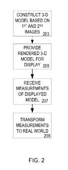
Fig. 2
[00043] Fig. 2 illustrates and describes a method for measuring a real
world object
based on a 3D model of the object according to an embodiment of the invention.
[00044] At step 203 a 3D model of the structure to be measured is
generated. At
step 205, the model is rendered on a display device such that an operator is
enabled to
interact with the displayed image to measure dimensions of the image. At step
207 the
measurements are received. At step 209 the measurements are transformed from
image
measurements to real world measurement. At that point, the measurements are
suitable
for use in provisioning a solar energy system to the structure.
[00045] To carry out step 203 a model generator of the invention receives
the
matching points and generates a 3D model. The 3D model is refined by applying
a novel
optimization technique to the reconstructed 3D structure. The refined 3D model
represents the real world structure with sufficient accuracy to enable usable
measurements of the structure to be obtained by measuring the refined 3D
model.
[00046] To accomplish this, the 3D model is rendered on display device
103.
Dimensions of the displayed model are measured. The measurements are converted
to
real world measurements. The real world measurements are used by a solar
energy
provisioning system to provision the structure with solar panels.
8
CA 02813742 2013-04-04
WO 2012/048304
PCT/US2011/055489
Figs. 3 and 4
[00047] Examples of suitable first and second images are illustrated in
Figs. 3 and
4. Fig 3 illustrates a first image 107 comprising a top plan view of a roof of
a house. For
example, first image 107 is a photograph taken by a camera positioned over the
roof of a
structure so as to capture a top plan view of the roof. In the simplest
embodiment, two
dimensional first image 107 is presumed to have been captured by a
conventional method
of projecting the three dimensional object, in this case a house, onto a 2
dimensional
image plane.
[00048] Fig. 4 illustrates a second image 108 comprising a front elevation
view of
the house illustrated in Fig. 3 including the roof illustrated in Fig. 3. It
is significant to
note the first and second images need not be stereoscopic images. Further, the
first and
second images need not be scanned images. In one embodiment of the invention,
the first
and second photographic images are captured by image capture devices such as
cameras.
[00049] For purposes of this specification the term 'photograph' refers to
an image
created by light falling on a light-sensitive surface. Light sensitive
surfaces include
photographic film and electronic imagers such as Charge Coupled Device (CCD)
or
Complementary Metal Oxide Semiconductor (CMOS) imaging devices. For purposes
of
this specification, photographs are created using a camera. A camera refers to
a device
including a lens to focus a scene's visible wavelengths of light into a
reproduction of what
the human eye would see.
[00050] In one embodiment of the invention first image 107 comprises an
orthographic projection of the real world object to be measured. Generally an
image-
capturing device, such as a camera or sensor, is carried by a vehicle or
platform, such as
an airplane or satellite, and is aimed at a nadir point that is directly below
and/or
vertically downward from that platform. The point or pixel in the image that
corresponds
to the nadir point is the point/pixel that is orthogonal to the image-
capturing device. All
other points or pixels in the image are oblique relative to the image-
capturing device. As
the points or pixels become increasingly distant from the nadir point they
become
increasingly oblique relative to the image-capturing device. Likewise the
ground sample
distance (i.e., the surface area corresponding to or covered by each pixel)
also increases.
9
CA 02813742 2013-04-04
WO 2012/048304
PCT/US2011/055489
Such obliqueness in an orthogonal image causes features in the image to be
distorted,
especially images relatively distant from the nadir point.
[00051] To project a 3D point ax, ay, a, from the real world image onto
the
corresponding 2D point bx, by using an orthographic projection parallel to the
y axis
(profile view), a corresponding camera model may be described by the following
example relationships:
[00052] = sxax + cx
[00053] by = szaz + cz
[00054] where the vector s is an arbitrary scale factor, and c is an
arbitrary offset.
In some embodiments of the invention, these constants are used to align the
first camera
model viewport to match the view presented in first image 105. Using matrix
multiplication, the equations become:
[
b2 0 0 ax
0 0 s- c]
ki = [3 2 [a ijl c
[00055]
[00056] In one embodiment of the invention an orthogonal image is
corrected for
distortion. For example, distortion is removed, or compensated for, by the
process of
ortho-rectification which, in essence, removes the obliqueness from the
orthogonal image
by fitting or warping each pixel of an orthogonal image onto an orthometric
grid or
coordinate system. The process of ortho-rectification creates an image wherein
all pixels
have the same ground sample distance and are oriented to the north. Thus, any
point on
an ortho-rectified image can be located using an X, Y coordinate system and,
so long as
the image scale is known, the length and width of terrestrial features as well
as the
relative distance between those features can be calculated.
[00057] In one embodiment of the invention one of the first and second
images
comprises an oblique image. Oblique images may be captured with the image-
capturing
device aimed or pointed generally to the side of and downward from the
platform that
carries the image-capturing device. Oblique images, unlike orthogonal images,
display
the sides of terrestrial features, such as houses, buildings and/or mountains,
as well as the
tops thereof. Each pixel in the foreground of an oblique image corresponds to
a relatively
small area of the surface or object depicted (i.e., each foreground pixel has
a relatively
CA 02813742 2013-04-04
WO 2012/048304
PCT/US2011/055489
small ground sample distance) whereas each pixel in the background corresponds
to a
relatively large area of the surface or object depicted (i.e., each background
pixel has a
relatively large ground sample distance). Oblique images capture a generally
trapezoidal
area or view of the subject surface or object, with the foreground of the
trapezoid having
a substantially smaller ground sample distance (i.e., a higher resolution)
than the
background of the trapezoid.
Fig. 5
[00058] Once first and second images are selected and displayed point sets
(control
points) are selected. Selection of point sets is accomplished manually in some
embodiments of the invention, for example by an operator. In other embodiments
of the
invention, control points may be automatically selected, for example by
machine vision
feature matching techniques. For manual embodiments an operator selects a
point in the
first image and a corresponding point in the second image wherein both points
represent
the same point in the real world 3D structure.
[00059] To identify and indicate matching points, operator 113 interacts
with the
first and second displayed images to indicate corresponding points on the
displayed first
and second images. In the example of Figs. 3 and 4, point A of real world 3D
structure 1
indicates a right corner of roof 1. Point A appears in first image 107 and in
second image
108, though in different positions on the displayed images.
[00060] In order to indicate corresponding points in the first and second
images
operator places displayed indicia over corresponding portions of an object in
each of 1st
and 2nd images 105, 107. For example, indicia is place over point A of object
102 in first
image 105, and then placed over corresponding point A of object 102 in 2nd
image 107.
At each point the operator indicates selection of the point, for example, by
right or left
mouse click or operation of other selection mechanism. Other devices such as
trackballs,
keyboards, light pens, touch screens, joysticks and the like are suitable for
use in
embodiments of the invention. Thus the operator interacts with the first and
second
images to produce control point pairs as illustrated in Fig. 5.
[00061] In one example embodiment of the invention, a touch screen display
may
be employed. In that case, an operator selects a point or other region of
interest in a
displayed image by touching the screen. The pixel coordinates are translated
from a
11
CA 02813742 2013-04-04
WO 2012/048304
PCT/US2011/055489
display screen coordinate description to, for example, a coordinate system
description
corresponding to the image containing the sensed touched pixels. In other
embodiments
of the invention, an operator uses a mouse to place a marker, or other
indicator, over a
point to be selected on an image. Clicking the mouse records the pixel
coordinates of the
placed marker. System 100 translates the pixel coordinates to corresponding
image
coordinates.
[00062] The control points are provided to a 3D model generator 950 of a
3D
modeling system of the invention. Reconstruction of an imaged structure is
accomplished
by finding intersections of epipolar lines for each point pair.
Figs. 6 and 7
[00063] Fig. 7 illustrates points defining ground planes. In some
embodiments of
the invention a generated 3D model is refined by reference to ground
parallels. Figure 7
illustrates an example list of control points from the example list of control
points
illustrated in Fig. 5 wherein the control points in Fig. 7 comprise ground
parallel lines
according to an embodiment of the invention.
[00064] Fig. 6 illustrates points defining right angles associated with
the object.
Like ground planes, right angles may be used in some embodiments of the
invention to
refine a 3D model.
Fig. 8
[00065] Fig. 8 illustrates a system of the invention. As explained with
respect to
Figs. 1-7 an operator selects first and second image point sets from first and
second
images displayed on a display device 803. A first camera matrix (Camera 1)
receives
point sets from the first image. A second camera matrix (Camera 2) receives
point sets
from the second image. Model generation is initiated by providing initial
parameters for
Camera 1 and Camera 2 matrices.
[00066] In one embodiment of the invention camera parameters comprise the
following intrinsic paramters:
[00067] a.) (u0,v0): coordinates in pixels of the image center which is
the
projection of the camera center on the retina.
[00068] b.) (au,av): scale factors of the image.
12
CA 02813742 2013-04-04
WO 2012/048304
PCT/US2011/055489
[00069] c.) (dimx, dimy) : size in pixels of the image.
[00070] External parameters are defined herein as follows:
[00071] a.) R: rotation which gives axes of the camera in the reference
coordinate
system.
[00072] b) T: pose in mm of the camera center in the reference coordinate
system.
[00073] A camera parameter modeling unit 815 is configured to provide
camera
models (matrix) corresponding to the first and second images. The camera
models are a
description of the cameras used to capture the 1st and 2"d images. The camera
parameter
model of the invention models the first and second camera matrices to include
camera
constraints. The parameter model of the invention accounts for parameters that
are
unlikely to occur or are invalid, for example, a camera position that would
point a lens in
a direction away from an object seen in an image. Thus, those parameter values
need not
be considered in computations of test parameters.
[00074] The camera parameter modeling unit is configured to model
relationships
and constraints describe relationships between the parameters comprising the
first and
second parameter sets based, at least in part on the attributes of the
selected first and
second images.
[00075] The camera parameter model 1000 of the invention embodies
sufficient
information about position constraints on the first and second cameras to
prevent
selection of invalid or unlikely sub-combinations of camera parameters. Thus
computational time to generate a 3D model is less that it would be if
parameters values
for, e.g., impossible or otherwise invalid or unlikely camera positions were
included in
the test parameters.
[00076] In some embodiments, to describe orientation of the first and
second
cameras in 3-dimensional Euclidean space, three parameters are employed.
Various
embodiments of the invention represent camera orientation in different ways.
For
example, in one embodiment of the invention, a camera parameter model
represents
camera positions by Euler angles. Euler angles are three angles describing the
orientation
of a rigid body. In those embodiments a coordinate system for a 3D model space
describes camera positions as if there were real gimbals defining camera
angles
comprising Euler angles.
13
CA 02813742 2013-04-04
WO 2012/048304
PCT/US2011/055489
[00077] Euler angles also represent three composed rotations that move the
reference (camera) frame to the referred (3D model) frame. Thus any
orientation can be
represented by composing three elemental rotations (rotations around a single
axis), and
any rotation matrix can be decomposed as a product of three elemental rotation
matrices.
[00078]
[00079] For each point in a point pair, model unit 303 projects a line of
sight (or
ray) through the corresponding hypothetical camera that captured the image
containing
the point. The line passing through the first image epipole and the line
passing through
the second image epipole would intersect under ideal conditions, e.g., when
the camera
model accurately represents the actual camera employed to capture the image,
when
noise is absent, and when the identification of point pairs was accurate and
consistent
between the first and second photographs.
[00080] 3D model unit 303 determines the intersection of the rays
projected
through the first and second camera models using a triangulation technique in
one
embodiment of the invention. In general, triangulation is the process of
determining the
location of a point by measuring angles to it from known points at either end
of a fixed
baseline, rather than measuring distances to the point directly. The point can
then be fixed
as the third point of a triangle with one known side and two known angles. The
coordinates and distance to a point can be found by calculating the length of
one side of a
triangle, given measurements of angles and sides of the triangle formed by
that point and
two other known reference points. In an error-free context, the intersection
coordinates
comprises the three-dimensional location of the point in 3D model space.
[00081] According to some embodiments of the invention a 3D model
comprises a
three-dimensional representation of the real world structure, wherein the
representation
comprises geometric data referenced to a coordinate system, e.g., a Cartesian
coordinate
system. In some embodiments of the invention a 3-D model comprises a graphical
data
file. The 3-D representation is stored in a memory of a processor (not shown)
for the
purposes of performing calculations and measurements.
[00082] A 3D model can be displayed visually as a two-dimensional image
through a 3D rendering process. Once a system of the invention generates a 3D
model, a
rendering engine 995 and renders 2D images of the model on display device 103.
14
CA 02813742 2013-04-04
WO 2012/048304
PCT/US2011/055489
Conventional rendering techniques are suitable for use in embodiments of the
invention.
Besides rendering, a 3D model is otherwise useful in graphical or non-
graphical
computer simulations and calculations. Rendered 2-D images may be stored for
viewing
later. However, embodiments of the invention described herein enable rendered
2-D
images to be displayed in near real-time on display 103 as operator 113
indicates control
point pairs.
[00083] The 3D co-ordinates comprising the 3D model define the locations
of
structure points in the 3D real world space. In contrast, image co-ordinates
define the
locations of the structures image points on the film or an electronic imaging
device.
[00084] Point coordinates are translated between 3D image coordinates and
3D
model coordinates. For example, the distance between two points lying on a
plane
parallel to a photographic image plane can be determined by measuring their
distance on
the image, if the scale s of the image is known. The measured distance is
multiplied by
1/s. In some embodiments of the invention, scale information for either or
both of the
first and second images are known, e.g., by receiving scale information as
metadata with
the downloaded images. The scale information is stored for use by measurement
unit
119. Thus, measurement unit 119 enables operator 113 to measure the real world
3D
object by measuring the model rendered on display device 103.
[00085]
[00086] Operator 61 selects at least two images for download to system
100. In
one embodiment of the invention, a first selected image is a top plan view of
the home.
A second selected image is a perspective view of the home. Operator 61
displays both
images on display device 70. Using a mouse, or other suitable input device,
operator 61
selects sets of points on the first and second images. For every point
selected in the first
image, a corresponding point is selected in the second image. As described
above, system
100 enables an operator 109 to interact with and manipulate 2 dimensional (2-
D) images
displayed on 2-D display device103. In the simplified example of Fig. 1 at
least one 2-D
image, e.g., first photographic image 105 is acquired from a source of images
10 via a
processor 112. In other embodiments of the invention a suitable source of 2-D
images is
stored in processor 112, and selectable by operator 109 for display on display
device 103.
The invention is not limited with regard to the number and type of images
sources
CA 02813742 2013-04-04
WO 2012/048304
PCT/US2011/055489
employed. Rather, a variety of image sources 10 are suitable for comprising 2-
D images
for acquisition and display on display device 103.
[00087] For example, in the example embodiment described above the
invention is
deployed to remotely measure dimensions of residential structures based on
images of the
structures. In those embodiments commercial geographic image databases such as
those
maintained by MicrosoftTM are suitable sources of 2-D images. Some embodiments
of
the invention will rely on more than one source of 2-D images. For example,
first image
105 is selected from a first image source, and second image 107 is selected
from a second
unrelated image source. Images obtained by consumer grade imaging devices,
e.g.,
disposable cameras, video cameras and the like are suitable for use in
embodiments of the
invention. Likewise, professional images obtained by satellite, geographic
survey
imaging equipment, and a variety of other imaging equipment providing
commercial
grade 2-D images of real world objects are suitable for use in the various
embodiments of
the invention.
[00088] According to one alternative embodiment, 1st and 2nd images are
scanned
using a local scanner coupled to processor 112. Scan data for each scanned
image is
provided to processor 112. The scanned images are displayed to operator 109 on
display
device 103. In another alternative embodiment, imaging capture equipment is
located on
the site at which the real world house is located. In that case, image capture
equipment
provides images to processor 112 via the Internet. The images may be provided
in real
time, or stored to be provided at a future time. Another source of images is
an image
archiving and communications system connected to processor 112 via a data
network. A
wide variety of methods and apparatus capable of generating or delivering
images are
suitable for use with various embodiments of the invention.
[00089]
Refining the Model
[00090] In practice, epipolar geometry is imperfectly embodied in a real
photograph. 2-D coordinates of control points from the first and second images
cannot
be measured with arbitrary accuracy. Various types of noise, such as geometric
noise
from lens distortion or interest point detection error, lead to inaccuracies
in the control
16
CA 02813742 2013-04-04
WO 2012/048304
PCT/US2011/055489
point coordinates. In addition, the geometry of first and second cameras is
not perfectly
known. As a consequence, the lines projected by 3D model generator from the
corresponding control points via the first and second camera matrices do not
always
intersect in 3D space when triangulated. In that case, an estimate of the 3D
coordinates is
made based on an evaluation of the relative line position of the lines
projected by the 3D
model generator. In one embodiment of the invention, the estimated 3D point is
determined by identifying a point in 3D model space representing the closest
proximal
relationship of the first control point projection to the second control point
projection.
[00091] This estimated 3D point will have an error proportional to its
deviation
from the same point on the real world structure, had a direct and error free
measurement
been made of the real world structure. In some embodiments of the invention
the
estimated error represents the deviation of the estimated point from the 3D
point that
would have resulted from a noise-free, distortion-free, error-free projection
of a control
point pair. In other embodiments of the invention the estimated error
represents the
deviation of the estimated point from the 3D point that represents the 'best
estimate' of
the real world 3D point based on criteria defined externally, such as by an
operator, in the
generation of the 3D model.
[00092] Re-projection error is a geometric error corresponding to the
image
distance between a projected point and a measured one. Reprojection quantifies
how
closely an estimate of a 3D point 5( recreates the point's true projection X.
More
precisely, let Pbe the projection matrix of a camera and Xbe the image
projection of X,
i.e. = P X. The reprojection error of Xis given by d(x, x), where 61(X:
4denotes
the Euclidean distance between the image points represented by vectors xand X.
[00093] To generate a 3D model representing, as closely as possible, the
modeled
3D real world structure, is would be desirable to minimize re-projection
error. Therefore,
in order to produce a 3D model with an accuracy sufficient to measure
dimensions, e.g.,
for the purpose of installing solar panels, embodiments of the invention
adjust first and
second camera descriptions to bring the projected lines as close as possible
to intersection
while ensuring the estimated 3D point lies within the constraints of the
camera parameter
model.
17
CA 02813742 2013-04-04
WO 2012/048304
PCT/US2011/055489
[00094] In one embodiment of the invention the 3D model coordinates
generated
as described above are refined. Given a number of 3D points comprising a 3D
model
generated by projecting control point pairs through a camera model, the camera
parameters and the 3D points comprising the model are adjusted until the 3D
model
meets an optimality criterion involving the corresponding image projections of
all points.
It amounts to an optimization problem on the 3D image and viewing parameters
(i.e.,
camera pose and possibly intrinsic calibration and radial distortion), to
obtain a
reconstruction which is optimal under the constraints of the parameter model.
The
technique of the invention effectively minimizes the reprojection error
between the image
locations of observed and predicted image points, which is expressed as the
sum of
squares of a large number of nonlinear, real-valued functions. This type of
minimization
is typically achieved using nonlinear least-squares algorithms. Of these,
Levenberg¨
Marquardt is frequently employed. Levenberg¨Marquardt iteratively linearizes a
function to be minimized in the neighborhood of the current estimate. This
algorithm
involves the solution of linear systems known as the normal equations. While
effective,
even a sparse variant of the Levenberg¨Marquardt algorithm which explicitly
takes
advantage of the normal equations zeros pattern, avoiding storing and
operating on zero
elements, consumes too much time in the calculation process to be of practical
use in
applications for which the present invention is deployed.
[00095]
Fig. 8
[00096] Figure 8 is a flow chart illustrating steps of a method for
generating a 3-D
model of an object based on at least two 2-D images of the object according to
an
embodiment of the invention.
[00097] At 805 control points selected by an operator are received. For
example,
an operator selects a portion, A of a house from a first image including the
house. The
operator selects the same portion A of the same house from second image
including the
same house. Display coordinates for operator selected portions of the house
depicted in
the first and second images are provided to processor. At 807, initial camera
parameters
are received, e.g., from the operator. At 809 remaining camera parameters are
calculated
18
CA 02813742 2013-04-04
WO 2012/048304
PCT/US2011/055489
based, at least in part on a camera parameter model. The remaining steps 811
through 825
are carried out as described in Figure 8.
Fig. 9
[00098] Figure 9 illustrates and describes a method for minimizing error
in a
generated 3D model according to an embodiment of the invention.
Fig. 10
[00099] In one embodiment of the invention each of the first and second
cameras
are modeled as a camera mounted on camera bearing platform positioned in 3D
model
space (915 916). The platform, in turn is coupled to a 'camera gimbal'.
Impossible
camera position is thus embodied as a 'gimbal lock' position. Gimbal lock is
the loss of
one degree of freedom in a three-dimensional space that occurs when the axes
of two of
the three gimbals are driven into a parallel configuration, "locking" the
system into
rotation in a two-dimensional space.
[000100] The model of Fig. 10 represents one advantageous configuration and
method for rapidly determining optimal l' and 2nd camera matrices for
projecting 2-D
image control points to a model space according to an embodiment of the
invention.
According to the model initial parameters for first and second camera matrices
assume
that apertures of the corresponding hypothetical cameras (915, 916) are
arranged as to be
directed toward the center of sphere 905. Further, one camera 916 is modeled
as
positioned with respect to sphere 901 at coordinates x0, y 1 , zO, of
coordinate axis 1009
i.e., positioned at the top of the upper hemisphere of the sphere with its
aperture aimed
directly downward toward the center of the sphere.
[000101] In addition, the range of possible positions is constrained to
positions on
the surface of the sphere and further to the upper hemisphere of the sphere.
Further, the
x axis position of camera 915 is set to remain at x=0. Accordingly positions
assumed by
camera 915, conforming to the above constraints, will lie on the z axis
between z = 1 and
z = -1, wherein position of camera 915 with respect to they axis is determined
by z axis
position. Each of cameras 915 and 916 are free to rotate about their
respective optical
axes.
19
CA 02813742 2013-04-04
WO 2012/048304
PCT/US2011/055489
[000102] The arrangement illustrated in Fig. 10 provides camera matrix
initialization parameters that facilitate convergence of 3-D point estimates
from an initial
estimate to an estimate meeting defined convergence criteria.
[000103] Initial values thus obtained for intrinsic camera parameters are
established
during an initialization step of the methods illustrated in Figs. 11 and 12.
These are not
changed during execution of the method. On the other hand, permutations of
extrinsic
parameters for successive iterations of simulation methods of the invention
are reduced
by fixing the position of one camera along two axes, and fixing the position
of the other
camera along one axis.
Fig. 11 Parameter Method
[000104] Figure 11 illustrates and describes a method for determining
camera 1
(Cl) pitch, yaw and roll, based on Cl initial parameters given by the
parameter model
illustrated in Fig. 10.
Fig. 12 ¨ Parameter Method
[000105] Likewise, Figure 12 illustrates and describes a method for
determining
camera 2 (C2) pitch, yaw and roll, based on C2 initial parameters given by the
parameter
model illustrated in Fig. 10.
Fig. 13- Example GUI Screenshot
[000106] Figure 13 is a screenshot of a graphical user interface enabling
an operator
to interact with displayed first and second images according to an embodiment
of the
invention.
Fig. 14 ¨ Simulation Method¨ Using lowest error output
[000107] Figure 14 is a flowchart illustrating and describing steps of a
method for
generating a 3D model while minimizing error in the generated 3D model.
Fig. 15 ¨ Camera Parameter and Simulation Method
[000108] Figure 15 is a flowchart illustrating and describing steps of a
method for
generating a 3D model according to an embodiment of the invention.
CA 02813742 2013-04-04
WO 2012/048304
PCT/US2011/055489
Fig. 16
[000109] is a conceptual diagram illustrating an example 3D model generator
providing a 3D model based projection of point sets from first and second
images
according to an embodiment of the invention. Figure 16 depicts, at 1, 2 and 3,
the 3D
points of a 3D model that correspond to the 2D points in the first and second
images. A
3D model generator operates on the control point pairs to provide a
corresponding 3D
point for each control point pair. For first and second image points of first
and second
images respectively (corresponding to the same three-dimensional point) the
image points
and the three-dimensional point and the optical centers are coplanar.
[000110] An object in 3D space can be mapped to the image of the object in
the 2D
space of an image through the viewfinder of the device that captured the image
by
perspective projection transformation techniques. The following parameters are
sometimes used to describe this transformation:
= az-;- the point in real world 3D space that is to be projected.
= cz,Y,';- the actual real world location of the camera.
= The rotation of the real world camera. When cz,Y,z= (0) 07 0) !and
0 = (0. 0. CO
z,Y,1 the 3D vector <1,2,0> is projected to the 2D vector
<1,2>.
= z- the viewer's position relative to the real world display surface.
Which results in:
= bz,Y- the 2D projection of a.
[000111] The invention employs the reverse transformation of the above. In
other
words, the invention maps a point on an image of the object in the 2D space,
as viewed
through the viewfinder of the device that captured the image. To accomplish
this, the
invention provides cam 1 matrix 731 and camera 2 matrix 732 to reconstruct the
3D real
world object in model form by projecting point pairs onto 3D model space 760.
[000112] Camera matrix 1 and 2 are defined by camera parameters. Camera
parameters may include 'intrinsic parameters' and 'extrinsic parameters'.
Extrinsic
parameters define an exterior orientation of a camera, e.g., location in space
and view
direction. Intrinsic parameters define the geometric parameters of the imaging
process.
21
CA 02813742 2013-04-04
WO 2012/048304
PCT/US2011/055489
This is primarily the focal length of the lens, but can also include the
description of lens
distortions.
[000113] Accordingly, a first camera model (or matrix) comprises a
hypothetical
description of the camera that captured the first image. A second camera model
(or
matrix) comprises a hypothetical description of the camera that captured the
second
image. In some embodiments of the invention, camera matrices 731 and 732 are
constructed using camera resectioning techniques. Camera resectioning is the
process of
finding the true parameters of the camera that produced a given photograph or
video.
Camera parameters are represented in a 3 x 4 matrices comprising Camera Matrix
1 and
2.
[000114]
Fig. 17 ¨ Camera Matrices and Model Space
[000115] Figure 17 illustrates a 3D model space into which control
points are
projected by first and second camera models.
[000116] The term 'camera model' as used herein refers to a 3X4 matrix
which
= describes the mapping of 3D points comprising a real world object through
a pinhole
camera to 2D points in a 2D image of the object. In that case, the 2D scene,
or
photographic frame is referred to as a viewport.
[000117] The distance between the camera and the projection plane, d;
and the
dimensions of the viewport, vw and vh. These values taken together determine
the field of
view of the projection, that is, the angle which is visible in the projected
image :
viewport
vh vh
tt 1
tan(r) .-- 0.5 * vh /d
(N. atan(0.5 * vh / d)
z di z = d2
[000118]
Projectors
22
CA 02813742 2013-04-04
WO 2012/048304
PCT/US2011/055489
[000119] The first and second camera matrices project a ray from each 2-D
control
point from first and second images through a hypothetical camera configured in
accordance with the camera model and into the 3-D image space in which the 3-D
model
will be provided.
[000120] Thus each camera matrix projects rays in accordance with its own
camera
matrix parameter settings. Since actual camera parameters for the cameras
providing st
and 2"d images are not known, one approach is to estimate the camera
parameters.
[000121] It is also known that a given set of 2-D points to be projected
via first and
second camera matrices correspond to the same point in an ideal projection
into a 3-D
model. With this knowledge camera parameter estimation according to principles
of the
invention comprises steps of providing manually estimated initial values,
testing for
convergence, and adjusting the camera matrices based on the results of the
convergence
test.
Fig. 18 - Image Registration Method
[000122] Figure 18 illustrates and describes steps of a method for
registering first
and second images with respect to each other according to an embodiment of the
invention.
Fig. 20 Method for 3D Model Generation
[000123] Figure 20 illustrates and describes steps of a method for bundle
adjustment
according to an embodiment of the invention.
Fig. 21 Model Generator
[000124] Figure 21 is a block diagram of a 3D model generator according to
an
embodiment of the invention.
Fig. 22 Model Generating Method Overview
[000125] Figure 22 is a flowchart illustrating and describing steps of a
method for
bundle adjustment according to an embodiment of the invention.
Fig. 23 Model Generator Embodiment
[000126] Figure 23 is a block diagram of a camera modeling unit according
to an
embodiment of the invention.
23
CA 02813742 2013-04-04
WO 2012/048304
PCT/US2011/055489
[000127] The components comprising system 100 are implementable as separate
units and alternatively integrated in various combinations. The components are
implementable in a variety of combinations of hardware and software.
[000128] While the present invention has been described as having a
preferred
design, the invention can be further modified within the spirit and scope of
this
disclosure. This disclosure is therefore intended to encompass any equivalents
to the
structures and elements disclosed herein. Further, this disclosure is intended
to
encompass any variations, uses, or adaptations of the present invention that
use the
general principles disclosed herein. Moreover, this disclosure is intended to
encompass
any departures from the subject matter disclosed that come within the known or
customary practice in the pertinent art and which fall within the limits of
the appended
claims. While the invention has been shown and described with respect to
particular
embodiments, it is not thus limited. Numerous modifications, changes and
enhancements
will now be apparent to the reader.
24