Note: Descriptions are shown in the official language in which they were submitted.
SEISMIC SURVEYING TECHNIQUES WITH ILLUMINATION AREAS
IDENTIFIABLE FROM PRIMARY AND HIGHER-ORDER REFLECTIONS
BACKGROUND
Marine seismic surveys may utilize energy, such as sound, that is transmitted
to subsurface
features and reflected back to sensors. The sensors may be configured as part
of a number of
streamers that may be towed behind a survey vessel. These streamers may be
configured as
a submerged array of multiple streamers, that may be arranged in parallel.
One common application of marine seismic surveying is oil and gas exploration
in marine
environments. For example, sound waves received during a marine seismic survey
may be
analyzed to locate hydrocarbon bearing geological structures, and thus
determine the
location of oil and natural gas deposits. To this end, survey paths may be
calculated in order
to provide optimal survey coverage of an area of interest. Such surveys paths
may require a
survey vessel to conduct numerous survey passes to adequately cover the area
of interest.
SUMMARY OF EMBODIMENTS OF THE INVENTION
In accordance with an aspect of at least one embodiment, there is provided a
method
including: towing a plurality of sensor streamers behind a survey vessel;
gathering, based on
data received at sensors along the plurality of sensor streamers, information
corresponding to
primary reflections and information corresponding to higher-order reflections;
determining,
based on the gathered information, a subsurface illumination area identifiable
from the
primary reflections and the higher-order reflections, wherein the subsurface
illumination area
has a dimension in a cross-line direction that is greater than one-half of the
cross-line
distance from a first outermost streamer to a second outermost streamer; and
navigating the
survey vessel in a survey pattern, wherein said navigating is based on the
determined
subsurface illumination area.
In accordance with another aspect of at least one embodiment, there is
provided a method,
including: determining a subsurface illumination area identifiable from
primary reflections
CA 2815269 2018-11-23
and higher-order reflections detected by sensors along a plurality of sensor
steamers being
towed by a survey vessel, wherein said determining the subsurface illumination
area includes
determining a dimension in a cross-line direction, wherein the dimension is
greater than one-
half of the cross-line distance from a first outermost streamer to a second
outermost
streamer; and determining a survey pattern for the survey vessel based on the
determined
subsurface illumination area.
In accordance with a further aspect of at least one embodiment, there is
provided a system,
including: a data acquisition system configured to gather information detected
at sensors
In along a plurality of sensor streamers that are towed behind a survey
vessel, wherein the
gathered information includes data corresponding to primary reflections and
data
corresponding to higher-order reflections; and a navigation system configured
to navigate
the survey vessel in a survey pattern, wherein the survey pattern is based on
a subsurface
illumination area identifiable from the data corresponding to the primary
reflections and the
data corresponding to the higher-order reflections, and wherein the subsurface
illumination
area has a dimension in a cross-line direction that is greater than one-half
of the cross-line
distance from a first outermost streamer to a second outermost streamer.
BRIEF DESCRIPTION OF THE DRAWINGS
Fig. 1 depicts an example seismic survey vessel, suitable for executing
techniques according
to embodiments disclosed herein, towing sensor streamers and a seismic source
in a body of
water.
Fig. 2A depicts one example of primary and multiple reflections that may be
received at a
sensor and gathered for use in imaging in various embodiments.
Fig. 2B illustrates the primary and multiple reflections depicted in the
example of Fig. 2A,
along with an additional higher-order multiple reflection.
la
CA 2815269 2018-11-23
Fig. 3 depicts a surface illumination area based on imaging using primary and
multiple
reflections in accordance with some embodiments.
lb
CA 2815269 2018-11-23
i
CA 02815269 2013-05-07
Fig. 4 depicts an example survey path that may be determined using techniques
in
accordance with some embodiments.
Fig. 5 is a flow diagram illustrating a method for navigating a survey vessel
in accordance
.. with one embodiment.
Fig. 6A is a flow diagram illustrating a method for determining a survey
pattern with a
subsurface illumination area that is based on imaging using primary
reflections and
multiple reflections.
Fig. 6B is a flow diagram illustrating a method for determining a survey
pattern that
includes a shot sampling plan for use with a subsurface illumination area that
is based on
imaging using primary reflections and higher-order reflections.
Fig. 7 is a block diagram of one embodiment of a system that includes a data
acquisition
system and a navigation system, according to various embodiments of the
present
disclosure.
DETAILED DESCRIPTION
This specification includes references to "one embodiment" or "an embodiment."
The
appearances of the phrases "in one embodiment" or "in an embodiment" do not
necessarily refer to the same embodiment.
Particular features, structures, or
characteristics may be combined in any suitable manner consistent with this
disclosure.
Terminology. The following paragraphs provide definitions and/or context for
terms
found in this disclosure (including the appended claims):
"Usable By." In the context of "element X is 'usable by' system Y to do Z,"
this phrase
refers to a situation in which system Y is configured to perform function Z
using (e.g.,
2
CA 02815269 2013-05-07
reading, manipulating, executing) element X. Thus, if a system is configured
to
determine a subsurface illumination area by performing various operations
based on
detected and gathered information, it can be said that the detected and
gathered
information is "usable by" the system to determine the subsurface illumination
area.
"First," "Second," etc. As used herein, these terms are used as labels for
nouns that they
precede, and do not imply any type of ordering (e.g., spatial, temporal,
logical, etc.)
unless otherwise indicated.
"Based On." As used herein, this term is used to describe one or more factors
that affect
a determination. This term does not foreclose additional factors that may
affect a
determination. That is, a determination may be solely based on those factors
or based
only in part on those factors. Consider the phrase "determine A based on B."
While B
may be a factor that affects the determination of A, such a phrase does not
foreclose the
determination of A from also being based on C. In other instances, A may be
determined
based solely on B.
"Comprising." This is an open-ended term meaning "including the following
elements
(or their equivalents) but not excluding others." As used in the appended
claims, this
term does not foreclose additional structure or steps. Consider a claim that
recites: "A
system, comprising one or more sensor streamers . . . ." Such a claim does not
foreclose
the system from including additional components (e.g., a seismic source, data
acquisition
systems, navigations systems). "Including" and "having" are similarly used
terms that are
also open-ended.
"Configured To." As used herein, this term means that a particular piece of
hardware or
software is arranged to perform a particular task or tasks when operated.
Thus, a system
that is "configured to" perform task A means that the system may include
hardware
and/or software that, during operation of the system, performs or can be used
to perform
task A. (As such, a system can be "configured to" perform task A even if the
system is
not currently operating.)
3
I
CA 02815269 2013-05-07
* * *
An exemplary configuration for seismic survey path planning and design is
depicted in
the plan view of Fig. 1. Survey vessel 110 may tow one or more sources 120 and
a
plurality of sensor streamers 130 in in-line direction 101. Alternatively, in
some
embodiments, source(s) 120 and streamers 130 may be towed by separate vessels
or
otherwise suitably disposed in the body of water. The various sensor streamers
130 may
in some cases be arranged in a substantially parallel manner (spaced in cross-
line
direction 102) in order to provide imaging of a subsurface area. The imaging
may be
performed using received data corresponding to reflection/scattering of
signals (e.g.,
pressure waves) generated by source 120. As depicted, the various sensor
streamers 130
are arranged parallel to the in-line tow direction of survey vessel 110. In
some
embodiments, the various sensor streamers 130 may be arranged in a
configuration that is
offset from the towing direction of survey vessel 110 (e.g., aligned according
to an angle
that is offset from the towing direction), and/or in a configuration in which
the various
sensor streamers 130 are not substantially parallel to each other (e.g.,
aligned according to
differing angles from the towing direction).
Each of the various sensor streamers 130 may include a number of sensors 140.
Sensors
140 may include, for example, submerged pressure sensors (e.g., hydrophones)
and
velocity sensors (e.g., geophones). Sensor streamer 130 may also include
various
additional components, such as steering devices.
Although Fig. 1 depicts a configuration using eight sensor streamers and one
seismic
source, embodiments of the present disclosure may employ configurations using
more
than one source, and/or differing numbers of sensor streamers. Furthermore,
the number
of sensors 140 depicted in Fig. 1 is for illustrative purposes, and various
embodiments of
the present disclosure may use a different number of sensors per streamer. In
some
embodiments, the various streamers may not all include the same number of
streamers.
In some embodiments, the sensors may be disposed in differing patterns, and/or
may be
irregularly spaced on the various streamers.
4
I
i
CA 02815269 2013-05-07
Turning now to Figs. 2A and 2B, views looking forward depict examples of
primary and
multiple reflections that may in some cases be used in imaging a subsurface
illumination
area. As shown in Fig. 2A, source 120 may cause primary reflections and
various higher-
order reflections to be received at sensors such as outermost sensor 140a.
Fig. 2A depicts
exemplary primary reflection 230, in which a waveform from source 120 is
reflected once
by reflector 202 (e.g., sea floor, subfloor features) before reaching sensor
140a. Fig. 2A
also depicts exemplary higher-order reflection 220, in which a waveform is
reflected
multiple times before reaching 140 (in this example, the waveform in question
is reflected
three times by reflector 202 and twice by sea surface 201, for a total of five
times. The
term "higher-order reflections" thus refers to a waveform has been reflected
at least twice
between the source and the destination sensor.
Conventional seismic acquisition methods that employ imaging based only on
primaries
may define the subsurface illumination area by the midpoint spread (e.g.,
modeling
subsurface structures as horizontally-layered media in survey planning). In
such cases,
the midpoint position may be a vector given by half of the sum of the receiver
position
vector and the source position vector. The cross-lines may be sequential
numbers of the
midpoints of a nominal source receiver configuration projected on the cross-
line axis (the
axis in the cross-line direction, perpendicular to the main sail line
direction). The in-lines
may be sequential numbers of the midpoints of a nominal source receiver
configuration
projected on the in-line axis (the axis in the in-line direction, parallel to
the main sail line
direction). The distance between consecutive in-lines and cross-lines may be
given by the
projection of the difference of consecutive midpoint vectors of a nominal
source receiver
configuration (e.g., a 3D streamer vessel) on the in-line axis and the cross-
line axis,
respectively. Thus, a primary reflected waveform 230 received at outermost
sensor 140a
may provide an outer-most boundary of an illumination area providing imaging
of
reflector 202 (e.g., sea floor, subsurface features) up to distance 212 (one-
half of the
distance 211 from source 120 to sensor 140a). Thus, marine seismic surveys
patterns
designed to correspond to these conventional methods may require sail line
separations
corresponding to half of the total streamer spread (e.g., the number of
streamers times the
5
streamer separation divided by two, the distance between the cross-lines of
the outermost
streamers) in order to provide full coverage of the area of interest.
Similarly, the number
(e.g., frequency) of shots that may be required to provide a desired in-line
coverage may be
determined based on the in-line dimensions of the illumination area.
In contrast to conventional marine seismic acquisition systems, dual (or
multiple) sensor and
dual (or multiple) streamer acquisition may allow separating upward-
propagating wavefields
from downward-propagating wavefields. The separated wavefields may provide for
suppressing receiver ghost-related spectral notches, thereby resulting in high
resolution
images.
For certain parts of the spectral content of seismic signals (e.g., where
motion sensors are
noise contaminated), and under certain limiting sea surface conditions, the
wavefield
separation may be performed using only pressure sensors in conventional
streamer
acquisition. See U.S. Patent Nos. 7,359,283 and 7,835,225.
In contrast to conventional methods, techniques disclosed herein may be
employed to
determine navigation paths for marine seismic surveying based on subsurface
illumination
that results from imaging using separated wavefields (e.g., the complete
upward-propagating
and downward-propagating wavefields), including primary reflections and
multiples. For
example, Whitmore et al. describes imaging of primaries and multiples using
dual-sensor
data, dual-streamer wavefield separation, downward extrapolation, and the
application of
imaging conditions. See N.D. Whitmore, A.A. Valenciano, W. Sollner, S. Lu,
Imaging of
primaries and multiples using a dual-sensor towed streamer, 2010 Annual
International
Meeting, SEG, 3187-3192. In contrast to imaging principles using only
primaries (e.g.,
techniques that may filter data corresponding to multiples as noise), imaging
using the
complete separated wavefields (including primary reflections and higher-order
reflections)
may allow downgoing wavefields at each sensor location (e.g., downgoing
portions of
multiple reflection wavefield 220) to be regarded as a secondary source. Thus,
the
subsurface illumination area in both the cross-line direction and the in-line
6
CA 2815269 2018-05-07
i
CA 02815269 2013-05-07
direction that may be imaged may be extended substantially. For example, Fig.
2A
depicts a subsurface illumination area extending from the source to at least
the middle
between the two outermost streamers. More specifically, Fig. 2A illustrates an
example
of imaging using primaries and multiples to facilitate imaging of reflector
202 in the
cross-line direction to distance 213, which is the distance from source 120 to
the mid-
point distance (distance 215) in the cross-line direction of the total
distance between
outermost sensor 140a (located at distance 211) and the next outermost sensor
140b
(located at distance 214 in the cross-line direction from sensor 140a).
Fig. 2B depicts an example of an even greater subsurface illumination area
that may be
imaged in cases where higher-order multiples are utilized. The depicted
subsurface
illumination area, which is determined further based on higher-order multiple
refection
wavefield 240, extends a distance 216 that is almost the entire cross-line
distance between
source 120 and sensor 140a. As this principle is extended to very high-order
multiples,
the wavefield may in some cases behave like a downgoing plane wave (e.g., a
source
wavefield at the complete extent of the acquisition surface), and the
resulting imaged area
may in some cases cover the complete streamer spread. Generally, actual sea
surfaces are
not completely flat, but instead will typically represent some degree of
roughness (e.g.,
dependent on the weather conditions). As a consequence, downward-propagating
wavefields may generally be considered as omni-directional scattered
wavefields at every
receiver position. In various exemplary embodiments, the resulting imaged area
may
have a cross-line dimension that is at least 95% of the cross-line distance
between the two
outermost streamers.
In seismic data obtained using embodiments of marine acquisition
configurations that
may employ dual sensors and one or more active sources, and that may use
imaging
technology that is based on the principle of imaging with separated
wavefields, the
complete downward-propagating wavefield may act as "simultaneous sources" at
every
receiver position. Conventional seismic surveys using active sources at every
receiver
position (e.g., symmetric sampling) provide favorable configurations with
respect to
faithful wavefield reconstruction. Embodiments of the present disclosure may
achieve
7
CA 02815269 2013-05-07
"simultaneous symmetric sampling" (e.g., without the use of active sources at
every
receiver position) by combining dual sensor acquisition with the principle of
imaging
with separated wavefields.
These techniques also apply to the subsurface illumination area in the in-line
direction, as
discussed in more detail with regard to Fig. 3. Accordingly, the present
techniques may
be used to determine seismic survey navigation paths based on larger
subsurface
illumination areas by taking primaries and multiples into account, thereby
reducing the
acquisition effort by reducing the number of passes that a survey vessel must
complete to
image an area of interest.
Furthermore, this use of multiples may also provide increased fold (e.g.,
increased
received seismic data representative of the area of illumination) in the cross-
line and/or
the in-line directions. For example, higher-order multiple refection wavefield
240 that is
depicted in Fig. 2B may provide greatly increased seismic data (per shot from
source 120)
that may be received by various sensors 140. Accordingly, the present
techniques may
achieve a desired subsurface fold using less active shots than that which is
used in
conventional methods of imaging based only on primaries.
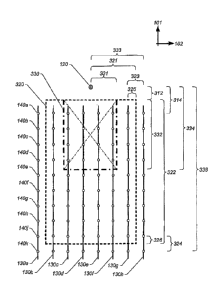
Fig. 3 provides a plan view illustrating one example of the greater subsurface
illumination
area that may be determined using embodiments of the present techniques, and
the
improved navigation path (e.g., based on larger-spaced sail lines) that may be
determined.
In this example, subsurface illumination area 330 represents an illumination
area that
may be achieved via conventional techniques of imaging using only primaries.
The
cross-line dimension of the subsurface illumination area 330 extends in the
cross-line
direction 102 for distance 331 from source 120. As discussed above, distance
331 is one-
half of the distance to the outermost streamer 130h (one-half of distance
333). Thus, the
overall cross-line direction of subsurface illumination area 330 may be
expressed as one-
half the cross-line distance between the two outermost streamers 130a and
130h.
Similarly, the in-line dimension of the subsurface illumination area that may
be achieved
8
CA 02815269 2013-05-07
via conventional techniques of imaging using only primaries is distance 332 in
the
example of Fig. 3. This distance is the distance between the mid-point 312 in
the in-line
direction of the distance between the source and the forward-most sensors
(distance 314),
and the mid-point 334 in the in-line direction of the distance between the
source and the
aft-most sensors (distance 336).
In contrast, one example of the improved illumination area provided by the
present
techniques is depicted in this example as subsurface illumination area 320.
The depicted
cross-line dimension of the subsurface illumination area 320 (which is greater
than the
above-described cross-line dimension of area 330) extends in the cross-line
direction 102
for distance 321 from source 120. As discussed above, distance 321 is the
cross-line
distance from source 120 to the mid-point 325 in the cross-line direction of
the distance
323 between the outermost streamer 130h and the next-outermost streamer 130g.
Thus,
the overall cross-line direction of subsurface illumination area 320 may be
expressed as
the sum of the cross-line distance between the port-side next-outermost
streamer and the
starboard-side next outermost streamer (streamers 130b and 130g), one-half of
the cross-
line distance between the port next-outermost streamer 130b and the port outer-
most
streamer 130a, and one-half of the cross-line distance between the starboard
next-
outermost streamer 130g and the starboard outer-most streamer 130h.
As discussed above, in other examples the subsurface illumination area may
approach, or
equal, the distance between the two outermost streamers (e.g., port outer-most
streamer
130a and starboard outer-most streamer 130h). In some examples, the subsurface
illumination area may be greater than or equal to 95% of the distance between
the two
outermost streamers
Embodiments of the present techniques may be used to provide a similarly
improved
subsurface illumination area in the in-line direction. For example, the in-
line dimension
of subsurface illumination area 320 of Fig. 3 (which is greater than the above-
described
cross-line dimension of area 330) is the distance between 1) the mid-point 312
in the in-
line direction of the distance between the source and the fore-most sensors
(distance 314),
9
I I
CA 02815269 2013-05-07
and 2) the mid-point 326 in the in-line direction of the distance 324 between
the next aft-
most sensors (e.g., 140k) and the aft-most sensors (e.g., 140j).
In various embodiments, an improved surface illumination area permits a vessel
to
perform a survey pattern that includes fewer passes over a given area.
Referring to Fig. 4
for example, a vessel 110 implementing the techniques described herein may
have a
survey pattern that includes survey paths 410a and 410b having a spacing 420.
In this
instance, the spacing 420 between paths 410 may be significantly greater than
the spacing
between paths performed by a vessel using traditional surveying techniques.
Still further,
in some embodiments, vessel 110 performs a survey pattern that includes a shot
sampling
to plan than is not as dense as prior plans due to the size of the improved
surface
illumination area. That is, vessel 110 may perform fewer shots spaced further
apart to
achieve a desired subsurface coverage.
Turning now to Fig. 5, a flow diagram of one embodiment of a method for
navigating a
survey vessel in a survey path is shown. Method 500 includes towing a
plurality of
sensor streamers (e.g., in an in-line direction behind a survey vessel 110).
Method 500
further includes gathering information received at sensors disposed along the
plurality of
sensor streamers 520. The gathered information includes data corresponding to
primary
reflections and data corresponding to higher-order reflections. At 530, the
method
includes navigating the survey vessel in a survey pattern. This navigating may
be based
on a subsurface illumination area identifiable from information corresponding
to the
primary reflections and information corresponding to the higher-order
reflections. In
some embodiments, the navigating includes implementing a shot sampling plan
based on
the size of the subsurface illumination area. Accordingly, in one embodiment,
survey
vessel may adjust the shot sampling plan by decreasing or increasing the rate
at which
shots are performed (i.e., the shot density) after or in response to a change
in the
subsurface illumination area (i.e., an increase or decrease in the current
size of the area).
In one embodiment, this adjustment may be performed automatically by a data
acquisition
system of the survey vessel such as data acquisition system 710 discussed
below with
respect to Fig. 7.
CA 02815269 2013-05-07
The plurality of sensor streamers may include a first outermost streamer, a
second
outermost streamer, and two or more sensor streamers disposed between the
first and
second outermost streamers. The two or more sensor streamers disposed between
the
first and second outermost streamers include a third streamer that is closest
to the first
outermost streamer, and a fourth streamer that is closest to the nearest of
the plurality of
sensor streamers to the second outermost streamer. In Fig. 3, for example, the
first and
second outermost streamers may be streamers 130a and 130h, respectively. The
third and
fourth streamers that are closest to the first and second outermost streamers
are streamers
130b and 130g, respectively (these streamers are adjacent to streamers 130a
and 130h.)
In some cases, the navigating is based on a subsurface illumination area that
comprises a
dimension (e.g., a width) in a cross-line direction that is at least the sum
of the cross-line
distance between the third streamer and the fourth streamer, one-half the
cross-line
distance between the first outermost streamer and the third streamer, and one-
half the
cross-line distance between the second outermost streamer and the fourth
streamer.
Some embodiments may include a single seismic energy source. In other
embodiments,
multiple sources may be used.
Figure 6A presents a flow diagram of a method 600 for determining a survey
pattern. At
610, the method includes determining a subsurface illumination area
identifiable from
detected primary reflections and higher-order reflections. These primary and
higher-order
reflections may be detected by sensors disposed in a streamer configuration
that includes
a plurality of towed sensor streamers. In some embodiments, a data acquisition
system of
the survey vessel (e.g., data acquisition system 710 described below with
respect to Fig.
7) determines the subsurface illumination area by tracking locations of the
sensor
streamers. For example, in one embodiment, the data acquisition system may
track
multiple coordinate positions (e.g., relative to in-line and cross-line axes)
along a given
streamer, where positions may correspond to ones of the sensors in the
streamer (e.g., the
forward-most sensor, aft-most sensor, and one or more intermediary sensors).
In some
embodiments, the data acquisition system determines (e.g., in real time) an
instant
subsurface illumination area based on the locations. In one embodiment, this
area may be
11
CA 02815269 2013-05-07
determined by determining an instant dimension in an in-line direction and an
instant
dimension in a cross-line direction for the sensor streamers based on various
criteria
discussed above. At 620, the method includes determining a survey pattern
based on the
subsurface illumination area. In some embodiments, determining the survey
pattern
includes selecting a heading for the survey vessel (e.g., a bearing
corresponding a path
410) based on the instant subsurface illumination area and providing the
selected heading
to a navigation system of the survey vessel (e.g., navigation system 720
discussed below
with respect to Fig. 7). In such an embodiment, the navigation system may be
configured
to adjust a current heading of the survey vessel to be the selected heading.
For example, a
survey vessel may encounter a cross current that initially causes a portion of
the starboard
sensor streamers to move leeward¨thus reducing the subsurface illumination
area. In
response to detecting this reduction of area, in one embodiment, the survey
vessel may
change its heading to account for potential blind spots caused by this
reduction. (In some
embodiments, the survey pattern determined in 620 may be determined as a
function of
.. the data acquisition system, a function of the navigation system, or a
function of some
other system of the survey vessel.)
Figure 6B presents a flow diagram of method 601 for determining a survey
pattern. At
630, the method includes determining a subsurface illumination area
identifiable from
detection of primary reflections and higher-order reflections. These primary
and higher-
order reflections may be detected by sensors disposed in a streamer
configuration that
includes a plurality of towed sensor streamers. At 640, the method includes
determining
a shot sampling plan based on the subsurface illumination area (e.g., based on
a
determined in-line dimension of the subsurface illumination area).
As an exemplary application of "simultaneous symmetric sampling," a marine
survey
.. pattern using dual sensors and the principle of separated wavefield imaging
may close the
illumination gaps caused by streamer feathering or navigation around obstacles
(as for
example platforms or other fixed installation) to a minimum. In conventional
streamer
acquisition methods, such gaps are typically filled by expensive infill and
undershooting
acquisition procedures.
12
1 I
CA 02815269 2013-05-07
Figure 7 depicts an example of an embodiment that may be used to practice the
above-
described methods. System 700 may include data acquisition system 710 and
navigation
system 720. In some embodiments, data acquisition system 710 and navigation
system
720 may be integrated as part of one system. In other embodiments, the
respective
systems may be discreet systems.
As shown, data acquisition system 710 may include processor 710a, memory
subsystem
710b, and storage subsystem 710c. Processor 710a (which may be multiple
individual
processors) may contain a cache or other form of on-board memory.
Memory 710b may include one or more memory subsystem components. For example,
in
various embodiments memory 710b may be implemented using one or more
subsystems
that may individually include flash memory, random access memory (RAM, SRAM,
EDO RAM, SDRAM, DDR SDRAM, RDRAM, etc.), ROM (PROM, EEPROM, etc.),
and/or various other forms of volatile or non-volatile memory. Memory 710b may
store
program instructions executable by data acquisition system 710 using
processors 710a,
including program instruction executable to cause system 700 to implement the
various
techniques disclosed herein.
Storage 710c may include one or one or more storage subsystem components. For
example, in various embodiments storage 710c may be implemented using one or
more
subsystems having any type of physical storage technology, including hard disk
storage
(e.g., magnetic or solid state), floppy disk storage, optical disk storage,
tape storage, and
so on. Some embodiments of data acquisition system 710 may not include storage
710c
that is separate from memory 710b (e.g., systems having only volatile memory,
systems
having non-volatile memory implemented in flash memory only). In some
embodiments,
all or part of storage 710c may be remote from the other components of data
acquisition
system 710. Storage 710c may store program instructions executable by computer
system
100 using processors 710a, including program instruction executable to cause
data
acquisition system 710 using processors 710a, including program instruction
executable
to cause system 700 to implement the various techniques disclosed herein.
13
CA 02815269 2013-05-07
As shown, navigation system 720 may include processor 720a, memory subsystem
720b,
and storage subsystem 720c. These elements are similar to processor 710a,
memory
subsystem 710b, and storage subsystem 710c described above in the context of
data
acquisition system 710. Accordingly, the description of these elements with
data
acquisition system 710 applies equally to these elements in the context of
navigation
system 720.
* * *
Although specific embodiments have been described above, these embodiments are
not
intended to limit the scope of the present disclosure, even where only a
single
embodiment is described with respect to a particular feature. Examples of
features
provided in the disclosure are intended to be illustrative rather than
restrictive unless
stated otherwise. The above description is intended to cover such
alternatives,
modifications, and equivalents as would be apparent to a person skilled in the
art having
the benefit of this disclosure.
The scope of the present disclosure includes any feature or combination of
features
disclosed herein (either explicitly or implicitly), or any generalization
thereof, whether or
not it mitigates any or all of the problems addressed herein. Accordingly, new
claims
may be formulated during prosecution of this application (or an application
claiming
priority thereto) to any such combination of features. In particular, with
reference to the
appended claims, features from dependent claims may be combined with those of
the
independent claims and features from respective independent claims may be
combined in
any appropriate manner and not merely in the specific combinations enumerated
in the
appended claims.
14