Note: Descriptions are shown in the official language in which they were submitted.
CA 02815877 2013-05-14
MAGNETIC RANGING METHOD AND APPARATUS
FIELD OF THE INVENTION
The present invention relates to a method and apparatus for
determining the relative location of one specified borehole path to a
previously-
drilled first or target borehole. More particularly, the present invention
relates to
establishing synchronicity between triggering of a three-axis magnetometer and
energising of spaced magnetic sources deployed in the borehole being drilled
and
the first borehole, respectively, for reducing delays between course
corrections.
BACKGROUND OF THE INVENTION
"Magnetic ranging" is a term given to determining the relative location
of magnetic sources and magnetic detectors. It is known to apply magnetic
ranging
for guiding the drilling of one borehole in subterranean formations relative
to another
previously-drilled borehole.
The use of DC or low frequency magnetic fields for ranging is
especially applicable in the subterranean environment because, unlike high
frequency electromagnetic and acoustic methods, the fields are usually not
affected
by the earth formations. In most earth formations the magnetic permeability,
which
affects low frequency or DC magnetic fields, is usually constant and nearly
equal to
that of free space, whereas the resistivity and speed of sound which affect
higher
frequency electromagnetics and acoustics vary widely. A survey of magnetic
1
CA 02815877 2013-05-14
ranging techniques and their use, included by reference in this patent, is in
a paper
by Grills et al. "Magnetic Ranging Technologies for Drilling Steam Assisted
Gravity
Drainage Well Pairs and Unique Well Geometries ¨ A comparison of Technologies"
SPE/Petroleum Society of CIM/CHOA 79005, Calgary, Alberta, Canada, 4-7
November 2002 ("Grills"). Particular prior art applications of this
technology, also
included in this patent by reference, are described in patent US 4,710,708,
titled
"Method and Apparatus Employing Received Independent Magnetic Field
Components of a Transmitted Alternating Magnetic Field for Determining
Location",
issued to Rorden et al. on December 1, 1987, in CA Patent 2,147,610
("Rorden"), in
US Reissue Patent Re 36,569 of US 5,485,089, titled "Method and Apparatus for
Measuring Distance and Direction by Movable Magnetic Field Source" issued to
Arthur Kuckes on February 15, 2000 ("Kuckes"), and in US Patent Application
No.
2009/0308657, titled "Magnetic Ranging And Controlled Earth Borehole Drilling"
to
Clark et al. ("Clark").
These references describe methods using low frequency, elongated
solenoid transmitter source(s) and three-axis magnetic field detector(s) for
subterranean ranging. As described in the Grills reference above a particular
use of
magnetic ranging is to very accurately guide the drilling of a second borehole
a
specified distance and direction from a first or target borehole. A number of
error
sources are inherent in the prior art.
A major problem encountered in the prior art is the delay introduced
during measurement of the magnetic field generated by energisation of solenoid
2
CA 02815877 2013-05-14
sources. Delay in obtaining measurements impacts the ability to make course
corrections. As Applicant understands it, in a conventional magnetic ranging
method
described in Kuckes and Clark, the measurement steps are as follows: the
drilling is
stopped and the solenoid sources are energised from the surface by passing
either
a DC current (Kuckes) or an AC current (Clark). The MWD including a three-axis
magnetic field detector or three-axis magnetometer detects that drilling has
stopped
and activates the detector. The detector waits a first delay before measuring
the
various components of the magnetic field. This is because the detector is not
aware
whether or when the solenoid sources have been triggered and therefore whether
the field being measured by the detector is the field generated by the
energisation of
the solenoid sources or other magnetic sources. In order to confirm whether
the
measured value relates to the magnetic field generated by the energisation of
the
solenoid sources, the detector compares the measured value with a reference
value
stored therein and which distinguishes solenoid activity from non-solenoid
activity. If
the measured value does not match the reference value, the MWD waits again for
a
pre-set period of time before taking another measurement. The whole process is
repeated till the measured value satisfies the reference value. This
verification
introduces further delays in the measurement process. If the measured value
matches the reference value, the measured value is typically transmitted to
the
surface through the drilling mild by resuming drilling as described in Kuckes.
In Clark
the measured value is transmitted to the surface via electromagnetic
telemetry.
Drilling need not be resumed to transmit the measured value to the surface in
Clark.
3
CA 02815877 2013-05-14
If, at the surface, it is determined that the measured value cannot be used to
chart a
corrective course, the whole process has to be repeated.
Uncertainty as to whether the field being measured by the detector is
one that is created by the magnetic sources results in the first delay and the
verification process described in the foregoing paragraph results in the
second
delay. These delays in the measurement process slow down the progress of
drilling
and can affect the accuracy and tortuosity of the second borehole.
Another problem encountered in Kuckes and Clark is when the MWD
erroneously detects the state of the pumps and tool rotation. The survey can
be
started only when the tool is not rotating and the pumps are off. This state
is
normally is determined by the MWD tool by detecting small vibrations due to
the
mud flow in the pipe. This is subject to error. False detection of the state
of the
pumps by the MWD can result in a survey not being started at all or recorded
data or
values not being transmitted to the surface. Start of the survey is solely
dependent
on the MWD detecting the state of the pumps. If the MWD does not recognize
pumps are off, it does not activate the detector for staring the survey. In
this case
when the pumps are turned on again the MWD would not begin pulsing data. The
surface operator will then recognize that no pulses are being received and
restart
the measurement sequence by turning the pumps off. When the pumps have been
off, sometimes the MWD tool also does not recognize the pumps being turned on
once again and so does not send any data at all . This uncertainty results in
further
delays.
4
CA 02815877 2013-05-14
Fields generated or created due to the energisation of the solenoids
fall off very quickly. Therefore, it is essential that the fields be measured
as soon as
they are created.
It is difficult to hold the tool completely still for a prolonged duration of
time. A slight movement of the tool during the survey results in erroneous
values
being recorded. In Kuckes, for energisation of the solenoid current is passed
in each
direction for 30 seconds. Current is passed for 30 seconds in each direction
because, the MWD waits a first delay, as explained above, before starting to
record
or measure. It is very difficult to hold the tool completely still for 60
seconds and the
chances of getting a correct reading in Kuckes is, therefore, difficult.
In the prior art, errors can also be made when the boreholes are
assumed to be parallel. While this assumption significantly simplifies the
data
reduction, the assumption can also result in convergence or divergence of the
second and first boreholes. If the boreholes are assumed to be parallel, only
distance and direction of the first borehole relative to the second borehole
in a plane
perpendicular to the second borehole are calculated, and not the direction or
heading of the second borehole relative to the first borehole. Convergence or
divergence of the second borehole from the first borehole cannot be measured
until
the next distance and direction measurement is taken, whereas if the heading
is also
measured, the convergence or divergence of the second borehole is known after
the
first measurement is taken. By measuring heading, a delay until a subsequent
measurement is taken is avoided. Delays in determining convergence or
divergence
5
CA 02815877 2013-05-14
can lead to larger amplitude variations (errors) in the distance and direction
to the
other borehole by delaying the corrective action taken in the drilling of the
second
borehole.
Also known in the prior art is to make two measurements so that
distance and direction may be estimated without knowledge of the dipole
strength.
In the two measurement method the solenoid is moved from the first position to
the
second position using a wireline from the surface. However the accuracy of the
two
measurement method depends on how accurately the distance between the first
position and the second position is known. Since the solenoid is deployed in
the
borehole on a wireline the distance measurement is done from the surface and
is
subject to error factors such as wireline stretch and encoder wheel slippage.
These
errors directly affect the calculation distance from the first borehole to the
second
borehole.
Another error source in the prior art methods is reliance upon an
assumption that the solenoid source is represented by a point dipole. If the
boreholes are close enough together such that the length of the solenoid is a
significant portion of the distance between boreholes the assumption that the
solenoid is a point dipole and has no length causes errors especially in the
measurement of field strength and distance between boreholes.
Another prior art error is caused by not determining the dipole strength
at each measurement position. This method involves measuring the dipole
strength
at one position and expecting the solenoid dipole moment to remain the same
6
CA 02815877 2013-05-14
strength at subsequent measurements. If the solenoid is in a cased borehole,
variability in the type of casing will cause variable unknown attenuation of
the
magnetic field resulting in errors in distance calculations.
Another source of error in the prior art is the location of the magnetic
poles at either end of the solenoid. When a prior art solenoid is deployed
inside
casing there is a "smearing" of the exact location of the solenoid pole ends.
Not
knowing the exact location of the magnetic source poles can cause large errors
when the second borehole is being drilled within about 5 meters of the first
borehole.
Considering all of the above error sources in the prior art, there is a
need for a more accurate solution to the magnetic ranging problem. The present
invention presents a more accurate apparatus and method which eliminates these
error sources.
SUMMARY OF THE INVENTION
Apparatus and method are directed to determine steering data for
drilling one borehole relative to another borehole. In one embodiment,
distance,
direction, and orientation of one borehole relative to another borehole is
determined
by measuring six magnetic components in a second borehole. The magnetic field
originates from a magnetic transmitter assembly or solenoid assembly in a
previously-drilled, first borehole. The magnetic components are measured by a
three-axis magnetic field detector or three-axis magnetometer or three-axis
magnetic
field sensor in the second borehole, the operation or triggering of which is
7
CA 02815877 2013-05-14
synchronised with the activation of the magnetic source assembly through
energisation of the field sources. Synchronicity between the magnetometer and
the
magnetic transmitter assembly eliminates delays introduced during measurement
including that due to uncertainty as to whether the magnetic field being
measured by
the detector is one created by the energisation of the magnetic transmitter
assembly
or some other magnetic source. Synchronicity between the magnetometer and the
magnetic transmitter assembly also results in reduction in survey time.
In one embodiment, the magnetic transmitter assembly comprises two
magnetic field sources, which can be spaced by a rigid, non-magnetic spacer of
known spacer distance. Accurate knowledge of the spacing between the two
magnetic field sources enables determination of the distance, direction, and
orientation of the boreholes regardless of the relative orientation
therebetween. In
operation a three-axis magnetometer is placed in a second borehole being
drilled on
a prescribed course relative to a previously-drilled first borehole. The first
borehole
may or may not be cased. The three-axis magnetometer is preferably located in
an
MWD (Measurement While Drilling) tool being used in the drilling of the second
borehole. The two magnetic field sources are provided as a solenoid assembly
consisting of two axially oriented and rigidly connected solenoids (the two
magnetic
field sources) The solenoid assembly is positioned by wireline methods in the
first
borehole approximately opposite the magnetometer in the second borehole. The
solenoids are independently and sequentially energized to produce an
alternating
magnetic field in the second borehole. The energising of the solenoids is
8
CA 02815877 2013-05-14
synchronous with the triggering of three-axis magnetometer. The three-axis
magnetometer is triggered using electromagnetic (EM) telemetry from the
surface.
The synchronisation between the triggering and energisation actions enables
measurement and recordation of various measured components of the alternating
magnetic field by the three-axis magnetometer as soon as the solenoids are
energised. Orthogonal Cartesian components of the magnetic fields are measured
and recorded by the magnetometer in the MWD tool and a data recorder such as
an
onboard computer. The solenoid assembly and the magnetometer are held
stationary during the measurements and as a result six independent
measurements
of the solenoid fields are made and sent to the surface via EM telemetry.
In one embodiment, a method is provided for minimizing delays in a
magnetic ranging method while drilling a second borehole relative to a
previously-
drilled first borehole. The second borehole has a three-axis magnetometer
deployed
downhole therein and the first borehole has a solenoid assembly deployed
therein.
The method comprises positioning the solenoid assembly in the first borehole
approximately opposite the magnetometer in the second borehole and starting a
survey with the magnetometer being rotationally stationary. The survey starts
by
triggering the magnetometer using electromagnetic (EM) telemetry synchronous
with
energizing of the solenoid assembly from surface to produce an alternating
magnetic
field in the second borehole and measuring components of the alternating
magnetic
field by the magnetometer as soon as the solenoid assembly is energised. From
the
9
CA 02815877 2013-05-14
measured components, one can determine steering data for drilling the second
borehole relative to the first borehole.
In another embodiment, the second borehole has a three-axis
magnetometer and a three-axis accelerometer deployed therein. Two magnetic
field
sources are provided, being a first magnetic field source and a second
magnetic
field source being spaced by a rigid, non-magnetic spacer of known spacer
distance.
The two magnetic field sources are positioned in the first borehole
approximately
opposite the magnetometer in the second borehole and the survey is started
with the
magnetometer being rotationally stationary.
The method further comprises
triggering the magnetometer using electromagnetic telemetry (EM) synchronous
with
energizing of the two magnetic field sources from surface to produce an
alternating
magnetic field in the second borehole. One commences measuring components of
the alternating magnetic field by the magnetometer and the three-axis
accelerometer
as soon as one of the two magnetic field sources is energised. The distance,
direction and orientation of the second borehole relative to the first
borehole is
determined using the measured components of the alternating magnetic field,
the
three-axis acceleration data and spacer for drilling the second borehole.
An embodiment of a system is provided for performing the methods
described herein. One system comprises a survey system for synchronous
energisation of the magnetic transmitter assembly from surface and triggering
of the
magnetometer using electromagnetic (EM) telemetry, the survey system
communicating with the three-axis magnetometer through a surface EM
transceiver
=
CA 02815877 2013-05-14
and a downhole EM transceiver. Energisation of the magnetic transmitter
assembly
produces an alternating magnetic field in the second borehole, components of
the
alternating magnetic field being measured at the magnetometer. A processor is
provided for determining steering data for drilling the second borehole
relative to the
first borehole using the measured components of the alternating magnetic field
for
use by the three-axis magnetometer in communication with the survey system.
Data reduction, which in one embodiment is performed at the surface,
is accomplished by inverting the telemetered measurements using a successive
approximation technique to produce not only the distance and direction of one
borehole relative to the other but also the heading of the second borehole to
the
target or first borehole. As the distance between the solenoids in the
solenoid
assembly is precisely known, more accurate and timely information is available
to
direct the second borehole in a specified course, without imprecise
repositioning
either the solenoid assembly or the magnetometer.
In addition, the second borehole can be steered at any relative
orientation to the first borehole. For example, in some applications it may be
desirable to steer the second borehole at a relative azimuth that is 90
degrees
different from the first borehole. Unlike the prior art, embodiments of the
invention
do not rely on any assumptions about the relative heading of the two
boreholes.
Accordingly, the second borehole may be drilled to cross or deviate from the
path of
the first borehole at a prescribed distance and any prescribed angle,
11
CA 02815877 2013-05-14
BRIEF DESCRIPTION OF THE DRAWINGS
Figure 1 is a schematic illustration of prior art apparatus and
methodology using a single solenoid and single magnetometer wherein the source
strength is known and only one solenoid position is employed;
Figure 2 is a schematic illustration of prior art apparatus and
methodology using a single solenoid and single magnetometer wherein the single
solenoid is moved between two positions relative to the single magnetometer;
Figure 3 is a flowchart illustrating prior art steps for measurement of
magnetic field generated by energisation of the magnetic transmitter assembly
in a
conventional magnetic ranging method;
Figure 4 is a flowchart illustrating the measurement steps according to
one embodiment;
Figures 4A and 4B are block diagrams of a system for establishing
synchronicity between triggering of a three-axis magnetometer and energising
of a
magnetic transmitter assembly according to another embodiment;
Figure 5A is a schematic illustration of one embodiment of the present
invention comprising two solenoids spaced by known distance and a single
magnetometer;
Figure 5B is a schematic illustration of a second borehole being drilled
substantially parallel to the first borehole;
Figure 5C is a schematic illustration of a second borehole, at least a
portion of which is being drilled perpendicular to the first borehole;
12
CA 02815877 2013-05-14
Figure 6A is a schematic illustration of the vectors from each of the
pole ends of each of the two solenoids to the magnetometer according to the
embodiment of Fig. 5A;
Figure 6B is a coordinate system illustrating the relative direction
angles of the magnetometer and solenoid assembly; and
Figure 7 is a schematic illustration of another embodiment of the
present invention comprising magnetically permeable end pieces on the spaced
solenoids of Fig. 5A positioned in a cased borehole.
13
CA 02815877 2013-05-14
DETAILED DESCRIPTION OF THE PREFERRED EMBODIMENTS
Figs. 1 and 2 illustrate prior art methodology for using a single solenoid
and single magnetometer for accurately determining spacing between adjacent
boreholes and minimizing delays between course corrections or adjustments. In
Fig.
1, the source strength of the prior art single solenoid is known so that only
one
solenoid position need be employed. In Fig. 2, the source strength of the
single
solenoid need not be known in the prior art methodology where the single
solenoid is
moved between two positions relative to the single magnetometer. In both prior
art
methodologies of Figs. 1 and 2, if the boreholes are parallel, or assumed to
be
parallel, the relative distance and direction can be solved directly such as
using
mathematical techniques set forth in Kuckes.
In embodiments disclosed herein, the boreholes need not be parallel,
magnetic field source strength need not be known and conventional sources of
measurement errors are avoided including those associated with repositioning
of the
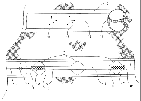
field sources.With reference to Fig. 5A, an embodiment of a magnetic ranging
system and method comprises a magnetic transmitter assembly or solenoid
assembly 3 positioned within a target, or first borehole 2, located in a
previously-
drilled formation 1. The transmitter assembly comprises dual magnetic field
sources
comprising first and second solenoids 6, 7. The first solenoid 6 forms the
first
magnetic field source and the second solenoid forms the second magnetic field
source.
14
CA 02815877 2013-05-14
The solenoids 6,7 are rigidly spaced apart at a known and fixed
distance by a non-magnetic, interconnecting member or rigid solenoid spacer 8.
An
exemplary arrangement includes solenoids 6,7 which are each 2.5m in length and
the rigid solenoid spacer 8 is 7.5m in length. Each solenoid 6,7 has pole ends
El ,E2 and E3,E4 respectively, the dimension between which is also known.
Accordingly, the axial spacing or dimensions of the solenoid assembly 3 are
known.
The solenoids 6,7 are preferably identical.
A drilling assembly 11 incorporating a measurement while drilling
(MWD) tool 12 is located in an adjacent and second borehole 10 which is in the
process of being drilled. The MWD tool 12 comprises at least a three-axis
magnetic
sensor, detector or magnetometer 13. The drilling assembly further comprises
conventional circuitry for receiving and transmitting drilling information
signals or
steering data from the surface for drilling of the second borehole relative to
the first
borehole. There are a number of ways the MWD can be located in the second
borehole. The MWD can be located by a drill string or by coiled tubing. The
drill
string can be rotated for driving a drill bit, or stationary, being fit with a
mud motor for
drilling.
The first borehole is drilled and its path recorded using standard
borehole surveying methods such as measurement while drilling surveys. The
coordinates of the magnetometer 13 of the MWD tool 12 are recorded. During
operation the MWD tool 12 is deployed in the adjacent and second borehole 10
which is being drilled in a specified, relative, geometrical relationship to
the first
CA 02815877 2013-05-14
borehole 2. A ranging procedure or survey is initiated when the MWD 12 is
rotationally stationary. The MWD 12 and the magnetometer 13 can be held
substantially and rotationally stationary while drilling, or drilling can be
stopped so as
to render the magnetometer 13 rotationally stationary. If the MWD 12 is
located at
the end of a rotating drill string, drilling would have to be stopped, before
the survey
is started, for holding the magnetometer 13 rotationally stationary. Stopping
drilling
comprises stopping rotation of a rotating drill string from the surface.
However, if the
MWD 12 is located at the end of a non-rotating coiled tubing or drill string
fit with a
mud motor, the MWD 12 would already be substantially and rotationally
stationary
and, therefore, drilling would not necessarily have to be stopped before
starting the
survey. As used herein, substantially stationary, means the MWD is not
rotating but
could still have lateral displacement along the second borehole. Conveniently,
a
ranging procedure can occur when stopping drilling for insertion of another
pipe
stand. The results of the ranging procedure are used to guide incremental
drilling.
In other embodiments, the steering data or the distance, direction and
orientation can be determined by a processor located downhole or at the
surface.
The solenoid assembly or magnetic transmitter assembly 3 is deployed or
conveyed
into the first borehole 2 and is connected by wireline 4 to a controlling
surface unit
(not shown). For conducting measurements, the solenoid assembly 3 is
positioned
in the first borehole 2 such that the midpoint of the solenoid spacer 8, being
midpoint
between the solenoids 6,7, is approximately opposite coordinates of the
magnetometer 13 of the MWD tool 12 in the second borehole 10. The first
solenoid
16
CA 02815877 2013-05-14
6 and the second solenoid 7 are sequentially energized for generating measured
components of the first and second magnetic flux densities recorded at the
magnetometer 13. In one embodiment, the solenoid assembly 3 is energised by
passing DC current in each of a first and a second direction for a duration of
3-10
seconds.
As the second borehole can be at angle relative to the first borehole, a
reference to approximately opposite or opposite the magnetometer means as near
to a point of closest proximity thereto, understanding that midpoint of the
solenoid
assembly 3 may be oriented alongside each other or at an angle to about
perpendicular to the magnetometer 13. The solenoid assembly 3 is positioned at
a
known depth in the first borehole 2 such as by using a downhole tractor 5.
Centralizers 9 are used to centralize the solenoid assembly 3 in the first
borehole 2.
As shown in Figs. 5A and 5B, the solenoids and magnetometer can
reside in boreholes that are side by side. Further, in one example shown in
Fig. 5C
and as a result of embodiments of the present invention, the boreholes may
also be
at any angle relative to each other.
The first and second solenoids 6,7 are controllable magnetic field
sources which are sequentially energized for producing magnetic fields, the
magnetic flux densities of which can be measured by the magnetometer 13. The
activating the dual magnetic field sources is through a sequential process of
energizing the first solenoid 6 and measured components of a first magnetic
flux
density measured by the magnetometer 13, and energizing the second solenoid 7
17
CA 02815877 2013-05-14
and measured components of a second magnetic flux density measured by the
magnetometer. The measured components are collected such as by recording.
Some of the challenges with use of magnetic fields and ranging
between boreholes include compensating for the solenoid fields themselves and
use
of casing which is subject to being magnetized by the magnetic survey.
In embodiments of the invention, the magnetic field sources are slowly
switched fields between positive and negative states. A square wave field can
be
operated at a low frequency approximating a slowly varying alternating current
at
frequencies less than 1 Hz. An example of frequency is in the order of 2
cycles per
minute.
The measurement used in the ranging calculations is due to the
solenoid field alone. Constant field effects, such as the earth's magnetic
field, may
be calculated and subsequently eliminated by obtaining the average of both
positive
and negative magnetic flux data from the magnetic field sources. The constant
fields may then be eliminated by subtracting them from measurements made when
the solenoids are energized.
Alternatively, one can eliminate constant field effects by obtaining
energized magnetic flux data, obtaining de-energized magnetic flux data and
taking
the difference. Positive and negative magnetic flux data avoids inaccuracies
that
can be introduced where the first borehole is a cased borehole and the casing
becomes magnetized. Accordingly, caution is to be used with magnetized casing.
Magnetization errors may be reduced by demagnetizing the casing between
18
CA 02815877 2013-05-14
measurements or by measuring the magnetic flux data including that due to the
magnetized casing with the solenoid off. Either way, the constant field data
is
subtracted from the magnetic flux data so as to obtain the solenoid
measurement
data.
In one approach, the first solenoid 6 is activated in a first polarity by an
activation current in a first direction. Energizing of the activation current
is initiated
by wireline 4. The MWD tool is 12 then signalled from the surface to take a
survey
and record orthogonal Cartesian components or measured components of the
magnetic flux density vector B1+ = (B1x+, B1y+, B1z+) using magnetometer 13.
Note that "1" in the notation indicates the magnetic flux density measured
when the
first solenoid 6 is turned on, the second solenoid is off, and the plus sign
"+" in the
notation is to indicate a first polarity.
The polarity of the first solenoid 6 is then put into an equal but opposite
state by reversing the activation current and another survey is taken to
obtain the
three component vector B1- = (B1x-, B1y-, B1z-), where the minus sign "-"
indicates
the second or opposite polarity state of the solenoid.
After the magnetic flux density vectors B1+, and B1- are obtained, the
first solenoid 6 is then turned off.
The second solenoid 7 is then energized and the same procedure is
followed as with the first solenoid resulting in magnetic flux density vector
B2+ =
(B2x+, B2y+, B2z+) and magnetic flux density vector B2- = ( B2x-, B2y-,B2z-),
where
19
CA 02815877 2013-05-14
the 2 in the notation indicates magnetic flux density measurements obtained
when
the second solenoid 7 is turned on, and the first solenoid 6 is turned off.
When within about 10 meters of magnetized casing, magnetometer
data can be compromised. Optionally, such as in instances in which the first
borehole 2 is cased, a procedure includes demagnetizing the casing. The first
solenoid 6 and surrounding casing are demagnetized using a conventional
methodology of applying decreasing oscillating current to the first solenoid
6. In this
way errors associated with residual magnetism from the first solenoid 6 and
surrounding casing are minimized or avoided in subsequent measurements made
when the second solenoid 7 is activated. The term "off" as it is used herein
refers to
a state in which the voltage (and current) to a solenoid is zero and, as
appropriate,
when the solenoid and surrounding casing have been demagnetized.
A measurement of the orientation of the MWD tool 12, and therefore
the magnetometer 13, relative to the gravity vector (tool face angle and
inclination
measurement), can also done using a three-axis accelerometer sensor 14 for
measuring three-axis acceleration data relative to the earth's coordinate
system.
For ease of data reduction the axes of the accelerometer sensor 14 and
magnetometer 13 are aligned; i.e. (x,y,z) directions are the same for both
instruments. The tool face angle is used to mathematically rotate the
magnetometer
measurements as if the X-axis is vertical up. Accordingly, the direction in
the tool's
X-Y plane to the target borehole is oriented in the earth's coordinate system.
We
CA 02815877 2013-05-14
can now display the X-Y plane projection of the vector between the
magnetometer
and the solenoid assembly relative to gravity.
The acceleration data is telemetered to the surface along with the six
magnetometer measurements or, alternatively, the tool face rotation is done
downhole and corrected magnetometer measurements are telemetered to the
surface.
Fig. 3 illustrates the steps for measurement of the magnetic field
generated by energisation of the magnetic sources in a conventional magnetic
ranging method described in Kuckes and Clark.
Prior art measurement steps are subject to delays as illustrated in Fig.
3 of the drawings. The measurement steps in the prior art are as follows:
start drilling
of the second borehole (301); the drilling is stopped (block 302); the
solenoid
assembly pr magnetic transmitter assembly is energised (block 303); the MWD
including the detector or three-axis magnetometer detects that drilling has
stopped
and activates the detector (block 304); the detector waits a first delay
(block 305)
before measuring the various components of the magnetic field; the detector
compares the measured value with a reference value stored therein (block 306)
to
identify solenoid activity and transmits the value to the surface if solenoid
activity is
identified; and a corrective course is charted using the measured values
(block 307).
Delays are introduced when the MWD waits for a preset period of time before
measuring (block 305) the magnetic field and when the measured values are
21
CA 02815877 2013-05-14
compared with a reference value to determine whether the reference value is a
solenoid related value (block 305).
Herein, delays are eliminated through synchronicity of magnetometer
and the solenoid assembly. Thus, survey duration is also reduced. The
measurement steps according to one embodiment are illustrated in Fig. 4 of the
accompanying drawings. One starts drilling of the second borehole (block 401).
For
a rotating drill string, drilling is stopped (block 402) for holding the three-
axis
magnetometer 13 rotationally stationary. Survey is started by synchronising
triggering of the three-axis magnetometer 13 (block 403) and energisation of
the
magnetic transmitter assembly or solenoid assembly 3 (block 404). The solenoid
assembly 3 is energised by passing DC current in each direction for about 10
seconds. This enables measurement and recordation of various components of the
alternating magnetic field by the three-axis magnetometer 13 as soon as the
solenoid assembly 3 is energised (block 405). As the triggering and the
energisation
is synchronised there is no uncertainty that the magnetic field being measured
by
the magnetometer is indeed that of the solenoid assembly 3. Therefore, the
verification process and delay due to the verification process are eliminated.
Since
measurement starts the moment the solenoid assembly 3 is energised, the values
of
the magnetic field are recorded before the magnetic field falls off.
Synchronicity also
reduces the survey time as the DC current is passed in each of a first
direction and
then a second direction only for about 10 seconds. The values being recorded
are
also error free as the probability of the MWD 12 including the three-axis
22
CA 02815877 2013-05-14
magnetometer 13 vibrating during the about 20 or so seconds (duration of the
survey) is minimized. The measured or recorded values are transmitted to the
surface, such as via EM telemetry (block 406) for computation of steering data
for
drilling the second borehole relative to the first borehole.
EM telemetry can be implemented through a variety of techniques. In
one technique, electromagnetic signals are modulated according to a sensor
response to represent one or more components of interest. These signals are
detected by either a downhole EM transceiver or a surface EM transceiver at
the
surface. Using another EM telemetry technique, a current is created within the
drill
string and the current is modulated according to the sensor response to
represent
the one or more components of interest.
EM telemetry also results in faster data collection at the surface. The
steering data or corrective course can also be computed downhole.
Figs. 4A and 4B illustrate a system 501 for reducing delays according
to another embodiment by triggering the three-axis magnetometer 13 using EM
telemetry synchronous with energizing the magnetic transmitter assembly 3 from
.
surface using a survey system 502. The survey system 502 is located at the
surface.
The magnetic field components measured by the magnetometer 13 are either
transmitted to a processor 504 which is either located downhole (Fig.4A) or at
the
surface (Fig.4B) for calculation or computation of steering data. Depending on
where
the steering data is calculated, the steering data is communicated to the MWD
12 by
the processor 504 or the survey system 502.
23
CA 02815877 2013-05-14
In one embodiment, synchronisation is achieved by initiating the
energizing of the magnetic transmitter assembly 3 by wireline and triggering
the
three-axis magnetometer 13 from the surface using EM telemetry. As the delays
in
the measurement process are substantially eliminated, drilling progresses at
the set
rate.
The data, being recorded measured values or recorded measured
components, is processed by the processor or computer 504, typically at
surface,
using a successive approximation technique to determine the range, and
orientation
of the borehole being drilled relative to the target borehole (block 406). The
data
analysis comprises combining the known spacer distance and measured
components of the first and second magnetic flux densities using successive
approximation inversion to produce the distance, the direction, and the
orientation of
the second borehole relative to the first borehole. Steering data, for
drilling the
second borehole relative to the first borehole, is determined using the
recorded,
measured components of the alternating magnetic fields.
If the processor 504 is located at the surface, the recorded
components of the alternating magnetic field can be transmitted to surface
through
EM telemetry, between the downhole and surface EM transceivers. EM telemetry
could be conducted while drilling i.e. survey is started while drilling. The
determined
steering data is then transmitted downhole by the survey system 502 via EM
telemetry for drilling the second borehole relative to the first borehole.
Here, for a
24
CA 02815877 2013-05-14
short period of time, the second borehole is drilled without using the
determined
steering data.
The survey can also be started after drilling is stopped for better
ensuring the magnetometer rotationally stationary 18. In this case, the second
borehole is drilled at all times using the determined steering data. Here, the
drilling is
stopped, the survey is started and the recorded components of the alternating
magnetic field are transmitted to the surface using EM telemetry for
determining the
steering data at the surface. The determined steering data are transmitted
downhole
via EM telemetry, and the second borehole is drilled relative to the first
borehole
using the determined steering data.
The steering data is used to steer the drilling of the second borehole
such that it is in a prescribed relative geometric relationship to the target
borehole.
The relative geometric relationship can be, but is not limited to, a parallel
borehole at
a specified distance and direction from the target borehole. In the processing
the
differences between magnetometer measurements in the plus (+) and minus (-)
states are taken to eliminate influences of constant fields such as the
earth's field
and fields from magnetized metals such as casings, and to therefore have a
measure of only the solenoid fields. Advantage may be taken of this to reduce
the
number of magnetometer measurements transmitted to the surface by 1/2 by
taking
these differences downhole before transmission to the surface.
CA 02815877 2013-05-14
Accordingly, the second borehole 10 with the MWD tool 12 is drilled
and steered a desired distance and direction from the first borehole 2 by
using the
distance, direction, and orientation calculations.
Fig. 6A shows a depiction of the solenoid assembly 3 in the first
borehole and the MWD tool magnetometer 13 depicted by an orthogonal xyz axis
set. The individual solenoids 6, 7 are represented by a magnetic pole strength
Q at
or near the pole ends El through E4 of each solenoid Q1 through Q4. The pole
strength Q is in Webers and is calculated as the area of the solenoid times
the
magnetic flux density at the ends of the solenoids.
Q= 13=A
Vectors RO, R1, R2, R3 and R4 from the solenoid assembly to the
magnetometer represent the distance and direction from the center of the
solenoid
assembly to the magnetometer (RO) and the vectors (R1 through R4) from each of
the magnetic pole ends El - E4 to the magnetometer 13. The vectors
representing
the positions of the magnetic poles are represented as Si through S4. Since
the
solenoids are part of a rigid assembly having the known spacer distance, the S
vectors are parallel. The S vectors are the distance and direction from the
center of
the solenoid assembly to each corresponding magnetic pole E1-E4. Accordingly,
S1
= plus R1 is equal to RO. Similarly, S4 plus R4 is equal to RO, and so on.
The
magnitudes of S1 ¨ S4 are known as they are now known dimensions of the
26
CA 02815877 2013-05-14
solenoid assembly 3 of the present invention. The distance and direction
vector RO
is solved for through inversion using known standard iterative techniques. At
the
same time the relative direction angles of the magnetometer and the axis of
the
solenoid assembly are computed. Fig. 4A shows the solenoid axis vector in the
frame of the magnetometer. The spherical polar angles 6 and (1) give the
relative
orientation of the magnetometer and solenoid respectively.
If the pole separation (El ,E2 and E3,E4) on each identical solenoid is
Sps (slightly less than the solenoid lengths), and if the distance between the
centers
of the solenoids is Sss, then the unit direction vector of the solenoid
assembly in the
frame of the magnetometer is
( sin(0) cos (0)
Us(0 , (0) = sin(0) sin(0)
cos (0)
where 0 and 0:1:0 are the spherical polar coordinate angles in the frame
of the magnetometer, then the vectors S1 through S4 can be expressed as:
Sss Sps
S1=Us(0,?)=(¨+) ¨
2 2
Sss Sps)
S4 =Us(0,gq =(¨ --
2 2
27
CA 02815877 2013-05-14
S3 = Us(0,0).(_Sss +Sps
2 2
Sss Sps
S4=Us(0,0)=(-2 --)2
The magnetic intensity vector B from each magnetometer reading
without the influence of static fields is:
B1 = (B1+ - B1-)/2
where
B1+ = (B1x+, B1y+, B1z+)
B1- = (B1x-, B1y-, Blz-)
and
B2 = (B2+ - B2-)/2
where
B2+ = (B2x+, B2y+, B2z+)
B2- = (B2x-, B2y-, B2z-)
61 and 132 may now be derived in terms of the components of the
solenoid and the vector from the solenoid S to the magnetometer 13.
_
, Sss Sps
RO ¨ Uske , 0. ( ¨ +) ¨i µ Sss
Sps
RO ¨ Usk AI. (¨ ¨ --) -
Q 2 2 2 2
B1=¨=
4.a 3 3
Ss; + _Sii_s IRO ¨ Us(8 )1]( s .2
¨Its
¨
_
28
CA 02815877 2013-05-14
Sss Sps
A. + ¨ Sss Sps
RO ¨ Us(0 ¨ ¨)
Qk RO ¨ Us(0v
2 2 2 2
B2=
4.7r \. _Sss Sps)1-13 µ. _Sss
Sps
All of the variables in the above equations have been defined
previously defined except k which is the relative strength of second solenoid
7
relative to first solenoid 6. This parameter is either measured at the surface
or
calculated when the solenoids are downhole in the first borehole 2. The
solenoid
assembly components of Sss and Sps are also known.
For the inversion, B1 and B2 are first measured (six measured
components). Then RO, Q the pole strength, and (6 , (D) the direction angles
of the
solenoid (a total of six measurements) are solved for. The solution of these
six
equations and six unknowns has no closed form solution, therefore an iterative
technique must be used. The inversion is performed by one or more well known
standard iterative techniques such as Levenberg-Marquardt or a Gauss-Newton
method. The vector, RO, and the unit direction vector of the solenoid
assembly,
Us(0 ,41)), are the required distance, direction, and orientation of the
second borehole
10 relative to the first borehole 2. As a further step RO and Us(e ,O) can
also be
transformed in a standard way by using inclination and tool-face information
from the
accelerometer sensor whose axes are aligned with the magnetometer to display
the
relative position of the two boreholes referenced to the gravity vector.
29
CA 02815877 2013-05-14
By virtue of the solenoids 6,7 being interconnected by the solenoid
spacer 8, the distance therebetween is known precisely.
Previously, errors in measuring this distance, such as that introduced
by the prior art moving a single solenoid an approximate distance between two
positions, translates directly into an error in range calculation. For
example, as set
forth in the prior art patent US '089 to Kuckes, at equation 10, Kuckes
describes the
"best way" to determine the distance r between two boreholes. Reproduced
therein,
equation 10 from Kuckes:
z, - z2
r= ____________________
a - a2
where
r is the range between the two boreholes and zl and z2 are two
chosen depth locations for a single solenoid, and
in the denominator al and a2 are functions of the magnetic field
measurements at the two chosen depth locations.
Kuckes advises that a suitable application of the above is when the
depths are chosen such that the alphas are approximately 0.3. In this case
Kuckes' equation 10 reduces to:
z, - z,
r=
0.6
Therefore an error measuring zl-z2 translates to an error in r of 1/0.6
or 1.66 times the error made in zl-z2. The error results from inaccuracies in
determining the depth or distance between the two depth locations for the
solenoid.
CA 02815877 2013-05-14
Typical applications for magnetic ranging is in horizontal boreholes in
which the solenoid assembly 3 is conveyed in the first borehole 2 with a
borehole
tractor 5 and the depth is measured by a wireline cable played out from the
surface,
and the depth is usually inferred from an encoder wheel (not shown) on the
wireline
cable. Not required herein, measurement errors between two solenoid positions
can
occur in the prior art method due to slippage of the encoder wheel and stretch
of the
wireline cable under varying tension. The prior art is susceptible to such
errors and
results in errors in the estimation of range.
In embodiments of the invention, a further advantage to the two
spaced solenoids 6,7, six measurement technique, is that there is no need to
assume that the second borehole 10 being drilled is parallel to the target,
first
borehole 2. In addition to determining the distance between the two boreholes
10,2,
and the direction of one borehole relative to the other, the present invention
determines the relative orientation of the two boreholes, and does not assume
that
the two boreholes are parallel. Still further, embodiments of the present
invention do
not assume the individual solenoids to be point dipoles but, rather, as two
pole ends
El ,E2 and E3,E4 or two magnetic poles separated by the length of the
solenoid. At
distances which are large, with respect to the length of the solenoid, the
point dipole
approximation used by previous ranging techniques yields acceptable results,
but,
when the range to be determined is not large with respect the solenoid length
the
separated pole model is much better.
31
CA 02815877 2013-05-14
Fig. 7 shows a preferred embodiment of the solenoid assembly 3 in a
cased borehole which affords a more accurate location of the separated poles.
In
this embodiment magnetically permeable end caps or end pieces 16 are placed on
the ends of each solenoid 6,7 to conduct the magnetic flux to a more precise
location on the casing around the solenoid. These end pieces 16,16,16,16 are
magnetically connected to the solenoid ends and are of a larger diameter than
the
solenoid itself so that the air gap between the solenoid ends and the casing
is
reduced or minimised. The result is that the location of the magnetic pole as
seen
from outside the casing is not "smeared" as much as several feet as it is with
a
solenoid with no end pieces.
Further, direct measurement of the pole positions can be made at
surface, outside of the borehole. The solenoid assembly 3 can be placed in a
piece
of representative casing and a gauss meter is used to find the location of the
poles
E1-E4 by moving the probe of the gauss meter along the outside of the
representative casing, finding maxima, and measuring the distance between
maxima
to obtain Sss.
32