Note: Descriptions are shown in the official language in which they were submitted.
CA 02819165 2013-05-27
WO 2012/106211
PCT/US2012/022971
EXPLOITATION OF SELF-CONSISTENCY AND DIFFERENCES
BETWEEN VOLUME IMAGES AND INTERPRETED
SPATIAL/VOLUMETRIC CONTEXT
CROSS-REFERENCE TO RELATED APPLICATIONS
[001] This application claims priority to U.S. Patent Application Serial Nos.
13/018,094,
13/018,108 and 13/018,122 all with a filing date of January 31, 2011.
FIELD OF THE DISCLOSURE
[002] This disclosure relates to improving seismic imaging and estimation of
attributes
and/or rock properties of geobodies by exploiting self-consistency and/or
differences between
volume images and interpreted spatial/volumetric context.
BACKGROUND OF THE DISCLOSURE
[003] Seismic imaging and subsurface interpretation are performed to obtain,
as accurately
as possible, a geologic model of a subsurface volume of the earth.
Conventional industry
workflows generally include the following serial process steps: (a) process
the seismic data
into 3D seismic image volumes of the subsurface volume of the earth; (b)
extract attributes
(e.g., velocity, Poisson's ratio, density, acoustic impedance, etc.) at each
subsurface point in
the subsurface volume of the earth using tabulated and other known
petrophysical data and
rock properties; (c) interpret the geometry of the 3D seismic image volumes,
log information,
and geological analogs on an interpretation workstation to obtain the
structure, stratigraphic,
and geologic morphology; and (d) construct a geological and reservoir
subsurface model
from extracted attributes and the obtained structure, stratigraphic, and
geologic morphology.
[004] Conventional industry workflows have limited reconciliation/integration
of earth
models used in imaging with interpretation of structure and stratigraphy, and
with reservoir
1
CA 02819165 2013-05-27
WO 2012/106211
PCT/US2012/022971
properties from seismic estimation. Each process step has inherent
uncertainties and non-
uniqueness that cannot be well defined quantitatively. Consequently, it is
difficult to quantify
the uncertainties and non-uniqueness of geological reservoir models yielded by
conventional
industry workflows. Most industry workflows resort to geostatistical methods
to estimate
uncertainties and non-uniqueness. Even so, there is no guarantee that the
resulting,
probabilistic models are consistent with all the data utilized in generating
the models.
SUMMARY
[004] One aspect of the disclosure relates to a computer-implemented method
for exploiting
positional and/or shape discrepancies and/or similarities of geobodies in
image volumes
associated with earth models of a geologic volume of interest to improve the
accuracy of the
earth models, velocity models used for pre-stack imaging, and/or the image
volumes. The
method may include obtaining a velocity model and/or an earth model from
seismic data
representing energy that has propagated through the geologic volume of
interest from one or
more energy sources to one or more energy receivers. The seismic data may
include one or
more of a plurality of offset stacks, a plurality of angle stacks, or a
plurality of azimuth
stacks. The method may include obtaining a plurality of multi-offset-multi-
attribute image
volumes from the seismic data. A given one of the multi-offset-multi-attribute
image
volumes may (1) correspond to one of the offset stacks, angle stacks, or
azimuth stacks, (2)
be associated with at least one attribute, and (3) include geobody
representations of geobodies
present in the geologic volume of interest. The method may include receiving
geobody
interpretations based on the multi-offset-multi-attribute image volumes. The
geobody
interpretations may include identified geobodies having geobody
representations in the multi-
offset-multi-attribute image volumes and geobody types assigned to the
identified geobodies.
The method may include obtaining registration data associated with individual
identified
geobodies in different ones of the multi-offset-multi-attribute image volumes
based on the
2
CA 02819165 2013-05-27
WO 2012/106211
PCT/US2012/022971
assigned geobody types. The registration data for a given geobody may
represent a spatial
position, a shape of the given geobody, and/or discrepancies and/or
similarities between
geobody representations of the given geobody in different ones of the multi-
offset-multi-
attribute image volumes. The method may include updating the earth model
and/or the
velocity model using travel time inversion techniques based on the
registration data and the
assigned geobody types. The method may include generating updated multi-offset-
multi-
attribute image volumes based on the updated earth model and/or the updated
velocity model.
[005] Another aspect of the disclosure relates to a system configured to
exploit positional
and/or shape discrepancies and/or similarities of geobodies in image volumes
associated with
earth models of a geologic volume of interest to improve the accuracy of the
earth models,
velocity models used for pre-stack imaging, and/or the image volumes. The
system may
include one or more processors configured to execute computer program modules.
The
computer program modules may include a model module, an imaging module, a
geobody
interpretation module, and/or other modules. The model module may be
configured to obtain
a velocity model and/or an earth model from seismic data representing energy
that has
propagated through the geologic volume of interest from one or more energy
sources to one
or more energy receivers. The seismic data may include one or more of a
plurality of offset
stacks, a plurality of angle stacks, or a plurality of azimuth stacks. The
imaging module may
be configured to obtain a plurality of multi-offset-multi-attribute image
volumes from the
seismic data. A given one of the multi-offset-multi-attribute image volumes
may (1)
correspond to one of the offset stacks, angle stacks, or azimuth stacks, (2)
be associated with
at least one attribute, and (3) include geobody representations of geobodies
present in the
geologic volume of interest. The geobody interpretation module may be
configured to
receive geobody interpretations based on the multi-offset-multi-attribute
image volumes. The
geobody interpretations may include identified geobodies having geobody
representations in
3
CA 02819165 2013-05-27
WO 2012/106211
PCT/US2012/022971
the multi-offset-multi-attribute image volumes and geobody types assigned to
the identified
geobodies. The geobody interpretation module may be further configured to
obtain
registration data associated with individual identified geobodies in different
ones of the multi-
offset-multi-attribute image volumes based on the assigned geobody types. The
registration
data for a given geobody may represent a spatial position, a shape of the
given geobody,
and/or discrepancies and/or similarities between geobody representations of
the given
geobody in different ones of the multi-offset-multi-attribute image volumes.
The model
module may be further configured to update the earth model and/or the velocity
model using
travel time inversion techniques based on the registration data and the
assigned geobody
types. The imaging module may be further configured to generate updated multi-
offset-
multi-attribute image volumes based on the updated earth model and/or the
updated velocity
model.
[006] Yet another aspect of the disclosure relates to a computer-readable
medium having
instructions embodied thereon. The instructions may be executable by a
processor to perform
a method for exploiting positional and/or shape discrepancies and/or
similarities of geobodies
in image volumes associated with earth models of a geologic volume of interest
to improve
the accuracy of the earth models, velocity models used for pre-stack imaging,
and/or the
image volumes. The method may include obtaining a velocity model and/or an
earth model
from seismic data representing energy that has propagated through the geologic
volume of
interest from one or more energy sources to one or more energy receivers. The
seismic data
may include one or more of a plurality of offset stacks, a plurality of angle
stacks, or a
plurality of azimuth stacks. The method may include obtaining a plurality of
multi-offset-
multi-attribute image volumes from the seismic data. A given one of the multi-
offset-multi-
attribute image volumes may (1) correspond to one of the offset stacks, angle
stacks, or
azimuth stacks, (2) be associated with at least one attribute, and (3) include
geobody
4
CA 02819165 2013-05-27
WO 2012/106211
PCT/US2012/022971
representations of geobodies present in the geologic volume of interest. The
method may
include receiving geobody interpretations based on the multi-offset-multi-
attribute image
volumes. The geobody interpretations may include identified geobodies having
geobody
representations in the multi-offset-multi-attribute image volumes and geobody
types assigned
to the identified geobodies. The method may include obtaining registration
data associated
with individual identified geobodies in different ones of the multi-offset-
multi-attribute image
volumes based on the assigned geobody types. The registration data for a given
geobody
may represent a spatial position, a shape of the given geobody, and/or
discrepancies and/or
similarities between geobody representations of the given geobody in different
ones of the
multi-offset-multi-attribute image volumes. The method may include updating
the earth
model and/or the velocity model using travel time inversion techniques based
on the
registration data and the assigned geobody types. The method may include
generating
updated multi-offset-multi-attribute image volumes based on the updated earth
model and/or
the updated velocity model.
[007] These and other features and characteristics of the present technology,
as well as the
methods of operation and functions of the related elements of structure and
the combination
of parts and economies of manufacture, will become more apparent upon
consideration of the
following description and the appended claims with reference to the
accompanying drawings,
all of which form a part of this specification, wherein like reference
numerals designate
corresponding parts in the various figures. It is to be expressly understood,
however, that the
drawings are for the purpose of illustration and description only and are not
intended as a
definition of the limits of the technology. As used in the specification and
in the claims, the
singular form of "a", "an", and "the" include plural referents unless the
context clearly
dictates otherwise.
CA 02819165 2013-05-27
WO 2012/106211
PCT/US2012/022971
BRIEF DESCRIPTION OF THE DRAWINGS
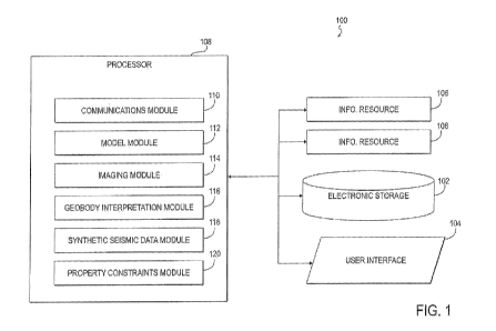
[008] FIG. 1 illustrates a system configured to improve seismic imaging and
estimation of
attributes and/or rock properties of geobodies by exploiting self-consistency
and/or
differences between volume images and interpreted spatial/volumetric context,
in accordance
with one or more embodiments.
[009] FIG. 2 illustrates a method for improving seismic imaging and estimation
of attributes
and/or rock properties of geobodies by exploiting self-consistency and/or
differences between
volume images and interpreted spatial/volumetric context, in accordance with
one or more
embodiments.
DETAILED DESCRIPTION
[0010] The present technology may be described and implemented in the general
context of a
system and computer methods to be executed by a computer. Such computer-
executable
instructions may include programs, routines, objects, components, data
structures, and
computer software technologies that can be used to perform particular tasks
and process
abstract data types. Software implementations of the present technology may be
coded in
different languages for application in a variety of computing platforms and
environments. It
will be appreciated that the scope and underlying principles of the present
technology are not
limited to any particular computer software technology.
[0011] Moreover, those skilled in the art will appreciate that the present
technology may be
practiced using any one or combination of hardware and software
configurations, including
but not limited to a system having single and/or multi-processer computer
processors system,
hand-held devices, programmable consumer electronics, mini-computers,
mainframe
computers, and the like. The technology may also be practiced in distributed
computing
environments where tasks are performed by servers or other processing devices
that are
6
CA 02819165 2013-05-27
WO 2012/106211
PCT/US2012/022971
linked through one or more data communications networks. In a distributed
computing
environment, program modules may be located in both local and remote computer
storage
media including memory storage devices.
[0012] Also, an article of manufacture for use with a computer processor, such
as a CD, pre-
recorded disk or other equivalent devices, may include a computer program
storage medium
and program means recorded thereon for directing the computer processor to
facilitate the
implementation and practice of the present technology. Such devices and
articles of
manufacture also fall within the spirit and scope of the present technology.
[0013] Referring now to the drawings, embodiments of the present technology
will be
described. The technology can be implemented in numerous ways, including for
example as
a system (including a computer processing system), a method (including a
computer
implemented method), an apparatus, a computer readable medium, a computer
program
product, a graphical user interface, a web portal, or a data structure
tangibly fixed in a
computer readable memory. Several embodiments of the present technology are
discussed
below. The appended drawings illustrate only typical embodiments of the
present technology
and therefore are not to be considered limiting of its scope and breadth.
[0014] FIG. 1 illustrates a system 100 configured to improve seismic imaging
and estimation
of attributes and/or rock properties of geobodies by exploiting self-
consistency and/or
differences between volume images and interpreted spatial/volumetric context,
in accordance
with one or more embodiments. More specifically, the system 100 may be
configured to
exploit positional and/or shape discrepancies and/or similarities of geobodies
in image
volumes associated with earth models of a geologic volume of interest to
improve the
accuracy of the earth models, velocity models used for pre-stack imaging,
and/or the image
volumes. In some embodiments, the system 100 may be configured to constrain a
range of
rock properties and confirm and/or specify dependencies between rock
properties of
7
CA 02819165 2013-05-27
WO 2012/106211
PCT/US2012/022971
geobodies associated with the geologic volume of interest. The system 100 may
be
configured to construct an earth model using multi-offset-multi-attribute
image volumes and
identified geobodies associated with a geologic volume of interest, according
to some
embodiments. Seismic data may be re-imaged with an updated model.
[0015] A geologic volume of interest may include one or more "overburdens." An
overburden may generally be described as a geologic section above a bed,
refractor, and/or
reflector. Examples of an overburden may include material lying above an ore
or valuable
deposit and pressing down on it, loose unconsolidated material above bedrock,
and/or other
overburdens. An overburden may be associated with a velocity model and/or
other model
that can be used for re-imaging.
[0016] A geologic volume of interest may include one or more targets such as,
for example,
reservoir targets. Detailed analysis may be performed on such targets to
determine
information relating to geobodies and/or rock properties, in accordance with
one or more
embodiments. Depending on the specific information sought, a geologic volume
of interest
may include an entire geologic section from the surface to the target interval
over an area of
interest, or a geologic volume of interest may be confined to a specific
target interval.
[0017] As depicted in FIG. 1, the system 100 may include electronic storage
102, a user
interface 104, one or more information resources 106, at least one processor
108, and/or other
components. In some embodiments, the electronic storage 102 comprises
electronic storage
media that electronically stores information. The electronic storage media of
the electronic
storage 102 may include system storage that is provided integrally (i.e.,
substantially non-
removable) with the system 100 and/or removable storage that is removably
connectable to
the system 100 via, for example, a port (e.g., a USB port, a firewire port,
etc.) or a drive (e.g.,
a disk drive, etc.). The electronic storage 102 may include one or more of
optically readable
storage media (e.g., optical disks, etc.), magnetically readable storage media
(e.g., magnetic
8
CA 02819165 2013-05-27
WO 2012/106211
PCT/US2012/022971
tape, magnetic hard drive, floppy drive, etc.), electrical charge-based
storage media (e.g.,
EEPROM, RAM, etc.), solid-state storage media (e.g., flash drive, etc.),
and/or other
electronically readable storage media. The electronic storage 102 may store
software
algorithms, information determined by the processor 108, information received
via the user
interface 104, information received from the information resources 106, and/or
other
information that enables the system 100 to function as described herein. The
electronic
storage 102 may be a separate component within the system 100, or the
electronic storage
102 may be provided integrally with one or more other components of the system
100 (e.g.,
the processor 108).
[0018] The user interface 104 is configured to provide an interface between
the system 100
and a user through which the user may provide information to and receive
information from
the system 100. This enables data, results, and/or instructions and any other
communicable
items, collectively referred to as "information," to be communicated between
the user and the
system 100. As used herein, the term "user" may refer to a single individual
or a group of
individuals who may be working in coordination. Examples of interface devices
suitable for
inclusion in the user interface 104 include one or more of a keypad, buttons,
switches, a
keyboard, knobs, levers, a display screen, a touch screen, speakers, a
microphone, an
indicator light, an audible alarm, and/or a printer. In one embodiment, the
user interface 104
actually includes a plurality of separate interfaces.
[0019] It is to be understood that other communication techniques, either hard-
wired or
wireless, are also contemplated by the present technology as the user
interface 104. For
example, the present technology contemplates that the user interface 104 may
be integrated
with a removable storage interface provided by the electronic storage 102. In
this example,
information may be loaded into the system 100 from removable storage (e.g., a
smart card, a
flash drive, a removable disk, etc.) that enables the user to customize the
implementation of
9
CA 02819165 2013-05-27
WO 2012/106211
PCT/US2012/022971
the system 100. Other exemplary input devices and techniques adapted for use
with the
system 100 as the user interface 104 include, but are not limited to, an RS-
232 port, RF link,
an IR link, modem (telephone, cable or other). In short, any technique for
communicating
information with the system 100 is contemplated by the present technology as
the user
interface 104.
[0020] The information resources 106 include one or more sources of
information related to
the geologic volume of interest. By way of non-limiting example, one of
information
resources 106 may include seismic data acquired at or near the geological
volume of interest,
information derived therefrom, and/or information related to the acquisition.
Such seismic
data may include source wavefields and receiver wavefields. The seismic data
may include
individual traces of seismic data (e.g., the data recorded on one channel of
seismic energy
propagating through the geological volume of interest from a source), offset
stacks, angle
stacks, azimuth stacks, and/or other data. The information derived from the
seismic data may
include, for example, geologic models from seismic data representing energy
that has
propagated through the geologic volume of interest from one or more energy
sources to one
or more energy receivers, image volumes from the geologic model representing
geobodies
present in the geologic volume of interest, and/or other information.
Individual ones of the
image volumes may correspond to individual ones of the offset stacks, angle
stacks, or
azimuth stacks. Information related to the acquisition of seismic data may
include, for
example, data related to the position and/or orientation of a source of
seismic energy, the
positions and/or orientations of one or more detectors of seismic energy, the
time at which
energy was generated by the source and directed into the geological volume of
interest,
and/or other information.
[0021] The information resources 106 may include information other than
seismic-related
data associated with the geologic volume of interest. Examples of such
information may
CA 02819165 2013-05-27
WO 2012/106211
PCT/US2012/022971
include information relating to gravity, magnetic fields, resistivity,
magnetotelluric
information, radar data, well logs, rock properties, geological analog data,
and/or other
information.
[0022] The processor 108 is configured to provide information processing
capabilities in the
system 100. As such, the processor 108 may include one or more of a digital
processor, an
analog processor, a digital circuit designed to process information, an analog
circuit designed
to process information, a state machine, and/or other mechanisms for
electronically
processing information. Although the processor 108 is shown in FIG. 1 as a
single entity,
this is for illustrative purposes only. In some implementations, the processor
108 may
include a plurality of processing units. These processing units may be
physically located
within the same device or computing platform, or the processor 108 may
represent processing
functionality of a plurality of devices operating in coordination.
[0023] As is shown in FIG. 1, the processor 108 may be configured to execute
one or more
computer program modules. The one or more computer program modules may include
one
or more of a communications module 110, a model module 112, an imaging module
114, a
geobody interpretation module 116, a synthetic seismic data module 118, a
property
constraints module 120, and/or other modules. The processor 108 may be
configured to
execute modules 110, 112, 114, 116, 118, and/or 120 by software; hardware;
firmware; some
combination of software, hardware, and/or firmware; and/or other mechanisms
for
configuring processing capabilities on the processor 108.
[0024] It should be appreciated that although the modules 110, 112, 114, 116,
118, and 120
are illustrated in FIG. 1 as being co-located within a single processing unit,
in
implementations in which the processor 108 includes multiple processing units,
one or more
of the modules 110, 112, 114, 116, 118, and/or 120 may be located remotely
from the other
modules. The description of the functionality provided by the different
modules 110, 112,
11
CA 02819165 2013-05-27
WO 2012/106211
PCT/US2012/022971
114, 116, 118, and/or 120 described below is for illustrative purposes, and is
not intended to
be limiting, as any of the modules 110, 112, 114, 116, 118, and/or 120 may
provide more or
less functionality than is described. For example, one or more of the modules
110, 112, 114,
116, 118, and/or 120 may be eliminated, and some or all of its functionality
may be provided
by other ones of the modules 110, 112, 114, 116, 118, and/or 120. As another
example, the
processor 108 may be configured to execute one or more additional modules that
may
perform some or all of the functionality attributed below to one of the
modules 110, 112, 114,
116, 118, and/or 120. As yet another example, the processor 108 may be
configured to
execute one or more modules that may perform some or all of the functionality
attributed to
one or more modules described in co-pending U.S. patent application No.
13/017,995, filed
January 31, 2011, and entitled "Extracting Geologic Information from Multiple
Offset Stacks
and/or Angle Stacks," which is incorporated herein by reference.
[0025] The communications module 110 may be configured to receive information.
Such
information may be received from the information resources 106, the user via
the user
interface 104, the electronic storage 102, and/or other information sources.
Examples of
received information may include seismic data and information derived
therefrom,
information related to the acquisition of seismic data, offset stacks, angle
stacks, azimuth
stacks, geologic models, image volumes, and/or other information. Information
received by
the communications module 110 may be utilized by one or more of modules 112,
114, 116,
118, and/or 120. Examples of some such utilizations are described below. The
communication module 110 may be configured to transmit information to one or
more other
components of the system 100.
[0026] The model module 112 may be configured to generate and/or otherwise
obtain one or
more models associated with a geologic volume of interest. The one or more
models may be
single- or multi-dimensional. Examples of such models may include an earth
model, a
12
CA 02819165 2013-05-27
WO 2012/106211
PCT/US2012/022971
velocity model, and/or other models associated with a geologic volume of
interest. An earth
model may include a numerical representation of at least one property (e.g.,
seismic velocity,
density, attenuation, anisotropy, and/or other property) as a function of
location within the
geologic volume of interest. A velocity model may include a spatial
distribution of velocity
through which raypaths obeying Snell's law can be traced. A velocity model may
refer to a
model used in migration such as, for example, depth migration. A velocity
model may be
referred to as a velocity cube. In some implementations, the model module 112
may be
configured to obtain a velocity model, an earth model, and/or other model from
seismic data
representing energy that has propagated through the geologic volume of
interest from one or
more energy sources to one or more energy receivers. The seismic data may
include one or
more offset stacks, one or more angle stacks, one or more azimuth stacks,
and/or other
seismic data.
[0027] The model module 112 may be configured to update an earth model, a
velocity model,
and/or other model using one or more inversion techniques. Performing an
inversion may
include deriving from data (e.g., seismic data, field data, and/or other data)
a model to
describe the subsurface of a geologic volume of interest that is consistent
with the data. An
inversion may include solving for a spatial distribution of parameters which
could have
produced an observed set of measurements. Examples of such parameters may
include
registration data, seismic event times, and/or other parameters.
[0028] The one or more inversion techniques may include one or more modeling
realizations
and/or comparisons to observed data. The one or more inversion techniques may
include
imaging with multiple models, holography, interferometry, and/or other
inversion techniques.
By was of non-limiting example, the one or more inversion techniques may
include a time
travel inversion. One type of time travel inversion may be a tomographic
inversion. A
tomographic inversion may include determining the subsurface velocity
distribution using
13
CA 02819165 2013-05-27
WO 2012/106211
PCT/US2012/022971
tomographic methods. Tomographic methods may include determining velocity
and/or
reflectivity distribution from a multitude of observations using combinations
of source and
receiver locations, and/or determining the resistivity distribution from
conductivity
measurements using a transmitter in one well and a receiver in another well.
[0029] The one or more inversion techniques may be based on registration data
and/or
assigned geobody types of geobodies included within the geologic volume of
interest.
Examples of geobody types may include one or more of a geological surface, a
fluvial
channel, a point bar, a reef, a fault, an unconformity, a delta, a dike, a
sill, a salt body, a
crevasse splay, a reservoir flow unit, a fluid contact, a turbidite channel, a
turbidite sheet,
and/or other geobody types.
[0030] The model module 112 may be configured to utilize one or more property
constraints
associated with geobodies to update an earth model, a velocity model, and/or
other models.
Property constraints are described in further detail in connection with the
property constraints
module 120. The model module 112 may be configured to generate and/or
otherwise obtain
an updated earth model, an updated velocity model, and/or other model, wherein
one or more
rock properties of geobodies represented in the updated earth model, the
updated velocity
model, and/or other model have been constrained based on assigned geobody
types of
identified geobodies represented in the updated earth model, the updated
velocity model,
and/or other model. Examples of rock properties may include one or more of
velocity,
anisotropy, density, acoustic properties, elastic properties, petrophysical
properties, fluid
properties, reservoir properties, geologic description, lithologic
classification, and/or other
rock properties.
[0031] The imaging module 114 may be configured to perform imaging, and/or
generate
and/or otherwise obtain one or more image volumes. Image volumes may
correspond to
individual ones of the offset stacks, angle stacks, azimuth stacks, and/or
other information.
14
CA 02819165 2013-05-27
WO 2012/106211
PCT/US2012/022971
Image volumes may represent geobodies present in a geologic volume of
interest. An image
volume may include a multi-offset-multi-attribute image volume.
[0032] In accordance with some embodiments, the imaging module 114 may be
configured
to generate and/or otherwise obtain a plurality of multi-offset-multi-
attribute image volumes
from seismic data. A given one of the multi-offset-multi-attribute image
volumes may
correspond to one of the offset stacks, angle stacks, and/or azimuth stacks. A
given one of
the multi-offset-multi-attribute image volumes may be associated with at least
one attribute.
Examples of attributes may include one or more of coherence, Hilbert
transform, amplitude,
instantaneous frequency, spectral decomposition, attenuation, impedance,
Poisson's ratio,
offset dependency of seismic response, reflection angle and/or azimuth
dependency of
seismic response, dip, magnitude, curvature, roughness, dip azimuth, spectral
shape, and/or
other attributes. A given one of the multi-offset-multi-attribute image
volumes may include
geobody representations of geobodies present in the geologic volume of
interest. The
imaging module 114 may be configured to generate and/or otherwise obtain one
or more
updated multi-offset-multi-attribute image volumes based on the updated earth
model and/or
the updated velocity model.
[0033] According to some embodiments, the imaging module 114 may be configured
to
generate and/or otherwise obtain a plurality of multi-offset-multi-attribute
image volumes
from synthetic seismic data. Synthetic seismic data is described further in
connection with
the synthetic seismic data module 118. A given one of the multi-offset-multi-
attribute image
volumes may correspond to one of an offset stack, an angle stack, or an
azimuth stack of the
synthetic seismic data. A given one of the multi-offset-multi-attribute image
volumes may be
is associated with a seismic attribute. A given one of the multi-offset-multi-
attribute image
volumes may include geobody representations of geobodies previously
unidentified in the
updated earth model and/or velocity model.
CA 02819165 2013-05-27
WO 2012/106211
PCT/US2012/022971
[0034] The geobody interpretation module 116 may be configured to determine,
identify,
and/or receive geobody interpretations. In some embodiments, the geobody
interpretations
may be received via the user interface 104. Geobody interpretations may be
based on one or
more image volumes, which may include one or more multi-offset-multi-attribute
image
volumes. The geobody interpretations may include identified geobodies having
geobody
representations in the image volumes. The geobody interpretations may include
geobody
types assigned to the identified geobodies.
[0035] The geobody interpretation module 116 may be configured to obtain
registration data
associated with individual identified geobodies in different ones of the image
volumes based
on the assigned geobody types. The registration data for a given geobody may
represent a
spatial position, a shape of the given geobody, discrepancies and/or
similarities between
geobody representations of the given geobody in different ones of the image
volumes, and/or
other information associated with the given geobody.
[0036] The geobody interpretation module 116 may be configured to verify
identified
geobodies based on a comparison between synthetic seismic data and the seismic
data used to
obtain the image volumes. Synthetic seismic data is described in further
detail in connection
with the synthetic seismic data module 118. The geobody interpretation module
116 may be
configured to determine and/or receive a reinterpretation of a first geobody
responsive to the
verifying of the identified geobodies indicating an interpretation of the
first geobody is
inaccurate. The reinterpretation of the first geobody may include a new
assignment of
geobody type for the first geobody. The geobody interpretation module 116 may
be
configured to obtain new registration data for the first geobody corresponding
to the
reinterpretation.
[0037] The geobody interpretation module 116 may be configured to determine
and/or
receive rock properties and/or geobody types assigned to the identified
geobodies. The rock
16
CA 02819165 2013-05-27
WO 2012/106211
PCT/US2012/022971
properties and/or geobody types may be assigned consistent with geologic
principles,
stratigraphic principles, and/or an analog database. As mentioned above, rock
properties may
include, for example, one or more of velocity, anisotropy, density, acoustic
properties, elastic
properties, petrophysical properties, fluid properties, reservoir properties,
geologic
description, lithologic classification, and/or other rock properties.
[0038] The geobody interpretation module 116 may be configured to perform
constrained
seismic inversions. A constrained inversion may refer to a limitation on the
output values of
rock properties through the inversion process, an inversion over a limited
seismic frequency
bandwidth, and/or other constrained inversions. The geobody interpretation
module 116 may
be configured to perform a constrained seismic inversion to determine rock
properties of the
identified geobodies. The geobody interpretation module 116 may be configured
to perform
a constrained seismic inversion to identify other geobodies with associated
rock properties in
order to reduce differences between observed seismic data and synthetic data.
According to
some embodiments, a constrained seismic inversion may be stabilized by the
constrained
rock properties of the identified geobodies.
[0039] The synthetic seismic data module 118 may be configured to generate
and/or
otherwise obtain synthetic seismic data. The synthetic seismic data may
correspond to an
earth model, a velocity model, and/or other model. Synthetic seismic data may
include an
artificial seismic reflection record generated by assuming that a particular
waveform travels
through an assumed model. Synthetic seismic data may not be restricted by
dimensionality
of a corresponding model. Synthetic seismic data may not be limited by the
complexity of
mathematics and/or incorporated physical properties used to describe the
corresponding
model and/or represent the wave propagation. Synthetic seismic data may
include
propagation through a single- or multi-dimensional elastic model with
attenuation and
velocity anisotropy.
17
CA 02819165 2013-05-27
WO 2012/106211
PCT/US2012/022971
[0040] The property constraints module 120 may be configured to determine
and/or
otherwise obtain one or more property constraints for one or more rock
properties of the
geobodies in an earth model, a velocity model, and/or other model associated
with the
geologic volume of interest. The property constraints module 120 may be
configured to
determine and/or otherwise obtain the one or more property constraints by
constraining a
range of rock properties associated with individual ones of the geobodies
based on geologic
principles, stratigraphic principles, and/or an analog database. The property
constraints
module 120 may be configured to verify the property constraints based on one
or more of
dependencies between the one or more rock properties, well data logs, data
derived from well
data logs, local geological knowledge of the geological volume of interest,
and/or other
information.
[0041] FIG. 2 illustrates a method 200 for improving seismic imaging and
estimation of
attributes and/or rock properties of geobodies by exploiting self-consistency
and/or
differences between volume images and interpreted spatial/volumetric context,
in accordance
with one or more embodiments. The operations of the method 200 presented below
are
intended to be illustrative. In some embodiments, the method 200 may be
accomplished with
one or more additional operations not described, and/or without one or more of
the operations
discussed. For example, the method 200 may include one or more operations
described in
co-pending U.S. patent application No. 13/017,995, filed January 31, 2011, and
entitled
"Extracting Geologic Information from Multiple Offset Stacks and/or Angle
Stacks," which
has been incorporated herein by reference. Additionally, the order in which
the operations of
the method 200 are illustrated in FIG. 2 and described below is not intended
to be limiting.
[0042] In some embodiments, the method 200 may be implemented in one or more
processing devices (e.g., a digital processor, an analog processor, a digital
circuit designed to
process information, an analog circuit designed to process information, a
state machine,
18
CA 02819165 2013-05-27
WO 2012/106211
PCT/US2012/022971
and/or other mechanisms for electronically processing information). The one or
more
processing devices may include one or more devices executing some or all of
the operations
of the method 200 in response to instructions stored electronically on an
electronic storage
medium. The one or more processing devices may include one or more devices
configured
through hardware, firmware, and/or software to be specifically designed for
execution of one
or more of the operations of the method 200.
[0043] As depicted in FIG. 2, the method 200 may include a loop 202, a loop
204, and/or
other loops. Operations included in the loop 202 and the loop 204 may be
performed
separately or in conjunction with each other. Information may be passed
between the loop
202 and the loop 204 to compliment one or more operations included therein.
[0044] The loop 202 may relate to imaging and/or modeling improvement. More
specifically, the loop 202 may relate to exploiting positional and/or shape
discrepancies
and/or similarities of geobodies in image volumes associated with earth models
of a geologic
volume of interest to improve the accuracy of the earth models, velocity
models used for pre-
stack imaging, and/or the image volumes. The loop 202, may relate to
constructing an earth
model using multi-offset-multi-attribute image volumes and identified
geobodies associated
with a geologic volume of interest. Seismic data may be re-imaged with an
updated model.
One or more operations in the loop 202 may be iteratively repeated such that
magnitudes of
the discrepancies are decreased and/or to make other imaging and/or modeling
refinements.
[0045] At operation 206, a velocity model and/or an earth model may be
obtained and/or
updated. A velocity model and/or an earth model may be obtained from seismic
data
representing energy that has propagated through the geologic volume of
interest from one or
more energy sources to one or more energy receivers. The seismic data may
include one or
more of a plurality of offset stacks, a plurality of angle stacks, or a
plurality of azimuth
stacks. The earth model and/or the velocity model may be updated using travel
time
19
CA 02819165 2013-05-27
WO 2012/106211
PCT/US2012/022971
inversion techniques based on registration data and assigned geobody types
associated with
geobodies within the geologic volume of interest. One or more rock properties
of geobodies
represented in the updated earth model and/or velocity model may have been
constrained
based on assigned geobody types of identified geobodies represented in the
updated earth
model and/or velocity model. Synthetic seismic data corresponding to the
updated earth
model and/or velocity model may be obtained at operation 206. The model module
112
and/or the synthetic seismic data module 118 may perform some or all of
operation 206, in
accordance with some embodiments.
[0046] At operation 208, a plurality of multi-offset-multi-attribute image
volumes may be
obtained from seismic data and/or synthetic seismic data. Where the plurality
of multi-offset-
multi-attribute image volumes are obtained from seismic data, a given one of
the multi-offset-
multi-attribute image volumes (1) may correspond to one of the offset stacks,
angle stacks, or
azimuth stacks, (2) may be associated with at least one attribute, and/or (3)
may include
geobody representations of geobodies present in the geologic volume of
interest. Where the
plurality of multi-offset-multi-attribute image volumes are obtained from
synthetic seismic
data a given one of the multi-offset-multi-attribute image volumes (1) may
correspond to one
of an offset stack, an angle stack, or an azimuth stack of the synthetic
seismic data, (2) may
be associated with a seismic attribute, and (3) may include geobody
representations of
geobodies previously unidentified in the updated earth model and/or velocity
model.
Updated multi-offset-multi-attribute image volumes may be generated at
operation 208 based
on the updated earth model and/or the updated velocity model (see operation
206). This may
include implementing one or more changes in image processing parameterization.
The
imaging module 114 may perform operation 208, in accordance with some
embodiments.
[0047] At operation 210, geobody interpretations are determined and/or
received. The
geobody interpretations may be based on the multi-offset-multi-attribute image
volumes. The
CA 02819165 2013-05-27
WO 2012/106211
PCT/US2012/022971
geobody interpretations may include identified geobodies having geobody
representations in
the multi-offset-multi-attribute image volumes and geobody types assigned to
the identified
geobodies. A constrained seismic inversion may be performed at operation 210
to determine
rock properties of the identified geobodies, and/or to identify other
geobodies with associated
rock properties in order to reduce differences between observed seismic data
and the
synthetic data. The constrained seismic inversion may be stabilized by the
constrained rock
properties of the identified geobodies. The geobody interpretation module 116
may perform
operation 210, in accordance with some embodiments.
[0048] At operation 212, registration data associated with individual
identified geobodies in
different ones of the multi-offset-multi-attribute image volumes is obtained.
The registration
data may be obtained based on the assigned geobody types. The registration
data for a given
geobody may representing a spatial position, a shape of the given geobody,
and/or
discrepancies and/or similarities between geobody representations of the given
geobody in
different ones of the multi-offset-multi-attribute image volumes. The geobody
interpretation
module 116 may perform operation 212, in accordance with some embodiments.
[0049] The loop 204 may relate to interpretation of rock properties within the
geobodies.
More specifically, the loop 204 may relate to constraining a range of rock
properties and
confirming and/or specifying dependencies between rock properties of geobodies
associated
with a geologic volume of interest. In exemplary embodiments, loop 204 may
provide
constrained inversion results for the rock properties of some or all of the
geobodies in the
geological volume of interest. One or more operations in the loop 204 may be
iteratively
repeated to eliminate and/or refine one or more property constraints, and/or
to make other
interpretive refinements.
[0050] At operation 214, geobody representations that represent geobodies in
the geologic
volume of interest are identified. The geobody representations may be
interpreted from
21
CA 02819165 2013-05-27
WO 2012/106211
PCT/US2012/022971
individual ones of the multi-offset-multi-attribute image volumes. The geobody
interpretation module 116 may perform operation 214, in accordance with some
embodiments.
[0051] At operation 216, assignments of geobody types corresponding to the
identified
geobody representations are determined and/or received. The geobody types may
be
determined and/or received based on geologic principles, stratigraphic
principles, and/or an
analog database. The geobody interpretation module 116 may perform operation
216 in
accordance with some embodiments.
[0052] At operation 218, one or more property constraints for one or more rock
properties of
the geobodies in the earth model and/or velocity model may be constrained by a
range of rock
properties associated with individual ones of the geobodies based on geologic
principles,
stratigraphic principles, and/or an analog database. One or more property
constraints for one
or more rock properties of the geobodies in the earth model and/or velocity
model may be
estimated from well data logs, data derived from well data logs, and/or local
geological
knowledge of the geological volume of interest. In exemplary embodiments, such
estimates
may be based on extrapolation from local well measurements. The property
constraints
module 120 may perform operation 218, in accordance with some embodiments.
[0053] At operation 220, the one or more property constraints are verified.
Using at least one
of the verified one or more property constraints, a constrained seismic
inversion may be
performed (see, e.g., operation 210) to determine rock properties of all the
identified
geobodies, and/or to identify all other geobodies with associated rock
properties in the
geological volume of interest in order to reduce differences between observed
seismic data
and the synthetic data. The constrained seismic inversion may be stabilized by
the
constrained rock properties of the identified geobodies. The property
constraints module 120
may perform operation 220, in accordance with some embodiments.
22
CA 02819165 2013-05-27
WO 2012/106211
PCT/US2012/022971
[0054] Although the technology has been described in detail for the purpose of
illustration
based on what is currently considered to be the most practical and preferred
embodiments, it
is to be understood that such detail is solely for that purpose and that the
technology is not
limited to the disclosed embodiments, but, on the contrary, is intended to
cover modifications
and equivalent arrangements that are within the spirit and scope of the
appended claims. For
example, it is to be understood that the present technology contemplates that,
to the extent
possible, one or more features of any embodiment can be combined with one or
more features
of any other embodiment.
23