Note: Descriptions are shown in the official language in which they were submitted.
CA 02821747 2013-07-23
1
Method for steering a towed acoustic linear antenna
1. FIELD OF THE INVENTION
The field of the invention is the acquisition of geophysics data. It deals
with the
equipments required in order to study the sea bed and its sediment layers
properties.
More specifically, the invention pertains to a technique for steering a towed
acoustic linear antenna.
The invention can be applied notably to the oil prospecting industry using
seismic
method (sea oil survey), but can be of interest for any other field which
requires a system
performing geophysics data acquisition in a marine environment.
2. TECHNOLOGICAL BACKGROUND
It is sought more particularly here below in this document to describe
problems
existing in the field of seismic data acquisition for oil prospecting
industry. The invention
of course is not limited to this particular field of application but is of
interest for any
technique that has to cope with closely related or similar issues and
problems.
The operations of acquiring seismic data on site conventionally use networks
of
sensors (here below designated as "hydrophones" with regard to the acquisition
of data in a
marine environment). Arrays of hydrophones are forming channels. Several
channels are
distributed along cable in order to form linear acoustic antennas normally
referred to as
"streamers" or "seismic streamers".
As shown in figure 1, the network of seismic streamers 20a to 20e is towed by
a
seismic vessel 21. The hydrophones are referenced 16 in figure 2, which
illustrates in detail
the block referenced C in figure 1 (i.e. a portion of the streamer referenced
20a).
The seismic method is based on analysis of reflected seismic waves. Thus, to
collect
geophysical data in a marine environment, one or more submerged seismic
sources are
activated in order to propagate omni-directional seismic wave trains. The
pressure wave
generated by the seismic source passes through the column of water and
insonifies the
different layers of the sea bed. Part of the seismic waves (i.e. acoustic
signals) reflected are
then detected by the hydrophones distributed over the length of the seismic
streamers.
These acoustic signals are processed and retransmitted by telemetry from the
seismic
CA 02821747 2013-07-23
2
streamers to the operator station situated on the seismic vessel, where the
processing of the
raw data is carried out.
In practice, it is aimed to carry out an analyze of sea bed with a minimum
number
of passage of the vessel in the concerned area. For that purpose, the number
of streamers
implemented in the acoustic network is substantially raised and the length of
the streamers
may vary between 6 and 15 kilometers, for example.
Control of the positions of streamers lies in the implementation of navigation
control devices, commonly referred to as "birds" (white squares referenced 10
in figure 1).
They are installed at regular intervals (every 300 meters for example) along
the seismic
streamers. The function of those birds is to guide the streamers between
themselves. In
other words, the birds are used to control the depth as well as the lateral
position of the
streamers. For this purpose, and as illustrated in figure 2, each bird 10
comprises a body 11
equipped with motorized pivoting wings 12 (or more generally means of
mechanical
moving) making it possible to modify the position of the streamers laterally
between them
(this is referred to a horizontal driving) and drive the streamers in
immersion (this is
referred to a vertical driving).
To carry out the localization of the seismic streamers (allowing a precise
horizontal
driving of the streamers by the birds), acoustic nodes are distributed along
the streamers.
These acoustic nodes are represented by hatched squares, referenced 14, in
figures 1 and 2.
As shown in figure 1, some acoustic nodes 14 of the network are integrated in
a bird 10
(case of figure 2), and other are not.
The acoustic nodes 14 use underwater acoustic communication means, hereafter
referred to as electro-acoustic transducers, allowing to estimate the
distances between
acoustic nodes (named here below "inter-node distances"). More specifically,
these
transducers are transmitters and receivers of acoustic signals, which can be
used to estimate
an inter-node distance separating two acoustic nodes (acting as sender node
and receiver
node respectively) situated on two different streamers (which may be adjacent
or not) as a
function of an acoustic signal propagation duration measured between these two
nodes (i.e.
a travel time of the acoustic signal from the sender node to the receiver
node). From the
acoustic network, this thereby forms a mesh of inter-node distances allowing
to know
precise horizontal steering of all the streamers. Transducer here is
understood to mean
CA 02821747 2013-07-23
3
either a single electro-acoustic device consisting of a transceiver
(emitter/receiver) of
acoustic signals, or a combination of a sender device (e.g. a pinger) and a
receiver device
(e.g. a pressure particle sensor (hydrophone) or a motion particle sensor
(accelerometer,
geophone...)). Usually, each acoustic node comprises an electro-acoustic
transducer
enabling it to behave alternately as a sender node and a receiver node (for
the transmission
and the reception, respectively, of acoustic signals). In an alternative
embodiment, a first
set of nodes act only as sender nodes and a second set of nodes act only as
receiver nodes.
A third set of nodes (each acting alternately as a sender node and a receiver
node) can also
be used in combination with the first and second sets of nodes.
The inter-node distance dAB between two nodes A and B can be typically
estimated
on the basis of the following formula: dAB----c.tAB, with: node A acting as a
sender node
which transmits an acoustic signal S to node B acting as a receiver node (see
example in
figure 1, with acoustic signal S shown as an arrow between nodes referenced A
and B); tAB,
the propagation duration (travel time) elapsed between the emission instant
and reception
instant of the acoustic signal transmitted from the sender node A to the
receiver node B
(assuming that the receiver node and the sender node are synchronized); and c,
a
"measured" or "estimated" value of sound speed (also referred to as sound
velocity) of the
acoustic signal.
Figure 3 illustrates the binning coverage. We consider two successive shots of
a
seismic source: the first shot is illustrated in the upper part of figure 3
and the second shot
is illustrated in the lower part of figure 3 (i.e. the source and the streamer
are towed from
the right to the left in this example). At each shot of the seismic source, a
step of processing
is the assignment of each channel to a bin. Bins represent local areas (e.g.
8m x 8m) on the
Earth's surface which have been probed by some channels during the seismic
survey, i.e.
which have been hit by some rays coming from the source and whose reflected
ray is
received by a channel.
When several traces can be assigned to the same bin, then the signal to noise
ratio
may be improved with a processing called "stacking" of the seismic data. The
number of
different rays reflected on the same bin is called "coverage". One of the aims
of a seismic
survey is to get a uniform coverage of the binning grid. However, different
events can
affect the coverage of the binning grid, such as a feather angle a on the
streamers S 1-S4
CA 02821747 2013-07-23
4
(towed by a seismic vessel 21 via a head rigging 43) caused by a lateral sea
current 41 (as
illustrated in figure 4), a V-shape of the streamer network caused by the
vessel's wash, or
more generally the distortion of streamers. The feather angle a is the angle
formed by a
streamer (e.g. S1) relative to the axis 42 along which the vessel 21 moves.
During seismic surveys, the areas to cover are actually skimmed by lines. If
we
observe a binning grid, with the coverage of each bin, we can see some gaps
between
adjacent lines which are mainly due to feather angle effect on the network.
When the
coverage between adjacent lines of the survey is poor, then additional lines
called "infill
lines" are required, which is time and cost-consuming.
In the last decade, prospectors have equipped the streamers with instruments
which
permit to control them laterally. As already discussed above, these
instruments are
navigation control devices ("birds") which allow maintaining a lateral
distance between
streamers, which have the effect of suppressing the V-shape and any individual
streamer
distortion. Sometimes, these instruments are also used to guarantee a stable V-
shape, which
is also beneficial for coverage.
Besides, some current models which include meteorological data and satellite
observations, added by onboard Acoustic Doppler Current Profiling (ADCP)
permit
predicting streamer distortion and controlling the navigation control devices
("birds") as a
function of the current prediction information. This allows to minimize
"infill lines" and to
maximize four dimensional (4D) repeatability. A four dimensional seismic
survey is a three
dimensional survey over a same area of the Earth's subsurface at selected
time.
However, despite the integration of navigation control devices ("birds", i.e.
means
of lateral control of streamers), there is still sometimes a bad coverage of
the seismic area
and/or a lack of repeatability, mainly due to the feather angle of streamers
which can
change during a vintage and from a vintage to another, or between two adjacent
lines,
creating gaps in the coverage.
Moreover, on some systems, all the lateral control is referred to a reference
streamer, also called "master streamer". In this case, as all adjacent
streamers are referred
to the master streamer thanks to a local control of the lateral forces, a
feather angle of the
master streamer tends to create the same feather angle for all the spread
(i.e. all the adjacent
CA 02821747 2013-07-23
streamers). For example, in figure 4, if S I is the master streamer, the slave
streamers S2, S3
and S4 have the same feather angle a as Si.
Another drawback of these systems is that if no global control of the
navigation
control devices (in order to operate a lateral control of the master streamer)
is carried out,
5 the shape and direction of the master streamer vary with the current,
inducing a feather
angle on the streamers caused in case of lateral sea current. If a global
control is carried out
by a navigation system (on board of the seismic vessel), this is not an
optimal solution to
keep a stable network in the following situations:
= disconnection or cut of streamers, each streamer being connected to a
seismic
data acquisition system onboard the vessel;
= break on a telemetry line between a navigation control device ("bird")
and the
onboard control system of the navigation control devices;
= loss of the link between the navigation system and the control system of
the
navigation control devices.
It must also be noted that between each line of a seismic survey, the vessel
realizes
a turn of approximately 3 /mn. The time required to stabilize the streamer
network is
important and is mainly dependant on the vessel speed because the network is
generally
free in feather angle. The streamer network distortion due to a turn is close
to the streamer
network distortion due to a lateral sea current. Therefore, the different
drawbacks of the
prior art solutions, described above in the case of a lateral sea current are
substantially the
same in the case of a turn.
3. GOALS OF THE INVENTION
The invention, in at least one embodiment, is aimed especially at overcoming
these
different drawbacks of the prior art.
More specifically, it is a goal of at least one embodiment of the invention to
provide
a technique for steering laterally a towed acoustic linear antenna, this
technique allowing to
improve binning coverage and 4D repeatability of marine surveys.
It is another goal of at least one embodiment of the invention to provide a
technique
of this kind which doesn't need any global control of the navigation control
devices
("birds"), in order to keep a stable streamer network, even in the three
aforesaid situations.
CA 02821747 2013-07-23
6
It is another goal of at least one embodiment of the invention to provide a
technique
of this kind which allows to decrease the time spent in turns, by speeding up
the
stabilisation of the streamer network at the end of a turn.
It is an additional goal of at least one embodiment of the invention to
provide a
technique of this kind that is simple to implement and costs little.
4. SUMMARY OF THE INVENTION
A particular embodiment of the invention proposes a method for steering a
first
acoustic linear antenna belonging to a plurality of acoustic linear antennas
towed by a
vessel, a plurality of navigation control devices being arranged along said
plurality of linear
antennas in order to act at least laterally on the position of said linear
antennas. At least one
of the navigation control devices arranged along said first acoustic linear
antenna performs
steps of:
obtaining a local measurement of a feather angle or of a parameter linked to
the
feather angle, said local measurement being associated with said at least one
of the
navigation control devices arranged along said first acoustic linear antenna;
computing a lateral force, as a function of the obtained local measurement;
and
applying the computed lateral force.
Thus, this particular embodiment relies on a wholly novel and inventive
approach
taking advantage of the fact that the feather angle (or a parameter linked to
the feather
angle) is used as an input information to compute the lateral force to apply.
This allows to
improve binning coverage and 4D repeatability of marine surveys.
According to a particular feature, each of the navigation control devices
arranged
along said first acoustic linear antenna performs said steps of obtaining,
computing and
applying.
Thus, the steering is optimized.
According to a particular feature, said first linear antenna is a master
linear antenna
to which at least one slave linear antenna, belonging to said plurality of
acoustic linear
antennas, is referred to.
Thus, the invention is carried out only once, for the master linear antenna
(master
streamer).
CA 02821747 2013-07-23
7
According to a particular feature, said parameter linked to the feather angle
is a
distance separating:
a reference acoustic node, arranged along another linear antenna among said
plurality of acoustic linear antennas; and
a point which is an orthogonal projection, on said other acoustic linear
antenna, of
said at least one of the navigation control devices.
According to a particular feature, the step of computing the lateral force
comprises a
step of carrying out a control loop which enslaves the obtained local
measurement on a
setpoint.
Thus, the computing of the lateral force is implemented in a simple manner.
In a first implementation, said setpoint is a predetermined value.
This allows to keep an optimised feather angle of the linear antenna
(streamer),
even if none connection to a master streamer controller is available (streamer
disconnection, a master streamer controller powered off, etc).
In a second implementation, the step of computing the lateral force comprises
a step
of dynamically computing said setpoint, as a value of a global feather angle
or a global
parameter linked to the global feather angle, said global feather angle being
a mean feather
angle over said first linear antenna.
Indeed, it may be beneficial for binning coverage or 4D repeatability to
remove
streamer distortion instead of trying to reduce to a predetermined value (e.g.
70) the
streamer feather angle without reducing the streamer distortion.
According to a particular feature of this second implementation, the global
feather
angle is computed as a function of acoustic signals, geodetic positions and
compass
bearing.
Thus, the global feather angle is computed dynamically.
According to a particular feature, the step of obtaining the local measurement
comprises steps of:
obtaining acoustic signals transmitted between acoustic nodes arranged along a
couple of linear antennas comprising said first linear antenna and another
linear
antenna among said plurality of acoustic linear antennas, said acoustic
signals being
CA 02821747 2013-07-23
8
intended to be used by said acoustic nodes to estimate the distances between
said
acoustic nodes;
computing the local measurement as a function of the obtained acoustic
signals.
Thus, the method does not require any specific measure equipment (astute use
of
the acoustic nodes, for a new function, in addition to their primary
function).
According to a particular feature, said other linear antenna is adjacent to
said first
linear antenna.
Thus, in the case the first linear antenna is a master linear antenna, and the
other
linear antenna is a slave linear antenna, the hypothesis that the feather
angles of these two
linear antennas are equal is better verified. In other words, there is less
bias (error) resulting
from the fact feather angles of the two linear antennas (master and slave
streamers) are not
perfectly identical.
In a particular implementation, the step of obtaining the local measurement
comprises steps of:
obtaining a predetermined distance dxy separating a couple of first and second
acoustic nodes X, Y placed along one of said couple of linear antennas;
- obtaining a first propagation duration txD of an acoustic signal
transmitted between
the first acoustic node X and a third acoustic node D placed along the other
of said
couple of linear antennas;
obtaining a second propagation duration tyD of an acoustic signal transmitted
between the second acoustic node Y and the third acoustic node D;
- obtaining a value k of the underwater acoustic sound velocity;
- estimating, as a function of txD, tyD, k and dxy, a cross-line distance
dHD between
said first linear antenna and said other linear antenna, defined as the length
of the
altitude, passing through the third node D, of a triangle having as vertexes
the first,
second and third nodes X, Y and D, H being the foot of said altitude;
- estimating, as a function of txD, k and dHD, a distance dxH or dyli
separating the foot
H and the first acoustic node X or the second acoustic node Y;
- estimating, as a function of dxH and a predetermined distance dxB
separating the
first acoustic node X and a fourth acoustic node B or as a function of dyH and
a
predetermined distance dyB separating the second acoustic node Y and the
fourth
CA 02821747 2013-07-23
9
acoustic node B, a distance dHB separating the foot H and the fourth acoustic
node
B, said distance dHB being used as the parameter linked to the feather angle,
said
fourth acoustic node B being arranged along the same linear antenna as the
first and
second nodes X, Y;
if the obtained local measurement is the local measurement of the feather
angle,
estimating the feather angle as a function of dHB and dbro.
According to a particular feature, the fourth acoustic node B is coincident
with the
first acoustic node X or the second acoustic node Y.
This allows to simplify the step of obtaining the local measurement.
According to a particular feature, one of said first, second, third and fourth
acoustic
nodes X, Y, D and B is integrated in said at least one of said navigation
control devices.
This allows also to simplify the step of obtaining the local measurement.
According to a particular feature, the step of computing a lateral force is
carried out
also as a function of at least one other obtained local measurement associated
with another
one of said navigation control devices.
This allows to optimize the step of computing the lateral force (e.g.
accelerate the
enslavement of a control loop).
In another embodiment, the invention pertains to a computer program product
comprising program code instructions for implementing the above-mentioned
method (in
any of its different embodiments) when said program is executed on a computer
or a
processor.
In another embodiment, the invention pertains to a non-transitory computer-
readable carrier medium, storing a program which, when executed by a computer
or a
processor causes the computer or the processor to carry out the above-
mentioned method
(in any of its different embodiments).
In another embodiment, the invention proposes a navigation control device
arranged along a towed acoustic linear antenna in order to act at least
laterally on the
position of said linear antenna, characterized in that it comprises:
means for obtaining a local measurement of a feather angle or of a parameter
linked
to the feather angle, said local measurement being associated with said
navigation
control device;
CA 02821747 2013-07-23
- means for computing a lateral force, as a function of the obtained local
measurement; and
means for applying the computed lateral force.
5. LIST OF FIGURES
5 Other features and advantages of embodiments of the invention shall
appear from
the following description, given by way of an indicative and non-exhaustive
examples and
from the appended drawings, of which:
Figure 1, already described with reference to the prior art, presents an
example of
network of seismic streamers towed by a seismic vessel;
10 Figure 2, already described with reference to the prior art,
illustrates in detail the
block referenced C in figure 1 (i.e. a portion of a streamer);
- Figure 3, already described with reference to the prior art, illustrates
the binning
coverage;
- Figure 4, already described with reference to the prior art, illustrates
a feather angle
on streamers (towed by a seismic vessel) caused by a lateral sea current;
- Figures 5A and 5B illustrate the general principle of the method
according to the
invention, implemented in a navigation control device (bird), in the
particular case
when a reference acoustic node B is coincident with a point H (defined below)
when the local feather angle is a zero angle;
Figure 6 illustrates a global feather angle ag, used in an alternative
embodiment of
the invention;
- Figure 7 shows the simplified structure of a navigation control device
(bird)
according to a particular embodiment of the invention;
- Figure 8 is a flowchart of a particular embodiment of the method
according to the
invention;
Figures 9A and 9B illustrate an alternative case (compared with the particular
case
of figures 5A and 5B) when the reference acoustic node B is not coincident
with the
point H when the local feather angle is a zero angle.
6. DETAILED DESCRIPTION
In all of the figures of the present document, identical elements and steps
are
designated by the same numerical reference sign.
CA 02821747 2013-07-23
=
11
The method described below, in the case of a lateral sea current, can also be
applied
in the case of a turn, in order to allow stabilizing quickly the streamer
network and
therefore decreasing the time spent in turns.
In the illustrative embodiment shown in figures 5A and 5B, we consider a
streamer
network comprising a master streamer 51 and a slave streamer 52, towed by a
vessel (not
shown) via a head rigging 53.
It is clear however that the invention can be implemented with a streamer
network
comprising a greater number of slave streamers, and/or with more than one
master streamer
(in this case, the method according to the invention is carried out for each
master streamer).
More generally, the invention can be applied to control lateral steering of
any streamer.
As already explained above in relation with figures 1 and 2, navigation
control
devices ("birds") and acoustic nodes are arranged along each streamer 51, 52.
Some
acoustic nodes are integrated in a bird (case of figure 2), and other are not.
In the example illustrated in figures 5A and 5B, we consider three acoustic
nodes A,
B and C arranged along the slave streamer 52, and one bird D, in which is
integrated an
acoustic node (called acoustic node D thereafter), arranged along the master
streamer 51.
We discuss now a method according to a particular embodiment of the invention,
implemented in the bird D. In practice, this method can be implemented in all
(or almost
all) the birds arranged along the master streamer 51 (or along each of the
master streamers
when there are several).
As already defined above, the feather angle a of a streamer is defined as the
angle
formed by this streamer relative to the axis along which the vessel moves.
Considering that
the slave streamer 52 and the master streamer 51 are parallels, then the
feather angle a is
the same for each streamer.
In figure 5A, we assume that the streamers 51, 52 are parallels to the axis 54
along
which the vessel moves, then the feather angle a is equal to zero. In figure
58, we assume
that the streamers 51, 52 are not parallels to the axis 54 along which the
vessel moves, then
the feather angle a is different from zero.
The constraint that the acoustic node D must be met in any triangle (XDY)
having
as vertexes two acoustic nodes X and Y (e.g. any of the following couples: A
and C, A and
CA 02821747 2013-07-23
12
B, B and C) is that said two acoustic nodes X and Y must be arranged along the
slave
streamer 52, and the acoustic node D must be arranged along the master
streamer 51.
Computation of the cross-line distance dim
A cross-line distance dHD between the slave and master linear antennas 51, 52
is
defined as the length of the aforesaid altitude (having the foot H and passing
through the
acoustic node D, in the triangle (XDY).
We explain now how the cross-line distance dHD can be computed if the length
of
the sides of the triangle (XDY) are known. We note the lengths of the sides as
follows: dxy
= c, dyp = a, dAD = b and h the length of the altitude HD. By Heron's formula,
the area of
this triangle is:
Aera xõy = s(s ¨ a)(s ¨ b)(s ¨ c)
where s = ¨1(a + b + c) is half of the triangle's perimeter.
2
But the area of a triangle can also be written with the well-known formula:
c.h
Aera = -2
where h (also noted dm) is the altitude having the foot H and passing through
the vertex D,
and c is the length of the base XY of the triangle XDY.
From these two above formulas for calculating area of the triangle XDY, we
obtain
2, 2
the following: s(s ¨ a)(s b)(s ¨ c) = cn
4
which, after simplifying, leads to the following formula (I):
(a + b + c)(a + b b b + c)
, "72 = 1,2 _ ________________________________ (I)
im
4 c 2
In the example of figure 5A and 5B, the cross-line distance dHD can be
computed in
each of the following cases, since triangles (ADB), (ADC) and (BDC) have the
same
altitude HD:
= if the length of the sides of the triangle (ADB) are known,
= if the length of the sides of the triangle (ADC) are known,
= if the length of the sides of the triangle (BDC) are known.
If several values of the cross-line distance dHD are computed (each in a
different
triangle), then a final value of the cross-line distance dHD is equal to the
mean of these
values (or any other combination of these values).
CA 02821747 2013-07-23
13
Computation of the distance dmi
We consider a distance dHB separating the foot H (which can be defined also as
the
orthogonal projection of the node D on the slave streamer 52) and a reference
acoustic node
B (arranged along the slave streamer 52).
In the particular embodiment of figures 5A and 5B, the reference acoustic node
B is
coincident with the foot H when the local feather angle is a zero angle (a=0).
In other
words, the distance dHB is equal to zero when a is equal to zero, i.e. in the
case of figure 5A
(since B=H), and is different from zero when a is different from zero, i.e. in
the case of
figure 5B. In this particular embodiment, the distance dHB is the inline
offset.
In alternative embodiments (e.g. in figures 9A and 9B, in which the feather
angle a
is equal to zero and different from zero respectively), the reference acoustic
node B is not
coincident with the foot H when the local feather angle is a zero angle (a=0,
see figure 9A).
Therefore, when a=0 (as shown in figure 9A), the distance dHB is not equal to
zero but to
HoB, with I-I0 the orthogonal projection of the node D when a=0. In these
alternative
embodiments, the distance dHB is not the inline offset, the inline offset
being the distance
HI-I0.
We explain now how the distance duB can be computed with Pythagoras's theorem,
if the cross-line distance dHD and some inter-node distances are known or
computed (using
acoustic signals coming from the adjacent streamer, and considering that the
underwater
acoustic sound velocity is known).
In a first example, we consider the triangle (ADB) to compute the cross-line
distance dHD, according to above formula (I), with dAB = c, dBD = a, dAD = b.
The distance
dAB (between the acoustic nodes A and B) is known. The distances dBD (between
the
acoustic nodes B and D) and dAD (between the acoustic nodes A and D) are
computed
according to the following formula: dm) = tBI) x k and c/A1) = (4õ x k, with
tBD the acoustic
propagation time between acoustic nodes B and D, and tAD the acoustic
propagation time
between acoustic nodes A and D. tBD and tAD are measured by the acoustic node
D. k is the
underwater acoustic sound velocity (which is either measured or estimated).
Then we have: c/AH =VdA2D¨c11211)
And finally: dim = dAB CIAH
CA 02821747 2013-07-23
14
Per convention, dHB>0 if H is between A and B, and dHB<0 otherwise. In this
first
example, H is not between A and B.
In a second example, we consider the triangle (BDC) to compute the cross-line
distance duo, according to above formula (I), with dcB c, dBD = a, dcD = b.
The distance
dcB (between the acoustic nodes C and B) is known. The distances dBD (between
the
acoustic nodes B and D) and dcD (between the acoustic nodes C and D) are
computed
according to the following formula: dm = t81, x k and dm = t(/) x k, with tBD
the acoustic
propagation time between acoustic nodes B and D, and tcD the acoustic
propagation time
between acoustic nodes C and D. tBD and tcD are measured by the acoustic node
D. k is the
underwater acoustic sound velocity (which is either measured or estimated).
Then we have: dcH = Vd(2.0 ¨ df,õ
And finally: dH8 =
Per convention, dHB>0 if H is between B and C, and dHB<0 otherwise. In this
second
example, H is between B and C.
In a third example, we consider the triangle (ADC) to compute the cross-line
distance dHD, according to above formula (I), with dAc = c, dAD = b, dcD = a.
The distance
dAc (between the acoustic nodes A and C) is known. The distances dAD (between
the
acoustic nodes A and D) and dcD (between the acoustic nodes C and D) are
computed
according to the following formula: dAD = tAD x k and do, = t(J) x k, with tAD
the acoustic
propagation time between acoustic nodes A and D, and tcD the acoustic
propagation time
between acoustic nodes C and D. tAD and tcD are measured by the acoustic node
D. k is the
underwater acoustic sound velocity (which is either measured or estimated).
Then we have: dcH =Vd(27) ¨
And finally: d18 = dc8 ¨ dcH , where dcB (the distance between the acoustic
nodes C
and B) is known.
Per convention, dHB>0 if H is between B and C, and d1B<0 otherwise. In this
third
example, H is between B and C.
Computation of the feather angle tit
The distance dHB is a parameter linked to the feather angle a, because of the
head
streamer rigging 53 which maintains a same offset of the streamers per
comparison to the
vessel.
CA 02821747 2013-07-23
In the particular embodiment of figures 5A and 5B, knowing the distance dHB
(which is also the inline offset in this particular embodiment) and the cross-
line distance
dHD, the feather angle a can be computed using the following formula (II):
a = arctan(d" ) (H)
d
5 Computation of the lateral force
The bird D computes the lateral force to be applied (by the motorized pivoting
wings 12), as a function of the computed distance dHe (local measurement of a
parameter
linked to the feather angle a).
In a particular embodiment, the lateral force is computed with a local PID
10 ("Proportional-Integral-Derivative") control loop which enslaves the
computed distance
due (also referred to as "computed inline offset" in the particular embodiment
of figures 5A
and 5B) on a setpoint.
As detailed below, in relation with figure 8, the setpoint is either a
predetermined
value or a dynamically computed value.
15 In an alternative embodiment, the bird D computes the lateral force
as a function of
the computed feather angle a (local measurement of the feather angle a), e.g.
with a local
PID control loop which enslaves the computed feather angle a on a feather
angle setpoint.
In an alternative embodiment, the computation of the distance dHe (or of the
feather
angle a) is carried out by another device D'; e.g. an acoustic node which is
close to the bird
D (D must be replaced by D' in all above computation details and formulas).
Then the bird
D receives the measurement (i.e. the computed distance dHe or the computed
feather angle
a) and computes the lateral force as a function of this received measurement
and a setpoint.
In an alternative embodiment, the computation of the lateral force is also
carried out
by aforesaid other device. Then the bird D receives only the computed lateral
force (i.e. a
signal indicating to the bird D which lateral force has to be applied).
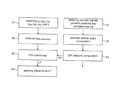
The left part of figure 8 is a flowchart of a particular embodiment of the
method
according to the invention, implemented by the bird D (see figures 5A and 5B).
In a step 81, the bird D obtains acoustic propagation times (e.g. tAD, tBD and
tco),
known inter-node distances (e.g. dAB, dec and dAc) and the underwater acoustic
sound
velocity (k, which is either measured or estimated).
CA 02821747 2013-07-23
16
In a step 82, the bird D computes the distance dHB (local measurement of a
parameter linked to the feather angle a).
In a step 83, the bird D computes a lateral force LF to be applied, as a
function of
the computed distance dHB, e.g. with a local PID control loop which enslaves
the computed
distance dHB on a setpoint SP.
In a step 84, the bird D applies (with the motorized pivoting wings 12) the
computed lateral force LF.
First implementation
In a first implementation, the setpoint SP is a predetermined value (for
example
corresponding to a feather angle of 00, 50 or 10 ). This predetermined value
can be stored
in a memory of the bird D. It can also be sent to the bird D by a master
streamer controller
(comprised e.g. in the navigation system or any other control system, on board
of the
seismic vessel).
In order to locally compute the lateral force to apply, the bird D only takes
in
account the locally measured distance dHB and the pre-established set point.
This allows to keep an optimised feather angle of the master streamer 51, even
if
none connection to the master streamer controller is available (streamer
disconnection, a
master streamer controller powered off, etc).
As the slave streamers (52 in figures 5A and 5B) keep a separation with the
attached master streamer, then the feather angle is reduced on the whole
streamer network,
even if none connection is available between the master streamer 51 and the
master
streamer controller.
Second implementation
In practice, the streamer feather angle a caused by the lateral sea current
can
regularly be much higher than 10 , whereas the birds can typically correct a
feather angle of
approximately 3 .
Moreover, the distance dHB (i.e. the inline offset in the particular
embodiment of
figures 5A and 5B) measured by each bird along a streamer may be different due
to the
streamer distortion.
Each function, streamer angle reduction and distortion reduction, has a cost
on the
lateral force which can be expressed in lateral force dynamic. Then if, on a
master streamer
CA 02821747 2013-07-23
17
the whole dynamic of lateral force is used for streamer angle reduction, then
the streamer
still may be distorted.
Moreover, in that case the whole dynamic of lateral force of the slave
streamer may
also be used, as the slave streamer try to keep a fixed streamer separation
(cross-line
distance) with respect to the attached master streamer. It could result to a
loss of streamer
separation, which can be worth than a presence of a feather angle.
Finally, it may be beneficial for binning coverage or 4D repeatability to
remove
streamer distortion instead of trying to reduce to 7 the streamer feather
angle without
reducing the streamer distortion.
So, in a second implementation, the method according to the invention is used
to
keep a same global feather angle ag along a streamer, reducing the streamer
distortion, and
keeping a free dynamic of lateral force on the birds of slave streamers.
As illustrated in figure 6, the global feather angle ag (also referred to as
the
"streamer feather angle"), is the mean feather angle over a streamer
(different of the feather
angle measured by a bird, also referred to above as "the local measurement of
the feather
angle"). It can be computed in real time by the navigation system (step 92,
part right of
figure 8), e.g. with a least square algorithm which uses, as inputs, acoustic
signals, geodetic
positions and compass bearing (these inputs are obtained in step 91, part
right of figure 8).
The streamer feather angle ag can be used to determine the set point SP for
all the
birds along the master streamer 51 (step 93, part right of figure 8). Then the
distortion along
the streamers may be reduced without modifying the streamer feather angle.
In that case, and in the particular context of figures 5A and 5B, the set
point SP is
defined by:
SP =CROSSLINE DISTANCE SETPOINT.tan(a
where CROSSLINE DISTANCE SETPOINT is the streamer separation (crossline
distance) setpoint, and ag is the effective streamer feather angle.
Now referring to figure 7, we present the simplified structure of a navigation
control device 70 (bird D in the above discussion) according to a particular
embodiment of
the invention.
The navigation control device 70 comprises a read-only memory (ROM) 73, a
random access memory (RAM) 71 and a processor 72. The read-only memory 73 (non
transitory computer-readable carrier medium) stores executable program code
instructions,
CA 02821747 2013-07-23
18
which are executed by the processor 72 in order to enable implementation of
the technique
of the invention (e.g. the steps 81 to 84 of figure 8).
Upon initialization, the aforementioned program code instructions are
transferred
from the read-only memory 73 to the random access memory 71 so as to be
executed by the
processor 72. The random access memory 71 likewise includes registers for
storing the
variables and parameters required for this execution. The processor 72
receives the
following information:
= acoustic propagation times (e.g. tAD, tBD and tco);
= known inter-node distances (e.g. dAB, dBc and dAc);
= a measured value of the underwater acoustic sound velocity (k). In an
alternative
embodiment, this value is estimated by the processor 72 (see Patent
Application
EP 11305835.8);
= the setpoint SP.
According to the program code instructions, the processor 72 delivers the
computed
lateral force LF (see steps 82 and 83 in figure 8), to be applied by the
motorized pivoting
wings 12.
All the steps of the above estimation method can be implemented equally well:
= by the execution of a set of program code instructions executed by a
reprogrammable computing machine such as a PC type apparatus, a DSP (digital
signal processor) or a microcontroller. This program code instructions can be
stored in a non-transitory computer-readable carrier medium that is detachable
(for
example a floppy disk, a CD-ROM or a DVD-ROM) or non-detachable; or
= by a dedicated machine or component, such as an FPGA (Field Programmable
Gate Array), an ASIC (Application-Specific Integrated Circuit) or any
dedicated
hardware component.