Note: Descriptions are shown in the official language in which they were submitted.
CA 02822180 2013-06-18
- 1 -
Measuring appliance comprising a dynamic sighting
functionality and associated method
The invention relates to a construction measuring
appliance for measuring and/or marking spatial points
of surfaces of a construction - in particular interiors
of buildings - and to an associated method for the
manually controlled alignment of a sighting unit of a
measuring appliance on the basis of marking display
points on a display, and to an associated computer
program product.
The prior art discloses simple construction measuring
appliances comprising a sighting device, with the aid
of which a spatial point, e.g. a corner point, is
sighted manually and the sighting direction is then
changed manually to a next spatial point to be
measured, e.g. a further corner point.
DE 196 48 626 for example discloses a method and an
apparatus for area measurement with a laser distance
measuring device having a laser transmitter and a laser
receiver. The laser distance measuring device is
mounted on a stand. The apparatus furthermore comprises
a tilting and rotating device for alignment and
direction measurement, a telescopic sight and also an
electronic evaluation unit for angle data acquisition,
distance data acquisition and data transfer to a
computer. For measuring a space, the appliance is
positioned at a central location in the space, from
which all spatial and/or area corner points to be
detected can be sighted and impinged upon by the laser
beam. In accordance with the disclosure of
DE 196 48 626, the spatial points to be measured are in
this case each sighted individually, if appropriate -
in the case of relatively large distance - with the
observation being supported by means of a telescopic
sight. An automated sequential measurement of a
CA 02822180 2013-06-18
- 2 -
plurality of spatial points, comparable to a scan, for
example, is not disclosed in DE 196 48 626.
A similar apparatus and associated measurement method
are disclosed in DE 44 43 413, the supplementary
published patent application DE 195 45 589 and
WO 96/18083, which claims the priority of DE 44 43 413.
They describe a method and an apparatus for measuring
and marking on distant lines, areas or in at least
partly closed spaces. One or a plurality of relevant
spatial points are measured according to in each case
two solid angles and the distance relative to a
reference location by means of a laser distance
measuring appliance mounted in a cardan-type fashion.
The laser distance measuring appliance is pivotable
about two mutually perpendicular axes equipped with
goniometers. In accordance with one embodiment
described in said documents, spatial points to be
measured are headed for manually and marking points are
calculated from the measurement data, on the basis of a
predefined relative relation between measurement and
marking, said marking points then being moved to
automatically by the measuring and marking apparatus.
However, this document also does not disclose an
automated sequential measurement of a plurality of
spatial points, comparable to a scan, for example.
EP 1 733 185 discloses an apparatus and a method
whereby specifically edges on a polygonal, otherwise
planar surface are intended to be measured precisely.
However, an automated sequential measurement of a
plurality of spatial points is not disclosed.
Known construction measuring appliances typically
comprise a base, an upper part mounted on the base in a
manner rotatable about a rotation axis, and a sighting
unit, which is mounted in a manner pivotable about a
CA 02822180 2013-06-18
- 3 -
pivoting axis, having a laser source designed to emit a
laser beam, and an imaging detector, for example
equipped with an alignment indicating functionality for
indicating an alignment of the sighting unit with a
spatial point as sighting point, and also a distance
determining detector for providing a distance measuring
functionality. The alignment indicating functionality
can be, for example, a reticle in the view finder of a
camera as imaging detector.
Modern, automated construction measuring appliances
furthermore comprise rotary drives, which make the
upper part and/or the sighting unit drivable in a
motorized manner, goniometers and, if appropriate
inclination sensors for determining the spatial
alignment of the sighting unit, and also an evaluation
and control unit, which is connected to the laser
source, the distance determining detector and also the
goniometers and, if appropriate, inclination sensors.
In this case, the evaluation and control unit is
equipped for example with a display having input means
for inputting control commands of a user on the display
and for representing an image of the imaging detector
or camera on the display, wherein the alignment of the
sighting unit can be indicated by means of the
alignment indicating functionality on the display e.g.
by means of overlaying. Functionalities are known in
which the input means on the display are designed as
four large areal arrows, the marking and touching of
which enable a user to change the alignment of the
sighting unit in a horizontal or vertical direction.
However, changing the alignment in an arbitrary
direction, not exclusively in a horizontal or vertical
direction, on the basis of such a functionality, can be
time-consuming and difficult to handle and not very
intuitive to operate.
CA 02822180 2013-06-18
- 4 -
The problem addressed by the invention is that of
providing a measuring appliance and an associated
method for measuring and/or marking spatial points on
surfaces of a construction with an improved
functionality for changing the alignment of the
sighting unit which offers a user increased operating
convenience and, in particular, on the basis of which
the user can move more rapidly to the desired target
point in the space - at least roughly.
The invention relates to a measuring appliance (in
particular construction measuring appliance) for
measuring and/or marking spatial points on surfaces of
a construction, in particular interiors of buildings.
The appliance comprises a base and a sighting unit,
which is rotatable and pivotable relative to the base
and provides distance measuring functionality, having a
laser source designed to emit a laser beam in the
direction of an aiming axis, and a laser light detector
and also having an integrated digital camera aligned
in the direction of the aiming axis.
In particular, an upper part mounted on the base in a
manner rotatable about a rotation axis within an
angular range of an azimuthal or horizontal angle is
present and the sighting unit is arranged in a manner
mounted on the upper part in a manner pivotable about a
pivoting axis within an angular region of an elevation
or vertical angle.
The measuring appliance according to the invention
furthermore comprises an evaluation and control unit, a
display for representing an image of the camera, and
also input means for marking display points on the
display (such that e.g. control commands can be input
by a user). In this case, the input means are designed
in particular in such a way that - with a specific
resolution - points on the entire display (that is to
CA 02822180 2013-06-18
- 5 -
say on the entire display area) can be marked (e.g.
analogously to a computer mouse, a touchscreen, a
trackball, or the like). As known to the person skilled
in the art, in this case although the resolution of
markable display points can specifically correspond to
the screen resolution (screen pixel) per se, it is
equally possible for the resolution of markable display
points also to be lower than the resolution of the
pixel actually representable on the screen.
In this case, in the operating state, the spatial point
respectively currently sighted by means of the aiming
axis can be imaged on the display in the image (in a
target image point), in particular in a manner
indicated on the basis of a reticle.
The appliance comprises a first and second rotary
drive, which make the upper part and the sighting unit
respectively drivable and alignable in an azimuth angle
and an elevation angle. A spatial alignment of the
sighting unit relative to the base is detectable by
means of two goniometers for determining the horizontal
and vertical alignment, i.e. the azimuth angle and the
elevation angle. The evaluation and control unit is
connected to the laser source, the laser light detector
and also the goniometers in order to assign a detected
distance to a corresponding alignment (that is to say
azimuth and elevation angles detected in this case) and
thus to determine coordinates for spatial points.
Moreover, the evaluation and control unit is also
connected to the camera.
In addition, the appliance - in particular in a manner
integrated into the base of the appliance - can
optionally be equipped with inclination sensor means,
the measurement data of which are then likewise
communicated to the evaluation and control unit.
Therefore, it is additionally possible to determine the
CA 02822180 2013-06-18
- 6 -
current alignment of the appliance (that is to say an
inclination of the base) with respect to the Earth's
gravitational field vector and to use it to compensate
for the appliance not being installed exactly
horizontally. As known to the person skilled in the
art, in this case the inclination sensor means can be
designed to determine the inclination relative to the
gravitational field (or relative to a horizontal plane
aligned perpendicularly to the gravitational field) in
two directions (that is to say about two axes). By way
of example, for this purpose it is possible to use two
one-axis inclination sensors or one two-axis
inclination sensor (such as optoelectronic spirit level
sensors, an optoelectronic oil reservoir or an
optoelectronic box level). An example of such an oil-
reservoir-like inclination sensor which can be used to
determine the inclination at least about two axes is
described in detail in the European patent application
having the application number EP 10173726Ø
According to the invention, the construction measuring
appliance has a functionality (dynamic sighting
functionality) in the context of which dynamically in a
manner dependent on
= a current direction and
= a current distance
from a defined central anchor display point to a
currently marked display point, the alignment of the
sighting unit is changed by the first and/or second
rotary drive, wherein
= the
respective current direction predefines an
alignment change direction and
CA 02822180 2013-06-18
- 7 -
= the respective current distance predefines an
alignment change speed
for changing the alignment of the sighting unit.
In particular, the anchor display point can be defined
as that display point which represents the position of
the aiming axis in the image and thus a target image
point, in particular wherein the latter is indicated on
the display by a reticle that can be represented in a
manner superimposed on the image. Alternatively,
however, in the context of the functionality, it can
also be provided that the user himself/herself can
define an arbitrary display point as the anchor display
point.
In this case, the functionality can be configured in
such a way that it can be activated by marking the
reticle or the display point representing the target
image point.
Preferably, the display is embodied as a touch-
sensitive touchscreen, on which display points on the
entire area of the display can be marked by touch, and
the input means are thereby provided.
According to the invention, the alignment of the
sighting unit is changed in horizontal and vertical
directions in accordance with the direction from the
defined central anchor display point to the respective
currently marked image point. It is preferably the case
here that the alignment is changed with a maximum speed
in the case of a maximum distance between the marked
image point and the anchor point and the speed of the
alignment change is equal to zero, that is to say that
no change in direction takes place, if the first and
second marked image points coincide, that is to say are
identical.
CA 02822180 2013-06-18
- 8 -
In accordance with one possible embodiment of the
construction measuring appliance according to the
invention, the display is subdivided into virtual
sectors by means of a virtual line grid, said sectors
being formed by concentric circular lines around the
anchor display point (such as e.g. the center point of
the reticle) and radial lines which proceed from the
anchor display point and intersect said circular lines.
In this case, the sectors correspond to digitized
differences for a change in the alignment of the
sighting unit from the first sighted spatial point to
other spatial points in horizontal and vertical
directions, and the alignment of the sighting unit is
changed for as long as the other image point in a
sector is continuously marked.
In accordance with this embodiment of the invention,
the concentric circular lines around the anchor display
point correspond to different distances with respect to
the currently marked image point, whereby speed levels
for the change in direction of the sighting unit are
defined, wherein outer circular lines correspond to
maximum speed levels, such that the change in direction
upon the marking of outer image points, after the
activation of the dynamic sighting functionality, takes
place with a defined maximum speed, as long as said
other image point is marked.
Typically, the distance measuring functionality
comprises an electronic distance measuring device.
Optionally, the virtual line grid can be representable
in a manner superimposed on a current camera image on
the display in a manner visible to a user.
Further subject matter of the invention is a method for
the manually controlled alignment of a sighting unit of
CA 02822180 2013-06-18
- 9 -
a measuring appliance on the basis of marking display
points on a display, wherein the measuring appliance -
as described above - comprises:
= abase,
= the sighting unit, which is rotatable and
pivotable relative to the base and provides distance
measuring functionality, having a laser source designed
to emit a laser beam in the direction of an aiming
axis, and a laser light detector and also having an
integrated digital camera aligned in the direction of
the aiming axis,
= an evaluation and control unit,
= the display for representing an image of the
camera, and
= input means for marking the display points,
wherein
= a first and a second rotary drive make the
sighting unit drivable and alignable,
= a spatial alignment of the sighting unit relative
to the base is detectable by means of two goniometers,
and
= the evaluation and control unit is connected to
the laser source, the laser light detector and also the
goniometers in order to assign a detected distance to a
corresponding alignment and thus to determine
coordinates for spatial points, and is also connected
to the camera.
CA 02822180 2013-06-18
- 10 -
According to the invention, in the context of the
method, constantly
= a current direction and
= a current distance
from a defined central anchor display point to a
currently marked display point are determined. The
alignment of the sighting unit is then changed
dynamically in a manner dependent on the respective
current direction and the respective current distance
by the first and/or second rotary drive, wherein
= the
respective current direction predefines an
alignment change direction and
= the respective current distance predefines an
alignment change speed
for changing the alignment of the sighting unit.
All of the developments described initially with regard
to the measurement appliance according to the invention
are analogously also applicable to the method according
to the invention.
Thus, once again e.g. the anchor display point can be
defined as that display point which represents the
position of the aiming axis in the image and thus a
target image point, in particular wherein the latter is
indicated on the display by a reticle that can be
represented in a manner superimposed on the image.
Likewise, again the alignment change direction for
changing the alignment of the sighting unit can be
chosen analogously to the respective determined current
CA 02822180 2013-06-18
- 11 -
direction from the anchor display point to the
currently marked display point, wherein
= the alignment change direction contains an
upwardly directed component - that is to say the
sighting unit is pivoted upward about a horizontal
pivoting axis - if the current direction from the
anchor display point to the currently marked display
point contains an upwardly pointing component - that is
to say if the currently marked display point on the
display is situated above the anchor display point,
= the alignment change direction contains a
downwardly directed component - that is to say the
sighting unit is pivoted downward about the horizontal
pivoting axis - if the current direction from the
anchor display point to the currently marked display
point contains a downwardly pointing component - that
is to say if the currently marked display point on the
display is situated below the anchor display point,
= the alignment change direction contains a leftward
directed component - that is to say the sighting unit
is rotated leftward about a vertical rotation axis - if
the current direction from the anchor display point to
the currently marked display point contains a leftward
pointing component - that is to say if the currently
marked display point on the display is situated to the
left of the anchor display point, and
= the alignment change direction contains a
rightward directed component - that is to say the
sighting unit is rotated rightward about a vertical
rotation axis - if the current direction from the
anchor display point to the currently marked display
point contains a rightward pointing component - that is
to say if the currently marked display point on the
CA 02822180 2013-06-18
- 12 -
display is situated to the right of the anchor display
point.
Furthermore, the dependence of the alignment change
speed on the respective current distance can be defined
in such a way that the movement (that is to say
rotation and/or pivoting) of the sighting unit is
effected with maximum available speed if the current
distance from the currently marked display point to the
anchor display point is maximal, and when the currently
marked display point coincides with the anchor display
point, the alignment change speed is equal to zero,
that is to say that a pause is then made in the current
alignment of the sighting unit.
Further subject matter of the invention is a computer
program product comprising program code, stored on a
machine-readable carrier, for carrying out the method
according to the invention for the manually controlled
alignment of a sighting unit of a measuring appliance
on the basis of marking display points on a display
according to one of the embodiments mentioned above, in
particular if the program is executed on an electronic
data processing unit embodied as an evaluation and
control unit of the above-described measuring appliance
according to the invention.
The present invention allows an operator to change the
alignment of the sighting unit in a simple manner. It
is not necessary to sequentially input commands for an
alignment change in horizontal and vertical directions,
rather the sighting unit can, according to the
invention, be moved in any desired, e.g. diagonal,
direction by means of simple marking on the display (in
addition, the chosen direction and speed for the
movement can be continuously adapted and changed
dynamically by displacement of the marking (i.e.
marking of a different display point)).
CA 02822180 2013-06-18
- 13 -
The construction measuring appliance according to the
invention and the method according to the invention for
measuring and/or marking spatial points in a
construction are described in greater detail purely by
way of example below on the basis of concrete exemplary
embodiments illustrated schematically in the drawings,
and further advantages of the invention are also
discussed. Specifically in the figures:
figure 1 illustrates a first illustration for a
possible embodiment of a
construction
measuring appliance according to the =
invention;
figure 2 illustrates a second illustration for a
possible embodiment of a construction
measuring appliance according to the
invention;
figure 3 shows the functioning of the dynamic sighting
functionality of the construction measuring
appliance according to the invention and of
the associated method according to the
invention on the basis of an example.
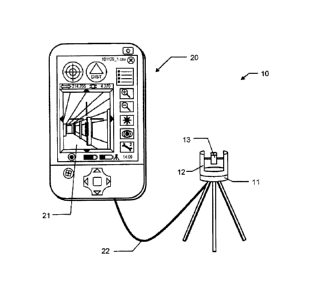
Figure 1 shows one possible embodiment of a
construction measuring appliance 10 according to the
invention. The system 10 comprises a supervisory unit
20 having an integrated evaluation and control unit for
processing the data and having a touch-sensitive touch
display 21 for displaying data/camera images and for
marking display points (and inputting commands). The
supervisory unit 20 (as user-appliance interface) and a
laser light detector or sensor communicate with one
another. The supervisory unit 20 and the laser light
detector or sensor can be physically separate and be
connected to one another by means of wireless or cable-
CA 02822180 2013-06-18
- 14 -
based communication connections 22 or can be provided
as one unit. In order to align the laser beam 14 with
spatial points to be measured or to be protected, at
least the laser beam 14 can serve as a measurement beam
itself. In order to support an operator for sighting a
spatial point, the construction measuring appliance 10
can additionally be equipped with a direct optical
sighting aid, e.g. a telescope.
Figure 2 illustrates a measuring appliance 10 according
to the invention for measuring and/or for marking
spatial points of surfaces of a construction, in
particular of interiors of buildings.
The construction measuring appliance 10 comprises a
base 11, which is supported for example on a tripod
stand, with an upper part 12 mounted thereon in a
rotatable manner. A sighting unit 13 mounted on the
upper part 12 in a pivotable manner is equipped with a
laser source designed to emit a laser beam 14, and a
laser light detector as distance determining detector,
and thus provides a distance measuring functionality.
The sighting unit 13 furthermore comprises an
integrated digital camera.
Consequently, the sighting unit 13 is therefore
rotatable and pivotable relative to the base 11 (that
is to say in particular rotatable about a vertical axis
and pivotable or inclinable about a horizontal pivoting
axis).
The construction measuring appliance 10 additionally
comprises an evaluation and control unit (not
illustrated), wherein - likewise not illustrated - a
first and a second rotary drive make the upper part 12
and the sighting unit 13 respectively drivable and
alignable in an azimuth angle and an elevation angle.
The spatial alignment of the sighting unit 13 relative
CA 02822180 2013-06-18
- 15 -
to the base 11 is detectable by means of two
goniometers. In addition, provision can be made of
inclination sensors for determining the installation
alignment or horizontality of the base 11 relative to
the Earth's gravitational field vector. The evaluation
and control unit is connected to the laser source, the
laser light detector and the goniometers - and also, if
appropriate, the inclination sensors - in order to
assign a detected distance and detected azimuth and
elevation angles to a corresponding alignment of the
sighting unit 13 and thus to determine coordinates for
spatial points. Moreover, the evaluation and control
unit is connected to the camera.
In this case, in the operating state, the spatial point
respectively currently sighted by means of the aiming
axis 13 can be imaged on the display in the image (in a
target image point), in particular in a manner
indicated on the basis of a reticle that can be
represented.
The camera image, into which therefore the reticle can
be inserted at that location in the image which
corresponds to the aiming axis, therefore serves in
particular for sighting the desired target points in
the space and can be displayed e.g. on the display of a
remote control unit, which can be handheld, for the
construction measuring appliance (in particular as a
live video stream).
As known to the person skilled in the art, the
evaluation and control unit and also the display and
the input means can either be arranged directly on the
base of the appliance and/or be integrated into a
remote control unit, which can be handheld. The
measuring appliance can therefore have (either
exclusively or in addition to a user interface with
display and input means which can be arranged directly
CA 02822180 2013-06-18
- 16 -
on the base) a remote control unit with input means and
display.
According to the invention, the measuring appliance 10
now has a dynamic sighting functionality, in the
context of which the user can manually give control
commands for changing the alignment of the sighting
device relative to the base. The dynamic sighting
functionality can be configured in such a way that it
can be activated by marking the target image point or
the reticle on the display. After the dynamic sighting
functionality has been activated, a user can mark a
display point 4 on the display. As a result, a dynamic
change in the alignment of the sighting unit 13 is
instigated by virtue of the azimuthal and/or
elevational alignment being changed in a motor-driven
manner - in accordance with the currently determined
direction and the currently determined distance from
the defined central anchor display point to the
respective currently marked display point.
Upon cancellation of the marking, for example upon
cancellation of the touching of the display point 4 on
a display embodied as a touchscreen (see figure 3), the
movement of the sighting unit 13 is terminated.
However, a user can - if the functionality still
remains activated - at any time mark or touch a
different display point in order to instigate a change
in alignment, which then in turn corresponds to the
current direction and the current distance from the
central anchor display point to this marked different
display point.
In this case, the alignment change direction for
changing the alignment of the sighting unit is
dynamically dependent on the respective currently
determined direction from the center point of the
reticle (which can be defined e.g. as the central
CA 02822180 2013-06-18
- 17 -
anchor display point) to the currently marked display
point 4. That is to say that in this case the alignment
change direction is dynamically set analogously to the
respective current direction from the anchor display
point to the currently marked display point.
Consequently, when the alignment of the sighting unit
is changed analogously to the respective currently
determined direction (from the center point of the
reticle to the currently marked display point 4), it is
evident that
= the alignment change direction is chosen/set in a
manner containing an upwardly directed component - that
is to say the sighting unit is pivoted upward about a
horizontal pivoting axis - if the current direction
from the anchor display point to the currently marked
display point contains an upwardly pointing component -
that is to say if the currently marked display point
on the display is situated above the anchor display
point,
= the alignment change direction is chosen/set in a
manner containing a downwardly directed component -
that is to say the sighting unit is pivoted downward
about a horizontal pivoting axis - if the current
direction from the anchor display point to the
currently marked display point contains a downwardly
pointing component - that is to say if the currently
marked display point on the display is situated below
the anchor display point,
= the alignment change direction is chosen/set in a
manner containing a leftward directed component - that
is to say the sighting unit is rotated leftward about a
vertical rotation axis - if the current direction from
the anchor display point to the currently marked
display point contains a leftward pointing component -
that is to say if the currently marked display point
CA 02822180 2015-05-01
- 18 -
on the display is situated to the left of the anchor display
point,
= the alignment change= direction is chosen/set in a manner
containing a rightward directed component - that is to say the
sighting unit is rotated rightward about the vertical rotation
axis - if the current direction from the anchor display point to
the currently marked display point contains a rightward pointing
component - that is to say if the currently marked display point
on the display is situated to the right of the anchor display
point.
In this case, the alignment change speed for changing the
alignment of the sighting unit is set dynamically depending on
the respective currently determined distance from the currently
marked display point 4 to the center point of the reticle (which
can be defined e.g. as the central anchor display point), in
particular wherein, as the distance between the currently marked
display point and the anchor display point increases, the
sighting unit is in each case moved with increasing alignment
change speeds.
In this case, the speed of the change of alignment can be
predefined as maximal in the case of maximal distance between
the marked display point 4 and the target image point 1 or
center point of the reticle (as anchor display point) - i.e.
when marking outer display points on the display - and can be
chosen to be equal to zero if the currently marked display point
4 coincides with the target image point 1 or center point of the
reticle as anchor display point. That is to say that, in the
latter case, no change in the alignment of the sighting unit 13
(that is to say no movement of the sighting unit) is effected.
CA 02822180 2013-06-18
- 19 -
In accordance with the embodiment of the invention as
illustrated in figure 3, the display is subdivided into
a virtual line grid 3, corresponding to digitized
distances and directions from the target image point 1
or the center point of the reticle to groups of display
points. In the embodiment in accordance with figure 3,
the virtual line grid 3 is formed from concentric
circular lines 5 around the center point of the reticle
and radial lines 6 which proceed from the center point
of the reticle and intersect said circular lines, such
that the display is thereby divided into sectors 7 -
each containing a group of a plurality of display
points. In this case, the sectors 7 in each case
correspond to concrete values for the alignment change
direction and alignment change speed when changing the
alignment of the sighting unit 13 (that is to say that
the display points lying within a sector are in each
case assigned the same concrete value for the alignment
change direction and alignment change speed). The
alignment of the sighting unit 13 is changed in a
vertical and, in particular simultaneously, horizontal
direction, in the direction of the different marked
image point 4 - located in a sector corresponding to a
different spatial point to be sighted, for as long as
said different image point is continuously marked. Upon
cancellation of the marking, for example upon
cancellation of the touching of the image point 4 on a
display embodied as a touchscreen, the movement of the
sighting unit 13 is terminated. However, a user can at
any time mark or touch a different display point in a
different sector 7 in order to instigate a change in
the alignment of the sighting unit 13 in accordance
with the direction and speed assigned to this sector
for changing the alignment.
Sectors situated further outward (which have a greater
distance from the anchor display point) in this case
CA 02822180 2013-06-18
- 20 -
correspond to higher alignment change speeds and
sectors situated further inward (which have a smaller
distance from the anchor display point) in this case
correspond to lower alignment change speeds. As the
distance between the respective sectors and the anchor
display point (that is to say center point of the
reticle) increases, therefore, the alignment change
speed respectively assigned to the sectors also
increases.
In this case, the sectors defined by the outermost
circular line can also be assigned the highest movement
speed (100%) and a marking of the anchor display point
(that is to say of the center point of the reticle) can
mean a movement speed of 0%.
Each sector 7 furthermore corresponds to a specific -
that is to say assigned thereto - alignment change
direction of the sighting unit 13 (azimuthal and
elevational). When an image point e.g. to the right of
the center point of the reticle is marked or touched,
the sighting device 13 is moved toward the right for
changing the alignment in a horizontal direction until
the different image point mentioned above is no longer
marked or touched (for example because now another
different display point is marked - and then the
sighting unit is moved further or changed further with
the direction and speed assigned to said display point
- or no point is marked anymore - and the movement of
the sighting unit is then stopped). The situation
illustrated in figure 3 (with the point illustrated
here as currently marked display point 4) corresponds,
for instance, to a change in the alignment of the
sighting unit 13 with an alignment change direction
upward obliquely toward the right (that is to say a
direction change component pointing upward and a
direction change component pointing rightward, wherein
the component pointing upward is chosen to be somewhat
CA 02822180 2013-06-18
- 21 -
greater than the component pointing rightward) and also
with an average movement speed. In particular, for this
purpose the rotary drives can be driven in such a way
that the sighting unit pivots upward relative to the
base at 60% of the maximum pivoting speed that can be
provided, and rotates rightward about the vertical axis
at 40% of the maximum rotational speed that can be
provided.
In particular, in this case the line grid 3 is
established in such a way that a multiplicity of
sectors 7 are defined thereby, in particular at least
approximately 30 sectors, specifically at least
approximately 50 sectors.
It goes without saying that these illustrated figures
merely illustrate possible exemplary embodiments
schematically. The various approaches can likewise be
combined with one another and also with methods and
appliances from the prior art.