Note: Descriptions are shown in the official language in which they were submitted.
CA 02823273 2013-06-27
MEASURING APPLIANCE COMPRISING AN AUTOMATIC
REPRESENTATION-CHANGING FUNCTIONALITY
The invention relates to a measuring appliance for
measuring and/or marking spatial points in the context of
construction and/or development - in particular interior
finishing - of buildings and to an associated method and an
associated computer program product.
A further aspect according to the invention relates to
a system comprising a construction measuring appliance and
at least three reference point marks which can be fitted in
spaces and to a construction measuring appliance suitable
for precisely such a system.
The prior art discloses construction measuring
appliances comprising a sighting device, with the aid of
which a spatial point, e.g. a corner point of a space, is
sighted manually and the sighting direction is then changed
manually to a next spatial point to be measured, e.g. a
further corner point.
DE 196 48 626 for example discloses a method and an
apparatus for area measurement with a laser distance
measuring device having a laser transmitter and a laser
receiver. The laser distance measuring device is mounted on
a stand. The apparatus furthermore comprises a tilting and
rotating device for alignment and direction measurement, a
telescopic sight and also an electronic evaluation unit for
angle data acquisition, distance data acquisition and data
transfer to a computer. For measuring a space, the appliance
is positioned at a central location in the space, from which
all spatial and/or area corner points to be detected can be
sighted and impinged upon by the laser beam. In accordance
with the disclosure of DE 196 48 626, the spatial points to
be measured are in this case each sighted individually, if
appropriate -in the case of relatively large distance - with
1
CA 02823273 2013-06-27
the observation being supported by means of a telescopic
sight. An automated sequential measurement of a plurality of
spatial points, comparable to a scan, for example, or
functionalities that can be initiated for user-defined
changes between three- and two-dimensional representations
of measured spatial regions are not disclosed in
DE 196 48 626.
A similar apparatus and associated measurement method
are disclosed in DE 44 43 413, the supplementary published
patent application DE 195 45 589 and WO 96/18083, which
claims the priority of DE 44 43 413. They describe a method
and an apparatus for measuring and marking on distant lines,
areas or in at least partly closed spaces. One or a
plurality of relevant spatial points are measured according
to in each case two solid angles and the distance relative
to a reference location by means of a laser distance
measuring appliance mounted in a cardan-type fashion. The
laser distance measuring appliance is pivotable about two
mutually perpendicular axes equipped with goniometers. In
accordance with one embodiment described in said documents,
spatial points to be measured are headed for manually and
marking points are calculated from the measurement data, on
the basis of a predefined relative relation between
measurement and marking, said marking points then being
moved to automatically by the measuring and marking
apparatus.
However, this document also does not disclose an
automated sequential measurement of a plurality of spatial
points, comparable to a scan, for example, or
functionalities that can be initiated for user-defined
changes between three- and two-dimensional representations
of measured spatial regions.
EP 1 733 185 discloses an apparatus and a method
whereby specifically edges on a polygonal, otherwise planar
2
CA 02823273 2013-06-27
surface are intended to be measured precisely. However, an
automated sequential measurement of a plurality of spatial
points or functionalities that can be initiated for
user-defined changes between three- and two-dimensional
representations of measured spatial regions are not
disclosed.
The problem addressed by the invention is that of
providing a measuring appliance and an associated method for
measuring and marking spatial points in a construction, in
particular an interior of a building, whereby a simple and
rapid change from an initial representation of stored or
already measured points of a space to an elevation
representation of the space is made possible, which
elevation representation is displayed on the display and can
be read and interpreted in a simple manner.
This problem is solved by the presently described
embodiments. All embodiments of the invention which are
illustrated or disclosed in some other way in this document
can be combined with one another, unless expressly stated
otherwise.
The invention relates to a measuring appliance for
measuring and in particular marking spatial points of a
construction - in particular interiors of buildings. The
measuring appliance comprises a base, a sighting unit, which
is rotatable and pivotable relative to the base and provides
distance measuring functionality, having a laser source
designed to emit a laser beam in the direction of an aiming
axis, and a laser light detector, an evaluation and control
unit and a display. In this case, a spatial alignment of the
sighting unit relative to the base is detectable by means of
two goniometers. Moreover, the is connected to the laser
source, the laser light detector and also the goniometers in
order to assign a detected distance to a corresponding
alignment and thus to determine coordinates for spatial
3
CA 02823273 2013-06-27
points. Furthermore, input or measured spatial points, which
form a spatial point set, can be stored, for example in
storage means provided by the evaluation and control unit.
Furthermore, a plan view representation or spatial
representation of at least some spatial points from the
spatial point set can be displayed on the display, wherein
said spatial points are at least partly connected by lines.
According to the invention, then, the measuring
appliance has a representation-changing functionality, in
the context of which, depending on a line selected - from
the lines displayed in the plan view representation or the
spatial representation - by the user, in a
manner
automatically controlled by the evaluation and control unit,
= a virtual area is defined by the selected line and a
direction predefined as vertical,
= a subset of spatial points which lie within a buffer
zone surrounding the virtual area in a defined manner
is selected from the spatial point set, and
= an elevation representation of exclusively such spatial
points which belong to the subset is displayed on the
display.
In particular, in the context of the elevation
representation exactly all those spatial points which belong
to the subset are represented, wherein they are at least
partly connected by lines in the elevation representation as
well.
In this case, the buffer zone can extend in front of
and behind the virtual area as far as a defined maximum
distance from the virtual area, in particular wherein a
value for the maximum distance is fixedly predefined or can
4
CA 02823273 2013-06-27
be predefined by the user in a range of between 0 and
100 cm, specifically in a range between 10 and 50 cm.
In accordance with one advantageous aspect, the
representation-changing functionality according to the
invention can be started automatically as a result of the
one line being selected by the user - in particular by
double clicking with the aid of input means - whereupon
automatically - in particular directly in response to the
selection by the user - the virtual area is defined, the
subset is selected and a change is made to the elevation
representation and this is displayed on the display.
In this case, spatial representation is defined as a
three-dimensional perspective representation of spatial
points.
The plan view representation is defined as a two-
dimensional representation of spatial points - projected
onto a plane assumed to be aligned horizontally - and the
elevation representation is defined as a two-dimensional
representation of spatial points - projected onto a plane
assumed to be aligned vertically.
In particular, the measuring appliance can
comprise - in particular integrated into the
base - inclination sensor means designed for determining the
inclination relative to the Earth's gravitational field
vector about two axes and for communicating the measurement
data thereof to the evaluation and control unit, such that
the direction predefined as vertical can thereby be defined
or measured.
Alternatively, the direction predefined as vertical can
also be derived by a precalibration of a reference situated
with known outer alignment, in particular of two points of a
plumb rod or plumb bob suspended in oscillating fashion, or
CA 02823273 2013-06-27
of a reference plane assumed to be aligned horizontally or
vertically. The outer vertical direction can then be derived
on the basis of the data obtained in the context of the
recalibration by means of the evaluation and control unit.
The change from plan view representation to elevation
representation is entirely customary in CAD systems, such as
are employed primarily for construction purposes. However, a
change of point sets to be displayed in the different modes
of representation has to be decided and assigned point by
point by the user, and cannot be performed by a simple
wholesale selection in the sense of a buffer zone defined
depending on a selected line, such as is employed according
to the invention. Consequently, this point-by-point
selection process is time-consuming and does not meet the
requirements made in respect of a system which is easy to
operate and which, for the purposes of dimension detection,
for example, must not only be easily understandable but also
be operable time-efficiently. In particular, what can be
achieved according to the invention is that, for a system
user, it is possible to avoid the need to individually
select a large number of individual points just in order to
ensure an improved clarity of a representation chosen for a
short time.
Preferably, the distances in the horizontal and/or
vertical direction from the line connecting the selected
spatial points for the definition of the buffer zone for
measured spatial points contained therein for representation
in the two-dimensional projection are between 0 cm and
50 cm, particularly preferably between 0 cm and 20 cm.
In accordance with one particular embodiment of the
invention, the buffer zone contains spatial points which are
measured from a space adjoining the first measured space and
the three-dimensional coordinates of which can be correlated
with the three-dimensional data of the measured spatial
6
CA 02823273 2013-06-27
points of the first measured space and can be represented in
the two-dimensional projection. This can be made possible,
for example, by measurement of spatial points at common
walls of mutually adjoining spaces and storage and
correlation of these data.
Further subject matter of the invention is a method for
changing the representation from a plan view representation
or spatial representation displayed on a display of a
measuring appliance to an elevation representation, wherein
the measuring appliance - as described above - comprises:
= a base,
= a sighting unit, which is rotatable and pivotable
relative to the base and provides distance measuring
functionality, having a laser source designed to
emit a laser beam in the direction of an aiming
axis, and a laser light detector, .
= an evaluation and control unit, and
= a display
wherein
= a spatial alignment of the sighting unit relative to
the base is detectable by means of two goniometers,
= the is connected to the laser source, the laser
light detector and also the goniometers in order to
assign a detected distance to a corresponding
alignment and thus to determine coordinates for
spatial points,
= input or measured spatial points, which form a
spatial point set, are stored and
7
CA 02823273 2013-06-27
= the plan view representation or spatial
representation of at least some spatial points from
the spatial point set is displayed, wherein said
spatial points are at least partly connected by
lines.
According to the invention, in the context of the
method, depending on a line selected - from the lines
displayed in the plan view representation or the spatial
representation - by the user, automatically
= a virtual area is defined by the selected line and a
direction predefined as vertical,
= a subset of spatial points which lie within a buffer
zone surrounding the virtual area in a defined manner
is selected from the spatial point set, and
= an elevation representation of exclusively such spatial
points which belong to the subset is displayed on the
display.
All of the developments described initially with regard
to the measuring appliance according to the invention are
analogously also applicable to the method according to the
invention.
Thus, once again the buffer zone can extend in front of
and behind the virtual area as far as a defined maximum
distance from the virtual area, in particular wherein a
value for the maximum distance is fixedly predefined or can
be predefined by the user in a range of between 0 and
100 cm, specifically in a range between 10 and 50 cm.
Furthermore, in the context of the elevation
representation exactly all those spatial points which belong
to the subset are represented, wherein said spatial points
can be at least partly connected by lines.
8
CA 02823273 2013-06-27
Specifically, an automatic progression of the method
can be initiated or started as a result of the one line
being selected by the user - in particular by double
clicking with the aid of input means - whereupon
automatically - in particular directly in response to the
selection by the user - the virtual area is defined, the
subset is selected and a change is made to the elevation
representation and this is displayed on the display.
Further subject matter of the invention is a computer
program product comprising program code, stored on a
machine-readable carrier, for carrying out the method
according to the invention for changing the representation
from a plan view representation or spatial representation
displayed on a display of a measuring appliance to an
elevation representation of spatial points from a
stored
spatial point set, according to one of the abovementioned
embodiments, in particular if the program is executed on an
electronic data processing unit embodied as an evaluation
and control unit of the above-described measuring appliance
according to the invention.
The measuring appliance according to the invention and
the associated method are described in greater detail purely
by way of example below on the basis of concrete exemplary
embodiments illustrated schematically in the drawings, and
further advantages of the invention are also discussed.
Specifically in the figures:
Figure 1
illustrates a first illustration for a possible
embodiment of a construction measuring appliance
according to the invention;
Figure 2
illustrates a second illustration for a possible
embodiment of a construction measuring appliance
according to the invention;
9
CA 02823273 2013-06-27
Figure 3 shows
a plan view representation of stored and
already measured points of the space, said
representation being displayed on the display of
the appliance;
Figure 4 shows an example of determining the buffer zone
around the vertical area defined by the selected
line;
Figure 5 shows
an elevation representation of the spatial
points lying exclusively within the buffer zone,
said elevation representation being displayed
according to the invention on the display of the
appliance;
Figure 6 shows a measuring system designed in accordance
with a further aspect of the invention in its
application; and
Figure 7 shows
exemplary embodiments of reference point
marks of the measuring system designed in
accordance with the further aspect of the
invention.
Figure 1 shows one possible
embodiment of a
construction measuring appliance 10 according to the
invention. The system 10 comprises a supervisory unit 20
having an integrated evaluation and control unit for
processing the data and having a touch-sensitive touch
display 21 for displaying data/camera images and for marking
display points (and inputting commands). The supervisory
unit 20 (as user-appliance interface) and a laser light
detector or sensor communicate with one another. The
supervisory unit 20 and the laser light detector or sensor
can be physically separate and be connected to one another
by means of wireless Or cable-based communication
connections 22 or can be provided as one unit. In order to
CA 02823273 2013-06-27
align the laser beam 14 with spatial points to be measured
or to be protected, at least the laser beam 14 can serve as
a measurement beam itself. In order to support an operator
for sighting a spatial point, the construction measuring
appliance 10 can additionally be equipped with a direct
optical sighting aid, e.g. a telescope.
The camera image, into which, in the context of a
sighting mode, a reticle can be inserted at any location in
the image which corresponds to the aiming axis, thus serves
in particular for sighting the desired target points in the
space and can be displayed e.g. on the display of a remote
control unit that can be handheld for the construction
measuring appliance (in particular as a live video stream).
As to known to the person skilled in the art, the
evaluation and control unit and also the display and the
input means can either be arranged directly on the base of
the appliance and/or be integrated into a remote control
unit that can be handheld. The measuring appliance can
therefore have, for example, a base part that integrates the
sensor-type components and - physically
separated
therefrom - a remote control unit, which, for its part,
provides the input means and the display and, in particular,
also the evaluation and control unit.
According to the invention, the construction measuring
appliance 10 has a representation-changing functionality
which proceeds at least semiautomatically, which is
illustrated, however, in
particular with reference to
figures 2 to 5.
Figure 2 shows a measuring appliance 10 according to
the invention for measuring and/or for marking spatial
points of surfaces of a construction, in particular of
interiors of buildings.
11
CA 02823273 2013-06-27
The construction measuring appliance 10 comprises a
base 11, which is supported for example on a tripod stand,
with an upper part 12 mounted thereon in a rotatable manner.
A sighting unit 13 mounted on the upper part 12 in a
pivotable manner is equipped with a laser source designed to
emit a laser beam 14, and a laser light detector as distance
determining detector, and thus provides a distance measuring
functionality. The sighting unit 13 can furthermore
optionally be equipped with an integrated digital camera.
Consequently, the sighting unit 13 is therefore
rotatable and pivotable relative to the base 11 (that is to
say in particular rotatable about a vertical axis and
pivotable or inclinable about a horizontal pivoting axis).
The construction measuring appliance 10 additionally
comprises an evaluation and control unit (not illustrated
for the sake of simplification), wherein - likewise not
illustrated - a first and a second rotary drive make the
upper part 12 and the sighting unit 13 respectively drivable
and alignable in an azimuth angle and an elevation angle.
The spatial alignment of the sighting unit 13 relative to
the base 11 is detectable by means of two goniometers. The
evaluation and control unit is connected to the laser
source, the laser light detector and the goniometers - and
also, if appropriate, the inclination sensors - in order to
assign a detected distance and detected azimuth and
elevation angles to a corresponding alignment of the
sighting unit 13 and thus to determine coordinates for
spatial points.
If a camera is present, then in this case, in the
operating state, the spatial point respectively currently
sighted by means of the aiming axis 13 or the laser beam 14
can be represented on the display in a recorded camera image
(in a target image point), in particular in a manner
indicated on the basis of a reticle that can be represented.
12
CA 02823273 2013-06-27
The camera image, into which therefore the reticle can
be inserted at that location in the image which corresponds
to the aiming axis, therefore serves in particular for
sighting the desired target points in the space and can be
displayed e.g. on the display of a remote control unit,
which can be handheld, for the construction measuring
appliance (in particular as a live video stream).
As known to the person skilled in the art, the
evaluation and control unit and also the display and the
input means can either be arranged directly on the base of
the appliance and/or be integrated into a remote control
unit, which can be handheld (as already mentioned in the
context of the description in figure 1). The measuring
appliance can therefore have (either exclusively or in
addition to a user interface with display and input means
which can be arranged directly on the base) a remote control
unit with input means and the display.
In addition, the measuring appliance 10 - in particular
in a manner integrated into the base 11 of the appliance
- can optionally be equipped with inclination sensor
means, the measurement data of which are then likewise
communicated to the evaluation and control unit. Therefore,
it is additionally possible to determine the current
installation alignment or horizontality of the appliance 10
(that is to say an inclination of the base 11) with respect
to the Earth's gravitational field vector and to use it to
compensate, in particular computationally, for the appliance
10 not being installed exactly horizontally. As known to the
person skilled in the art, in this case the inclination
sensor means can be designed to determine the inclination
relative to the gravitational field (or relative to a
horizontal plane aligned perpendicularly to the
gravitational field) in two directions (that is to say about
two axes). By way of example, for this purpose it is
13
CA 02823273 2013-06-27
possible to use two one-axis inclination sensors or one two-
axis inclination sensor (such as optoelectronic spirit level
sensors, an optoelectronic oil reservoir or an
optoelectronic box level). An example of such an oil-
reservoir-like inclination sensor which can be used to
determine the inclination at least about two axes is
described in detail in the European patent application
having the application number EP 10173726Ø
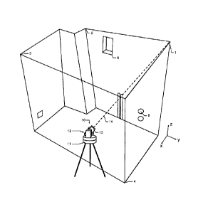
Figures 2, 3, 4 and 5 show in joint consideration the
measurement of a space having a plurality of walls and the
application of the functionality according to the invention
or of the method according to the invention, wherein for
example the spatial points 1, 2, 3, 4 have already been
measured and stored and further spatial points 5, 6 were
input by the user (e.g. by transferring external design data
to the evaluation and control unit) and are stored therein.
According to the invention, the construction measuring
appliance 10 has a representation-changing functionality, in
the context of which, depending on a line chosen by the user
from the lines displayed in the plan view representation (A)
or the spatial representation, automatically in a manner
controlled by the evaluation and control unit,
= a is defined the selected line and a direction
predefined as vertical,
= a subset of spatial points (1, 2, 3, 4) which lie
within a buffer zone (7) surrounding the virtual area
in a defined manner is selected from the spatial point
set, and
= an elevation representation (B) of exclusively such
spatial points (1, 2, 3, 4) which belong to the subset
is displayed on the display.
14
CA 02823273 2013-06-27
In other words, only spatial points situated within a
defined buffer zone 7 (see figure 4), said buffer zone being
defined by fixedly predefined (or predefinable) distances
from the area containing the selected line, are represented
in the evaluation representation (B). Those spatial points
from the entire spatial point set or those spatial points
illustrated in the initial representation which do not lie
within said buffer zone are filtered out before the change
to the elevation representation (B) and are not represented
there.
The buffer zone 7 (see figure 4) extends in front and
behind the virtual area as far as a defined maximum distance
from the virtual area, in particular wherein a value for the
maximum distance is fixedly predefined or can be predefined
by the user in a range of between 0 and 100 cm, specifically
in a range between 10 and 50 cm.
According to the invention, then, it is thus possible
to implement both the alignment and the type of
representational form of spatial points of a stored spatial
point set, and in particular in this respect also the
selection of the points to be selected for the elevation B,
in a single user work step, wherein the entire process is
sufficiently defined solely by the selection of the desired
line by the user.
This functionality - simple for the user to
operate - for changing between different modes of
representation of a space is primarily provided for use by a
regular craftsperson, that is to say is suitable in
particular for persons who are not specially trained or
experienced in measurement technology.
The initial situation for this newly provided
functionality is that conventional appliances with
conventional possibilities for representing the measurement
CA 02823273 2013-06-27
data usually present a superimposition - which is very
unclear for a user - of spatial points lying in common
vertical planes (e.g. ceiling and floor) with spatial points
lying in common horizontal planes (e.g. on different walls).
The new development functionality enables an operator to
change between view from above ("plan view A", in accordance
with figure 3) and lateral or frontal view ("elevation B",
in accordance with figure 5) of the stored measurement data,
in particular by selecting a line which connects measured
spatial points 1, 2 and which is intended to be contained in
the elevation representation B.
Therefore, an advantage of the invention is the rapid
visualization of the measurement geometry from different
views, namely plan view (A) and elevation (B), wherein in
particular the selection of the points to be represented in
elevation (B) - in order to avoid lack of clarity - is
performed automatically by using a predefined buffer zone.
Consequently, three-dimensional data such as arise e.g. from
the dimensioning of an interior can be converted into two
clear two-dimensional views.
View A (plan view representation) is characterized by
orthogonal projection of the points into a horizontal plane,
wherein a reference to the outer vertical or horizontal
direction can be established e.g. by the above-described
inclination sensor means or by prior calibration of an outer
reference assumed to he aligned precisely vertically or to
be aligned precisely horizontally.
The plan view representation A can therefore be
designated as a two-dimensional representation of spatial
points - projected onto a plane assumed to be aligned
horizontally.
16
CA 02823273 2013-06-27
View B (elevation representation) is characterized by
orthogonal projection of the points into a plane containing
the Z-axis of the coordinate system.
The elevation representation B can therefore be
designated as a two-dimensional representation of spatial
points - projected onto a plane assumed to be aligned
vertically.
Furthermore, the 2D elevation representation B is
predefined by a line to be selected by a user, for example
the connecting line between the spatial points 1 and 2. In
particular, this line can represent for example the edge of
a wall which runs approximately horizontally.
The line from point 1 to point 2 as displayed in the
plan view representation A in figure 2 could be selected by
the user, for example, by selection in the graphical user
interface (GUI) by means of arrow keys (or a trackball, a
touchpad, a trackpoint [pointing stick], etc.) or by
touching (tapping) a touchscreen, or by some other manner
appropriate for a GUI.
The plan view representation A (figure 3) thereupon
changes automatically then to the elevation view B (figure
5) and uses the selected line between the points 1 and 2 as
the direction determining the view B (i.e. in this case as
seen from the opposite wall of the space illustrated in
figure 2). At the same time, only those spatial points 1, 2,
5, 6 are displayed which lie within the buffer zone
surrounding the vertical area - containing the line 1-2 - as
far as a defined maximum distance. In this case, the buffer
zone 7 is defined here as the spatial region which extends
as far as a fixed maximum distance of e.g. 20 cm in front of
and behind the vertical area containing the line 1-2. In
this case, therefore, the buffer zone 7 is a column
extending in the vertical direction with the rectangular
17
CA 02823273 2013-06-27
area 7 illustrated in a hatched manner in figure 4 as the
cross-sectional area of the column, wherein the rectangular
area 7 surrounds the line 1-2 in such a way that the line
1-2 forms the mid-perpendicular (also called perpendicular
bisector) of the two longitudinal sides of the rectangular
area 7 and the distance from the two longitudinal sides to
the line 1-2 corresponds to the predefined (or predefinable
distance).
Without such a selection with the aid of the buffer
zone, the elevation view B would be unclear. By way of
example, the points 3 and 4 from the opposite wall - in the
case of an elevation representation of all detected spatial
points - would then also be represented, which might
adversely affect the benefit of a change of view with regard
to the readability of information about measured spatial
points and delay the dimension measuring process.
Figures 6 and 7 relate to a further aspect of the
invention, which can optionally be combined with the
above-described measuring apparatus or the above-described
method, but can also be employed totally separately from the
above-described representation-changing
functionality
according to the invention.
Figure 6 shows a system designed in accordance with
this further aspect of the invention and comprising a
construction measuring appliance 100 and three reference
point marks M, N, 0 which can be fitted in spaces. In this
system comprising a construction measuring appliance 100 for
measuring and marking spatial points in the context of
construction and/or development - in particular interior
finishing - of buildings and at least three reference point
marks K, L, M, N, 0 which can be fitted in spaces and which
each have a known pattern 30 indicating a discrete
reference point, the construction measuring appliance has a
base 110, and an upper part 120 mounted on the base 110 in
18
CA 02823273 2013-06-27
a manner rotatable about a rotation axis. Furthermore,
provision is made of a sighting unit 130, which is mounted
on the upper part 120 in a manner pivotable about a
pivoting axis and provides distance measuring
functionality, having a laser source designed to emit a
laser beam 140 in the direction of an aiming axis, and a
laser light detector and also having an integrated digital
camera aligned in the direction of the aiming axis.
Furthermore, the construction measuring appliance 100
comprises an evaluation and control unit having image
processing and storage means. In this case, a first and a
second rotary drive make the upper, part 120 and the
sighting unit 130 drivable and alignable, and a spatial
alignment of the sighting unit relative to the base 110 is
detectable by means of two goniometers. Furthermore, the
evaluation and control unit is connected to the laser
source, the laser light detector and also the goniometers
in such a way that a detected distance can be assigned to a
corresponding alignment and relative coordinates for
spatial points can thus be determined. In accordance with
the further aspect of the invention, the construction
measuring appliance 100 now has a referencing functionality
for referencing its own current location 42 and its own
current orientation relative to the reference points which
are situated within visual and measurement range of the
construction measuring appliance 100 and the absolute
positions of which in a desired coordinate system are
known, in particular already calibrated from a previous
location 41 and stored, wherein in the context of the
referencing functionality after initiation in a manner
automatically controlled by the evaluation and control unit
the following proceed: acquiring a plurality of camera
images in different alignments of the sighting unit 130
within a defined search field of view range, and evaluating
the acquired camera images by image processing with regard
to identifying the reference point marks K, L, M, N, 0 in
the acquired camera images on the basis of the respectively
19
CA 02823273 2013-06-27
known patterns thereof. This is additionally followed by
determining the respective image positions of the
identified reference point marks K, L, M, N, 0 in the
acquired camera images, and deriving solid angles with
respect to the reference points respectively indicated by
the reference point marks K, L, M, N, 0 identified in the
camera images on the basis of the respective image
positions of the reference point marks K, L, M, N, 0 and
the respective alignment of the sighting unit 130 in which
the respective camera image is acquired. This is likewise
followed by progressively moving to the solid angles
respectively derived for the reference points and
determining the respective relative coordinates of the
reference points, and referencing the own current location
42 and the own current orientation relative to the
reference points on the basis of the absolute positions
respectively known for the reference points in the desired
coordinate system and the relative coordinates respectively
determined for the reference points.
In the system, the reference point marks K, L, M, N, 0
each have a pattern carrier, on which the known pattern 30
is applied, in particular printed, and an identification
region provided on the pattern carrier and serving for
identifying the own individual identity of the respective
reference points, in particular wherein the identification
region is embodied as a printed identification number or as
a barcode or as a free field 31 provided for manual
inscription.
In particular, with the system, in the context of the
referencing functionality in addition to the step of
determining the respective image positions, the respective
identities of the reference points are determined by reading
out the respective identification regions of the reference
point marks K, L, M, N, 0 identified in the acquired camera
images with the aid of image processing, and the absolute
CA 02823273 2013-06-27
positions and the relative coordinates for the respective
reference points are assigned in pairs with the aid of the
determined identities of the reference points.
Furthermore, in the context of the referencing
functionality, it is possible to carry out pairwise
assignment of the absolute positions and of the relative
coordinates for the respective reference points in
accordance with a method from the publication
WO 2008/138541, wherein a referencing of a measuring
appliance 100 can be carried out on the basis of a spatial
distribution of known measurement points.
In addition, in the context of the referencing
functionality, for the steps of progressively moving to and
respectively determining the relative coordinates of the
reference points, a fine sighting method in accordance with
the European patent application having the application
number 10168771.3 can be employed, wherein, on the basis of
a known pattern 30, a reference point mark K, L, M, N, 0 can
be identified by means of image processing and the sighting
unit can be automatically aligned with a target point
situated in a known spatial relationship with respect to
said pattern.
In particular, a construction measuring appliance 100,
designed and provided for use in a system described above,
can therefore comprise a base 110, an upper part 120 mounted
on the base 110 in a manner rotatable about a rotation axis,
a sighting unit 130, which is mounted on the upper part 120
in a manner pivotable about a pivoting axis and provides
distance measuring functionality, having a laser source
designed to emit a laser beam 140 in the direction of an
aiming axis, and a laser light detector and also having an
integrated digital camera aligned in the direction of the
aiming axis, and an evaluation and control unit having image
processing and storage means. A first and a second rotary
21
CA 02823273 2013-06-27
drive make the upper part 120 and the sighting unit 130
drivable and alignable, a spatial alignment of the sighting
unit relative to the base 110 is detectable by means of two
goniometers, and the evaluation and control unit is
connected to the laser source, the laser light detector and
also the goniometers in order to assign a detected distance
to a corresponding alignment and thus to determine relative
coordinates for spatial points. The construction measuring
appliance 100 has a referencing functionality for
referencing its own current location 42 and its own current
orientation relative to reference points - indicated by
respectively known patterns of reference point marks which
are situated within visual and measurement range of the
construction measuring appliance 100 - the
absolute
positions of which in a desired coordinate system are known,
in particular already calibrated from a previous location 41
and stored, wherein in the context of the referencing
functionality after initiation in a manner automatically
controlled by the evaluation and control unit the following
proceed: acquiring a plurality of camera images in different
alignments of the sighting unit 130 within a defined search
field of view range, and evaluating the acquired camera
images by image processing with regard to identifying the
reference point marks in the acquired camera images on the
basis of the respectively known patterns thereof. This is
furthermore followed by determining the respective image
positions of the identified reference point marks in the
acquired camera images, and deriving solid angles with
respect to the reference points respectively indicated by
the reference point marks identified in the camera images on
the basis of the respective image positions of the reference
point marks and the respective alignment of the sighting
unit 130 in which the respective camera image is acquired.
There additionally proceed: progressively moving to the
solid angles respectively derived for the reference points
and determining the respective relative coordinates of the
reference points, and referencing the own current location
22
CA 02823273 2013-06-27
42 and the own current orientation relative to the reference
points on the basis of the absolute positions respectively
known for the reference points in the desired coordinate
system and the relative coordinates respectively determined
for the reference points.
Figure 7 shows a possible exemplary embodiment of two
reference point marks K, L
having a pattern 30 and
respectively a free field 31, in which a user can apply, in
particular paint, an individual pattern. With a system
comprising a construction measuring appliance 100 and
reference point marks K, L, in a search mode, a space can be
visually scanned (camera image) and, with the aid of image
processing, reference point marks K, L in range can be
sought and measured. For this purpose, by way of example, a
digital pattern 30 of a reference point mark K stored in the
data processing is compared with the camera images by an
autocorrelation technique. The sighting can likewise be
performed automatically by the system by virtue of the fact
that an autocorrelation determines a maximum of a
pattern-image correlation and, at a location which is in a
known spatial relationship with respect to a pattern 30,
e.g. a barcode, are carries out a distance measurement. In
this case, the barcode 30 can be identified during the
automatic search for the reference point 35 stored in the
database. Furthermore, the searching and sighting method can
be simplified starting from a third reference point 35, and
a transition can he made to selective searching (i.e. with
prior assumptions being made), since, from a provisional
standpoint already determined by means of two first
reference points 35, the search can be restricted to the
reference points 35 situated in the vicinity. In principle,
this search is also possible without precoded reference
point marks K. For this purpose, the user applies e.g. a
handwritten identification in the free field 31 of the
reference point marks L. This has the consequence that when
the coordinates of the check point 35 are stored, an image
23
CA 02823273 2013-06-27
of the identifier applied by the user is acquired and
concomitantly stored.
As already mentioned, however, even without any
measurement mark identifier - enabling
unique
identification - in principle it is possible to perform a
general search for the reference points from the database of
the potential reference points by comparing the measured
actual distances between the reference points - calibrated
anew after a change of location - with the desired distances
between the stored reference points which result from the
database coordinates, analogously to the method described in
the publication WO 2008/138541.
If a second such measuring appliance is situated in the
space, which appliance was stationed with the same geometry
and was not repositioned, the appliances can reestablish the
station of the repositioned appliance by mutual measurement.
If this is intended to take place automatically, two-way
communication of the appliances between one another is
required. Just for the redundancy and thus also for the
accuracy and reliability of determining the new
station - i.e. the new standpoint of the repositioned
appliance - it is then actually still necessary to carry out
sighting of reference points positioned in a known manner in
the previously defined coordinate system. In this case, the
method of searching for the known reference points is
simplified considerably because then once again - as already
described above - a selective search for the reference
points (i.e. taking account of the provisionally determined
standpoint of the repositioned appliance) can be applied.
Consequently, the search can thus be restricted to the
reference points 35 situated in the vicinity, or rough new
relative positions - i.e. viewed from the provisionally
determined standpoint - can already be determined for the
known reference points and be included for the search.
24
CA 02823273 2013-06-27
It goes without saying that these figures illustrated
only illustrate possible exemplary
embodiments
schematically. The various approaches can likewise be
combined with one another and also with methods from the
prior art.