Note: Descriptions are shown in the official language in which they were submitted.
CA 02826854 2013-08-07
WO 2012/109352 PCT/US2012/024325
THREE-DIMENSIONAL MODELING OF PARAMETERS FOR OILFIELD
DRILLING
BACKGROUND
[0001] Operations, such as surveying, drilling, wireline testing,
completions, production,
planning and field analysis, are typically performed to locate and gather
valuable downhole
fluids. Surveys are performed using acquisition methodologies, such as seismic
scanners or
surveyors to obtain data about underground formations. During drilling and
production
operations, data is typically collected for analysis and/or monitoring of the
operations. Such
data may include, for instance, information regarding subterranean formations,
equipment,
historical, and/or other data. Typically, simulators use the gathered data to
model specific
behavior of discrete portions of the wellbore operation.
SUMMARY
[0002] In general in one aspect, embodiments relate to a method for three-
dimensional
modeling of parameters for oilfield drilling. The method includes generating a
three-
dimensional model of an underground geological region, receiving a starting
point for the
oilfield drilling, calculating, using the three-dimensional model and an
objective function, a
drilling direction from the starting point, calculating, using the three-
dimensional model,
drilling densities for drilling from the starting point, and presenting the
drilling direction and
the drilling densities.
[0003] In general, in one aspect, embodiments relate to a system for three-
dimensional
modeling of parameters for oilfield drilling. The system includes an oilfield
three-
dimensional simulator application and an oilfield analysis application. The
oilfield three-
dimensional simulator application is configured to generate a three-
dimensional model of an
underground geological region. The oilfield analysis application is configured
to receive a
starting point for the oilfield drilling, calculate, using the three-
dimensional model and an
objective function, a drilling direction from the starting point, calculate,
using the three-
1
CA 02826854 2015-08-19
54866-9
dimensional model, drilling densities for drilling from the starting point,
and present the
drilling direction and the drilling densities.
[0004] In general, in one aspect, embodiments relate to a computer
readable medium
that includes computer readable program code embodied therein for causing a
computer
system to perform a method for three-dimensional modeling of parameters for
oilfield drilling.
The method includes generating a three-dimensional model of an underground
geological
region, receiving a starting point for the oilfield drilling, calculating,
using the three-
dimensional model and an objective function, a drilling direction from the
starting point,
calculating, using the three-dimensional model, drilling densities for
drilling from the starting
point, and presenting the drilling direction and the drilling densities.
[0004a] According to an aspect of the present invention, there is
provided a method
comprising: generating a three dimensional model of an underground geological
region;
receiving a starting point for drilling in the underground geological region;
calculating, using
the three-dimensional model and an objective function, a drilling direction
from the starting
point; calculating, using the three-dimensional model, drilling densities for
drilling from the
starting point, wherein calculating the drilling densities comprises:
calculating, using stress
information in the three-dimensional model, a stress distribution along a
borehole in the
drilling direction, and using the stress distribution to determine the
drilling densities; and
outputting the drilling direction and the drilling densities for use in
drilling a borehole.
[0004b1 According to another aspect of the present invention, there is
provided a
system comprising: a dimensional simulator application executable on a
computer processor
and configured to: generate a three dimensional model of an underground
geological region;
and an analysis application executable on the computer processor and
configured to: receive a
starting point for drilling in the underground geological region; calculate,
using the three-
dimensional model and an objective function, a drilling direction from the
starting point;
calculate, using the three-dimensional model, drilling densities for drilling
from the starting
point, wherein calculating the drilling densities comprises: calculating,
using stress
information in the three-dimensional model, a stress distribution along a
borehole in the
2
CA 02826854 2015-08-19
54866-9
drilling direction, and using the stress distribution to determine the
drilling densities; and
output the drilling direction and the drilling densities for use in drilling a
borehole.
[0004c] According to still another aspect of the present invention,
there is provided a
computer program product comprising a computer readable memory storing
computer
executable instructions thereon that when executed by a computer perform a
method
described above or below.
[0005] This summary is provided to introduce a selection of concepts
that are further
described below in the detailed description. This summary is not intended to
identify key or
essential features of the claimed subject matter, nor is it intended to be
used as an aid in
limiting the scope of the claimed subject matter. Other aspects will be
apparent from the
following description and the appended claims.
BRIEF DESCRIPTION OF DRAWINGS
[0006] FIG. 1 shows an example system in which embodiments of three-
dimensional
modeling may be implemented.
[0007] FIG. 2 shows an example system in which embodiments of three-
dimensional
modeling may be implemented.
[0008] FIG. 3 shows an example computer system in which embodiments
of three-
dimensional modeling may be implemented.
[0009] FIG. 4 shows an example system in which embodiments of three-
dimensional
modeling may be implemented.
2a
CA 02826854 2013-08-07
WO 2012/109352 PCT/US2012/024325
[0010] FIG. 5 shows an example method for three-dimensional modeling in one or
more
embodiments.
[0011] FIG. 6 shows an example method of calculating drilling direction for
three-
dimensional modeling in one or more embodiments.
[0012] FIG. 7 shows an example method of calculating drilling densities for
three-
dimensional modeling in one or more embodiments.
[0013] FIGs. 8.1-8.4 show example graphical diagrams in one or more
embodiments.
DETAILED DESCRIPTION
[0014] Specific embodiments will now be described in detail with reference to
the
accompanying figures. Like elements in the various figures are denoted by like
reference
numerals for consistency.
[0015] In the following detailed description of embodiments, numerous specific
details are
set forth in order to provide a more thorough understanding of the invention.
However, it will
be apparent to one of ordinary skill in the art that the invention may be
practiced without these
specific details. In other instances, well-known features have not been
described in detail to
avoid unnecessarily complicating the description.
[0016] In general, embodiments provide a method and apparatus for three-
dimensional
modeling of parameters for oilfield drilling. Specifically, embodiments
generate a three-
dimensional model of an underground geological region. Using the three-
dimensional model,
embodiments calculate an optimal drilling direction and drilling densities
from a provided
starting point in the underground geological region. The drilling direction
and drilling
densities may be used to drill a well in the oilfield. For example,
embodiments may drill the
well by transmitting the drilling direction and drilling densities to a
surface unit that sends a
signal to a drilling tool with the drilling direction and drilling densities.
1063250_2 3
CA 02826854 2013-08-07
WO 2012/109352 PCT/US2012/024325
[0017] FIG. 1 shows an example system in which embodiments of three-
dimensional
modeling may be implemented. Specifically, FIG. 1 is a schematic view of a
wellsite (100)
depicting a drilling operation. In one or more embodiments, drilling tools are
deployed from
the oil and gas rigs. The drilling tools advanced into the earth along a path
to locate reservoirs
containing the valuable downhole assets. In one or more embodiments, the
optimal path for
the drilling is identified using the three-dimensional modeling. Specifically,
in one or more
embodiments, the three-dimensional model is partitioned into a three-
dimensional grid of
cells. Each cell may be a cube in the model. In one or more embodiments, a
drilling direction
is calculated for each cell in the model while accounting for neighboring
cells. The path is
defined by drilling in the drilling direction from a starting cell to a
neighboring cell, then
drilling in the drilling direction defined for the neighboring cell to a
subsequent neighboring
cell, then drilling in the drilling direction for the subsequent neighboring
cell to another
neighboring cell, etc.
[0018] Fluid, such as drilling mud or other drilling fluids, is pumped down
the wellbore (or
borehole) through the drilling tool and out the drilling bit. In one or more
embodiments, the
amount of fluid pumped into the well is defined by the drilling density.
Specifically, the
drilling density is the upper and lower bounds of equivalent hydraulic
pressure acting over
borehole walls to create failure of the borehole. Because the amount and type
of fluid directly
affects the hydraulic pressure on the borehole walls, calculating the drilling
density and using
the drilling density defines the amount and type of fluid to pump down the
wellbore.
Continuing with the discussion of FIG. 1, the drilling fluid flows through the
annulus between
the drilling tool and the wellbore and out the surface, carrying away earth
loosened during
drilling. The drilling fluids return the earth to the surface, and seal the
wall of the wellbore to
prevent fluid in the surrounding earth from entering the wellbore and causing
a 'blow out'.
[(10191 During the drilling operation, the drilling tool may perform downhole
measurements
to investigate downhole conditions. The drilling tool may be used to take core
samples of
subsurface formations. In some cases, the drilling tool is removed and a
wireline tool is
deployed into the wellbore to perform additional downhole testing, such as
logging or
1063250_2 4
CA 02826854 2013-08-07
WO 2012/109352 PCT/US2012/024325
sampling. Steel casing may be run into the well to a desired depth and
cemented into place
along the wellbore wall. Drilling may be continued until the desired total
depth is reached.
100201 A formation is in an underground geological region. An underground
geological
region is a geographic area that exists below land or ocean. In one or more
embodiments, the
underground geological region includes the subsurface formation in which a
borehole is or
may be drilled and any subsurface region that may affect the drilling of the
borehole, such as
because of stresses and strains existing in the subsurface region. In other
words, the
underground geological region may not only include the area immediately
surrounding a
borehole or where a borehole may be drilled, but also any area that affects or
may affect the
borehole or where the borehole may be drilled.
100211 After the drilling operation is complete, the well may then be prepared
for
production. Wellbore completions equipment is deployed into the wellbore to
complete the
well in preparation for the production of fluid through the wellbore. Fluid is
then allowed to
flow from downhole reservoirs, into the wellbore and to the surface.
Production facilities are
positioned at surface locations to collect the hydrocarbons from the
wellsite(s). Fluid drawn
from the subterranean reservoir(s) passes to the production facilities via
transport
mechanisms, such as tubing. Various equipments may be positioned about the
oilfield to
monitor oilfield parameters, to manipulate the oilfield operations and/or to
separate and direct
fluids from the wells. Surface equipment and completion equipment may also be
used to
inject fluids into reservoir either for storage or at strategic points to
enhance production of the
reservoir.
100221 During the oilfield operations, data is typically collected for
analysis and/or
monitoring of the oilfield operations. Such data may include, for example,
subterranean
formation, equipment, historical and/or other data. Data concerning the
subterranean
formation is collected using a variety of sources. Such formation data may be
static or
dynamic. Static data relates to, for example, formation structure and
geological stratigraphy
that define the geological structures of the subterranean formation. Dynamic
data relates to,
for example, fluids flowing through the geologic structures of the
subterranean formation over
1063250_2 5
CA 02826854 2013-08-07
WO 2012/109352 PCT/US2012/024325
time. Such static and/or dynamic data may be collected to learn more about the
formations
and the valuable assets contained therein. Specifically, the static and
dynamic data collected
from the wellbore and the oilfield may be used to create and update the three-
dimensional
model. Additionally, static and dynamic data from other wellbores or oilfields
may be used to
create and update the three-dimensional model. Hardware sensors, core
sampling, and well
logging techniques may be used to collect the data. Other static measurements
may be
gathered using downhole measurements, such as core sampling and well logging
techniques.
Well logging involves deployment of a downhole tool into the wellbore to
collect various
downhole measurements, such as density, resistivity, etc., at various depths.
Such well
logging may be performed using, for example, the drilling tool and/or a
wireline tool. Once
the well is formed and completed, fluid flows to the surface using production
tubing and other
completion equipment. As fluid passes to the surface, various dynamic
measurements, such
as fluid flow rates, pressure, and composition may be monitored. These
parameters may be
used to determine various characteristics of the subterranean formation.
[0023] Continuing with FIG. 1, the wellsite system (100) includes a
drilling system (111)
and a surface unit (134). In the illustrated embodiment, a borehole (113) is
formed by rotary
drilling in a manner that is well known. Although rotary drilling is shown,
embodiments also
include drilling applications other than conventional rotary drilling (e.g.,
mud-motor based
directional drilling), and is not limited to land-based rigs. For example,
embodiments may be
used to perform three-dimensional modeling and drilling of a deep water
operation.
[0024] The drilling system (111) includes a drill string (115) suspended
within the borehole
(113) with a drill bit (110) at its lower end. The drilling system (111) also
includes the land-
based platform and derrick assembly (112) positioned over the borehole (113)
penetrating a
subsurface formation (F). The assembly (112) includes a rotary table (114),
kelly (116), hook
(118) and rotary swivel (119). The drill string (115) is rotated by the rotary
table (114),
energized by means not shown, which engages the kelly (116) at the upper end
of the drill
string. The drill string (115) is suspended from hook (118), attached to a
traveling block (also
not shown), through the kelly (116) and a rotary swivel (119) which permits
rotation of the
drill string relative to the hook.
1063250_2 6
CA 02826854 2013-08-07
WO 2012/109352 PCT/US2012/024325
[0025] The drilling system (111) further includes drilling fluid or mud
(120) stored in a pit
(122) formed at the well site. A pump (124) delivers the drilling fluid (120)
to the interior of
the drill string (115) via a port in the swivel (119), inducing the drilling
fluid to flow
downwardly through the drill string (115) as indicated by the directional
arrow (125). The
drilling fluid exits the drill string (115) via ports in the drill bit (110),
and then circulates
upwardly through the region between the outside of the drill string and the
wall of the
borehole, called the annulus (126). In this manner, the drilling fluid
lubricates the drill bit
(110) and carries formation cuttings up to the surface as it is returned to
the pit (122) for
recirculation.
[0026] The drill string (115) further includes a bottom hole assembly (BHA),
generally
referred to as (130), near the drill bit (110) (in other words, within several
drill collar lengths
from the drill bit). The bottom hole assembly (130) includes capabilities for
measuring,
processing, and storing information, as well as communicating with the surface
unit. The
BHA (130) further includes drill collars (128) for performing various other
measurement
functions.
[0027] Sensors (S) are located about the wellsite to collect data, may be
in real time,
concerning the operation of the wellsite, as well as conditions at the
wellsite. The sensors
may also have features or capabilities, of monitors, such as cameras (not
shown), to provide
pictures of the operation. Surface sensors or gauges S may be deployed about
the surface
systems to provide information about the surface unit, such as standpipe
pressure, hook load,
depth, surface torque, rotary rpm, among others. Downhole sensors or gauges
(S) are
disposed about the drilling tool and/or wellbore to provide information about
downhole
conditions, such as wellbore pressure, weight on bit, torque on bit,
direction, inclination,
collar rpm, tool temperature, annular temperature, and toolface, among others.
The
information collected by the sensors and cameras is conveyed to the various
parts of the
drilling system and/or the surface control unit.
[0028] The drilling system (110) is operatively connected to the surface
unit (134) for
communication therewith. The BHA (130) is provided with a communication
subassembly
1063250_2 7
CA 02826854 2015-04-14
54866-9
(152) that communicates with the surface unit (134). The communication
subassembly (152)
is adapted to send signals to and receive signals from the surface using mud
pulse telemetry.
The communication subassembly may include, for example, a transmitter that
generates a
signal, such as an acoustic or electromagnetic signal, which is representative
of the measured
drilling parameters. Communication between the downhole and surface systems is
depicted
as being mud pulse telemetry. However, a variety of telemetry systems may be
employed,
such as wired drill pipe, electromagnetic or other known telemetry systems.
[0029] Typically, the wellbore is drilled according to a drilling plan
that is established prior
to drilling. The drilling plan typically sets forth equipment, pressures,
trajectories and/or
other parameters that define the drilling process for the wellsite. The
drilling operation may
then be performed according to the drilling plan. However, as information is
gathered, the
drilling operation may deviate from the drilling plan. Additionally, as
drilling or other
operations are performed, the subsurface conditions may change. The three-
dimensional
model may also be adjusted as new information is collected, such as from
sensors.
Specifically, as new information is collected, the sensors may transmit data
to the surface unit.
The surface unit may automatically use the data to update the three-
dimensional model.
[0030] FIG. 2 shows a schematic diagram depicting drilling operation of a
directional well
in multiple sections. The drilling operation depicted in FIG. 2 includes a
wellsite drilling
system (200) and a computer system (220) for accessing fluid in the target
reservoir through a
bore hole (250) of a directional well (217). The wellsite drilling system
(200) includes
various components (e.g., drill string (212), annulus (213), bottom hole
assembly (BHA)
(214), Kelly (215), mud pit (216), etc.) as generally described with respect
to the wellsite
drilling systems (100) (e.g., drill string (115), annulus (126), bottom hole
assembly (BHA)
(130), Kelly (116), mud pit (122), etc.) of FIG. 1 above. As shown in FIG. 2,
the target
reservoir may be located away from (as opposed to directly under) the surface
location of the
well (217). Accordingly, special tools or techniques may be used to ensure
that the path along
the bore hole (250) reaches the particular location of the target reservoir.
8
CA 02826854 2015-04-14
54866-9
[0031] For example, the BHA (214) may include sensors (208), rotary steerable
system
(209), and the bit (210) to direct the drilling toward the target guided by a
pre-determined
survey program for measuring location details in the well. Furthermore, the
subterranean
formation through which the directional well (217) is drilled may include
multiple layers (not
shown) with varying compositions, geophysical characteristics, and geological
conditions.
Both the drilling planning during the well design stage and the actual
drilling according to the
drilling plan in the drilling stage may be performed in multiple sections
(e.g., sections (201),
(202), (203), (204)) corresponding to the multiple layers in the subterranean
formation. For
example, certain sections (e.g., sections (201) and (202)) may use cement
(207) reinforced
casing (206) due to the particular formation compositions, geophysical
characteristics, and
geological conditions.
[0032]
Further as shown in FIG. 2, surface unit (211) (as generally described with
respect to
the surface unit (134) of FIG. 1) may be operatively linked to the wellsite
drilling system
(200) and the computer system (220) via communication links (218). The surface
unit (211)
may be configured with functionalities to control and monitor the drilling
activities by
sections in real-time via the communication links (218). The computer system
(220) may be
configured with functionalities to store oilfield data (e.g., historical data,
actual data, surface
data, subsurface data, equipment data, geological data, geophysical data,
target data, anti-
target data, etc.) and determine relevant factors for configuring a drilling
model and
generating a drilling plan. The oilfield data, the drilling model, and the
drilling plan may be
transmitted via the communication link (218) according to a drilling operation
workflow. The
communication link (218) may comprise the communication subassembly as
described
with respect to FIG. 1 above.
[0033] The computer system (220 in FIG. 2) may be virtually any type of
computer
regardless of the platform being used. For example, as shown in FIG. 3, a
computer system
(220) includes one or more hardware processor(s) (302), associated memory
(304) (e.g.,
random access memory (RAM), cache memory, flash memory, etc.), a storage
device (306)
(e.g., a hard disk, an optical drive such as a compact disk drive or digital
video disk (DVD)
drive, a flash memory stick, etc.), and numerous other elements and
functionalities typical of
9
CA 02826854 2015-04-14
54866-9
today's computers (not shown). The computer system (220) may also include
input means, such as a
keyboard (308), a mouse (310), or a microphone (not shown). Further, the
computer system (220)
may include output means, such as a monitor (312) (e.g., a liquid crystal
display (LCD), a
plasma display, or cathode ray tube (CRT) monitor). The computer system (220)
may be
connected to a network (314) (e.g., a local area network (LAN), a wide area
network (WAN)
such as the Internet, or any other type of network) via a network interface
connection (not
shown). Those skilled in the art will appreciate that many different types of
computer
systems exist, and the aforementioned input and output means may take other
forms.
Generally speaking, the computer system (220) includes at least the minimal
processing,
input, and/or output means necessary to practice embodiments.
10034] Further, one or more elements of the aforementioned computer system
(220) may be
located at a remote location and connected to the other elements over a
network. Further,
embodiments may be implemented on a distributed system having a multiple
nodes, where
each portion of embodiments of three-dimensional modeling (e.g., reservoir
simulator,
geomechanical simulator, oilfield analysis application, oilfield three-
dimensional simulation
application, storage repository, etc.) may be located on a different node
within the distributed
system. In one embodiment, the node corresponds to a computer system.
Alternatively, the
node may correspond to a processor with associated physical memory. The node
may
alternatively correspond to a processor or micro-core of a processor with
shared memory
and/or resources.
[00351 Further, computer readable program code to perform one or more of the
various
components of the system may be stored, permanently or temporarily, in whole
or in part, on
a non-transitory computer readable medium such as a compact disc (CD), a
diskette, a tape,
physical memory, or any other physical computer readable storage medium that
includes
functionality to store computer readable program code to perform embodiments.
In one or
more embodiments, the computer readable program code is configured to perform
embodiments when executed by a processor(s).
CA 02826854 2013-08-07
WO 2012/109352 PCT/US2012/024325
[0036] FIG. 4 shows an example computer system (402) in which embodiments of
three-
dimensional modeling may be implemented. Specifically, the computer system
(402) shown
in FIG. 4 may be the computer system shown in FIG. 3. As shown in FIG. 4 and
discussed
above, the computer system (402) may be operatively connected to the oilfield
(400). In other
words, the computer system (402) may be directly or indirectly connected to
the oilfield (400)
using one or more communication links. Communication links include
functionality to
transmit data (e.g., sensor data and execution conditions) from the oilfield
(400) to the
computer system (402) and data (e.g., commands, parameters, etc.) from the
computer system
(402) to the oilfield (400). The oilfield (400) includes drilling equipment
(406) and a surface
unit (408). The drilling equipment (406) may include the components of FIGs. 1
and 2
corresponding to equipment for drilling the borehole (e.g., mud pit, kelly,
bottom hole
assembly, sensors, rotary swivel, drill collars, communication sub assembly,
etc.). As
discussed above with respect to FIGs. 1 and 2, the drilling equipment (406) is
operatively
connected to the surface unit (408). The surface unit (408) may be the surface
unit discussed
above with reference to FIGs. 1 and 2.
[0037] Continuing with FIG. 3, the computer system (402) may also include
functionality,
such as through one or more software and hardware user interfaces, to
communicate with user
(404). User (404) may be, for example, a geological engineer, a drilling
engineer, or another
person that provides input to the computer system and receives output. The
computer system
(402) includes a storage repository (410), an oilfield analysis application
(412), and an oilfield
three-dimensional model (414) in one or more embodiments.
[0038] The storage repository (410) is any type of storage unit and/or
device (e.g., a file
system, database, collection of tables, or any other storage mechanism) for
storing data.
Further, the storage repository (410) may include multiple different storage
units and/or
devices. The multiple different storage units and/or devices may or may not be
of the same
type or located at the same physical site. In one or more embodiments of the
invention, the
storage repository (410), or a portion thereof, is secure.
1063250_2 11
CA 02826854 2013-08-07
WO 2012/109352 PCT/US2012/024325
[0039] The storage repository (410) includes functionality to store
geological data for the
oilfield (416), seismic logs and/or core information (418), pore pressure
change effects (420),
and a three-dimensional model (422). Geological data (416) includes data
regarding the type
of rock and minerals in the formation, layout of the rock and other minerals
in the formation,
existing stresses and fractures, porosity of the rock, hydraulic conditions,
geologic and
structural features, and other geological information about the underground
geological region.
[0040] In one or more embodiments, seismic logs and/or core information
include
information gathered while performing surveying operations of the geological
region. For
example, as discussed above, seismic logs may include data gathered by a
seismic truck that
transmits sound vibrations. The sound vibrations reflect off of horizons in a
formation. The
reflected sound vibration(s) is (are) received in by sensors, such as geophone-
receivers,
situated on the earth's surface, and the sensors produce electrical output
signals (e.g., seismic
logs) that may automatically be populated into the storage repository (410).
[0041] In one or more embodiments, core information is information gathered by
taking a
physical sample (i.e., core sample) of the geological region. For example,
core information
may include the density, porosity, permeability or other physical property of
the core sample
over the length of the core sample. Core information may also include indirect
information,
such as by performing tests for density and viscosity on the fluids in the
core sample at
varying pressures and temperatures.
[0042] In one or more embodiments, pore pressure change effects are estimated
reductions
or increases in pore pressure that may be caused by either injections or
depletions. Pore
pressure is the amount of force being exerted into the borehole by fluid
and/or gases within
the geological region. In one or more embodiments, pore pressure change
effects (420)
corresponds to output from the reservoir simulator (426) (discussed below) and
may be used
as input to the geomechanical simulator (428).
[0043] In one or more embodiments, the three-dimensional model (422) models
the
geographic region, including providing information about stresses, strains,
and deformations,
geologic structures and features, temperature and pressure information, and
other such
1063250_2 12
CA 02826854 2013-08-07
WO 2012/109352 PCT/US2012/024325
information. As discussed above, the three-dimensional model (422) is
partitioned into three-
dimensional cells. The three-dimensional model (422) reflects how changes in
each cell
affects other cells in the model.
[0044] Continuing with FIG. 4, the storage repository is connected to an
oilfield analysis
application (412) and an oilfield three-dimensional simulator application
(414) in one or more
embodiments. The oilfield analysis application (412) is a software application
that includes
functionality to analyze an oilfield. For example, the oilfield analysis
application may include
functionality to prepare received data for the simulators. Specifically, the
oilfield analysis
application (412) includes functionality to access data in the storage
repository (410) and to
populate the storage repository (410). Populating the storage repository (410)
may include
obtaining sensor data from the oilfield (400), performing preprocessing on the
sensor data,
and storing the preprocessed sensor data in the storage repository (410).
[0045] The oilfield analysis application (412) may further include
functionality to analyze
output data from the oilfield three-dimensional simulator application (414).
For example, the
oilfield analysis application (412) may include functionality to perform
additional
simulations, such as by simulating an oilfield network of wellsites where
wells are
interconnected by pipes.
[0046] In one or more embodiments, the oilfield three-dimensional simulator
application
(414) includes functionality to construct the three-dimensional model (422)
and identify
drilling direction and drilling densities using the three-dimensional model
(428). The oilfield
three-dimensional simulator application (414) includes a visualization engine
(424), a
reservoir simulator (426), and a geomechanical simulator (428).
[0047] The visualization engine (424) is a user interface that allows the user
to interact with
the three-dimensional model. For example, using the visualization engine
(424), the user may
expand and rotate the three-dimensional model, analyze particular cells of the
three-
dimensional model, and view different types of data presented in the three-
dimensional
model. Further, using the visualization engine (424), the user may adjust data
in the three-
dimensional model. For example, if the user has particular knowledge of a
stress or strain in
1063250_2 13
CA 02826854 2013-08-07
WO 2012/109352 PCT/US2012/024325
the geologic region that is not reflected in the three-dimensional model, then
visualization
engine (424) provides graphical functionality for the user may adjust the
three-dimensional
model. Additionally, in one or more embodiments, the visualization engine
(424) includes
functionality to display a proposed path of the wellbore through the three-
dimensional model
as defined by the drilling direction and drilling densities. With the proposed
path, the
visualization engine may also show stresses, strains, and deformations in the
geological
region that are preexistent and stresses, strains, and deformations that may
result by drilling
the proposed path using the drilling densities.
[0048] The reservoir simulator (426) includes functionality to generate the
three-
dimensional model. Specifically, the reservoir simulator includes
functionality to generate an
initial three-dimensional model that shows stresses, strains, and
deformations, compare the
three-dimensional model with observed conditions of the wellbore or other
similar wellsites,
and calibrate the three-dimensional model to match the observed conditions. In
one or more
embodiments, the reservoir simulator (426) includes functionality to simulate
the changes in
pore pressure caused by injections and/or depletions of the reservoir.
[0049] The geomechanical simulator (428) includes functionality to use the
three-
dimensional model to calculate the optimal drilling direction and drilling
densities.
Specifically, the geomechanical simulator (428) includes functionality to
identify based on the
stresses, strains, and deformations, an optimal path in the three-dimensional
model. The
geomechanical simulator (428) further includes functionality to calculate
drilling densities for
fluid or gas pumped into the wellbore to prevent collapse of the wellbore. The
geomechanical
simulator (428) includes functionality to perform the aforementioned tasks
while
simultaneously accounting for the geological conditions of the surrounding
region.
[0050] While FIGs. 1-4 show a configuration of components, other
configurations may be
used without departing from the scope of three-dimensional modeling. For
example, various
components may be combined to create a single component. As another example,
the
functionality performed by a single component may be performed by two or more
components.
1063250_2 14
CA 02826854 2013-08-07
WO 2012/109352 PCT/US2012/024325
[0051] FIGs. 5-7 show flowcharts in one or more embodiments of three-
dimensional
modeling. While the various components in these flowcharts are presented and
described
sequentially, one of ordinary skill will appreciate that some or all of the
components may be
executed in different orders, may be combined or omitted, and some or all of
the components
may be executed in parallel. Furthermore, the components may be performed
actively or
passively. For example, some components may be performed using polling or be
interrupt
driven in accordance with one or more embodiments of the invention. By way of
an example,
a determination may not require a processor to process an instruction unless
an interrupt is
received to signify that condition exists in accordance with one or more
embodiments of the
invention. As another example, a determination may be performed by performing
a test, such
as checking a data value to test whether the value is consistent with the
tested condition in
accordance with one or more embodiments.
[0052] FIG. 5 shows a flowchart for three-dimensional modeling in one or more
embodiments. In FIG. 5, components 501-509 show generating a three-dimensional
model in
one or more embodiments. Components 511-521 show using the three-dimensional
model in
one or more embodiments.
[0053] In 501, a one dimensional model is created in one or more embodiments.
A one-
dimensional model is a model of stresses, strains, and deformations only along
a particular
path of a wellbore. In one or more embodiments, the one-dimensional model does
not
account for stresses or strains outside of the path of the wellbore. Creating
the one
dimensional model may be performed by simulating the effects of drilling in a
particular
drilling direction on the formation. Stress modeling along a well may be
performed by using
analytical equations that, based on the rock elastic properties, produces a
stress profile that
transforms the acting vertical stress (a function of depth and rock density)
into horizontal
stress (the rock elastic properties related the acting vertical stress and
pore pressure with the
acting horizontal stresses). Once the stress profile is obtained, well failure
may be computed
based on additional rock strength properties. The well stress profile or rock
properties are
adjusted until the predicted wellbore failures match the observed (e.g., after
logging the well)
failures the well experienced during drilling.
1063250_2 15
CA 02826854 2013-08-07
WO 2012/109352 PCT/US2012/024325
[0054] In 503, the one dimensional model is adjusted to obtain information for
the three-
dimensional model in one or more embodiments. In 505, using the information,
the three-
dimensional model is built to compute stresses and strains in one or more
embodiments.
Specifically, the three-dimensional model concatenates data from the seismic
logs and cores,
the geological data, and the information gathered from the one-dimensional
model. The
simulator may use industry standard concepts and formulae along with other
algorithms to
model rock formation behavior based on existing observational data. For
example, the Finite
Element Method (FEM) is a technique of numerical analysis in which a continuum
is
represented as a series of discrete elements represented by nodes and volumes.
The simulator
engine may apply FEM techniques to problems of stress in geo-mechanics. The
simulator
computes stress effects across a continuous rock formation by perform multiple
calculations
for points and volumes in an imaginary three-dimensional mesh (grid).
[0055] In 507, from the three-dimensional model, a synthetic one-dimensional
model is
extracted along a wellbore trajectory (i.e., path of existing wellbore) to
obtain predicted
events along the wellbore trajectory. In particular, an actual wellbore from
an existing oilfield
is identified. The actual wellbore may be, for example, near the wellbore to
be drilled or a
first part of a wellbore to be drilled. The position of the actual wellbore
trajectory with
respect to the three-dimensional model is identified. For example, the
coordinates of the
actual wellbore with respect to the earth may be identified. Based on the
coordinates, the
synthetic wellbore trajectory that matches the coordinates in the three-
dimensional model is
identified and extracted. The synthetic wellbore trajectory includes predicted
events, such as
stresses and strains in the geological region that occur naturally or would be
caused by the
drilling of the wellbore. At each depth of interest along a well, such as
every ten meters along
a well, the well location in three-dimensional (3D) space is used to search
for the cell (i.e.,
element) of the 3D model that contains such point. Once found, the stress,
pore pressure and
rock mechanical data (elastic and failure parameters) may be assigned to the
wellbore at
searched location. Once this action is performed along the whole interest
interval, the well
contains sufficient data for any process involving the computation of wellbore
stability.
1063250_2 16
CA 02826854 2013-08-07
WO 2012/109352 PCT/US2012/024325
[0056] In 509, a determination is made whether the predicted events are within
a threshold
of the actual events along the existing wellbore trajectory. Specifically, a
determination is
made as to whether the synthetic wellbore trajectory accurately captures
actual data gathered
from an existing wellbore trajectory. By comparing the actual events with
predicted events,
the accuracy of the three-dimensional model may be determined.
[0057] By way of an example, consider the scenario in which an actual event
shows that a
particular region of the wellbore shows a stress of a particular magnitude. In
the example, the
same particular region in the synthetic one dimensional model may not have a
stress or may
show a stress of considerably lower magnitude than the one in the actual
event. In such a
scenario, the predicted events may be determined to not be within the
threshold of the actual
events. As another example, the predicted events may show one or more stresses
or strains
that are not in the actual events. In such a scenario, the predicted events
may be determined
to not be within the threshold of the actual events.
[0058] In contrast, as another example, if most or all of the predicted events
are in the actual
events and of the same magnitude, and most or all of the actual events are
reflected in the
predicted events and of the same magnitude, then the three-dimensional model
may be
determined to be accurate.
[0059] In 509, if the predicted events are not within a threshold of the
actual events along
the existing wellbore trajectory, the flow may proceed to 503. If the
predicted events are not
within a threshold of the actual events along the existing wellbore
trajectory, the flow may
proceed to 511.
[0060] In 511, an identifier of the starting point in the three-dimensional
model is obtained.
The starting point is the point in the oilfield from which the drilling
direction and drilling
densities are defined. For example, if drilling of a borehole has not started,
the starting point
may be at the surface of the earth at a particular geographic location (e.g.,
specified by
longitude and latitude, Geopositioning system coordinates, or other
coordinates). As another
example, if the drilling of a borehole is in progress, or the first part of
the drilling of the
borehole is already planned, the starting point may be below the surface of
the earth. In such
1063250_2 17
CA 02826854 2013-08-07
WO 2012/109352 PCT/US2012/024325
a scenario, the starting point may be specified, for example, by coordinates
and depth. In one
or more embodiments, the starting point may be specified by the user or
automatically
obtained, such as by the surface unit. For example, the surface unit may
provide the current
location of the end of the borehole or where the drilling is to occur as the
starting point.
[0061] In 513, using the three-dimensional model and an objective function, a
drilling
direction is calculated from the starting point that minimizes stress or
contrast between
stresses in one or more embodiments. Specifically, the drilling direction that
is calculated
minimizes the amount of stress caused by drilling in the geographic region.
Because the
three-dimensional model is used to calculate drilling direction, not only are
stresses and
geologic formations along the path of the proposed borehole considered, but
also other
geologic features from entire geographic region are considered. In other
words, the three-
dimensional model provides a more comprehensive view of the earth's
formations.
Calculating a drilling direction is discussed below and in FIG. 6.
[0062] Continuing with FIG. 5, in 515, drilling densities are calculated
using the three-
dimensional model in one or more embodiments. The drilling density is the
upper and lower
bounds of equivalent hydraulic pressure acting over the borehole walls to
create rock failure.
In other words, the drilling density provides the minimum and maximum amount
of
mudweight that should be pumped when drilling in the drilling direction.
Calculating the
drilling densities is discussed below and in FIG. 7.
[0063] Continuing with FIG. 5, in 517, the drilling direction and the
drilling densities are
presented to the user in one or more embodiments. In one or more embodiments,
the drilling
densities and the drilling direction are presented by the visualization engine
showing the
three-dimensional model with the drilling direction and drilling densities.
Thus, the user may
view the drilling direction and drilling densities with graphic
representations of other geologic
formations and information about geologic formations to determine whether the
drilling
direction and the drilling densities should be approved.
[0064] In 519, a determination is made whether the drilling direction and the
drilling
densities are approved in one or more embodiments. Specifically, a
determination is made
1063250_2 18
CA 02826854 2013-08-07
WO 2012/109352 PCT/US2012/024325
whether the user approves of the drilling direction and the drilling
densities. In one or more
embodiments, the user may approve the drilling direction and drilling
densities by selecting a
user interface component of the visualization engine. The user that approves
or disapproves
of the drilling direction and the drilling densities may or may not be the
same user that
provides the starting point or another user that provides input to the
computer system. If the
user disapproves of the drilling direction and drilling densities, the flow
proceeds to 513 in
one or more embodiments. Although not shown in FIG. 3, if only disapproval of
the drilling
densities is received, then only the drilling densities may be recalculated.
If the user approves
of both the drilling direction and the drilling densities, the flow proceeds
to 521 in one or
more embodiments.
[0065] In
521, the oilfield is drilled in the drilling direction at the starting point
using the
drilling densities and according to the three-dimensional model in one or more
embodiments.
In other words, the calculations, which use the three-dimensional model, are
directly used to
drill the borehole, and eventually produce hydrocarbons in one or more
embodiments.
Drilling may include the computer system sending the drilling densities to the
surface unit.
The surface unit may provide instructions to the drilling equipment at the
oilfield with the
parameters of drilling. In one or more embodiments, the drilling direction and
drilling
densities may be provided to a user that may provide the information to the
oilfield. In one or
more embodiments, the drilling direction and drilling densities may be
provided to the oilfield
analysis application that may use the information for additional oilfield
analysis.
[0066] FIG. 6 shows a flowchart for calculating drilling directions in one or
more
embodiments. Specifically, FIG. 6 shows only one example for calculating
drilling directions
in one or more embodiments. Other methods for calculating drilling directions
may be used
without departing from the scope of the claims.
[0067] In one or more embodiments, the details of the calculation involve
minimizing the
maximum principal stress, maximizing the minimum principal stress or
minimizing the
contrast between the maximum principal stress and the mimimum principal
stress, as a
function of wellbore deviation and azimuth. In
one or more embodiments, the
1063250_2 19
CA 02826854 2013-08-07
WO 2012/109352 PCT/US2012/024325
aforementioned stresses are evaluated at the face of the borehole wall for a
specific depth. An
example function to minimize would be equation for hoop stress around a
borehole:
R,4õ\
R4 \
4'.*"14;' CT; - 42: , "
gt.7 = =7. t, 1- T.F.7 ;, 1+ =; sin
7
[0068] In the above equation, ae is hoop stress around a wellbore. ax and
ay are the stresses
acting parallel and perpendicular to the projection of the well's azimuth to a
plane
transversally cutting the wellbore. Both ax and ay act parallel to this plane.
Rw is the well's
radius and r is the radius where the stress is being evaluated. When Rw and r
are equal, the
stress is evaluated at the face of the borehole.
[0069] In one or more embodiments, the minimization procedure is done
following a
Nelder-Mead or Downhill Simplex algorithm along a 2 dimensional inclination-
azimuth
space. In example, setting the previous equation as an objective function f
with the well's
inclination and azimuth as variables, the optimum well inclination x can be
obtained using the
procedure specified in FIG. 6,
[0070] In 601, values of the objective function are ordered for a cell in
the three-
dimensional model. For example, the ordered values may bef(xi) <f(x2) <
<f(xn+i). For a
minimization process of n variables, x1 to x11+1 are n+1 points which are
sequentially changed
in order to reach a final point where f(final point) is a minimum. This may be
achieved by the
sequential application of the four processes of the Nelder-Mead algorithm.
Namely, the four
processes are reflection, expansion, contraction, and multiple contractions.
In the following
methods, the variables a, p, y and a are used. a, p, y and a are four user
defined constants that
the minimization algorithm may use. The four user defined constants govern the
behavior
(e.g., speed and rate of convergence) of the four main processes of the
algorithm (i.e.,
reflection, expansion, contraction, and multiple contraction).
1063250_2 20
CA 02826854 2013-08-07
WO 2012/109352 PCT/US2012/024325
[0071] In 603, the center of gravity point of all points except the final
point in the ordering
of 601 is calculated. In one or more embodiments, the center of gravity point
may be xo and
the final point may be x+1. The center of gravity is the average value of all
of the points.
[0072] In 605, reflection steps are performed in one or more embodiments.
The reflection
steps may include, for example, computing a reflected point (i.e., "xr") using
the equation xr=
x0+ a(x0-(x11+i)). If the reflected point is better than the second worst, but
not better than the
best, (i.e., f(xi) < f(xr) < f(xn)), then a new simplex is obtained by
replacing the worst point
(i.e., x11+1) with the reflected point xr, and the reflection steps are
repeated. Otherwise, the
flow continues to 607.
[0073] In 607, expansion steps are performed in one or more embodiments.
The expansion
steps may include determining if the reflected point is the best point so far
in the calculations
(i.e., f(xr) < AO), than an expansion point may be computed. The expansion
point may be
computed using the equation, xe= x0+ y * (x0-(x11+i)). If the expansion point
is better than the
reflected point (i.e., Axe) <ftxr)), then a new simplex is obtained by
replacing the worst point
(i.e., xn+i) with the expansion point xe, and the expansion steps are
repeated. Otherwise, if
expansion point is not better than the reflected point and better than the
second worst point,
then a new simplex is obtained by replacing the worst point (i.e., x11+1) with
the reflected point
xr, and the expansion steps are repeated. Otherwise the flow continues to 609.
[0074] In 609, contraction steps are performed in one or more embodiments.
During the
contraction steps, the reflection point is better than the second worst point
(i.e., f(xr)> f(xn)).
The contracted point (i.e., "x,") may be computed using the equation, xc=
x11+1+ p * (x0-
(xn+1)). If the contracted point is better than the worst point (i.e., J(x) <
f(xn+1)), then a new
simplex is obtained by replacing the worst point (i.e., x11+1) with the
contraction point xe, and
the contraction steps are repeated. Otherwise, the flow continues to 611.
1063250_2 21
CA 02826854 2013-08-07
WO 2012/109352 PCT/US2012/024325
[0075] In 611, reduction steps are performed in one or more embodiments.
During the
reduction steps, for all points except for the best point, the point is
replaced with xi= x1+ a *
(x0-(x11+1)) for all i {2, ..., n+1}.
[0076] In 613, a determination is made whether another cell exists in the
model. If another
cell exists in the model, then the flow may proceed to 601 for the next cell.
Although not
shown in FIG. 6, the calculations for each of the cells may be performed in
serial or in
parallel. If another cell is not in the model, then the flow proceeds to 615.
[0077] In 615, the optimal drilling direction is identified from the
starting point based on
the optimal values for each of the cells. Specifically, the best point
calculated in 601-611 is
the optimal drilling direction for the cell. The optimal drilling direction of
each of the cells
defines the path from the starting point to the reservoir. In one or more
embodiments, the
method ends when the minimization process may reach a maximum number of
iterations.
The maximum number of iterations may be preconfigured or user defined.
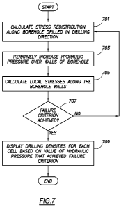
[0078] FIG. 7 shows a flowchart for calculating drilling densities in one
or more
embodiments. By way of an overview, in one or more embodiments, the
calculation of the
critical mud densities (i.e., drilling densities) is performed independently
at each cell. The
calculation is performed by transforming the local acting stress state onto a
new reference
coordinate system that is defined by a prescribed drilling inclination and
azimuth (possibly
from a safest drilling direction cube). The stress redistribution along an
arbitrary borehole is
calculated analytically. Further, the equivalent hydraulic pressure over the
face of the
borehole is iterated until a given failure criterion is achieved.
[0079] The pressure values of the equivalent hydraulic pressure when
failure criterion is
achieved provide the analytical limits to define the onset of failure. In one
or more
embodiments, the pressure values are calculated both for shear and tensile
mechanisms,
thereby providing a lower and upper drilling fluid density limits,
respectively, in one or more
embodiments.
1063250_2 22
CA 02826854 2013-08-07
WO 2012/109352 PCT/US2012/024325
[0080] Turning to FIG. 7, in 701, stress redistribution is calculated along
the borehole
drilled in the drilling direction. Specifically, at this stage, as discussed
above, the drilling
direction of each of the cells in FIG. 6 together defines a path. For the
calculations of FIG. 7,
a borehole is assumed to be drilled that follows the path. Stress
redistribution is calculated
along the assumed borehole. In one or more embodiments, a strain/stress model
is used to
calculate stress redistribution. The strain/stress model may be obtained from
any source. For
example, the strain/stress model may use a finite element method, such as an
industry
standard for advanced stress modeling.
[0081] In 703, the hydraulic pressure over the walls of the borehole is
calculated in one or
more embodiments. Specifically, an assumption is made that the hydraulic
pressure is
increased to a new value. The amount of the increase may be a configurable
parameter of the
oilfield three-dimensional simulator application in one or more embodiments.
[0082] In 705, local stresses along the borehole walls are calculated in
one or more
embodiments. In one or more embodiments, the local stresses may be calculated
using Kirsh
equations. However, the calculations may be performed using any stress
modeling technique,
such as those found in E. Fjaer et al., Petroleum Related Rock Mechanics, (2nd
Ed., Elsevier
B.V., 2008) (1992).
[0083] In 707, a determination is made whether a failure criterion is
achieved. Specifically,
a determination is made whether the amount of local stresses exceeds the
stresses for the
borehole causing failure or warning of a failure of the borehole. In
particular, in one or more
embodiments, the failure criterion may indicate an amount of local stresses
sufficient to
compromise the integrity of the borehole. Alternatively or additionally, the
failure criterion
may indicate an amount of local stresses that is sufficient to cause failure
of the borehole.
The determination may be made by comparing the local stresses with a defined
maximum
stresses for the geologic structures. The maximum stresses may be in the three-
dimensional
model or separate from the three-dimensional model. If the local stresses are
less than the
maximum stresses, then the flow returns to 701. If the local stresses are
greater than
maximum stress than the flow proceeds to 709.
1063250_2 23
CA 02826854 2013-08-07
WO 2012/109352 PCT/US2012/024325
[0084] In 709, the drilling densities are displayed for each cell based on
value of hydraulic
pressure that achieved failure criterion in one or more embodiments. The
drilling densities
may be displayed in the three-dimensional model in one or more embodiments.
Specifically,
the drilling densities may be displayed using numerical values and/or color
coding in the
three-dimensional model. Displaying the drilling densities may be performed,
for example,
by the visualization engine.
[0085] FIG. 8.1-8.4 show examples in accordance with one or more
embodiments of the
three-dimensional modeling. The following examples are for explanatory
purposes only and
not intended to limit the scope of the claims.
[0086] FIG. 8.1 shows an example diagram for minimizing the maximum
tangential stress
(800) around a wellbore as a function of inclination and azimuth.
[0087] FIG. 8.2 shows an example diagram of the safest drilling direction
(818) imposed
over a seismic line. Specifically, in one or more embodiments, the safest
drilling directions
model can be displayed as a discrete vector field. To display the safest
drilling directions
model, the inclination-azimuth combination may be transformed into a unit
vector placed at
the center of the corresponding cell. The transformation allows the user to
intuitively guide
the design of a drilling trajectory, while accounting for the geomechanical
considerations of
the geologic region. In one or more embodiments, the path (820) (i.e.,
trajectory) defined by
the drilling directions starts at starting point (822) and ends at reservoir
(824). In Figure 8.2,
as specified in the legend, the different regions represent different mud
densities in pounds per
gallon. As shown in FIG. 8.2, the mud densities are on a scale that from 0 to
18 in one or
more embodiments.
[0088] FIG. 8.3 shows example diagram for an extraction of low mud window
(830) (i.e.,
the difference between minimum and maximum drilling densities) in the three-
dimensional
model. Specifically, FIG. 8.3 shows extracted zones of low mud window to
exhibit volumes
within the three-dimensional model of higher risk zones. The arrows in FIG.
8.3 depict a
direction of principal stresses in the model.
1063250_2 24
CA 02826854 2015-04-14
54866-9
[0089] FIG. 8.4 shows an example diagram for iterating along the mud
weights (838) to
achieve failure criterion along the borehole wall. Specifically, stress
redistribution along an
arbitrary borehole is calculated analytically and the equivalent hydraulic
pressure over the
face of the borehole is iterated until the given failure criterion is
achieved. In FIG. 8.4, the
failure criterion is achieved at point (840).
[0090] While the invention has been described with respect to a limited
number of
embodiments, those skilled in the art, having benefit of this disclosure, will
appreciate that
other embodiments can be devised which do not depart from the scope of the
invention as
disclosed herein. Accordingly, the scope of the invention should be limited
only by the
attached claims.