Note: Descriptions are shown in the official language in which they were submitted.
CA 02834189 2013-10-24
1
Calibration method for a device having a scan function
The invention relates to a field calibration method for a device
having a scan function for spatially surveying objects, and to a
device having a scan function.
3D scanning is a very effective technology for producing
millions of spatial measurement points of objects within minutes
or seconds. Increasingly, terrestrial 3D scanners are also used
for classical surveying tasks and projects. At the moment,
however, said scanners still have a few deficiencies or
disadvantages, such as for example a field workflow that is
atypical for geodetic surveying, insufficient measurement
accuracy or the need for subsequent data processing in the
office to prepare the desired measurement results.
Established manufacturers of laser scanners are currently
working on matching the workflow management of 3D scanners to
the needs of classical surveying. A first step here is to reduce
the size of the scanner apparatuses and to improve their
robustness so as to allow their field use in rough environments
such as for example on construction sites. Portability and a
flexible and quick setup of the measurement devices are
essential requirements in surveying applications. Examples of
such scanner apparatuses are the TRIMBLE GX 3D, Faro Photon 120
or ScanStation C10 by Leica Geosystems, such as is described for
example in DE 20 2006 005643 U1 or US 2009/147319.
For classical surveying tasks such as for example recording
buildings or civil engineering structures, the measurement
accuracy of such prior art scanners is frequently too low. In
particular in the case of steel structures, high point accuracy
CA 02834189 2013-10-24
2
is unavoidable since the structural elements used in this case
usually require narrow measurement tolerances. Attempts have
therefore been made to achieve higher measurement accuracy with
each development generation of such scanner apparatuses, not
least to be in a position to cover new markets and further
surveying tasks.
Examples of recent scanner applications are:
- monitoring existing buildings with respect to changes in
shape, subsidence, tilting etc;
- monitoring the construction progress on construction sites
and monitoring the dimensional accuracy of the work that has
been carried out;
- support during setup and alignment of various components on
construction sites, such as for example columns, pipelines,
openings, windows, doors, ready-mixed concrete parts etc.;
- inventories of existing buildings for map representation or
3D modeling, for example when planning reconstructions or
extensions;
- forensic/criminal-technical applications, for example for
digitally reconstructing events at incidence scenes or accident
sites;
- classical surveying tasks such as land surveys, spatial
planning, marking of buildings, checking zoning regulations
etc.;
- historical restoration.
CA 02834189 2013-10-24
3
In terms of basic construction, such scanners are configured to
acquire, using a distance measuring unit, usually an electro-
optical and laser-based distance measuring unit, a distance
from a measurement point. A direction-deflection unit, which is
likewise present, is configured here such that the measurement
beam from the distance measuring unit is deflected in at least
two spatial directions, as a result of which a spatial
measurement region can be captured. The deflection unit can be
realized in the form of a moving mirror or alternatively also
by other elements suitable for controlled angular deflection of
optical radiation, such as for example rotatable prisms,
movable light guides, deformable optical components etc.
Measurement is usually carried out by determining distance and
angles, that is to say in spherical coordinates, which can also
be transformed into Cartesian coordinates for representation
and further processing purposes. The distance measuring unit
can be designed for example according to the principles of
time-of-flight (TOF) measurement, phase measurement, wave form
digitizer (WFD) measurement or interferometric measurement. For
quick and accurate scanners, in particular the measurement time
must be short while simultaneously achieving high measurement
accuracy, for example a distance accuracy in the millimeter
range or below for measurement times of individual points in
the range of microseconds or milliseconds.
The distance measuring units used in scanners frequently have
internal reference sections, such that calibration of the
distance measurement, in particular of the distance offset, can
be carried out thereby and thus a high degree of accuracy of
the distance measurement is attainable. The slope error or
, scaling error in today's distance measuring units is often much
less than 1 ppm, and recalibration is therefore rarely
necessary. However, the distance offset can change over time,
field calibrations therefor are widely known today. In older
devices, the point accuracy of scanners, as the maximum 3D
CA 02834189 2013-10-24
4
distance deviation and thus error of the measured point in
space, was often limited by the measurement accuracy of the
distance measuring unit. More accurate distance measurements
required correspondingly longer measurement times, as a result
of which an increase in distance measurement accuracies was
accompanied by a reduction in the measurement or scanning
speed, as surveyed spatial points per unit time. With advances
in the field of electro-optical distance measurement, fast to
ultrafast laser distance measuring units that still have high
distance measurement accuracy are available today.
The critical link in the overall system with respect to point
accuracy has thus shifted from distance measurement accuracy to
the area of angle measurement accuracy. In order to be able to
meet the increased accuracy requirements, the long-term
stability of the opto-mechanical system is also of increasing
importance.
Commercial scanners with high accuracy nowadays achieve a point
accuracy in the range of 5 to 20 mm for measurement distances
below 200 m. For distances of up to 50 m, the achievable point
accuracy is 2 to 6 mm, and for measuring distances of less than
m, a point accuracy of approximately 1 to 4 mm is certainly
achievable. With respect to the direction accuracy or angle
25 measurement accuracy, a section of 5 mm at a distance of 50 m
for example corresponds to an angle measurement accuracy of 20"
(angular seconds) or approximately 100 prad, which in the prior
art already represents a high angle measurement accuracy.
Scanners of the highest precision that are currently available
on the market can certainly be categorized into a product class
having an accuracy of between 8" and 12", however, such scanner
apparatuses with a specified direction accuracy or angle
measurement accuracy of better than 20", and in particular of
better than 12", are confronted with new problems which in less
CA 02834189 2013-10-24
precise scanners are of no or merely subordinate importance. A
3D scanner having the high specified angle measurement accuracy
mentioned above requires careful handling, use and care in
order to retain said accuracy. In particular in mobile,
5 portable apparatuses for field use, influences from the
environment such as for example direct solar irradiation,
bumps, impacts etc. must be expected, which can result in
mechanical misadjustment and an accompanying reduced
measurement accuracy. Such high-precision scanners are
therefore suitable for use in a laboratory, but not in the
field.
Known scanners also do not allow the end user to check the
accuracy of the instrument in the field without undue effort,
as is the custom with classical measurement devices. Any
accuracy guarantee can at best be provided by the manufacturer,
but this requires time-intensive and cost-intensive short check
intervals and recalibration in the factory. The axis error
values (for example in the form of angles and distances
(offsets)) that are ascertained by the manufacturer, at an
institute which is correspondingly equipped therefor, or at a
national testing laboratory are usually directly input and
stored in the instrument software.
In order to also introduce scanning measurement systems having
a polar measurement principle, such as a terrestrial laser
scanner, increasingly into geodetic practice, approaches have
also been developed to examine calibration and checking of the
measurement accuracy for these devices.
However, the error determination is here generally based on a
construction which is analogous to the tachymetric measurement
principle. However, scanners have an entirely different
construction, which is why such an approach does not apply. In
CA 02834189 2013-10-24
6
particular the error influences of the laser axis can differ
significantly from those of a classical target axis.
A known calibration method for example uses a set of planes
arranged in space, which are scanned several times in different
instrument setups. On the basis of the known algorithms of
combining points of view, the calibration method determines the
accuracy of the system or calibration parameters from the
identical object planes by utilizing one or more adjustment
calculations.
To register scanned point clouds, as a combination of
measurement data from individual scan cycles in different
scanner setups, a transformation (for example Helmert
transformation) over identical points can be carried out. The
identical points are derived from the data of the scanned
target marks, wherein, however, commercial target marks or
targets can often not be surveyed by a scanner with the
accuracy that is required herefor. An accuracy determination in
such a setup, in which subsequently the measurement is also
carried out, would also be preferable to the frequent position
changes of this method. The entire calibration process is
relatively complex, since for a sufficiently accurate
determination of the instrument errors, for example more than
ten planes in at least three setups are required, which is
impractical for a routine field use in geodesy.
Another known method uses a known highly accurate reference
point field (tie points), which is fixed for example in a hall
on the walls and on the ceiling in the form of a large number
of reflective target marks. The coordinates of these reflective
target marks are initially calibrated exactly using a highly
precise coordinate measuring machine such as a theodolite, and
subsequently these predetermined coordinates which are known
exactly are correlated with the scanner data by a mathematical
CA 02834189 2013-10-24
7
calibration model. Such a procedure is too complex for general
field use and therefore not practicable. Another disadvantage
is the additional falsification of the angle calibration on
account of latency times in the synchronization between angle
and distance measurement. The ascertained spatial coordinates
of reference objects or reference points are falsified on
account of the dynamic scanning process, in particular in
scanners with a fast rotation axis of typically 100 Hz. A
synchronization delay of for example 100 ns in a scanner that
rotates at 100 Hz already produces an object offset of 13
angular seconds which is tangential to the scanning movement.
This error is reflected in the above method as an index error
in the determination of the calibration parameters.
Also known is the method of reversal measurement commonly used
in electronic theodolites in geodesy, which takes place as
follows: the sighting device is used to measure exactly
centrally and accurately to the second, that is to say with an
accuracy in the range of a few angular seconds or less, one or
more target marks in two telescope faces. The axis-relevant
system parameters can be determined or the system accuracy can
be verified on the basis of the measurement angles associated
with the exact measurements. The system is here used in a
direction of (X, Y) gon in the initial state and at
approximately (X+200, 400-Y) gon in a rotating state, wherein
all elements that contain errors and determine direction, such
as the vertical axis, the trunnion axis and in particular the
target axis of the sighting device, are rotated.
According to this principle, it is possible to determine a
large number of errors, which in theodolites or analogously
constructed instruments can substantially be represented by the
following calibration parameters:
CA 02834189 2013-10-24
8
1 ,q: index error of the 2-axis tilt sensor, or of the vertical
axis tilt
i: index error (angular offset) of the vertical angle sensor
C: collimation error of the collimation line
k: trunnion axis tilt.
A model having such parameterization or analogous
parameterization will also be referred to as theodolite model
below.
By way of example, the index and collimation errors are
determined using a two-face measurement with a preferably
horizontal collimation line, since with this arrangement the
two types of error can largely be separated from the influences
of the other parameters.
Although the laser scanner also makes it possible in principle
to scan an object as described above in two alignments of the
sensor head, the influences of the angle errors and the
distances (offsets) of the scanner axes using point clouds from
the first and second alignments cannot be ascertained and
eliminated in the same form. For one, this is because exact
point association is not always provided on account of the
rastered surface-type measurement, especially with point
densities in the raster of 5 mm and coarser. Another reason is
because the calibration models have been entirely taken up by
the theodolite or tachymeter model, and the latter do not
correctly describe the measurement system of a scanner. As a
result, non-real or even impermissible instrument parameters
are determined and, in addition, their influences on the
coordinate deviations are incorrectly modeled, which per se
cannot lead to the intended improvements.
CA 02834189 2013-10-24
9
It is known in the prior art for example to record, for the
reversal measurement in scanners, at least six white marking
spheres made of wood as test objects in one scanning process in
two alignments. The measurement values are here the coordinates
of the captured portions of the sphere surfaces, from which the
coordinates of the sphere center points are calculated and
subsequently the axis errors are ascertained by modeling and
adjustment calculation. The determination of the coordinates of
sphere center points using scanners, however, largely contains
gross errors. For example, at best systematic errors of
approximately 3 mm can be achieved using the known three-
dimensional test objects at a distance of 50 m, wherein the
standard deviation is approximately of the same order of
magnitude. Precise calibration is therefore not possible, in
particular in conjunction with a device model as a basis which
does not correctly describe the axis system of the scanner. The
above-mentioned accuracies are simply not sufficient to
calibrate errors of the axis system of a scanner.
For highly precise error determination, even in the above-
mentioned reference point field that is known with a high level
of accuracy, the residuals or the noise components are too
great for an adjustment calculation of the scanner data with
the reference data. In laser scanners, the above-mentioned
classical parameter set of the reversal measurement is also no
longer applicable in this form, and there is also no sighting
device for a measurement that is accurate to the second.
Although the laser beam can at first glance be considered
representative of the collimation line, it has entirely
different properties with respect to the directional
invariants. This new type of dependence or parameterization of
the collimation line has up until now not been taken into
consideration in this form in surveying, or it has either not
CA 02834189 2013-10-24
been known at all up until now or at least its influence on the
calibration was not known in this form.
As already mentioned, a corresponding robustness of the entire
5 3D scanner apparatus is also necessary to ensure the required
angle measurement accuracies and to obtain highly accurate and
reproducible measurement results. For this reason, the
components for laser-beam guidance, in particular static or
rotating deflection units, must have a high stiffness in order
10 to be resistant to environmental influences. On the other hand,
in addition to the aforementioned quick distance measurement,
generic scanner apparatuses must also move the measurement
laser beam with a correspondingly high speed so as to scan
objects within a short period of time. This scan movement can
be realized for example with quickly oscillating or rotating
mirrors, for example at a high rotational speed or frequency of
more than 200 rotations per second. For reasons of dynamics, it
is necessary even at medium speeds, below the deflection
frequency of 200 Hz mentioned by way of example, for the
dimensions of the moving part to be kept as small as possible,
which, however, is inconsistent with the requirement of high
stiffness.
Users of classical surveying instruments such as theodolites or
tachymeters are accustomed to being able to check the accuracy
of their measurement system any time and without undue effort,
be it for example in a space with known reference marks or in
the field by measuring suitable targets in two faces. The known
scanners do not provide this possibility, and the user will
practically have no option for accurately determining or
verifying the measurement accuracy of the device or of
calibrating the device.
CA 02834189 2013-10-24
11
It is therefore desirable to provide a reliable and precise
device having a scan function, including for field use.
It is desirable to provide a precise device having a scan
function, which enables the user to check or correct the system
accuracy and/or the calibration of the device in a simple, but
exact manner.
It is also desirable to provide the user with a check and
measurement process for a device having a scan function, so that
the user in the field can himself check the measurement accuracy
and/or newly determine the calibration parameters in situ, if
appropriate.
Disclosed herein is a method for ascertaining the accuracy
and/or calibration of a device having a scan function, in
particular with a device or error model that is matched
specifically to such scanners, with the method also being
suitable especially for simple execution in the field.
It is also disclosed that said method renders the accuracy
determination and/or calibration of a device having a scan
function ascertainable with a single device set up.
Also disclosed is a method for accuracy determination and/or
calibration of a device having a scan function, which is
suitable in the field for non-surveyed target objects, that is
to say target objects without spatial coordinates obtained using
a total station or other surveying devices.
The disclosed method may be carried out in a manner that is at
least partially automated, in particular with corresponding user
guidance for automatic or semiautomatic execution of an accuracy
check and/or calibration process.
As already shown, the user of classical surveying instruments
such as theodolites can check and if necessary calibrate the
CA 02834189 2013-10-24
12
angle measurement accuracy of the instrument using simple
measurement methods. From the viewpoint of a surveyor, scanners
should also provide a possibility for field calibration by the
user himself, similar to that which is known from theodolites or
total stations. Of primary importance here for the surveyor for
the current measurements in the current stationing is not a
theoretical device accuracy under laboratory conditions but the
current system accuracy.
The calibration method according to the invention, which will be
explained in detail below, relates to a device having a scan
function, in particular to a device measuring in polar
coordinates, for example a 3D scanner, having an electro-optical
distance measuring device with a laser axis as the target axis,
a motorized optical deflection unit, which deflects the target
axis by a variable deflection angle with respect to the distance
measuring device, in particular wherein the target axis (3) is
deflected by a mirror which is movable with respect to the
distance measurement device, and at least one angle measurement
device for determining an angular position of the deflection
unit.
The calibration method contains the following steps:
CA 02834189 2013-10-24
13
= a first survey of angle coordinates of a target mark in a
first angular position of the deflection unit as the first face
and
= a second survey of angle coordinates of the target mark in
a second angular position of the deflection unit as the second
face,
wherein the first face and second face differ, in particular
wherein the first face is rotated relative to the second face
in two axes such that the target axis in both faces points at
least approximately in the same spatial direction.
The two axes in this case correspond to the axes of the
deflection unit, which may be malpositioned as compared to a
theoretical axis system on which the surveying is based. One of
the axes for example is a vertical axis which is rotated by
approximately 200 gon, and the other axis is a trunnion axis
which is rotated about 400 gon minus its angular position with
respect to the vertical axis in the first face.
Here, the first and second surveys of the target mark are
carried out using images, which with a camera with a field of
view, the optical axis of which is deflected by the deflection
unit with respect to the camera, and calibration parameters are
determined on the basis of the angular positions and the angle
coordinates in the first and second faces.
Here, the survey is carried out using images with a resolution
of the image coordinates of the target mark with a high
(angular) resolution of the field of view, in particular with a
resolution of the images of less than 3 angular seconds,
preferably of less than 1 angular seconds, which can be
achieved by way of subpixel interpolation of the camera images.
CA 02834189 2013-10-24
14
The basis used here is in particular a mathematical device
model, which represents the mechanical setup and the beam
guidance of the device having a scan function, specifically a
device model which (in contrast to the theodolite model) has
collimation and/or index errors of the target axis which are
dependent on the elevation of the target axis.
Subsequently, the accuracy, residuals and/or statistical
characteristics of the system accuracy can be ascertained on
the basis of the calibration. The calibration, in the form of
calibration parameters, can be used to correct measurement
values which are ascertained subsequently, in particular point
clouds. Calibration parameters can be determined on the basis
of the angular positions of the at least one axis, in
particular however of both axes, and the angular coordinates in
the first and second faces.
Initially, as a partial aspect of the present invention, and as
a basis for the further explanations, a mathematical device
model and the calibration-relevant parameters of a laser
optical scanner are identified. To this end, the aspects of an
exemplary embodiment of a scanner explained below are
discussed. The general considerations with respect to beam
guidance made here can be applied analogously by a person
skilled in the art also to alternative embodiments.
On account of the aforementioned high rotational speeds of the
scanner rotational head, in scanners the laser source is
usually arranged in the support. The direct coupling of the
target axis to the trunnion axis, which can be found in the
theodolite model, is thus no longer present, since the laser
source is not moved directly together with the trunnion axis.
As a result, in a two-face measurement, the collimation line is
not rotated as is the case for example in the case of a
theodolite. As a result, particular errors cannot be identified
CA 02834189 2013-10-24
correspondingly uniquely in a scanner with a classical two-face
measurement either, as is carried out in theodolites.
One possible parameter set of calibration parameters of an
5 exemplary embodiment of a scanner, in particular with the
above-described laser arrangement, is for example as follows:
1 ,q: index error of the 2-axis tilt sensor or of the vertical
axis tilt;
i: index error (angular offset) of the vertical angle sensor;
rc, ri: angle error of the laser source with respect to the
rotation or trunnion axis;
pci: angle error of the rotational mirror with respect to the
rotation or trunnion axis;
k: tilt of the rotation or trunnion axis with respect to the
vertical axis.
If the distance and/or the tilt angle of the device setup are
also included as further parameters, the problem of a system
calibration for the entire surveying system arises. In said
system calibration, axis, setup and distance measurement
accuracy are checked in one method and calibrated if
appropriate, if the latter do not correspond to the
specifications or requirements.
For the sake of simplicity, primarily the angle errors of the
axes will be discussed in detail below. In the exemplary
embodiments, the axis distances (offsets) are not explicitly
taken into account, but without excluding the general case, in
which said axis distances and further calibration parameters
are also determined according to the invention. By way of
CA 02834189 2013-10-24
16
example, the axis offsets can be ascertained on the basis of an
angle error determination at a number of distances. A person
skilled in the art of error determination in surveying devices
can also determine in an analogous or similar manner the
further system calibration parameters of the total system
according to the present invention and combine them with
further methods that are known and routine measures in geodesy.
A point cloud generated subsequently in object recordings can
then achieve the specified or required high measurement
accuracy with certainty. The device setup can remain unchanged
during the calibration and measurement.
Operation of the check and/or calibration process can be made
available via a local user interface directly in situ on the
scanner. The user interface can alternatively also be realized
by a remote user interface, which is connected using cables or
radio signals, or by software on a PC, laptop, tablet PC,
smartphone etc. A partial aspect of the present invention is in
particular also the provision of a calibration program, which
instructs the user using a user interface to ascertain the
systematic axis and offset errors of the scanner using scanner
data of scanned and identifiable objects or target marks,
preferably in two alignments of the sensor head.
In scanners, the lack of a sighting device for measurement that
is accurate to the second makes it difficult to carry out the
calibration method known from theodolites. Surveyors are
sufficiently familiar with the loss of precision of the
calibration parameters owing to inaccurate observations and
measurements on account of the variance-covariance error
propagation. However, as explained above, in scanners with
modern distance measuring units it is in particular the angle
measurement which becomes a critical component with respect to
the point accuracy that can be achieved. The angle measurement
CA 02834189 2013-10-24
17
accuracy on target marks in scanners is usually no more
accurate than 10 arcsec, as a result of which a calibration
which is produced using such observations cannot achieve the
precision required in geodesy. Not only is there a lack of
target marks which are suitable and recommended therefor
(rhombic patterns, spheres,
but also of
corresponding application programs and user interfaces to be
able to carry out error determination and error assignment in
scanners to the required precision.
High angle precision of polar measurements to target marks or
target objects, however, can be achieved by a measurement using
a camera. Modern scanners are often equipped with an integrated
camera, with which image information that is also associated
with the point clouds of the surveyed spatial points can be
recorded. Known are in particular panoramic images, also
referred to as fulldome recordings. Here, the camera usually
has a surface-type image sensor and at least one objective
having focus and/or zoom function.
The present invention utilizes such a camera integrated in the
scanner, which camera is mounted in a position which is fixed
with respect to the axis system and is accurately defined. By
way of example, the camera is mounted in the continuation of
the trunnion axis in the support. The laser of the distance
measuring unit can be placed on the same side, or alternatively
on the opposite side of the trunnion axis. The camera is
preferably arranged such that the scanner or laser target axis
is located in the field of view (or field of vision) thereof,
as an angular region capturable by the camera. Cameras which
are arranged in this manner are also referred to as boresight
cameras. In an axis system without errors, the ideal scanner
target axis would lie in the normal plane with respect to the
trunnion axis, and the three axes would intersect together with
the vertical axis in a point, which intersection point usually
CA 02834189 2013-10-24
18
also corresponds to the origin of the measured polar
coordinates. The principle according to the invention is
alternatively also possible with a camera which has a parallax
with respect to the scanner target axis, although for the sake
of simplicity, and without being limiting, the explanations
below will refer to a boresight camera.
In the embodiments of integrated cameras, two aspects in
particular are worthy of note. Firstly, for a correspondingly
accurate calibration, the attainable angular resolution and
thus also angle measurement accuracy of the camera must be in
the angular second range. Certainly the camera must be capable
of resolving angles which are smaller than that angle accuracy
which is to be attained by the calibration. In addition, the
field of vision of the camera must not be too small. Typical
fields of vision are at least approximately 15 or more.
Before the actual check begins, the 3D scanner should be
leveled as well as possible, as a result of which it is also
possible to carry out a check of the tilt sensor, for example
by the latter likewise rotating about the vertical axis and the
tilt being determined in at least two known angular positions.
In any case it must be ensured that the scanner during the
calibration and measurement has a stable position, cannot sink
and, if possible, is protected against direct sunshine.
In addition to the already explained stable setup of the
scanner as the surveying instrument, a target object is
required that is just as stable. For example, an A4 target
plate is arranged in a position that is fixed in particular
relative to the scanner, for example at a distance of 15 m to
30 m, and is as perpendicular to the target axis or laser axis
as possible. Fixing of the target plate as the target mark
should here ensure an accuracy of the alignment or center point
determination of 0.2 mm or better. During the calibration
CA 02834189 2013-10-24
19
process, the setup of the instrument and of the target plate
must not change.
The target plate is here configured such that it is possible to
determine the position of an optical feature by way of the
camera, for example a center point determination of the target
plate, with a precision of typically 1 to 5 angular seconds.
The definition of the target plate can be present for example
as a PDF file. Its physical realization can then be produced
using a commercial printer. Alternatively, other target objects
with two-dimensional or three-dimensional shapes and great
brightness contrasts can also be used. In any case, the scanner
with the camera requires unobstructed view to the target plate
as the target object.
An exemplary check and calibration process will be illustrated
below, which process ensures a sufficiently exact angular
determination so as to verify the system accuracy. This process
can also be carried out in the field by a user. The scanner has
the capability of being able to carry out a measurement
operation in each case in two measurement faces, as is known
from the previously described two-face method.
The check process using a scanner according to the invention
having a camera can in this case comprise the following steps
which will be explained in detail by way of example. The
specific combination, sequence and practical configuration of
the steps can depend on the parameters to be determined, on the
locational situation and on the required accuracies. The check
and calibration process should preferably be attained using a
single scanner setup.
In a first step, a setup of the scanner should be selected. A
fixed setup over solid ground is essential in this case. The
scanner can in this case be set up at a recommended distance
CA 02834189 2013-10-24
from the target marks or target objects provided, if the latter
are already known in advance. Alternatively, the scanner
position can also be chosen freely, and the target plates can
be correspondingly positioned thereafter, as described in step
5 2. By setting up in that position from which a subsequent
measurement is also to be carried out, it is also possible to
avoid any misalignments owing to a change in stationing of the
scanner between calibration and measurement.
10 In a second step, the user defines the calibration parameters
to be checked, for example all of the parameters or a selective
choice thereof. In addition, the user can define a prespecified
accuracy to be achieved either for the total system or
separately for each parameter.
The scanner according to the invention calculates and displays
a proposal for the elevation of the "scan field" with the
extension of the elevation sector above or below the horizon,
in which the target objects, target plates or target symbols
are advantageously to be applied. Furthermore, the instrument,
or specifically a digital calculator integrated therein or
integrated in an operating device having corresponding
software, calculates a recommended, optimum distance or
distance range from the target objects. Typical check distances
are for example 10 m to 50 m between target plates and scanner.
By way of example, it may be advantageous to position at least
one target plate as close as possible to the horizon at 100 gon
and as perpendicular as possible with respect to the target
axis, as is also done in theodolite check methods to determine
the target axis error.
If, for example, at least some of the calibration targets are
prespecified, if the possible target plate positions are
restricted on account of the surroundings, or if the
experienced surveyor can already estimate advantageous target
CA 02834189 2013-10-24
21
positions, it is also possible to at least roughly provide the
device with known target positions, or to let the scanner
autonomously identify the target plates in an automated search
run. It is necessary to ensure a fixed, firm setup during the
calibration process even when using target plates.
To check the number n of previously selected parameters to be
checked, generally (without taking into consideration condition
equations) at least n measured coordinates of appropriately
configured target marks should be recorded. In this case,
appropriately configured or advantageously setup means
specifically that the target plates be mounted at least
approximately at the positions proposed by the device or at
equivalent positions, and that the target plates can be
observed in two faces.
The user may also be requested by the user interface to place
for example 1 to 10 target marks in the corresponding elevation
sector, or to determine correspondingly appropriate, natural
target marks in these areas. The user may also receive a
recommendation to possibly readjust target plate positions,
which is recommended for optimizing the determinability of the
calibration parameters.
If the scanner has a visible marking laser, the scanner can use
it to mark for example a proposed target plate position or a
corresponding position region and to monitor, for example using
the distance measuring unit, and to signal optically,
acoustically or using a remote user interface to the user that
a recommended distance range has been reached.
It may for example be a selection criterion of the proposed
target position that in this case some of the target points are
placed if possible at various sight angles, for example with
vertical angles at the upper and at the lower edge of the
CA 02834189 2013-10-24
22
elevation sector and also close to the horizon (100 gon) for
the measurement. Responsible for the user guidance is
specifically a software program, which was developed using a
sensitivity analysis of the functional model of the laser
scanner.
With an optimum calibration field of appropriately configured
target plates or natural targets, the required accuracy in the
determination of the calibration parameters can be ensured.
However, the method can also be carried out in the presence of
necessary deviations of the proposed target mark positions due
to the environment, but if appropriate with reduced accuracy or
reliability of the calibration process as compared to an
optimum arrangement, which the user guidance of the user
interface can also appropriately point out.
Subsequently, a manual, semiautomatic or fully automated
calibration of the directions to the target points is carried
out, wherein the scanner device recognizes and/or identifies
the targets and can subsequently measure them automatically in
a targeted manner for accurate surveying. The scanner can in
this case also check whether the target objects are in the
required distance range and the recommended elevation sector.
At the same time, it is also possible for the orientation of
the target plates with respect to the target axis to be roughly
checked. In a fully automated operation, the camera supports
the search for target points. The camera also ascertains the
particular brightness contrast of the target mark and checks
whether it suffices for precise angle determination.
Subsequently, optional calibration of the camera with respect
to the current axis system can be carried out, wherein this
step can be carried out not each time the method is carried
out, but for example only in the context of a works calibration
or at relatively large check intervals. In a large number of
CA 02834189 2013-10-24
23
generic scanners, a high stability of the imaging optics and
the arrangement of camera with respect to the vertical and
trunnion axis can be assumed. This optional step for camera
calibration can also be carried out if the tilt of the trunnion
axis with respect to the vertical axis is still undetermined.
Optional determination of the camera zero point can be carried
out for example with a zenith targeting operation. Such a
zenith targeting operation may be carried out as follows:
- Applying one or more target plates in a row in the zenith
(for example mounting to the ceiling).
- Determining at V=0 gon in face 1 and 2 the target plate with
the camera.
- Moving the target axis in the V direction until the target
plate is located at the edge of the field of vision of the
camera.
- Determining the V angle using the angle encoder at this
elevation direction and capturing the target plate in face 1
and face 2 using the camera.
- Moving the target axis in a further V direction and
determining again in this third elevation direction the V angle
using the angle encoder and capturing the target plate in face
1 and face 2 using the camera.
All relevant calibration parameters including the camera zero
point can be determined from the measurement data and camera
images ascertained in the process. The camera zero point in
this case can be defined in any direction having direction
parameters (rc,ri)=(0,0), as a result of which a check and/or
new calibration of the laser target axis is simplified. If the
camera zero point is known in this manner, a further
measurement can be used to determine directly the laser beam
direction using the parameters (rc, ri) in the coordinate
system of the camera. The optional check and calibration of
CA 02834189 2013-10-24
24
further internal camera parameters such as focal length and so
on is carried out using a matrix-type scanning operation over a
target plate that is placed approximately perpendicular to the
target axis, preferably at approximately V=100 gon.
In a first substep, the device determines a required
measurement point density of the subsequent matrix scan from
the required prespecified accuracy and the contrast of the
image of the target plate. The target axis and the field of
view of the camera of the scanner subsequently moves in a
raster-type manner over the target plate, during which the
camera records in each case images of the target plate, wherein
the angle sensors of the deflection unit capture the angular
positions of the axes assigned to the images, for example with
Hz as the horizontal angle of the vertical axis and V as the
vertical angle of the trunnion axis. The result is a set of
images of the target plate with the associated axis positions,
which images are recorded in the 2D raster of the matrix scan
and are displaced according to the matrix raster. Using image
processing software, the positions of a visual feature of the
target plate, for example its center point, in camera
coordinates, that is to say in the image plane, are calculated.
On this basis, the calibration parameters such as rotation of
the camera with respect to the axis system and/or scaling of
the camera pixels with respect to the angle sensors can be
determined. Deviations from the orthogonality of the
transformation matrix thus determined between pixel coordinates
and axis system give a first indication of any angle errors of
the trunnion axis.
In a further measurement, the laser beam direction with respect
to the coordinate system of the camera can be determined. This
process depends greatly on the specific embodiment of the
scanner's internal setup. In the simplest case, the laser spot
is projected onto the same target plate, the position of which
CA 02834189 2013-10-24
is the captured by the camera and surveyed in the image of the
camera. Thereby the laser target direction in the camera
coordinate system is determined.
5 In the next step, the scanner instrument starts the actual data
evaluation to ascertain the instrument accuracy. The camera is
used to photographically record the previbusly set-up targets,
in two faces, using the camera in corresponding two images.
Subsequently, a similarity transformation, in particular in the
10 form of an image rotation and image translation, is carried out
between the images which were recorded in each case in the two
faces. In known target object patterns, this can be carried out
for example using what is known as template matching. Using a
geometric axis model matched to the scanner, it is now possible
15 to calculate the axis error of the scanner from the data of the
similarity transformation of the images recorded under the
various sight angles of the respective target plates. As was
already explained above, the camera image together with the
angle sensors allows this process to be carried out with an
20 angular resolution in the angular second range.
Alternatively, the target directions and rotations ascertained
using the camera can also be evaluated using a regression
analysis. The observations of a target plate in face 1 and face
25 2 are correlated with the model of the spatial scanner
coordinate system. Using adjustment calculation, for example
according to the Gauss-Markov or more generally according to
the Gauss-Helmert model, estimated values for the axis
parameters to be determined are ascertained therefrom. At the
same time, improvements or residuals are present in this case
as the result. The residuals provide information on the point
measurement accuracy at the target plates and thus on the
currently achieved angle measurement accuracy of the scanner
instrument.
CA 02834189 2013-10-24
26
A covariance matrix of the estimated parameters derived from
what is known as the cofactor matrix of the calibration model
can be used as a measure of the statistical measurement
accuracy of the instrument to be checked. The differences
between new and old parameters provide information on
systematic measurement deviations and the general scanner
system stability.
For example, the scanner instrument displays on a display of
the operating unit the old and the new ascertained values of
the selected calibration parameters. To check plausibility,
additionally also the confidence intervals for the old and the
new parameters can be displayed or validated in the device.
If the residuals or the new estimated parameters are within the
required or specified accuracy interval, the user can store the
new calibration parameters and terminate the check process. The
new calibration parameters can then be taken into account when
determining the measurement values. However, if the angle
measurement accuracy after the above-mentioned steps is
insufficient, the user may proceed as follows.
If for whatever reasons the required and specified accuracy has
not been attained, the user is informed of this.
One reason could be an unfavorable arrangement of the scanner
setup with respect to the target objects. In this case, the
instrument may make a proposal to the user as to how the target
plates for the calibration can be placed more advantageously,
and subsequently repeat the check and calibration process.
Another reason for insufficient accuracy could be associated
with unfavorable light conditions, which may possibly be
alleviated by changing the position of the scanner and/or the
target plates. Alternatively, artificial illumination of the
,
CA 02834189 2013-10-24
27
target plates may also help. In order to be independent of
unfavorable light conditions, the device according to the
invention may also be equipped with a target illuminating
means, for example. Such target illuminating means are known
for example from total stations with automatic, camera-
supported target measurement. A scanner which is thus equipped
can carry out the required measurements independently of the
external illumination situation.
Once the scanner is calibrated, the evaluation unit can correct
the influences of the axis errors and thus produce precise and
highly accurate point clouds of the scanned objects. The system
accuracy or measurement accuracy of the scanner device can thus
be considerably increased.
Generally, it is recommended to check and if appropriate
determine again the accuracy-relevant calibration parameters
before each precision measurement, in particular once the
scanner has been set-up anew.
Specifically, it is recommended for the determination of
instrument errors to be carried out in the following
situations:
- before precision measurements that require high accuracies
and reliability;
- after relatively long transportations, during which the
device may have been exposed to shock, impact or vibrational
stresses;
- after changes in temperature, in particular of more than
20 C;
- after a relatively long storage period of the device.
,
CA 02834189 2013-10-24
28
The method according to the invention and the apparatus
according to the invention will be described below in more
detail purely by way of example with reference to concrete
exemplary embodiments illustrated schematically in the
drawings, and further advantages of the invention will be
touched upon. Specifically:
figure 1 shows the illustration of an exemplary geodetic
workflow during use of a device according to the
invention having a scan function;
figures 2a and 2b show the illustration of the principle of the
two-face measurement with a precise device according
to the invention having a scan function;
figure 3 shows the illustration of a first exemplary embodiment
of a device according to the invention having a scan
function with a boresight camera, accommodated
laterally in the support;
figure 4 shows the illustration of a second exemplary
embodiment of a device according to the invention
having a scan function with a boresight camera which
is superimposed parallel to the laser;
figure 5a shows the illustration of an exemplary embodiment of
a target plate for the check or calibration method
according to the invention;
figure 5b shows the illustration of an exemplary survey of an
optical feature using a camera;
figure 6 shows the illustration of a third exemplary embodiment
of a device according to the invention having a scan
function with 2-dimensional tilt sensor;
figure 7 shows the illustration of a fourth exemplary
embodiment of the precise device according to the
invention having a scan function with an exemplary
target axis error;
CA 02834189 2013-10-24
29
figure 8 shows the illustration of a fifth exemplary embodiment
of a precise device according to the invention having
a scan function with an exemplary collimation-axis
and trunnion-axis tilt error;
figure 9 shows the illustration of an embodiment of a device
according to the invention having a scan function
with an add-on collimator for laser beam detection;
figures 10a, 10b, 10c and 10d show the illustration of
exemplary observations using a boresight camera in
two faces in a device according to the invention
having a scan function;
figure 11 shows a flowchart of the process of an exemplary
check and calibration process;
figure 12 shows a further exemplary embodiment of a calibration
target according to the invention.
Referring to figure 1, a possible geodetic workflow will be
explained below by way of example. In classical surveying
tasks, the measurement instrument such as a theodolite or a
total station, is placed over a known ground point 9001, 9002,
9003.
Frequently, portable instruments, in particular when being set
up, are subject to high shock-type accelerations, for example
when the device is being latched into an adaptor. Even when the
device is positioned in a centering foot, the direction-
relevant elements in the angle sensors, holders or target axis
guides, such as laser mirrors, may minimally change their
position. As a result, the stored calibration values or
calibration models are possibly no longer completely valid, and
subsequently the measurement accuracy, in particular of the
angle measurements of azimuth and elevation, is also no longer
within the specified ranges. In this case, the scanner needs an
- at least partial - recalibration or possibly a complete new
CA 02834189 2013-10-24
calibration in order to be able to achieve the required or
specified measurement accuracy.
The geodetic stationing of the device comprises among other
5 things the vertical positioning of the instrument, input of the
instrument height, an orientation towards North, and
establishment of the setup with at least one backsight point
12. The backsight point 12 can be, for example, a target mark
with a known height over the assigned ground point. Scanners 1
10 for use in geodesy are - in comparison to theodolites -
likewise equipped with a centering adapter for setting up over
a reference point, with height referencing of the trunnion axis
(rotation axis of the mirror) of the scanner, with a tilt
sensor and corresponding user software for operating these and
15 other functions so as to match the measurement processes as far
as possible to the known work processes of classical surveying
using theodolites or total stations.
Once stationing is complete, the measurement instrument 1 is
20 referenced with respect to a spatial or subordinate coordinate
system 14. Using the backsight target 12, the scanner 1 is also
established in the coordinate system 14. If the scanner 1 is
positioned over the point 9001, it can for example also measure
further points 9002, 9003 in order to associate the data items
25 of the multiple scan thus obtained with one another in a
subsequent setup at those further points. Optionally, it is
also possible to measure existing reference targets 10 in the
capturable field of view of the measurement device, with which
the measurements can be referenced with respect to a spatial or
30 superordinate network or coordinate system. Examples shown of
the objects to be surveyed are the buildings 11 and 13, the
road 15, or the terrain 16 with the group of trees.
CA 02834189 2013-10-24
31
Devices according to the invention having a scan function and
the described methods can, however, also be used analogously
inside buildings, mines etc.
The measurement accuracy of the system is here a critical
factor, both when surveying the individual setup points and the
object scanning data itself. High measurement accuracy can
generally only be guaranteed if it is checked or newly
determined and, if appropriate, can also be corrected or
calibrated in situ. An accuracy check and/or calibration
according to the invention is therefore carried out if possible
directly after the stationing, before the establishment in the
coordinate system or other measurements.
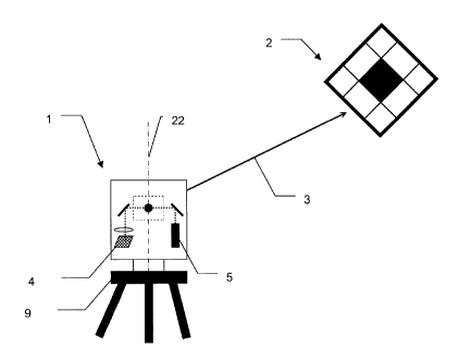
Figures 2a and 2b show by way of example a setup of a scanner 1
with respect to a target plate 2 for the calibration process
according to the invention, which is preferably carried out in
two faces. Figure 2a and figure 2b show a scanner measurement
of a target 2 in each case in a first and second face. The
scanner 1 here has two rotation axes, the axis 22 with the
associated azimuth angle sensor, which is referred to as the
vertical axis, and the axis 23 with the associated elevation or
vertical angle sensor, which is referred to as the trunnion
axis. The line 21 symbolizes the normal with respect to the
axes 22 and 23. In the case of an ideal and error-free setup
and calibration, the vertical angle of the axis 22 corresponds
to 0 gon, and that of the axis normal 21 corresponds to 100
gon. In the case of no errors and exact leveling, the axis 23
lies in the horizontal plane. The arrow 3 represents the target
axis 3 and at the same time the measurement direction of the
distance measuring unit of the instrument 1, which is aimed
onto the exemplary target 2. The angle 34 is the sight angle or
elevation angle and the complementary angle 31 is referred to
as the vertical angle.
CA 02834189 2013-10-24
32
Picture 2b shows, in comparison with picture 2a, the instrument
in the other position of the two-face measurement, in which the
vertical axis 22 (symbolized by the arrow 32) is rotated by
approximately 200 gon and the rotation axis 23 (symbolized by
the arrow 33) is rotated by (400 gon-VI), wherein VI represents
the vertical angle in the first face. In the error-free or
sufficiently calibrated case, as a result, the same target
point is measured, or any errors are determinable on the basis
of the occurring directional deviations.
The determinable types of error in this case are also dependent
on the positioning of the targets 2 with respect to the
coordinate system of the scanner 1. Depending on the accuracy
requirements specified by the user, the instrument 1 can, as
explained above, provide indications relating to the number of
the targets plates 2 to be placed and also propose at what
distances 36 and elevation angles 34 they should be mounted.
Figure 3 shows schematically an example of a scanner 1
according to the invention having a boresight camera 4, which
in this embodiment is accommodated laterally in the support. In
this case, only one last mirror in the beam path is moved about
a fast axis (usually - but not necessarily - the trunnion
axis). The further parts of the scanner are accommodated in a
static part or in a part that is moved or rotated at a
relatively slower speed in a second, slow axis 22. Mostly - but
not necessarily - this is the vertical axis. In such
apparatuses, the camera 4 itself is not rotated about the inner
axis (trunnion axis) which generally rotates very quickly. The
entire distance measuring unit or at least the laser source 5
of the distance measuring unit is usually also arranged outside
the fast, inner axis.
A scanner, as a device measuring in polar coordinates, is, in
particular due to the mirror deflection, no longer constructed
CA 02834189 2013-10-24
33
such that systematic errors, such as for example target and
trunnion axis errors, can be determined using a classical two-
face measurement and averaging, as is the case for example in
tachymeters. Owing to the different construction of
the devices, in particular the beam guidance of the measurement
radiation, this must be taken into account when calibrating.
With respect to the calibration model, this results in
collimation errors and index errors no longer occurring as an
invariant/constant, as is the case in the classical theodolite.
There, the telescope, when changing from face 1 to face 2, is
rotated together with the sight line and laser distance
measuring unit - that is to say the entire telescope - by 200
gon about the target axis, wherein collimation and index errors
occur as constant angle offsets with respect to the normal 21.
In the scanner, on the other hand, the classical calibration
model of the two-face measurement breaks down. The mathematical
model of the scanner differs from that of the tachymetric
measurement principle. The laser 5 or the electro-optical
distance measuring unit 5, with which the laser is to be
associated, is also located, in the example shown, outside the
trunnion axis, that is to say directly on the support. As
indicated schematically, the camera 4 can be realized with a
surface-type image sensor (for example a CCD or CMOS chip) and
an optical unit symbolized by a lens.
By way of example, commercial CCD or CMOS sensors have a size
of 1/1.8 inches, 1/1.5 inches or 1 inch with a pixel number of
6 to 12 megapixels, with the pixel size typically being around
2.5 um. In a practical example of such an integrated camera,
for example, a 2/3-inch CMOS sensor with a resolution of 8
megapixels can be used. The aspect ratio of the active surface
of the CMOS sensor is typically 4:3, as a result of which the
pixel number is 3264 pixels x 2448 pixels. Such a sensor, in
combination with an objective with a corresponding focal
CA 02834189 2013-10-24
34
length, would both meet the aforementioned field of view
requirements and enable the required angle measurement accuracy
of approximately 1 arcsec. Typically, pixel interpolations of
1/50 pixels can be achieved.
The optical unit can, depending on the requirements, be
configured as a fixed-focus or a focusable optical unit,
wherein the latter can be focused for example using the
measured distance information of the distance measuring unit.
In the case of a continuously variable or stepped focus and/or
zoom function, it should be ensured in particular that,
according to the present invention, the current zoom factor and
target line process errors are accordingly taken into
consideration during the calibration and measurement.
The beam paths of laser and camera are superimposed in the
embodiment of figure 3 for example into the fast inner axis
using mirrors. This constellation, which deviates from that of
a classical theodolite, should be taken into consideration in
the mathematical calibration model and in particular in the
configuration of the two-face measurement using a scanner.
Furthermore shown are the setup on a fixedly mounted stand 9
and an example of a target plate 2 having target markings with
a target axis 3 that is aimed onto the latter, which in the
scanner 1 is determined by the direction of the laser beam for
distance measurement.
Figure 4 shows a further customary embodiment for the beam
deflection in a scanner, consisting of a rotation head 7, which
is rotatable about the fast axis 23 (trunnion axis) and a
tilted, reflective surface 29. Superposed into the beam path in
parallel with the measurement beam emitted by the distance
measurement module using laser 5 is the optical axis of the
field of view of a boresight camera 4 (illustrated
symbolically) using a - preferably dichroic -beam splitter 6.
CA 02834189 2013-10-24
The optical axis of the camera can alternatively also be
superposed using a hollow shaft from the opposite axis side, as
a result of which the field of view of the camera with respect
to that of the laser is diametral. For the process of the
5 accuracy determination and calibration according to the
invention, this is, if it is accordingly taken into
consideration, not relevant. Both configurations of beam
deflection and also further alternative embodiments of beam
guidances are compatible with the present invention.
Figure 5a shows an example of a graphical configuration of a
target marking (41, 43, 44) suitable according to the present
invention as a target plate 2, which is used to explain a few
features of such a target mark. In addition to such specific
targets plates 2, however, natural targets, which to a
corresponding degree satisfy the described features, can
certainly also be used. However, to achieve the highest degrees
of accuracy, it is recommended to use targets plates 2 which
were designed specifically with these features in mind.
The exemplary target markings (41, 43, 44) have a geometrically
indicated symmetry point or marking point 41. The target object
having markings can be configured as a planar target plate 2 or
as a spatially structured target object 2. Use of three-
dimensional target objects, however, is not absolutely
necessary according to the present invention.
The previously mentioned marking 41 is intended to be optimized
primarily for the camera, but also for the laser, that is to
say in addition to good visibility on the camera image, it is
also intended for the laser beam to be reflected back of the
distance measuring unit. By way of example, a white zone 41 or
a zone 41 having reflective film is located in the center of
the target plate 2 in order to uniformly image the measurement
laser of the scanner over the entire beam cross section and
CA 02834189 2013-10-24
36
correspondingly reflect it back correspondingly for the
distance measuring unit and the camera.
Strong brightness contrasts of the target marks (41, 43, 44)
make it easier for the control and evaluation software to
automatically find the target plate, identify the orientation,
and determine the coordinates of the marking point or more
generally of the origin of the local coordinate system of the
target plate, and at the same time ensure high angular
resolution in azimuth and elevation. By way of example, the
illustrated pattern has a high contrast in the wavelength range
of the camera with many edges and a size and orientation such
that this is capturable by the camera without aliasing over the
entire recommended distance range. The exemplary pattern with
black 44 and white 43 geometric figures is here just one of
many variants. In the specific case of an integrated camera
with a fixed-focus optical unit, the patterns must not be too
small, so that any out-of-focus images are also still
evaluatable.
In order to be able to identify the targets individually, a
further region 42 may be provided, which contains an
identification code and/or permits determination of the
orientation of the plate in space, which can be evaluated
correspondingly using the camera image. An optional,
retroreflective zone can serve for example for automatically
finding the target plates.
For less precise calibrations, one target mark suffices, which
is provided, for example, as a PDF file by the manufacturer and
which can be reproduced physically by the user himself using a
printer. For higher classes of accuracy, a stable,
dimensionally accurate target plate 2 is recommended, for
example a planar stiffened, self-adhesive film or a plastic or
metal plate.
CA 02834189 2013-10-24
37
Figure 5b shows the principle of the survey using previously
calibrated camera and image processing. The field of view of
the camera, which becomes capturable with a resolution of image
points or pixels by a surface-type image sensor, is represented
by the rectangles 200 and 201. The field of view 200 in this
case shows the recorded image in a first face, and the field of
view 201 is that in a second face. The image shows,
symbolically as an L symbol, the local coordinate axes 210 of
an observed target plate. The reference (precisely valid for
this setup) between the local coordinates of the target plate
(for example in gon) and the pixel coordinates of the camera
can be determined using the target marks (41, 43, 44). The
pattern corresponds to an absolute coding for direction and
rotation angle about the target axis, the center point of the
coding pattern can for example be used for direction
measurement, and the alignment of the pattern can be used for
capturing the rotation angle about the target axis. The camera
zero point (with rc=0 and ri=0) can be determined as the zero
point of the target direction and is - as already explained
further above - determinable for example using zenith aiming by
the direction of the vertical axis. Thus, the direction 212,
213 are exactly defined and surveyable with respect to the
target plate and its rotation or tilt 214. In a further
optional step, the laser is turned on, and the laser target
axis becomes visible for the camera on the field 41 as a light
point (laser spot) 211. The image processing means calculates
on the basis of the light point of the distance measurement
laser surveyed in image coordinates the angular position of the
target line. As a result, the orientation between laser and
camera is known. In addition, the effective focal length
(calibrated focal length) can be checked optionally using a
distance measurement. The point 211 symbolizes the imaging of
the point of incidence of the distance measurement laser on the
target mark by the camera, which is surveyable in camera
CA 02834189 2013-10-24
38
coordinates as described, thereby the two direction parameters
rc, ri of the laser are ascertained and the effective scanner
target axis is thus defined.
Since the same target plate is measured in both scanner faces,
the global direction coordinates azimuth (Hz) and
elevation/sight angle (V) correspond in an error-free axis
system. In contrast, if the axes contain errors, the directions
and object rotations captured with the camera differ with
respect to expected transformations of an error-free system. By
way of example, the errors could be ascertained, as is
illustrated in the lower half of figure 5b, by superpositioning
the two images from the first and second faces. The
superposition is chosen such that the local coordinate axes 210
of the two images 200 and 201 are superposed. The dimensions
illustrated here by measurement arrows here illustrate the
necessary image transformations in the form of translation and
rotation, wherein certainly other transformations such as
scaling or image distortion or distortion correction can also
be used. Translations are associated with V index error and
trunnion axis tilt, whereas a deviating object rotation
indicates an angle error of the deflection mirror trunnion
axis. As an alternative to this image-based evaluation method,
which in addition to the object direction also captures the
deviation of the expected rotation with respect to the target
axis, a simpler, purely direction-based method is described in
the explanations regarding figure 10.
Figure 6 illustrates by way of example a scanner 1, for which
the axis system thereof and a few exemplary errors and their
effects are illustrated schematically for explanation purposes.
This form of illustration will also be continued analogously in
figure 7 and figure 8.
CA 02834189 2013-10-24
39
Figure 6 serves for the explanation of a tilt measurement using
a dual axis sensor. It shows a measurement of the error-
containing plummet direction 24 despite vertical setup of the
device 1, with the true plummet direction coinciding with the
vertical axis 22. Longitudinal and transverse errors are
defined in a normal plane with respect to the axis 22 using the
parallel 20 with respect to the normal 21. For precise and
highly accurate measurements, the deviations in the
longitudinal angle 50 and transverse angle 51 relative to the
true plummet direction 22 must be determined using conventional
reversal methods. The process used for this purpose is
comparable to that used in a conventional theodolite, in which
in the calibration process the angle offsets 50 and 51 are
averaged/subtracted using a measured tilt in an arbitrary
starting angle of the vertical axis and with a vertical axis
which is moved by 200 gon (180 ). Measurement values in other
moving angles of the vertical axis can of course also be taken
into consideration in order to increase the achievable accuracy
and/or to determine statistical characteristic variables.
Furthermore, figure 6 shows the true horizontal plane 25.
With reference to figure 7, the influence of the target axis
deviation in scanners 1 according to the invention will be
explained. In classical surveying instruments using a telescope
as sighting device, a remote target point is measured in two
faces with exact orientation, as a result of which what is
called the V index can be determined as a constant. In 3D
scanners 1, this is hardly possible in this form owing to the
lack of a telescope targeting unit and the laser beam which is
alignable with angular second accuracy in an extremely
complicated manner. A more exact analysis of the error
influences on the angle orientation of the laser beam also
shows that the vertical angle index (V index) present in
telescope instruments as parameters for describing said error
no longer exists in this simple form. This is because of the
CA 02834189 2013-10-24
differently constructed setup and profile of the optical path'
or target axis in the device. Instead of the known vertical
angle index, in a scanner 1 different influencing parameters
which falsify the measured vertical angle occur, which are
5 taken into consideration correspondingly in the calibration
method according to the invention.
The vertical angle 31, with reference to the vertical axis 22
and the target or laser axis 3, can in a scanner 1 likewise
10 deviate from the angle measurement direction 3' by the angle
52, but the latter is no longer necessarily a constant over the
elevation region owing to the geometry of the beam guidance in
a scanner 1. In scanners, in particular in those which do not
also move the laser source .of the distance measuring unit, this
15 can depend on one or both axis positions. This must be
accordingly modeled mathematically and be taken into
consideration when determining the direction of the error-
containing angle measurement 3' and the calibration parameters.
20 Figure 8 shows a collimation error 54 and a trunnion axis tilt
53 of a scanner 1. A trunnion axis tilt 53 and a collimation
error 54 (Hz collimation) are known parameters from classical
surveying devices using a sighting device, which parameters
describe the horizontal deviation of the target axis with
25 respect to an ideal 100 gon angle with respect to the trunnion
axis 23.
The illustration again shows the vertical axis 22 and the
trunnion axis 23, and the laser target axis 3, which in a plane
30 containing the vertical axis 22, which is symmetrical with
respect to the trunnion axis 23, deviates in the horizontal
direction from the theoretical predetermined target axis 3' by
the collimation error 54. Furthermore illustrated is also a
trunnion axis tilt 53 of the error-containing trunnion axis 26
35 with respect to the trunnion axis 23 which is theoretically
CA 02834189 2013-10-24
41
orthogonal with respect to the vertical axis 22 using the angle
53.
In practical systems, the errors which are each explained here
separately, usually do not occur by themselves but in any
combination.
For the scanner 1, a new calibration model matched to the error
influences is required for quantitatively describing the
vertical axis, trunnion axis, laser axis with respect to the
trunnion axis 55, 56 as the fast rotation axis, deflection
angles of the rotation mirror with respect to the rotation
axis, and possibly further relevant axes, which relate to the
relation between the angle sensors and the target axis.
Furthermore, the optical axis of the laser beam leaving the
instrument is here considered to be the target axis. Any axis
offsets, that is to say distances between the axes, primarily
act in the near range; at large distances their influence is
negligible in a good approximation. It is assumed here that the
axis offsets are measured and taken into consideration in the
calibration model by the manufacturer, and therefore no field
calibration is necessary in this respect.
For the case of an embodiment illustrated by way of example in
figure 9, in which the laser beam is not observable with the
integrated camera, for example on account of the laser
wavelength or the geometrical arrangement, alternatively an
auxiliary apparatus 17 which can be plugged on externally or
integrated for example in the support can be used to measure
the two direction angles rc, ri of the laser beam with respect
to the support and the currently valid V index. In addition, a
positionally sensitive detector (PSD) or a further camera can
be plugged on or mounted with second accuracy on the support in
order to thereby determine the laser beam direction together
with the
CA 02834189 2013-10-24
42
V angle at the trunnion axis angle sensor. The auxiliary
apparatus 17 can in this case be plugged at several locations -
at various V angles - onto the device 1. Such a collimator
having a PSD sensor can, in the case of a laser spot which is
not capturable with the camera, be used to highly accurately
determine the beam deviation with respect to the predetermined
direction of the theoretical target axis and/or the optical
axis of the camera. As an alternative to PSD sensors, which are
based on the lateral photoelectric effect, other optical
position sensors can also be used to determine the position of
a light point, such as for example photodiodes, quadrature
photodiodes, CCD/CMOS cameras etc. Using the directions which
are defined and known from the auxiliary apparatus 17 which can
be plugged on, all parameters of the calibration model -
including camera zero point - can be determined uniquely,
specifically if the auxiliary apparatus can be mounted at
different V angles.
According to the preceding illustration, the axis errors
observed with a boresight camera 4 are explained in more detail
and with reference to concrete configuration possibilities of
the principles according to the invention for calibrating a
scanner 1 in the form of an auxiliary hemisphere illustration
which is common for this in figures 10a, 10b, 10c, 10d. Figures
10a, 10b, 10c and 10d qualitatively illustrate how the
coordinates of the target plate plane correlate to those of the
camera.
The field calibration method according to the invention can be
implemented in different exemplary embodiments and variants. In
the case of target plates 2 with known coordinates, they can be
measured in a single scanner setup and in one or two faces. As
a first step, the laser orientation rc, ri - for example as
already explained previously - can be ascertained with the
camera and checked. Subsequently, without using the laser, the
CA 02834189 2013-10-24
43
parameters such as camera zero point, V index, trunnion axis
tilt and mirror tilt can be determined using axis models and
adjustment calculation. This possible embodiment of the method
is relatively simple to carry out, while rather complex in
terms of preparation, since the target plates 2 must be
calibrated correspondingly accurately in advance for example
using a theodolite.
Another embodiment of the method according to the invention can
also carry out a calibration with non-referenced target plates
2. The coordinates of the target plates are in this case not
known. A first variant of a calibration according to the
invention was already explained with reference to figure 5b, in
which in addition to the directions, image rotations in angular
seconds are also surveyed accurately with the camera.
In a further simplified variant of the check process, the
directions to the target plates 2 are now measured. It can be
shown that with such a process - without the camera survey
according to the invention - not all axis parameters are
determinable in a single scanner setup - even using a two-face
measurement - since the model matrix required in the adjustment
calculation surprisingly becomes singular.
In contrast, when using the method according to the invention,
this problem does not occur since for example the determination
of the axis parameters of laser and rotation axis can be dealt
with separately. The axis parameters rc, ri of the laser
direction can be ascertained using camera observation of the
laser point on the target plate 2 or using an auxiliary means
17 as described in figure 9. The mechanical axis parameters
such as pci, k and i are determined in a two-face measurement
using camera aiming toward a number of n target plates. A
single setup of the scanner with respect to the target plates
is sufficient here.
CA 02834189 2013-10-24
44
Figure 10a shows, in a spherical illustration, an ideal axis
system with vertical axis 22 and trunnion axis 23 and the
central rotation mirror 29, which deflects the field of view of
the camera and the laser or target axis 3. The "L" symbol 101
is representative of the local coordinate system of the camera
and is illustrated in each case corresponding to the image in
the sensor plane of the camera. The two directions of the "L"
can also be considered to be representative of possible angle
deviations rc, ri of the beam direction of the laser source
with respect to the fast rotation or trunnion axis. By means of
these angle deflections, the local coordinate system of the
camera can also describe possible laser beam deviations. Figure
10a illustrates, with reference to the L symbol, specifically
the 100 gon movement of the local camera coordinates at the
target of the between horizontal aiming 104 at V = 100 gon and
zenith aiming 103 at V = 0 gon.
Figure 10b illustrates why a two-face measurement at a vertical
angle of V = 100 gon is unsuitable to determine the parameters
of the laser beam direction rc, ri. The camera coordinates 101
and consequently also the laser beam direction from both
measurements coincide according to the coordinate axes 115.
This is not known from the classical measurement of the
collimation error in theodolites, and therefore unexpected for
a surveyor. However, at V = 50 gon or 350 gon, illustrated by
the target axis 3, the orientations of the camera coordinates
in a first and second face are rotated with respect to one
another by 100 gon, as is visible with reference to the "L"
symbols 113 (face 1) and 114 (face 2), and as a result of which
rc and ri are determinable - for example according to the
method in figure 6b.
Figure 10c shows in the auxiliary hemisphere an axis system
with a trunnion axis error, that is to say an inner rotation
CA 02834189 2013-10-24
axis 22A which is tilted with respect to the vertical axis 22
in a first face, or 22B in a second face. At V = 100 gon, the
target coordinates on the camera are rotated with respect to
one another in the first and second faces, as illustrated by
5 the "L" symbols 117 and 118. With increasing elevation up to V
= 0 gon (along the arcs illustrated with a dashed line), a
translation is added, as is illustrated by the local camera
coordinates on the target 127 and 128 with V = 50 gon and the
local camera coordinates on the target 137 and 138 at V = 0
10 gon.
An angle error of the rotation mirror again has a slightly
different effect, which is illustrated in the figure of figure
10d. The error influence produced by the rotation mirror in the
15 form of a conical error effects an elevation-independent, pure
translation of the target position in both faces. This is
illustrated by the local camera coordinates on the target 116,
126 and 136 in the first face and by the corresponding
coordinates 119, 129, and 139 in the second face (again in each
20 case along elevation arcs drawn in dashed lines).
In a concrete exemplary embodiment, the camera can be
recalibrated for example with respect to the existing axis
system, in particular with respect to the vertical axis, by the
25 scanner aiming at a target plate at approximately 20 m distance
which can be sighted approximately in the horizon. The scanner
moves in small steps in the form of a raster or matrix over the
target plate. Here, images of the target plates are recorded
with the camera to be calibrated. At the same time, the angle
30 sensors of vertical axis and trunnion axis (Hz, V) are read.
Subsequently, the control unit determines or surveys the target
center points (as an example of a visual feature of the target
mark) in pixel units of the local coordinate system of the
camera using image processing. The transformation between the
CA 02834189 2013-10-24
46
angle sensors (gon) and the coordinate system of the camera
(pixels) is ascertained using adjustment calculation from this
set of data consisting of angle sensor values and associated
camera position values. The camera is thus calibrated to
angular second accuracy or better. In other words, calibration
of the camera is carried out by correlating the angle sensor
values with the associated surveying results from the image
information. As a result, even geometrical constrains of a
reversal measurement which exist owing to the device model can
be taken into consideration.
During image evaluation, the position of the image of an edge
between two adjacent contrast surfaces of the target mark on
the image sensor are interpolated in a known manner, and thus
ascertained with subpixel accuracy. Thereby, the position of
the edge within the transition pixel can be deduced with
reference to the brightness of a transition pixel between two
contrast surfaces of a target plate, the achievable position
typically being approximately 1/50 pixels.
By way of example, the ideal target direction, which is formed
by the normal with respect to the axis cross, which from the
vertical axis and trunnion axis, can be defined as the zero
point in the camera system. However, since both systems -
camera module and laser source - are mounted on the same
rotational body (on the vertical axis in the illustrated case),
there is a rigid connection between the two. Owing to their
spatial stability with respect to one another, the camera zero
point can be defined as the error-free laser targeting
direction. This type of definition of the camera zero point was
already described in figure 10a, where the two directions of
the "L" symbol are considered representative of possible angle
deviations rc, ri of the beam direction of the laser source
CA 02834189 2013-10-24
47
with respect to the fast rotation or trunnion axis. The
preferred zero point of the local coordinate system of the
camera here corresponds to the corner of the "L" symbol.
For reasons of technical stability considerations of the device
structure, in many cases a calibration of the optical axis of
the camera (zero point) with respect to the two rotation axes
is not absolutely necessary for each device setup, since their
arrangement is usually very stable. The most instable
parameters with high sensitivity to the attainable point
accuracy are generally the angle deviations of the laser rc,
ri, of the trunnion axis k, and of the rotation mirror pci, and
the V index i.
For methods according to the invention, the instrument makes
available a software program, with which a new determination of
the calibration parameters is carried out by the user in the
field on the basis of the described method. The user can here
choose which of the parameters of the device should be checked
and which should be determined again individually using a
calibration measuring process.
One exemplary embodiment for error determination will be
described below, which is based on a two-face measurement in
one setup. The data for checking and determining axis errors of
the scanner merely comprise the directions measured with camera
support. To this end, the scanner aims its camera onto the
target plates which were mounted in advance in the
surroundings, typically approximately 1,
8, 10 of them.
They are recorded by the camera in each case in two faces,
wherein again the angle sensors of vertical and trunnion axis
(Hz, V) are read at the same time. It should be taken care here
that for appropriately configured observations, the target
CA 02834189 2013-10-24
48
points should be visible at different sight angles. The
specific number of necessary target plates and their
recommended setup locations substantially depend on the
calibration parameters to be determined.
As a result, the angle coordinates of the geometric center
points of all target marks are available for in each case both
scanner faces (Hzi, VI) and (Hzil, VII). The determination of the
rotations of the target plates with respect to the target line,
described further above, are omitted in this exemplary
illustrative, simplest embodiment of the method. If the
distance is captured at the same time, the complete Cartesian
coordinates, (xl, zi) and (xi', Yil, z11), are known or
calculatable from the measured polar coordinates.
In a first evaluation step, the device according to the
invention having a scan function 1 can be used to ascertain any
angle deviations of the laser target axis in the coordinate
system of the camera. This is particularly simple for scanners
in which camera and laser are orientated in the same direction
and the laser spot can be captured by the camera. The turned-on
laser in this case is aimed at a target plate and the camera
surveys the center point of the laser light spot or laser spot
on the target plate in image coordinates. If the wavelength
range of the laser is not capturable with the camera, the
target plate can be configured, at least at a specifically
provided region, for making visible the laser spot for the
camera, for example by way of a surface that fluoresces under
laser light or the like.
In embodiments of scanners in which laser and camera are
incorporated in the respectively opposite sides of the supports
and the optical axis of the camera and of the distance
CA 02834189 2013-10-24
49
measuring unit is deflected by the rotation mirror in
respectively different directions, the calibration is slightly
more complex. For example, a second-accurate optical deflection
means can be utilized in order to render the laser capturable
with the camera, or the rotation mirror used on both sides in
these instruments can be provided with a certain residual
transmissivity for the laser light, such that a portion of the
laser radiation is directly incident on the camera and thus the
laser point is directly visible.
The remaining axis parameters pci, k and i still to be
determined are ascertained in a second step. In order to
evaluate the measurement data of a two-face measurement and to
again determine the calibration parameters, a plurality of
specific methods are known and usable - including from the
corresponding literature in the art. The corresponding sets of
data for face 1 and face 2 are correlated using difference
formation. The constraints owing to the geometric conditions in
face 1 and face 2 are here implicitly taken into consideration.
The difference of corresponding object space coordinates or
target plate coordinates define the observations L with respect
to:
3 D =. (Ax , Ay , Az) = L3 D
2D .= (AHz, A V) = L2D
wherein Hz=azimth, V=vertical angle,
with the differences:
CA 02834189 2013-10-24
- A - x,
3D: Axk Hk k
Ay -
k Yllk-Yrk
AZ k Z
_ k
- 200 H
2D: AI-7= Hz
k Irk - A-
A V = 400 -
A k
The representation of the object in polar coordinates is
5 referred to as "2D", that in the Cartesian space as 113D1!.
The calibration parameters and the measurement data are
combined in a functional model F as the initial face for
mathematical parameter estimation for example in the form of
10 F(L,X)=0, wherein L stands for the measurement variables
(observations) and X for the required parameters. According to
the teaching of the adjustment calculation, a new parameter set
X is found using optimization methods, in which F is minimally
required. The engineering survey often uses adjustment
15 calculation according to Gauss-Markov or the more general
models according to Gauss-Helmert. In addition, the equation
system F is linearized, which results in a model matrix A
(Jacobi matrix) and a normal equation matrix N. The
mathematical expression in this case is
L-Ev= A* X.
CA 02834189 2013-10-24
51
In this case:
X = vector of the unknown parameter;
A = design or model matrix with measurement values, this is
produced by derivation of the functional relationship for the
parameters X;
L = observations, measurement values;
V = residuals (also referred to as improvements).
Demand for minimization of the weighted residual sums of
squares on the measured observations results in an equation
system of the unknown parameters. The new determined
calibration parameters, for example the trunnion axis error k,
the mirror error pci and the V index i are the result of the
new equation system. The remaining differences between modeled
and measured variables are referred to as residuals.
The residuals give an indication of the measurement accuracy
achieved. Alternatively, the indication of the measurement
accuracy can also be matched to the work surroundings of the
user. Other, for example statistical, accuracy indications such
as the standard deviation of the total angle are therefore
likewise determinable and displayable on the user interface.
For accuracy determination, an a-posteriori variance of the new
residuals is calculated. The following standard deviation is
referred to as a global test:
CA 02834189 2013-10-24
52
/ (residuals k)2
k
K ¨u
variance of the unit weight
wherein k = number of measurements, u= number of constraints.
With an optional, additional calculation step, the covariances
of the estimated parameters are then also available.
Instead of, as described above, comparing the pairs from
measurements in two faces directly, all observations can also
be combined in a matrix A independently of one another. The
restrictions or additional requirements of a two-face
measurement, which are provided for example constructively or
geometrically, can then be included as condition equations,
what is referred to as constraints, in the adjustment problem.
The constraints result for example in:
Hz Hz = 200 gon
V11 +1/i =400 400 gon
The Gauss-Helmert method or the total least square method can
also be used, for example, in this case as the solution method.
The constraints are here incorporated using Lagrange
multipliers into the equation system of the adjustment
calculation. It is clear to a person skilled in the art that in
addition to the weighted quadratic adjustment method other
estimation functions are also possible for deriving system
parameters.
CA 02834189 2013-10-24
53
On the basis of the calibration parameters ascertained
according to the invention, in subsequent measurements
corrections of the measurement values can be carried out online
or off-line. It is also possible on the basis of the
statistical characteristic values, from the accuracy check
according to the invention, to make statements relating to the
accuracy of the measurement results to be expected of a
specific measurement, which in practice is often helpful or
even necessary, especially in measurement devices and
measurement methods which have recently been introduced into
this field and are still uncommon.
Figure 11 shows a flowchart of an exemplary progress sequence
of the check and/or calibration method according to the
invention, which is made available in particular in the form of
an interactive user guidance for the user of the device
software using a a user interface. Here, the reference numerals
indicate the following:
300: Instrument setup;
301: Input: the parameters to be calibrated and their
prespecified accuracies;
302: Output: calibration field ascertained on the basis of a
sensitivity analysis (ascertained online). Proposal for number
of target plates with elevation sectors and distance ranges;
303: Selection: calibration of camera and/or angle error of the
laser? (YES/N0);
304: Determination of the transformation camera system with
respect to the axis system and/or angle errors of the laser;
CA 02834189 2013-10-24
54
305: Measurement: 2-face measurement of the target objects with
support of the camera;
306: Output: calculated new calibration parameters, old
parameters, residuals, statistical measurement accuracy
achieved, system accuracy,...;
307: Selection: new parameters accepted? (YES/N0);
308: Storing of new parameters. END;
,
309: Selection: repeat? (YES/N0);
310: Termination;
311: Output: proposal for optimized calibration field: further
"see above."
In detail, in a first step 300, the setup of the device is
carried out as has already been described.
Subsequently, in step 301, the user can input the parameters to
be calibrated or to be checked and/or the associated
prespecified accuracies, or select them from a number of
prespecified sets of data. Optionally, the number of setups
intended for checking can be input into the instrument.
Next, the device in step 302 determines a calibration field on
the basis of a sensitivity analysis ascertained especially
online and proposes a number of target plates to be set up and
their elevation sectors and distance ranges to the user, or the
user can propose site-dependent, alternative target plate setup
CA 02834189 2013-10-24
locations, which are verified by the device as to their
usefulness for calibration.
Sensitivity analysis in this case refers to a process which -
5 in simplified terms - verifies that a model matrix (or referred
to as cofactor matrix) of the device model with the measurement
values ascertained in the calibration process is not poorly
conditioned or even becomes singular, which is counter-
productive for an accurate determination of the angle
10 parameters and could lead to a potentially high standard
deviation. Not only the sensitivity of the calibration
parameters to be ascertained =with respect to the proposed or
selected target plate setups are analyzed, but also their
correlations with respect to one another. According to the
15 sensitivity analysis, preferred or unsuitable spatial
configurations of the target plates can thus be assessed and it
can thus be ensured that the calibration process can meet the
prespecified accuracy requirements.
20 The user can now optionally start the step 304 of the camera
calibration with the selection 303, although step 304, as
described, does not necessarily have to be carried out in many
cases for each calibration process. Step 304, in which the
camera or the laser target line is calibrated, can for example
25 be skipped.
Next, in step 305, the actual survey of the previously set-up
or selected target plates or target objects is carried out in
each case in two faces, that is to say in those two alignments
30 of the two device axes in which (in the error-free case) the
same target point is measured. Here, any errors are identified
and determined by evaluating the camera images using image
processing software. From the deviations which are identified
CA 02834189 2013-10-24
56
and determined using camera and angle measurement device of the
axes, subsequently the device accuracy also becomes
determinable.
In step 306, new calibration parameters, improvements,
statistical characteristic values (such as achieved statistical
measurement accuracy, system accuracy, etc.) can now be
calculated, comparisons with the old calibration parameters can
be determined, and a large amount of further information can be
determined and, if appropriate, also displayed in numerical or
graphical form for the user.
The calibration parameters and accuracy specifications
ascertained can be verified by the user in connection with the
selection 307 and, if appropriate, accepted and stored for the
subsequent measurements in step 308. If the ascertained
calibration parameters do not meet the necessary accuracy
requirements, the values of which indicate insufficiencies
relating to the calibration process (for example shocks, non-
optimum choice of setups of the target plates, unstable setup
of the device or of the target plates, unfavorable light
conditions or other disturbing influences), or such calibration
parameters are identified by the device software, the selection
309 can be used to repeat the check and calibration process or
the calibration process can be interrupted with step 310.
A repetition in step 311 can in that case be carried out, if
appropriate, with a correspondingly optimized calibration field
starting at step 302, to which end the device software can make
corresponding proposals to the user. Alternatively, merely the
measurement in step 305 may be repeated. The ascertained
accuracy and calibration information can be subsequently stored
in the measurement operation of the device as additional
CA 02834189 2013-10-24
57
information together with the determined measurement data and
be correspondingly taken into account in their evaluation.
In one exemplary embodiment, as that in figure 12, the
calibration target can be configured with at least two target
plates, which are configured and arranged such that, during
their setup, they arrange themselves owing to gravity such that
they are perpendicular one above the other with a defined
distance. By way of example, such a calibration target can be
configured with two target plates 2 with contrast surfaces
which are detectable by the camera and which are arranged at a
defined distance 98 with respect to one another at a plummet
line 99 or a plumb line. The two target plates of the
calibration target can in this case also be configured on a
common carrier, for example as an elongate plate, which has a
contrast surface pattern at the top and bottom at a known
distance from one another, which contrast surface pattern is
surveyable by the camera, and which under the influence of
gravity orients itself to be perpendicular or is set up by the
user to be perpendicular. Alternatively, an arrangement of two
target plates having a known distance from one another, which
is self-leveling or can be leveled using a level or gravitation
sensor, can also be used. In an arbitrary spatial setup of the
device 1 and of the calibration target relative to one another,
a calibration in a single device and calibration-target setup
can here be carried out by way of surveying the calibration
plates 2 using the camera in two faces and determining the
distance between the device 1 and the target plates 2.
In order to calculate the calibration parameters, it can be
assumed here that the vertical axis of the device is
perpendicular, that is to say parallel with respect to the
perpendicular arrangement of the target plates 2. On the basis
CA 02834189 2013-10-24
58
of the measurement data together with the known vertical
distance 98 between the two target plates 2, a triangle (target
plate A - scanner - target plate B) is produced here, by means
of which (for example by way of an adjustment calculation) all
angle parameters of the axis system can be determined, without
obtaining a singular equation system in the process. The setup
of the calibration targets with respect to the device does not
have to be known in advance in this case and can, for example,
be selected in a manner in which it is matched to the
prevailing local conditions, prior to a measurement in the
field, that is to say in that device setup in which the
measurement is also subsequently carried out.