Note: Descriptions are shown in the official language in which they were submitted.
ak 02835883 2016-02-05
METHOD AND SYSTEM USING A POLARIMETRIC FEATURE
FOR DETECTING OIL COVERED BY ICE
Field of the Invention
[0001] The present invention relates to the field of
oil resources, and more particularly, to a method and
system for detecting an oil mass covered by ice.
Background of the Invention
[0002] As the world's demand for fossil fuels
increases, energy companies find themselves pursuing
hydrocarbon resources in more remote areas of the
world. Such pursuits often take place in harsh,
offshore conditions. In recent years, drilling and
production activities have been started in the Arctic
regions.
[0003] Spill detection and mapping may be
particularly important for Arctic spills as oil may be
hidden from view under snow and ice during periods of
almost total darkness. Close to 24 hours of daylight in
the spring and summer months facilitates monitoring oil
spilled during the break-up and open water periods, but
1
ak 02835883 2016-02-05
periods of fog and a low cloud ceiling remain as
serious impediments. During freeze-up and through much
of the winter, long periods of darkness and multiple
oil/ice scenarios add to the challenges of detection,
mapping and tracking oil in ice.
[0004] One approach for detecting an oil mass
trapped beneath or within a solid ice sheet or on the
ice surface under snow is based on the use of a low
level airborne ground penetrating radar (GPR). In a
paper titled "Remote Sensing for the Oil in Ice Joint
Industry Program 2007-2009" by Dickins et al., a
commercially available GPR system in the 500 MHz to 1
GHz frequency range is described that may be operated
both from the ice surface and at low altitude from a
helicopter to detect oil layers in the 1-3 cm range
trapped in relatively smooth ice.
[0005] GPR is sensitive to the presence of oil in
the snow pack over a broad range of snow densities and
oil types. Oil located at the base of the snow tends to
reduce the impedance contrast with the underlying ice
or soil substrate resulting in anomalously low
amplitude radar reflections and thereby enhances the
prospects for detection with GPR. Sea ice, on the other
hand, has a much higher electrical conductivity that
varies substantially both laterally and vertically and
can exhibit a high degree of anisotropy due to
preferred crystal alignment. GPR may provide reliable
thickness measurements for low salinity ice, but
significant signal attenuation occurs for high-salinity
first-year ice. Consequently, the problem of detecting
an oil mass is simpler to formulate for dry snow than
2
CA 02835883 2016-02-05
it is for sea ice since snow has a relatively isotropic
structure and low conductivity.
[0006] Direct spill detection from SAR satellites
and airborne SLAR/SAR systems is relatively
straightforward for large spills in very open drift
ice. However, detection of an oil mass covered by ice
is much more difficult. Moreover, during freeze-up in
fall and early winter, any detection of oil among ice
with SAR/SLAR airborne or satellite sensors may be
complicated by the presence of grease ice. Grease ice
is the earliest smooth stage of ice crystals at the
water surface. The presence of grease or new ice in
conjunction with an oil spill on the water will produce
close to identical signatures in the radar imagery,
making detection of an oil slick difficult or
impossible.
[0007] Other technologies that may be used to detect
Arctic oil spills or leakages include forward looking
infrared (FLIR) systems, SONAR systems, and
hyperspectral imaging systems. In some cases, trained
dogs may be used to reliably detect oil near the
surface of the ice. A thickness of the ice in Arctic
regions, for example, may vary from a few centimeters
to 5 meters. While these other technologies may work
when the oil is on or near the surface of the ice, they
may not be very effective in detecting an oil mass
covered by thick ice.
[0008] Yet another approach for detecting an oil
mass under ice is based on nuclear magnetic resonance
(NMR), as disclosed in U.S. Published Patent
Application No. 2011/0181279. In this approach, a
volume of substances is located under the surface,
3
ak 02835883 2016-02-05
wherein at least a portion of the volume of substances
is within a static magnetic field. At least one radio-
frequency excitation pulse is transmitted from a remote
location above the volume of substances to generate a
nuclear magnetic resonance (NMR) signal from the volume
of substances. From the remote location, the NMR signal
from the volume of substances is detected. The detected
NMR signal is processed to determine whether the volume
of substances includes the liquid. Even in view of NMR,
there is still a need to improve upon the detection of
an oil mass covered by ice.
Summary of the Invention
[0009] In view of the foregoing background, it is
therefore an object of the present invention to provide
a method and system that reliably detects an oil mass
covered by ice.
[0010] This and other objects, features, and
advantages in accordance with the present invention are
provided by a method for detecting an oil mass covered
by ice comprising collecting polarimetric radar data at
a plurality of different depths into the ice using at
least one airborne platform moved about a search area
above the ice so that the polarimetric radar data
defines polarimetric volumetric radar data, and
processing the polarimetric volumetric radar data based
upon at least one polarimetric feature to thereby
detect an oil mass covered by the ice.
[0011] Polarimetric features within the polarimetric
volumetric radar data may be based on orthogonally
polarized signals that are processed when corresponding
to different depths into the ice. The different depths
4
ak 02835883 2016-02-05
may thus correspond to different round trip times
(RTTs) of signals transmitted from the at least one
airborne platform, and which are reflected back to the
at least one airborne platform.
[0012] By adjusting the RTTs, different depths below
the ice may be analyzed. Based on different
polarization profiles of a snow-to-ice interface, an
ice-to-oil interface, an ice-to-water interface, and an
oil-to-water interface, the different interfaces may be
readily identified. Moreover, once an oil mass has been
detected under the ice, its size may also be determined
based on the different polarization profiles.
[0013] In some embodiments, the polarimetric radar
data may be collected using a single airborne platform
that includes spaced apart transmit and receive
antennas. The single airborne platform operates based
on back scatter sensing.
[0014] In other embodiments, the polarimetric radar
data may be collected using a first airborne platform
that includes a transmit antenna, and a second airborne
platform that includes a receive antenna, with a
reference signal being sent from the first airborne
platform to the second airborne platform. The first and
second airborne platforms operate based on forward
scatter sensing.
[0015] The polarimetric volumetric radar data may be
collected using a frequency modulated, continuous wave
(FMCW) waveform. Based on the characteristics of the
ice, the method may further include adjusting an
operating frequency of the FMCW waveform.
[0016] The method may further include collecting the
polarimetric radar data for the search area at
CA 02835883 2016-02-05
different times, and wherein the processing may further
include using change detection between the different
polarization profiles based upon the different times.
[0017] The at least one polarimetric feature may
include, for example, at least one of entropy,
anisotropy, polarimetric span, mean scattering angle,
alternative entropy, standard deviation of CDP,
conformity coefficient, co-polarization correlation
coefficient, combined feature, circular polarization
coherence, and Bragg likelihood ratio.
[0018] The search area may include a predetermined
area around an oil extraction site. Alternatively or
additionally, the search area may include a
predetermined area around an oil pipeline site. In
addition, the at least one airborne platform may
include at least one unmanned airborne platform.
[0019] Another aspect is directed to a system for
detecting an oil mass covered by ice comprising at
least one airborne platform to collect polarimetric
radar data at a plurality of different depths into the
ice as the at least one airborne platform moves about a
search area above the ice so that the polarimetric
radar data defines polarimetric volumetric radar data.
A processor and a memory coupled thereto may process
the polarimetric volumetric radar data based upon at
least one polarimetric feature to thereby detect an oil
mass covered by the ice.
Brief Description of the Drawings
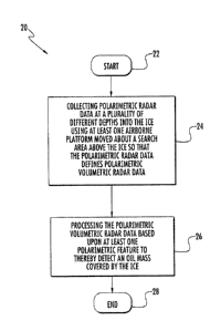
[0020] FIG. 1 is a flow chart for a method for
detecting an oil mass covered by ice using polarimetric
radar data in accordance with the present invention.
6
CA 02835883 2016-02-05
[0021] FIG. 2 is a schematic block diagram of a back
scatter system for detecting an oil mass covered by ice
using polarimetric radar data in accordance with the
present invention.
[0022] FIG. 3 is a more detailed flow chart
illustrating a method for detecting an oil mass under
ice using the single airborne platform illustrated in
FIG. 2.
[0023] FIG. 4 is a plot of dielectric loss for ice
as a function of frequency in accordance with the
present invention.
[0024] FIG. 5 is a schematic diagram representing a
polarimetric radar data cube used to provide a
scattering matrix defining a polarimetric depth slice
in accordance with the present invention.
[0025] FIG. 6 is a schematic block diagram of a
forward scatter system for detecting an oil mass
covered by ice using polarimetric radar data in
accordance with the present invention.
[0026] FIG. 7 is a more detailed flow chart
illustrating a method for detecting an oil mass under
ice using the multiple airborne platforms illustrated
in FIG. 6.
[0027] FIG. 8 is a flow chart for a method for
detecting an oil mass covered by ice using radiometric
volumetric data in accordance with the present
invention.
[0028] FIG. 9 is a schematic block diagram of a
system with a passively operated multi-band receiver
for detecting an oil mass covered by ice using
radiometric volumetric data metric radar data in
accordance with the present invention.
7
CA 02835883 2016-02-05
[0029] FIG. 10 is a flow chart illustrating a method
for detecting an oil mass under ice using the system
with the passively operated multi-band receiver
illustrated in FIG. 9.
[0030] FIG. 11 is a graph illustrating RF spectral
signatures for ice and an oil mass at different
frequencies with respect to a search area in accordance
with the present invention.
[0031] FIG. 12 is an energy map of the search area
reflecting operation of the passively operated multi-
band receiver in FIG. 9 at different frequencies.
[0032] FIG. 13 is a schematic diagram of a 3-
dimensional visualization of an oil mass based on
combined x-y-depth information data in accordance with
the present invention.
[0033] FIG. 14 is a schematic block diagram of a
system with an actively operated multi-band receiver
for detecting an oil mass covered by ice using
radiometric volumetric data metric radar data in
accordance with the present invention.
[0034] FIG. 15 is a flow chart illustrating a method
for detecting an oil mass under ice using the system
with the actively operated multi-band receiver
illustrated in FIG. 14.
[0035] FIG. 16 is a flow chart for a method for
detecting an oil mass covered by ice using coordinated
airborne and ground platforms in accordance with the
present invention.
[0036] FIG. 17 is a schematic block diagram of a
system using coordinated airborne and ground platforms
for detecting an oil mass covered by ice in accordance
with the present invention.
8
ak 02835883 2016-02-05
Detailed Description of the Preferred Embodiments
[0037] The present invention will now be described
more fully hereinafter with reference to the
accompanying drawings, in which preferred embodiments
of the invention are shown. This invention may,
however, be embodied in many different forms and should
not be construed as limited to the embodiments set
forth herein. Rather, these embodiments are provided
so that this disclosure will be thorough and complete,
and will fully convey the scope of the invention to
those skilled in the art. Like numbers refer to like
elements throughout, and prime notation is used to
indicated similar elements in alternative embodiments.
[0038] In Arctic regions, for example, a thickness
of ice may vary from a few centimeters to 5 meters. The
area to be searched when looking for a leaked oil mass
is typically within a predetermined area associated
with an oil extraction site or an oil pipeline site.
The oil extraction site may be an oil platform within
the Arctic waters, and the oil pipeline site may extend
away from the oil platform to deliver recovered crude
oil. As an example, the search area is about 10 km2
surrounding the oil platform and the oil pipeline site.
The search area is to be frequently searched to look
for changes indicative of a pocket of oil forming under
or trapped within a layer of ice, in other words, the
area is searched to detect a mass of oil covered by
ice. Those of skill in the art will recognize that the
oil mass will also be detected on the surface of the
snow or ice; however, an oil mass covered by ice
presents the more difficult detection challenge.
9
ak 02835883 2016-02-05
[0039] In addition, since the characteristics of ice
changes as a function of time and temperature, it may
be desirable to establish a baseline of the
environmental characteristics within the search area.
Since the thickness of ice and its salinity varies
throughout the season, this has an effect on the
penetration depth of the radar used to collect the
environmental characteristics.
[0040] One aspect of detecting an oil mass covered
by ice is based on the use of polarimetric volumetric
radar data. As will be discussed in greater detail
below, polarimetric volumetric radar data
advantageously allows an oil mass to be reliably
detected within the search area when covered by ice.
Once an oil mass is detected, its size and volume may
be determined based on the polarimetric volumetric
radar data.
[0041] Referring initially to the flowchart 20 in
FIG. 1, a method for detecting an oil mass covered by
ice includes, from the start (Block 22), collecting
polarimetric radar data at different depths into the
ice at Block 24 using at least one airborne platform
moved about the search area above the ice so that the
polarimetric radar data defines polarimetric volumetric
radar data. The polarimetric volumetric radar data is
processed at Block 26 based upon at least one
polarimetric feature to thereby detect an oil mass
covered by the ice. The method ends at Block 28.
[0042] In one embodiment, the at least one airborne
platform is a single airborne platform 50 as
illustrated in FIG. 2. In greater detail, a
corresponding method of detecting an oil mass 86
CA 02835883 2016-02-05
covered by ice 84 using the single airborne platform 50
is now explained with additional reference to the flow
chart 30 in FIG. 3. From the start (Block 32), the
single airborne platform 50 is moved about a search
area 80 at Block 34. The single airborne platform 50
includes spaced apart transmit and receive antennas 52,
54. The spaced apart transmit and receive antennas 52,
54 allow for bi-static operation of a radar 56 carried
by the single airborne platform 50. The single airborne
platform 50 is about 100 feet above the ice 84, for
example.
[0043] A transmitter 57 within the radar 56
transmits polarized signals 60 to the search area 80 at
Block 36. The polarized signals 60 include horizontal
polarization and vertical polarization, which are
orthogonal to one another. In lieu of or in additional
to the horizontal and vertical polarizations, left-hand
and right-hand circular polarizations may be used,
which are also orthogonal to one another.
[0044] A desired operating frequency of the radar 56
may be selected based on antenna size and penetration
depth of the polarized signals into the ice 84. As
readily understood by those skilled in the art, ice
acts as an insulator and a dielectric loss of the ice
varies with respect to frequency. As illustrated by
line 102 in the graph 100 provided in FIG. 4, the
dielectric loss of the ice 84 increases as the
frequency is lowered to the 10 MHz range. Within the
0.1-1.0 GHz frequency range, as highlighted by box 104,
a balance between dielectric loss and frequency is
obtained. In the illustrated example, the operating
frequency of the radar 56 is 0.1 GHz.
11
ak 02835883 2016-02-05
[0045] A receiver 58 within the radar 56 is operated
to receive reflected polarized signals 62 from the
search area 80 at Block 38 based on the transmitted
polarization signals 60 being reflected from the search
area. The return signals 62 provide a polarimetric
depth slice based on different measurements.
[0046] Referring now to FIG. 5, an illustrated
polarimetric radar data cube 110 is defined based on
the radar transmitter 57 transmitting vertically
polarized signals and horizontally polarized signals
60. The radar receiver 58 receives both horizontal and
vertically polarized signals 62 on corresponding
horizontally and vertically polarized antennas.
[0047] Still referring to FIG. 5, given these four
measurements, a polarimetric depth slice 112
represented by a scattering matrix S(d) is obtained.
The polarimetric depth slice 112 corresponds to the
polarimetric volumetric radar data being provided at
Block 40 to a data acquisition unit 72 carried by the
airborne platform 50. The illustrated data acquisition
unit 72 is included within a processor 70 coupled to
the radar 56. Alternatively, the data acquisition unit
72 may be configured as a memory 75 external the
processor 70 within the single airborne platform 50.
Of course, the processor may also include memory
embedded on the same integrated circuit as the
processor circuitry.
[0048] Each scattering matrix S(d) corresponds to a
particular depth. The depth is determined based on a
round trip time (RTT) of a transmitted polarization
signal 60 being reflected 62 and received by the radar
receiver 58. Since distance = rate * time, the longer
12
CA 02835883 2016-02-05
the radar receiver 58 waits to receive the return
signal, then the greater is the corresponding depth
into the ice 84. By adjusting the RTTs, different
scattering matrixes S(d) are obtained, where the
different scattering matrixes S(d) correspond to
different depths into the ice 84. The different
scattering matrixes S(d) are stored in the data
acquisition unit 72 or memory 75.
[0049] The different scattering matrixes S(d)
included within.the polarimetric radar data are
processed by a data processing unit 74 at Block 42. The
data processing unit 74 may be within the processor 70
carried by the single airborne platform 50, or
alternatively, the data processing unit may be external
the single airborne platform 50. In the illustrated
embodiment, the data processing unit 132 is located at
a remote command and control processing center 130.
(0050] Polarimetric volumetric radar data from the
data acquisition unit 72 may be provided to the data
processing unit 132 at the command and control
processing center 130 via a data link 78. The data link
78 includes an antenna 79 coupled thereto. The command
and control processing center 130 includes a
corresponding data link 134 with an antenna 135 coupled
thereto. Alternatively, the polarimetric volumetric
radar data may be on a removable data storage medium
that is physically inserted into the data processing
unit 132 at the command and control processing center
130.
[0051] When processing the polarimetric volumetric
radar data, polarization profiles are used to identify
boundaries of different layer or strata interfaces. The
13
CA 02835883 2016-02-05
layers making up the search area 80 are snow 82, ice
84, an oil mass 86 and water 88. The different layer
interfaces thus include a snow-to-ice interface 90, an
ice-to-water interface 92, an ice-to-oil interface 94,
and an oil-to-water interface 96. Each one of these
interfaces provides a different polarization profile
which can then be used to identify the particular type
of interface. By reliably determining the different
types of interfaces, when an ice-to-oil interface 94 or
an oil-to-water interface 96 is detected under the ice
84, then a reliable determination can be made that an
oil mass 86 has been detected.
[0052] In one embodiment, the radar 56 operates
based on pulses. To build up sufficient energy on a
target within the search area 80, a longer pulse width
may be used or multiple pulses are used. A pulse may be'
an impulse or pulse-compression with an appropriate
equalizer. In another embodiment, the radar 56 operates
based on a frequency modulated, continuous wave (FMCW)
waveform. An FMCW waveform is frequency agile and
adaptive, as readily appreciated by those skilled in
the art.
[0053] RF sounding may be used to adjust an
operating frequency of the radar transmitter 57 based
on the environmental conditions in the search area 80.
RF sounding allows characteristics of the ice 84 to be
determined at Block 44. Based on the determined
characteristics of the ice 84, such as thickness and
salinity, the operating frequency of the transmitter is
adjusted at Block 46.
[0054] RF sounding involves transmitting a signal to
the ice, and based on a return signal, the thickness of
14
CA 02835883 2016-02-05
the ice may be determined. Since ice acts as an
insulator, as illustrated by the graph 100 in FIG. 4,
the operating frequency may be adjusted up or down
depending on the thickness of the ice. As an
alternative to RF sounding, ice characteristics may be
determined based on preexisting geological surveys, for
example.
[0055] If the four different measurements within the
different scattering matrixes S(d) are not strong
enough to determine the different polarization
profiles, then other polarimetric features may be used.
For example, the other polarimetric features are
provided in TABLE 1 below, and include the following:
TABLE 1
#
Entropy 11
2 Anisotropy A
3 Polarimetric span
4 Mean scattering angle a
Alternative entropy Ai2
6 Standard deviation of CDP
7 Conformity coefficient it
8 Co-pol correlation coefficiern
9 Combined feature
Circular polarization coherence CPC
1 Bramlikelihood ratio
[0056] The scattering matrix S(d) may first be
represented as the following T matrix:
( 1Sn + Svvr) ((Sim + Svv )(Sim ¨ Svv)) 2 ((Stift + Svv),S)
I ,
T ¨ (kSHH ¨ Svv)(Stuf + Svv)) ( Nit ¨ Svv ;2) 2((Snil ¨
Svv)Shv
2
2 (Sfiv (SFin + Svv)*) 2(Skrv(Sfin ¨ Svvr) 4 (ISHvI2)
'="..
CA 02835883 2016-02-05
where the different T matrixes correspond to different
polarimetric depth slices 112, as illustrated in FIG.
5. One or more of the polarimetric features in TABLE 1
may be used for determining the different polarization
profiles.
[0057] In one such combination, an eigenvalue
decomposition on the T matrixes provides the value pi.
The value A. is then used to determine the entropy H, as
follows:
3
H = ¨p11og3p
P2 P3
A =
p2+pl
[0058] To get the anisotropy A, the less dominant
eigenvalues p2 and p3 are used. If the H and A
measurements are strong enough, then they may be used
to determine the different profile interfaces.
However, the if the H and A measurements are weak, then
the conformity coefficient may be calculated for using
the information in matrix T defining the polarimetric
depth slice 112, as follows:
2 (Re (SHHS:vv ) ¨ iSliV12)
I21 12 isvv12 = SHH12-1- 21SHv
[0059] Yet other features from TABLE 1 may be used,
as readily appreciated by those skilled in the art.
The method as illustrated in FIG. 3 ends at Block 48.
[0060] The single airborne platform 50 may be
piloted by a human, or it may be remote controlled via
16
CA 02835883 2016-02-05
the data link 134 at the command and control processing
center 130. In yet other alternative embodiments, the
single airborne platform 50 may be autonomously
controlled, such as a lighter-than-air aircraft
intended to hover over the search area 80 for extended
periods of time.
[0061] As an alternative to a single airborne
platform 50 allowing for bi-static operation, multiple
airborne platforms 200, 202 may be used allowing for a
forward scatter operation, as illustrated in FIG. 6. In
greater detail, a corresponding method of detecting an
oil mass 286 covered by ice 284 using first and second
airborne platforms 200, 202 is now described with
reference to the flow chart 230 in FIG. 7.
[0062] The first airborne platform 200 includes a
transmitter 257 and a transmit antenna 252 coupled
thereto. The second airborne platform 202 includes a
receiver 258 and a receive antenna 254 coupled thereto.
As an example, the first and second airborne platforms
200, 202 may be about 100 feet above the ice 284, and
may be separated by about 3 degrees off normal.
[0063] From the start (Block 232), the first and
second airborne platforms 200, 202 are moved about a
search area 280 at Block 234. The transmitter 257 in
the first airborne platform 200 is operated to transit
polarized signals 260 to the search area 280 at Block
236, and to also transmit a reference signal 261 to the
receiver 258 in the second airborne platform 202.
[0064] The receiver 258 in the second airborne
platform 202 is operated at Block 238 to receive
reflected polarized signals 262 from the search area
280 based on the transmitted polarization signals 260
17
CA 02835883 2016-02-05
being reflected from the search area 280, and to also
receive the reference signal 261 from the first
airborne platform 200. The reference signal 261
corresponds to a timing signal so that the receiver 258
in the second airborne platform 202 is coordinated with
the transmitter 257 in the first airborne platform 200
to allow processing of the polarimetric radar data.
[0065] The polarimetric radar data is provided at
Block 240 to a data acquisition unit 272 carried by the
second airborne platform 202. As with the single
airborne platform 50, the illustrated data acquisition
unit 272 is included within a processor 270 coupled to
the receiver 258. Alternatively, the data acquisition
unit 272 may be configured as a memory 75 external the
processor 270 within the second airborne platform 202.
[0066] The polarimetric radar data is processed by a
data processing unit 274 at Block 242 based upon at
least one polarimetric feature to thereby detect an oil
mass covered by the ice. As with the single airborne
platform 50, the data processing unit 274 may be within
the processor 270 carried by the second airborne
platform 202, or alternatively, the data processing
unit may be replaced or supplemented by a data
processing unit 332 at the command and control
processing center 330.
[0067] RF sounding may also be used to adjust an
operating frequency of the transmitter 257 based on the
environmental conditions in the search area 280. RF
sounding allows characteristics of the ice 284 to be
determined at Block 244. Based on the determined
characteristics of the ice 284, such as thickness and
salinity, the operating frequency of the transmitter
18
CA 02835883 2016-02-05
257 is adjusted at Block 246. The method ends at Block
248.
[0068] As discussed above, a forward scatter
operation is performed between the first and second
platforms 200, 202 to detect an oil mass 286 covered by
ice 284. Another forward scatter operation may be
performed between the first and second platforms 200,
202 when the second airborne platform 202 further
includes a transmitter and the first airborne platform
200 further includes a receiver. Operation of the
further transmitter and receiver is similar to
operation of the above discussed transmitter 257 and
receiver 258, and this need no further discussion
herein.
[0069] Another aspect of detecting an oil mass
covered by ice is based on the use of radiometric
volumetric data. As will be discussed in greater detail
below, radiometric volumetric data advantageously
allows an oil mass to be reliably detected within the
search area when covered by ice. Once an oil mass is
detected, its size and volume may be determined based
on the radiometric volumetric data.
[0070] Referring initially to the flowchart 400 in
FIG. 8, a method for detecting an oil mass covered by
ice includes, from the start (Block 402), collecting
radiometric data at Block 404 at a plurality of
different frequencies, corresponding to respective
different depths into the ice, using at least one
airborne platform moved about a search area above the
ice so that the radiometric data defines radiometric
volumetric data. The radiometric volumetric data is
19
CA 02835883 2016-02-05
processed at Block 406 to thereby detect an oil mass
covered by the ice. The method ends at Block 408.
[0071] In one embodiment, an airborne platform 450
with a multi-band receiver 452 is passively operated to
collect the radiometric volumetric data, as illustrated
in FIG. 9. In greater detail, a corresponding method of
detecting an oil mass 486 covered by ice 484 using
radiometric volumetric data is described with
additional reference to the flow chart 540 in FIG. 10.
From the start (Block 542), the airborne platform 450
is moved about a search area 480 at Block 544. The
airborne platform 450 includes a multi-band receiver
452 and a broadband aperture 454 coupled thereto. The
airborne platform 450 is about 100 feet above the ice
484, for example.
[0072] The multi-band receiver 452 is passively
operated at Block 546 to collect radiometric data at
different frequencies, corresponding to respective
different depths into the ice 484, so that the
radiometric data defines radiometric volumetric data.
Multi-band radiometry advantageously takes advantage of
energy differences in RF signatures of black-body
radiations with respect to an oil mass and ice to
reliably detect an oil mass covered by ice.
[0073] The multi-band receiver 452 is configured to
operate over a range of 30 MHz to 8 GHz, for example.
Based on IEEE frequency band designations, 30 MHz to 8
GHz corresponds to the following designations: VHF (30-
300 MHz), UHF (300-1000 MHz), L-band (1-2 GHz), S-band
(2-4 GHz) and C-band (4-8 GHz). Determining a depth of
the oil mass is advantageously exploited based on the
different penetration depths of the RF bands. The
CA 02835883 2016-02-05
operating range may be contiguous, meaning that the
multi-band receiver 452 operates at a frequency within
each band. In other embodiments, selected bands may not
be used so that the multi-band receiver 452 is non-
contiguous as will be appreciated by those skilled in
the art.
[0074] As illustrated in FIG. 9, the ice 484
provides an RF signature 490 having a certain energy
level, whereas the oil mass 486 has an RF signature 492
at a higher signature level. This is due the emissivity
of the oil mass 486 being greater than the emissivity
of the ice 484, as readily appreciated by those skilled
in the art.
[0075] A graph 560 illustrating RF spectral
signatures for ice and an oil mass at different
frequencies with respect to the search area 480 is
provided in FIG. 11. Curve 562 corresponds to the oil
mass 486 and curve 564 corresponds to the ice 484.
Reference 566 corresponds to L-band, whereas reference
568 corresponds to VHF. As illustrated, less black body
radiance at L-band allows for a shallower band when
creating a radiometric map. In contrast, there is more
black body radiance at VHF which allows for a deeper
band when creating the radiometric map.
[0076] An energy map 580 of the search area 480
reflecting operation of the passively operated multi-
band receiver 452 will now be discussed with reference
to FIG. 12. The x-y coordinates of the energy map 580
are based on overlapping energy maps of each individual
frequency band. For example, suspected oil pools 582 in
the energy map 580 are a result of a VHF energy map.
Possible oil pool 584 in the energy map 580 is a result
21
CA 02835883 2016-02-05
of an UHF energy map. The remaining area 586 represents
no oil detection and is a result of an L-band energy
map. The energy maps associated with S-band and C-band
also did not indicate any oil detection.
[0077] The radiometric volumetric data is provided
to a data acquisition unit 462 carried by the airborne
platform 450 at Block 548. The illustrated data
acquisition unit 462 is included within a processor 460
coupled to the multi-band receiver 452. Alternatively,
the data acquisition unit 462 may be configured as a
memory 470 external the processor 460 within the
airborne platform 450.
[0078] The radiometric volumetric data is processed
at Block 550 by a data processing unit 464. The data
processing unit 464 may be within the processor 460
carried by the airborne platform 450, or alternatively,
the data processing unit may be external the airborne
platform 450. In this configuration, the data
processing unit 512 is at a command and control
processing center 510.
[0079] Radiometric volumetric data from the data
acquisition unit 462 may be provided to the data
processing unit 512 at the command and control
processing center 130 via a data link 500. The data
link 500 includes an antenna 502 coupled thereto. The
command and control processing center 510 includes a
corresponding data 514 with an antenna 516 coupled
thereto. Alternatively, the radiometric volumetric data
is on a removable medium that is physically inserted
into the data processing unit 512 at the command and
control processing center 510.
22
ak 02835883 2016-02-05
[0080] Processing of the radiometric volumetric data
by the data processing unit 512 collected at the
different frequencies defines a combined x-y-depth
profile that may advantageously provide a 3-dimensional
visualization of the oil mass 486 covered by the ice
484, as perhaps best illustrated by the radiometric
profile 590 in FIG. 13. Reference 591 represents the
detected oil mass 486.
[0081] Operation of the multi-band receiver 452 may
be performed over a predetermined dwell time for a
given location. This advantageously allows a sufficient
energy level to be received so as to more accurately
process the radiometric volumetric data. The processing
may further include processing based upon at least one
polarization characteristic of the radiometric
volumetric data. Energy detectors for each band may be
used to provide soft decisions (multiple thresholds)
for inferring oil detection confidence between an
oil/ice mixture and an ice/water column that is
passively interrogated.
[0082] The multi-band receiver 452 may be operated
at a plurality of different times, which allows the
processing to further include using change detection
based upon the plurality of different times to detect
the oil mass covered by the ice. The method ends at
Block 552.
[0083] The airborne platform 450 may be piloted by a
human, or it may be remote controlled via the data link
514 at the command and control processing center 510.
In yet other alternative embodiments, the airborne
platform 450 may be autonomously controlled, such as a
23
CA 02835883 2016-02-05
lighter-than-air aircraft intended to hover over the
search area 480 for extended periods of time.
[0084] The multi-band receive 452 may be configured
with a separate receiver for each frequency band. The
broadband aperture 454 may be a single aperture with a
number of different feeds corresponding to the
different frequency bands. Alternatively, separate
antennas may be used in lieu of the broadband aperture
454. As a further alternative, the broadband aperture
454 may be configured as a phased array.
[0085] Another aspect of detecting an oil mass
covered by ice using radiometric volumetric data
includes an actively operated multi-band receiver 452',
as illustrated in FIG. 14. A transmitter 453' and an
antenna 455' coupled thereto is carried by the airborne
platform 450'. In greater detail, a corresponding
method of detecting an oil mass 486' covered by ice
484' using radiometric volumetric data is provided by
the flow chart 600 in FIG. 15.
[0086] From the start (Block 602), the airborne
platform 450' is moved about a search area 480'. A
transmitter 453' carried by the airborne platform 450'
is operated at Block 606 to expose the search area 480'
with EM radiation. The search area 480' is exposed to
EM radiation having a frequency resonant with the oil
486'. This advantageously allows a stronger energy
signature for the oil mass 486' to be detected. The EM
radiation may have a frequency in a range of 8 MHz to
30 MHz, for example.
[0087] The multi-band receiver 452' is actively
operated at Block 608 to collect radiometric data at a
plurality of different frequencies, corresponding to
24
CA 02835883 2016-02-05
respective different depths into the ice, so that the
radiometric data defines radiometric volumetric data.
The radiometric volumetric data is provided to a data
acquisition unit 462' carried by the airborne platform
450' at Block 610. The radiometric volumetric data is
processed at Block 610 to thereby detect an oil mass
486' covered by the ice 484'. The method ends at Block
612.
[0088] Another aspect of detecting an oil mass
covered by ice is based on using coordinated airborne
and ground platforms to provide a very high probability
of detection at a particular location. Once an oil mass
is detected, then appropriate remedial action may be
taken. Since the probability of detection is very high,
time and cost are not wasted on false alarms.
[0089] Referring now to FIGS. 16 and 17, a flowchart
950 and corresponding system for detecting an oil mass
754 covered by ice 752 using coordinated ground and
airborne platforms 700, 800 will be discussed. From the
start (Block 952) in the flow chart 950, alert data is
collected at Block 954 at a first probability of
detection using at least one airborne platform 800
moved about a search area 750 above the ice 754. An
alert area outlined by cone 801 is determined at Block
956 having a likelihood of an oil mass 756 covered by
the ice 754 based upon the alert data.
[0090] Confirmation data is collected at Block 958
at a second probability of detection higher than the
first probability of detection using a ground platform
700 moved over the alert area 801. An oil mass 756
covered by the ice 754 is detected at Block 960 based
upon the confirmation data. A confirmation area
CA 02835883 2016-02-05
outlined by cone 701 is within the alert area 801. The
method ends at Block 962.
[0091] The airborne platform 800 includes a radar
802. The radar 802 includes a transmitter 804 and a
receiver 806. Spaced apart transmit and receive
antennas 805, 807 are respectively coupled to the
transmitter and receiver 804, 806. Alert data collected
by the radar 802 is provided to a data acquisition unit
812. The illustrated data acquisition unit 812 is
included within a processor 810 coupled to the radar
802.
[0092] The alert data is provided to a data
processing unit 814 that may also be included within
the processor 810. The data processing unit 814
determines the alert area having a likelihood of an oil
mass covered by the ice based upon the alert data. This
is performed having a first probability of detection. A
data link 816 having an antenna 818 coupled thereto
interfaces with the processor 810.
[0093] The illustrated ground platform 700 includes
a wideband impulse radar 702, an acoustic radar sensor
704 and a LIDAR sensor 706 to collectively provide the
confirmation data to a data acquisition unit 712. The
data acquisition unit 712 is within a processor 710
within the ground platform 700.
[0094] Information on the alert area as determined
by the airborne platform 800 is provided to the ground
platform 700 via data links 716, 816. In particular, a
contour map of the surface of the alert area is
provided to the ground platform 700. Since the ground
platform 700 is mobile, the contour map is
advantageously used to avoid cracks and crevices that
26
CA 02835883 2016-02-05
may cause the ground platform to become stuck or turned
over on its side.
[0095] The confirmation data is provided to a data
processing unit 714 that may also be included within
the processor 710. The data processing unit 714
determines the oil mass 756 covered by the ice 754
based upon the confirmation data. The data processing
unit 714 has a second probability of detection higher
then the first probability of detection. A data link
716 having an antenna 718 coupled thereto interfaces
with the processor 710.
[0096] In lieu of the data processing unit 814
determining the alert area in the airborne platform 800
and the data processing unit 714 determining the oil
mass 756 in the ground platform 700, the respective
data used for this processing may be transmitted via
data links 816, 716 to a command and control processing
center 900.
[0097] The command and control processing center 900
includes a processor 902 performing these functions via
a data processing unit 904 and data processing unit
906. A data link 908 with an antenna 910 coupled
interfaces with the processor 902 for providing the
collected alert data received via data link 816 at the
airborne platform 800, and the collected confirmation
data received via data link 716 at the ground platform
700.
[0098] In one embodiment, the ground platform 700
is manned and the airborne platform 800 is unmanned.
The airborne platform 800 is controlled by the command
and control processing center 900 via the data links
908, 816. In another embodiment, the airborne platform
27
CA 02835883 2016-02-05
800 is manned, and the ground platform 700 is unmanned.
The ground platform 700 is controlled by the command
and control processing center 900 via the data links
908, 716. In yet another embodiment, both the ground
and airborne platforms 700, 800 are unmanned and are
controlled by the command and control processing center
900.
[0099] The radar 802 within the airborne platform
may be a synthetic-aperture radar (SAR). Alternatively,
the radar 802 may be a circular polarization diversity
synthetic-aperture radar data. The Circular
Polarization Ratio (CPR) will be used to distinguish
between returns from ice and oil deposits in ice.
[00100] The first probability of detection may be
less than or equal to 80%, and the second probability
of detection may be greater than or equal to 99%. In
addition, the insulator characteristics of the oil mass
756 will produce a capacitive effect similar top a
parallel-plate capacitor when interrogated by an RF
electromagnetic field. The equivalent RC circuit
ringing depends on a size of the oil mass 756 (i.e.,
area and volume) and penetration of the RF signal. A
time constant RC determines a ringing duration, as
readily appreciated by those skilled in the art.
[00101] The various different oil detection
techniques as described herein may be used individually
or may be combined with one another as will be
appreciated by those skilled in the art. In addition,
many modifications and other embodiments of the
invention will come to the mind of one skilled in the
art having the benefit of the teachings presented in
the foregoing descriptions and the associated drawings.
28
CA 02835883 2016-02-05
Therefore, it is understood that the invention is not
to be limited to the specific embodiments disclosed,
and that modifications and embodiments are intended to
be included within the scope of the appended claims.
29