Note: Descriptions are shown in the official language in which they were submitted.
CA 02837051 2013-11-21
WO 2012/160409 PCT/1B2011/001585
METHOD OF PROCESSING SEISMIC DATA
BY PROVIDING SURFACE OFFSET COMMON IMAGE GATHERS
BACKGROUND OF THE INVENTION
[0001] The present invention relates to methods of processing seismic
data.
It is applicable in the field of geophysical prospecting when images of the
subsurface are needed.
[0002] To obtain images of the subsurface, a seismic method is often
used,
which consists in creating and sending seismic waves in the ground using
sources such as explosives or vibrator trucks on land, or airguns offshore.
The
seismic waves penetrate the ground and get bounced, or reflected off
geological discontinuities in the subsurface. As a result, they come back to
the
surface, where they are recorded using arrays of three component geophones
(on land), or hydrophones (offshore) which are regularly distributed to cover
areas of several square kilometers.
[0003] Figure 1 illustrates diagrammatically a survey of seismic data with
a
source S of seismic waves and an array of receivers G. It also shows a point B
of the subsurface which is assumed to contribute to the signal sensed by one
of
the receivers G. The horizontal coordinates of point B of the subsurface are
denoted by x, y (or only one spatial coordinate if 2D imaging instead of 3D
imaging is considered), while its depth is denoted by z. Figure 1 also
provides a
simplified representation (dashed lines) of the propagation of seismic waves
from the source S to the point B and from the point B to the receiver G. The
waves are refracted at discontinuities of the geological layers where the
acoustic impedance changes and reflected or diffracted at different positions
including that of point B.
[0004] The data recorded in a seismic survey include, for each shot
from a
source S and for each receiver G, a seismic trace which is a time series of
the
signal sensed by the receiver G. The traces for a number of shots must be
transformed to provide an image of the subsurface which will be the result of
stacking or integrating a large amount of information. An important step of
the
CA 02837051 2013-11-21
WO 2012/160409 PCT/1B2011/001585
- 2 -
transformation is the migration which consists in rearranging the data with
respect to a model such that the stacking can be carried out coherently. The
model is usually a map of the propagation velocity of the acoustic waves in
the
subsurface. It is not known a priori and it is a main challenge of all seismic
imaging technologies to determine a model that will properly account for the
field data after stacking.
[0005] In pre-stack depth migration (PSDM) methods, migrated data are
computed for each shot using the velocity model and arranged in an output
cube containing migrated values associated with positions in the subsurface.
The cubes obtained for different shots are then analyzed to check consistency
of the model. The model may be corrected and the process is iterated until a
satisfactory image is obtained.
[0006] Common Image Gathers (CIGs) are popular tools for evaluating
the
migration velocity field and for imaging enhancement. They are made of data
extracted from the output cubes, sorted in a convenient way for analysis so as
to check the velocity model. A CIG is a bi-dimensional data structure defined
for a given horizontal position x, y, with a first axis representing the depth
z and
a second axis representing a domain parameter A referred to for sorting the
data of the output cubes. It contains reflectivity values obtained from the
output
cubes resulting from the migration, forming an image which can be analyzed to
check and/or correct the velocity model. In this image, a pixel value at a
point
(z, A) represents a migrated value derived as a contribution of the subsurface
position x, y, z to a seismic trace associated with the domain parameter A.
Examples of commonly used domain parameters A include the surface offset,
namely the distance between the source location for a shot and the receiver
location providing the relevant trace for that shot, or the scattering angle
at the
subsurface position x, y, z.
[0007] The computation of common image gathers is not straightforward
in
all wavefield extrapolation methods. In fact, to date, depending on the
propagation method employed to perform the migration, the output cubes are
sorted in different ways. Even if there is no theoretical reason for this, the
most
practical way to produce common image gathers is selected according to
CA 02837051 2013-11-21
WO 2012/160409 PCT/1B2011/001585
- 3 -
different types of migration.
[0008] For example, scattering angle CIGs or surface offset CIGs are
of
widespread use in ray-based tomography techniques, to look for the velocity
model which gives 'flat gathers'. Figures 2A-C illustrate the principle in the
case
of surface offset CIGs. We consider a flat reflector at a position x0, y0, z0
of the
subsurface. If the velocity model is correctly estimated, the reflector will
provide
a peak in the migrated signal at depth z0 for all values of the offset h, thus
giving a flat event in the CIG as shown in figure 2A. If, however, the
migration
velocity is overestimated in the model, the same peak observed at the same
o time in a seismic trace will be associated with a larger depth value z1
as shown
in figure 2B, and the corresponding event in the CIG will have a concave shape
since the discrepancy in the wave travel time increases with the offset h.
Likewise, if the migration velocity is underestimated in the model, the peak
will
be associated with a shallower value z2 as shown in figure 2C, and the
corresponding event in the CIG will have a convex shape. If the reflector has
a
non-zero dip angle, its image in the CIG will be shifted horizontally in
addition to
vertically. Different tools have been developed to analyze the surface offset
CIGs in order to correct the velocity model.
[0009] However, such tools have been used mostly in migration methods
based on estimation of travel times between reflectors and the surface. More
sophisticated migration methods have been developed to build PSDM images
by solving the wave equation so as to obtain more accurate reflector
amplitudes and structural positioning. For example, reverse-time migration
(RTM) is a two-way migration solution which can accurately describe wave
propagation in complex media. It is increasingly used in seismic exploration
by
virtue of advances in computer power and programming.
[0010] The above-mentioned analysis tools are not used with wave
equation PSDM methods, including RTM, because it is not known how to
compute surface offset CIGs.
[0011] In "Offset and angle-domain common image-point gathers for shot-
profile migration", Geophysics, Vol. 67, No. 3, 2002, pp. 883-889, J. Rickett
and
CA 02837051 2013-11-21
WO 2012/160409 PCT/1B2011/001585
- 4 -
P. Sava established the notion of subsurface offset CIGs which requires the
extension of the imaging condition through the computation of the correlation
function along the spatial horizontal dimension. This type of gathers is the
most
common way to output wavefield-based migration images. It is better suited to
techniques based on focusing analysis, which look for the highest correlation
at
zero-time lag and/or zero-offset. In "Angle-domain common image gathers by
wavefield continuation methods", Geophysics, Vol. 68, No. 3, 2003, pp. 1065-
1074, P. Sava and S. Fomel proposed a method to derive scattering angle
CIGs from subsurface offset CIGs. More recently, the same authors, by
combining both time and depth, introduced the concept of extended image
condition in "Time-shift imaging condition in seismic migration", Geophysics,
Vol. 71, No. 6, pp. 209-217.
[ow 2] Despite their benefits, some issues prevent the generalized
usage of
subsurface offset and angle gathers. Firstly, since RTM is a computer-
intensive
process, the computation of the cross-correlations for all the selected CIG
locations adds a considerable extra cost. Secondly, subsurface offset gathers
cannot be employed for classical tomography. The analysts cannot benefit from
the full arsenal of tools developed for classical surface or angle CIGs (like
RMO, Mute, AVO/AVA analysis, etc.). Subsurface scattering angle CIGs would
be suited for this goal. However, these gathers imply an additional cost for a
two-parameter Radon transform, and they do not show the correct kinematic
move-out.
[0013] It would be desirable to obtain surface offset gathers with
different
kinds of migration methods, in particular wavefield methods including RTM, so
as to keep the advantages of wavefield methods and, at the same time,
address the limitation of the asymptotic assumption of ray-based methods,
while sorting the migrated cubes in the same way as classical surface offset
gathers.
SUMMARY OF THE INVENTION
[0014] A method of processing seismic data is proposed to provide
CA 02837051 2013-11-21
WO 2012/160409 PCT/1B2011/001585
- 5 -
common image gathers in the surface offset domain. The method comprises:
- inputting seismic data including, for each of a plurality of shots at
respective source locations, seismic traces recorded at a plurality of
receiver locations;
- applying a depth migration process to the seismic data to obtain a first set
of migrated data including, for each shot, first migrated values
respectively associated with a plurality of subsurface positions;
- computing offset-modulated data by multiplying the seismic data in each
seismic trace by a horizontal offset between the source and receiver
lo locations for said seismic trace;
- applying the depth migration process to the offset-modulated data to
obtain a second set of migrated data including, for each shot, second
migrated values respectively associated with the plurality of subsurface
positions;
- for each shot, estimating offset values respectively associated with at
least some of the subsurface positions, by a division process applied to
the first and second sets of migrated data; and
- estimating a common image gather at a horizontal position, comprising
respective migrated values for parameter pairs each including a depth
parameter and an offset parameter.
[0015]
The migrated value for a parameter pair in the common image
gather at a horizontal position is a first migrated value of the first set of
migrated data associated with a subsurface position determined by said
horizontal position and the depth parameter of said parameter pair for a shot
such that the estimated offset value associated with said subsurface position
is
the offset parameter of said parameter pair.
[0016]
The surface offset gathers can be obtained without referring to the
traditional Kirchhoff paradigm which is based on an infinite frequency
approximation of the wave equation and ray tracing. The method is thus
applicable to various kinds of depth migration processes, including wave
equation pre-stack depth migration (WEPSDM) processes. In a preferred
CA 02837051 2013-11-21
WO 2012/160409 PCT/1B2011/001585
- 6 -
embodiment, the depth migration process is a reverse-time migration (RTM)
process.
[0017] RTM provides a better propagator than ray tracing. Therefore,
it
allows producing CIGs in complex areas like sub-salt, complex overburden,
etc., somewhat closer to the "true" offset gathers. Furthermore, since the
sorting of the output is the same, the conventional Kirchhoff offset gathers
can
be replaced by the CIGs obtained by means of the method as input of most of
the standard post-processing tools. Because of years of know-how in Kirchhoff-
type migration, this method allows for an easier interpretation of the
migrated
results. Compared to subsurface CIGs, it also requires much less
computational effort to compute the gathers. Furthermore, these gathers are
potentially suited for wave-path tomography.
[0018] For achieving an improved stability, the division process used
for
estimating the offset values associated with a subsurface position may
comprise minimizing a cost function defined by an offset variable and local
values of the first and second migrated values in a neighborhood of the
subsurface position.
[0019] Another aspect of the invention relates to a system for
processing
seismic data, comprising computer resource configured to carry out a method
of analyzing seismic data as defined above.
[0020] Yet another aspect of the invention relates to a computer
program
product for a system for processing seismic data, comprising instructions to
carry out a method as defined above when said program product is run in a
computer processing unit of the system.
[0021] Other features and advantages of the method and apparatus
disclosed herein will become apparent from the following description of non-
limiting embodiments, with reference to the appended drawings.
BRIEF DESCRIPTION THE DRAWINGS
[0022] Figure 1 is a schematic diagram illustrating the acquisition of
seismic
CA 02837051 2013-11-21
WO 2012/160409 PCT/1B2011/001585
- 7 -
data.
[0023] Figures 2A-C show simplified CIGs computed using different
migration velocity values.
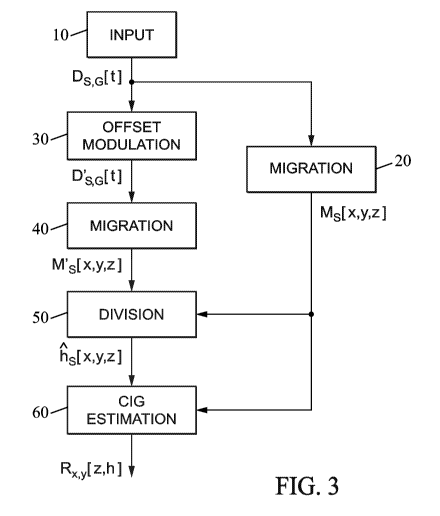
[0024] Figure 3 is a flowchart of a method of processing seismic data
in
accordance with an embodiment of the invention.
[0025] Figure 4 is a diagram illustrating the derivation of surface
offset CIGs
in accordance with the method.
[0026] Figures 5A-5B show input data for the migration process in a
simple
example simulated by means of the proposed method.
[0027] Figures 6A-6B show migration results in this example, and figure 6C
shows the attribute estimation resulting from the division of the results.
[0028] Figure 7 is a diagram showing part of a surface offset CIG
obtained
by applying the method in the above-mentioned example.
DESCRIPTION OF EMBODIMENTS
[0029] One way to obtain surface offset CIGs for WEPSDM or RTM
migration methods would be to compute one migration per shot and per trace,
requiring a number of migrations equal to the total number of shots times the
average number of receivers per shot. This is clearly impractical for the time
being, especially for 3D cases. Instead, it is proposed to use a more feasible
solution, namely attribute migration, also called double migration.
[0030] In the double migration method as introduced by N. Bleistein
("On
the imaging of reflectors in the earth", Geophysics, Vol. 52, No. 7, July
1987,
pp. 931-942), two migrations are computed with the same data, the second one
involving a migration operator multiplied by the specular reflection angle.
The
division of the two migrated images then gives the specular angle along the
reflectors.
[0031] A similar method can be used with the surface offset instead of
the
specular reflection angle as the migrated attribute. The migration can be
CA 02837051 2013-11-21
WO 2012/160409 PCT/1B2011/001585
- 8 -
performed using various PSDM methods including standard shot-record RTM.
[0032] The methodology then comprises:
- performing a first standard RTM migration (step 20 in figure 3);
- performing a second offset attribute RTM migration, where the data are
multiplied by the offset values prior to migration (steps 30 and 40 in figure
3);
- perform a division of the two migrated data obtained, in a least square
sense, to obtain the offset (step 50 in figure 3);
- add the reflectivity obtained from the first migrated data to the
corresponding subsurface and offset gather location given by the
obtained attribute map to reconstruct surface offset CIGs (step 60 in
figure 3).
[0033] In
this way we are able to obtain classical surface offset CIGs using
a WEPDSM migration method such as RTM which is the best extrapolation
method available nowadays for seismic migration.
[0034] In
figure 3, the seismic traces input in step 10 from the field
measurements are noted Ds,G[t], where S denotes a source location, G
denotes a receiver location and t is for time. Each trace is modulated in step
30
by multiplying it by the corresponding offset value, namely the horizontal
offset
hs,G between the source location S and the receiver location G. The offset-
modulated traces are D's,G[t] = hs,G=DS,G[t].
[0035] The seismic data Ds,G[t] and offset-modulated data D',0[t] are
respectively migrated in steps 20 and 40 to provide PSDM data Ms[x,y,z] and
M's[x,y,z]. The first set of migrated data produced in step 20 includes, for
each
shot at a source location S, a cube of migrated values Ms[x,y,z] associated
with
subsurface positions x, y, z. Likewise, the second set of migrated data
obtained
in step 40 using the same depth migration process includes another cube of
migrated values M's[x,y,z] for each shot.
[0036] In order to estimate an offset value fis[x, y, 4 for a migrated
value
CA 02837051 2013-11-21
WO 2012/160409 PCT/1B2011/001585
- 9 -
Ms[x,y,z], i.e. a value for a shot S and a subsurface position x, y, z, a
division
process is performed in step 50 to evaluate M's[x,y,z]/Ms[x,y,z].
[0037] A
raw division of the two numbers may give rise to stability issues.
Instead, it may be better to cast the division as a set of local least square
problems. The offset value Fis[x, y, z] is then found by minimizing a cost
function Js(h) defined in a neighborhood S2(x,y,z) centered on the location
x, y, z. A possible expression of the cost function Jsocy,z(h) is:
1 2
JS,x,y,z(h) = ¨2 5 Ma [u w].h ¨ M'a [u v w] du.v.w
S "v S " dd
(1)
(u,v,w )e cgx,y,z)
where rkq[x,y,z] = Ms[x,y,z] + i.H(Ms[x,y,z]) is the analytic signal of the
reflectivity, H denoting the Hilbert transform, and
M1 [x, y,z] = M's[x,y,z] + i.H(M's[x,y,z]). The size of the neighborhood
51(x,y,z)
is variable and can depend on the application. It is selected such that the
value
of the migrated attribute h can reasonably be assumed to be constant over
S2(x,y,z) for a given shot.
[0038] The offset values fis[x,y,z] may then be contained as:
5 M' as [u, v, w].(M; [u, v, w]) du.dv.dw
lis[x,y,z] = Argmin0s (h))= "
, \ i/(x y z)
x,y,z
(2)
h 5 M;[u,v,w].(MZ[u,v,w]) du.dv.dw
f(x,y,z)
where the superscript (.)* denotes the Hermitian. Note that the upper part of
the
right-hand side of equation (2) is the cross-correlation of the two images,
the
standard migrated image and the attribute-migrated image. The lower part is
the auto-correlation of the standard migrated image, or the envelope. In this
way, the stability of the division is increased.
[0039] The offset values lis[x,y,z] thus obtained are used to map the
reflectivity values Ms[x,y,z] to corresponding offsets h, which reflectivity
values
can then arranged as surface offset CIGs at the horizontal positions x, y:
CA 02837051 2013-11-21
WO 2012/160409 PCT/1B2011/001585
- 10 -
Rx,y [z, h] = iMs [x, y, z].o(h ¨ h5 [x, y, 4)
(3)
S
[0040] This process of computing the surface offset CIGs is
illustrated in the
diagram of figure 4. The offset attribute is obtained by the 'double migrated'
map division. The two upper panels of the diagram depict two common shot
migrated images showing a horizontal reflector. The first image is obtained by
means of Reverse Time migration of plain seismic data, while the second is the
output of migration where the data have been multiplied by the offset h. In
this
panel, amplitudes vary laterally along the reflector and are proportional to
the
receiver position and, therefore, to the offset. In particular, starting from
the left
side, the amplitude is negative, it reaches zero exactly below the source
position and becomes positive afterwards.
[0041] For a specific position (xo, zo) in the shot migrated image
(here, the
horizontal position xo may be 2D, with x and y components), we have a
particular value of reflectivity R. At the same position in the attribute-
migrated
image, the value of the reflectivity is R multiplied by the offset h, which is
the
offset of the source/receiver couple that generated the specular reflection.
The
offset is simply the division of the two quantities. With these four values
(xo, zo, h, R), we can now build the migrated offset cube. The lower panel the
diagram of figure 4 represents a common-midpoint section at the location Xo.
The contribution of the reflectivity R is added to the position whose
coordinates
are given by the couple depth/offset (zo,h).
[0042] A numerical example can be presented to illustrate the above
described method. In this example, the model is a 2D constant velocity 5 km in
depth and 8 km in horizontal displacement rectangle. The velocity is assumed
to be 2000 m/s and P-reflection data were generated by means of acoustic
Born modeling introducing eight discontinuities every 500 m starting from 1
km.
An amplitude-versus-offset (AVO) anomaly, where the reflection changes its
polarity every 2000 m in offset, was simulated. Taking advantage of the de-
facto 1D geometry, a full seismic survey can be represented by using only one
source. That source is located at 3000 m, at a depth of 5 m below the surface.
CA 02837051 2013-11-21
WO 2012/160409 PCT/1B2011/001585
- 1 1 -
The receivers are located at the same depth, on the right side of the source
every 25 m, starting from the source position. Figure 5A shows the input
common shot gather Ds,G[t], while figure 5B shows the attribute-multiplied
data
D's,G[t]. Note how the amplitudes are emphasized by the modulation for larger
offsets.
[0043] For more simplicity, a Frequency domain propagator was employed
for migration in the simulation. A constant velocity model for the
propagation,
where the velocity is higher than the true velocity and equal to 2200 m/s, was
taken. The obtained results are compared with the theoretical move-out which
can be computed analytically for simple models. Additionally, correct
detection
of the AVO anomaly can be checked. For each data set and for each shot, two
images are obtained.
[0044] Figure 6A-B shows the shot-migrated results for the data
provided
where the source is located at 3000 m. The plain migrated data Ms[x,z] are
displayed in figure 6A, while the attribute-migrated data M's[x,z] are
displayed
in figure 6B. Unsurprisingly, amplitudes are emphasized by the modulation
going from the left to the right of the acquisition. This behavior can be seen
in
figure 6B which represents the attribute obtained after division of the first
two
images. The estimation of the attribute occurs at the points on the reflectors
for
which there is a specular pair of rays from the source and the receiver to the
surface point being imaged. At locations where this is not satisfied, i.e.
where a
non-zero reflectivity cannot be identified, the values of the attribute are
not
significant. By means of the obtained attribute map, the contribution of the
reflectivity is then added at the corresponding offset position. To obtain the
final
offset migrated image, the contributions over all the shots are summed.
[0045] Figure 7 shows a zoom of the surface offset gather obtained
from
shot-geophone wave equation prestack depth migration with the same model
parameters as in the previous section. In particular, it depicts two
reflectors
located at 1500 m and 2000 m in depth. Because of the error in the migration
velocity, they are mispositioned and they exhibit a non-flat move-out. Also
shown by solid lines in figure 7 are the theoretically predicted z(h) curves.
As
CA 02837051 2013-11-21
WO 2012/160409 PCT/1B2011/001585
- 12 -
the figure demonstrates, the match is pretty good and the AVO anomaly is
correctly detected.
[0046]
The proposed method to obtain classical surface gathers for various
PSDM techniques including Reverse Time migration showed to be successfully
applicable in the context of band-limited propagation. The proposed methods
do not depend on a particular implementation of wave-field extrapolation
method, since it can be performed after shot-record migration in Fourier
domain, time domain, etc.
[0047] An
advantage of this method is that it allows the use of better
o
propagators than rays to propagate the wave-field, making it possible to adopt
the full arsenal of standard tools for post-processing developed for
asymptotic
migration schemes. Compared to Subsurface-Offset and Scattering Angle
Subsurface-Offset, Surface Offset for RTM CIGs are way less expensive to
compute, and they preserve the kinematic move-out.
[0048] The
embodiments of the method described herein may be
implemented on any form of computer or computers and the components may
be implemented as dedicated applications or in client-server architectures,
including a web-based architecture, and can include functional programs,
codes, and code segments. Any of the computers may comprise a processor, a
memory for storing program data and executing it, a permanent storage such
as a disk drive, a communications port for handling communications with
external devices, and user interface devices, including a display, keyboard,
mouse, etc.
[0049] Typically, the method is carried out using software modules
which
may be stored as program instructions or computer readable codes executable
on the processor on a computer-readable media such as read-only memory
(ROM), random-access memory (RAM), CD-ROMs, magnetic tapes, floppy
disks, and optical data storage devices. The computer readable recording
medium can also be distributed over network coupled computer systems so
that the computer readable code is stored and executed in a distributed
fashion. This media is readable by the computer, stored in the memory, and
CA 02837051 2013-11-21
WO 2012/160409 PCT/1B2011/001585
- 13 -
executed by the processor.
[0050] It will be appreciated that the embodiments described above are
illustrative of the invention disclosed herein and that various modifications
can
be made without departing from the scope as defined in the appended claims.