Note: Descriptions are shown in the official language in which they were submitted.
CA 02837165 2013-11-22
WO 2012/160331
PCT/GB2012/000459
1
A METHOD TO AID IN THE EXPLORATION, MINE DESIGN, EVALUATION
AND/OR EXTRACTION OF METALLIFEROUS MINERAL AND/OR DIAMOND
DEPOSITS
BACKGROUND OF THE INVENTION
Field of the Invention
The present invention relates to a technique to aid in the exploration, mine
design, evaluation
and/or extraction of metalliferous mineral and/or diamond deposits in a
subsurface, in
particular to a technique using seismic surveying for that purpose.
Description of the Related Art
Seismic exploration has been used in the search and exploitation of
hydrocarbon deposits.
Surveys have been conducted both on land and in water and involve surveying
subterranean
geological formations. This is done by recording at least one seismic source
(e.g.
acoustic/sonic) using at least one seismic sensor. The seismic source does not
need to be
man-made or at an accurately known location. Natural or (more likely) induced
seismic
events may be used as passive sources. The passage of elastic energy in the
form of seismic
waves from the source to the sensor is effected by geological formations.
Therefore
information received at the sensor contains information regarding the
geological formations
which have effected the seismic wave on its passage from the source to the
sensor. For
example, geological formations can reflect seismic waves. The data received by
the sensor is
conditioned and processed to generate seismic data along with information
regarding the
source(s) and the location of the source(s) and sensor(s). The seismic data
may be analysed to
determine the likelihood of the presence and location of hydrocarbon deposits.
A technique which has been used for analysing seismic data is wavefield
tomography
(sometimes referred to as waveform tomography, wavefield inversion or waveform
inversion).
For mining applications, in particular for mining minerals other than
hydrocarbons (for
example non-carbonaceous minerals, and/or metalliferous and/or diamond
deposits, and/or
minerals excluding petroleum and/or excluding coal and/or excluding coalbed
methane) post-
CA 02837165 2013-11-22
WO 2012/160331
PCT/GB2012/000459
2
recognisance high-resolution exploration and evaluation is usually limited to
the drilling of
bore holes and analysis of extracted cores. This has been in part due to the
more accessible
nature of sites of interest which are usually on land (as opposed to under the
sea) and which
deposits must not be found too deep so as otherwise to hamper extraction and
because of the
need for a higher resolution of the information regarding various deposits and
because of the
necessity to evaluate the grade of the ore to be extracted. For such tasks,
three-dimensional
full-wavefield seismic tomography has not been considered.
Summary of Invention
The present invention provides a method to aid in the exploration, mine
design, evaluation
and/or extraction of metalliferous mineral and/or diamond deposits in a
subsurface, the
method comprising:
= providing three-dimensional seismic data acquired in a seismic survey of
the
subsurface;
providing an initial model of the subsurface;
performing wavefield tomography at least partly as a function of at least one
property
of the subsurface in three-dimensions using the initial model and the seismic
data to generate
an updated model; and
determining an estimate of the at least one property of the subsurface from
the updated
model.
The advantage of using this 3D full wavefield seismic tomographic technique is
not only the
location of the deposits but also physical properties of the deposits,
adjacent, overlying and
underlying rock units can be estimated at a higher resolution in three
dimensions than is
realistically possible with drilling alone and 2D seismics and other
geophysical methods.
Additionally, making the estimate of at least one property of the subsurface
may be less
expensive using the invention than a borehole survey. This is because the
generation of
seismic data may be significantly less expensive than the generation of
multiple boreholes.
Additionally, the present invention may be an adjunct to the drilling of bore
holes. Fewer
drill holes may be required, and/or the technique may provide additional
information about
physical properties that it is not possible to determine from drill holes and
cores.
CA 02837165 2013-11-22
WO 2012/160331
PCT/GB2012/000459
3
The technique of the present invention may be faster than drilling to
establish a model of the
structure of the subsurface.
The technique of the present invention is more easily repeatable than drilling
¨ e.g. as a mine
is developed, to monitor changes in the sub-surface.
The technique of the present invention will often be less invasive, and have a
smaller
environmental footprint than drilling.
Additionally, the technique of the present invention can be used where
physical access,
environmental, safety, legal or other issues limit physical drilling.
Additionally, the technique of the present invention can be used where
drilling provides a
particular environmental hazard as a consequence of the material extracted
e.g. poisonous
and/or radio-active deposits.
Additionally, the technique of the present invention can be used when drilling
may potentially
damage ground-water systems e.g. by changing ground water flow/pressure and/or
changing
chemistry/poisoning ground water.
The wavefield tomography is performed to estimate at least one property of the
subsurface in
three dimensions. This allows the initial model to be optimised according to
the property
which is of interest, allowing a more accurate estimate of that property to be
made than is
present in the initial model.
In an aspect there is provided a method of collecting seismic data, comprising
using a
plurality of receivers to record seismic waves resulting from explosions used
in block caving
to build a block caving mine. This way of collecting seismic data is
particularly efficient as
the explosions used as sources have the dual functionality of both building
the mine and
excavating deposit as well as generating seismic data. Preferably the seismic
data is used in a
method to aid in the exploration, mine design, evaluation, and or extraction
of metalliferous
mineral and /or diamond deposits in a subsurface by using the seismic data in
wavefield
tomography along with an initial model to generate an updated model; and
determining an
estimate of at least one property of the subsurface from the updated model.
In an aspect there is provided as computing apparatus to perform the method as
well as
computer program to perform the method.
CA 02837165 2013-11-22
WO 2012/160331
PCT/GB2012/000459
4
Brief Description of the Drawings
The invention may be understood by reference to the following description
taken in
conjunction with the accompanying drawings, in which like reference numerals
identify like
elements, and in which:
Figure 1 depicts schematically, in cross-section, how a seismic survey may be
conducted in a
subsurface;
Figure 2 depicts schematically the method of the present invention;
Figure 3 illustrates how a cavity and/or a non-planar top surface of a
subsurface may be
treated.
DETAILED DESCRIPTION OF THE INVENTION
In mining applications it is useful to be able to predict the location and
mechanical properties
of a subsurface (e.g. a section of the earth), particularly of parts of the
earth which are capable
of trapping deposits of interest.
Deposits of interest may include metalliferous mineral and/or diamond deposits
and/or non
carbonaceous minerals, that is, deposits excluding petroleum and/or excluding
coal and/or
excluding coalbed methane).
Knowledge of properties of the subsurface may be useful in exploration (i.e.
deciding where
suitable deposits may lie), in mine design (e.g. in deciding upon the
structure of the mine), in
evaluation (for instance in estimating the quality of a deposit) and/or
extraction (e.g. in
helping decide where and the size of explosives to be placed during extraction
of deposits).
The present invention is directed at a method which can aid in those
activities.
The present invention is also directed to a method of exploration for
metalliferous mineral
and/or diamond deposits, a method of metalliferous mineral and/or diamond mine
design, a
method of evaluation of metalliferous mineral and/or diamond deposits and/or a
method of
extraction of metalliferous mineral and/or diamond deposits in a subsurface.
CA 02837165 2013-11-22
WO 2012/160331
PCT/GB2012/000459
The method of the invention will be described with reference to Figure 1 which
is a cross-
section through a subsurface 1000 which contains as a geological formation
deposits 50 (for
example metalliferous mineral and/or diamond deposits) shown in diagonal cross-
hatching
from top left to bottom right, as illustrated.
In block cave mining (a block cave mine is shown as 20 in Figure 1) ore of the
deposit is
allowed to collapse due to its own weight under gravity in a controlled
fashion. Block caving
is usually used to mine large ore bodies that are deeply buried, and that have
significant
vertical extent in comparison to their horizontal extent. Explosives are
sometimes used in
underground block caving and detailed information regarding not only the
location of the ore
but also its mechanical properties and/or the mechanical properties of
surrounding regions, is
extremely useful. In block caving, the mine is engineered so that the ore body
collapses from
below in a controlled fashion. Potential problems are that the ore body fails
to collapse at all,
that collapse ceases at some point during extraction of the ore, that the
collapse proceeds in
unforeseen directions, or at an unforeseen rate, and especially that it
proceeds outside the
desired ore body and/or proceeds rapidly to the surface, and/or that the
fractured ore produced
by the collapse is not of an optimal size for subsequent processing being
either too large or
too fine to handle easily within the mine. These potential problems can have
safety and
environmental as well as economic consequences. A detailed knowledge of the
physical
structure of the subsurface, and its detailed mechanical properties, in three
dimensions, is
required in order to be able to predict with confidence how a block cave will
form and evolve
as the ore is produced. Such knowledge is therefore important in mine design,
in mine
operations, and in evaluation of a potential mine site.
For a deep mine such as that illustrated in Figure 1 and labelled 30,
properties of the deposit
of interest may include the location of the deposit such that decisions
regarding at which
levels and in which directions to extend galleries from a main shaft can be
made. Information
regarding the mechanical properties of the deposit 50 and/or of other
geological formations
60, 70, 80, 90 (which are not be mined) may also be of interest. Such
information may be
useful in determining the likely strength of galleries and thereby may be used
in mine design,
evaluation and/or actual extraction of deposits.
The present invention uses seismic surveying techniques to survey the
subsurface and thereby
determine an estimate of at least one property of the subsurface. The property
of the
subsurface may be a property of any one of the geological formations 50, 60,
70, 80 and 90.
CA 02837165 2013-11-22
WO 2012/160331
PCT/GB2012/000459
6
The property may be a property at a particular location irrespective of the
type of geological
formation 50, 60, 70, 80 and 90. The property of interest is desirably a
property of the deposit
50.
Examples of properties of the subsurface which may be estimated are the
location of deposits
and other geological formations within the subsurface, the mechanical,
elastic, anelastic and
anisotropic properties of deposits and other geological formations within the
subsurface, the
intensity, scale, orientation and detailed character and geometry of
fracturing, faulting,
jointing, micro-cracking, folding, lineation, foliation, lamination, layering,
bedding and
heterogeneity of deposits and other geological formations within the
subsurface, and the
density, porosity, pore geometry, fluid content, fluid pressure, mineral
alignment, mineral
orientation, and state of stress of deposits and other geological formations
within the
subsurface. Any combination of the above properties may be determined.
This information may be used in exploration and evaluation where possible
sites for mining
are being investigated, in mine design, for example in determining the shape
of the mine
and/or where explosives might best be positioned, particularly during block
cave mining, in
the evaluation of an existing mine, for example how best to expand the mine,
and in the actual
extraction of the deposit (for example what techniques to use/where to place
explosives).
For applications of seismic surveys in mining, a high resolution is required.
For example, a
higher resolution than is used in petroleum exploration is desired and in
particular knowledge
of physical properties, for example mechanical properties of the geological
formations 50, 60,
70, 80, 90 in the subsurface as well as their location are desired. Properties
deducible from
seismic survey data may be related to the desired mechanical property.
As with seismic surveys for hydrocarbon deposits, one or more sources 130 of
seismic waves
and one or more receivers 130 of seismic waves (for example sensors sensitive
to pressure
changes (hydrophones) and/or sensors sensitive to particle motion (e.g.
geophones and/or
accelerometers)) may be deployed on or near the top surface 10 of the
subsurface 1. In this
arrangement the seismic survey relies on reflection, diffraction and back-
scattering of seismic
energy from interfaces between geological formations 50, 60, 70, 80, 90, and
upon the
refraction, diffraction and forward scattering of seismic energy within as
well as between
geological formations 50, 60, 70, 80, 90.
CA 02837165 2013-11-22
WO 2012/160331
PCT/GB2012/000459
7
Preferably the three-dimensional seismic data is generated by at least one
source and/or at
least one receiver in the subsurface. During seismic surveying for hydrocarbon
deposits,
usually the sources and receivers are positioned on or at the surface of the
subsurface, or
within the water column or on the seabed of a marine survey. Placing sources
and/or
receivers underground in the subsurface is possible inexpensively in mining
applications,
particularly when subsurfaces at or in proximity to existing mines are of
interest. In an
existing mine it is relatively easy and cheap to place sources and/or
receivers within the mine
and thereby in the subsurface. The placing of sources and/or receivers in the
subsurface leads
to greater obtainable resolution, particularly near to geological formations
which may be of
interest (e.g. deposits).
Sources 120 and/or sensors 120 may be placed vertically in a one dimensional
array in a bore
hole(s) or shaft(s) of a mine under the subsurface 1000. This can help in
increasing the
resolution of the seismic survey. In mining applications at least one
source/sensor 120 may
be positioned in a vertical shaft of a mine, thereby doing away with the need
for drilling of a
specific bore hole.
Preferably a plurality of sources and/or plurality of receivers are in a multi-
dimensional array
in the subsurface. This is not possible to achieve with a single borehole and
mines are
particularly suited to the arrangement of a plurality of sources and/or
plurality of receivers in
a multi-dimensional array. This further improves the achievable resolution
even further over
a one-dimensional array in the subsurface. In the case of a mine, it may be
possible to arrange
the multi-dimensional array substantially in a plane. This has both
geometrical advantages in
terms of the achievable resolution as a result as well as computational
advantages in terms of
efficient wavefield tomography in terms of grid generation and/or computation.
Sensors and/or sources 110 may be placed in a substantially horizontal array
in a gallery of a
mine. Preferably sensors/sources 110 in a gallery of a mine are positioned in
a multi
dimensional (e.g. two or three dimensional) array in the subsurface 1000. This
increases the
achievable resolution compared to the case of sensors and/or sources
positioned in a one
dimensional array in the subsurface 1000. Pioviding the sources/sensors in a
two dimensional
array substantially in a plane makes modelling during the below described
wavefield
tomography easier to implement. A seismic survey may include data from any
combination
of locations described above. Each location may have exclusively sources, may
have
exclusively receivers or may have a combination of sources and receivers. Each
location
CA 02837165 2013-11-22
WO 2012/160331
PCT/GB2012/000459
8
described 110, 120, 130 (and 140 below) may have no source, may have no
receiver or may
have one or more sources or one or more receivers.
During a seismic survey seismic energy is released into the subsurface 1000
through sources.
Seismic waves (compressional (P) waves and/or shear (S) waves) pass from the
source(s)
through the geological formations 50, 60, 70, 80, 90 and/or are reflected
and/or refracted
and/or diffracted and/or scattered and/or absorbed by the geological
formations 50, 60, 70, 80,
90 in a path to a sensor. In response to detected seismic events, the
sensor(s) generate
electrical signals indicative of the seismic events. These signals form part
of the seismic data
acquired in the seismic survey. The seismic data also includes information
regarding the
position of the sensors and sources and additionally information regarding the
seismic energy
released by the sources.
Analysis of the seismic data as described below, can provide an estimate of at
least one
property of a deposit 50 and/or a geological formation 60, 70, 80, 90 which is
not to be mined.
The property may relate to the location of geological formations 60, 70, 80,
90 or deposit 50,
or mechanical properties of the geological formation 60, 70, 80, 90 or deposit
50. A
mechanical property may be information regarding fractures in the geological
formation 60,
70, 80, 90 or deposit 50 as described above.
In one embodiment a seismic source 140 may be an explosion used in the block
caving
process. This allows seismic surveys to be carried out economically because
the source of the
seismic energy is being provided for another purpose thereby improving
efficiency.
Additionally, the position of the source close to the geological formation 60,
70, 80, 90 or
deposit 50 of interest helps achieve high resolution.
Because multiple sources or receivers have been used, arranged in a multi-
dimensional array,
the results of the seismic survey are a three-dimensional seismic data.
Estimates of at least one property of the deposit 50 can be made from actual
seismic data by
using the technique of wavefield tomography (sometimes called waveform
tomography,
wavefield inversion or waveform inversion).
Wavefield tomography refers to the derivation of one or more properties of the
subsurface
1000 from the three dimensional actual seismic data. This is achieved by
modelling the
passage of the seismic energy emitted by the sources in a seismic survey and
varying
CA 02837165 2013-11-22
WO 2012/160331
PCT/GB2012/000459
9
parameters of a model of the subsurface 1000 until a good fit between a
synthetic seismic data
generated by the modelling predicted to be received at the positions of
sensors closely
matches that of the actual seismic energy received by sensors in the actual
seismic data.
Parameters of the model of the subsurface 1000 describe the positions of
geological
formations 50, 60, 70, 80, 90 by way of their varying properties (primarily
velocity of seismic
energy through them). After each comparison between synthetic seismic data and
actual
seismic data, the model is changed in an iterative process until a good fit
(for example as
determined by a least squares analysis) is achieved between the actual and the
synthetic
seismic data.
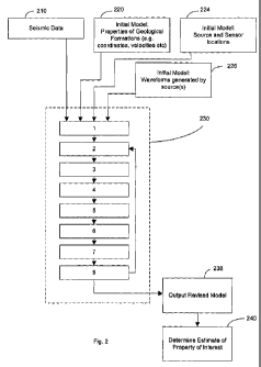
Figure 2 is a schematic flow chart illustrating how a wavefield tomography
step 230 is
incorporated into the method.
First-three dimensional seismic data is acquired as described above, in step
210.
An initial model of the subsurface 1000 is provided in step 220. The initial
model is generally
the current best guess of the properties relevant to the propagation of
seismic energy at each
grid point of a grid covering the subsurface 1000. The initial model includes,
for each
position of a grid, parameters relating to the geological formation 50, 60,
70, 80, 90 present at
the location of the grid point.
In an embodiment each grid point may have more than one parameter associated
with it. The
parameter(s) associated with each grid point depend upon the type of wave
equation and the
symmetry of the anisotropy. Usually each grid point will have a density
associated with it,
plus up to 21 independent elastic moduli, and up to 21 independent anelastic
moduli ¨ more if
these are themselves frequency dependent (which they are unlikely to be over
the range of
frequencies that are available). These 43 properties can be combined in
various ways to make
other dependant properties, for example p-wave velocity, or s-wave velocity,
and if the
anisotropy has various types of symmetry or is absent entirely, then many of
these parameters
are not independent. Where a priori rock physics and/or bore hole information
is available,
combinations of these parameters can be used, together with quantitative
measurements on
their geometric properties to obtain derived higher-order properties. For
example, if the
anisotropy in a certain unit is known or assumed to be related to oriented
fractures, then the
fracture density, aspect ratio, orientation, fluid content, connectivity, and
so forth can be
CA 02837165 2013-11-22
WO 2012/160331
PCT/GB2012/000459
constrained. These properties in turn may be related to the state of stress in
the rock unit and
its strain history.
The parameters except density vary both with propagation direction and with
polarisation
orientation ¨ that is three waves all travelling in the same direction will
potentially travel with
three different velocities as their polarisation are in three mutually
orthogonal directions.
Therefore, these parameters may be modelled as being anisotropic meaning that
the parameter
is different for different directions. This is particularly relevant for
mining applications in
that the prediction of anisotropic properties of geological formations 50, 60,
70, 80, 90 can be
related to particular physical properties at the grid point such as the
presence and direction of
fractures.
An initial starting model of the source 120 and sensor 120 locations is
provided in step 224.
A starting model for the waveforms generated by the source(s) is provided in
step 226.
The three dimensional seismic data from step 210, the initial model from step
220, the starting
model of source/receiver locations from step 224 and the starting model for
the waveforms
generated by the source(s) from step 226 are fed to the wavefield tomography
step 230. Any
type of wavefield tomography may be used.
In overview, in wavefield tomography synthetic seismic data is calculated. In
this calculation
step the information regarding the sources of the seismic survey (position of
sources and
sensors and properties of the seismic energy) as well as the initial model are
used to predict a
forward and backward wavefield between the sources(s) and sensors, given the
assumptions
in the initial model. The passage of seismic energy in a direct path from a
source to a sensor
as well as in an indirect path (for example a path in which the energy is
reflected one or more
times) is calculated. Variations in the speed of the seismic energy through
the geological
formations 50, 60, 70, 80, 90 and the position of any interfaces between
geological formations
50, 60, 70, 80, 90 and thereby the position of reflections all effect the
wavefields.
After forward and backward wavefields have been calculated a gradient is
determined by
comparison of those two wavefields.
The gradient is then used to update the model.
The updated model is then used to generate new forward and backward wavefields
which are
again compared to generate a new gradient which is used to update the model.
The loop is
CA 02837165 2013-11-22
WO 2012/160331
PCT/GB2012/000459
11
followed until the comparison between the forward and backward wavefield
indicates an
acceptable degree of match between the synthetic seismic data and the actual
seismic data. At
this point the wavefield tomography 230 proceeds to step 238 at which a
revised model is
output.
Examples of techniques used in wavefield tomography are described in, for
example,
Tarantola, A., (1984) Inversion of seismic reflection data in the acoustic
approximation.
Geophysics, 49, 1259-1266 which relates to basic acoustic theory; Tarantola, A
(1986) A
strategy for nonlinear elastic inversion of seismic reflection data.
Geophysics, 51, 1893-1903
which relates to basic elastic theory; Mora, P. R. (1987) Nonlinear two-
dimensional elastic
inversion of multioffset seismic data. Geophysics, 52, 1211-1228 which relates
to the
beginnings of a practical method; Mora, P. R. (1989) Inversion-migration-
tomography.
Geophysics, 54, 1575-1586 which parallels with other methodologies; Pratt, R.
G., Song, Z.-
M., Williamson, P., and Warner, M. (1996) Two-dimensional velocity models from
wide-
angle seismic data by wavefield inversion. Geophysical Journal International,
124, 323-340
which is a demonstration on surface wide-angle data¨ synthetic, 2D; Pratt, R.
G. (1999)
Seismic waveform inversion in the frequency domain, Part 1: Theory and
verification in a
physical scale model. Geophysics, 64, 888-901 which develops theory in the
frequency-
domain; Graham J. Hicks and R. Gerhard Pratt (2001) Reflection waveform
inversion using
local descent methods: Estimating attenuation and velocity over a gas-sand
deposit.
Geophysics, 66, 598-612 which includes a demonstration for attenuation; Shipp,
R. M., and
Singh, S. C., (2002) Two-dimensional full wavefield inversion of wide-aperture
marine
seismic streamer data. Geophysical Journal International, 151, 325-344 which
is a time-
domain demonstration on field data ¨ 2D, elastic; Sirgue L & Pratt RG (2004)
Efficient
waveform inversion and imaging: A strategy for selecting temporal frequencies.
Geophysics,
69, 231-248 which is a further development of the use of the frequency-domain;
and
Changsoo Shin and Young Ho Cha (2008) Waveform inversion in the Laplace
domain.
Geophys. J. Int. 173, 922-931 which is a demonstration in Laplace domain. US
2010/0042391 describes wavefield tomography in the Laplace-Fourier domain.
Example details of a computational method of wavefield tomography in step 230
will now be
described with reference to the eight stages illustrated in Figure 2. In the
method stages 2-8
are repeated until an acceptable degree of accuracy has been reached.
CA 02837165 2013-11-22
WO 2012/160331
PCT/GB2012/000459
12
1. Start from the observed seismic data, a starting model of physical
properties, a starting
model of source/receiver locations, and a starting model for the waveforms
generated by
the source. In most cases the source/receiver locations will be known
accurately, but they
may be included in the inversion ¨ especially if the sources are
passive/induced rather
than generated deliberately.
2. Pre-process the observed seismic data, and/or transform it into another
domain or
domains, and/or form composite sources and/or composite receivers by combining
sub-
sets of data together, and or apply reciprocity to exchange the positions of
source and
receivers. The pre-processing may include, but is not limited to, changing the
temporal
and/or spectral and/or spatial amplitudes of the data, adjusting the phase and
timing of the
data, deconvolving and/or convolving in space and/or time, mixing, windowing,
muting,
multi-dimensional filtering in space, time, frequency and/or other domains.
The pre-
processing may be data dependant and/or model dependent and/or deterministic.
The total
number of sources or composite sources included in each iteration may be
greater than,
equal to, or less than the number of actual physical sources.
3. For each source (or composite source) that is included in the current
iteration, calculate
the wavefield within all or part of the current model of physical properties
and at one or
more receiver (or composite receiver) locations using an appropriate wave
equation
(examples are given below). The resulting wavefield within the model and at
the receiver
locations is called the forward wavefield.
4. Apply pre-processing to the calculated forward wavefield at each receiver
or composite
receiver. This pre-processing need not be identical to that applied to the
observed data,
and it may be data dependent ¨ on both the calculated and observed data.
Compare the
pre-processed calculated data with the pre-processed observed data, and
extract a new
wavefield that results from this comparison at each receiver. At its simplest,
this
comparison may be a simple point-wise subtraction of the two datasets, but it
may involve
instead for example the difference between the weighted summed datasets at
each
receiver, the phase difference between the two wavefields at one or more
frequencies, the
point-wise difference of their absolute values, the point-wise difference
between their
envelopes, or other measures of similarity. The result of this comparison
maybe further
pre-processed, after which, for each source, it forms a wavefield at the
receivers that is
termed the residual dataset.
CA 02837165 2013-11-22
WO 2012/160331
PCT/GB2012/000459
13
5. By considering the receivers (or composite receivers) as sources (or
composite sources),
propagate the residual wavefield from the receivers backwards in time into the
model
towards the original source and towards the heterogeneities within the model
that
generated the forward wavefield. This produces a wavefield within all or part
of the
model that is termed the backward wavefield. There will be one such backward
wavefield
and a corresponding forward wavefield for each original source.
6. By comparison of the forward and backward wavefields throughout the
model, and by
further processing, generate an unsealed update to the original model. This is
termed the
gradient. The simplest means of generating the gradient is to cross-correlate
the forward
and backward wavefields in time at every point in the model for every original
source,
taking the zero-lag of this correlation, and adding together the results from
every source.
The data used to generate the gradient, and/or the raw gradient, may be
weighted spatially
and/or smoothed in space and/or convolved and/or deconvolved in space and/or
processed
in other ways to obtain a modified gradient, and/or the forward and backward
wavefields
may be pre-processed prior to cross-correlation. The pre-processing of the
wavefields,
and the processing of the raw gradient may be data and/or model dependant.
7. The gradient is used to perturb the original model in one or more ways.
Optionally, new
synthetic data are generated using this perturbed model or models. This allows
the
calculation of further residual datasets. By having regard to the degree to
which these
new residual datasets compare to the residual datasets calculated at stage 4
and /or to the
effect of previous model updates obtained during previous iterations, and/or
to the
roughness and/or other statistical measures of model heterogeneity, and/or
deviation from
an a priori starting model, and/or closeness to other known or assumed
geometric,
statistical, structural or physical property information, an optimal update to
the original
model is determined. For example, by perturbing the starting model by a small
amount in
the direction indicated by the gradient, and assuming a linear relationship
between
changes in data residuals and model perturbation, the total model perturbation
required to
minimise the least-squares sum of the residuals can be predicted. If required,
similar .
considerations can be applied also to update the source wavefield, and/or
source/receiver
geometry.
8. Using the model update obtained at stage 7, the original model is updated.
The source
waveform and/or the source timing and/or the source locations and/or receiver
locations
CA 02837165 2013-11-22
WO 2012/160331
PCT/GB2012/000459
14
may also be updated. The sub-set of data to be inverted, and its pre-
processing may be
changed, and the process iterated with the new model, new sources and
receivers, and new
pre-processed observed data, starting the process a new from stage 2.
Iteration proceeds
until the model updates fall below some satisfactory threshold, or some other
predetermined limit is reached, for example the number of iterations or total
computer
time required.
During calculation of synthetic seismic data (stages 3 and 5), P and/or S
waves may be
modelled. P-waves can be considered the analogue of sound waves in solids. S-
waves are
transversely polarised waves that can only exist in solids ¨ not fluids ¨ they
involve only a
change in shape of the medium not any change in volume. If only the acoustic
wave equation
is solved, only p-waves are modelled. If the elastic wave equation is solved,
both p- and s-
waves are modelled. If modest elastic anisotropy is used, the shear-wave speed
depends upon
polarisation as well as direction of travel ¨ the two shear waves split. If
strong elastic
anisotropy is used, then the differences between p and s waves can become less
clear.
In one embodiment the wavefield tomography includes generating synthetic
seismic data by
solving an acoustic wave equation.
This is computationally the least demanding approach ¨ fast, inexpensive, less
memory and
time and fewer processors are required. It appears to be more robust in that
it is less likely to
generate spurious results. The acoustic wave equation is better understood and
hence easier
to parameterise. The acoustic wave equation is more straightforward to code.
On given
hardware, the acoustic wave equation is can use the largest models.
The model used to calculate the synthetic seismic data may solve an acoustic
wave equation.
The acoustic wave equation is:
1 a2p
c
-7at 2
This is written for acoustic pressurep in the time-domain where t is time, c
is the acoustic
wave speed, p is density, s is the acoustic source function in space and time,
and V is the del
operator in three dimensions. c and p are functions of position, and p is a
function of time and
position.
CA 02837165 2013-11-22
WO 2012/160331
PCT/GB2012/000459
To solve this in the time domain by explicit finite-differences, using a
regular rectangular
mesh in space, and at regular steps in time. The differential operators are
replaced by finite
difference operators. The solution proceeds by stepping the solution forward
in time.
Because the solution at every point on the mesh is known at earlier times,
solution at the next
time step can be calculated by applying the wave equation approximated by
finite differences.
The method is long-established, and there are many variations of detail.
In the frequency domain, the analogous equation is
¨S
where P and S are the temporal Fourier transforms of p and s, and w is
frequency.
In this case, when a finite difference approximation is applied to the spatial
operator, a set of
large, sparse matrix equations, one equation for each frequency, is derived.
These can either
be solved by direct factorisation, but in 3D this has large memory
requirements which make it
impractical for large models, or by iterating from an approximate solution.
The latter has
much smaller memory requirements for large models.
In one embodiment the wavefield tomography includes generating synthetic
seismic data by
solving an elastic wave equation.
This emulates the physics of seismic wave propagation more accurately than
does the acoustic
wave equation. It calculates wave amplitudes more accurately, and so can
extract more
information from a given dataset. It can determine shear-wave properties. It
can determine
density with less uncertainty than acoustic methods. It can deal with fluid
properties within
pore space more accurately. In principle, it therefore provides more accurate
models for a
wider range of properties than does the acoustic wave equation. The
computational cost
however is more than ten times as much, and may be up to 100 times as much in
some
circumstances.
The model used to calculate the synthetic seismic data may solve an elastic
wave equation.
The elastic wave equation can be written in many forms; one such in the time
domain is:
CA 02837165 2013-11-22
WO 2012/160331
PCT/GB2012/000459
16
patit = 9,Cra...r ay Try + az Tx z
pacz) ---d1 Tcy + ay Tyy azTyz
pattb = 19x7rz ayTy, azrzz
atTs., = (A + 2)8st.L+ A(ayi) + 3,1h)
atTyy = (A + 2/./.)ayi) + A(asit +
atTzz = (A + 21L)az1i) + A(axu-+
at:T:7:y 2,a(ayit + axi))
atTxz =-- 2ii(azit + 6.00
OtTyz = 2/-0.zi)
Here p is density, 1.1 is the shear modulus, and k is the second Lame
parameter. The
differential operators operate in time at, and in three space directions, 0õ,
ay and a,. The six
independent components of stress are given by T, where the superscripts refer
to the
orientation of the component thus r,õ, is a normal component of stress in the
x-direction, and
txy is a shear component of stress in the y-direction over a plane
perpendicular to the x-
direction, and txy = Trõ and ü, i) and i are particle velocity in the three
space directions.
The equation is typically solved by explicit time stepping in the time domain
in a way that is
analogous to the acoustic wave equation. Typically however the stresses and
particle
velocities are solved on different meshes that are staggered by have a cell in
space and by half
a time step in time.
In one embodiment the wavefield tomography includes generating synthetic
seismic data by
solving a visco-acoustic wave equation.
This allows the proper incorporation of anelastic losses (i.e. attenuation)
into the algorithm.
This models amplitudes more accurately than does the acoustic wave equation.
It allows the
extraction of anelastic properties which in turn relate to fracturing, sub-
seismic-wavelength-
scale heterogeneity, fluid content and state of stress which are important in
mining
applications.
The model used to calculate the synthetic seismic data may solve a visco-
acoustic wave
equation. In the frequency domain, the viscose-acoustic wave equation is
identical to the
acoustic wave equation with the addition that the acoustic velocity c becomes
complex, where
the real part of c represents a velocity and the imaginary part is related to
the Q-factor which
CA 02837165 2013-11-22
WO 2012/160331 PCT/GB2012/000459
17
in turn relates to the attenuation. The resulting equations are solved
identically to those for
the acoustic wave equation, but the velocity is complex throughout.
In the time domain, the equation involves the solution of an integral over
frequency at every
time step. This is a computationally expensive operation, and various
approximations to it
may be used in order to speed up the computation.
In one embodiment the wavefield tomography includes generating synthetic
seismic data by
solving a visco-elastic wave equation
This combines the advantages of elastic and visco-acoustic above. It provides
a proper
account of amplitudes. It can recover shear-wave anelastic properties. It can
recover p-wave
an-elastic properties with more certainty and accuracy. However, it is the
most expensive
approach, and least robust.
The model used to calculate the synthetic seismic data may solve an visco-
elastic wave
equation. This equation is similar to the elastic equation, but it contains
additional terms that
control the attenuation. The equation is expensive to solve, and various
approximations to it
can be made in order to speed up the computation. The appropriate
approximation depends
upon the model of attenuation that is assumed, and is only generally accurate
over a limited
bandwidth.
The equation is typically solved by explicit time stepping.
Whichever wave equation(s) are solved in the model, the equations may include
parameters
which are anisotropic. In this case, the speed of propagation of a wave
depends upon both its
direction of propagation and its direction of polarisation. In strongly
anisotropic media, the
distinction between p and s-waves becomes blurred, with waves typically
manifesting
intermediate properties.
Preferably the wave equation solved in generating synthetic seismic data
accounts for
anisotropic properties of the medium through which the wave propagates. In
particular, .
estimating the anisotropic properties of the deposit can provide information
relating to
oriented meso and micro-structure, for example fractures, faults, joints,
folds, foliations,
laminations, layering, bedding, pore space, state of stress, and mineral
orientation and
alignment, which may in turn influence rock-mechanical properties.
Particularly for block
CA 02837165 2013-11-22
WO 2012/160331
PCT/GB2012/000459
18
cave mining information regarding fractures and mechanical properties of the
deposits can be
useful in aiding mine design and extraction of the deposits.
In the most general, elastic, anisotropic medium, each grid cell is
characterised by 21
independent elastic moduli that each relate one component of stress, to one
component of
strain, plus density. If this general medium is also anisotropic and an-
elastic, a further 21
independent moduli are required to describe the anisotropic attenuation.
Anisotropic media can locally display various degrees of symmetry. Such
symmetry reduces
the number independent moduli. For example, if a purely elastic medium
displays local
rotational symmetry about a vertical axis, then five moduli plus density are
adequate to
describe the medium at each grid point.
Anisotropy is of particular importance in mining applications because many
properties of
interest lead to anisotropy in elastic and an-elastic properties. The
orientation and aspect
ratios of fractures, faults and joints, and the micro and meso structure of
folds, laminations,
foliations, lineations, bedding and other layering, and mineral and pore-space
alignment and
orientation all affect anisotropy and all can be related to mechanical and
other physical
properties in geological formations 50, 60, 70, 80, 900.
Therefore, including elasticity, anelasticity and anisotropy into the wave
equation gives more
parameters for each grid point, and this can increase the achievable
resolution, and increase
the volume of usable information that can be extracted from the data. In the
simplest form of
elliptical acoustic anisotropy, two rather than one elastic parameter can be
extracted at every
grid point. At its most general, a fully visco-elastic formulation with
arbitrary anisotropy will
in principle allow 43 independent, frequency-independent, parameters to be
extracted at each
grid point, or an arbitrarily large number if these properties vary with
frequency.
In one embodiment the wavefield tomography is at least partly implemented in
the time
domain. In one embodiment the wavefield tomography is at least partly
implemented in the
frequency domain. In one embodiment the wavefeld tomography is at least partly
implemented in the Laplace domain. The wave equation is transformed into the
particular
domain chosen, and solved it there ¨ the modelling, the observed data, the
processing, is done
in that new domain. In a hybrid method parts are performed in one domain and
other parts in
another domain, either to save some computational effort of because particular
steps are more
effective in one domain than another. In principle, the transforms that are
used to go from
CA 02837165 2013-11-22
WO 2012/160331
PCT/GB2012/000459
19
one domain to another are reversible, so, apart from the cost of the transform
it is possible to
move between domains at any point in the computation.
The wavefield tomography may at least be partly implemented in the time
domain, and/or the
frequency domain, and/or the Laplace domain.
Principal considerations that determine which domain to use are accuracy,
speed of
computation, ease and type of computational parallelisation, amount of memory
required per
processor, total memory required, ease of quality control, stability,
sensitivity of the results to
noise in the input data, to inaccuracies in the starting model, to
inaccuracies in the geometry
and/or source waveform, and to sparse and missing data, and whether elastic,
anisotropic
and/or anisotropic effects are to be included. In general, the frequency
domain is fastest and
allows easy implementation of anelasticity, the time domain is most robust
against noise and
data sparsity, is easiest to QC, and is straightforward to parallelise on
simple hardware, and
the Laplace domain is most robust against inadequacies in the starting model.
Hybrid
methods, in which the synthetic data are computed in one domain, but the
tomography is
undertaken in another domain (e.g. US 7,725,266), or in which different
domains are used in
different iterations or on different parts of the model or data, attempt to
combine the
advantages of more than one domain, or overcome specific limitations of one
domain.
The revised model produced in step 238 is a model of the subsurface in which
each grid point
is assigned parameters according to the updated model. These parameters are
indicative of
properties of the subsurface at the location of the grid point and can be used
to determine an
estimate of a property of interest in step 240. The property of interest may
be property of a
deposit 50 and/or a property of a geological formation 60, 70, 80, 90 and/or
may be a property
indicative of what type of geological formation is present at the grid point.
In one embodiment the synthetic seismic data (e.g. stage 3 and 5) is
calculated using a finite
difference method. Finite-difference formulations are generally the fastest,
the simplest to
program and QC, and require the least memory. They are straightforward to
optimise and to
parallelise, and their performance and limitations are well understood under a
wide variety of
conditions.
In an embodiment the synthetic seismic data is calculated using a finite
element method.
Finite-element formulations are able to match the geometry of complicated
boundaries
explicitly, and can provide a more accurate result in highly heterogeneous
systems. Where
CA 02837165 2013-11-22
WO 2012/160331
PCT/GB2012/000459
physical properties change by large ratios, finite-element formulations can
prove more
efficient than finite-difference codes because they can be optimised more
easily to local
model properties, whereas finite-difference codes are only easily optimised to
average or
external global model properties.
In one embodiment the synthetic seismic data is calculated using spectral
elements. Spectral
element methods can be accurate in models with coarser mesh sizes than other
methods,
which can lead to savings in memory and computational effort. In the right
circumstances,
they can provide the most accurate method. In highly heterogeneous models
however, their
accuracy is difficult to quantify.
If a mine is present in the subsurface, the initial model may contain grid
points at which a
macroscopic cavity is present in real life. Therefore, during calculation of
the synthetic
seismic data, the wavefield tomography includes modelling at least one
macroscopic cavity in
the subsurface.
In one embodiment the initial model includes a non-planar top surface 10 of
the subsurface
1000. This is particularly likely to be present in mining applications because
deposits of
interest are often found in hilly areas. Therefore, the wavefield tomography
includes
modelling of a non-planar upper surface 10 of the subsurface 1000.
The current finite difference methods used in wavefield tomography typically
require a
regular mesh. Therefore, currently the surface of the earth is usually
modelled as a horizontal
surface. If contours are present on the surface of the earth it would in
theory be possible to
distort the co-ordinate system or to provide steps. However, providing steps
can result in
diffraction effects from the rough surface interface if the steps are made too
large. Making
the steps smaller is not feasible because of the increase in computation time
this would
require. An alternative method which has been discussed is to fill some of the
cells of the
finite difference grid with gas (e.g. with a different physical parameter).
However, this is
computationally expensive or inaccurate because of the need for cells with
different physical
parameters requiring different cell sizes. '
Preferably the wavefield tomography includes modelling at least one
macroscopic cavity on
or in the subsurface. The macroscopic cavity may, for example, be a cavity
formed during
mining activities. Taking account of the presence of a macroscopic cavity in
the subsurface
(which might be present in the initial model) is unique to mining applications
in that no
CA 02837165 2013-11-22
WO 2012/160331
PCT/GB2012/000459
21
macroscopic cavities are present or at least are not modelled as being present
in hydrocarbon
applications. In hydrocarbon applications microscopic pore space may be
present, but this is
different to macroscopic cavities which are much larger and are due to missing
material (e.g. a
void be it manmade e.g. by drilling, excavating, etc. or natural) rather than
microsized pores
in a material. The presence of a macroscopic cavity may have a large effect on
the seismic
energy from the source(s) so that modelling its presence may greatly enhance
the accuracy of
the model.
Preferably the wavefield tomography includes modelling a non-planar upper
surface of the
subsurface. That is, the topography of the land, such as valleys and mountains
are accounted
for in the wavefield tomography. For oil exploration activities, a planar
(flat) top surface to
the subsurface is assumed. A non-planar upper surface can be accomplished,
even when
using a regular grid, by forcing values at grid points on a side of a surface
opposite to the
subsurface to a value such that the value at the surface is equal to a
predetermined value. In
this way a regular grid can be used whilst the non-planar upper surface of the
subsurface can
successfully be modelled without deforming the grid. This has advantages in
mining
applications because mines are often located in/near hilly regions and/or deep
mines and
block caves are often located beneath existing surface mines that have
previously generated
extreme surface topography.
Figure 3 illustrates how the presence of macroscopic cavities and/or a non-
planar upper
surface 10 of the subsurface 1000 can be modelled, for example in the finite
difference
method, whilst maintaining a regular grid. The same principles can be used in
a finite
element or spectral element method.
Figure 3 is a two dimensional representation of grid points of a model
(initial or otherwise) of
the subsurface 1000. The separate geological formations are not shown, for
clarity. The same
principles can be applied to a three dimensional grid.
One way of dealing with a macroscopic cavity in the subsurface is, during
calculation of a
synthetic seismic data, to force values at a grid point in the macroscopic
cavity to be a value
such that the value at a surface of the macroscopic cavity is equal to a
predetermined value.
This is advantageous because the use of a regular grid during calculation of a
synthetic
seismic data is preferable (particularly for the finite difference method) and
this is one way in
which a regular grid can be used whilst a (complexly shaped) macroscopic
cavity can be
CA 02837165 2013-11-22
WO 2012/160331
PCT/GB2012/000459
22
modelled, as is preferable in mining applications. This is because the
interaction of the
seismic energy with the free surface of the macroscopic cavity could have a
large bearing on
the seismic data. Microscopic cavities do not effect the seismic data in the
same way.
During calculation of synthetic seismic data, a value for seismic energy at
each grid point 300
in the subsurface 1000 is calculated. The boundary between a geological
formation and a top
surface 10 of the subsurface 1 or an internal surface 310 of a macroscopic
cavity in the
subsurface 1000 is modelled as follows. The value of the parameters at a grid
point 330 on
the other side of the surface 10 and surface 310 of the macroscopic cavity to
the geological
formation have values forced upon them such that an interpolation of the
seismic energy
between an adjacent grid point 340 on the side of the surface 10, 310 in the
geological
formation and the grid point 330, results in the parameter having a
predetermined value (for
example zero) at the position 350 of the surface 10, 310 between the two grid
points 330, 340.
This allows use of a regular grid (regular spacing of grid points) whilst
allowing to model
closely the shape of the surface 10, 310 without needing to reduce the grid
spacing which
would deleteriously effect the time it takes to calculate a synthetic seismic
data.
Preferably, the subsurface includes a block caving mine, a deep mine and/or a
surface mine.
This allows the technique to be used in the mine design, and/or its evaluation
and/or the
extraction of deposits from the mine. In the case of a block mine, the seismic
data may
include as a source an explosion used as part of building of the block mine.
This is
particularly efficient as the explosion is used for two purposes. Because a
source is positioned
directly at or close to the deposit, this increases the achievable resolution
for the properties of
the deposit.
By modelling a macroscopic cavity in the wavefield tomography 230, it is
possible to model
the presence of a block caving mine, a deep mine and even a surface mine.
Therefore, the
seismic survey may be of a subsurface 1000 including such a mine within the
subsurface or at
the surface 10 of the subsurface 1000. This method allows the wavefield
tomography to
model synthetic seismic data in which the source is an explosion used as part
of building of
_
the block mine/excavation from the block mine.
The present invention may be implemented on a computing apparatus comprising a
computing device, a bus system, a storage unit communicating with the
computing device
CA 02837165 2013-11-22
WO 2012/160331
PCT/GB2012/000459
23
over the bus system and on which an application resides. The application can
execute the
above mentioned method.
The present invention is also a computer program for example stored on a
computer readable
medium which stores instructions which, when executed on a computer, perform
the above
described method.