Note: Descriptions are shown in the official language in which they were submitted.
CA 02839857 2013-12-18
WO 2013/015764
PCT/US2011/044933
MAPPING GEOLOGIC FEATURES
TECHNICAL BACKGROUND
[0001] This disclosure relates to interpreting and mapping facies-type
data.
BACKGROUND
[0002] In geology, facies refers to a body of rock, such as a
distinctive rock
unit that forms under certain conditions of sedimentation, reflecting a
particular
process or environment. Walther's Law of Facies states that the vertical
succession of
facies reflects lateral changes in environment. In other words, when a
depositional
environment migrates laterally, sediments of one depositional environment come
to lie
on top of another. A facies map is a stratigraphic map indicating a
distribution of
sedimentary facies within a specific geologic unit. Facies maps are useful to
both
production and exploration geologists, as such maps may provide information
about
the predicted depositional environment and specific facies of sedimentary
rocks
within a prospective exploration area or within a field under development or
both.
Using facies maps, geologists can predict reservoir, source, and seal rocks.
[0003] Certain facies mapping techniques utilize geo-statistical
techniques, for
example, indicator Kriging, to determine a boundary or boundaries between two
or
more input facies categories. Alternatively, probabilistic simulation
algorithms
employ facies succession principles (e.g., Walther's Law) to predict facies,
for
example, by calculating facies occurrence uncertainties determined by running
multiple realizations.
DESCRIPTION OF DRAWINGS
[0004] FIG 1 is an example of a geologic facies-type data manipulation
system.
[0005] FIG 2 is an example of a computing system to generate geologic
facies
maps.
[0006] FIG 3 is an example of a user interface to receive facies
interpretation
data.
[0007] FIGS. 4A-4D are examples of a depositional system facies template
1
CA 02839857 2013-12-18
WO 2013/015764
PCT/US2011/044933
including paleo-elevation and paleo-depth data.
[0008] FIG 5 is a flowchart of an exemplary process for generating a
graphical map representing an actual depositional profile generated from a
theoretical
depositional profile.
DETAILED DESCRIPTION
[0009] This document describes techniques embodied in a computer-
implemented method, a system, an apparatus, and a storage media for generating
a
graphical map that represents geologic depositional profiles that include
multiple
facies. The map of the actual geologic profile is generated by fitting paleo-
elevations
and/or paleo-depths measured for actual facies in the profile onto a
theoretical
geologic profile. The techniques are wholly deterministic and directly
simulate a
facies succession as a paleo-environmental or paleo-elevation ramp, thereby
allowing
primary facies to be mapped as a continuous regional variable using any
conventional
gridding technique. By enabling fitting primary facies data to the theoretical
depositional profile, the methods can leverage both the interpolation and
extrapolation
powers of Walther's Law.
[0010] In general, an innovative aspect of the subject matter described
here
can be implemented as a method for mapping geologic data performed with one or
more computing systems. A selection of a template describing a theoretical
geologic
depositional profile representing an arrangement of multiple theoretical
geologic
facies is received in a user interface. A paleo-elevation or a paleo-depth
relative to sea
level of an actual facies in an actual geologic depositional profile is
received in the
user interface. The paleo-elevation or the paleo-depth of the actual facies is
mapped
to the theoretical geological profile in accordance with Walther's Law. A
graphical
map representing the actual geologic depositional profile is generated based
on the
mapping. The generated graphical map is displayed in the user interface.
[0011] This, and other aspects, can include one of more of the following
features. Multiple templates that each describes a corresponding geologic
profile
representing a corresponding arrangement of multiple theoretical geologic
facies can
be generated. The multiple templates include the selected template. Receiving
the
2
CA 02839857 2013-12-18
W02013/015764
PCT/US2011/044933
selection of the template can include presenting multiple unique templates
including
multiple theoretical geologic depositional systems in the user interface. The
received
selection can be one of the multiple unique templates. In response to
receiving the
selection of the template, an image of the theoretical geologic depositional
profile can
be displayed in the user interface. Mapping the paleo-elevation or the paleo-
depth of
the actual facies to the theoretical geologic profile can include correlating
the received
paleo-elevation or paleo-depth of the actual facies to the theoretical
geologic facies.
[0012] Another paleo-elevation or paleo-depth of another actual facies in
the
actual geologic depositional profile can be received in the user interface.
Correlating
the received paleo-elevation or paleo-depth of the actual facies to the
theoretical
geologic facies can include determining a corresponding theoretical paleo-
elevation or
paleo-depth for a theoretical facies in the theoretical geologic profile that
corresponds
to the actual facies. Determining the corresponding paleo-elevation or paleo-
depth
can include interpolating the theoretical paleo-elevation or paleo-depth for
the
corresponding theoretical facies based on the received paleo-elevation or
paleo-depth.
Determining the corresponding paleo-elevation or paleo-depth can include
extrapolating the theoretical paleo-elevation or paleo-depth for the
corresponding
theoretical facies based on the received paleo-elevation or paleo-depth.
[0013] Multiple paleo-elevations or paleo-depths relative to sea level of
a
corresponding multiple actual facies in the actual geologic depositional
profile can be
received. The multiple paleo-elevations or paleo-depths can be mapped to the
theoretical geologic profile in accordance with Walther's Law. Mapping the
multiple
paleo-elevations or paleo-depths to the theoretical geologic profile can
include
building a table having at least one of a row or column including descriptions
of the
multiple actual geologic facies and at least one of a corresponding row or
column
including the corresponding paleo-elevations or paleo-depths.
[0014] Input to position one or more secondary facies in the actual
geologic
depositional profile can be received. In response to receiving the input, one
or more
objects that represent corresponding one or more secondary facies can be
displayed in
the graphical map. The one or more secondary facies can include at least one
of a
river, a submarine fan, or a channel. The one or more secondary facies can be
3
CA 02839857 2013-12-18
W02013/015764
PCT/US2011/044933
modeled based on object metrics included in the selected template.
[0015] Another
innovative aspect of the subject matter described here can be
implemented as an apparatus including a non-transitory and tangible computer
readable media, the media including instructions operable when executed to
cause one
or more computing systems to perform the operations described above. A further
innovative aspect of the subject matter described here can be implemented as a
computing system that includes one or more memory modules, one or more
processors, a graphical user interface, and a geologic mapping tool stored on
one or
more of the memory modules, the geologic mapping tool operable when executed
by
the one or more processors to perform the operations described above.
[0016] In one or more
embodiments of a geologic mapping tool according to
the present disclosure may include one or more of the following features. For
example, the geologic mapping tool may leverage Walther's law logic is thus
leveraged in an interpretive process. The geologic mapping tool may also use
paleo-
water depths and elevations to perform paleo-environmental mapping. For
instance,
the geologic mapping tool may fit depth value points (e.g., paleo-water depth
and
elevation) to a theoretical paleo-depositional profile. The
theoretical profile,
calibrated to real, interpreted facies-control-points, may thus provide a tool
for facies
interpolation and extrapolation. The geologic mapping tool may therefore
provide for
powerful reservoir prediction capabilities. The geologic mapping tool may also
map
secondary facies through by secondary variables (e.g., local environmental
factors or
auto-cyclic variations in channel or submarine fan positioning). As another
example,
the geologic mapping tool may provide for a wholly deterministic and direct
simulation of a facies succession as a paleo-environmental, or paleo-elevation
"ramp."
The simulation may allow "primary" facies to be mapped as a continuous
regional
variable using any conventional gridding technique. The geologic mapping tool
may
thus fit primary facies data to the theoretical depositional profile contained
on the
facies template. Such a tool may therefore fully leverage both the
interpolation and
extrapolation powers of Walther's law. The geologic mapping tool may model
secondary facies by constraining a strike- and dip-wise extent of specific
secondary
facies objects (e.g., channels, incised valleys and submarine fans facies) by
their
4
CA 02839857 2013-12-18
WO 2013/015764
PCT/US2011/044933
interpreted position on a background primary facies map. Therefore, the
geologic
mapping tool may map an unlimited number of facies.
[0017] FIG 1 is an example of a geologic facies-type data manipulation
system 100. The system 100 can generate geologic facies maps that represent
actual
geologic depositional profiles by implementing the logic of Walther's Law. In
some
implementations, the client computer system 105 (for example, a desktop
computer, a
laptop computer, a personal digital assistant, a tablet computer, and the
like) is
operatively coupled to a server system 110, which can include one or more
computer
systems, each configured to execute computer program instructions to cause
data
processing apparatus to perform operations. FIG 1 shows a client computer
system
105 and a server system 110 as two separate entities. Both systems can be
implemented as a single entity. For example, the server system 110 can be
incorporated into the client computer system 105.
[0018] The server system 110 can provide multiple templates, each
describing
a theoretical geologic depositional profile, to the client computer system 105
for
display. In response to a selection of a template and based on data describing
an
actual geologic depositional profile, the server system 110 can generate a
graphical
map representing the actual geologic depositional profile and can provide the
generated map to the client computer system 105. The client computer system
105
can display the generated map in the user interface 140. In this manner, the
server
system 110 implements a tool that leverages the logic of Walther's Law to
predict
reservoir capabilities.
[0019] In some implementations, the server system 110 is configured to
provide a user with multiple templates, each representing a theoretical
geologic
depositional profile. The server system 110 can generate each template based
on a
prescribed vertical and horizontal facies arrangement that corresponds to
documented
depositional systems, and which satisfy Walther's Law. The server system 110
can
either generate or store previously generated templates, and provide the
templates for
display in the user interface 115, for example, in response to a request from
the client
computer system 105.
[0020] The client computer system 105 provides a user interface 115 that
CA 02839857 2013-12-18
WO 2013/015764
PCT/US2011/044933
displays the multiple templates provided by the server system 110. A user, for
example, a geologist with knowledge of geologic depositional profiles, can
select one
of the templates displayed in the user interface 115. The client computer
system 105
can transmit the selected template to the server system 110.
[0021] The server system 110 is configured to map data describing an
actual
geologic depositional profile to the theoretical geologic depositional profile
represented by the selected template in accordance with Walther's Law of
facies. In
some implementations, the server system 110 receives the template from the
client
computer system 105 and additionally receives data describing an actual
geologic
depositional profile.
[0022] For example, the data describing the actual geologic depositional
profile can be obtained from a logging tool 120 that is lowered into a well-
bore 121
formed in the depositional profile. The profile can include multiple facies
(for
example, a first facies 122, a second facies 124, a third facies 126, a fourth
facies 128,
a fifth facies 130, and the like) arranged in a vertical arrangement. The
logging tool
120 can be lowered to multiple depths that are different from each other in
multiple
locations (for example, in multiple well-bores formed in the profile) to
obtain data
describing the facies in each location. The data can include a paleo-elevation
(for
non-marine rocks) or a paleo-depth (for marine rocks) relative to sea level,
and can
also include the vertical and horizontal order in which the facies are
arranged. The
logging tool 120 can be configured to transmit the obtained data to the server
system
110 through one or more networks 140 (for example, the Internet).
[0023] The logging tool 120 can be configured to obtain the data
describing
the actual geologic depositional profile prior to, and often significantly
prior to, the
mapping. For example, the logging tool 120 can have collected the paleo-
elevations
and paleo-depths of the multiple facies several years in advance of mapping.
Alternatively, or in addition, the paleo-elevations and paleo-depths can be
collected
manually, for example, by members of a geological team, and stored, for
example, on
a computer-readable storage medium.
[0024] The server system 110 is configured to store the data received
from the
logging tool. In some implementations, the user of the client computer system
105
6
= CA 02839857 2013-12-18
W02013/015764
PCT/US2011/044933
can provide the data describing the actual geologic depositional system, for
example,
through the user interface 115. According to Walther's Law, facies adjacent to
one
another in a continuous vertical sequence also accumulated adjacent to one
another
laterally. The server system 110 can be configured to leverage the logic of
Walther's
law by fitting the theoretical profile to the obtained data. For example, the
user can
select a facies succession across several contiguous facies. The server system
110 can
then impose or transfer the facies succession onto the data obtained from the
actual
profile. For example, the server system 110 can transfer the facies
interpretations of
the theoretical profile onto vertical segments of well logs, cross section
panels, or
seismic sections. Such interpretations carry paleo-elevations or depths that
can be
used to generate the graphical map.
[0025] Using paleo-elevations and/or paleo-depths, the
server system 110
performs paleo-environmental (i.e., facies) mapping, for example, by fitting
the z-
value depth points (paleo-elevation and depth) to the theoretical profile
obtained from
the template. Thus, the server system 110 serves as a tool for facies
interpolation and
extrapolation of the theoretical profile, calibrated to real, interpreted
facies-control-
points resulting in a graphical map. Such a graphical map enables geologists
to
predict reservoir capabilities.
[0026] The arrangement of the facies shown in FIG 1
represents primary
facies that are presumed to be controlled primarily by elevation or water
depth. The
actual geologic depositional profile can additionally include secondary facies
that are
controlled by secondary variables, for example, local environmental factors or
auto-
cyclic variations in channel or submarine fan positioning. In some
implementations,
the server system 110 can additionally enable modeling the secondary facies,
for
example, using object metrics stored in the template representing the
theoretical
geologic depositional profile.
[0027] FIG. 2 is an example of a computing system 200 to
generate geologic
facies maps. In some implementations, the computing system 200 is a system of
one
or more computers that can be configured to perform particular operations or
actions
by virtue of having software, firmware, hardware, or a combination of them
installed
on the system that in operation causes or cause the system to perform the
actions.
7
CA 02839857 2013-12-18
W02013/015764
PCT/IJS2011/044933
One or more computer programs can be configured to perform particular
operations or
actions by virtue of including instructions that, when executed by data
processing
apparatus, cause the apparatus to perform the actions. The computing system
200
includes an interface 205 configured to receive information, for example, a
template,
data describing an actual geologic depositional profile, and the like. The
computing
system 200 additionally includes a data storage system 210 in which the
multiple
templates 215 and the well logs 220 can be stored. The computing system 200
further
includes a geo-mapping module 225 configured to generate a graphical map, as
described above. The geo-mapping module 225 can include computer program
instructions executable by the data processing apparatus 230, for example, a
microprocessor, to perform the operations of generating the graphical map
representing the actual geologic depositional profile.
[0028] In some implementations, the computing system 200 can receive the
multiple templates 215 from an external source (e.g., a repository, database,
or other
storage media, not shown). In some implementations, the computing system 200
can
be configured to generate the multiple templates that each describes a
corresponding
theoretical geologic profile. Each theoretical geologic profile, in turn,
represents a
corresponding arrangement of multiple theoretical geologic facies. In response
to a
request from a client system, the computing system 200 can transmit the
multiple
templates through the interface 205 for presenting in a user interface
displayed in the
client system. Through the interface 205, the computing system 200 can receive
a
selection of a template that represents a theoretical geologic depositional
system.
[0029] In some implementations, the storage system 210 stores multiple
template images, that each correspond to a theoretical depositional profile.
In
response to receiving a selection of a template from the client system, the
computing
system 200 can transmit a template image that corresponds to the selected
template to
the client system. The client system can display the received image in the
user
interface. In some implementations, the user of the client system can input
data
describing the actual geologic profile in the user interface displayed in the
client
system.
[0030] To map the data (for example, the paleo-elevation or the paleo-
depth)
8
= CA 02839857 2013-12-18
=
W02013/015764 PCT/US2011/044933
describing the actual facies to the theoretical geologic profile, the
computing system
200 can geo-mapping module 225 can correlate the received paleo-elevation or
paleo-
depth of the actual facies to a corresponding theoretical geologic facies
included in
the theoretical geologic depositional profile represented by the selected
template. In
some situations, the user can provide data describing another actual facies in
the
actual geologic depositional profile. This additional data can include a paleo-
elevation or a paleo-depth of a second actual facies in the actual profile.
The
computing system 200 can correlate the additional data to a corresponding
theoretical
geologic facies. In this manner, the computing system 200 can map the paleo-
elevations or paleo-depths of both actual facies to the theoretical geologic
profile. In
some implementations, to correlate a paleo-elevation or a paleo-depth of an
actual
facies to the theoretical geologic facies, the computing system 200 can
determine a
corresponding theoretical paleo-elevation or paleo-depth for the theoretical
facies. To
do so, the computing system 200 can interpolate or extrapolate (or both) the
theoretical paleo-elevation or paleo-depth for the corresponding theoretical
facies, as
provided by the template, based on the received paleo-elevation or paleo-depth
of the
actual facies.
[0031] In some implementations, in addition to receiving a
paleo-elevation or
paleo-depth of an actual geologic facies in the actual geologic depositional
system,
the computing system 200 can receive multiple paleo-elevations or paleo-depths
relative to sea level of corresponding multiple actual facies in the actual
profile. The
computing system 200 can map the multiple paleo-elevation or paleo-depths to
the
theoretical geographical profile in accordance with Walther's Law. To map the
multiple paleo-elevations or paleo-depths to the theoretical profile, the
computing
system 200 can build a table having at least one of a row or column including
descriptions of each of the multiple actual geologic facies and at least one
of a
corresponding row or column including the corresponding paleo-elevation or
paleo-
depths. The computing system 200 can store the table in storage system 210.
[0032] In some implementations, the computing system 200 can
additionally
receive input to position one or more secondary facies in the actual geologic
depositional profile. In response, the computing system 200 can display one or
more
9
= CA 02839857 2013-12-18
WO 2013/015764
PCT/US2011/044933
objects on the graphical map, that each represents a corresponding secondary
facies.
A secondary facies can be a river or a submarine fan or a channel, for
example. The
computing system 200 can determine locations of the secondary facies on the
graphical map by modeling the secondary facies based on object metrics
included in
the selected template.
[0033] FIG 3 is an example of a user interface 300 to
receive facies
interpretation data. In some implementations, the server system (for example,
server
system 110 shown in FIG 1) can execute computer program instructions to
generate
the user interface 300 and to provide the user interface 300 for displaying in
a display
device connected to the client system. The user interface 300 can display
multiple
theoretical geologic depositional profiles, for example, in a drop down menu
(or
otherwise). A user can select one of the theoretical profiles from the drop
down
menu. The client system can transmit the selected profile to the server
system. Upon
receiving the selection, the server system can transmit a template image that
corresponds to the selected template for displaying in the user interface 300.
The
template image includes a vertical arrangement of the multiple theoretical
facies
included in the corresponding theoretical geologic profile. The user interface
300 can
additionally enable a user to select either a "Single Facies" mode or a
"Multiple
Facies" mode, for example, by displaying radio buttons (or other selection
features)
for the respective modes. In some implementations, the user can additionally
provide
the data describing one or more actual geographic facies of an actual profile
using the
user interface 300.
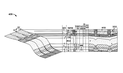
[0034] FIGS. 4A-4D are examples of a depositional system
facies template
including paleo-elevation and paleo-depth data. FIG 4A shows an example
graphical
map 405 that represents the actual geographical facies, including both primary
and
secondary facies. The black dots in FIG 4A represent paleo-elevations or paleo-
depths of the actual facies obtained, for example, using the logging tool 120
described
in FIG. 1. Each dot represents an observation that translates into depth (for
marine
rock) or elevation (for non-marine rock). Based on these elevations and
depths, using
interpolation and/or extrapolation, the map of the actual geologic profile can
be
generated, for example, by correlating the depths/elevations of the actual
facies to
CA 02839857 2013-12-18
WO 2013/015764
PCT/US2011/044933
corresponding theoretical facies represented by the selected template.
[0035] FIC. 4B is an example vertical section 410 that represents a
succession
of facies that are stacked vertically over time. The figure shows the vertical
arrangement of primary and secondary facies together with cross-cutting
facies. The
vertical section 410 is displayed adjacent to the user interface 300 in the
display
device. The arrangement of the facies can be displayed across multiple columns
(for
example, a first column 412, a second column 414, a third column 416, a fourth
column 418, a fifth column 420, a sixth column 422, and a seventh column 424).
The
first column 412 displays paleo-water depths for each facies. The second
column 414
displays the names of the facies. The fourth column 418 displays the names of
the
secondary facies and facies groups. The third column 416 is a graphical
depiction of
each primary facies displayed in the second column 414 and each secondary,
cross
cutting facies displayed in the fourth column 418. The fifth column 420, the
sixth
column 422, and the seventh column 424 display names for the secondary and
cross
cutting facies.
[0036] FIG 4C illustrates an example map 430 that shows a horizontal
profile
of the vertical arrangement generated in accordance with Walther's Law. FIG 4D
shows an example graphical map 435 representing an actual geologic
depositional
profile based on mapping the paleo-elevation or paleo-depth of actual facies
to a
selected theoretical geographical profile in accordance with Walther's Law.
The map
is created by positioning the maps of FIGS. 4A, 4B, and 4C adjacent to each
other.
[0037] FIG 5 is a flowchart of an exemplary process 500 for generating a
graphical map representing an actual depositional profile generated from a
theoretical
depositional profile. The process 500 can be implemented as computer program
instructions stored on a tangible computer-readable medium and executable by
data
processing apparatus. The process 500 generates multiple templates that each
describes a corresponding theoretical geologic depositional profile
representing an
arrangement of multiple theoretical geologic facies (step 505). The process
500
receives a selection describing a theoretical geologic depositional profile
(step 510).
For example, in some implementations, step 505 may include or be implemented
by
presenting in the user interface multiple unique templates including multiple
11
= CA 02839857 2013-12-18
WO 2013/015764
PCT/US2011/044933
theoretical geologic depositional systems. The received selection can be one
of the
multiple unique templates.
[0038]
In response to receiving the selection, the process 500 displays an
image of the theoretical geologic depositional profile in a user interface
(step 515).
The process 500 receives one or more paleo-elevations or paleo-depths relative
to sea
level of corresponding one or more actual facies in an actual geologic
depositional
profile (step 520). The process 500 maps the received paleo-elevations or
paleo-
depths of the actual facies to the theoretical geologic profile in accordance
with
Walther's Law (step 515). For example, in some implementations, step 515 may
include or be implemented by correlating the received paleo-elevations or
paleo-
depths of the actual facies to the theoretical geologic facies.
In some
implementations, the correlating can include or be implemented by determining
a
corresponding theoretical paleo-elevation or paleo-depth for a theoretical
facies in the
theoretical geologic profile that corresponds to the actual facies, for
example, by
interpolation or by extrapolation or both. In some implementations, step 515
may
include or be implemented by building a table having at least one of a row or
column
including descriptions of the multiple actual geologic facies and at least one
of a
corresponding row or column including the corresponding paleo-elevations or
paleo-
depths.
[0039]
The process 500 receives input to position one or more secondary
facies in the actual geologic depositional profile (step 530). For example, in
some
implementations, the one or more secondary facies can include at least one of
a river,
a submarine fan, or a channel. The one or more secondary facies can be
modeled, in
some implementations, based on object metrics included in the selected
template. The
process 500 generates a graphical map representing the actual geologic
depositional
profile based on the mapping and that includes one or more objects that
represent
corresponding one or more secondary facies (step 535). The process 500
displays the
generated graphical map in the user interface (step 540).
[0040]
Embodiments of the subject matter and the operations described in this
specification can be implemented in digital electronic circuitry, or in
computer
software, firmware, or hardware, including the structures disclosed in this
12
CA 02839857 2013-12-18
WO 2013/015764
PCT/US2011/044933
specification and their structural equivalents, or in combinations of one or
more of
them. Embodiments of the subject matter described in this specification can be
implemented as one or more computer programs, i.e., one or more modules of
computer program instructions, encoded on computer storage medium for
execution
by, or to control the operation of, data processing apparatus. Alternatively
or in
addition, the program instructions can be encoded on an artificially-generated
propagated signal, for example, a machine-generated electrical, optical, or
electromagnetic signal, that is generated to encode information for
transmission to
suitable receiver apparatus for execution by a data processing apparatus.
[0041] A computer storage medium can be, or be included in, a computer-
readable storage device, a computer-readable storage substrate, a random or
serial
access memory array or device, or a combination of one or more of them.
Moreover,
while a computer storage medium is not a propagated signal, a computer storage
medium can be a source or destination of computer program instructions encoded
in
an artificially-generated propagated signal. The computer storage medium can
also
be, or be included in, one or more separate physical components or media (for
example, multiple CDs, disks, or other storage devices).
[0042] The operations described in this specification can be implemented
as
operations performed by a data processing apparatus on data stored on one or
more
computer-readable storage devices or received from other sources.
[0043] The term "data processing apparatus" encompasses all kinds of
apparatus, devices, and machines for processing data, including by way of
example a
programmable processor, a computer, a system on a chip, or multiple ones, or
combinations, of the foregoing The apparatus can include special purpose logic
circuitry, for example, an FPGA (field programmable gate array) or an ASIC
(application-specific integrated circuit). The apparatus can also include, in
addition to
hardware, code that creates an execution environment for the computer program
in
question, for example, code that constitutes processor firmware, a protocol
stack, a
database management system, an operating system, a cross-platform runtime
environment, a virtual machine, or a combination of one or more of them. The
apparatus and execution environment can realize various different computing
model
13
= CA 02839857 2013-12-18
W02013/015764
PCT/US2011/044933
infrastructures, such as web services, distributed computing and grid
computing
infrastructures.
[0044] A computer program (also known as a program,
software, software
application, script, or code) can be written in any form of programming
language,
including compiled or interpreted languages, declarative or procedural
languages, and
it can be deployed in any form, including as a stand-alone program or as a
module,
component, subroutine, object, or other unit suitable for use in a computing
environment. A computer program may, but need not, correspond to a file in a
file
system. A program can be stored in a portion of a file that holds other
programs or
data (for example, one or more scripts stored in a markup language document),
in a
single file dedicated to the program in question, or in multiple coordinated
files (for
example, files that store one or more modules, sub-programs, or portions of
code). A
computer program can be deployed to be executed on one computer or on multiple
computers that are located at one site or distributed across multiple sites
and
interconnected by a communication network.
[0045] The processes and logic flows described in this
specification can be
performed by one or more programmable processors executing one or more
computer
programs to perform actions by operating on input data and generating output.
The
processes and logic flows can also be performed by, and apparatus can also be
implemented as, special purpose logic circuitry, for example, an FPGA (field
programmable gate array) or an ASIC (application-specific integrated circuit).
[0046] Processors suitable for the execution of a computer
program include,
by way of example, both general and special purpose microprocessors, and any
one or
more processors of any kind of digital computer. Generally, a processor will
receive
instructions and data from a read-only memory or a random access memory or
both.
The essential elements of a computer are a processor for performing actions in
accordance with instructions and one or more memory devices for storing
instructions
and data. Generally, a computer will also include, or be operatively coupled
to
receive data from or transfer data to, or both, one or more mass storage
devices for
storing data, for example, magnetic, magneto-optical disks, or optical disks.
However, a computer need not have such devices. Moreover, a computer can be
14
CA 02839857 2013-12-18
WO 2013/015764
PCT/US2011/044933
embedded in another device, for example, a mobile telephone, a personal
digital
assistant (PDA), a mobile audio or video player, a game console, a Global
Positioning
System (GPS) receiver, or a portable storage device (for example, a universal
serial
bus (USB) flash drive), to name just a few. Devices suitable for storing
computer
program instructions and data include all forms of non-volatile memory, media
and
memory devices, including by way of example semiconductor memory devices, for
example, EPROM, EEPROM, and flash memory devices; magnetic disks, for
example, internal hard disks or removable disks; magneto-optical disks; and
CD-ROM and DVD-ROM disks. The processor and the memory can be
supplemented by, or incorporated in, special purpose logic circuitry.
[0047] To provide for interaction with a user, embodiments of the
subject
matter described in this specification can be implemented on a computer having
a
display device, for example, a CRT (cathode ray tube) or LCD (liquid crystal
display)
monitor, for displaying information to the user. All or portions of the
display device
can include a touch screen or any touch-sensitive user interface. The computer
can
also include a keyboard and a pointing device, for example, a mouse or a
trackball or
touch pad, by which the user can provide input to the computer. Other kinds of
devices can be used to provide for interaction with a user as well; for
example,
feedback provided to the user can be any form of sensory feedback, for
example,
visual feedback, auditory feedback, or tactile feedback; and input from the
user can be
received in any form, including acoustic, speech, or tactile input. In
addition, a
computer can interact with a user by sending documents to and receiving
documents
from a device that is used by the user; for example, by sending web pages to a
web
browser on a user's client device in response to requests received from the
web
browser.
[0048] While this specification contains many specific implementation
details,
these should not be construed as limitations on the scope of any inventions or
of what
may be claimed, but rather as descriptions of features specific to particular
embodiments of particular inventions. Certain features that are described in
this
specification in the context of separate embodiments can also be implemented
in
combination in a single embodiment. Conversely, various features that are
described
= CA 02839857 2013-12-18
W02013/015764
PCT/US2011/044933
in the context of a single embodiment can also be implemented in multiple
embodiments separately or in any suitable subcombination. Moreover, although
features may be described above as acting in certain combinations and even
initially
claimed as such, one or more features from a claimed combination can in some
cases
be excised from the combination, and the claimed combination may be directed
to a
subcombination or variation of a subcombination.
[0049]
Similarly, while operations are depicted in the drawings in a particular
order, this should not be understood as requiring that such operations be
performed in
the particular order shown or in sequential order, or that all illustrated
operations be
performed, to achieve desirable results. In certain circumstances,
multitasking and
parallel processing may be advantageous. Moreover, the separation of various
system
components in the embodiments described above should not be understood as
requiring such separation in all embodiments, and it should be understood that
the
described program components and systems can generally be integrated together
in a
single software product or packaged into multiple software products.
[0050]
Thus, particular embodiments of the subject matter have been
described. Other embodiments are within the scope of the following claims. In
some
cases, the actions recited in the claims can be performed in a different order
and still
achieve desirable results. In addition, the processes depicted in the
accompanying
figures do not necessarily require the particular order shown, or sequential
order, to
achieve desirable results. For example, other methods described herein besides
those,
or in addition to those, illustrated in FIG. 5 can be performed. Further, the
illustrated
steps of process 500 can be performed in different orders, either concurrently
or
serially. Further, steps can be performed in addition to those illustrated in
process
500, and some steps illustrated in process 500 can be omitted without
deviating from
the present disclosure.
In certain implementations, multitasking and parallel
processing may be advantageous. Accordingly, other implementations are within
the
scope of the following claims.
16