Note: Descriptions are shown in the official language in which they were submitted.
CA 02840555 2015-10-23
64267-1839
SPECTRUM SHARING BETWEEN AN AIRCRAFT-BASED AIR-TO-GROUND
COMMUNICATION SYSTEM AND EXISTING GEOSTATIONARY SATELLITE
SERVICES
[0001]
FIELD OF THE INVENTION
[0002] This invention relates to Air-To-Ground (ATG)
communications and, in particular, to a communication system that provides
communication
devices, which are served by a communication network located on an aircraft,
with high speed
Air-To-Ground communications service by the reuse of the radio frequency
spectrum
presently used by Geostationary Satellite Services extant in the volume of
space in which the
aircraft operates.
BACKGROUND OF THE INVENTION
[0003] It is a problem in the field of Air-To-Ground
(ATG)
communications, such as between aircraft and ATG ground stations, to provide
sufficient
bandwidth to carry the communications between the communication devices, which
are
served by a communication network (wired or wireless) located on the aircraft,
and ATG
ground stations which are connected to terrestrial communication networks. The
collection of
ATG ground stations used for this purpose implement a traditional cellular
network, with each
ATG ground station consisting of a "cell site." There are limited choices of
spectrum which
are available for this purpose, which
1
CA 02840555 2013-12-24
WO 2013/003382 PCT/US2012/044266
choices are also limited by the ability to implement the corresponding radio
frequency antennas on
the aircraft.
[0004] The typical ATG cellular communications network consists of a
number of
terrestrial (ground) ATG base stations, each of which provides a radio
frequency coverage area in a
predetermined volume of space, radially arranged around the cell site
transmitting and receiving
antennas. This terrestrial base station uses antenna patterns which are less
sensitive to the reception
of ground-originating or ground-reflected signals and which antenna patterns
are primarily focused
on the area between the horizon and zenith. The terrestrial base stations are
geographically
distributed, generally following a typical cellular communications network
layout. Terrestrial base
stations can also be co-located near airports to enable network coverage when
aircraft are on the
ground; in this case, the antenna patterns are optimized for terrestrially-
located aircraft. The
boundaries of the coverage area of each terrestrial base station are
substantially contiguous with that
of neighboring sites so that the composite coverage of all of the terrestrial
base stations in the ATG
cellular communications network generally provides coverage over the targeted
area. Terrestrial
base stations may provide either a single omni-cell of coverage using
transceiver(s) associated with a
single transmit-and-receive antenna system or multiple sectors within the area
of coverage of the
site, each with associated transceivers and the associated transmit-and-
receive antennas. The
advantage of the latter arrangement, with multiple sectors per terrestrial
base station, is to allow
provision of increased call and data traffic handling capacity in the coverage
area of that terrestrial
base station.
[0005] The present radio frequency spectrum which is available for
this purpose
limits the total available traffic handling capacity in any single cell. Thus,
the radio frequency
communications link between the aircraft and the terrestrial base stations of
the ATG cellular
communications network has limited capacity and, as passengers utilize the
aircraft network for
Internet browsing and broadband file downloads, the channel capacity becomes
exhausted before
the demand is served in its entirety. More advantageous spectrum choices are
presently unavailable,
because they are dedicated for pre-existing uses, such as satellite
communications.
BRIEF SUMMARY OF THE INVENTION
[0006] The above-described problems are solved and a technical
advance achieved
in the field by the present Spectrum Sharing Between An Aircraft-Based Air-To-
Ground
Communication System And Existing Geostationary Satellite Services (termed
"Spectrum Sharing
2
CA 02840555 2015-10-23
64267-1839
=
System" herein) which implements spectrum reuse between aircraft-based Air-To-
Ground
(ATG) communication systems and Geostationary Satellite Service systems. This
is
accomplished by managing the radio frequency transmissions in the volume of
space in which
the aircraft operates, with interference between the Spectrum Sharing System
and the
Geostationary Satellite Service system being reduced by implementing reversed
uplink and
downlink radio frequency paths in the common spectrum. The Spectrum Sharing
System also
avoids interfering with Geostationary Satellite Services' earth stations which
are pointed
towards the satellites' orbital arc by relying upon a combination of the earth
stations' highly
directive antenna patterns and the Spectrum Sharing System ground station
antenna pattern,
and to avoid interfering with satellites in their orbital arc by assuring that
power levels
radiated in that direction by the Spectrum Sharing System ground stations are
below the level
that would create interference.
100071 The present Spectrum Sharing System thereby
provides
increased bandwidth to provide communication devices, which are served by a
communication network located on an aircraft, with high speed Air-To-Ground
communications service, since the selected frequencies provide greater
bandwidth than those
presently in use in ATG communications or can be used to supplement the ATG
frequencies
presently in use. Interference between the Spectrum Sharing System and the
Geostationary
Satellite Service system is reduced by implementing reversed uplink and
downlink radio
frequency paths in the common spectrum. Furthermore, one of the conditions for
mitigation of
interference between the two systems is that the transmission of the Spectrum
Sharing System
ground station is outside of the main beams of the Geostationary Satellite
Service earth station
antennas. This means that, in the Northern Hemisphere, the Spectrum Sharing
System ground
station needs to be transmitting in a southerly direction into the back lobe
of the earth station
antenna of the Geostationary Satellite Service system, which is transmitting
in a southerly
direction toward the Geostationary satellites; and in the Southern Hemisphere,
the Spectrum
Sharing System ground station needs to be transmitting in the northerly
direction into the back
lobe of the earth station antenna of the Geostationary Satellite Service
system, which is
transmitting in a northerly direction toward the Geostationary satellites.
3
CA 02840555 2015-10-23
64267-1839
=
[0007a] According to an aspect of the present
disclosure, there is
provided a system for providing wireless communication services to
communication devices
that are located in an aircraft that is operational in a selected coverage
area, wherein at least
one geostationary satellite communication system is operational in the
selected coverage area
and uses a plurality of earth stations, each of which transmits a first beam
that is directed
skyward, in a direction toward the equator of the earth, and each of which
uses the first beam
to transmit radio frequency signals to a satellite at a first radio frequency
and receive radio
frequency signals from the satellite at a second radio frequency, the system
comprising: at
least one ground station for creating a radio frequency coverage area that
provides radio
frequency links to aircraft that are operational in the radio frequency
coverage area,
comprising: a transmitter that generates a radio frequency signal at the
second radio frequency
for transmission to the aircraft; and an antenna that produces a second beam
of the radio
frequency signal generated at the second radio frequency, wherein the second
beam is broader
in extent that than the first beam and is directed skyward in a direction
toward the equator of
the earth such that the second beam substantially fails to radiate into any
first beam
transmitted by the earth stations of the geostationary satellite communication
system.
[0007131 There is also provided a method for providing
wireless
communication services to wireless communication devices that are located in
an aircraft that
is operational in a selected coverage area, wherein at least one geostationary
satellite
communication system is operational in the selected coverage area and uses a
plurality of
earth stations, each of which transmits a first beam that is directed skyward,
in a direction
toward the equator of the earth, and each of which uses the first beam to
transmit radio
frequency signals to a satellite at a first radio frequency and receive radio
frequency signals
from the satellite at a second radio frequency, the method comprising:
operating at least one
ground station for creating a radio frequency coverage area that provides
radio frequency links
to aircraft that are operational in the radio frequency coverage area,
comprising: generating a
radio frequency signal at the second radio frequency for transmission to the
aircraft; and
operating an antenna to produce a second beam of the radio frequency signal
generated at the
second radio frequency, wherein the second beam is broader in extent than the
first beam and
is directed skyward in a direction toward the equator of the earth such that
the second beam
3a
CA 02840555 2015-10-23
= 64267-1839
substantially fails to radiate into any first beam transmitted by the earth
stations of the
geostationary satellite communication system.
BRIEF DESCRIPTION OF THE DRAWINGS
[0008]
Figure 1 illustrates a graphic representation of the radio
frequency spectrum sharing plan, between Air-To-Ground systems and satellite
based
systems, which is implemented by the present Spectrum Sharing System;
3b
CA 02840555 2013-12-24
WO 2013/003382 PCT/US2012/044266
[0009] Figure 2 illustrates, in graphical form, the limit on the
aircraft transmit power
spectral density in dBm [the power ratio in decibels (dB) of the measured
power referenced to one
milliwatt (mW)] per 1 MHz (megahertz) of allocated spectrum for the present
Spectrum Sharing
System, where the power is charted as a function of number of aircraft and
desired level of
protection for the geo-stationary satellite receivers;
[0010] Figure 3 illustrates, in graphical form, the portion of a
geostationary arc
visible from the location of an earth station;
[0011] Figure 4 illustrates, in graphical form, the required
conditions for Air-To-
Ground transmission outside of the main lobe of earth station antennas;
[0012] Figure 5 illustrates the orientation of Shared Spectrum System
ground
stations and aircraft in relation to Geostationary Satellite Service earth
stations; and
[0013] Figure 6 illustrates the antenna pointing angle from the
Geostationary
Satellite Service system is in a southerly direction, ranging from a low
azimuth angle for
Geostationary Satellite Service earth stations in the northern extent of the
coverage area to a high
azimuth angle for Geostationary Satellite Service earth stations in the
southern extent of the
coverage area.
DETAILED DESCRIPTION OF THE INVENTION
[0014] As shown in Figure 5, a satellite 501 in a geostationary orbit
appears to be in
a fixed position to an earth-based observer. A geostationary satellite 501
revolves around the earth
at a constant speed once per day over the equator, thus matching the speed of
rotation of the earth
and appearing stationary relative to any point on the earth's surface. The
geostationary orbit is
useful for communications applications because earth station antennas 511,
512, which must be
directed toward satellite 501, can operate effectively without the need for
expensive equipment to
track the satellite's motion. Since geostationary satellites are constrained
to operate above the
equator, a geostationary satellite appears low on the horizon to the earth
station antennas when i)
earth stations are near the easternmost or westernmost coverage limits of a
satellite; or ii) when
earth stations are at high latitudes. For most earth stations operating within
the continental US, the
geostationary satellite is 20 to 50 above the horizon; and the beam width of
antennas is sufficiently
narrow (on the order of 2 or less) to avoid ground reflections and
interference between satellites.
4
CA 02840555 2013-12-24
WO 2013/003382 PCT/US2012/044266
Radio Frequency Spectrum Sharing Plan
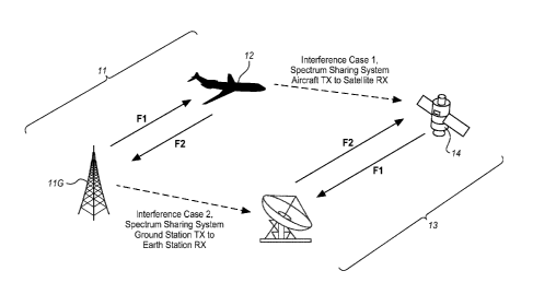
[0015] Figure 1 illustrates a graphic representation of an illustrative
embodiment of
the radio frequency spectrum sharing plan, between the present Spectrum
Sharing System 11 and
Geostationary Satellite Service system 13, to provide communications services
to communication
devices (not shown) which are located onboard aircraft 12. In the present
Spectrum Sharing
System 11, uplink transmissions from Spectrum Sharing System ground stations
11G to aircraft 12
use an existing satellite downlink frequency band Fl (and optionally the
existing satellite uplink
frequency band F2 and optionally the existing ATG frequency band), while
downlink transmissions
from aircraft 12 to Spectrum Sharing System ground stations 11G use an
existing satellite uplink
frequency band F2 (and optionally the existing ATG frequency band). The two
systems (Spectrum
Sharing System 11 and Geostationary Satellite Service system 13) are co-
spectrum, and there exists a
possibility for mutual interference which may be in both the uplink and
downlink directions. There
are four possibilities for interference:
1. From the Spectrum Sharing System Aircraft transmitter (not shown, but
located in aircraft 12) to the Geostationary Satellite Service system
satellite receiver;
2. From the Spectrum Sharing System ground station transmitter to the
Geostationary Satellite Service system earth station receiver;
3. From the Geostationary Satellite Service system earth station
transmitter to
the Spectrum Sharing System ground station receiver; and
4. From the Geostationary Satellite Service system satellite transmitter to
the
Spectrum Sharing System Aircraft receiver (not shown, but located in aircraft
12).
[0016] Interference from the Spectrum Sharing System 11 to the
Geostationary
Satellite Service system 13 is more significant than the interference in the
opposite direction due to
the differences in signal power and the highly directional antenna patterns
used in the Geostationary
Satellite Service system 13. There are two primary cases of this interference
between Spectrum
Sharing System 11 and Geostationary Satellite Service system 13 as is
illustrated in Figure 1. Case 1
illustrated in Figure 1 is interference from the Spectrum Sharing System
aircraft transmitter at
frequency F2 to the satellite receiver 13 of the Geostationary Satellite
Service system 13, and Case 2
illustrated in Figure 1 is interference from Spectrum Sharing System ground
station 11G transmitter
at frequency Fl to the Geostationary Satellite Services earth station 13G
receiver.
CA 02840555 2013-12-24
WO 2013/003382 PCT/US2012/044266
Interference Between Spectrum Sharing System And The Geostationary Satellite
Service
[0017] The interference in Case 1, where the aircraft radio frequency
transmissions
on frequency F2 interfere with the satellite received radio frequency signals,
is relatively low. On the
ground, Geostationary Satellite Service signals on frequency Fl are extremely
weak unless received
by an accurately pointed high gain antenna, such as that used by the earth
station 13G of the
Geostationary Satellite Service system 13. Geostationary Satellite Service
earth station antennas are
usually high gain antennas that radiate only through a very narrow beam
upwardly directed toward
the satellite 14 with which the Geostationary Satellite Service earth station
13G communicates.
With a minimum precaution in the location of the Spectrum Sharing System
ground stations 11G,
this interference can be easily avoided.
[0018] Figure 5 illustrates the orientation (but not drawn to scale) of a
plurality of
Shared Spectrum System ground stations 531-533 (which are but a few of those
that are necessary
to provide complete coverage of the service area which consists of the region
of space 500 between
the earth surface and the maximum altitude at which the aircraft are
operational) and aircraft 551-
553 in relation to Geostationary Satellite Service geo-synchronous satellites
500 and earth stations
511-512. As can be seen from this figure, the antenna beam 521-522 for the
Geostationary Satellite
Service earth station antennas 511-512 is narrow in extent and upwardly
directed at the orbital arc of
the selected geosynchronous satellites 500 located above the equator. The
antenna pointing angle
from the Geostationary Satellite Service system 13 is in a southerly
direction, ranging from a low
azimuth angle for earth stations 512 in the northern extent of the coverage
area to a high azimuth
angle for earth stations 511 in the southern extent of the coverage area, as
illustrated in Figure 6. In
contrast, the Shared Spectrum System antenna beams 541-543, while also
upwardly pointing and
generally pointing towards just above the horizon, are broad in extent. The
primary interference
mode constitutes the Shared Spectrum System antenna beams 541-543 being
received by the
Geostationary Satellite Service earth station 511-512 antennas. Therefore,
radio frequency
transmission management requires:
= "Southerly" pointing of the Spectrum Sharing System ground station
antennas for
signals at low elevation angles, with any northern facing signals at angles
well above
the horizon. This way, the Spectrum Sharing System ground station transmission
is
outside of the main beams for the Fixed Satellite Service earth station
receiver
antennas. The limits of the coverage of the Spectrum Sharing System antennas
at
6
CA 02840555 2013-12-24
WO 2013/003382 PCT/US2012/044266
any particular latitude are governed by the range of azimuth angles to the
orbital arc,
as illustrated in Figure 5, with a small additional allowance for the maximum
beamwidth of the earth station receive antennas.
= To maintain low power spectral density on the Spectrum Sharing System
ground
station transmission, the signal may need to be spread over a large portion of
spectrum. Fortunately, several satellites bands provide hundreds of MHz of
spectrum, which is sufficient to reduce spectral density to sufficiently low
levels
while maintaining high data rates from the ground to the aircraft.
[0019] From the interference mitigation standpoint, use of antennas
with highly
discriminating patterns on both ends of the Spectrum Sharing System spectrum
would be highly
beneficial. Additional techniques that may be used for interference mitigation
are:
1. Placement of the Spectrum Sharing System ground stations;
2. Antenna patterns of the Spectrum Sharing System ground stations,
including
beam forming and beam steering;
3. Signal spreading;
4. Power control; and
5. Active interference cancelation in case of beam steering.
Evaluation Of The Ground Station Transmission To Earth Station Receiver
[0020] As an example, when viewed from the continental US, the orbit
of a
geostationary satellite is in a southerly direction. All of the Geostationary
Satellite Service earth
station antennas, therefore, are pointing towards the south. Depending on the
latitude of the earth
station, only a portion of the geostationary arc of the satellite is visible.
The situation is illustrated in
Figure 3. For any given geographical location of the earth station, there are
two longitudes that limit
the visible portion of the geostationary arc, which are labeled as /E, and /Ty
. Therefore, the
antenna of the earth station always points to some location on the visible
portion of this
geostationary arc. As the latitude of the earth station increases towards
north, the portion of the
visible arc becomes smaller. For earth stations that are above ¨80 north, the
geostationary orbit is
not visible.
7
CA 02840555 2013-12-24
WO 2013/003382 PCT/US2012/044266
[0021] Consider an earth station at the latitude/longitude location
given by a pair of
coordinates (LEs , 'ES). Coordinate L Es is the earth station latitude, while
/Es is the earth station
longitude. Using simple geometry, one can easily demonstrate the following
relationships:
(
-1 re
1 E = 1 Es ¨ COS (1)
rs cos(L )
ES
r
1 = 1 + cos-1 e
W ES (2)
rs cos(L )
ES
A = y
ZE (3)
A = 360 ¨ )7
zw (4)
where
(
sn5L
( (
cos
i(Es .5LEs
Y = tan-1 ________________________ + tan
tan(1/E ¨ L Es =1)COS(0 5LES)
tan(1/E LES 1)sin(0.5LES )) (5)
[0022] Quantities AZE and Azw are azimuth angles from the earth
station
towards far east and far west points on the visible portion of the
geostationary arc. These two
angles provide maximum theoretical range of directions where the earth station
antenna may point.
In practical scenarios, the range is always narrower than what is provided by
equations (3) and (4).
[0023] As an illustration, Table 1 provides values for 1E 1w, A ZE
and Azw
for two earth stations. The first one is located in Melbourne, Florida, while
the second one is in
Chicago, Illinois. In the Melbourne area, the azimuth for the earth station
antennas must fall within
the range of from 95.51 to 273.49 . For the Chicago earth stations, the
pointing range extends
from 99.33 to 269.67 .
Melbourne, Florida Chicago, Illinois
Latitude (deg) 28.0628 41.9978
Longitude (deg) 80.6231 87.6831
8
CA 02840555 2013-12-24
WO 2013/003382 PCT/US2012/044266
/E (deg, W) 2.21 11.48
1
(deg,
159.04 163.89 W W)
Length of the arc (deg) 78.42 76.21
Azimuth to far east point A
ZE (deg) 95.51 99.33
Azimuth to far west point Azw (deg) 273.49 269.67
Table 1. Geostationary Satellite visible from two locations in the continental
US
[0024] Referring back to the radio frequency reuse scenario presented
in Figure 1, it
is evident that one of the conditions for mitigation of interference between
the two systems is that
the radio frequency transmission of the Spectrum Sharing System ground station
is outside of the
main beams of the earth station antennas. This means that the Spectrum Sharing
System ground
station needs to be transmitting towards the south within the range of azimuth
angles as specified by
equations (3) and (4) (with small additional reductions as required to avoid
the beamwidth of the
earth station antennas). This way, the signal from the Spectrum Sharing System
ground stations is
in the back lobe of the Geostationary Satellite Service earth station antenna.
Figure 4 illustrates, in
graphical form, the required conditions for the Spectrum Sharing System uplink
transmission
outside of the main lobe of the Geostationary Satellite Service earth station
antennas.
[0025] The power spectrum density of the interference from the
Spectrum Sharing
System ground station transmission at the back lobe of the earth station
antenna may be calculated
as:
S/ = SATG GATG(9)¨ PLdB = EiRP/ W PLdB (6)
[0026] One may assume that the impact of the Spectrum Sharing System
ground
station transmission becomes negligible when the Si in equation (6) falls
below the noise floor by
a certain threshold. That is:
EiRP/W[dBm/MHz] 10 log(kT) + PLdB ¨ TdB +90 (7)
9
CA 02840555 2013-12-24
WO 2013/003382
PCT/US2012/044266
[0027] Table 2 is generated using equation (7) and assuming TdB = 3dB
. The
table specifies the maximum Effective Isotropic Radiated Power (EiRP) per MHz
allowed for the
ground-to-air transmission. The use of the table is illustrated through a
following simple example.
[0028] Consider a Spectrum Sharing System ground station in a
location that is
20 km away from the closest Geostationary Satellite Service earth station. The
allowed ground
station power spectrum density is 23dBm/MHz (i.e., 200mW/MHz). Assuming the
Spectrum
Sharing System uplink operation is 20MHz of the spectrum, the overall EiRP is
36.04dBm (4W).
EiRP/W
d [km] Path loss [dB] EiRP [dBm] EiRP [W]
[dBm/MHz]
1 113.99 -2.99 10.02 0.01
127.97 10.99 24.00 0.25
133.99 17.01 30.02 1.00
137.51 20.53 33.54 2.26
140.01 23.03 36.04 4.02
141.95 24.97 37.98 6.28
143.53 26.55 39.56 9.04
144.87 27.89 40.90 12.31
146.03 29.05 42.06 16.08
Table 2. Limit on the uplink EiRP in dBm/MHz(*)
(*) The EiRP values are calculated assuming 20MHz channel
[0029] Based on Table 2, the allowed power spectral density for
Spectrum Sharing
System uplink transmission is relatively low. The table assumes that there is
no additional
attenuation from the back lobe of the earth station antennas. Also, the table
is derived assuming no
discrimination from the Spectrum Sharing System ground station antenna. In the
practical
implementation, these additional factors should be evaluated on the basis of
required data rates and
Spectrum Sharing System cell site link budgets.
[0030] Figure 4 illustrates, in graphical form, the required
conditions for Spectrum
Sharing System uplink transmissions to be outside of the main lobe of the
Geostationary Satellite
Service earth station antennas. In particular, Geostationary Satellite Service
earth stations 421-436
CA 02840555 2013-12-24
WO 2013/003382 PCT/US2012/044266
are shown with their respective antenna beams pointing toward satellites 411-
414 of Figure 4. For
the Spectrum Sharing System ground stations 401-408 not to transmit into the
receiver antennas at
the Geostationary Satellite Service earth stations 421-436, their antenna
beams should be oriented as
shown in Figure 4 to prevent the near-earth surface portion of the beam (i.e.
the southern portion
of the beam) from being received by the main lobe of the Geostationary
Satellite Service earth
stations 421-436. This is not unduly limiting, since the antenna pattern
generated by the Shared
Spectrum System antennas are broad three-dimensional shapes and can be managed
to avoid the
near-ground portions of the pattern in the direction of any nearby
Geostationary Satellite Service
earth stations 421-436 that are generally north of the ground stations. This
does not affect the
upwardly pointing segment of the antenna pattern from the Shared Spectrum
System antennas.
Evaluation Of The Interference From Aircraft-Based Transmissions To The
Satellite
Receiver
[0031] From the standpoint of the satellite receiver, the energy
transmitted from the
Spectrum Sharing System aircraft adds to the noise temperature of the
satellite receiver antenna.
The satellite receiver antenna is pointing toward the earth, which has a
nominal noise temperature
of 290K. Therefore, as long as the power spectrum density produced by the
Spectrum Sharing
System aircraft transmission is significantly smaller than the power spectrum
density of the thermal
noise generated by the earth's radiation, the impact of the spectrum sharing
is negligible. The power
spectral density of the Spectrum Sharing System aircraft transmission depends
on the EiRP of the
aircraft, the bandwidth of the Spectrum Sharing System service, and the number
of aircraft that are
operating at any given time within the main beam of the satellite antenna.
[0032] The power spectral density of the thermal noise received by
the satellite
antenna may be calculated as:
No = kTE = 1.38 x 1 0-23 W
290K = 4 x 10-21 ¨204dBW/Hz (8)
Hz = K Hz
[0033] The power spectral density of the interference to the
satellite receiver that is
caused by the transmission from the Spectrum Sharing System aircraft may be
estimated as:
n.SA
NA= ______________________________________ (9)
FSPL
11
CA 02840555 2013-12-24
WO 2013/003382 PCT/US2012/044266
[0034] Where n is the number of aircraft within the main beam of the
satellite
antenna, SA is the radiated power spectral density of a single aircraft and
the Free Space Path Loss
(FSPL) in the linear domain.
[0035] By converting equation (9) into log domain, one obtains:
N A[dBW I HZ] = 10log(n)+ SA[dB W I HZ] ¨ FSPLdB (10)
[0036] Let TdB be a threshold value that specifies the difference
between the
power spectral densities of thermal noise and the interference caused by
operating Spectrum Sharing
System aircraft. In other words:
TdB = N0 [c1BWIHz]¨ NA[CIBW I HZ]
(11)
[0037] By combining equations (10) and (11), one obtains the limit on
transmit
power spectrum density of a single aircraft:
SA [CIBM/MHZ] = N0 [dBW1Hz]+ FSPLdB ¨10log(n)¨ T dB +90 (12)
[0038] Equation (12) is used to generate the family of curves
presented in Figure 2
which illustrates, in graphical form, the limit on the aircraft transmit power
spectral density in dBm
per 1 MHz of allocated spectrum for the present Spectrum Sharing System.
Use Of The Curves In Figure 21s Illustrated Through A Simple Example
[0039] Consider a case when the Spectrum Sharing System is operating
on 1,000
aircraft within the volume of space covered by the satellite receiver antenna.
Assume that the
T 20dB
protection threshold is set to add = , and
that all of the aircraft are in the main beam
of the satellite receiver antenna. According to Figure 2, the transmission of
each aircraft has a
power spectral density limit of 43dBm/MH7 (20 Watts in 1MH7 bandwidth).
[0040] One point to note is that the presented analysis is on the
worst case side.
There are additional factors that would reduce the interference from the
Spectrum Sharing System
aircraft to the satellite receiver. Some of those factors, which were
neglected in the analysis, may be
listed as follows:
12
CA 02840555 2013-12-24
WO 2013/003382 PCT/US2012/044266
1. The analysis assumes that all of the aircraft are transmitting with the
maximum power. In operational scenarios, the transmission of the
aircraft is under power control and is always below the maximum value.
2. The analysis assumes that the EiRP of the aircraft is the same towards
the
serving cells on the ground and towards the satellite antenna. In practical
implementation, it is reasonable to assume that the aircraft antenna
directs most of the energy towards the ground, and the amount of
radiation towards the sky would be significantly lower.
Only Free Space Path Losses are considered. In a practical scenario,
additional losses due to
atmospheric phenomena add to the attenuation of the aircraft-generated signal.
Summary
[0041] Spectrum sharing between the Spectrum Sharing System and the
Geostationary Satellite Service is possible. However, to make the sharing
technically feasible, careful
management of the interference between the Spectrum Sharing System ground
station and the
Geostationary Satellite Service earth station receiver side is required.
13