Note: Descriptions are shown in the official language in which they were submitted.
CA 02841491 2014-02-03
41.
SYSTEM, PROGRAM PRODUCT, AND METHOD FOR DRILLING
RIG ACTIVITY ACCOUNTING AND VISUALIZATION
BACKGROUND
Field of the Invention
[0002j This invention relates in general to drilling rig data
management and, in
particular, to an activity accounting process and interactive data
presentation system
which utilizes Geospatial Information System Technology.
Description of the Prior Art
[0003j The assignee of the present invention, publishes extensive
data on global rig
activity known as "rig counts." Such data can be categorized in any variety of
ways, such
as by region (e.g., country, state, county, etc.), type of activity (e.g.,
drilling for oil or gas,
geothermal, etc.), location (e.g., land or offshore), well type (e.g.
development,
exploration, or infill), or by well trajectory (e.g., directional, horizontal,
or vertical).
Information consumers use this data as a basis for forecasting business
activities and
investment decisions. Examples of information consumers include securities
analysts,
drilling company analysts, oilfield service company analysts, operator
analysts, and
government agencies. Recognized by Applicants is that such information
consumers
often view investments opportunities by basin and geological provinces, and
thus, would
find useful such data if compiled and reported by basin or geological
province. Also
recognized is the need for types of information beyond that provided by
traditional "rig
counts."
[0004] Rig counts have been historically published at fixed times.
For example,
international rig counts are published on a monthly basis, while publishing
United States
rig counts on a weekly basis. Recognized by Applicants is the need for such
information
1
CA 02841491 2014-02-03
et
supplied using different criteria such as, for example, historical (to provide
trend
information), at fixed calendar intervals, event driven (e.g., in response to
a local or a
global event or change in conditions), and on demand (e.g., just-in-time) such
as at a
critical stage in an investment decision-making process_
[0005] Also, historically, rig counts have been published ("pushed") in
a "one-format
fits all" presentation style. Recognized by the Applicants is the need for a
new process
which will allow individual users to tailor the type, amount, and format of
the data that
they want to "pull" when they wish to have an update and through which type of
channel.
[0006] There are many disadvantages to traditional methods of rig
counting. For
example, historically, the rig counts have been "noisy" (or uncertain) due to
a number of
factors. First, for example, due to the remoteness of rigs and weather
conditions, there
are difficulties in validating actual rig activity in the field. Second, it is
difficult to
capture and transmit rig data from some locations. Also, continuous changes in
the
location of rigs, changes in the population of rigs due to newly constructed
rigs, de-
commissioning, and transfers between operators, etc. provide even more
difficulties in
this area. In addition, historically, rig counts have been a by-product of
business activity
service providers and not the result of a formal, dedicated business process.
Recognized
is the need for a new business process that eliminates or mitigates "noise"
that allows a
rig count information service provider to estimate the level of uncertainty or
"noise" in
the rig counts, and that provides quality assurance of the rig counts prior to
provision to
end-users (e.g., information consumers).
[0007] There are also disadvantages in the traditional methods of
presenting the rig
counts. Historically, end-users of the rig counts access the information on-
line as text
report or spreadsheets. This form of presentation has several drawbacks. For
example,
the end-users must re-enter the data into their proprietary analysis tools to
derive useful
interpretations, the data is presented statically, and, although the data has
a critical
geospatial dimension (e.g., location of oil and gas bearing formations,
location of rigs,
location of geopolitical boundaries, etc.), the data fails to reflect this
information directly.
Recognized by Applicants is the need to allow for layering and visualization
of activity
data over digital maps, and querying by means of interactions with graphical
presentations of the data, which can enable new forms of interpretation by
supporting the
2
visualization of trends through, e.g., visual "playback" of trend data that
will provide
insights on individual rig behavior (e.g., rig movements over a period of
time, depths
drilled overtime) or rig herd behavior (e.g., movements of types over periods
of time).
[0008] Recent advances in information technology enable a fundamentally new
approach to the capture, management, and presentation of rig activity
information. Such
advances include interactive graphic interfaces, database systems, the
Internet, portal
technology, geospatial information system technology, and portable/wireless
telecommunication devices. Accordingly, the applicants recognize the need to
overcome these before mentioned disadvantages by integrating and extending
these
technological advances as addressed by embodiments of the present invention.
SUMMARY OF THE INVENTION
[0009] In view of the foregoing, embodiments of the present invention
advantageously
provide systems, program product, and methods which track, record, and manage
drilling rig activity data to present the data in a high-quality graphical
user interface
using, e.g., geospatial models. Embodiments of the present invention also
include
dedicated systems to process rig data from various information providers and
personnel,
track and maintain rig activity information in a redundant system of record,
and
integrate this information and other types of information (e.g., economic,
political, etc.)
to present the information in an interactive geospatial model. Embodiments of
the
present invention also allows for a "push" and "pull" mode, as well as profile-
based
personalization of information, which dictates what information is presented,
how that
information is presented, and how often. Embodiments of the present invention
advantageously provide a system, program product, and method which utilizes a
combination of new processes to provide increased data quality in rig activity
accounting and data verification, as well as increased user control and user-
friendly
interaction in rig activity data presentation, which allows users of such to
access the rig
activity information via a telecommunication device and query the system to
receive the
data based upon a variety of personalized attributes.
[0010] Accordingly, in one aspect there is provided a system to monitor
drilling rig
activity and to provide and manage drilling rig information, the system
comprises a
drilling rig information management server to provide user access to drilling
rig
information, the drilling rig information management server including a
processor and
3
CA 2841491 2018-07-06
memory in communication with the processor; and drilling rig infoimation
management
program product stored in the memory of the drilling rig information
management
server and including instructions that when executed by the server cause the
server to
perform the operations of: receiving from one or more communication devices a
user
selection of a geospatial location defined by a gcospatial location attribute;
retrieving
drilling rig location data from a database responsive to receiving the user
selection of
the geospatial location defined by the geospatial location attribute;
accessing digital
mapping data and communicating the digital mapping data to the one or more
communication devices to display a digital map of at least portions of a
geospatial
location defined by the geospatial location attribute responsive to the user
selected
geospatial location attribute on the one or more communication devices;
communicating
time-sequenced drilling rig activity evolution data to the one or more
communication
devices to graphically display a time-sequenced evolution of a drilling rig
activity for
the geospatial location over a preselected period of time defining an extent
of the time-
sequenced evolution on the one or more communication devices, at least a
portion of the
time-sequenced drilling rig activity evolution data graphically overlaid upon
and
spatially oriented to at least portions of the digital map of the geospatial
location and
describing time-sequenced drilling rig activity in relation to the geospatial
location;
receiving drilling rig activity or attribute data from the one or more
communication
devices; verifying that the user of the one or more communication devices is
an internal
source or a trusted source; and storing the received drilling rig activity or
attribute data
in the database.
[0011] In one embodiment, the time-sequenced drilling rig activity evolution
data
includes at least one of the following each separately selectable by a user:
drilling rig location data describing drilling rig physical location movement
into
or out of the geospatial location;
drilling rig monetary investment data describing investment progression into
or
out of the geospatial location;
drilling rig asset data describing drilling rig asset movement into or out of
the
geospatial location; and
personnel data describing movement of drilling rig-associated personnel into
or
out of the geospatial location.
4
CA 2841491 2018-07-06
[0012-0013] In one embodiment, the geospatial location comprises any user
selected
one of either of the following:
an area defined by economic attributes;
an area defined by geological attributes;
an area defined by geographical attributes;
an area defined by political attributes; and
an area defined by cultural attributes.
CA 2841491 2018-07-06
CA 02841491 2014-02-03
A
BRIEF DESCRIPTION OF THE DRAWINGS
[0014] So that the manner in which the features and advantages of the
invention, as
well as others which will become apparent, may be understood in more detail, a
more
particular description of the invention briefly summarized above may be had by
reference
to the embodiments thereof which are illustrated in the appended drawings,
which form a
part of this specification. It is to be noted, however, that the drawings
illustrate only
various embodiments of the invention and are therefore not to be considered
limiting of
the invention's scope as it may include other effective embodiments as well.
[0015] FIG. I is a schematic block diagram of a system according to an
embodiment
of the present invention;
[0016] FIG. 2 is a schematic block diagram of a rig activity
accounting process
according to an embodiment of the present invention;
[0017] FIG. 3 is a high level flow chart according to an embodiment of
the present
invention;
[0018] FIG. 4 is a schematic block diagram of a system according to an
embodiment
of the present invention;
[0019] FIG. 5 is a schematic block diagram of a drilling rig
information management
program product according to an embodiment of the present invention;
[0020] FIG. 6 is a schematic diagram of a geospatial webpage according
to an
embodiment of the present invention;
[0021] FIG. 7 is a schematic diagram of a geospatial webpage according
to an
embodiment of the present invention;
[0022] FIG. 8 is a schematic diagram of a table providing rig details
according to an
embodiment of the present invention;
[0023] FIG. 9 is a schematic diagram of a table providing an activity
report according
to an embodiment of the present invention;
6
CA 02841491 2014-02-03
A
[0024] FIG. 10 is a schematic flow diagram of a process of updating
multiple
databases according to an embodiment of the present invention;
[0025] FIG. 11 is a schematic diagram illustrating assignment tasks of
a District
Regional Controller according to an embodiment of the present invention;
[0026] FIG. 12 is a schematic diagram illustrating assignment tasks of
a Controller
according to an embodiment of the present invention;
[0027] FIG. 13 is a schematic diagram illustrating assignment tasks of
an Information
Reviewer according to an embodiment of the present invention;
[0028] FIG. 14 is a schematic flow diagram illustrating a process for
validating newly
acquired drilling rig activity or attribute data according to an embodiment of
the present
invention;
[0029] FIGS. 15-19 are schematic diagrams illustrating an
interrelationship process
flows used to enhance acquisition, validation, and presentation of drilling
rig activity or
attribute data according to an embodiment of the present invention;
[0030] FIG. 20 is a schematic diagram of a rig organizer webpage
according to an
embodiment of the present invention;
[0031] FIG. 21 is a schematic diagram of a rig details webpage
according to an
embodiMent of the present invention;
[0032] FIG. 22 is a schematic diagram of a rig transactions webpage
according to an
embodiment of the present invention;
[0033] FIG. 23 is a schematic diagram of a webpage including a
transaction history
table or grid according to an embodiment of the present invention;
[0034] FIG. 24 is a schematic diagram of a webpage including well
information
selected through a rig details webpage according to an embodiment of the
present
invention;
7
CA 02841491 2014-02-03
100351 FIG. 25 is a schematic diagram of a webpage including a bit record
produced
through a bit management system according to an embodiment of the present
invention;
[0036] FIG. 26 is a schematic diagram of a webpage illustrating a book
closing report
according to an embodiment of the present invention; and
[0037) FIG. 27 is a schematic diagram of a webpage illustrating a pair of
list boxes or
tables used to assign personnel to rigs according to an embodiment of the
present
invention.
DETAILED DESCRIPTION OF THE INVENTION
10038] The present invention will now be described more fully hereinafter
with
reference to the accompanying drawings, which illustrate embodiments of the
invention.
This invention may, however, be embodied in many different forms and should
not be
construed as limited to the illustrated embodiments set forth herein. Rather,
these
embodiments are provided so that this disclosure will be thorough and
complete, and will
fully convey the scope of the invention to those skilled in the art. Like
numbers refer to
like elements throughout. Prime notation, if used, indicates similar elements
in
alternative embodiments.
100391 As shown in FIGS. 1-27, embodiments of the present invention relate
generally
to standards, models, systems, and methods for capturing, recording,
transmitting,
managing, providing quality assurance, analyzing, querying, reporting, and
creative
interactive visual presentations of data related to rig activity worldwide.
More
specifically, this rig activity data includes global records of oil and gas
drilling along with
certain characteristics of the rigs and the wells they drill. The embodiments
of the present
invention can also be varied to adapt to the local business environments of
various
countries.
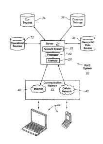
100401 FIG. I illustrates a Rig Activity Information Service ("RAIS")
system 20
including a communications network 22 according to an embodiment of the
present
invention. The exemplary RAIS system tracks, records, and manages global
drilling rig
activity data to present the data in a high-quality graphical user interface
using geospatial
8
CA 02841491 2014-02-03
models. In this exemplary embodiment, the RATS system 20 can include server 24
accessible via network 22 to host the interactive sessions of a plurality of
users. Server
24 has memory 26, accounting system 28, and a processor 30 to store operating
instructions therein, all of which being capable of bi-directional digital
and/or analog
communication with each other. Memory 26, however, could be a separate remote
database, a cluster of databases, or some other form of memory device.
Accounting
system 28 could also be a separate remote database, system, or processor.
(0041) A variety of remote data sources feed or "push" rig data and related
activity
data (data can also be "pulled") into server 24 to be stored in memory 26 and
used by
processor 30 during user interactive sessions. These data sources can include,
for
example, operational sources 32, (which refers to data obtained from
operations field
personnel), governmental sources 34, and commercial sources 36, all of which
are in bi-
directional analog and digital communication with server 24. This data can be
uploaded
into remote data sources (32, 34, and 36) via any methods well-known in the
art. Once
uploaded, it is transmitted (or pushed) to server 24. In the alternative, the
data can also be
"pulled," or requested, by users during interactive sessions via communication
devices 44.
Note, communication devices 44 need not be in continuous communication with
server
24. According to an embodiment of the system 20, applicable data for a
predetermined
area of operation can be "pulled" from the system 20, reviewed, displayed,
and/or updated
off-line, and later "pushed" back onto the system 20 using a synchronization
process as
known to those skilled in the art
[0042] A geospatial database 38 is also in bi-directional communication
with server 24
in order to provide geological, geographical, economic, cultural, or political
data relevant
to rig activity. Once the data has been received from remote data sources (32,
34, 36, and
38) it is processed and integrated together by processor 30 in order to form a
geospatial
model.
[0043] In an exemplary embodiment, communications network 22 can include
cellular
network 40 and the Internet 42, each being capable of bi-directional analog
and digital
communications between each other. Server 24 can be any well known shared
computer
located on RAIS system 20, which can function as the gatekeeper, controlling
all
functions of the present invention. Processor 30 performs the logic,
computational, and
9
CA 02841491 2014-02-03
decision-making functions of RAIS system 20 and can take any form as
understood by
those in the art. Memory 26 can include volatile and nonvolatile memory known
to those
skilled in the art including, for example, RAM, ROM, and magnetic or optical
disks, just
to name a few. It should also be understood that the preferred server
configuration is
given by way of example and that other types of servers or computers
configured
according to various other methodologies known to those skilled in the art,
can be used.
[0044] Server 24, shown schematically in, for example, FIG. 1 can represent
a server,
server cluster, or server farm and is not limited to any individual physical
server. The
server sites may also be deployed as a server farm or server cluster managed
by a server a
telecommunications provider. The number of servers and their architecture and
configuration may be increased based upon usage, demand and capacity
requirements for
RATS system 20 or communications network 22.
[0045] In an exemplary embodiment, a cellular network 40 can also form part
of
communications network 22 and can take the form of any well known cellular
mobile
telephony system, thereby allowing users to access server 24 with a
communications
device 44, such as a cell phone. Any known telephony network can be integrated
into
communications network 22, such as those networks known in the art to support
various
communications devices such as smart phones, PDAs, Blackberries, or other
handheld
devices used to transmit both analog and digital voice, video, or data
information between
users. In addition to being a separate unit, server 24 can form part of
communications
network 22.
[0046] In another exemplary embodiment, server 24 can also be accessed
through
Internet network 42 via a plurality of communication devices 44, such as user
personal
computers. Each user communications device 44 can be positioned at one or more
user
sites remote from the server 24 and can take various forms such as, for
example, a
telephone, cell phone or personal computer that includes a display and input
keyboard as
is well known in the art. Although illustrated as a keyboard, a user's input
can be entered
by other forms of devices known to those skilled in the art such as, for
example, a light
pen, magnetic or optical card reader, trackball, touch screen, touchpad, or
mouse.
Further, user computers 44 can also take various forms known to those skilled
in the art
such as, for example, a desktop personal computer, a PDA, mobile telephone,
and still
CA 02841491 2014-02-03
other devices for accessing the Internet, that are adapted to interface with
communications network 22 while positioned remote from the server 24.
100471 Further, referring to FIG. 1, the data sources (32, 34, and 36) can
include a
variety of data related to, for example, attributes and activities of all
drilling rigs located
on RAIS system. This data, namely rig attributes and rig activities, can be
located on the
same or separate databases. In an exemplary embodiment, for each rig having
attribute
data corresponding thereto, RAIS system 20 also contains rig activity data for
that
particular rig (which is stored on a database, preferably one of data sources
32, 34, or 36).
[0048] In an exemplary embodiment, the rig attributes can include "rig
counts"
according to: (1) regions, such as, for example, the U.S., continents,
countries, counties,
states, or base geology (e.g., basins and geological provinces); (2) by
locations, such as
land or offshore; (3) by activity type, such as oil or gas drilling or
geothermal; (4) well
type, such as development, exploration, or infill; (5) well trajectory, such
as directional,
horizontal, or vertical; (6) physical attributes of rigs, such as equipment
type and power;
and (7) rig drilling and moving performance attributes. The rig activities can
include, for
example, rig counts according to time-indexed information on executed
projects, such as
time, location, objectives, KPIs, and outcomes.
100491 Data source 38 (e.g., Geospatial data) can provide information
related to
various attributes spatially referenced on the earth using Geospatial
Information System
("GIS") technology. GIS technology provides systems for storing, capturing,
analyzing,
and managing data and associated attributes, which are spatially referenced on
the earth.
More specifically, it is a computer system capable of integrating, storing,
editing,
analyzing, sharing, and displaying geographically-referenced information. GIS
also
allows users to create interactive queries or searches, analyze the spatial
information, and
edit the data. Any GIS technology well known in the art can be utilized with
embodiments of the present invention. For example, GIS tools allow one to
relate
information about certain attributes of a state, such as drilling rig numbers
and locations,
to aerial photographs of the state. The primary requirement for the source
data consists of
knowing the location for the variables. The locations may be annotated by z,
y, and z
coordinates of longitude, latitude, and elevation, or by other geocode systems
like ZIP
11
CA 02841491 2014-02-03
codes or by highway mile markers. Any variable that can be located spatially
can be fed
into a GIS.
[00501 As shown in FIG. 1, the data received by server 24 from data sources
32, 34,
36, and 38 can be used by processor 30 to create a graphical user interface
utilized during
user sessions. Geospatial data source 38 can also be responsible for
maintaining
relationships between the location of projects executed by rigs identified by
the other
databases (data sources 32, 34, and 36) and geological, economic, political,
and cultural
records relevant to the decision process of information consumers. Processor
30 can
utilize the data from data sources 32, 34, and 36 and can integrate it with
data received
from geospatial data source 38 (using GIS technology) to produce a graphical
map
illustrating the desired data. For example, GIS can utilize satellite images
generated
through remote sensing to produce a map-like layer of the number of rigs in a
given area,
historical rig attributes, time-based animations of rig behavior, or any other
desired
attribute.
100511 The GIS technology used by processor 30 also can allow a user to
personalize
the interactive geographical visualization of the rig activity data received
from data
sources 32, 34, 36, and 38 and displayed on communication devices 44. A
feature of
embodiment of the present invention allows individuals to tailor the type,
amount, and
format of the data they desire to pull, as well as when they wish to have an
update and
through which channel (e.g., website, RSS feed, etc.). Such personalized
attributes can
include: (1) information (both "pushed" and "pulled") based on user profiles
registered
with server 24; (2) user queries which present geospatial interfaces that
visualize rig
activity information based upon a combination of attributes such as, for
example, (a)
business attributes based upon specified operators or service companies; (b)
rig attributes
specified by rig equipment or performance; (c) activity attributes specified
by oil or gas
drilling or time of drilling; (d) location attributes specified by
latitude/longitude,
geographical or political jurisdictions, or onshore/offshore data; (e) geology
attributes
specified by geological provinces or basins; or (f) historical or time-
dependent attributes,
such as evolution of rig (or related) activity in a region over a period of
time; (3)
geospatial presentation of activity information layered on top of economic,
geological or
geographical, political, or cultural data; and/or (4) attributes which dictate
how often the
12
CA 02841491 2014-02-03
user desires to receive the rig data (e.g., fixed calendar intervals, in
response to certain
events, or on-demand).
[0052] Once the user has entered these personalized attributes, processor
30 integrates
the data, using the GIS technology, for example, and transmits the data over
communications network 22 to communication devices 44. Once received by
communication devices 44, a map having the data layered on top (reflecting the
personalized attributes entered by the user or retrieved from the stored user
profile) is
displayed on a display screen of communications device 44. In addition, the
processor 30
can also transmit a time-based animation of rig behavior and related data for
display on
communications device 44.
[0053] RAIS system 20 can deliver the requested data to the user in any of
the well-
known presentation formats (e.g., HTML, XML, etc), which will allow users to
programmatically transfer and integrate the data into their own analysis
packages. In
addition, graphical presentations of the rig data, using the GIS technology,
enable RAIS
system 20 to allow the visualization of trends through "playing' (as a motion
picture) the
rig data. This beneficially can provide users an insight on individual rig
behavior (e.g.,
rig movements over a period of time, depths drilled over time, etc.), or rig
herd behavior
(e.g., movements of rig types, defining attributes, etc.) over periods of
time.
[0054j In another exemplary embodiment, processor 30 links rig activity
records data
received from remote data sources 32, 34, 36, with rig activity accounts data
also received
from the same. A double entry bookkeeping method and/or direct transfer-
immediate
update method, for example, can be used to manage rig transfers between
accounts.
Referring to FIG. 2, rig activity accounts 46 are bundles of data relating to
specific rigs
and their activity, which have been separated into discrete groups, called rig
activity
'accounts. For example, such accounts can include all rigs in a specified
region, state,
country, etc. According to one configuration, a rig activity controller is
assigned to each
account. An organization of rig activity controllers is responsible for the
operation and
quality assurance of the rig activity accounts data.
[0055] Quality assurance of the rig counts is a critical component of the
present
invention. In order to ensure a high level of data reliability and to reduce,
eliminate, or
=
13
CA 02841491 2014-02-03
estimate uncertainty (noise) in the rig counts, the rig activity accounting
process is
organized hierarchically as illustrated in FIG. 2. In an exemplary embodiment,
within
sever 24, RAIS system 20 can maintain a master database of all available rigs
worldwide
at any given time. RAIS system personnel continuously update and verify the
data
related to their respective accounts (via remote data source 32) and transmit
it to server
24. As illustrated in FIG. 2, for example, the rig accounting hierarchy in the
U.S. may be
structured geographically, such as, by state, stock point, county, etc.--
while, a rig
accounting hierarchy outside the U.S. may be structured by region, country,
etc. In yet
another example, the rig activity accounting hierarchies for rigs operating
offshore may
be structured based on the concept of blocks or leases.
[0056] Other criteria which may be used include hierarchies based on
operators or
contractors. As illustrated, Level 3 controllers report to Level 2
controllers, who then
report to Level 1 controllers. There can be up to N number of reporting levels
to
accomplish the desired requirements of the system. Also, the hierarchy can be
altered to
meet system requirements. This process of accounting and redundancy allows
RAIS
system 20 to maintain the most accurate and reliable data regarding rigs and
rig activity at
any given time.
100571 Once the data is reported and verified during the accounting
process, it is
uploaded and stored in memory 26. As reflected in FIG. 2, in an exemplary
embodiment,
memory 26 can contain separated linked databases for storing rig
identification and
attributes, called Rig System of Record (26b), and for storing transactional
activity data,
called Rig Activity System of Record (26a). In the alternative, however, these
database
can be combined into a single or multiple databases located remotely or within
memory
26.
[0058] To further ensure quality and reliability, this data is constantly
being updated
and verified by RAIS system 20 and uploaded into memory 26. In one exemplary
embodiment, however, such real-time data is only available internally to RAIS
system
personnel because it has not been verified. Once verified, the data is then
made available
to external users who can log on to server 24 via communication devices 44.
14
CA 02841491 2014-02-03
100591 Referring to FIG. 3, an exemplary embodiment according to a method
of using
the present invention will now be described. At step 101, a user logs into
server 24 via
communications device 44. The login process can be any method well known to
those
skilled in the art, such as those processors used in conjunction with a
website or portal
that requires a passcode to gain access. The website can also be subscription
and fee
based. The website can also or additionally be accessible to anyone in the
general public
or certain features of the website could be publicly accessible with other
specific or
proprietary data only available through a login.
100601 In the restricted configuration or portion, once the user has been
verified by
processor 30, the user is allowed access to features of RAIS system 20 via a
graphical
user interface at step 103. Here, processor 30 prompts the user to enter any
number of
attributes the user desires to be visualized in the corresponding map display
105_ Such
attributes would be entered via an input device on communications device 44
(not
shown). In the alternative, processor 30 could also retrieve (from memory 26)
a
previously stored profile of the user, which is then used by processor 30 to
retrieve the
desired data. Once entered, processor 30 processes the attribute data and
retrieves the
data from remote data sources 32, 34, 36, and 38 at step 107. In the
alternative, some or
all of the desired data may also be stored in memory 26 and can be accessed
accordingly.
At step. 109, processor 30 then integrates the data into a visual map or other
desired form
(such as chart, graph, etc.) and transmits it to communication device 44 for
display to the
user.
100611 FIG. 4 illustrates another exemplary embodiment of the system.
System 20'
can perform the above described functions of system 20 utilizing drilling rig
information
management program product 51 stored in memory 26 of server 24' and accessible
by
processor 30, along with one or more rig information databases 38' contained
on a
computer memory element (not shown) to relationally store drilling rig
attribute data,
drilling rig activity data, drilling rig assignment data, and drilling rig
geOspatial data,
either or all of which can include, e.g., time-stamped historical data. For
example, the
drilling rig attribute data including, e.g., drilling rig business attributes
(e.g., owner,
operator, etc.), drilling rig physical attributes (equipment, power,
trajectory, target
hydrocarbon, depth, etc.), and drilling rig performance data (moving
performance,
drilling performance) can be stored in a first database R. The drilling rig
activity data
CA 02841491 2014-02-03
including, e.g., time-indexed data on projects executed, project description
(includes time,
physical location(s), objectives, KPIs, outcomes), can be stored in a second
database A.
Notably, the drilling rig location data can include data beyond that normally
tracked such
as, for example, basin and/or geological province data. A third database P or
tables
within one of the above databases R, A, can maintain attribute and/or activity
data for rig
information provider personnel. A fourth database G, if implemented, can
maintain the
relationships between the location of projects executed by drilling rigs
(database A) and
geological/geographical, economic, political, and cultural records relevant to
the decision
processes of information consumers, including, for example, location of major
cities,
basin boundaries, geology, County boundaries, highway locations, state
boundaries,
mineral management service (MMS) areas, and MMS blocks, defining geospatial
information. Additional databases/records or tables within one or more of the
above-
described databases, can include, for example, information customers records,
other
assets, well attribute data including well type, well trajectory, etc.
[0062] As noted above, rig information databases 38' can also include
mapping data to
provide for the geospatial information. Alternatively, mapping data can be
extracted
through external database and combined with rig or well location data to
instead provide
the above described layering and visualization of activity data over digital
maps. In either
configuration, such visualizations can be provided through querying over the
communication network 22 by means of interactions with graphical presentations
of the
data displayed on user communication devices 44, which can enable new forms of
interpretation by supporting the visualization of trends through, e.g., visual
"playback" of
trend data that will provide insights on individual rig behavior (e.g., rig
movements over a
period of time, depths drilled overtime) or rig herd behavior (e.g., movements
of types
over periods of time), as will be described in more detail later.
[0063] User communication devices 44 can include various types of network
and
network capable devices including stationery and portable computers, PDAs,
cellular
phones, etc., which include a processor, memory coupled to the processor to
store
operating instructions therein (including, e.g., at least a rudimentary Web
browser or
other graphical application program) and to receive drilling rig activity data
and digital
mapping data. Each communication device can also include a user display in
communication with the processor of the user communication device 44 to
display indicia
16
CA 02841491 2014-02-03
of a drilling rig location and/or other activity or trend information overlaid
upon and
spatially oriented to at least portions of a displayed digital map. Each
communication
device 44 can further include a user interface in communication with the
processor of the
user communication device to provide each of a corresponding plurality of
users with
online access to the drilling rig activity data over the communication network
22 to
thereby view the drilling rig location for each of the plurality of drilling
rigs. Such
system configuration beneficially allows individual users to tailor the type,
amount, and
format of the data that they want to "pull'' when they wish to have an update
and through
which type of channel, and allows the system 20' to provide such information
using
different or variable criteria, such as, for example, historical (to provide
trend
information), at fixed calendar intervals, event driven (e.g., in response to
a local or a
global event or change in conditions), and on demand (e.g., just-in-time) such
as at a
critical stage in an investment decision-making process.
[00641 The drilling
rig information management program product 51 can be in the
form of microcode, programs, routines, and symbolic languages that provide a
specific set
for sets of ordered operations that control the functioning of the hardware
and direct its
operation, as known and understood by those skilled in the art. As perhaps the
shown in
FIG. 5, the program product 51 can also include various functional modules
containing
instructions that when executed by a processor of a computer, cause the
processor to
perform various operations. For example, program product 51 can include a data
receiver
-53 adapted to pull or otherwise receive data from various internal and
external sources
using, for example, a data entry form (not shown), and/or a data gatherer 55,
adapted to
manage a WebCrawler to monitor select database sources to retrieve data
updates. The
program product 51 also includes a queue 57 adapted to receive third party
drilling rig
attribute and activity data for data validation review. The data receiver 53,
data gatherer
55, queue 57, and/or a verified data tracker 59 are configured to notify a
reviewer that
data exists from a source other than an internal or external trusted source.
The verified
data tracker 59 manages sending an electronic message to a field
representative either
preselected, or selected, for example, by a data verification reviewer
requesting visual
verification of third party drilling rig activity data, and notifies the
reviewer upon receipt
of data verification to allow the viewer to release the newly acquired data
from the queue
57.
17
CA 02841491 2014-02-03
[00651 The drilling rig information management program product 51 can also
include
a rig activity status displayer 61 and a rig attribute displayer 63 to display
rig activities
and rig attributes, respectively, a rig transaction history displayer 65
display transaction
history for a selected one or more drilling rigs or projects, and a rig
activity status
recorder 67 and rig attribute recorder 69 adapted to receive data for updating
rig activity
and rig attributes, respectively, for example, via a respective Web browser
based database
entry form.
10066] The drilling rig information management program product 51 can
further
include a digital map interface 71 adapted to retrieve digital mapping data
(e.g.,
geological, economic, political, cultural) either directly from a and external
digital map
provider or via database 38, 38', and a location localizer 73 adapted to
spatially orient a
selected drilling rig or drilling rigs or projects with a selected portion of
a digital mapping
environment for display to a user, as shown for example in FIGS. 6 and 7.
[0067] As perhaps best shown in FIGS. 6-9, and as noted above, embodiments
of the
program product 51 provide geospatial visualizations and concise reporting
data
extending from the geospatial visualizations over the communication network 22
by
means of interactions with graphical presentations of the data displayed on
user
communication devices 44. FIG. 6, for example, illustrates a geospatial
webpage 81
containing a high-level view of any section of the world (here, the United
States)
positioned in a mapping field 83 overlaid with an illustration of various
drilling rigs and
operations (icons 85) at their respective locations. Webpage 81 includes a map
content
section 87 to allow user selection of the items to be layered over the digital
map in the
mapping field 83, along with statistics 89, and an activity interface 91. FIG.
7 illustrates a
more detailed view of a selected portion of a map overlaid with the drilling
rigs icons 85.
The activity interface 91 includes several features including icons for
performOg the
following functions of zoom in, zoom out, grab, zoom all the way out, select
drilling rigs
or projects for analysis, provide details for selected drilling rigs or
projects, clear
selections, provide reports, and provide time lapsed trend data. Specifically,
icon 93
illustrates a box manipulated via a user input device over the communication
network 22
to select one or more drilling rigs or projects. Having selected one or more
drilling rigs or
projects, icon 95 can be selected to provide rig details for the selected rigs
or projects as
shown, for example, in FIG. 8. Icon 97 can be selected to provide detailed
reports
18
CA 02841491 2014-02-03
including compiled and summarized information as shown, for example, in FIG.
9. Icon
99 can be selected to play back a visual display of the trend data such as,
for example,
movement of the drilling rig icons 85 in and out of the area of interest
(i.e., existence or
removal) and/or physical movement within the displayed area of interest, for
example, in
the form of streaming video. Beneficially, such imagery enhances visualization
of a
growth or decline in the area of interest. Note, the drilling rigs or projects
were overlaid
upon the map image in FIGS. 6 and 7. Alternatively, the image could have been
a
vertical planar or three-dimensional image illustrating depth into the earth.
Accordingly,
the trend information could show progression in an increase in a depth,
changes in
trajectory, or other data, for either an individual drilling rig or project,
or a herd of drilling
rigs or projects.
[0068] Additionally, other icons (not shown) can include those to provide
either
reports or trend information, visually illustrated as a function of time
(i.e., progressive
motion), or simple graphs or spreadsheets providing crew record data, power
ratings of
motors on the rig, reliability or maintenance records. Such other icons can
also include
those to provide real-time video at the site, or portions thereof, or a
picture of the rig, etc.
[0069] Embodiments of the present invention address the root cause of
drilling rig
accounting problems, "noise" due to an accurate observations and
implementation of
unverified drilling rig attribute and activity data. As perhaps best shown in
FIGS. 10-19,
embodiments of the present invention include procedures defined for, e.g.,
field operators,
rig controllers, etc., that eliminate or mitigate "noise" that allows a rig
count information
service provider to estimate the level of uncertainty or "noise" in the rig
counts, and that
provides quality assurance of the rig counts prior to provision to end-users
(e.g.,
information consumers).
[0070] For example, as shown in FIG. 10-14, data verification is provided,
for
example, through direct visiting of the drilling rigs by field
representatives, and the
investigation of assigned rigs to allow verified updates to transaction tables
and drilling
rig databases. As perhaps best shown in FIG. 10, rig accounting has been
beneficially
made separate, but complementary, to drilling bit record management, to
provide a single
entry point for updating and managing both drilling bit record and drilling
rig activity and
information records. Such rig accounting can include defined accounting
periods with
19
CA 02841491 2014-02-03
reconciliation procedures including movements and move-outs, implementation of
a rig
accounting standard handbook to provide standard accounting procedures to
field
representatives, and transparency, particularly with respect to on demand
auditable
"books" and reporting to management. As perhaps best shown in FIG. 11,
according to a
preferred configuration, District Regional Controllers assign rig information
received
from third parties or other controllers for investigation of discrepancies and
to "close the
books." As perhaps best shown in FIG. 12, specific Controllers investigate
discrepancies;
clear the discrepancies from the Geospatial Information System, e.g., data
source 38, or
from database 38'; and update the final "corrected" numbers. As perhaps best
shown in
FIG. 13, an Information Reviewer approves the rig count data for release to
external
customers.
[0071] Beneficially, application of such dedicated roles responsible for
rig activity
accounting, e.g., region or district-level rig activity controller and rate
master coordinator,
approval for public release of data further enhances not only third party
trust in the
accuracy of the databases, but enhanced prevention of corruption of the
database with
faulty data. Note, FIG. 14 illustrates a sample high-level flow diagram of
steps involved
in validating newly acquired drilling rig activity or attribute data, and
FIGS. 15-19 further
illustrate specific process flow diagrams to further enhance data
verification.
[0072] As illustrated in FIG. 14, a method to monitor drilling rig activity
and to
provide drilling rig information can include the steps or operations of
receiving drilling
rig activity or attribute data from a plurality of users entered into a
standardized Web
based database entry form (step 121), and if the users are internal users or
otherwise
trusted data sources (step 123), storing the internally supplied drilling rig
activity or
attribute data in a rig information database responsive to receipt of the
drilling rig activity
or attribute data (step 125). If the data sources are not trusted data sources
as identified in
step 123 (i.e., if the level of uncertainty of the data is unacceptable), the
method further
includes queuing the received third party drilling rig activity or attribute
data for data
validation review (step 127); requesting, e.g., visual, verification of third
party drilling rig
activity or attribute data (step 129), receiving indicia of physical
verification of the
received third party drilling rig activity or attribute data from an internal
user (e.g., field
representative) defining a data verification acknowledgment (step 131);
releasing the third
party drilling rig activity or attribute data from the queue responsive to
receipt of the data
CA 02841491 2014-02-03
verification acknowledgment (step 133), and storing the third party drilling
rig activity or
attribute data in the rig information database 38' (step 125).
100731 As noted above, embodiments of the present invention move the
"counting"
paradigm to that of "accounting." FIGS. 15-19 illustrate various process flow
diagrams
that provide an enhanced methodology for storing, updating, and displaying
such
=
improved data. Additionally, FIGS. 6-9 and 20-27 provide examples of an
enhanced
graphical user interface for storing, updating, and displaying such improved
data. Note,
only select Web-type page screenshots are shown to enhance clarity.
10074] For example, as shown in FIG. 20, through selection of "my rigs"
field 151 on
the rig organizer page 150, embodiments of the present invention allow users,
such as, for
example, field representatives, to view a list 153 of rigs that are directly
assigned to them.
The provided list 153 of drilling rigs, is, by default, sorted first by status
155 (with
"Active Drilling" first), then by Contractor 157, and then by RigName 159.
Users, e.g.,
field operation managers, through selection of the "my locations" field 161,
for example,
can view the list of rigs that are located in any of the business units in
which the manager
is a member based on the most recent rig transaction. Similarly, through
selection of the
"my associates" field 163, the user can view the unique list of rigs that are
associated to
any of the persons assigned to any of the locations in which the user is a
member. This
list (not shown) is, by default, grouped, e.g., by Contractor, then sorted
first by status
(with "Active Drilling" first), then by Contractor, and then by RigName.
Through
selection of the "unknown location" field 165, users can view the list of rigs
that have no
location value assigned based on the most recent rig transaction. This list
(not shown) is,
by default, sorted first by status (with "Active Drilling" first) and then by
updated date.
[0075] According to a preferred configuration, each of the above scenarios
can
produce a rig list data set which contains the following fields:
Rigs Organizer Field List
Field Description
Contractor The name of the Contractor.
Rig Name Name of the rig.
Rig Class Rig classification (barge, ship, jack up, etc).
Location Shows geographical location of the rig, if available. For
offshore this will be the offshore "county" concatenated with
offshore block. For onshore, it will be the state concatenated
21
CA 02841491 2014-02-03
with county. If the location is Unknown, third party data is
used if available.
Status Displays the Current Rig (transaction) Status. If the
location is
Unknown and status is Unassigned, third party data is used if
available.
Last Date Displays the date (only) of the last transaction status.
Operator The name of the Operator. If the rig is not in Active
Drilling
status, then this column is empty
File No. Displays the well's file No. (if the status is active
drilling). The
file number is hyperlinked and when selected, will direct the
user to the bid management page ("Webbits") displaying the
well header screen corresponding to this File No.
API No. Displays the well's API No., if it exists.
Alert Status Displays an icon if one or more of the following alerts have
been triggered for this rig:
= Third Party Data is Newer: Either "3rd Party Data indicates
this rig reached total depth well XYZ on <DATE>" or ,43rd
Party Data indicates this rig Spud'ed well XYZ on
<DATE>"; these alerts compare the total depth date and
Spud date from third party data to the RAIS transaction data
and raise an alert if this date is different so long as the third-
party date date is newer than the transaction date.
= Rig is Stale; the rig has not been updated since the
allowable threshold; this is controlled by the rig class with
the units being in days.
= Rig has Unknown Location.
= Rig has Unknown Status.
= Active Rig is Active without well header.
When the user puts the mouse over the icon, the specific alerts
are displayed in a tool tip.
Watch Status The watch status displays one of four icons indicating who is
watching the rig.
= No one in the location is watching
= I'm watching
= Someone (anywhere) is watching
= Both are watching
When the user puts the mouse over the icon, the specific list of
users watching the rig is displayed.
[0076] According to this configuration, the user can manipulate the rig
list in the
following manner: Sorting: The user will be able to sort on any single column
in the list
by clicking on the column name cell. When the same column name is clicked
repeatedly,
the sort order is reversed from the previous order. The initial or "default"
sort is first by
"Activity Status" showing active, active not drilling, moving, stacked, and
unknown in
this order and then by updated date. Grouping: The rig list can be grouped by
one or
22
CA 02841491 2014-02-03
more columns, for example, when the user drags the column above the grid
header.
Paging: The rig list will be paged to limit the number of records displayed
at one time.
Column Order: The user may manipulate the column order in the rig list by
dragging the
columns in front or behind of each other. According to a preferred
configuration, none of
the custom settings are persisted or saved with the user profile, meaning that
any custom
view can't be stored and retrieved later. The records can also be sorted by
each column
= (single column sort), for example, when the column header is selected.
[00771 In the
exemplary illustration, each item 170 in the rig list (e.g., list 153)
contains a checkbox 171 that allows the user to toggle the rig items and the
ability to
toggle all items (to check or clear all). Two buttons 173, 175, below the list
enable the
user to "Follow Rig" or to "Release Rig." The "Follow Rig" button 173 is
disabled if the
"View By Assignment" dropdown has been selected to display "My Rigs." In
addition,
the "Follow Rig" and "Release Rig" buttons 173, 175, should be disabled when
no items
are checked in the rig list and enabled only when one ore more items in the
list have been
checked. Further, each item or record (row) 170 in the rig list 153. can be
double clicked
which loads the "rig details' page 200 (FIG. 21) displaying the rig details of
the double
clicked rig. That is, the user can click an individual rig item or record 170,
which then
starts, for example, a rig details module to allow the user to drill into the
details of the rig.
Each checkbox for each rig record also enables the user to "Unassign this rig"
which
removes the association between that user and the rig, i.e., through selection
of the
"release rig" button 177. A notation of this operation is placed in the rig's
audit
(transaction) history to track such details. The organizer page 150 also
contains a "View
By" filter graphically illustrated at 179 that, as shown in the figure, is, by
default, set to
"rigs assigned to me" (or "My Rigs"), but can also be changed to "rigs by.
territory" (or
"My Locations") which presents a list of territories assigned to the user
(such as stock
points). By default all rigs associated with all territories assigned to the
user are
displayed. When the user selects a specific territory, the rig list is
filtered by rigs in that
territory (not by person assignment). A third filter can include "rigs not
assigned to a
territory" (or "Unknown Location") that displays all of the rigs that do not
have any
territory which could occur for various reasons but mostly when a rep creates
a "move"
transaction without specifying the new location. This feature is provided so
that if a field
23
CA 02841491 2014-02-03
representative is "driving around" and discovers a rig that is not in his area
in the system,
the rig can be entered into the system.
[00781 According to an embodiment of the present invention, when a request
to view
the organizer page 150 is received by the user interface of the system, the
system will first
determine the identity of the person making the request. Then, for each item
in the
composite, the system calls a series of operations to retrieve the data for
that component
and for that person. The object retrieved is a representation of the data to
be
presented/rendered. Then the system updates each of the corresponding user
interface
components with the data retrieved for that specific component According to
this
exemplary embodiment of the system, the rules/criteria for the datasets are as
follows:
MyRigs Returns all rigs associated to that identity making the request.
Rig Watch Returns the list of all rigs in his rig watch. The rig watch is a
list of rig
"alerts" that was added in the database for the specific user and rig and
that is only removed from this list once the user either associates the rig
to himself or explicitly says "remove from this list."
Alerts Returns all alerts assigned to that user that are still have an
opened state.
Activity Watch Returns the list of all rigs assigned to that person that also
have the last
activity date value less then the configurable stale activity threshold
time span. This value is configurable by rig type and so first the type of
rig must be checked and then the appropriate configurable time-span
value is used to get the list of rigs.
Score Card Returns scores for that user.
[00791 As noted above, embodiments of the system 20, 20', allow the user to
view the
list of rigs assigned to him/or (default view) on the organizer page 150. The
"My Rigs" is
an area or region (like a web part) within the organizer page 150 that lists
each rig
assigned to the user in a grid or tabular format. According to alternative
configuration
(not shown), the grid contains the rig identification, contractor, telephone,
rig watch
status, activity watch status, and current activity status columns and latest
update date.
The rig and activity watch status columns list contain an indicator such as an
icon, which 4
indicates that this type of item is present (rig watch, activity watch is set
on this rig) while
the activity status column contains the actual status of the activity itself.
The following
five characters provide a standard status: AD for "Active Drilling"; AND for
"Active Not
Drilling"; SSO for "Stacked or Suspended Operation"; UO for
"Unassigned/Opportunity";
and M for "Moving." Note, for rigs associated with a well, the system can
display the
well record in an additional "well information" field or screen, which is part
of the rig
24
CA 02841491 2014-02-03
record. This well information field will be empty if there is no well
associated with a
particular rig record.
[00801 The embodiments of the system 20, 20', allow the user to display a
list of new
rigs arriving into the area set, for example, by the "District Champion," for
which field
users can assign to themselves. To perform such display, the user first views
the "rig
watch" section 191 of the organizer page 150 (FIG. 20). The rig watch section
191 is a
portion of the organizer page 150 that can list rigs, including those that are
moving to the
user's specified area. According to one configuration, the criteria for
displaying the rig to
the current user listed in his/her rig list 153 is defined as follows: When a
rig is moved
(geographical location change) a record is created in the rig watch for each
person that is
assigned to a stockpoint associated with that "new" geographical location
which the rig
has been "moved" to (or assigned to). Even if the user is already assigned
explicitly to
that rig the user will receive a notification which could happen if the rig
was moved out
and back in for some reason (maybe data error) and that person hadn't
"unassigned" it
from him/herself directly. Rigs are removed from this list if and only if the
user assigns
one or more of them to him/herself, for example, using the "assigned rig"
button 173, or
has explicitly clicked "take off my list" ("release rig" field 179) which
removes it from
the list. As noted above, this particular section includes table or list 153
which can show
the "my rigs" by rig identification and contractor, which, upon selection,
provides the
user the ability to view its details and/or also assign it to himself, or if
logged in with, e.g.
a Field Manager role, allows the rig to be assigned to him/herself and/or to
any other ,
person associated to that same stockpoint.
(00811 The embodiments of the system 20, 20', also allow the user to
display a list of
rigs that have not been updated/validated/confirmed within the allowable time
span. To
perform such display, the user first views the activity watch section 193 of
the rig details
page 200 (FIG. 21) selected, for example, through the organizer page 150. The
activity
watch section 193 provides various alerts including identification rigs that
are assigned to
= the user which have not been updated within a period of time defined in
the system. The
system should determine both the type of rig and the check the time span that
is
associated for that particular rig type. The user can click an individual rig
identification
or contractor, which then causes display of rig details to allow the user to
drill into the
details of the rig.
CA 02841491 2014-02-03
[0082] As perhaps best shown in FIG. 22, Rig Activity Location Controllers
and other
Rig Controllers are provided additional data in the form of transactions
related to all of
the rigs in all of the territories assigned to user from the latest snapshot
data source, while
the live grid contains all of the rigs assigned to all territories associated
with the user
using the "latest" entry from the live transactions for that rig, with a
default showing all
rigs grouped by location and categorization. Specifically, the user can be
presented with
a grid containing the rig transaction data displaying various combinations of
the following
fields: rig identification; type; contractor; current accounting status; date
of last
accounting update; district; stocicpoint; if the rig is assigned and/or who it
is assigned to;
and contains exceptions (snapshot view only). The ''contains exceptions" field
(not
shown) can be a button that is only present if there is one or more
exceptions. When
clicked, it presents the user with a grid of all the exceptions that apply to
this rig.
Beneficially, the user can filter the rigs by a number of criteria. Each
criterion is
displayed with a dropdown box that includes an implicit "all" and is presented
just above
the grid itself.
[0083] The various filters used to display the data can include, for
example: "By
Contractor"; "By Accounting Status"; "Rigs without geographical location set";
"By Any
Territory (region, district, stocicpoint, etc.)"; if it contains zero or more
"exceptions"; if
there is at least one person assigned to it or not; if there is at least one
person assigned to
it in the same geographic location; last transaction date is greater than one
week
(configurable); pervious transaction was greater then 4 weeks (configurable)
than the last
transaction; "View Rigs Not Serviced"--e.g., all rigs that a certain
proprietor does not do
business with; "View Previous Rig Categorization"--e.g., how rigs were
categorized
historically for a previous count; "View Changed Rig Categorization"--rigs
that have been
updated to a new categorization in the current time period; and "View Rig
Movement by
Location"--a list of rigs that have moved into or out of a user's assigned
territory. Note,
the illustrated embodiment in FIG. 22 is "by Period." According to a preferred
configuration, the filter criteria are already "pre-filtered" based on that
person's access.
For example, if a Controller is only granted access to a limited number of
regions or
districts, that Controller can only "see" these in the controller's dropdown
list.
[0084] The user can sort the data by any single column, for example, by
clicking on
the column header. "Clicking" the same column again sorts the data in reverse
order on
26
CA 02841491 2014-02-03
that same column. The grid is paginated to limit the amount of data displayed.
The
number of records per page is configurable by the user with a default setting
of "twenty."
The user may view the next or previous page (if applicable) and also "jump" to
a specific
page by selecting the indicator for that page. The user may also click on one
of the rig
records, which will cause to display of the "Rig Details" page 200 (FIG. 21).
[0085] As shown in FIGS. 21 and 23, embodiments of the system 20, 20', provide
a
list of all rig transactions (transaction history) for a specified rig to
provide intelligence
about rig activity. Notably, such transaction history can be collectively used
to provide
trend information for not only the specific rig, but categories of rigs,
locations, etc.
Specifically, according to a preferred configuration, the following
transaction history is
provided:
Rig Transaction History Field List
Field Description
Transaction Date The date of the transaction (converted to
users local time).
Operator The operator from the transaction (Active
Transactions only).
Status One of the Rig Activity Statuses.
Business Unit The Stockpoint or District where the rig is
located.
Comment Description of the transaction.
Well Name Name of the well the rig is drilling (Active
Transactions only).
Well Number Number of the well the rig is drilling (Active
Transactions only).
SPUD Date Date a well is spuded (Active Transactions
only).
[0086] As shown in FIGS. 24 and 25, embodiments of the system 20, 20',
enable the
user to navigate well header information, particularly for a rig having
'active drilling"
status. For example, according to a preferred configuration, if the rig status
is set to
"Active Drilling," the user is provided a "Continue to Webbits" button 201 on
the rig
details page 200 (FIG. 24), which can be selected, for example, to activate a
bit
management portion of the system, to display a well header records/details
screen 203,
for example, as shown.
27
CA 02841491 2014-02-03
[0087] Similarly, when the user is viewing the organizer page 150 (FIG. 20)
and wants
to see the listing of all wells attached to rigs assigned to him/her, the user
can select a
specific rig to thereby launch the rig details page 200 (FIGS. 21 and 24). If
the rig
assigned to that user is associated with a well, then the well record
information can be
displayed in display screen 203. The well record and displayed well
information can
include the well identification number, well name, well location, and the bit
record. The
user can then "click" the bit record field or button 205 in the displayed well
record to
view the bit record details provided by the bits management portion of the
system 20, 20'
(e.g., "Webbits"). Note, if there is no well assigned to that rig, the
corresponding well
record will be blank.
[0088] Referring again to FIG. 21, embodiments of the present invention
allow a user
to update the activity status of a selected rig according to the below
describes steps.
[00891 Step #1-Set Current Status. To set current status having selected
rig details via
selection of a rig from the list in FIG. 20, and the "activity status" tab 207
if not already
selected, the user is presented the fields shown in FIG. 21, for example.
Using the current
status drop-down box 209, the user selects the current activity status of the
rig from one
of the following choices: AD for "Active Drilling"; and for "Active Not
Drilling"; SSO
for "Stacked or Suspended Operation"; UO for "Unassigned/Opportunity"; and M
for
"Moving." If the user selects the "AD--Active Drilling" option, then the
control flow
branches from this main scenario to one of the two alternative scenarios,
depending on
the user participating in the scenario. If any other selection is made,
control continues to
Step #2, below.
[0090] Step #2-Add Compulsory Comments. To add compulsory comments, using a
multi-line "Comments" text box, the user enters comments to describe the
transaction.
[0091] Step #3-Update Optional Location Info. The location information
includes
both geopolitical and business unit location. The current or latest locations
of the rig are
displayed to the user using a series of controls enabling the user to either
accept or update
the current location of the rig. For the geopolitical location, the controls
can include the
following selection-type (dropdown) controls: "country"; "state/province"; and
"county/offshore location." If the location type is set to "offshore," then an
additional
28
CA 02841491 2014-02-03
text box control is visible which contains an optional offshore block
attribute that can be
manually typed in. For the business unit location, the controls can include
the following
selection-type (dropdown) controls: "Region"; "Area"; "District";
"Stockpoint"; and
"Sales Territory" (normally only visible if the Stockpoint has associated
territories). If
any of the location levels is not known (such as county, state, stockpoint,
etc), then the
user may choose an "unknown" selection in that box. If the entire location is
not known,
then the user should select a check box labeled "unknown," which disables all
other rig
location controls. The user can select any of the valid geopolitical and
business unit
locations in the system regardless if he is assigned to them via the territory
assignment
since he might need to indicate that the rig is moving to a geographical area
outside his
responsibility.
[00921 Step #4-Save the Record. The records can be saved by selecting the
save
button which creates a new rig transaction object and is saved to the
database. The user
optionally may choose the "cancel" button, which prompts the user for
confirmation and
then cancels the operation.
[0093] According to an alternative scenario different users are given
different
permissions. For example, where the user is a Field Rep or Field Ops Manager,
all
controls defined above are disabled, except, for example, for the "cancel"
button. Instead
of a "save" button, the user sees a "Continue to WebBits" button 201 (FIG.
24). When
clicked, the button directs 201 the user to the Rig Search screen in WebBits
(part of the
API number search functionality) that attempts to locate an existing well
header (or 3rd
party well info) for the selected rig.
[00941 According to another alternative scenario such as, for example,
where the user
is a District Controller, Region Controller, or Company Controller, a panel
appears below
the current status drop down displaying the active drilling transaction
criteria fields to be
entered. No default values are set. Such user can add/enter data such as, for
example, the
following active drilling criteria needed for and active transaction to be
saved:
Active Drilling Transaction Criteria
Attribute Description
Day Work DayWork name lookup.
Direction The directional type name lookup.
Est. Total Depth Estimated total depth in feet.
29
CA 02841491 2014-02-03
Geographical Contains the latitude, longitude, and
Location elevation.
Land Formation Name of the land formation lookup.
Mineral Type Name of the mineral being drilled for
lookup.
Operator Name of the operator lookup.
Spud Date Est. date the well was spud-ed.
Well Type The name of the type of well lookup.
The user then continues on to add compulsory comments as described with
respect to
"step #2," above. Notably, various other embodiments are within the scope of
the present
invention.
[0095] As shown in FIG. 26, users are provided reports such as, for
example, various
snapshots of data including, e.g., data for validating a rig count for an
accounting period
as shown in the figure, used to begin the process of "closing books." Such
validation can
be by location/total and/or for a specified time period. Other reports
include, for
example, exception reports which can include, e.g., the following information:
rigs that
have been moving for more than four days (last activity is moving and was made
greater
than four days ago (configurable)); rigs that have moved but have not been
picked up by
another user in the new location (i.e., where there are no users within the
geographical
area assigned to this rig); rigs with no persons assigned to them (e.g., no
reps, etc); rigs
that are set to unassigned; rigs with no geographical location set, rigs
moving with no
location set, rigs set to active with missing data, such as, location and/or
well type, rig
type, mineral type, configuration type, depth, etc; new rigs; and rigs with no
designation.
[0096] Embodiments of the present invention also enable a user to reconcile
all the
transactions for a period for the user's assigned business unit(s) and "close
the books" for
the period in that business unit(s). Specifically, embodiments of the present
invention
allow the user to view data about the rig count for his responsible business
unit and
period, make corrections by entering rig transactions, sign off on the
required fields, enter
closing comments and close the business unit for the period. Applicable
portions of the
program product are launched via a "View. Rig Transactions by Period" screen
210 (FIG.
22). According to a preferred configuration, by default the current period is
displayed in
field 211. A series of drop down boxes 213, 215, 217, are also displayed
allowing the
user to select the desired Region, District, and Stock point, respectively. By
default, the
appropriate region, district and stock point are selected corresponding to the
user's role
CA 02841491 2014-02-03
permissions and business unit assignments. For example, a District Controller
would
have his region and district already chosen with "all" selected for the stock
point while a
region controller would have his region and "all" selected for the district
and stock point
whereas the Company Controller would have "all" selected for all three
dropdowns The
current status of the period and the business unit is displayed to the user.
Period closing
states are defined as:
Event Seq Event Desc Detail
1 Field Closed The period is ready to be reconciled and closed
for each of
the districts for the period. Field users' transactions are no
longer entered into this period but entered into the next
period.
2 District The period is ready to be reconciled and closed for
each of
Closed the regions for the period. District controllers can
no longer
modify records for that period.
3 Region The period is ready to be reconciled and closed for
the entire
Closed corporation. District and Region controllers can no
longer
modify records for that period.
4 Period Closed The location is closed and is read-only. The period
can NOT
be reopened for that period for editing.
[0097] Business unit states (for a specific period) are defined, for
example, as:
State Detail
Open The period is ready to be reconciled and closed for each of the districts
for the
period. Field users' transactions are not entered into this period but entered
into
the next period.
Closed The period is ready to be reconciled and closed for each of the regions
for the
period. District Controllers can no longer modify records for that period.
100981 In order to reconcile and close the period, the user chooses a
period/business
unit combination that the user has access to and is currently open. After
choosing the
business and period, the user is presented with two informational lists that
show all of the
intelligence needed to reconcile and close a business unit for that period¨the
Period
Variance Listing and the Rig Alerts Listing. The user is also presented with a
button to
"View Closing Comments." When clicked, a new modal window (or popup window) is
displayed showing a printer friendly version of each district name, user name,
and the
comment entered by that user for the district when it was closed, grouped by
region. The
list is filtered by region so only a single region is shown at a time unless
"all" is selected
31
CA 02841491 2014-02-03
in the region box. Districts that are not closed (and therefore have no
comments) are not
shown, according to this exemplary configuration.
[0099] Period Variance Listing. The period variance section 221 displays a
listing of
the total count of rigs for the currently selected business unit and period
combination
grouped by the following criteria:
Grouping Description
Active Drilling Total rigs with a current status of "Active
Drilling"
for the period.
Active Not Drilling Total rigs with a current status of "Active Not
Drilling" for the period.
Stacked or Suspended Total rigs with a current status of "Stacked or
Operation Suspended Operation" for the period.
Moving Total rigs with a current status of "Moving" for the
period.
Unassigned/Opportunity Total rigs with a current status of
"Unassigned/Opportunity" for the period.
Move Ins Total number of rigs that moved in this period.
Move Outs Total number of rigs that moved out this period.
Total Rigs Total number of rigs for the period.
[00100] Each row in the listing, according to this exemplary configuration,
shows the
user: the value for the: the current period total; the previous period total;
the change in the
total; and the percent change in the total. If the absolute value of the
percent change
exceeds a configurable threshold (set at 5% initially), then a visual alert is
displayed for
that entire row (grouping) using an alternate row color. The user can click on
any of the
rows, which can then navigate the user to a new screen which displays a list
of the rigs in
that grouping.
[00101] Rig Alerts Listing. The rig alerts section 231 shows a listing of any
rigs in the
current period-business unit combination that violate one or more of the
defined rig
exception alerts. The list displays the following fields:
Field Description
Rig Contains a concatenation of the Contractor Name
and the Rig Name.
District Name of the district in which the rig is located.
Stockpoint Name of the stockpoint the in which the rig is
located.
32
CA 02841491 2014-02-03
Location Displays the physical or geopolitical location of the
rig such as a county or offshore area.
Status Latest Rig Activity Status.
Updated Displays the day of the week and date of the last
update like, "Mon, 12/04/2006."
Unwatched Indicates that the rig is not being watched by anyone
in its current stockpoint. This field is empty if not in
this condition.
30Days The rig was in an Unassigned/Opportunity status for
30 days or more and now is NOT in an Unassigned/
Opportunity status this period. This field is empty if
not in this condition.
Newer3PD The rig has third party data with a newer transaction
date than RAIS. This field is empty if not in this
condition.
StaleDays Indicates the number of days that have elapsed past
the last updated and the required update interval for
the rig based on its rig class. This field is empty if
not in this condition.
Investigated A checkbox that indicates that someone has marked
the rig as being investigated. The user can check this
box directly in the grid. This box is automatically
cleared by the system when a new transaction is
entered for this rig by any controller.
[00102] There is a check box 241 labeled, "Included Rigs with Unknown
Locations"
that is not checked by default, according to this configuration. When checked,
the Rig
Alert listing will include all rigs that have an unknown location, which
therefore, will
contain null values for the District, Stockpoint, and Location columns. The
Rig Alerts
listing is sortable by any of the fields and also supports record paging with,
e.g., twenty
rows per page.
[00103] After viewing the information for that business unit, it is possible
that some of
the data needs to be reconciled and updated based on furtherer analysis and
communications with field personnel. To do this, the user enters one or more
rig activity
transactions for a rig. The user would either drill directly into rig
information details
accessed through the Rig Alerts section 231 of the screen page 210 or by first
navigating
through "Variance Rig List by Business Unit" from the Period Variance section
221 of
the screen page 210 to get to the rig detail. Once viewing rig detail the user
would use a
"Rig Transaction" screen (not shown) to add rig transactions.
33
CA 02841491 2014-02-03
[00104] In order for the user to ultimately close the business unit, he/she
will sign off
on selected items on the lists simply by clicking a check box. The following
items on the
period variance list are typically required for signoff and do not require any
particular
order: Move In; Move Outs; Total Rigs; and Any of the remaining activity
statuses in
which the percent change exceeds the configurable threshold (set, e.g., at 5%
initially).
While any user defined for this use case may view data, only users that are
viewing the
business unit that they have access to (by their role and business unit
assignment
combination) will be able to actually sign-off on this data. Otherwise, the
checkboxes are
not even visible.
[00105] Once all required sign offs have been made, a "Close Business Unit"
button
becomes enabled. The user clicks this button, which displays an additional
modal form
(or popup window) requiring the user to enter in compulsory comments for the
business
unit and period. The screen shows the period, business unit, controller name,
closing date
and time along with a multi line text box to capture the user's comments which
all are
stored with the period upon closing. There are "example" comments displayed to
assist
the controller in what is relevant or requested here. These examples are read
from a
configuration table or configuration file (to be initially maintained directly
in the data
source). The user the presses another button on the comment form named "Save"
that
completes the business unit closing process.
[00106] Once the business unit is closed, it is read only and transactions can
no longer
be entered. This however, does not preclude the next business unit in the
rollup (the
region for example) from entering transactions for the same rig since the rig
is also in this
rollup business unit. When the business unit is closed, the "Close Business
Unit" button
is no longer visible.
[00107] As noted previously, and as perhaps best shown in FIG. 27, embodiments
of
the system allow personal rig assignments. For example, according to one
methodology,
from the operator screen 150 (FIG. 20), a user selects a checkbox for each
associated rig
and selects the "follow rig" button 175 to self-assign the selected rig to
him/herself, or
though "release rig" button 177 to remove the assignment of the selected rigs.
34
CA 02841491 2014-02-03
[00108] According to another methodology, from the organizer screen 150 (FIG.
20), a
Field Operations Manager (FOM) user, for example, selects the "maintain rig
assignments" field 251. The resulting screen 253 displays two list boxes or
tables 255,
257: The top box or table 255 displays users currently assigned to the rig.
The bottom
box 257 displays all available personnel with the "Can be assigned to Rig"
permission for
the business unit(s) that the Field Operation Manager (user performing the
assignment) is
currently associated to, and which are not already associated with the rig.
The Field
Operation Manager user can also move rigs between the boxes with navigation
buttons
either one at a time and/or with multiple selections. As above, such movement
of people
to or from the account will rigs box or table 255 can beneficially update the
assignment to
the rig immediately to the database.
[001091 Embodiments of the system 20, 20', also provide a search engine
function. As
shown, for example, in FIG. 20, a user can select the "search" field or
hyperlink 261. A
resulting search screen (not shown), which can allow the user to search for
rigs, e.g., by
rig name or number, or to search for operators, contractors, etc.
1001101 It is important to note that while embodiments of the present
invention have
been described in the context of a fully functional system 20, 20', account
system 23, and
drilling rig information management program product 51, and related methods,
those
skilled in the art will appreciate that the mechanism of the present invention
and/or
aspects thereof are capable of being distributed in the form of a computer
readable
medium of instructions in a variety of forms for execution on a processor,
processors, or
the like, and that the present invention applies equally regardless of the
particular type of
signal bearing media used to actually carry out the distribution. Examples of
computer
readable media include but are not limited to: nonvolatile, hard-coded type
media stich as
read only memories (ROMs), CD-ROMs, and DVD-ROMs, or erasable, electrically
programmable read only memories (EEPROMs), recordable type media such as
floppy
disks, hard disk drives, CD-RJRWs, DVD-RAMs, DVD-R/RWs, DVD+R/RWs, flash
drives, and other newer types of memories, and transmission type media such as
digital
and analog communication links. For example, such media can include both
operating
instructions and/or instructions related to the systems, program product, or
method steps
described above.
CA 02841491 2014-02-03
[001111Embodiments of the present invention have several advantages. For
example,
Embodiments of the present invention provide drilling rig accounting rather
than merely
drilling rate counting, and provide an interactive system interfaced with
specific rig
assignments and a drilling bit management system. Embodiments of the present
invention also provide for gathering and compiling procedures from across the
world,
data verification for the rig information databases, and a resulting standard
of compliance
worldwide that tracking and eliminate mistakes. As such, embodiments of the
system 20,
20', program product 51, and related methods can post rig count data to both
the internal
system personnel as well as to external users, which go beyond that of
traditional "rig
counts". Such embodiments can use currently collected and historical rig count
information that will be spatialized and presented in maps and will be
supplemented by
text, tables, spreadsheets, charts, graphs, images, files, photos, audio, or
video clips.
Users can be presented with GIS browse capabilities as well as selected data
export
functionality. User can also be able to produce maps of rig locations with
reference to
other spatial features. Queries may be generated that have a spatial output
component as
well as the traditional tabular outputs. Export from the system 20, 20', can
include text,
tables, spreadsheets, charts, images, photos, maps, files, graphs, or audio or
video clips.
In addition to the before mentioned capabilities, the embodiments of the
present invention
can be used to track a variety of other drilling related activities. Other
categories include,
for example, the tracking and reporting of the wireline logging units, pumping
units, or
other equipment involved in the lifecycle of an oil, gas, or geothermal well.
[001121In the drawings and specification, there have been disclosed a typical
preferred
embodiment of the invention, and although specific terms are employed, the
terms are used
in a descriptive sense only and not for purposes of limitation. The invention
has been
described in considerable detail with specific reference to these illustrated
embodiments. It
will be apparent, however, that various modifications and changes can be made
with the
scope of the invention as described in the foregoing specification. For
example, the
exemplary embodiments of the present invention were primarily directed to
vessels. One
skilled in the art would recognize the applicability to land and aerial
vehicles.
36