Note: Descriptions are shown in the official language in which they were submitted.
= CA 02842598 2014-01-21
W02013/019223
PCT/US2011/046389
APPARATUS AND METHOD OF LANDING A WELL IN A TARGET ZONE
Technical Field
The present invention relates generally to apparatus for making
5 measurements related to oil and gas exploration.
Background
In drilling wells for oil and gas exploration, understanding the structure
and properties of the associated geological formation provides information to
aid
10 such exploration. Optimal placement of a well in a hydrocarbon-bearing
zone
(the "payzone") usually requires geosteering with deviated or horizontal well
trajectories, since most payzones extend in the horizontal plane. Geosteering
is
an intentional control to adjust drilling direction. An existing approach
based on
geosteering in well placement includes intersecting and locating the payzone
15 followed by moving the drill string to a higher position and beginning
to drill a
new branch that approaches to the target zone from top. This first approach is
time consuming, where drilling needs to be stopped and a device for branching
needs to be lowered into the well. Another existing approach based on
geosteering in well placement includes intersecting and locating the payzone
20 followed by continuing drilling to approach the well from the bottom.
This
second approach can result in overshoot of the well path from the desired
target
zone and may only be effective if the well is highly deviated at point of
intersection.
25 Brief Description of the Drawings
Figure 1 depicts geosteering with a deep-reading tool, in accordance with
various embodiments.
Figure 2 shows an example of a tool structure for an electromagnetic
application as a deep-reading tool, in accordance with various embodiments.
30 Figure 3 shows a block diagram of example electronics of a deep-
reading
tool, in accordance with various embodiments.
Figure 4 shows features of an example method of conducting tool
operations correlated to a drilling operation before a target is detected, in
accordance with various embodiments.
1
CA 02842598 2014-01-21
WO 2013/019223
PCT/US2011/046389
Figure 5 shows features of an example embodiment of a method of
conducting tool operations correlated to a drilling operation after a target
is
detected, in accordance with various embodiments.
Figure 6 shows features of an example method of using ranking of a
target list to direct geosteering, in accordance with various embodiments.
Figure 7 shows an example formation geometry used in simulations of a
deep-reading tool, in accordance with various embodiments.
Figure 8 shows, for well trajectories of thirty degrees, a comparison of
results from an azimuthal deep resistivity tool with results from a deep-
reading
tool, in accordance with various embodiments.
Figure 9 shows, for well trajectories of sixty degrees, a comparison of
results from an azimuthal deep resistivity tool with results from a deep-
reading
tool, in accordance with various embodiments.
Figure 10 shows features of an example method of landing a well in a
target zone, in accordance with various embodiments.
Figure 11 shows a block diagram of an example apparatus to land a well
directed to a target in a target zone using deep-reading sensors, in
accordance
with various embodiments.
Figure 12 depicts a block diagram of features of an example system
having a processing unit operable with a deep-reading tool to geosteer a well
to a
target in a target zone, in accordance with various embodiments.
Figure 13 depicts an example system at a drilling site, where the system
includes a tool configured with deep-reading sensors to geosteer a well to a
target in a target zone, in accordance with various embodiments.
Detailed Description
The following detailed description refers to the accompanying drawings
that show, by way of illustration and not limitation, various embodiments in
which the invention may be practiced. These embodiments are described in
sufficient detail to enable those skilled in the art to practice these and
other
embodiments. Other embodiments may be utilized, and structural, logical, and
electrical changes may be made to these embodiments. The various
embodiments are not necessarily mutually exclusive, as some embodiments can
2
CA 02842598 2014-01-21
W02013/019223
PCT/US2011/046389
be combined with one or more other embodiments to form new embodiments.
The following detailed description is, therefore, not to be taken in a
limiting
sense.
In various embodiments, an ultra-deep sensing method is utilized that
can optimally land a well in a target zone without branching and with reduced
or
no overshoot. Such a method can be realized using a deep-reading tool that can
detect the boundary from a large enough distance so that it can approach the
target with minimal or no overshoot. Minimal overshoot may include a distance
less than 10% the vertical length of the target zone. In contrast, since
standard
logging tools can only detect an interface when it is at close proximity, a
standard geosteering well trajectory may typically overshoot a target.
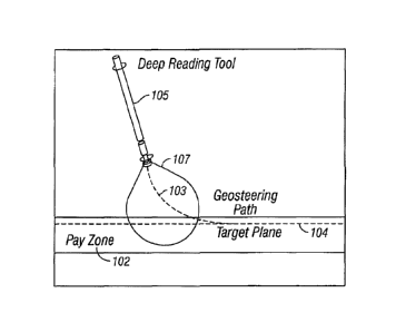
Figure 1 depicts geosteering with a deep-reading tool 105. In this case,
deep-reading tool 105 can be used with a processing unit to determine a target
payzone in real-time with minimal a-priori information, to optimally geosteer
the
well into a target zone, to minimize drilling cost and time, to make deep
readings
of formation properties, or to accomplish one or more of these tasks. The
control of the geo steering can be based on downhole logging measurements
using deep-reading tool 105 to increase the borehole's exposure to the
payzone.
Such geosteering can be used to maintain a wellbore within a region that
provides a material that is a source of economic value. Deep-reading tool 105
provides a signal having a probing region 107 that is relatively large
compared
with conventional tools. Processing the responses to probing signals provides
for geosteering along geosteering path 103 to a target plane 104 in payzone
102.
The relatively large probing region 107 allows a number of measurements to be
taken while drilling, allowing multiple course corrections to be made to take
geosteering path 103 in a locally optimal manner without, or with
significantly
reduced, overshoot in drilling.
Figure 2 shows an example embodiment of a tool structure 205 for an
electromagnetic application as a deep-reading tool. Tool structure 205
includes
transmitter sensor 212 and receiver sensors 214-1, 214-2, and 214-3 arranged
such that there is a large separation between transmitter sensor 212 and
receiver
sensors 214-1, 214-2, and 214-3 that enables the tool to look a relatively
large
distance ahead of tool structure 205. For example, tool structure 205 can be
3
= CA 02842598 2014-01-21
WO 2013/019223
PCT/US2011/046389
arranged with a large separation between transmitter sensor 212 and receiver
sensors 214-1, 214-2, and 214-3 selected to look 10 to 200 feet ahead of drill
bit
226. The example tool of Figure 2 shows tool structure 205 with transmitter
sensor 212 located on drill bit 226, while receiver sensors 214-1, 214-2, and
214-
5 3 are located on a drill collar 209 at drill-string 208. As a result,
this
configuration can maximize the transmitter-receiver spacing. The transmitters
or
receivers can be placed near the drill bit to make drilling decisions as soon
as
possible or close to the drill bit. Such placement allows a system to be able
to
look farther ahead of the drill bit. Transmitting or receiving sensors, such
as
10 transmitter antenna 212 and receiver sensors 214-1, 214-2, and 214-3,
may be
mounted outside drill collar 209, if drill collar 209 is made of conducting
material, in order to facilitate the propagation of waves. It is also possible
to
place transmitting or receiving sensors inside drill collar 209 if non-
conducting
collar material or perforations are used for drill collar 209. Transmitting
and
15 receiving sensors, such as transmitter antenna 212 and receiver sensors
214-1,
214-2, and 214-3, can include induction type sensors such as coils or
solenoids;
electrode type sensors such as rings or buttons; toroidal sensors; acoustic
type
sensors such as bender-bar, magnetostrictive or piezo-electric sensors, or
combinations thereof. Tool electronics are generally placed inside the collar.
20 Transmitting or receiving sensors can be operated at low operating
frequencies
to minimize conduction losses. However, higher frequencies may be used with
appropriate electronics to adjust for conduction losses. A tool structure as a
deep
reading sensor is not limited to example tool structure 205. Tool structure
205
can be used in a procedure identical to or similar to the geosteering in
Figure 1.
25 Figure 3 shows a block diagram of an example embodiment of a tool 301
having electronics associated with a deep-reading tool. Tool 301 includes a
system control center 332, transmitters 316-1 . . . 316-M, receivers 318-1 . .
.
318-K, transmitter and receiver antennas 313-1 . . . 313-N, a data acquisition
unit
334, a data processing unit 336, and a communication unit 338. Communication
30 unit 338 can include a telemetry unit for communication with surface
311.
System control center 332 can be configured to handle the transmission of
signals, reception of signals, and other processing operations. Transmitter
and
receiver antennas 313-1 . . . 313-N can be realized similar to or identical to
4
CA 02842598 2014-01-21
W02013/019223
PCT/US2011/046389
transmitter sensor 212 and receiver sensors 214-1, 214-2, and 214-3 of Figure
2.
In general, there are N different antennas in example tool 301, while there
are M
different transmitters and K different receivers. A switch system 331 may
facilitate the connection between antennas 313-1 . . . 313-N and transmitters
316-1 . . . 316-M and between antennas 313-1 . . . 313-N and receivers 318-1 .
. .
318-K. Transmitters and receivers may share a single antenna, where, in such a
case, the number of antennas, N, may be less than the sum of M and K. Tilted
or
multi-component antennas can be used for directional sensitivity. Rotation of
the drill string on which tool 301 or portions of tool 301 is mounted may be
utilized for further azimuthal sensitivity.
Tool 301 may operate in multiple frequencies to improve the sensitivity
of the inversion of data to the desired properties of the formation in the
direction
ahead of drilling. Data obtained from the antennas are processed in the data
processing unit 336 and sent to the system control center 332, where target
detection and geosteering decisions can be made in real time. Data can also be
communicated to surface 311 using communication unit 338, which may be
accomplished with a telemetry unit. Communication to surface 311 provides the
capability of real-time monitoring and human intervention in the geosteering
process. Alternatively, data processing may be performed at surface 31 land
system commands based on this processed data may be conveyed to system
control center 332 using communication unit 338. Such system commands can
include, but are not limit to, commands for geosteering.
Signals are acquired at one or more of receivers 318-1 . . . 318-K as a
result of transmitting signals at one or more of antennas 313-1 . . . 313-N
and
receiving signals at one or more of antennas 313-1 . . . 313-N from the
formation
layers in the region probed by the transmitted signals. The received signals
from
the formation layers depend on the properties of the formation layers and the
arrangement of antennas 313-1 . . . 313-N relative to the formation layers
probed. The signals acquired at receivers 318-1 . . . 318-K may be in the form
of
voltage signals. Voltage at receivers 318-1 . . . 318-K can be correlated as
functions of the horizontal resistivity (Rh) and vertical resistivity (Rv) of
the
formation layers, distance (d) of the tool to the target plane, dip angle (0)
between the tool axis and normal of the target plane, and azimuth (4)) of the
tool
5
CA 02842598 2014-01-21
WO 2013/019223
PCT/US2011/046389
with respect to the target plane. Additional parameters may also be considered
in more complicated formation models without any loss of generality for a
process that includes activating one or more antennas, collecting signals in
response to the activation, inverting the data from the collected signals, and
performing drilling related operations such as, but not limited to,
geosteering
based on the results of inverting the data. Herein, inverted data means the
results
of inverting data, that is, converting measured data into information
correlated to
features related to formation layers. In such a process, performing drilling
related operations, including geosteering, based on the inverted data can be
performed autonomously by operation of the tool according to a set of rules
stored in the electronics associated with the tool. For clarity purposes,
operational features of such a process can be viewed as two different
operational
modes. A first mode includes operational activities taken before the
determination of a target. A second mode includes operational activities taken
after the determination of a target.
Figure 4 shows features of an example embodiment of a method of
conducting tool operations correlated to a drilling operation before a target
is
detected. The method of Figure 4 can be performed, but is not limited to,
using
the tool of Figure 3, which may include tool structures similar or identical
to tool
structures 105 and 205 of Figures 1 and 2, respectively. The tool of Figure 3,
having multiple receiving sensors, can provide for collection of multiple data
points at one or more data acquisition points in the procedure. At 410, data
is
gathered at a log point and passed to data processing unit 336. The data may
be
provided as a matrix of different frequencies (if) and transmitter-antenna
pairs
(ii). It can also contain azimuthal bins (4) as the tool 301 rotates around
the axis
of the structure on which it is mounted. In some implementations of the
method,
log points that are close in time and space may be averaged to reduce noise.
At 420, in data processing unit 336, data can be inverted for the
parameters considered in a formation model. Inversion can be realized using a
forward model for the tool. A forward model provides a set of mathematical
relationships for sensor response that can be applied to determining what a
selected sensor would measure in a particular environment, which may include a
particular formation. A library can include information regarding various
6
CA 02842598 2014-01-21
W02013/019223
PCT/US2011/046389
formation properties that can be correlated to measured responses to selected
probe signals. Performing an inversion operation or inversion operations can
include performing an iterative process or performing a pattern matching
process. The forward model and/or library can be stored in the same machine-
readable medium device, different machine-readable media devices, or
distributed over machine-readable media system at different locations. The
instructions in the machine-readable media device or the machine-readable
media system can include instructions to perform an inversion operation or
inversion operations by performing an iterative process or performing a
pattern
matching process.
A result of inversion can be a parameter set that minimizes the error
between the measured voltage and a forward response of the forward model. A
Levenberg-Marquardt method can be used to obtain a desired set of results. The
Levenberg-Marquardt method is a standard iterative technique for addressing
non-linear least-squares problems, where the technique is used to locate the
minimum of a multivariate function that is expressed as the sum of squares of
non-linear real-valued functions. This method can be viewed as a combination
of a steepest descent method and a Gauss-Newton method. The inversion
process is not limited to using the Levenberg-Marquardt method, other
techniques may be used for inversion. For a formation model, inverted
parameters for each layer, i, can include horizontal resistivity (Rh;) and
vertical
resistivity (R) of the layer, distance (d;) to the target plane, dip angle
(0;)
between the tool axis and the normal of the target plane, and dip azimuthal
angle
(c1'
Since electronic and environmental noises can corrupt the data, and due
to sensitivity of the inversion results to noise, inverted parameters may be
quite
different from the real formation parameters. Hence, the accuracy of the
inversion can be subjected to verification before it can be used in
geosteering
decisions. In various embodiments, confidence in the inverted parameters can
be
estimated. At 430, if the data gathering operation is just initialized and if
is the
initial inversion action, the drilling operation of the well continues in its
initial
course, at 440, and a second set of data is measured at another log point, at
410.
This second data is inverted, at 420, and the results are compared to those of
the
7
CA 02842598 2014-01-21
WO 2013/019223
PCT/US2011/046389
previous inversion, at 450 to check confidence of the inverted data. Prior to
this
comparison, parameters of the previous inversion that are position dependent,
such as distance to target plane (di) and dip angle (Of), may be updated to
compensate for the well movement data acquisition points. However, this may
not be necessary if the drilling of the well moves a negligible distance
between
two log points and the change is small when compared to the threshold limits
used in comparing the two successive inversions. If the two inversions produce
results that are relatively close to each other with respect to a given
threshold,
results are deemed confident and the algorithm proceeds with analyzing the
inverted data with respect to a payzone, at 470. More than two inversion
results
may be compared. The confidence verification can include processing unit 336
configured to analyze residual errors associated with the inversion step. The
confidence verification can include comparing received voltage values. The
confidence verification can include comparing an algebraic function of the
received voltage values with respect to each received voltage value or an
estimated value. The confidence verification can include performing various
combinations of the processing discussed herein. Optimal confidence estimation
may depend on the type of noise and the type of formation being investigated.
If
the confidence in the inversion is below a set threshold, the drilling
operation
can continue its course, at 440, making another data acquisition, at 410,
which is
subjected to inversion and verification of the confidence in the newly
generated
inversion data.
At 470, once the confidence in inversion is obtained, a determination can
be made in tool 301, for example, as to whether the formation has the desired
properties based on the inverted parameters. For example, hydrocarbon content
may be the property of interest. Alternatively, other properties may be of
interest in the examination to identify underground regions to be avoided by
geosteering. If inversion result matches the desired feature, a target plane
can be
determined based on the inverted parameters. For example, in the case of a
water to oil interface, target may be set to a plane that is parallel and at a
distance to the water-oil interface inside the oil-bearing zone. If the
inverted
result does not match the desired characteristic, the well continues on its
original
course, at 440, and the above steps (410 - 470) are repeated until a desired
target
8
= CA 02842598 2014-01-21
WO 2013/019223
PCT/US2011/046389
is obtained.
When a target is determined, the drilling of the well can be steered
toward the target in an optimal course. The optimal course is defined as the
path
that minimizes the distance at which the well is parallel and in the target
plane.
5 The optimal course may at all times satisfy a dogleg criteria, which puts
a limit
on the maximum angle that can be produced in a given distance. Typical dogleg
paths are around 100 per 100 feet. This number may vary significantly based on
available technology and properties of the formation. In the case of the above
two conditions, calculation of this optimal course involves solution of a
10 geometric problem involving circles and lines, which is straight forward
and as a
result is not included here. However, in different geosteering conditions, a
different optimum course calculation may be used, which can involve an
iterative solution.
Figure 5 shows features of an embodiment of an example method of
15 conducting drilling operations after a target is detected. As discussed
above with
respect to Figure 4, starting, at 501, as the well is steered toward the
target at
505, position dependent parameters of the inversion are updated, at 515. At
525,
a data estimate at the next log point, based on these updated parameters, can
be
generated using a forward model, for example generating a voltage estimate,
20 Vestimate. After generation of the data estimate, data acquisition can
be
performed, at 535, followed by inversion, at 555, using the acquired data.
Since
inversion may involve a large number of parameters, it may take considerable
amount of processor time and may not be feasible to perform at every log point
in a downhole data processing unit or a surface data processing unit. In order
to
25 minimize the number of time-consuming inversion operations, necessity of
inversion can be tested at each step. At 545, if the measured data is close to
the
estimate of 525, the previous inversion result is deemed accurate and no
inversion is performed. After the data is inverted, at 565, the confidence of
results of this new inversion is tested. This confidence calculation is
similar to
30 that discussed with respect to Figure 4. If confidence is not satisfied,
the
steering continues toward the target and the data acquisition and processing
continues. If confidence is satisfied, determined parameter estimates are
added
to a target list, at 585. Then, at 595, each item in this list is ranked
(assigned
9
= CA 02842598 2014-01-21
WO 2013/019223
PCT/US2011/046389
points) or re-ranked to determine the one that may be the most accurate.
Figure 6 shows features of an example embodiment of a method of using
ranking of a target list 610 to direct geosteering. Multiple data acquisitions
can
be conducted at a log point or within a short distance of the log point using
5 multiple receiving sensors identical to or similar to the receiving
sensors of
Figure 2. At 620, the list of possible targets can be sorted in order of the
time
they are obtained. Newer estimates are given higher weights, since errors in
target location for older estimates are generally higher. Typically, the only
exception is the overshoot situation where older estimates may be more
accurate
10 than the newer ones. At 630, using the forward model, elements of the
list that
produce values that are closer to the measured data are given higher weights.
At
640, estimates can also be sorted according to their distance to the rest of
the
estimates. A mean or median of the estimates may be used for this purpose.
Higher weights are given to the estimates that are closer to the average
values.
15 Thus, this procedure can be used to eliminate outlier estimates. The
target list
may be ranked according to how well the inverted parameters predict the
measured data. At 650, results of these different steps (620, 630, and 640)
can
be combined and the element of the list with the highest overall weight can be
chosen as the best target estimate. The order of the activities 620, 630, and
640
20 can be conducted in any order. In various embodiments, the ranking
algorithm
may include a subset of activities 620, 630, and 640 without performing all
activities 620, 630, and 640. Additional procedures for optimization of the
ranking algorithm can be conducted.
After the ranking of the items in the target list, the well can be steered
25 toward the location of the target estimate that is deemed most accurate.
If no
inversion is performed, the well can be steered towards the target used in the
previous step. The target list can be updated to account for the change in
tool's
position, that is, updated values for the distance to the target d1s, dip
angle Ois and
dip azimuthal angle (I) is are calculated for the model. After the updating is
30 completed, the above processing activities can be repeated until the
well is
placed in the target plane. The well may be steered after it reaches the
target
plane using the above processing activities to ensure that the well does not
deviate from its path and stays within the payzone. The combination of the
CA 02842598 2014-01-21
WO 2013/019223
PCT/US2011/046389
acquisition tool structure and the processing of the acquired data can provide
for
functioning as a proactive steering tool. Even though the target is described
herein as a plane, it may consist of other shapes and data processing in
accordance with the teachings herein, can be straightforwardly extended to
targets having shapes other than a plane.
In various embodiments, a method is provided that is capable of
detecting a target payzone in real-time by calculating an optimal path to a
target
and landing the well to the desired target zone with minimum drilling time.
Such a procedure is cost effective since it does not require any auxiliary
information from reference wells, or any prior intersection with the target
well.
As a result, this procedure can decrease the total drilling distance and time
by
eliminating or minimizing the overshoot of the target location. Reductions in
the
overshoot by at least 100 feet may be obtained. The method can be applied
where the well is deviated.
Figure 7 shows an example formation geometry used in the simulations
of a deep-reading tool. The higher depth of investigation of deep-reading tool
705, having a configuration similar to or identical to deep-reading tool 105
of
Figure 1 and/or similar to or identical to deep-reading tool 205 of Figure 2,
can
be illustrated by comparing simulation results with an electromagnetic tool
having a lower depth of investigation that is in contemporary use. To
accomplish this, a deep-reading tool 705 with a much longer transmitter-
receiver
spacing can be compared with an azimuthal deep resistivity (ADR) tool. The
depth axis is in the direction of the true vertical with respect to earth,
increasing
downward. The well is taken to be inside an isotropic resistive layer 733 with
a
resistivity of 20 0-m, and it is being drilled towards an interface 739 to a
less
resistive layer 737. This second layer 737 is also isotropic with a
resistivity of 1
-m. For illustration purposes, a target plane is chosen at 5 ft away from the
boundary, inside the resistive layer 733 at a depth of 1160 ft. Tool 705 can
be
represented by a tool model having a transmitter with a magnetic moment
parallel to its tool axis and located on the drill bit. There are three
receiver
antennas in the model, similar to Figure 2. All three receiver antennas are
tilted
at an angle of 45 and they are at a distance of 25 ft., 37.5 ft., and 50 ft.
from the
transmitter, respectively. This tool model was selected as a multi-frequency
11
CA 02842598 2014-01-21
W02013/019223
PCT/US2011/046389
system operating at the frequencies of 500 Hz, 2 kHz, 6 kHz, and 18 kHz. Dip
azimuth angle was taken as 150. Simulations started with the transmitter at
1000
ft. Maximum geosteering rate of the tools was taken as 100 deviation in 100
ft.
Relative dielectric permittivity and relative magnetic permeability of the
media
of layers 733 and 737 were taken as unity. A multiplicative noise with uniform
distribution was added to the signal in the simulations. Peak value of the
noise is
selected to be 0.5% of that of the signal.
Figure 8 shows, for well trajectories of thirty degrees, a comparison of
results from an ADR tool with results from a deep-reading tool. In the
simulation, well trajectories of thirty degrees means that the initial dip
angle was
taken as 0 = 30 . The abovementioned method discussed with respect to Figures
4-6 was applied to both the well with the ADR tool and the well with the deep-
reading tool. Simulations were repeated 10 times for both cases to account for
the randomness of the noise. Results show that the method can be successfully
used for landing on the target plane with a traditional tool like an ADR tool,
but
the greatest benefit is observed when using a deep-reading tool. On average,
the
deep-reading tool begins to see the target zone at a distance of 140 ft. from
the
boundary, compared to approximately 20 ft. for that of the ADR tool. As a
result, overshoot is decreased by about 120 ft. and the total horizontal
drilling
distance is reduced by approximately 500 ft.
Figure 9 shows, for well trajectories of initial dip angle equal to sixty
degrees, a comparison of results from an azimuthal deep resistivity tool with
results from a deep-reading tool. The method discussed with respect to Figures
4-6 was again applied. Such a method is able to geosteer the well with the
deep-
reading tool to the target zone with little or no overshoot, while the well
with the
ADR tool overshoots the target by approximately 70 ft on average and total
horizontal drilling distance is increased by approximately 350 ft. Results of
the
simulations demonstrate that the method, as taught herein, can be successfully
applied to detect a target zone in real time with no a-priori information,
that
geosteering to the target zone and horizontal placement of the wells can be
successfully performed, and that the method is most beneficial when it is
applied
using a tool with a high depth of investigation. At a high depth of
investigation,
the well may be geosteered to the payzone with little or no overshoot. As a
12
CA 02842598 2014-01-21
W02013/019223
PCT/US2011/046389
result, drilling time and costs are minimized.
Figure 10 shows features of an embodiment of an example method of
landing a well in a target zone. At 1010, a transmitter sensor on a tool
structure
arranged relative to a drill bit in a well is activated. At 1020, a signal is
acquired
in a receiver sensor of the tool structure in response to activation of the
transmitter sensor. The receiver sensor can be set apart from the transmitter
sensor by a separation distance sufficiently large to provide real time
processing
of the signal before reaching a boundary of a target zone in a drilling
operation.
This separation distance allows a probe signal be generated from the
transmitter
sensor ahead of a drill bit and signals from the formation generated in
response
to the probe signal to be collected and processed such that course corrections
to
the drilling can be made during the drilling process. Additional receiver
sensors
can be arranged on the tool structure with the transmitter sensor set apart
from
the transmitter by a separation distance that is sufficiently large to provide
real
time processing of the signal before reaching a boundary of a target zone in a
drilling operation. The transmitter sensor or sensors and the receiver sensor
or
sensors can be arranged along axis of the tool structure similar to or
identical to
an embodiment of such a tool structure disclosed herein.
At 1030, the signal is processed. The processing can include generating
data corresponding to formation properties ahead of the drill bit and
monitoring
the generated data. The processing can be conducted in real time during a
drilling operation. Generating data corresponding to formation properties can
include conducting an inversion operation with respect to the acquired signal.
The results of the inversion operation can include one or more of a horizontal
resistivity of a formation layer, a vertical resistivity of the formation
layer, a
distance of the drill bit to the target, a dip angle between an axis of the
tool
structure and a normal to the target, or an azimuth of the tool structure with
respect to the target. The results of the inversion can be verified such that
verifying accuracy of results of the inversion operation is conducted before
using
the results of the inversion operation to geosteer the well. An example
verification process may include comparing the results of two inversion
operations such that the difference between the two inversion operations being
less than a set threshold value indicates a confidence level to continue along
a
13
CA 02842598 2014-01-21
WO 2013/019223
PCT/US2011/046389
path to the target.
The inversion operation can be conducted by applying a Levenberg-
Marquardt technique with respect to the acquired signal. Other techniques can
be implemented. Conducting the inversion operation can include generating a
parameter set that minimizes error between measured voltage and a forward
response of a forward model. The measured voltage corresponds to a received
signal at a receiver sensor of the tool structure generated ahead of a drill
bit in
response to a signal sent from a transmitter sensor of the tool structure. A
parameter set can be generated at each logging point of the drilling operation
or
at less than each logging point depending on the difference between received
signals at consecutive logging points. The process of landing a well at a
target in
a target zone can be conducted in an iterative manner with the target and
target
zone predetermined. Alternatively, the process can include iteratively
controlling activation of the transmitter sensor, acquiring a signal
corresponding
to the activation, and processing the acquired signal to identify the target
or the
target payzone. The identification process can include comparing the results
of
the inversion process with properties of a desired target zone that are stored
in
memory. The use of the transmitter sensors and receiver sensors set apart as
deep-reading sensors provides a capability to identify regions to avoid in the
identified target zone and to set a target in the target zone that avoids such
regions.
At 1040, the well is geosteered based on monitoring the generated data.
In various embodiments, monitoring the generated data can include comparing
the generated data with previously generated data. The geosteering of the well
can be based on comparing the generated data with previously generated data.
The geosteering can direct the drilling of the well such that the well
approaches a
target in the target zone with minimal or no overshoot of the target zone.
Geosteering the well includes directing drilling of the well to the target
identified
as a target plane in the target zone. The target is not limited to a target
plane, the
target may have other shapes. The shape may depend on structures in the
formation layers of the target zone that are to be intentionally avoided. The
geosteering may be conducted along a course according to a dogleg criteria.
Various dogleg criteria can be set. For example, the dogleg criteria may
include
14
CA 02842598 2014-01-21
WO 2013/019223
PCT/US2011/046389
a maximum angle of around 10* per 100 feet.
The geosteering process using deep-reading sensors can be conducted in
an iterative manner in which optional activities can be conducted during an
iteration. For example, the process can include skipping an inversion activity
in
an iteration. The procedure, with the inversion skipping option, can include
repeating controlling activation of the transmitter sensor, acquiring a signal
corresponding to the activation, processing the acquired signal to generate
inverted data, and geosteering the well in an iteration process such that the
iteration process provides for detection of the target or geosteering to the
target.
The procedure can include generating, for a next signal to be acquired, an
estimated signal value from processing a last signal processed. The next
signal
can be acquired and a measured signal value of the next signal can be
generated.
If a difference between the estimated signal value and the measured signal
value
is within a threshold value, the data processing unit can refrain from
processing,
for example inverting, this acquired next signal and accept the inverted data
generated from the last signal processed as accurate. Generating the estimated
signal value for the next signal to be acquired can include using a forward
model. The forward model used can be the forward model used in the inversion
operation to generate the inverted data from the last signal.
In various embodiments, a method to land a well directed to a target in a
target zone can also include repeating controlling activation of the
transmitter
sensor and acquiring a signal corresponding to the activation at different log
points during drilling the well; performing a confidence process on inverted
data
generated from acquired signals correlated to one or more of the log points;
adding, to a target list, inverted data that satisfied the confidence process
or
parameters generated from the inverted data that satisfied the confidence
process; ranking the target list; and geosteering toward the target based on
the
ranked target list. In an iterative process, ranking elements of the target
list can
include re-ranking elements of the target list based on updated parameters.
Ranking the target list can include sorting the target list with respect to
the time
that the inverted data is generated. Sorting the target list with respect to
time can
include applying weights to the elements of the target list such that higher
weights are applied to most recently generated inverted data. Ranking the
target
CA 02842598 2014-01-21
WO 2013/019223
PCT/US2011/046389
list can include computing forward responses for a number of target models and
applying weights according to a difference between each forward response and
its corresponding measured response such that, the smaller the difference, the
higher is the weight assigned. Ranking the target list includes calculating
average values of the inverted data in the target list, and applying weights
to the
inverted data according to a difference between the inverted data in the
target list
and the average values of the inverted data such that, the smaller the
difference,
the higher is the weight assigned.
Ranking a target list can include combining one or more different ranking
procedures using generated weights in these procedures. For example, ranking
the target list can include sorting the target list with respect to the time
that the
inverted data is generated and applying a time weight such that a higher time
weight is given to most recently generated inverted data; computing forward
responses for a number of target models and applying response weights
according to a difference between each forward response and its corresponding
measured response such that, the smaller the difference, the higher is the
response weight assigned; and calculating average values of the inverted data
in
the target list and applying averaged value weights to the inverted data
according
to a difference between the inverted data in the target list and the average
values
of the inverted data such that, the smaller the difference, the higher is the
averaged value weight assigned. The time weight, the response weight, and the
averaged value weight can be added for each element in the target list to
determine a model from which to geosteer. In addition, after reaching the
target,
where the target has a shape in the target zone, the method of geosteering can
include repeating controlling activation of the transmitter sensor and
acquiring a
signal corresponding to the activation at different log points during drilling
the
well; performing a confidence process on inverted data generated from acquired
signals correlated to one or more of the log points; and geosteering the well
along the shape of the target.
Figure 11 shows a block diagram of an embodiment of an apparatus 1100
to land a well directed to a target in a target zone using deep-reading
sensors.
Apparatus 1100 includes a tool structure 1105 having an arrangement of sensors
1113-1, 1113-2 . . . 1113-(N-1), 1113-N along a longitudinal axis 1107 of tool
16
CA 02842598 2014-01-21
WO 2013/019223
PCT/US2011/046389
1105. Each sensor 1113-1, 1113-2 . . . 1113-(N-1), 1113-N can be utilized as a
transmitting sensor or a receiving sensor under the control of control unit
1132.
Control unit 1132 is operable to select one or more transmitter sensors from
among the sensors in the arrangement of sensors 1113-1, 1113-2. . . 1113-(N-
1),
1113-N and to select one or more receiver sensors from among the sensors in
the
arrangement of sensors 1113-1, 1113-2 . . . 1113-(N-1), 1113-N such that the
selected receiver sensor is set apart from the selected transmitter sensor by
a
separation distance that is sufficiently large to enable a signal acquired at
the
selected receiver sensor, in response to activating the selected transmitter
sensor,
to be processed in real time during a drilling operation before the well
reaches
the boundary of a target zone. The arrangement of sensors 1113-1, 1113-2 . . .
1113-(N-1), 1113-N include, but is not limited to, an arrangement of tilted
antennas. For arrangements in which sensors 1113-1, 1113-2. . . 1113-(N-1),
1113-N are tilted, each tilted sensor can be arranged with respect to
longitudinal
axis 1117. However, sensors 1113-1, 1113-2 . . . 1113-(N-1), 1113-N can be
arranged other than with respect to longitudinal axis 1117. Having a large
separation distance between selected transmitting sensor and selected receiver
sensor allows for collection of formation data far ahead of the drilling
operation.
For a given separation distance, the deep-reading distance is largest for a
transmitting sensor disposed on the drill bit for the drilling operation.
Sensors
1113-1, 1113-2 . . . 1113-(N-1), 1113-N and the arrangement of sensors 1113-1,
1113-2 . . . 1113-(N-1), 1113-N can be realized, for example, similar or
identical
to the sensors and the deep-reading arrangement associated with Figures 1-10,
12, and 13. Sensors 1113-1, 1113-2. . . 1113-(N-1), 1113-N and the
arrangement of sensors 1113-1, 1113-2 . . . 1113-(N-1), 1113-N can be
implemented in measurements-while-drilling (MWD) applications such as a
logging-while-drilling (LWD) applications.
Apparatus 1100 can include a control unit 1132 that manages the
generation of transmission signals and the collection of received signals
corresponding to the transmission signals. The generation of transmission
signals can be conducted to provide signals of different frequencies. The
collected received signals can be provided to a data processing unit 1136 in
appropriate format to perform inversion on data generated from signals
acquired
17
CA 02842598 2014-01-21
WO 2013/019223
PCT/US2011/046389
at receiving antennas in the arrangement of sensors 1113-1, 1113-2 . . . 1113-
(N-
1), 1113-N. Data processing unit 1136 can be structured to utilize a forward
model to perform the inversion on data generated from signals acquired at
receiving antennas. Data processing unit 1136 can be structured to provide
formation properties and data identifying the position of the drilling
operation,
which can be correlated to the position of the drill bit, relative to a target
in a
target zone for drilling using iterative processing. Pattern matching
processes
may also be employed. Data processing unit 1136 can be arranged as a separate
unit from control unit 1132 or integrated with control unit 1132. Control unit
1132 and data processing unit can be realized, for example, similar or
identical
to the control units and data processing units associated with Figures 1-10,
12,
and 13.
Various components of a system including a tool, having one or more
sensors operable with transmitting positions and receiving positions separated
by
relatively large distances, and a processing unit, as described herein or in a
similar manner, can be realized in combinations of hardware and software based
implementations. These implementations may include a machine-readable
storage device having machine-executable instructions, such as a computer-
readable storage device having computer-executable instructions, to control
activation of a transmitter sensor on a tool structure arranged relative to a
drill
bit in a well; acquire a signal in a receiver sensor of the tool structure in
response
to activation of the transmitter sensor, where the receiver sensor is set
apart from
the transmitter sensor by a separation distance sufficiently large to provide
real
time processing of the signal before reaching a boundary of a target zone;
process the signal including generating data corresponding to formation
properties ahead of the drill bit and monitoring the generated data; and
geosteer
the well based on monitoring the generated data such that the well approaches
a
target in the target zone with minimal or no overshoot of the target zone. The
instructions can include instructions to operate a tool and a geosteering
operation
in accordance with the teachings herein. Further, a machine-readable storage
device, herein, is a physical device that stores data represented by physical
structure within the device. Examples of machine-readable storage devices
include, but are not limited to, read only memory (ROM), random access
18
CA 02842598 2014-01-21
WO 2013/019223
PCT/US2011/046389
memory (RAM), a magnetic disk storage device, an optical storage device, a
flash memory, and other electronic, magnetic, and/or optical memory devices.
Figure 12 depicts a block diagram of features of an example embodiment
of a system 1200 having a tool structure 1205 configured with sensors arranged
such that a transmitting sensor is set apart from a receiving sensor by a
separation distance that is sufficiently large to provide real time processing
of a
signal received in response to a transmitted probe signal before reaching a
boundary of a target zone in a drilling operation. System 1200 includes tool
structure 1205 having an arrangement of transmitter sensors 1212 and receiver
sensors 1214 that can be realized in a similar or identical manner to
arrangements of sensors discussed herein. System 1200 can be configured to
operate in accordance with the teachings herein.
System 1200 can include a controller 1201, a memory 1225, an electronic
apparatus 1235, and a communications unit 1238. Controller 1201, memory
1225, and communications unit 1238 can be arranged to operate as a processing
unit to control operation of tool structure 1205 having an arrangement of
transmitter sensors 1212 and receiver sensors 1214 and to perform one or more
inversion operations on the signals collected by tool structure 1205 to
geosteer a
well directed to a target in a target zone in a manner similar or identical to
the
procedures discussed herein. A data processing unit 1236, to engage in
analysis
of data to verify measurements and provide indications used to make course
corrections to geosteer to the well, can be implemented as a single unit or
distributed among the components of system 1200 including electronic apparatus
1235. Controller 1201 and memory 1225 can operate to control activation of
transmitter sensors 1212 and selection of receiver sensors 1214 in tool
structure
1205 and to manage processing schemes in accordance with measurement
procedures and signal processing as described herein. A data acquisition unit
1234 can be structured to collect signals received at receiver sensors 1214 in
response to probe signals generated by transmitter sensors 1212. Data
acquisition unit 1234 can be implemented as a single unit or distributed among
the components of system 1200 including electronic apparatus 1235. Data
acquisition unit 1234, data processing unit 1236, and/or other components of
system 1200 can be configured, for example, to operate similar to or identical
to
19
CA 02842598 2014-01-21
WO 2013/019223
PCT/US2011/046389
the components of tool 301 of Figure 3 and/or similar to or identical to any
of
methods corresponding to Figures 4-6 and 10.
Communications unit 1238 can include downhole communications for
appropriately located sensors. Such downhole communications can include a
telemetry system. Communications unit 1238 may use combinations of wired
communication technologies and wireless technologies at frequencies that do
not
interfere with on-going measurements.
System 1200 can also include a bus 1217, where bus 1217 provides
electrical conductivity among the components of system 1200. Bus 1217 can
include an address bus, a data bus, and a control bus, each independently
configured or in an integrated format. Bus 1217 can be realized using a number
of different communication mediums that allows for the distribution of
components of system 1200. Use of bus 1217 can be regulated by controller
1201.
In various embodiments, peripheral devices 1245 can include displays,
additional storage memory, and/or other control devices that may operate in
conjunction with controller 1201 and/or memory 1225. In an embodiment,
controller 1201 is realized as a processor or a group of processors that may
operate independently depending on an assigned function. Peripheral devices
1245 can be arranged with a display, as a distributed component on the
surface,
that can be used with instructions stored in memory 1225 to implement a user
interface to monitor the operation of tool 1205 and/or components distributed
within system 1200. The user interface can be used to input parameter values
for
thresholds such that system 1200 can operate autonomously substantially
without user intervention. The user interface can also provide for manual
override and change of control of system 1200 to a user. Such a user interface
can be operated in conjunction with communications unit 1238 and bus 1217.
Figure 13 depicts an embodiment of a system 1300 at a drilling site,
where system 1300 includes a tool 1305 configured with an arrangement of
sensors such that receiver sensors are set apart from corresponding
transmitter
sensors by a separation distance that is sufficiently large to provide real
time
processing of a signal received in response to a transmitted probe signal
before
reaching a boundary of a target zone in a drilling operation. System 1300
CA 02842598 2014-01-21
WO 2013/019223
PCT/US2011/046389
includes tool 1305 having arrangements of transmitters and receivers that can
be
realized in a similar or identical manner to arrangements discussed herein to
attain deep reading ahead of drill bit 1326. Tool 1305 can be structured and
fabricated in accordance with various embodiments as taught herein with
respect
to a sensor tool having an arrangement of transmitters and receivers. For
example, a transmitter sensor of tool 1305 can be disposed on drilled bit 1326
with one or more receivers on drill collars 1309 in a manner similar to or
identical to the arrangement of transmitter sensor 212 on drill bit 226 and
receiver sensors 214-1, 214-2, and 214-3 on drill collar 209 of Figure 2.
System 1300 can include a drilling rig 1302 located at a surface 1311 of a
well 1306 and a string of drill pipes, that is, drill string 1308, connected
together
so as to form a drilling string that is lowered through a rotary table 1307
into a
wellbore or borehole 1312. The drilling rig 1302 can provide support for drill
string 1308. The drill string 1308 can operate to penetrate rotary table 1307
for
drilling a borehole 1312 through subsurface formations 1314. The drill string
1308 can include drill pipe 1319 and a bottom hole assembly 1320 located at
the
lower portion of the drill pipe 1319.
The bottom hole assembly 1320 can include drill collar 1309, tool 1305
attached to drill collar 1309, and a drill bit 1326. The drill bit 1326 can
operate
to create a borehole 1312 by penetrating the surface 1311 and subsurface
formations 1314. Tool 1305 can be structured for an implementation in the
borehole of a well as a MWD system such as a LWD system. The housing
containing tool 1305 can include electronics to activate transmitters of tool
1305
and collect responses from receivers of tool 1305. Such electronics can
include
a processing unit to analyze signals sensed by tool 1305 and provide
measurement results to the surface over a standard communication mechanism
for operating a well. Alternatively, electronics can include a communications
interface to provide signals sensed by tool 1305 to the surface over a
standard
communication mechanism for operating a well, where these sensed signals can
be analyzed at a processing unit at the surface.
During drilling operations, the drill string 1308 can be rotated by the
rotary table 1307. In addition to, or alternatively, the bottom hole assembly
1320 can also be rotated by a motor (e.g., a mud motor) that is located
downhole.
21
CA 02842598 2014-01-21
WO 2013/019223
PCT/US2011/046389
The drill collars 1309 can be used to add weight to the drill bit 1326. The
drill
collars 1309 also can stiffen the bottom hole assembly 1320 to allow the
bottom
hole assembly 1320 to transfer the added weight to the drill bit 1326, and in
turn,
assist the drill bit 1326 in penetrating the surface 1311 and subsurface
formations 1314.
During drilling operations, a mud pump 1332 can pump drilling fluid
(sometimes known by those of skill in the art as "drilling mud") from a mud
pit
1334 through a hose 1336 into the drill pipe 1319 and down to the drill bit
1326.
The drilling fluid can flow out from the drill bit 1326 and be returned to the
surface 1311 through an annular area 1340 between the drill pipe 1319 and the
sides of the borehole 1312. The drilling fluid may then be returned to the mud
pit 1334, where such fluid is filtered. In some embodiments, the drilling
fluid
can be used to cool the drill bit 1326, as well as to provide lubrication for
the
drill bit 1326 during drilling operations. Additionally, the drilling fluid
may be
used to remove subsurface formation 1314 cuttings created by operating the
drill
bit 1326.
In various embodiments, a method utilizes deep-reading sensors to
optimally land a well to a payzone with minimal or no overshoot. This method
can minimize drilling cost and time. Further, such a method can keep the well
in
a target zone and can perform deep measurements of formation properties.
Although specific embodiments have been illustrated and described
herein, it will be appreciated by those of ordinary skill in the art that any
arrangement that is calculated to achieve the same purpose may be substituted
for the specific embodiments shown. Various embodiments use permutations
and/or combinations of embodiments described herein. It is to be understood
that the above description is intended to be illustrative, and not
restrictive, and
that the phraseology or terminology employed herein is for the purpose of
description. Combinations of the above embodiments and other embodiments
will be apparent to those of skill in the art upon studying the above
description.
22