Note: Descriptions are shown in the official language in which they were submitted.
CA 02849315 2014-03-20
WO 2013/053012
PCT/AU2012/001237
1
SAFETY BUOY
FIELD OF THE INVENTION
The invention relates to marine safety, and relates more particularly to
water safety equipment used at surf beaches and other marine environments
such as coastal estuaries.
BACKGROUND OF THE INVENTION
Australia has many surf beaches, and in the early 1900's various surf
lifesaving clubs and organisations formed to promote safety at surf beaches.
Popular surf beaches have been patrolled by lifesavers or lifeguards ever
since.
Surf lifesaving equipment has changed considerably over the years. Surf
rescues
were once performed with a surf reel, or a surf boat, with both techniques
requiring considerable strength and conditioning as well as a small crew of
able
lifesavers. These techniques are now historical for rescue purposes. Equipment
that is currently favoured includes rescue tubes, rescue boards, inflatable
rescue
boats (IRBs) and jet skis. Helicopters may also be used when necessary and
available, but widespread use is prohibitive due to their expense.
As is apparent, surf beaches present a considerable public safety
challenge, particularly when frequented by those not familiar or confident
with surf
conditions. Due to the complexity of the surf environment, the approach of
lifesavers and the accompanying public safety message has for many years been
to direct bathers to swim "between the flags". A pair of distinctive red and
yellow
flags are positioned along the shoreline according to prevailing conditions to
indicate an interval of the beach that is considered safe for bathing. Bathers
are
directed to swim between the flags for their own safety, and also to contain
the
area of beach that is more actively patrolled.
Despite the success of this approach, it is not without its limitations.
Popular beaches tend to attract beachgoers having a wide diversity of surf
experience and skills. Those lacking familiarity and confidence with surf
conditions may not be aware of the importance of bathing only in designated
areas and can often be drawn to calmer waters that lack breaking surf and thus
appear safer. Unfortunately, these areas quite often harbour rip currents that
can
quickly find unsuspecting bathers out of their depth. This is disconcerting
for
CA 02849315 2014-03-20
WO 2013/053012
PCT/AU2012/001237
2
those unable to swim well, and can be quite distressing for those unable to
swim
at all.
Many surf beaches are in fact prone to developing rip currents. Rip
currents develop as a natural consequence of water flowing back out to sea
after
flowing into shore. Rip currents can vary in position, strength and direction
and
depend on local conditions. Rips may be permanent owing to the structure of
the
beach and marine surrounds, and any man-made structures. For example, rock
formations, breakwaters, drainage channels and boat ramps may all contribute
to
permanent rip currents. Rip currents may also be temporary depending upon tide
levels, and prevailing sand formations and winds.
Those experienced with reading surf conditions can identify rip currents
due to various tell-tale signs. Typically a rip current shows no breaking
surf.
Instead, the area may be murky due to agitated sand beneath the water's
surface, and sea foam and debris may be seen floating seawards. If there is
large
breaking surf nearby, the rip area more typically has a smoother surface with
much smaller undulating waves. The water in a rip current area may also appear
darker due to the water being deeper due to the absence of a sandbank. Rip
currents typically flow out to sea, but can also flow along a beach. While rip
currents occur predominantly at surf beaches, other marine environments such
as
coastal estuaries can also harbour dangerous currents.
While many improvements have been made to the working methods and
safety equipment used by lifesavers over the years, significant effort and
attention
is required by lifesavers to rescue beachgoers caught in dangerous currents.
This
diverts attention from other beachgoers who may require assistance.
Notwithstanding the efforts of lifesavers, a significant number of beachgoers
drown every year in Australia, in the order of typically one drowning every
two or
three days.
A recent attempt at improved beach safety is published as US
2011/0207377, 25 August 2011, in the name of Frederick William George, of
Hawthorne, Queensland. Mr George envisions, in a typical configuration, a
triangulated arrangement between spaced apart beach flags ¨ conventionally
indicating a safe bathing area ¨ and floating lines that extend into the sea
from
the flags and meet at a safety buoy at a comparable distance out to sea. An
CA 02849315 2014-03-20
WO 2013/053012
PCT/AU2012/001237
3
advantage of this system is that bathers have a floating line to hold if
distressed,
and the safe bathing area is more emphatically demarcated for the benefit of
beachgoers.
Similarly, another recent publication describes a marine safety buoy,
namely AU 2010100100, published 4 March 2010, in the name of Andrew David
Curren, of Fadden, Australian Capital Territory. Mr Curren proposes using ¨
moored in rip current areas ¨ a buoy having suitable warning indicia. Mr
Curren
also contemplates using in the buoy some form of distress button and alert
system for the benefit of distressed swimmers.
While the foregoing attempts represent contributions to the art of marine
safety, the arrangements described are not the applicant's knowledge presently
deployed in marine environments. Any further improvements in marine safety
having practical and pragmatic application are accordingly welcome in view of
the
abovedescribed dangers of rip current areas.
SUMMARY OF THE INVENTION
The inventive concept of the present invention resides in recognition that a
safety buoy for a rip current area can be provided with a shape which is
generally
buoyant and stable under typical marine conditions, and more particularly
outgoing rip currents and incoming swell conditions, and which can be moored
in
a rip current area to indicate the presence and direction of a rip current,
and
provide a resting platform nearby bathers requiring assistance.
Existing safety buoys are overwhelmingly of a generally circularly or
rotationally symmetric configuration, or at least substantially so, and while
they
may be used to effectively mark a dangerous rip area, such buoys are unsuited
for the purposes and fail to secure the advantages of the safety buoy
described
herein.
A safety buoy for use in a rip current area comprises a bow, a stern and a
hull, the bow having a streamlined prow and the stern having an open decked
area above the hull, so that the safety buoy can be moored such that the
streamlined prow generally faces seaward towards an incoming swell, and the
open decked area generally faces shoreward towards an outgoing rip current,
the
open decked area thereby providing a resting platform for bathers caught in
the
rip current area.
CA 02849315 2014-03-20
WO 2013/053012
PCT/AU2012/001237
4
The safety buoy described herein is of a generally longitudinal shape and
streamlined prow and a wider stern having an open decked area. When
positioned in a rip, the buoy is preferably moored fore and aft, with its bow
facing
generally seaward into oncoming swell, and its stern facing generally
shoreward.
The open decked area, facing generally shoreward, enabling bathers caught in a
rip current to avail themselves of a resting platform which allows them to
avoid
being carried further by the rip.
The buoy desirably features a removably attachable trailing lifeline
supported on the water surface by floats positioned at intervals along the
length
of the lifeline. The trailing lifeline indicates the direction of the
prevailing rip
current and also increases an area which bathers caught in the rip current may
target to reach the safety of the buoy. Bathers reaching the trailing lifeline
can pull
themselves against the rip towards the deck area of the buoy.
Other desirable features of the buoy include a navigational light or strobe
unit and a emergency radio beacon able to communicate with an emergency
radio network. The strobe unit and radio beacon desirably operate under
control
of an electronic control unit that co-ordinates operation of the strobe unit
and
radio beacon according to predetermined settings in concert with a manual
switch. Power is supplied by a solar power unit connected to the electronic
control
unit. Strobe units and emergency radio beacons are especially desirable for
incorporation in buoys that are moored permanently in rip currents at
particularly
popular or hazardous locations. Buoys without such electronic equipment are
better suited for temporary or day-by-day use in temporary rips.
The buoy can be positioned by a mooring block or anchor via a mooring
chain. A mooring weight may also be used. The buoy preferably has a mooring
points positioned fore and aft to allow the buoy to remain safely moored or
anchored in large swells and strong currents.
A detailed, preferred embodiment of the present invention will be described
in the following with reference to the accompanying drawings.
DESCRIPTION OF DRAWINGS
Fig. 1 is an aerial view in schematic form of a beach having a rip current
area in which there is moored a safety buoy having a trailing lifeline in
accordance with the present invention.
CA 02849315 2014-03-20
WO 2013/053012
PCT/AU2012/001237
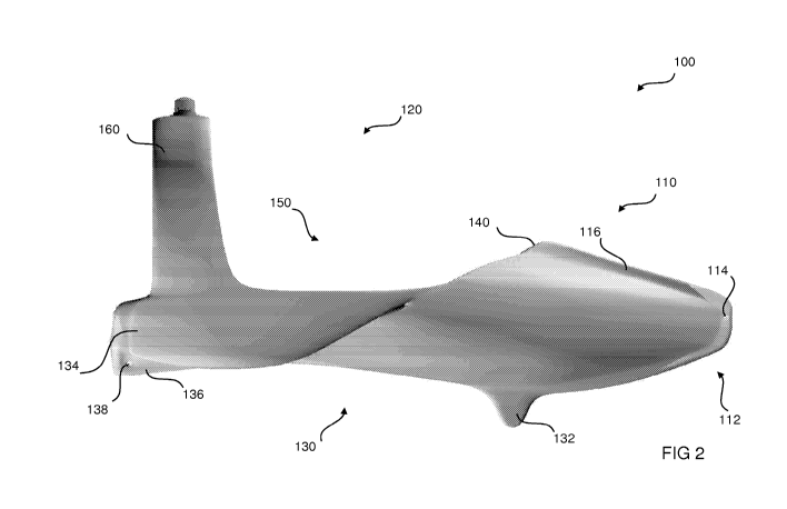
Fig. 2 is an elevation of the safety buoy depicted in Fig. 1.
Fig. 3 is a plan view the safety buoy of Fig. 1.
Fig. 4 is a view of the underside of the safety buoy of Fig. 1.
Fig. 5 is a front elevation of the safety buoy of Fig. 1.
5 Fig. 6 is a rear elevation of the safety buoy of Fig. 1.
Fig. 7 is a perspective view of the safety buoy of Fig. 1, from a top rear
aspect.
Fig. 8 is a perspective view of the safety buoy of Fig. 1, from a front
underside aspect.
Fig. 9 is a schematic view of circuitry incorporated in a safety buoy fitted
with an emergency radio beacon.
DESCRIPTION OF PREFERRED EMBODIMENTS
A safety buoy 100 is of assistance as lifesaving equipment for use in rip
current areas. This may include ocean and estuary areas where there are rips
or
strong tidal flows. The safety buoy 100 can advantageously be moored within
the
general vicinity a rip current running in a rip current area, and used by
those in
the water if caught and swept up in the rip current.
Fig. 1 illustrates an aerial schematic view of an ocean 10 breaking at a
beach 20. Sandbars 30, 30' have formed a short distance from the shoreline of
the beach 20. As is usual, there are waves breaking in the region of the
sandbars
30, 30', as indicated by the arrows 40, 40' positioned over the sandbars 30,
30'.
Between the sandbars 30, 30' there is a rip current 50 returning out to sea as
indicated.
Located generally between the sandbars 30, 30' is a rip current area 35,
where a safety buoy 100 can be secured in place by a mooring arrangement,
which is below the waterline and not shown. Trailing behind the safety buoy
100
is a lifeline 170. The lifeline 170 is supported along its length by floats
172. The
lifeline 170 may ¨ as an example ¨ be a dozen or so metres in length, formed
in
a rope suitable for marine applications, with floats 172 disposed along its
length
at intervals of say 1 metres to assist with buoyancy and visibility of the
lifeline
170. The safety buoy 100 can also other cords or lines disposed around the
safety buoy 100 to assist use of the safety buoy 100 when deployed in the
water.
CA 02849315 2014-03-20
WO 2013/053012
PCT/AU2012/001237
6
While not shown in Fig. 1, a mooring arrangement used to secure the
safety buoy 100 can be of any convention and convenient arrangement, but is
preferably as follows. The safety buoy 100 is preferably moored bore fore and
aft,
with the bow oriented seawards. A fore mooring line leads to a mooring anchor
or
mooring block (such as a formed concrete weight) with a heavy ground tackle
that
effectively anchors the fore mooring line and safety buoy 100.
The fore and aft mooring lines are attached to the safety buoy 100 by a
suitable fixture or fastener arrangement at a suitable mooring take off point,
respectively at fore and aft locations on the safety buoy 100.
A mooring arrangement adopted is advantageously adapted to maintain
the buoyancy and stability of the safety buoy 100 in the face of outgoing rip
currents and incoming swells, under prolonged and diverse conditions. The
seaward facing orientation of the safety buoy 100 allows the safety buoy 100
to
maintain its position, and allows ready access by distressed bathers.
Figs. 2 to 8 depict the safety buoy 100 represented in context in Fig. 1,
from a variety of perspectives.
The safety buoy 100 is, in contrast to existing buoys, of a generally
longitudinal arrangement, and in this respect has a shape which is more
closely
akin to that of a seagoing vessel or watercraft rather than a conventional
buoy per
se. Due to this similarity, the safety buoy 100 is for this reason described
herein
with reference to Figs. 2 to 8 using terms more typically used in connection
with
vessels or watercraft, either more generally or as regards aspects of naval
architecture.
The safety buoy 100 in this respect broadly comprises two distinct sections
- a bow 110, and a stern 120, both of which have at their underside a hull
130.
The bow 110 has a streamlined prow 112, formed as a straight prow, and
the bow section itself is generally somewhat evocative of a dolphin nose, as
depicted. The stern 120 has an open decked area or deck 150.
In use, the safety buoy 100 can be moored such that the streamlined prow
112 generally faces seaward towards an incoming swell, and the deck 150
generally faces shoreward towards an outgoing rip current, the deck 150
thereby
providing a resting platform for bathers caught in the rip current area.
CA 02849315 2014-03-20
WO 2013/053012
PCT/AU2012/001237
7
As described, Figs. 2 to 8 depict the shape of safety buoy 100, from
various perspectives. More particularly, Fig. 2 depicts a side elevation,
while Fig.
3 depicts a plan view, and Fig. 4 depicts the underside. Figs. 5 and 6 depict
front
and rear elevations, while Figs. 7 and 8 depict perspective views respectively
from a top rear perspective, and from a front underside perspective.
Referring to Fig. 2, the safety buoy 100 has at the fore a bow 110, and aft
a stern 120. The safety buoy 100 may desirably be dimensioned so that its
length
from fore to aft is approximately 3000mm, and its width at a widest portion is
approximately 1500mm, relative lengths of the bow 110 and stern 120 are
approximately 1000mm and 2000mm respectively. The height of the safety buoy
100 is approximately 700mm, while the reach of the targa bar 160 is
approximately 1200mm.
These dimensions are not exact, and are referenced as merely indicative
of exemplary dimensions adopted in a preferred embodiment. These dimensions
can be adjusted to suit differing requirements, conditions or applications, as
will
be appreciated. As an example, different sizes may be used, and a 'lighter
duty'
buoy may be constructed at two-thirds of the abovementioned dimensions,
suitable for use in marine estuaries, for example, where conditions are less
rough
than open roughwater. Conversely, an 'oversized buoy, at one-and-a-half size,
for particularly unfavourable conditions. Proportions can also be adjusted as
required.
Referring to Figs. 4, 5 and 6, the bow 110 of the buoy 100 has a hard
chine, as depicted, which extends along the underside of the bow 110 to a keel
132, which is most clearly depicted in elevation in Fig. 2 and in perspective
in
Fig. 8.
The topside of the bow 110 is generally streamlined, nothwithstanding a
crowning ridge 116, most clearly depicted in Fig. 3, which runs along the
centre
and uppermost part of the bow 110, and which divides the bow 110 into opposing
side halves. The crowning ridge 116 leads from the prow 112 to the bulwark
140,
which is formed in an arc or crescent-shaped arrangement, as most clearly
depicted in Fig. 3 and Fig. 7. The bulwark 140 extends across of the buoy 100
from port to starboard, and generally separates the bow 110 and stern 120. The
bulwark 140 provides a measure of shelter from incoming swell conditions.
CA 02849315 2014-03-20
WO 2013/053012
PCT/AU2012/001237
8
Progressing from fore to aft of the buoy 100, the bulwark 140 leads to the
stern 120, which features an open decked area in the form of a deck 150 and,
beneath, the hull 130. The deck 150 is generally open and flat, but near its
centre
or middle is slightly concaved or recessed. The hull 130 has a complex,
undulating shape, as depicted most clearly in Fig. 8, but can be generally
characterised as concaved, from the perspective of the deck 150. The hull 130
is
flanked both port and starboard by sponsons 134. The sponsons 134, while
integral with the hull 130 as is typical, are to some extent akin to pontoons
or
outriggers, insofar as they lend buoyancy and stability to the buoy 100. The
sponsons 134 serve to extend the hull 132 at or below the waterline, as
depicted,
and thereby serve to increase buoyancy and flotation of the buoy 100. The
shape
and dimension or the sponsons 124 can be adapted as required to accommodate
different levels or buoyancy or stability, according to requirements.
On the hull 130, between the sponsons 134, is a central fin 136 which
extends along approximately the final one-third of the length of the buoy 100,
terminating at the end of the stern section 120. Formed in the central fin 136
is a
mooring hole 138, which complements prow hole 114 formed at a leading section
of the streamlined prow 112. These holes 114, 138 can be used for mooring the
buoy 100 fore and aft as described.
The open deck area or deck 150 is slightly recessed or concaved.
Consequently, the deck 150 may be considered to comprise side decks 152,
which are generally flat or horizontal, which transitions into a concaved
middle
deck 154 that extends therebetween. The middle deck 154 is thus of a slightly
concaved or chevron-shaped orientation, somewhat akin to the hull 130 beneath.
The side decks 152, which transition into the middle deck 154, are positioned
above the sponsons 134 formed in the hull 130.
At the stern 120 there is, extending from the deck 150, a targa bar 160,
which reaches and extends over the deck 150 and has a generally curved profile
as depicted. The targa bar 160 assists in stability of the buoy 100 in rough
conditions. The targa bar 160 is adapted to make the buoy 100 self-righting,
should the buoy 100 overturn due to prevailing conditions, or at least make
the
buoy easier to right manually.
CA 02849315 2014-03-20
WO 2013/053012
PCT/AU2012/001237
9
At a mid point of the targa bar 160 over the deck 150, where the bar 160
reaches its zenith, there is located as depicted a navigational light and
strobe unit
800, which is described in further detail below.
Extending along both sides of the buoy 100 between the ends of the
bulwark 140 and respective ends of the targa bar 160 are splash rails 156
formed
along the port and starboard gunwales of the stern 120. The splash rails 156
project a small distance above the side decks 152, and in this respect guard
the
deck 150 to some extent against wash from the sea.
General purpose lugs 158 are formed on the shell of the buoy 100, located
at both sides of the buoy 100 in those regions where the bulwark 140
transitions
into the splash rails 156. The lugs 158 can be used alone or in combination to
help secure items to the buoy 100, or used as a securing point for marine rope
as
required.
Adjacent the lugs 158 are side voids 157, formed as small holes or
apertures through the buoy 100, provided near where the bulwark 140
transitions
into the splash rails 156 and, on the underside of the buoy 100, near the
front of
the sponsons 134, where the sponsons 134 transition into the hull 130. The
side
voids 157 may be used for a similar purpose as the lugs 158.
Complementing the side voids 157 are rear voids 159, formed as a pair at
the rear of the stern 120 of the buoy 100, at the stern transom, on respective
sides of the buoy 100, near where the side decks 152 meet the middle deck 154
and, on the underside the buoy 100, near where the sponsons 124 meet the hull
122. The side voids 157 and the end voids 159 are suitably dimensioned to
allow
a marine rope to pass through, and in this respect, a line may extend through
the
prow hole 114, through the side voids 157 and along to the end voids 159,
where
the ends of the line can be secured by suitable knots. This places the line
near
the waterline at the bow 110 when the buoy 100 is in the water, where the line
can be grabbed if need be, and along the side decks 152 of the buoy 100, where
the line can serve a similar purpose. Similarly, a line secured to the buoy
100 in
this way can be used for carrying the buoy 100, when required.
Referring to Fig. 8, the keel 132, in combination with the sponsons 134
and central fin 136 act to stabilize the buoy 100, which as depicted and
described, is of a relatively low-profile design. Furthermore, the design of
the
CA 02849315 2014-03-20
WO 2013/053012
PCT/AU2012/001237
buoy 100 is such that the bow 110 has sufficient buoyancy relative to the
stern
120 to allow sufficient stability during anticipated use, both to allow stable
positioning in a rip current, as well as providing buoyancy to a swimmer
seeking
the assistance of the buoy 100.
5 The central fin 136 has a hole 137 formed therein through which the
floating lifeline 170 may be secured, as depicted in Fig. 1.
The safety buoy 100 advantageously uses electronic
communications equipment to provide various tracking and monitoring features.
Fig. 9 is a high-level schematic diagram of control circuitry for a monitoring
10 system embedded in the buoy 100. The heart of the system is a cellular
gateway
200, which is a wireless modern that transmits to a wireless cellular network
1000.
A number of solar panels 600 can be deployed on the buoy 100, preferably on
the
targa bar 160 (where exposed to sunlight, and removed from the waterline),
which trickle feeds a power supply 500, which supplies power to the cellular
gateway 200 (and any other direct on-board power draws) at 12V. A series of
environmental sensors 300 collect environmental data relating to current
speed,
temperature, and any other environmental parameters deemed applicable, which
data is provided to a converter 320, which receives this data via a RS 485
interface, and outputs converted data in NMEA 2000 protocol, which is
typically
used to create a network of electronic devices¨chiefly marine instruments¨on
marine craft. After conversion, this data is provided to the cellular gateway
200,
for transmission into the cellular network 1000.
Also, a camera 400 can be mounted on the buoy 100, with a signal fed to a
CCTV recording device, with on-transmission to the cellular gateway 200, and
from there to the cellular network 1000. Preferably, the camera 400 can be
mounted on the bulwark 140, and provides a wide-angle, panoramic, fisheye-like
perspective of the deck 150 and the rip current area 35 beyond.
This arrangement, depicted in Fig. 9, allows information from multiple
buoys to be monitored and recorded at a central location, by interface via the
Internet to the cellular network 1000.
Preferably, data transmitted to the cellular network 1000 is monitored and
received by information technology infrastructure able to provide various
monitoring and recording capabilities. A provider such as Global Ocean
Security
CA 02849315 2014-03-20
WO 2013/053012
PCT/AU2012/001237
11
Technologies (GOST) of Florida, United States of America, which specialises in
electronic monitoring, tracking and surveillance in marine environments, can
provide such capabilities.
Preferably, operating in parallel and in conjunction with the above
described electronic monitoring system is an emergency alert system supported
also by GOST or a similar provider, and activated by a manual switch on the
buoy
100, which in turn activates the navigational light and strobe unit 800 to a
strobing
distress signal. This emergency alert system also activates an emergency radio
beacon which communicates direct to a satellite network.
A suitably configured electronic control unit (ECU) is used to operate the
navigational light and strobe unit 800, and the emergency radio beacon. A
manually-operated switch is connected directly to the ECU. A power supply unit
500, as described above, is used to provide power supply to the ECU, strobe
unit
800 and associated radio beacon. When the switch is activated, the ECU
activates the radio beacon and the strobe 800. The strobe 800 when activated
by
the switch emits a high-intensity day and night blue strobe to indicate a
distress
signal, as recognised by international convention.
The strobe unit 800 desirably operates automatically outside of daylight
hours from dusk until dawn, and emits a flashing yellow strobe at any desired
rhythm, which designates a special mark according to the internationally
recognised uniform coding system used for navigation marks. The flashing
yellow
strobe is able to be selectively deactivated to conserve electrical power
reserves.
The emergency radio beacon is any suitable wireless communications
transmitter or transceiver system, and is conveniently one operating via a
mobile
telephony network with local coverage, and preferably also equipped with GPS
(Global Positioning System) capability. The network may, for example, be a
prevailing GSM (Global System for Mobile Communications) network as operates
in Australia and many other countries worldwide. The beacon operates by
regularly determining its position via GPS signals, and transmitting an
emergency
signal under direction from the ECU via a satellite network to a base station,
that
registers the emergency signal.
This base station may be configured to issue communications alerts, such
as via SMS (Short Message Service) to pre-registered mobile telephone numbers
CA 02849315 2014-03-20
WO 2013/053012
PCT/AU2012/001237
12
or email to email addresses in case of activation of the beacon. The beacon
can
preferably reset remotely via a web interface that is in communication with
the
base station.
Advantageously, the base station can send an alert to a hardware unit
intended to be located on a nearby shore location, such as an adjacent beach.
In
this case, the hardware unit is configured to issue a loud audible warning
that
alerts attention to the nearby safety buoy 100. Various implementations,
configurations and features of the beacon and co-operating network and base
station can be envisaged, depending on requirements, intended use and any
applicable regulations.
The buoy 100 is constructed as follows, fabricated in using a two-piece
mould. A frame of stainless steel, and having a keel, is fitted to the mould.
The
inside surface of the mould is sprayed with aliphatic ultraviolet-stabilised
(UV-
stabilised) polyurea coating, followed by application, also by spraying, with
a
structural polyurea coating. The shell is then mouded of grade 3979
polyethylene,
which is a high-strength UV-stabilised form of polyethylene.
The electronic componentry described herein is housed in a waterproof
jacket, positioned within the buoy 100. The mould pieces are joined, with the
frame located internally, and the core is filled with a polyurethane pour
foam, with
the targa bar 160 formed similarly.
The shell desirably has an access opening (not shown), which allows
access into an internal cavity within the buoy 100, and for the shell to be
filled
once the buoy 100 is internally constructed with a suitable foam core. The
safety
buoy 100 is preferably bright 'signal yellow in colour, as the safety buoy 100
can
be used as a marine navigational marker.
Within the shell of the safety buoy 100, there is preferably an internal rigid
frame, for improving the rigidity of the safety buoy 100. Such a frame is
desirably
formed in stainless steel, and ideally marine grade 316 stainless steel, to
assist in
resisting corrosion.
An alternative embodiment may omit various optional features of the safety
buoy described above, and may also be of different proportions. As an example,
an alternative embodiment may omit a light and strobe unit and associated
electronics. Such units are intended for day-to-day use on surf beaches, where
CA 02849315 2014-03-20
WO 2013/053012
PCT/AU2012/001237
13
the buoys can be towed by IRB or jet ski to a suitable mooring point and
anchored at the discretion of lifesavers wherever prevailing rips are found.
Such
buoys can be monitored visually from the shore or a patrol tower by lifesavers
who can then take appropriate measures should a bather caught in a rip access
the buoy to prevent being carried further out to sea.
A safety buoy may also incorporate additional features, such as a whip
antenna. The whip antenna can be removably affixed to the bow of the safety
buoy and optionally equipped with a flag, intended primarily to assist in
sighting
the buoy from water or land, especially in heavy swell conditions. The whip
antenna is advantageously made of a robust flexible construction of the type
typically used with, for example, recreational vehicles, and also suitable for
use in
a marine environment exposed to gusting winds, salt and ultraviolet radiation.
Such a whip antenna may also be used to assist in transmitting and receiving
signals to and from the beacon.
Various other additions or alterations may be made to the embodiments
described above, as would be apparent to a person skilled in the art of marine
safety or other relevant arts, without departing from the spirit and scope of
the
invention.